Meeting of the
Environment and Integrated Catchments Committee
Date: Wednesday 9 April 2025
Time: 11.00am
|
Venue:
|
Council
Chamber
Hawke's
Bay Regional Council
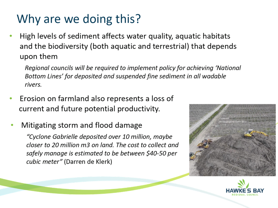
159
Dalton Street
NAPIER
|
Agenda
Item Title Page
1. Welcome/Karakia/Housekeeping/Apologies
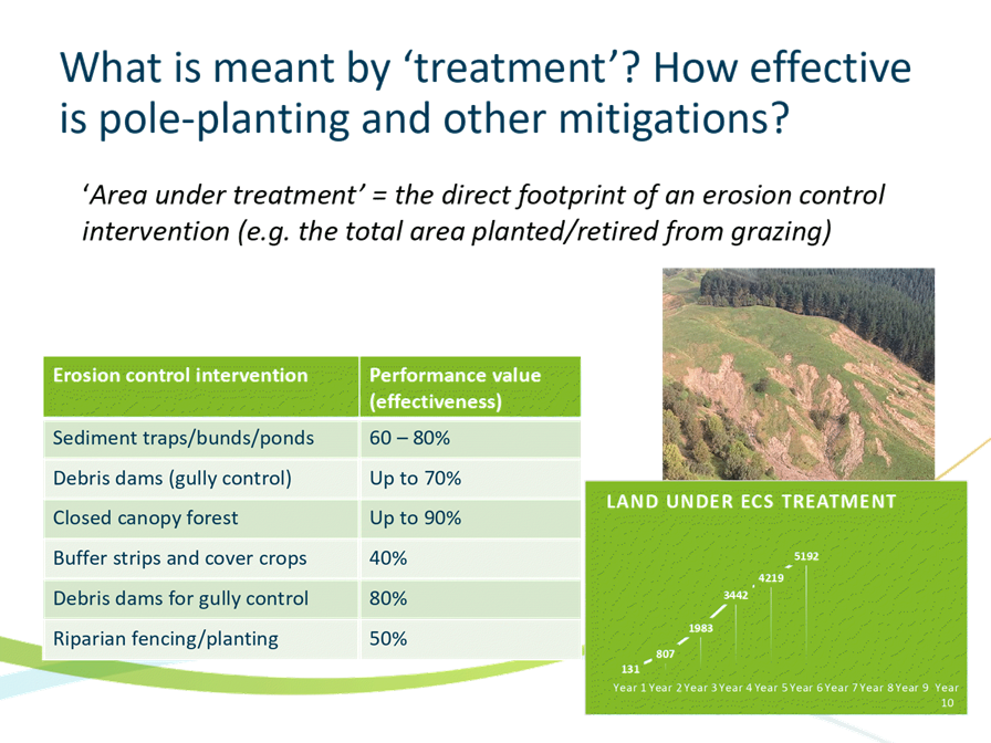
2. Conflict
of Interest Declaration
3. Confirmation of Minutes of
the Environment and Integrated Catchments Committee held on 4 December 2024
4. Public
Forum
Decision
Items
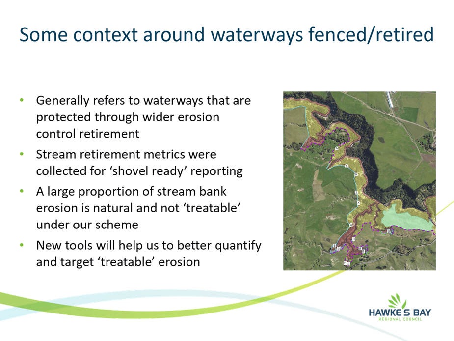
5. Te
Muriwai o te Whanga plan 5
Information
or Performance Monitoring
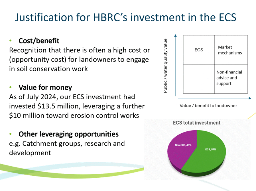
6. The
source, transport, and fate of sediment into Hawke Bay and the impact of
Cyclone Gabrielle 9
7. Effectiveness
of Trees for Landslide mitigation 13
8. Ahuriri
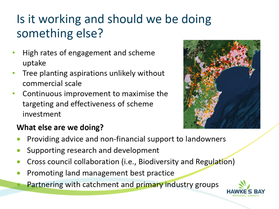
Regional Park 17
9. Erosion
Control Scheme and soil conservation in Hawke’s Bay - What's the end
game? 23
10. Connectivity
of landslides to waterways 37
11. Update
on the Kānoa-funded flood control and drainage work programme 41
12. Hawke's
Bay Future Farming Trust Annual report 49
13. Land
for Life update 55
HAWKE’S BAY REGIONAL COUNCIL
Environment
and Integrated Catchments Committee
Wednesday
09 April 2025
Subject: Public Forum
Reason for report
1. This item provides the means for the
Committee to give members of the public the opportunity to address the
Committee on matters within its terms of reference (attached).
Background
2. The Hawke’s Bay Regional
Council’s Standing Orders provide for public forums as follows:
14.
Public Forums
Public
forums are a defined period of time, usually at the start of a meeting, which,
at the discretion of a meeting, is put aside for the purpose of public input.
Public forums are designed to enable members of the public to bring matters to
the attention of the local authority.
In the case
of a committee or sub-committee, any issue, idea or matter raised in a public
forum must also fall within the terms of reference of that meeting.
Requests
must be made to the HBRC
Governance Team (06 8359200 or governanceteam@hbrc.govt.nz) at least 48 hours before the meeting; however,
this requirement may be waived by the Chairperson.
14.1 Time limits
A
period of up to 30 minutes, or such longer time as the meeting may determine,
will be available for the public forum at each scheduled Regional Council,
Corporate & Strategic Committee, Environment & Integrated Catchments
Committee and Regional Transport Committee meeting.
Speakers
can speak for up to 5 minutes. No more than two speakers can speak on
behalf of an organisation during a public forum. Where the number of speakers
presenting in the public forum exceeds 6 in total, the Chairperson has
discretion to restrict the speaking time permitted for all presenters.
14.2 Restrictions
The
Chairperson has the discretion to decline to hear a speaker or to terminate a
presentation at any time where:
·
a
speaker is repeating views presented by an earlier speaker at the same public
forum
·
the
speaker is criticising elected members and/or staff
·
the
speaker is being repetitious, disrespectful or offensive
·
the
speaker has previously spoken on the same issue
·
the
matter is subject to legal proceedings
·
the
matter is subject to a hearing, including the hearing of submissions where the
local authority or committee sits in a quasi-judicial capacity.
14.3 Questions at public forums
At
the conclusion of the presentation, with the permission of the Chairperson,
elected members may ask questions of speakers. Questions are to be confined to
obtaining information or clarification on matters raised by a speaker.
14.4 No resolutions
Following
the public forum no debate or decisions will be made at the meeting on issues
raised during the forum unless related to items already on the agenda.
Decision-making
process
3. Staff have assessed the requirements
of the Local Government Act 2002 in relation to this item and have concluded
that, as this report is for information only, the decision-making provisions do
not apply.
Recommendation
That the Environment and Integrated Catchments
Committee receives and notes the Public Forum speakers’ verbal
presentations.
Authored by:
|
Leeanne Hooper
Team Leader Governance
|
|
Approved by:
|
Desiree Cull
Strategy & Governance Manager
|
|
Attachment/s
There are no attachments for this
report.
HAWKE’S BAY REGIONAL COUNCIL
Environment
and Integrated Catchments Committee
Wednesday
09 April 2025
Subject: Te Muriwai o te Whanga plan
Reason
for Report
1. This item provides an opportunity for
the Mana Ahuriri Trust to present Te Muriwai o Te Whanga Plan and seeks
a decision to endorse the plan.
Officers’
Recommendation(s)
2. Staff recommend the endorsement of Te Muriwai o Te Whanga Plan and support for the ongoing
collaboration between Mana Ahuriri Trust and Hawke’s Bay Regional Council
to give effect to the plan and its implementation.
Background /
Discussion
3. Te Muriwai o Te Whanga Plan is a statutory planning document
developed under the Ahuriri Hapū Claims Settlement Act 2021. It sets out a
vision, values, and framework to restore and enhance the mauri of Te
Whanganui-a-Orotu (Ahuriri Estuary).
4. Te Komiti Muriwai o Te Whanga
was established under the Ahuriri Hapū Claims Settlement Act 2021 as a
permanent statutory committee. Its primary purpose is to promote the protection
and enhancement of the environmental, economic, social, spiritual, historical,
and cultural values of Te Whanganui ā Orotū. HBRC is represented on
te komiti by Chair Hinewai Ormsby.
5. On 14 February 2024 at Waiohiki marae,
te Komiti Muriwai o te Whanga formally resolved to receive the plan. Staff has
since initiated internal and partnership-focused steps to support its
implementation. HBRC staff will provide a high-level update on progress and
reaffirm the commitment to working in partnership with Mana Ahuriri Trust to
embed the plan in Council planning and operations.
6. Today’s presentation by Mana Ahuriri Trust
aims to ensure that the Committee gains a comprehensive understanding of the
plan, including the obligations and expectations of partnership between Mana
Ahuriri and the Regional Council.
7. This presentation
is an opportunity for members to engage in discussions around the
implementation of the plan and its alignment with Council’s environmental
and catchment management responsibilities.
Options
Assessment
8. Option 1 – Endorse and
support implementation of Te Muriwai o Te Whanga Plan (recommended):
·
Advantages: Aligns with Council’s
environmental and Treaty partnership responsibilities. Builds strong
relationships with Mana Ahuriri and provides a framework for collaborative
action to improve the health of Te Whanganui-a-Orotu.
·
Disadvantages: The plan includes Council’s
existing activities as well as future-focused activities. The cost and scope of
this work is currently unknown. However, Council will have the opportunity to
decide on resourcing needs in the future.
9. Option 2 – Receive Te Muriwai o Te Whanga Plan
for information only:
·
Advantages: Allows time for further scoping to be
completed.
·
Disadvantages: Inconsistent with Council’s
obligations under the Settlement Act e.g. for collaboration and support of Te
Muriwai o te Whanga. May undermine partnership and trust.
Strategic
Fit
10. This item contributes to
the Strategic Plan 2020-25 goals under the "Healthy Environment" and
"Partnerships with Tangata Whenua" visions and approaches (pg5).
11. It aligns with
Council’s obligations to give effect to Treaty settlements and supports
initiatives to protect and enhance the ecological and cultural values of
significant natural areas.
Significance
and Engagement Policy Assessment
12. This matter has moderate
significance under the Council’s Significance and Engagement Policy
because:
12.1. High tangata whenua interest
12.2. High council strategic alignment
12.3. Has public interest
12.4. No immediate large financial commitments
12.5. No change to council’s strategic assets or core
services
13. While it does not represent a
significant change to service provision, it relates to the implementation of a
statutory document and involves tangata whenua as Treaty partners. Ongoing
engagement will occur through partnership mechanisms.
Financial
and Resource Implications
14. Implementation of Te Muriwai o Te Whanga Plan will require both staff time and
dedicated resourcing over time.
15. While no immediate budget increase is
required, further scoping is underway to identify areas where funding may be
needed for joint projects, monitoring, or restoration initiatives. Future
funding may be sought through Long Term Plan processes or external sources.
Decision
Making Process
16. Council and its committees
are required to make every decision in accordance with the requirements of the
Local Government Act 2002 (the Act). Staff have assessed the requirements in
relation to this item and have concluded:
16.1. The decision does not significantly
alter service provision or affect a strategic asset, nor is it inconsistent
with an existing policy or plan.
16.2. The use of the special consultative
procedure is not prescribed by legislation.
16.3. The decision has moderate significance
under the criteria contained in Council’s adopted Significance and
Engagement Policy.
16.4. The persons affected by this decision
are tangata whenua, particularly Mana Ahuriri, and all persons with an
interest in the management of Te Whanganui-a-Orotu.
16.5. Given the nature and significance of
the issue to be considered and decided, and also the persons likely to be
affected by, or have an interest in the decisions made, Council can exercise
its discretion and make a decision without consulting directly with the wider
community.
Recommendations
1. That Environment and Integrated
Catchments Committee receives and considers Te Muriwai o Te Whanga Plan staff report.
2. The Environment and Integrated Catchments Committee
recommends that Hawke’s Bay Regional Council:
2.1 Agrees that the
decisions to be made are of moderate significance under the criteria contained
in Council’s adopted Significance and Engagement Policy on the basis that
the work and the relationship involved are important however no decision for resourcing
is required and Council can exercise its discretion and make decisions on this
issue without conferring directly with the community or persons likely to have
an interest in the decision.
2.2 Endorse and
support implementation of Te Muriwai o Te Whanga Plan.
Authored by:
|
Jack Smith-Ballingall
Māori Partnerships Manager -
Central & Internal Relationships
|
|
Approved by:
|
Te Wairama Munro
Te Pou Whakarae
|
|
Attachment/s
|
1⇨
|
Te muriwai o te whanga plan
|
|
Under Separate Cover
Online only
|
|
2⇨
|
HBRC's Te muriwai o te whanga action
plan
|
|
Under Separate Cover
Online only
|
HAWKE’S BAY REGIONAL COUNCIL
Environment
and Integrated Catchments Committee
Wednesday
09 April 2025
Subject: The source, transport, and
fate of sediment into Hawke Bay and the impact of Cyclone Gabrielle
Reason for report
1. This report is a summary of the
results from the hydrodynamic model developed by an HBRC funded PhD student,
Ted Conroy, from the University of Waikato.
2. The hydrodynamic model was created to
improve the understanding on the origin, transport, and fate of fine sediments
in Hawke Bay.
3. The model will also improve our
understanding of wind waves, as well as oceanic currents induced by tide and
wind, as this data was not available for Hawke’s Bay in useful spatial
and temporal scales.
4. The ocean model that was developed
from the PhD project simulated the period during and after Cyclone Gabrielle.
The model was used to investigate the sediment transport into the ocean and the
fate of sediments after the cyclone.
Executive
summary
5. As a part of the PhD project, multiple
methodologies identified the ocean circulation and sediment transport patterns
in Hawke Bay. These methods included the use of satellite remote sensing, the
collection of oceanographic data, and the creation of an ocean model for the
Hawke’s Bay region.
6. An ocean model was developed for the
Hawke Bay and surrounding coastal ocean. The model was calibrated and validated
against a wide range of collected data, including from HBRC’s coastal
water quality monitoring buoy (HAWQi). Model outputs emphasized that riverine inputs of freshwater to
Hawke Bay are a substantial feature of the general circulation of Hawke Bay.
7. An oceanographic dataset collected
offshore of the Tukituki River highlighted the importance of wind on how water
from rivers is transported in the coastal ocean in high detail.
8. Satellite remote sensing was used to
develop a twenty-year catalog of the ocean surface suspended sediment
concentration in Hawke Bay. This dataset revealed that suspended sediment from
river plumes can extend up to 6 km from river mouths.
9. The amount of sediment that entered
the ocean from Cyclone Gabrielle was modelled to be 20.12 million tons. The distribution and fate of sediment
from the Cyclone was shown for periods directly after the cyclone and in the
following two months.
Strategic
fit
10. This report contributes to our
strategic goal of having community-agreed water quality limits by informing the
sediment load in the waterways and delivered to the coast.
11. This work will contribute
to the next State of the Environment report, including post cyclone impacts on
the coastal marine area.
12. This work will contribute
to the development of the Regional Policy Statement and management of the
coastal marine area.
13. This work contributes to
our understanding of present and future coastal flood and erosion drivers.
14. This work will contribute
to our strategic goal of sustainable and climate-resilient services and
infrastructure.
15. Coastguard Hawke’s Bay will use this
work for offshore rescue operations.
Background
16. One of the largest threats to coastal
marine area is sediment from land both suspended in the water and deposited on
the seabed.
17. There is a lack of current information
regarding the transport and fate of sediment to the Hawke’s Bay Coastal
Marine Area. Research into the sediments of Hawke’s Bay has been
piecemeal and often spatially limited.
18. A limited number of oceanographic
studies have been done in Hawke Bay, and the water circulation is poorly
documented.
19. The present model can help us
understand the amount and dynamics of river sediment deposits along Hawke
Bay’s coast, and their role in supplying our beaches. The insights on
sediment supply and drift that this data provides can be significantly helpful
for our coastal erosion and management strategies.
20. The purpose-built hydrodynamic model
that has been developed for Hawke Bay allowed us to apply the model to the
period of Cyclone Gabrielle.
Discussion
21. Satellite remote sensing data showed typical
patterns of turbid river plumes and the relationship between suspended sediment
concentrations and environmental conditions. Elevated concentrations of suspended sediment in river
plumes ranged from 2 to 6 km from the river mouths.
21.1. It was also observed that wave and
wind events remobilize sediment from the seabed to the surface ocean.
22. From oceanographic data collected
offshore of the Tukituki River, the response of a river plume to environmental
conditions was observed in high detail. It was found that the river plumes
responded strongly to wind variability, displaying distinct patterns in
acceleration, stratification, and mixing with varying wind orientations. These
results detail the oceanographic processes in Hawke Bay that are important for
the initial transport of terrestrial substances that enter the coastal ocean.
22.1. It was found that the relationship between various wind
directions and oceanographic conditions in the river plumes differed from
larger river systems, which have been more commonly studied, than the rivers
found in Hawke’s Bay. Large rivers are more affected by the Coriolis
force, Earths rotational influence on moving objects. For the size of rivers
found in Hawke Bay, the offshore wind is the most significant mechanism for
transporting terrestrial material further from the river mouths.
23. The use of an ocean model for Hawke
Bay enabled a detailed description of current patterns to be established. These
patterns were described for annual, seasonal, and event-based timescales. The model also provided estimations of
short-term and long-term sediment deposition in the coastal marine area.
23.1. The typical circulation pattern in Hawke Bay at the
surface was found to show outflow from each headland of the bay and inflow into
the middle of the bay. This pattern is most impacted by varying wind and river
plume features.
23.2. From the model,
sediment accumulation in Hawke Bay mostly occurred in depths between 20 and 60
m. Near seabed currents from waves acted to resuspend sediment in shallower
regions less than 5 m deep.
24. The high-intensity winds and waves
during Cyclone Gabrielle drove a strong ocean circulation in Hawke Bay. The
peak in river discharge occurred after the peak winds, when the wind speed had
lessened and changed directions. The directionality of the river plumes, and
the initial sediment deposition to the seabed, was influenced by the wind
direction following the cyclone.
24.1. Following the cyclone, the mass of
sediment transported into Hawke Bay deposited in varying depth ranges
throughout Hawke Bay was quantified.
24.2. By the end of April
2023, the mass of sediment from the Cyclone was mostly found in waters
shallower than 20 m depth (~60%) but was also distributed throughout deeper
waters (~20%) as well as transported outside of Hawke Bay (~20%).
24.3. The model showed that the suspended
sediment concentration at the ocean surface returned to pre-cyclone levels
within one week, while the concentrations near the seabed returned to
pre-cyclone levels within five weeks.
24.4. The sediment deposition from the cyclone in the model
showed deposits in the range of 125 mm directly offshore of river mouths to a
few mm further offshore in depths greater than 40 m deep. These results broadly
agree with the deposit thicknesses that were measured from NIWA’s post
cyclone sediment cores.
24.5. The modelled deposits from the cyclone are concentrated
within the vicinity of each river mouth, and no singular river’s deposit
footprint encompasses a majority of the seabed within Hawke Bay.
Next
steps
25. The work presented today, along with
all post cyclone monitoring in the coastal marine environment, will feed into
the upcoming State of the Environment report and Regional Policy Statement.
26. The model data will
be used for Coastal Management including the Westshore Renourishment Programme
Review, and potentially for the next steps of the Clifton to Tangoio Coastal
Hazards Strategy
Decision-making
considerations
27. Staff have assessed the requirements
of the Local Government Act 2002 in relation to this item and have concluded
that, as this report is for information only, the decision-making provisions do
not apply.
Recommendation
That the Environment and Integrated Catchments
Committee receives and notes The source, transport, and fate of sediment
into Hawke Bay and the impact of Cyclone Gabrielle staff report.
Authored by:
|
Ted Conroy
Coastal Oceanographer, ECoast
|
Joao Albuquerque
Coastal Specialist
|
|
Becky Shanahan
Senior Scientist Marine & Coasts
|
|
Approved by:
|
Richard Wakelin
Acting Group Manager Integrated
Catchment Management
|
|
Attachment/s
|
1⇨
|
Conroy Ted Thesis - The Sediment,
River Plume, and Inner Shelf Variability in a Bay with Multiple Fluvial
Inputs
|
|
Under Separate Cover
Online only
|
HAWKE’S
BAY REGIONAL COUNCIL
Environment
and Integrated Catchments Committee
Wednesday
09 April 2025
Subject: Effectiveness of Trees for Landslide
mitigation
Reason for Report
1. HBRC contracted Manaaki
Whenua – Landcare Research (MWLR) to assess the effectiveness of
individual trees in reducing the occurrence of rainfall-induced shallow
landslides on farms in the region following the impacts of Cyclone Gabrielle.
2. This information will help HBRC
communicate to stakeholders how existing trees in pastoral areas affected the
number of landslides triggered by the cyclone. It will also assist with
targeting future tree planting to those areas on a farm that are most susceptible
to landslides and where landslides are most likely to deliver sediment to
streams.
3. The research assesses the
effectiveness of trees on 50 selected farms in the region for shallow landslide
mitigation with the delivery of spatial layers
alongside a report. It was completed under the Extreme Weather Recovery
Advice Fund for $80,000.
Executive
Summary
4. This research estimates the magnitude
of reductions in the number of shallow landslides and the amount of landslide
sediment delivered to streams that might have been achieved by the presence of
individual trees of any description in pastoral areas during Cyclone Gabrielle.
5. The presence of trees in pastoral
areas achieved an estimated median 7% (or 1,865 additional landslides)
reduction in landslide numbers across the 50 farms analysed. When expressed as
sediment yield, this equated to a median 10% decrease in landslide erosion.
6. The existing tree cover on pastoral
land led to an estimated 9% reduction in landslide sediment delivery to streams
when summed across all farms. This proportional reduction equates to
approximately 16,150 t of sediment.
7. The main driver of the
reductions in sediment delivery was tree density in pastoral areas highly
susceptible to landslides, where landslide runout was likely to connect with
the stream network. Modelling under the treeless baseline scenario showed only
5.7% (9.6 km²) of the total pastoral area on the farms is both highly
susceptible to shallow landsliding and has high potential for sediment delivery
to the stream network. However, due to the actual tree cover (real scenario),
this class is reduced to 4.7% of the total area. The class reduction resulted
in the prevention of an additional 1,865 landslides occurring (8.4%), or, when
expressed as gross landslide erosion, 0.23 × 10⁶ t of eroded
material.
Strategic
Fit
8. This research links through to the
Strategic Plan goals:
8.1. By 2050, all highly erodible land is
under tree cover;
8.2. By 2050, there will be 50% fewer
contaminants from urban and rural environments in receiving waterbodies.
9. It illustrates the success of some
mature farm plantings to date.
10. The research links to the report by
MWLR on ‘Regional Shallow Landslide Connectivity Modelling.
Background
11. Cyclone Gabrielle triggered large
numbers of shallow landslides that caused widespread damage to land across
Hawke’s Bay and delivered significant amounts of sediment to downstream
receiving environments. HBRC wants to better understand the effectiveness of
individual trees in pastoral areas for reducing landslide erosion on farms in
the region.
12. The influence of individual trees on
farm-scale landslide erosion and sediment loads was modelled for (a) the
baseline scenario, whereby existing trees in pastoral areas were removed; and
(b) the contemporary tree cover scenario. The analysis used a tree map produced
for HBRC by MWLR as part of the HBRC–MWLR LiDAR partnership project
(2022–2024) and a landslide inventory for Cyclone Gabrielle from the
GNS-led mapping project.
13. The selection of farms for analysis
focused on pastoral areas on farms that experienced high rainfall during
Cyclone Gabrielle but varied levels of landsliding. The AgriBase data set was
used to identify farm boundaries, and the New Zealand Land Cover Database (LCDB
v5.0, 2018) was used to retrieve the farm-pasture polygons.
14. An existing statistical model,
representing the influence of individual trees on landslide susceptibility, was
updated using available data on individual trees and a 2020 LiDAR-derived
digital elevation model (DEM) for pastoral areas with landslide scar area
data. The landslide area data included scar-mapping data from the March
2022 storm events in northern Hawke’s Bay.
15. -MWLR estimated sediment delivery to
streams by shallow landslides for the two scenarios. The difference in
landslide occurrence between the two scenarios was used to estimate the
reduction in landslide erosion and sediment delivery to streams associated with
the presence of individual trees on pastoral land.
Effectiveness
of trees on farms
16. MWLR estimated 20,392 shallow
landslides were triggered by Cyclone Gabrielle across the selected farms.
The associated erosion was an estimated 2.54x10⁶ tonnes, 7.5% of
which reached the stream network. This equates to a median sediment yield of
723 t/km2 on the farms being delivered to streams.
17. Under the scenario of all trees being
removed from the pastoral areas, MWLR estimated 22,257 landslides would have
been triggered, yielding 2.77x10⁶ tonnes of sediment. Delivery
to streams rises to a median 813 t/km2.
18. Across the 50 farms and under the
treeless scenario, MWLR found 5.7% of the total pastoral areas is both highly
susceptible to shallow landsliding and has high potential for sediment to enter
streams. The presence of trees reduces this area to 4.7%.
19. Overall, an estimated 1,865 landslides
were prevented by the presence of trees, with a median farm-scale reduction in
landslide count of 7%. An estimated 16,150 tonnes of sediment was prevented
from reaching the stream network. It leads to a median 10% farm-scale decrease
in sediment yield to streams. The latter rises to a 24% decrease in
places where the trees are in close proximity to streams and on susceptible
slopes.
20. The density of trees influences the
reduction in shallow landsliding. On farms that achieved a
reduction in sediment yield greater than or equal to 15%, the density ranged
from 145-241 trees/km2, with an average of 193 trees/km2.
Farms achieving less than 5%, had an average of 85 trees/km2 (32-160
trees/km2).
Discussion
21. The work by MWLR shows that planting
trees, with reasonable density, can reduce the number of shallow landslides and
the sediment yield to streams. The density appears key to improving
success and planting vulnerable slopes close to streams is particularly
beneficial.
22. A limitation of the work is that only
50 farms in the region were assessed and therefore not all vulnerable
properties were mapped. It is possible to scale up tree effectiveness mapping
if there is demand for that work.
Next
Steps
23. Further reductions in
future landslide sediment delivery to streams could be achieved through
additional tree planting targeting pasture areas that are highly susceptible
and highly likely to produce landslides that connect to streams. These areas
have been identified in the farm-scale landslide susceptibility and
connectivity maps accompanying the published report.
24. Share information with Catchment
Management and catchment groups to illustrate the reductions in sediment loss
and delivery to streams of planting trees on erosion-prone areas of farms.
Similarly, inform the Land For Life Programme of these learnings to aid in
their future planning and modelling.
Decision
Making Process
25. Staff have assessed the requirements
of the Local Government Act 2002 in relation to this item and have concluded
that, as this report is for information only, the decision-making provisions do
not apply.
Recommendation
The Environment and Integrated Catchments
Committee receives and notes the Effectiveness of trees for landslide
mitigation staff report.
Authored by:
|
Dr Ashton Eaves
Senior Scientist - Land
|
|
Approved by:
|
Richard Wakelin
Acting Group Manager Integrated
Catchment Management
|
|
Attachment/s
|
1⇨
|
Report of findings - Assessing the
effectiveness of trees for landslide mitigation in Hawke's Bay 2024
|
|
Under Separate Cover
Online only
|
HAWKE’S
BAY REGIONAL COUNCIL
Environment
and Integrated Catchments Committee
Wednesday
09 April 2025
Subject: Ahuriri Regional Park
Reason for Report
1. This item is to introduce the Ahuriri
Regional Park Joint Committee Chair, Deputy Mayor (Napier City Council) Annette
Brosnan and accompanied by members of the Joint Committee who will be attending
in person to present on the progress of the Ahuriri Regional Park Joint
Committee.
2. Attached to this cover report is a
Napier City Council report.
Decision
Making Process
3. Staff have assessed the requirements
of the Local Government Act 2002 in relation to this item and have concluded
that, as this report is for information only, the decision-making provisions do
not apply.
Recommendation
That the Environment and Integrated Catchments Committee receives
and notes the Ahuriri Regional Park staff report.
Authored and approved by:
|
Chris Dolley
Group Manager Asset Management
|
|
Attachment/s
|
1⇩
|
ARP NCC Paper
|
|
|
|
2⇩
|
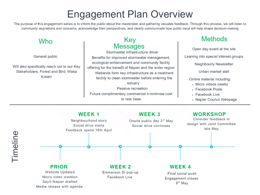
Appendix 1 ARP - Engagement Overview
|
|
|
|
3⇨
|
Appendix 2 ARP - Draft Masterplan -
March 2025
|
|
Under Separate Cover
Online only
|
|
ARP NCC Paper
|
Attachment
1
|
|
Appendix 1 ARP - Engagement Overview
|
Attachment
2
|
HAWKE’S
BAY REGIONAL COUNCIL
Environment
and Integrated Catchments Committee
Wednesday
09 April 2025
Subject: Erosion Control Scheme and
soil conservation in Hawke’s Bay - What's the end game?
Reason for report
1. This
paper addresses questions raised following an Erosion Control Scheme (ECS)
update to the EICC in December 2024. These were in relation to the goals,
methods, effectiveness and value proposition of the ECS, specifically:
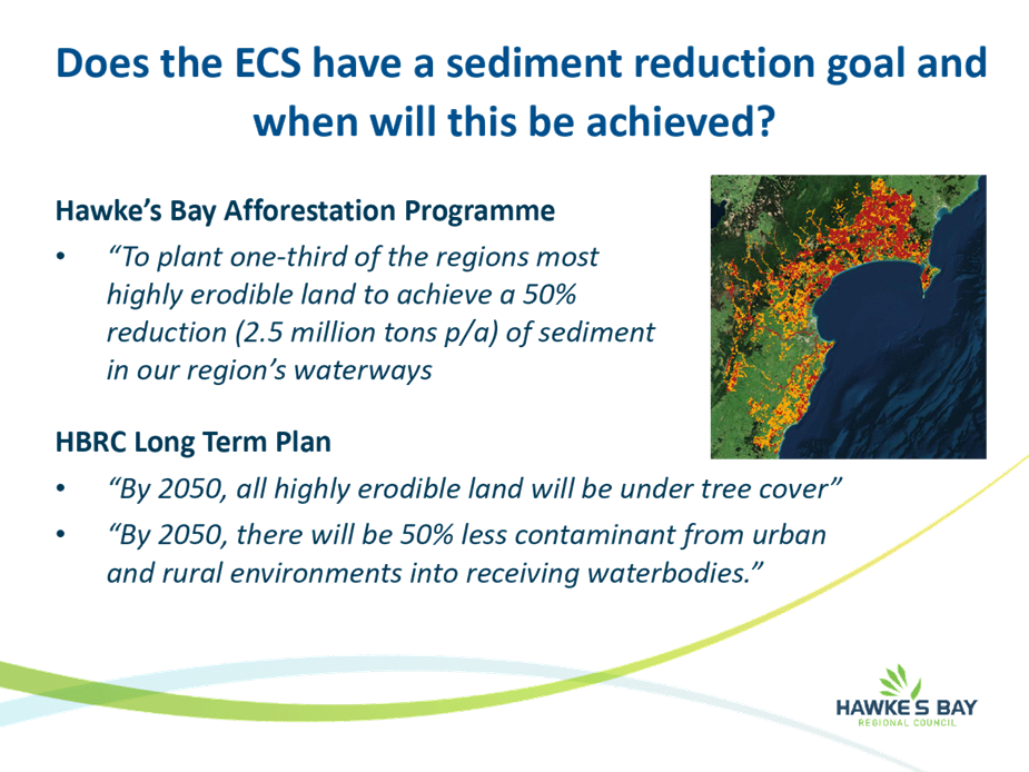
1.1. Does the ECS have a sediment reduction
goal and when will this be achieved?
1.2. What is meant by
‘treatment’?
1.3. How effective is pole planting and
other mitigation?
1.4. What is the context around waterways
protected?
1.5. What is HBRC’s justification for
a 30-million-dollar investment in the ECS over ten years?
1.6. Why are we doing this? Is the
programme working, and should we do something else?
Executive
summary
2. The ECS was first implemented in 2018
as part of the Hawke’s Bay Afforestation Programme (HBAP). The HBAP has a
goal to reduce sediment loss to our region’s waterways by 50% through
planting one third of the region’s most highly eroding land. The current
Long-Term-Plan has a more ambitious goal to have all the region’s highly
erodible land under tree cover by 2050.
3. The Catchment Management team collects
data on ‘area of land treated’ for reporting purposes, with the
understanding that measurable water quality outcomes will be realised over a
longer timeframe.
4. Soil conservation planting and other
interventions are based on well-established research.
5. A $30 million investment in the ECS
over ten years recognises that the public/environmental good of soil
conservation work is often at a disproportionate cost to landowners. The
programme is achieving good uptake, however there is a need for a commercial instrument
to enable the level of tree planting advocated for.
6. The ECS is a tool that the HBRC uses
to manage erosion and sediment loss alongside other regulatory and
non-regulatory methods.
7. Councils land and freshwater science programmes are
essential for:
7.1. Targeting areas for the most effective
investment in erosion control
7.2. Benchmarking and providing context for
output-based reporting
7.3. Monitoring long-term erosion control
outcomes
Strategic
fit
8. The ECS and its supporting programmes
align with the following HBRC Strategic Plan outcome:
“Hawke’s
Bay farmers and growers are thriving and maximising returns from resilient
farming systems through smart, sustainable land use.”
9. It directly supports the strategic
goals listed below:
9.1. “By 2050, all highly erodible
land is under tree cover.”
9.2. “By 2030, flood risk is being
managed to adapt to foreseeable climate change risks out to 2100.”
Background
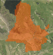
10. Approximately 252,000 hectares of Hawke’s
Bay hill country has been identified as being at high risk of erosion. It is
estimated that anthropogenic erosion contributes, on average, 3.27 million
tonnes of sediment into the region’s waterways yearly. That’s
an average of 136,000 truck and trailer loads of sediment per year.
11. High levels of sediment affects the
region’s water quality and aquatic habitats, as well as the biodiversity
that depends upon them. Erosion on farmland also represents a loss of current
and future productivity.
12. The ECS is a loan-funded grant scheme
that enables non-commercial tree planting and other erosion control works on
highly erodible land in Hawke’s Bay. It has an operational budget of $30
million over ten years. This budget primarily funds on-ground erosion control
works and leverages co-funding from landowners and other funding partners.
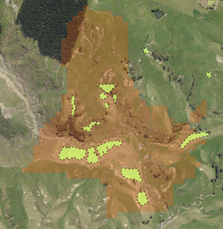
13. As of July 2024, the ECS had engaged
with over 500 properties resulting in the direct treatment of 5,075ha of highly
erodible land.
Discussion
Does the ECS have a sediment reduction goal and when will
this be achieved?
14. The Hawke’s Bay Afforestation
Programme (HBAP), which included the ECS and a conceptual ‘Right Tree
Right Place’ programme’ was conceived under the Kahuta Accord in
2017.
15. The HBAP had a goal to plant one third
of the region’s most highly erodible land. This would achieve a 50%
reduction in annual average sediment loss to waterways based on SedNet
modelling at the time (i.e. a reduction of 25 million tonnes through the
planting of 83,000ha). It was envisaged that the two schemes would plant an
average of 2000ha per year.
16. The HBRC Long Term Plan 2021 –
2031 goes a step further, stating that “by 2050 all highly erodible
land will be under tree cover”. A high-level aspirational statement
that somewhat over-simplifies the issue and solution. However, the intended
sediment reduction outcomes would still be achievable through the ‘widescale
adoption of soil conservation best practice’ on highly erodible land.
This will require further targeted effort and investment, informed by robust
land and freshwater science programmes.
17. Other factors that will influence
erosion control (and sediment reduction) effort:
17.1. The uptake of land and soil management practices that do
not necessarily include planting.
17.2. Commercially driven land use change (e.g. The Emissions
Trading Scheme (ETS), production forestry conversion, market accreditation
programmes)
17.3. The voluntary protection and restoration of land for
biodiversity (e.g. partnerships with the QEII Trust)
17.4. Regulatory drivers (e.g. direct controls on land use,
requirements to offset emissions/ leaching).
What
is meant by ‘under treatment’?
18. Area ‘under treatment’
refers to the direct footprint of an erosion control project (e.g. the total
area planted/retired from grazing). For reporting purposes, an area is
considered ‘under treatment’ when a project has been completed to
an acceptable standard for grant payment to be released.
19. HBRC and other scheme sponsors (i.e.
the Hill Country Erosion Fund) require annual ‘output-based’
reporting, accepting that water quality outcomes will be measured over a much
longer timeframe.
20. Area under treatment does not include
land treated prior to, or independent of the ECS. Output reporting does not
capture social and behavioral changes that result in more sustainable land and
soil management.
21. There is limited geo-spatial recording
of land treated prior to, or independent of the ECS. We rely on our land
science programmes to capture land use/cover changes over time through remote
sensing and aerial imagery (i.e. for benchmarking and targeting works).
How effective is pole planting and other mitigation?
22. Research shows that effective erosion
control planting can reduce erosion by up to 70% for space planted
poplar/willow, and up to 90% for closed canopy forest (Basher, L. 2016).
23. For much of our highly erodible land
(i.e. land losing more than 1,000kg of sediment per hectare per year), sediment
loss could be reduced by between 700 – 900kg per ha /yr.
24. Commonly
used performance values for other soil conservation interventions include
(Phillips C, Basher L, Spiekermann R, 2020):
24.1. Sediment retention ponds, traps and
bunds to manage surface erosion (60 – 80%)
24.2. Buffer strips and cover crops to
manage surface erosion (40%)
24.3. Debris dams used to manage gully
erosion (80%)
24.4. Riparian fencing and/or planting to manage streambank erosion (50%)
25. Erosion control interventions that are
known to be effective but difficult to quantify in terms of sediment loss,
include de-watering/spring tapping and behavioral changes that lead to improved
cultivation and grazing management.
What is the context around waterways treated?
26. Metrics for waterways fenced and
protected were recorded to satisfy the reporting requirements of the Hapara
Takatu (shovel ready) programme, where the ECS leveraged close to $2 million of
MfE funding toward riparian fencing between 2019 and 2023.
27. There is value in continuing to report
length of waterway protected as it represents a level of protection over and
above any regulatory requirements. However, we acknowledge that more work is
required to provide meaningful context.
28. Streambank erosion in higher order
streams is often innate and dynamic and therefore difficult to address through
traditional riparian management and bio-engineering methods.
29. There is a need to benchmark and
target waterways where riparian management interventions for stream bank
erosion will be most effective.
What is the justification for a 30-million-dollar
investment in the ECS?
30. The ECS represents a partnership
between HBRC and landowners to achieve water quality outcomes. Landowners have
a responsibility to be good land stewards, however there is often a
disproportionate cost (and/or opportunity cost) for landowners to undertake
works that have a public good. The ECS co-funds erosion control where the cost
of implementation outweighs the private benefit received by the landowner.


31. Prior to the ECS, HBRC’s Land Management team operated
the Regional Landcare Scheme (RLS), The RLS had an annual budget of ~$800k
mostly to support soil conservation, but also included projects with a
biodiversity focus. The HBAP was formed with the intention of accelerating
water quality outcomes in line with local and national expectations.
32. Return on investment. To date HBRC has
invested
around $13.5 million toward the ECS. This has leveraged a further $10 million
at least, toward planting and other related activities. In 2008, hill country erosion was estimated
to be costing New Zealand between $100 and $150 million per year
annually (Jones et al., 2008).
Why are we doing this?
33. HBRC
uses a combination of regulatory and non-regulatory mechanisms for meeting
national and local water quality
standards. Sediment is our regions foremost water quality stressor. As a
non-point source contaminant, regulatory policy options for managing
erosion-derived sediment are constrained and difficult to apply.
34. While the focus of the ECS has been on
water quality, we know that during extreme weather events, huge quantities of
erosion generated sediment is also deposited on land. The most significant and
costly impacts of erosion are experienced not on hill country but on low-laying
flat country.
34.1. Damage to public and private
infrastructure
34.2. Damage to producing land and crops
34.3. Reduced capacity of waterways / flood
channels
35. Cyclone Gabrielle deposited over 10
million, maybe closer to 20 million m3 on land. The cost to collect and safely
manage is estimated to be between $40-50 per cubic meter” (Darren de Klerk, 2024)
Is it working and should we do something else?
36. While the scheme is a long way off
achieving the scale of planting proposed through the HBAP, this has been
achieved without any commercial scale planting proposed through Right Tree
Right Place.
37. We do sell ourselves short when we
compare ‘treated area’ metrics with erosion modelling used to
benchmark the scale of our erosion issue. Output based reporting will not
necessarily align with, or capture, the total area that receives benefit from
erosion control works.

38. Since the ECS was established in 2018,
Catchment Advisors have engaged with no less than 503 individual properties,
covering roughly two thirds of the region’s farmland identified as highly
erodible.
39. The Catchments Team has begun a
programme to review the effectiveness of planting and other works since the
inception of the ECS. However, we are reliant on land and freshwater science
programmes to monitor the long-term effectiveness of these works.
Land for life
40. We are beginning the process of
recruiting 80 properties with highly erodible land for the next phase of the
Land for Life project. This will extend to 300 in the coming years towards a
ten-year goal of 600 farms.
Should we be doing something else?
41. While the ECS is our primary tool for
facilitating erosion control work on private land, our catchment team are
engaged in a range of activities for achieving behavioral change concerning
erosion derived sediment.
41.1. Providing advice and non-financial
support to landowners outside of the ECS
41.2. Supporting research and development
(Crown Research Institutes and ‘on farm’ research programmes)
41.3. Cross council collaboration (e.g.
supporting our biodiversity and regulation teams)
41.4. Promoting land management best
practice through workshops and extension programmes
41.5. Partnering with catchment and primary
industry groups
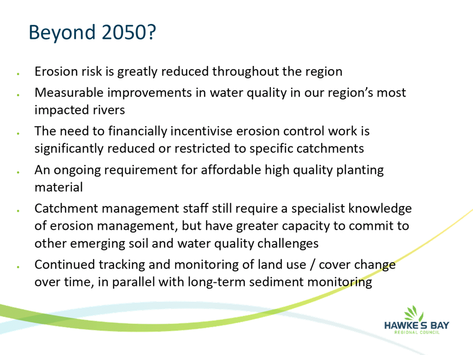
42. Beyond 2050…?
42.1. Erosion risk will be greatly reduced
throughout the region
42.2. Measurable improvements in water
quality in our region’s most sediment impacted rivers
42.3. The need to financially incentivise
erosion control work would be greatly reduced or restricted to case by case
situations
42.4. There will be an ongoing requirement
for affordable high quality planting material
42.5. Catchment management staff would still
require a specialist knowledge of erosion management, but will have greater
capacity to commit to other emerging soil and water quality challenges
42.6. Continued tracking and monitoring of
land use / cover change over time, in parallel with long-term water quality and
sediment monitoring
Decision-making
considerations
43. Staff have assessed the requirements
of the Local Government Act 2002 in relation to this item and have concluded
that, as this report is for information only, the decision-making provisions do
not apply.
Recommendation
That
the Environment and
Integrated Catchments Committee receives and notes the Erosion Control Scheme and soil conservation
in Hawke’s Bay - What's the end game? staff
report.
Authored by:
|
Warwick Hesketh
Principal Advisor Catchment
Management
|
Jolene Townshend
Manager Catchment Operations
|
Approved by:
|
Richard Wakelin
Acting Group Manager Integrated Catchment
Management
|
|
Attachment/s
|
1⇩
|
The Erosion Control Scheme and soil
conservation in Hawke's Bay - what is the end game?
|
|
|
|
The Erosion Control Scheme and soil
conservation in Hawke's Bay - what is the end game?
|
Attachment
1
|
HAWKE’S BAY REGIONAL COUNCIL
Environment
and Integrated Catchments Committee
Wednesday
09 April 2025
Subject: Connectivity of landslides to
waterways
Reason for report
1. To get a better understanding of the
possibility of sediment delivery from shallow landslides to waterways at a
regional scale. This can inform landowners of their susceptibility to slips and
land use suitability.
2. Hawke’s Bay Regional Council
(HBRC) contracted Manaaki Whenua – Landcare Research (MWLR) to produce
information on how the spatial likelihood of landslides connecting with the
stream network varies across the region. This information, when combined with
the regional landslide susceptibility layer, identifies at high resolution (5
m) those areas that are both highly susceptible to landslides and highly likely
to deliver sediment to streams in the future. This combination provides the
best available information at a regional scale for targeting erosion control to
reduce both onsite soil damage or loss as well as downstream sedimentation and
water quality impacts.
3. As part of this project, HBRC asked
MWLR to estimate the topographic wetness index (TWI) to support land use
planning.
Executive
summary
3. The combined regional rainfall-induced shallow landslide
susceptibility and connectivity layer provide the council and the public with
high-resolution spatial information. Its uses include land use suitability
planning and erosion control activities, such as better targeting of tree
planting on areas of pastoral land most susceptible to instability and likely
to deliver sediment to streams.
4. Using the landslide morphometric
connectivity model framework, MWLR estimated shallow landslide-to-stream
connectivity for the Hawke’s Bay region.
5. The high-resolution TWI
estimates are based on the 2020 LiDAR-derived DEM to identify critical source
areas to support land and water planning in the region.
Strategic
fit
This research
links through to the Strategic Plan goals:
5.1. By 2050, all highly erodible land is
under tree cover;
5.2. By 2050, there will be 50% fewer
contaminants from urban and rural environments in receiving waterbodies.
5.3. By 2030 there is an increasing trend
in the life-supporting capacity of all of the region’s degraded rivers
and major streams.
6. Contributes to healthy, functioning
and climate-resilient biodiversity.
7. The modelling gives vastly improved
detail to the Erosion Control Scheme on target areas than the Erosion
Susceptibility Classification.
8. The research links to the report by
MWLR on the ‘Effectiveness of Trees for Landslide Mitigation’.
Background
9. Region-wide predictions of
shallow landslide-to-stream connectivity were produced with probability- and
class-based scales, while the TWI was estimated across the region and supplied
as geospatial layers.
10. The probability and
class-based scales describe the susceptibility to both landsliding and the
landslide to stream connectivity. The seven classes range from “Low
Landslide Susceptibility (Low LS)”, which encompasses all levels of connectivity,
to “High Landslide Susceptibility/High Connectivity (High LS/High
Con)”.
11. The Cyclone Gabrielle landslide data
provided an independent validation of the mapped connectivity classes. MWLR
found that 62% of all Gabrielle-related landslides that connected to streams
had source areas located within the ‘High’ connectivity class area,
while 21% occurred in the ‘Moderate’ class and 17% in the
‘Low’ class.
12. The TWI identifies areas
that are prone to saturation and the generation of surface runoff. Following (2023) Ministry for the
Environment guidance for critical source areas, MWLR estimated the TWI based on
the LiDAR-derived DEM at 5 m horizontal resolution.
Landslide-to-stream connectivity
13. The class-based
landslide-to-stream connectivity geospatial layer was combined with the
previously supplied class-based shallow landslide susceptibility layer (HBRC
– MWLR LiDAR Project) attachment 1 (under separate cover).
14. To be landcover agnostic,
all forestry land mapped in the New Zealand Land Cover Database (LCDB v5.0) was
converted to grass cover for analysis to illustrate the possible susceptibility
across the whole productive landscape. We modelled all forestry areas with
grass cover (to recognise the post-harvest period of elevated landslide
susceptibility) to allow comparison with pastoral land, but other areas (mostly
those with permanent native woody cover) were modelled with their land covers
as mapped in LCDBv5 (2018).
15. The resulting combined
class-based layer may be used to identify areas that are both highly
susceptible to landsliding and likely to generate runout that reaches the
stream network.
16. Most of the land in
Hawke’s Bay lies in the Low Landslide Susceptibility (LS) class.
Approximately 3.42% (539 km2) of the region is within the High
LS/High Con class.
Discussion
17. The work assists the Council with the
assessment of forestry harvesting consents as it provides higher resolution
vulnerability mapping than the Erosion Susceptibility Classification.
18. The work also assists Catchment
Advisors and pastoral farmers in identifying where land treatments for erosion
mitigation are required and would make the most impact on soil conservation and
water quality. Treatments, such as space-plantings or native reversion, not
only include the steep faces at the tops of hills but also where streambank and
gully erosion are prevalent where riparian buffers may be more applicable.
19. These maps will be useful for farm
planning and the production of farm plans to manage natural hazards.
20. These layers are already in use by the
consent and compliance teams to identify hotspots for susceptibility and
connectivity on forestry blocks requiring resource consent to harvest. Forestry
companies are also using it for the same reasons.
21. Gisborne recruited MWLR for a similar
assessment to develop their ‘Overlay 3B’ layer for returning land
to permanent forest, attachment 2 (under separate cover) - Uawa
Catchment Working Group Hui 6 Transition Advisory Group.
Next
steps
22. Field validation of model outputs is
to be undertaken later in the year by Land Science and Catchment Management
under the supervision of the Gisborne District Council.
23. Given the output is a high-resolution
grid (5 m). Upscaling is required to define larger contiguous areas, or density
analysis, for land treatments.
24. Is there an appetite from the council
to apply rules similar to that of Gisborne District Council for reverting
extreme risk to permanent forest cover?
Decision-making
considerations
25. Staff have assessed the requirements
of the Local Government Act 2002 in relation to this item and have concluded
that, as this report is for information only, the decision-making provisions do
not apply.
Recommendation
The Environment and Integrated Catchments
Committee receives and notes the Connectivity of landslides to waterways
staff report.
Authored by:
|
Dr Ashton Eaves
Senior Scientist - Land
|
Dr Kathleen Kozyniak
Team Leader Marine, Air & Land
Science
|
Approved by:
|
Richard Wakelin
Acting Group Manager Integrated
Catchment Management
|
|
Attachment/s
|
1⇨
|
Regional Shallow Landslide
|
|
Under Separate Cover
Online only
|
|
2⇨
|
Uawa Catchment Working Group Hui 6
Transition Advisory Group
|
|
Under Separate Cover
Online only
|
HAWKE’S
BAY REGIONAL COUNCIL
Environment
and Integrated Catchments Committee
Wednesday
09 April 2025
Subject: Update on the
Kānoa-funded flood control and drainage work programme
Reason for report
1. This item provides the
committee with an update on the IRG programme of work, including the status of
all projects within this programme. It is not intended to be a comprehensive
review of all activities that have been undertaken; however, it provides a formal
update to the committee.
Background
2. In the 2020 Budget, Cabinet
agreed to provide a $3 billion investment in infrastructure to support New
Zealand's economic recovery as part of the Covid-19 Response and Recovery Fund.
3. New Zealand River Managers
Special Interest Group collectively put forward an application to this fund for
a programme of work associated with flood risk and climate resilience across
New Zealand.
4. This bid was successful,
resulting in total programme funding of $30m for Hawke’s Bay Regional
Council, including co-funding requirements.
5. As a result of Cyclone
Gabrielle delaying the programme, in June 2023 Council staff commenced
negotiations on a variation to the Kanoa funding agreement to extend the
funding timeframes and modify the agreed programme.
The
IRG programme
6. The original IRG programme consisted
of 4 main pillars as identified in the table below, together with co-funding
requirements.
|
Work
Programme
|
Programme Cost
|
Co-Funding (HBRC)
|
Funding
|
Status
|
|
1. Heretaunga
Plains Flood Control Scheme
|
Up to $20,000,000
|
Up to $7,200,000
|
Up to $12,800,000
|
Modified Programme
|
|
2. Wairoa
River Scheme – River Parade Scour Protection
|
Up to $1,000,000
|
Up to $360,000
|
Up to
$640,000
|
Completed
|
|
3. Upper
Tukituki Flood Control Scheme – SH50 Bridge
|
Up to $1,000,000
|
Up to $360,000
|
Up to
$640,000
|
Completed
|
|
4. Upper
Tukituki Flood Control Scheme – Gravel Extraction
|
Up to $8,000,000
|
Up to $2,880,000
|
Up to $5,120,000
|
Ongoing
|
|
Crown funding total: up to $19.2m Local
contribution: $10.8m
|
Project
1: Heretaunga Plains Flood
Control Scheme (Levels of Service) - $20 million
7. The original programme of
work sought to increase the rate at which works were complete to improve the
level of service provided by the scheme to a 1 in 500-year flood level of
protection, including allowances for climate change and sea level rise, together
with improved resilience for the higher velocities anticipated from the
increased flood flows.
8. The original programme of
work has been modified to incorporate predominantly enabling works for
potential future upgrades and/or scheme review related projects.
9. HBRC co-funding of $7.2
million matches IRG funds of $12.8 million.
Project 2: Wairoa River Scheme – River
Parade Scour Protection - $1 million
10. The Wairoa River had gradually
undermined the embankment immediately south of the Ferry Hotel. This had in
turn compromised Wairoa District Council (WDC) water assets and, more recently,
Carroll Street and River Parade.
11. This project provided steel
sheet-piled erosion protection works on the left bank of the Wairoa River.
12. This project received co-funding from
Waka Kotahi to the value of $180,000.
Project
3: Upper Tukituki Flood Control Scheme SH50/Waipawa Erosion - $1 million
13. The left bank of the Waipawa River
immediately upstream of SH50 bridge had eroded significantly over the past five
years.
14. In addition to stabilising the river,
this project also provided a degree of protection works for the southern
approach to NZTA’s SH50 bridge.
15. This project received co-funding from
Waka Kotahi to the value of $300,000.
Project
4: Upper Tukituki Gravel Extraction Flood Control Scheme - $8 million
16. Gravel aggradation across this scheme
has been an area of concern for the last decade.
17. This project involved targeting the
removal of 800,000m3 gravel from Central Hawke’s Bay rivers to
maintain existing nameplate capacity of 1:100 level of protection from Upper
Tukituki scheme.
18. HBRC co-funding of $2.8 million was
required to match IRG funds of $5.2 million
Social
procurement
19. In keeping with the purpose of the
Covid-19 Response and Recovery Fund as an economic stimulus following lockdown,
key conditions of the funding agreement with the Government stipulated the
requirement to achieve social procurement outcomes.
20. Acceptable social procurement outcomes
include:
20.1. New employment
20.2. Preservation of jobs
20.3. Redeployment of workers
20.4. Supplier diversity
20.5. Skills and training
20.6. Environmental responsibility
20.7. Investment toward more productive,
sustainable and inclusive economy.
21. The realisation of these outcomes
occurs predominantly in the construction phase of the project.
Original
Programme Timeframe and Deliverables
22. The original funding agreement
committed to funding a 3-year programme of work commencing on the date of
execution of the agreement 20 November 2020 and ending 20 November 2023.
23. A summary of the original projects and
associated costs are detailed in the following table
|
Project 1: Heretaunga Plains Flood Control Scheme
|
Pre-Variation Spend $
|
|
Project Status
|
|
Projects
|
20/21
|
21/22
|
22/23
|
23/24
|
Total
|
|
|
Taradale Stopbank Upgrade
|
-
|
2,114,715
|
1,538,053
|
77,841
|
3,730,609
|
Construction complete
|
|
Moteo Stopbank Upgrade
|
-
|
176,789
|
448,507
|
17,686
|
642,982
|
Detailed design
complete
|
|
Omarunui Road Stopbank Upgrade
|
-
|
79,036
|
238,582
|
20,746
|
338,364
|
Preliminary design
complete
|
|
Ngatarawa Stopbank Upgrade
|
-
|
210,299
|
652,269
|
1,245,946
|
2,108,514
|
Construction complete
|
|
Planting Programme
|
-
|
382,265
|
330,889
|
261,421
|
974,575
|
Planting complete
|
|
Planning/Feasbility/ Programme Level
|
832,539
|
883,488
|
547,487
|
546,443
|
2,809,957
|
|
|
|
|
|
|
|
|
|
Total spent
|
832,539
|
3,846,591
|
3,755,787
|
2,175,452
|
10,605,000,
|
|
|
Original Budget
|
|
|
|
|
20,000,000
|
|
|
Funded by
|
|
|
|
|
|
|
|
Kanoa
|
|
|
|
|
12,800,000
|
|
|
HBRC
|
|
|
|
|
7,200,000
|
|
24. A summary of the original projects and
associated costs are detailed in the following table
|
|
Project Status
|
Budget $
|
Actual Spend $
|
|
Project 2 :Wairoa River Scheme River Parade Scour
project
|
Construction
Completed
|
1,000,000
|
1,062,532
|
|
Funded by
|
|
|
|
|
Kanoa
|
|
640,000
|
|
|
HBRC
|
|
180,000
|
|
|
WDC
|
|
180,000
|
|
|
Project 3 : Upper Tukituki Flood Control Scheme - SH50
Bridge
|
Construction
Completed
|
1,000,000
|
1,183,484
|
|
Funded by
|
|
|
|
|
Kanoa
|
|
640,000
|
|
|
HBRC
|
|
60,000
|
|
|
WDC
|
|
300,000
|
|
Modified
Programme Timeframe and Deliverables
25. As a result of Cyclone Gabrielle the
programme was delayed while the Asset Management Group supported the delivery
of the rapid repair across the region.
26. In May 2024 a variation in the Kanoa
funding was agreed for the remaining funding of $9,395,000 ($20,000,000 -
$10,605,000) and this extended the funding deadline to 30 June 2025 and
includes a modified programme for Project 1 - Heretaunga Plains Flood Control
Scheme component of the work programme.
27. The modified work programme
predominantly targeted enabling works for potential future upgrades and/or
scheme review related projects.
28. The details of the Variation to
Project 1 - Heretaunga Plains Flood Control Scheme are outlined in the table
below.
|
Project 1 Heretaunga Plains
Flood Control Scheme
|
Programme of Work Deliverable
|
Budget $
|
Actual Spend to date $
|
Forecast cost to Complete By June
2025 $
|
|
Moteo
|
To
complete CIA
|
40,000
|
-
|
40,000
|
|
East
Clive
|
To
Fully consented
|
475,000
|
140,121
|
475,000
|
|
Omaranui
Road
|
To
complete CIA
|
40,000
|
-
|
40,000
|
|
Farndon
Road Bank Erosion
|
Construction
|
3,600,000
|
170,413
|
2,200,000
|
|
Chesterhope
Upper
|
To
detailed design
|
400,000
|
28,519
|
267,949
|
|
Brookfield
Lower
|
To
detailed design
|
475,000
|
89,078
|
294,240
|
|
Pakowhai
park
|
To
detailed design
|
475,000
|
3,477
|
134,390
|
|
Raupare
Lowe
|
To
detailed design
|
245,000
|
20,575
|
134,390
|
|
Raupare
Upper
|
To
detailed design
|
245,000
|
33,724,
|
157,560
|
|
Recommission
of Maraenui Stopbank
|
Construction
|
3,000,000
|
82,329
|
200,000
|
|
Investigations
to compile a catalogue of available borrow material
|
Final
reporting
|
400,000
|
21,619
|
181,346
|
|
Total
|
|
9,395,000
|
|
4,235,486
|
|
Underspend
|
|
5,159,514
|
|
|
29. A rigorous procurement process has
allowed HBRC to obtain best value for money and provided cost savings across
the investigation and detailed design projects resulting in the majority of
these projects being forecast to deliver under budget.
30. There is currently an identified
underspend of $5,159,514 across Heretaunga Plains Flood Control Scheme LOS
Programme. This underspend is primarily due to the recommissioning of the
Maraenui Stopbank not going through to construction due to challenges regarding
land access, land ownership and the existing designation being misaligned
meaning the project could not be completed in the required timeframe.
31. HBRC are currently working with our
funding partners Kanoa on options of how the remaining underspent funding can
be best repurposed to other projects within the region.
32. However, all the remaining projects
within the Heretaunga Plains Flood Control Scheme LOS Programme are either
expected to be completed by the 30 June 2025 or have the funding committed to
awarded contracts which is required for HBRC to retain the funding.
Project 4 - Upper Tukituki Flood Control Scheme –
gravel extraction
33. This project is part of the original
programme. Budget $8,000,000
34. Gravel extraction activities under the
IRG programme were largely stopped immediately following the cyclone, as
contracting resources were required to assist with the rapid rebuild of
stopbanks across the region.
35. A summary of the completed and planned
gravel extraction works and costs are outlined in the following tables:
|
Funding agreement Volumes
|
|
m3 Gravel removal
|
|
Original
Agreement
|
|
800,000m3
|
|
|
|
|
Tranche
of works
|
Contracted
|
Achieved
m3
|
|
Tranche
1
|
116,700 m3
|
101,410
|
|
Tranche
2
|
483,500 m3
|
351,453
|
|
Tranche
3
|
334,400 m3
|
339,776
|
|
Tranche
4 (Underway)
|
59,000 m3
|
35,454
|
|
Tranche
5 (Underway)
|
90,000 m3
|
2,243
|
|
Achieved to date
|
|
839,663
|
|
Tranche 6
|
225,000 m3
|
To be awarded
|
|
Estimated Total
Extraction
|
|
1,176,139
|
|
Funding
agreement $
|
|
|
Funding
agreement to spend
|
$8,000,000
|
|
Total spent to date
|
$
5,826,025
|
|
Estimate to spend
|
$
2,173,975
|
|
Forecast total spend
|
$
8,000,000
|
Current
programme status
Heretaunga
Plains Flood Control Scheme Status Update
Moteo stopbank upgrade
36. This project was part of the original
programme. This project has a completed detailed design and all tender
documentation is completed for the original design. Consenting was due to be
completed by March 2023 with construction completed by November 2024.
37. The revised programme now only
includes advancing the completion of a Cultural Impact Assessment to support
the future lodging of the Earthworks Consent Application with Hastings District
Council.
38. Findings from the Heretaunga Scheme
Flood Scheme Review and Independent Review will be assessed to determine what
if any modifications to the original design are required and associated
consent, prior to going to construction at some point in the future.
Omaranui
stopbank upgrade
39. This project was part of the original
programme. This project has a detailed design completed to 60%. Consenting was
due to be completed by March 2023 with construction completed by November 2024.
40. The revised programme now only
includes completing a Cultural Impact Assessment to support the future lodging
of an Earthworks Consent Application Hastings District Council. A draft
Cultural Impact Assessment has been completed for the first half of the project
site, with the Cultural Impact Assessment for the second half of the project
site to begin shortly.
41. Findings from the Heretaunga Scheme
Flood Scheme Review and Independent Review will be assessed to determine what
if any modifications to the original design are required and associated
consent, prior to going to construction at some point in the future.
Clive River
erosion protection (Farndon Road)
42. This project was part of the original
programme. Detailed design was due to be completed by September 2023 with
construction completed by March 2024.
43. The revised programme still includes
completion of detailed design and construction of river erosion protection
through large scale rock revetment.
44. This project is progressing with
detailed design completed and resource consent submitted and being processed.
45. Procurement of the rock required to
deliver the project has been tendered and awarded with rock currently being
delivered to site.
46. The tender for delivery of the main
construction works is currently out to market and closes Friday 4 April after
which the tenders will be evaluated and the works awarded with works set to be
completed by 30 June 2025.
47. Additionally, the
project team is working with mana whenua and a cultural impact assessment is
being completed to further support the resource consent for the project.
East Clive
stopbank upgrade
48. This project was part of the original
programme. Detailed design was due to be completed by August 2023 with
construction completed by June 2024.
49. The revised programme now includes
advancing the project to fully consented status and advancing the design to a
level sufficient to support the consenting process. Due to the complex nature
of the consenting requirements for this project, it is envisaged that consents
will be lodged by June 2025.
50. This project is progressing with the
detailed design of the stopbank upgrade now completed. While an additional
assessment is nearing completion on the effects of this design on the leachate
of contaminants from the landfill to support the consent process.
51. An ecological assessment has been
completed and a cultural impact assessment is being progressed to further
support the lodging of resource consent for the project.
52. Findings from the Heretaunga Scheme
Flood Scheme Review and Independent Review will be taken into account when
finalising the design associated with this project.
Upper
Tukituki Flood Control Scheme – gravel extraction
53. Despite cyclone-related delays to extraction,
the programme has already met the targeted volume of extraction with 839,663m3
already extracted, at a cost of approximately $5.8m, well below the budgeted
amount.
54. Tranche 4 is underway targeting the
extraction of 59,500m3 from reaches either side of the State Highway
bridge in Waipawa and Makaretu River.
55. Tranche 5 has been successfully
tendered with contracts awarded and work underway targeting the removal of
approximately 90,000m3 from the Tukipo and Mangaonuku Rivers.
56. The tender for Tranche 6 is currently
being prepared and will be going to market soon. Tranche 6 is targeting the
removal of approximately 225,000m3 from numerous cross-sections on
the Upper Tukituki and Waipawa Rivers.
57. It is expected that all remaining
funding will have been either fully consumed or committed by June 2025 ensuring
the full programme will ultimately be completed.
Recommission
the Maraenui Stopbank
58. This project was not part of the
original programme.
59. This project proposed to recommission
the Maraenui Stopbank (previously decommissioned when the current Brookfields
upper and lower stopbank were constructed) in order to provide a secondary
level of protection from flooding to residential areas of Napier.
60. The work involved geotechnical
investigation, detailed design and construction. It was envisaged that
construction would be completed by June 2025.
61. The geotechnical investigations have
been completed with the preliminary design completed and detailed design
underway.
62. A cultural impact assessment has been
completed to support the delivery of this project and inform the design
process.
63. While undertaking the engagement for
this project several challenges were encountered regarding land access, land
ownership and the location of the designation that is in place for the existing
stopbank. These issues are still being worked through but could not be resolved
to allow the project to be completed in the required timeframe.
64. Detailed design of the stopbank is
still being completed and is due in April 2025 allowing this project to be
revisited for delivery in the future or reconsidered as part of the Awatoto
Industrial area flood protection.
Investigations
to compile a catalogue of available borrow material
65. This project was not part of the
original programme.
66. Work completed pre- and post-cyclone
has highlighted that, although there is an abundance of silt in the region, not
all of it is suitable for construction purposes. Material availability will be
a critical element of all successful future flood resilience projects in the
region.
67. This project involves completing
geotechnical investigation in all reaches of the Heretaunga Plains Flood
Protection Scheme to identify the quality and quantity of available borrow
material throughout the scheme.
68. This will enable the volume of
suitable available borrow material to be quickly understood and targeted for
all future stopbank construction projects.
69. A mapping tool has now been developed
to capture this information, a summer student was employed who sourced and
uploaded all the available geotechnical data records as baseline information.
70. The areas identified that do not have
existing geotechnical records or testing information have been successfully
tendered and awarded with works now underway to generate this information which
will then be uploaded into the borrow catalogue tool.
Investigation
and design for future upgrade works
71. These projects were not part of the
original programme.
72. This projects involve the completion
of geotechnical investigations and detailed design of stopbank upgrades for the
following high priority reaches:
72.1. Raupare Upper and Raupare Lower
72.2. Chesterhope Upper
72.3. Brookfields Lower
72.4. Pākōwhai Regional Park.
73. The project team are currently working
with the different mana whenua groups associated with each of these projects to
get cultural impact assessments completed to help inform the detailed design
process and support obtaining resource consent in the future.
74. Geotechnical investigation and design
support for all of these projects has been successfully tendered and awarded
with works now underway across all projects.
75. Complete detailed designs for all of
these projects will be received by June 2025.
Undertake a
partial Plan Change to the Hastings District Council District Plan
76. This project was not part of the
original programme, and at Kanoa’s request has been removed from the
programme variation.
77. The IPMO is advancing this work
outside of the IRG programme to support land category and future stopbank
related projects.
78. Assessments of both ecological effects
and landscape visual effects were completed to support the lodgment of the
private plan change.
79. An engagement plan was developed
identifying all mana whenua partners and key stakeholders with the initial
engagement process completed. However, engagement will continue throughout the
plan change process.
80. The documentation for the private plan
change has been completed and has now been lodged with Hastings District
Council.
Decision-making
considerations
81. Staff have assessed the requirements
of the Local Government Act 2002 in relation to this item and have concluded
that, as this report is for information only, the decision-making provisions do
not apply.
Recommendation
That the Environment and Integrated Catchments
Committee receives and notes the Update on the Kānoa-funded IRG flood
control and drainage work programme staff report.
Authored by:
|
Thomas Petrie
Programme Manager Protection &
Enhancement Projects
|
Megan McKenzie
Senior Business Partner
|
|
Jess Bennett
Programme Finance & Controls
Manager
|
Andrew Caseley
Manager Regional Projects /
Programme Director IPMO
|
Approved by:
|
Chris Dolley
Group Manager Asset Management
|
|
Attachment/s
There are no attachments for this
report.
HAWKE’S
BAY REGIONAL COUNCIL
Environment
and Integrated Catchments Committee
Wednesday
09 April 2025
Subject: Hawke's Bay Future Farming
Trust Annual report
Reason for Report
1. This item introduces the HB Future
Farming Trust presentation on its activities over the last year. The
Chairman’s annual report from the December 2024 AGM is attached
for council information.
Decision
Making Process
2. Staff have assessed the requirements
of the Local Government Act 2002 in relation to this item and have concluded
that, as this report is for information only, the decision-making provisions do
not apply.
Recommendation
That the Environment and Integrated Catchment Committee receives
and notes the Hawke’s Bay Future Farming Trust Annual Report.
Authored and approved by:
|
Richard Wakelin
Acting Group Manager Integrated
Catchment Management
|
|
Attachment/s
|
Chairman's Report
|
Attachment
1
|
HAWKE’S BAY REGIONAL COUNCIL
Environment
and Integrated Catchments Committee
Wednesday
09 April 2025
Subject: Land for Life update
Reason for Report
1. This item provides the
Committee with a brief update on the Land for Life (LfL) project:
1.1. Go-early milestone
deliverables that were due by 28 February 2025.
1.2. Progress against milestone
1 activity due for completion at the end of April 2025.
1.3. Priority activity looking
forward.
Executive
Summary
2. The LfL project was launched on 5
December by Minister McClay and the funding agreement with the Sustainable Food
and Fibre Futures (SFFF) fund has been signed.
3. Deliverables for the go-early
agreement with SFFF were completed by the due date of 28 February 2025 and
include: project plan and governance arrangements signed off by the Steering
Group, a competitive selection process to appoint key partners designed and
initiated, and prepare and launch the Stage 3 project framework.
4. Milestone 1 deliverables of the SFFF
contract are on track for delivery by 30 April 2025 including: project
reporting against budget and timeline, communications and engagement plan,
evidence that rural communities support the LfL vision and strategy, and
documented outcomes of the partner selection process.
5. Activity on milestone 2 deliverables
due for completion at end of August 2025 has commenced.
Background
6. LfL is a public/private partnership
approach that contributes towards the following goals in HBRC’s Strategic
Plan 2020 – 2025.
6.1. Water quality, safety and
climate-resilient security.
6.2. Climate-smart and sustainable land
use.
6.3. Healthy, functioning and
climate-resilient biodiversity.
7. As outlined in the update
to the Committee in March and June 2024, Stage 3 of the project aims to validate that it can be scaled
across Hawke’s Bay and to other regions. The purpose, goal and objectives
of Stage 3 were outlined in the June committee meeting.
8. The last update on the LfL project was
provided to the Committee at their previous meeting on 4 December 2024. It
covered early non-binding progress on the project ahead of Crown’s
announcement of funding support for the project on 5 December 2025.
9. This report focuses on work activity
outlined in the Stage 3 project plan and funding contract with the SFFF fund
and zeros in on activity outlined in the go-early and milestone 1 deliverables
of the SFFF contract.
Progress
against the go-early contract
10. To enable the project to gather
momentum prior to the formal contract signed on 5 December 2024, SFFF approved
a go-early agreement on 31 October 2024. The go-early agreement covers the
period from 1 November to 28 February. Activities for the go-early period were
delivered as outlined below.
Secure
project governance
10.1. The
project governance structure was agreed and stood up. The terms of reference
for the Project Steering Group and Farming Sector Advisory Group were approved
by the Steering Group on 27 February 2025. These provide for farmer and
Māori representation on the Steering Group with advice sought from the
Māori Partnerships team for the latter.
Update project plan and align with new
milestones and timelines
10.2. The
project plan The Project Plan was approved by the Steering Group on 27 February
2025, which fully aligns with milestones in SFFF contract.
Start to onboard implementation and
finance partners
10.3. An
expressions of interest (EOI) process was approved by the Steering Group at
meetings on 18 September 2024 and 5 December 2024. The Steering Group
established an advisory panel with an associated terms of reference to assess
proposals and recommend appointments.
In summary,
the process and associated timeline included:
|
EOI
documentation released
|
20 Sep
2024
|
|
Opportunity
for initial Q&A and Meeting with Project Team
|
14 Oct
– 14 Nov
|
|
Final
date for receipt of expressions of interest
|
22 Nov
2024
|
|
Shortlisting
|
29 Nov
2024
|
|
Interviews/conversations
with potential partners shortlisted
|
2 - 20
Dec 2024
|
|
Formal
assessment, advice and preferred partner selection confirmed
|
27 Feb
2025
|
|
Discuss
partnership arrangements and prepare partnership agreement(s)
|
Feb
– April 2025
|
The
short-listed applicants were approved by the Steering Group on 5 December 2024
and the panel interviewed shortlisted financing and implementation partners
between 2 – 20 December 2024. Discussions continue, preparing to finalise
partnership/procurement agreements.
Prepare
and launch the project
10.4. This
activity covers project management and communications for the 4-month period of
the go-early contract 1 November to 28 February. Aside from driving the EOI
process and other project start up functions, a highlight of the period was the
official announcement and launch of the project by Minister McClay on 5
December 2024. The event was held at Holt’s farm and attended by regional
leaders, LfL pilot farmers, project stakeholders and wider project team.
Recent progress against milestone 1 deliverable
11. Deliverables for milestone 1 of the
SFFF contract are on target for completion by the due date of 30 April.
Progress on these deliverables include:
Project
reporting against project budget
11.1. Work continues to integrate the project within the
operations of HBRC:
11.1.1. Project budget entered into TechOne
and tracking of HBRC in-kind contribution
11.1.2. Project operating framework
established including Gantt chart breakdown of activity
11.1.3. Regular project Steering Group meetings
scheduled including reporting by project dashboard and risks register
11.1.4. Firming up on contract/project
obligations and risks with appropriate contracts in place with partners
11.1.5. Building the project team through the
partner selection process and integration with appropriate teams within HBRC
Project
Plan
11.2. The project plan was signed off by the Steering Group
as part of the go-early agreement.
Communications
and engagement plan
11.3. An EOI process is underway to onboard communications and
engagement advisory for the project’s comms and engagement plan. This
will be supported as appropriate by the HBRC comms team. This piece of work is
specifically focused on engaging with farmers and landowners.
Evidence
that rural communities support the LfL vision and strategy
11.4. Significant engagement is underway by the Senior Rural
Advisor (LfL) with pilot farmers, catchment communities and industry
stakeholders. The aim of this engagement includes to build awareness and
support for the vision of LfL with farmers, catchment groups, mana whenua and
industry stakeholders. Topics
covered and themes emerging from this engagement include the following:
11.4.1. Land for Life provides the
opportunity to build resilience into farming practices
11.4.2. Land for Life provides the
opportunity for a strategic review of farming systems and practices
11.4.3. The opportunity for Land
for Life to add value to biodiversity outcomes
11.4.4. What value do farmers gain
from participation in Land for Life?
11.4.5. The barrier of finance to
implementation at scale
11.4.6. Equitable outcomes for
Māori landowners
11.4.7. Achievable, practical
action steps in the business plan process will be a critical success factor to
farmers implementing recommendations in the plans
11.4.8. Land for Life needs to be
about people, as well as outcomes
11.4.9. Pilot farmer status
against their draft farm business plans
Documented outcomes of the EOI partner
selection process
11.5. Documented outcomes and formal
decisions relating to the identification of financing and implementation
partners are ongoing as part of developing partner arrangements.
Looking
forward
12. Aside for the current focus
of delivering on milestone 1 deliverables, the project team is beginning
milestone 2 activity, due for delivery by 31 August 2025. This includes:
12.1. Confirming the farm business plans for
the pilot farmers
12.2. Development of project policies,
standards and assurance
12.3. Further work with the financial and
implementation partners to develop the detailed design documents for the LfL
model including financing and operating models
12.4. Design of the monitoring, reporting
and verification plan and theory of change model
12.5. Extension programme designed
12.6. Spatial planning and reporting
framework and tools in place
12.7. Research and development plan
developed with proposed research opportunities
Recommendation
That the Environment and Integrated Catchments
Committee receives and notes the Land
for Life update staff report.
Authored by:
|
Michael Bassett-Foss
Land for Life Project Manager
|
|
Approved by:
|
Richard Wakelin
Acting Group Manager Integrated
Catchment Management
|
|
Attachment/s
There are no attachments for this
report.