Meeting of the Hawke's Bay Regional Council Māori
Committee
Date: Wednesday
4 September 2024
Time: 11.00am
|
Venue:
|
Council Chamber
Hawke's Bay Regional Council
159 Dalton Street
NAPIER
|
Agenda
Item Title Page
1. Welcome/Karakia/Notices/Apologies
2. Conflict
of Interest Declarations
3. Confirmation
of Minutes of the Māori Committee held on 21 August 2024
4. Call
for minor items not on the Agenda 3
Information or Performance
Monitoring
5. Coastal
and River Bird Survey findings 5
6. North
Island Weather Events flood resilience programme 13
7. September
2024 Statutory Advocacy and Resource Management reform update 19
8. HBRC
CE verbal update on current issues
9. Take
Ripoata ā Takiwā – Taiwhenua representatives' updates
10. Discussion
of minor items not on the Agenda
Parking
1.
Paid parking is available on
Vautier Street adjacent to the HBRC Building & on Raffles Street.
2.
There is free all-day parking
further afield – on Munroe Street or Hastings Street by Briscoes.
3.
There are limited parking spaces
(3) for visitors in the HBRC car park – entry off Vautier Street –
it would be appropriate that the “visitors” parks be available for
the members travelling distances from Wairoa and CHB.
4.
If you do pay for parking
elsewhere, please provide your receipt with your tavel claim for the meeting.
NB: Any
carparks that have yellow markings are NOT to be parked in please.
HAWKE’S
BAY REGIONAL COUNCIL
Māori Committee
Wednesday 4 September 2024
Subject: Call for minor items not on the Agenda
Reason for Report
1. This
item provides the means for committee members to raise minor matters they wish
to bring to the attention of the meeting.
2. Hawke’s
Bay Regional Council standing order 9.13 states:
2.1. “A meeting may discuss an item that is not on the agenda only if it
is a minor matter relating to the general business of the meeting and the
Chairperson explains at the beginning of the public part of the meeting that
the item will be discussed. However, the meeting may not make a resolution,
decision or recommendation about the item, except to refer it to a subsequent
meeting for further discussion.”
Recommendations
That the Māori Committee
accepts the following minor items not on the agenda for discussion as
item 10.
HAWKE’S BAY REGIONAL COUNCIL
Māori Committee
Wednesday 4 September 2024
Subject: Coastal and River Bird Survey findings
Reason
for report
1. This report Provides
a summary of the results of post-cyclone surveys of indigenous bird
distribution and abundance along the Hawke’s Bay coastline and Tūtaekurī,
Ngaruroro and Tukituki Rivers. An introduction to the coastal survey was
brought to the Māori Committee in November 2020 and the baseline results
were presented in November 2021. Completed reports have been published (HBRC
5663 and 5664).
Executive summary
2. Hawke’s Bay
supports a diverse range of bird species, including internationally and
nationally significant populations of indigenous shorebirds. Baseline river
bird surveys were undertaken annually between 2019 and 2021 and a baseline
coastal bird survey undertaken in 2021 this was part of our responsibilities
for the sustainable management of natural resources and in line with our
strategic goal of healthy, functioning and climate-resilient biodiversity.
3. Cyclone Gabrielle
caused widespread impacts to coastal and freshwater bird habitats in
Hawke’s Bay. To quantify ecological impacts associated with the cyclone,
a total of 331 km of the Hawke’s Bay coastline, as well as 292 km along
the Tukituki, Ngaruroro and Tūtaekurī Rivers, was re-surveyed between
October 2023 and February 2024. The presence and number of all species of birds
encountered was recorded for defined sections and these results were compared
with pre-cyclone baseline results.
4. Significant declines
were observed for several species. Notably, pohowera/banded dotterel numbers
declined by 15% on the three rivers and by 31% along the coast, representing a
17% decline in the regional breeding population of this species. Similarly, the
regional population of the river-breeding black-fronted dotterel declined by
30% and the regional population of the coastal-breeding tūturiwhatu/New
Zealand dotterel also declined by 36%. Each of these results represent the
largest population declines ever observed for these species in Hawke’s
Bay. It is not yet clear whether these observed declines are a result of adult
mortality, or a change in bird distribution in response to declines in habitat
quality. To better understand this, and whether populations are recovering, it
is recommended that another 3-year series of river bird counts be repeated
between 2026 and 2029, and that the coastal bird survey be repeated during the
summer of 2028-29. It is also recommended climate change adaptation plans
include measures to promote ecological resilience, particularly for
climate-vulnerable species which have internationally or nationally significant
populations in Hawke’s Bay.
Strategic fit
5. The surveys
contribute to our strategic goal of healthy, functioning and climate-resilient
biodiversity (HBRC Strategic Plan 2020-2025).
6. They include
critical information to increase the effectiveness of implementation existing
and upcoming statutory frameworks including:
6.1. Regional
Coastal Environment Plan
6.2. New
Zealand Marine Oil Spill Readiness and Response Strategy 2018-2022
6.3. National
Policy Statement for Indigenous Biodiversity
6.4. National
Policy Statement for Freshwater Management
6.5. Resource
Management Act (Section 30).
7. The survey aligns
with programmes in Asset Management, Biosecurity, Biodiversity, Coastal/Marine
Science, and Policy workstreams. The dataset will inform the Priority Ecosystem
programme, determining Significant Conservation Areas along the coast, and Asset
Management operational work.
Background
8. The Tūtaekurī,
Ngaruroro and Tukituki River catchments support internationally and nationally
significant populations of indigenous shorebirds, including pohowera/banded
dotterels, black-fronted dotterels, poaka/pied stilts and tōrea/South
Island pied oystercatchers. For example, these three rivers support three of
the twelve largest single-river populations of pohowera/banded dotterels in New
Zealand, representing an estimated 13% of the global population of this endemic
shorebird.
9. Hawke’s Bay
Regional Council (HBRC) has statutory responsibilities for flood and erosion
mitigation in Hawke’s Bay, which includes carrying out activities with
the potential to adversely impact shorebird populations. To address this risk,
an Ecological Management and Enhancement Plan (EMEP) has been developed for
each river. HBRC commissioned a three-year series of systematic shorebird
surveys along 292 km of the Tūtaekurī, Ngaruroro and Tukituki Rivers
between 2019 and 2021 to ensure an accurate, detailed and up-to-date
understanding of abundance and distribution of shorebird species to enable the
EMEPs to avoid or minimise any adverse impacts.
10. The Hawke’s Bay coastline
(ca 345 km) is an important breeding and foraging ground for many indigenous
birds. A large proportion of these species are threatened or at risk of
extinction including the ‘Threatened- Nationally Endangered’ matuku
moana/reef heron and the ‘At Risk’ tūturiwhatu/New Zealand
dotterel and tōrea pango/variable oystercatcher. Species diversity is
particularly high at estuaries and coastal lagoons, and along shorelines with a
diverse mix of sandy beach and rocky shore habitats.
11. HBRC has statutory
responsibilities relating to the sustainable management of the natural values
of the Hawke’s Bay coastline, including its indigenous bird values. HBRC
commissioned a complete and systematic survey of the Hawke’s Bay coastline
in January 2021, to create a regional-scale baseline measure of the diversity,
distribution and abundance of indigenous birds inhabiting the Hawke’s Bay
coastline.
12. Cyclone Gabrielle caused
widespread flooding, sedimentation and woody debris deposition in river
catchments, estuaries and along the coastline in February 2023. The existence
of the previous bird survey datasets created a unique opportunity to quantify the
impact that Cyclone Gabrielle has had on shorebird populations. Quantifying
these impacts greatly improves our understanding of how New Zealand’s
endemic and threatened shorebird species will respond to a changing climate and
also assists HBRC to differentiate the impacts of extreme weather events from
those caused by the Council’s flood mitigation activities. As a result,
another survey of the three rivers was commissioned in late 2023, and another
survey of the coastline commissioned in early 2024, to allow comparison with
pre-cyclone baseline results.
Discussion
13. A total of 2066 pohowera/banded
dotterels were counted in all three river catchments during the 2023
post-cyclone survey, representing a 15% decline from the average of 2418 birds
counted during the pre-cyclone surveys. Pohowera/banded dotterel numbers declined
by 51% on the Tūtaekurī River, and by 20% on the Ngaruroro River.
These are the steepest population declines to have been recorded on these
rivers since these bird surveys began in 1962. Declines were not distributed
evenly, with most occurring on the Ngaruroro River downstream of Maraekakaho
and along the entire length of the Tūtaekurī River (Figure 1).
14. On the Hawke’s Bay
coastline, a total of 271 pohowera/banded dotterels were counted during the
2024 post-cyclone survey, representing a 31% decline from the 395 birds counted
in 2021. Declines were particularly severe at the base of Māhia Peninsula,
in the vicinity of the Wairoa River mouth, along the Napier foreshore between
Haumoana and Bayview, and at the Pōrangahau Estuary (Figure 2).
15. Pohowera/banded dotterels are
entirely restricted to river and coastal habitats in Hawke’s Bay, so the
results of these surveys indicate that the regional breeding population of this
species has declined by 17%. It is not yet known whether this regional decline
has been caused by bird mortality due to inundation during the cyclone, or by
birds emigrating to other parts of New Zealand in response to a decline in
local habitat quality. If bird mortality is the cause, then this regional
decline of 17% is equivalent to a 2% decline in the global population of this
threatened, endemic species.
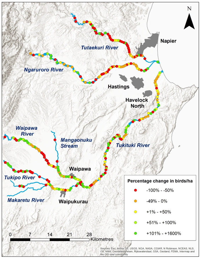
Figure 1: Percentage
change in the density of pohowera/banded dotterels counted per survey section
on the Tūtaekurī, Ngaruroro and Tukituki Rivers between 2019-2021
(pre-Cyclone Gabrielle) and 2023 (post-Cyclone Gabrielle).
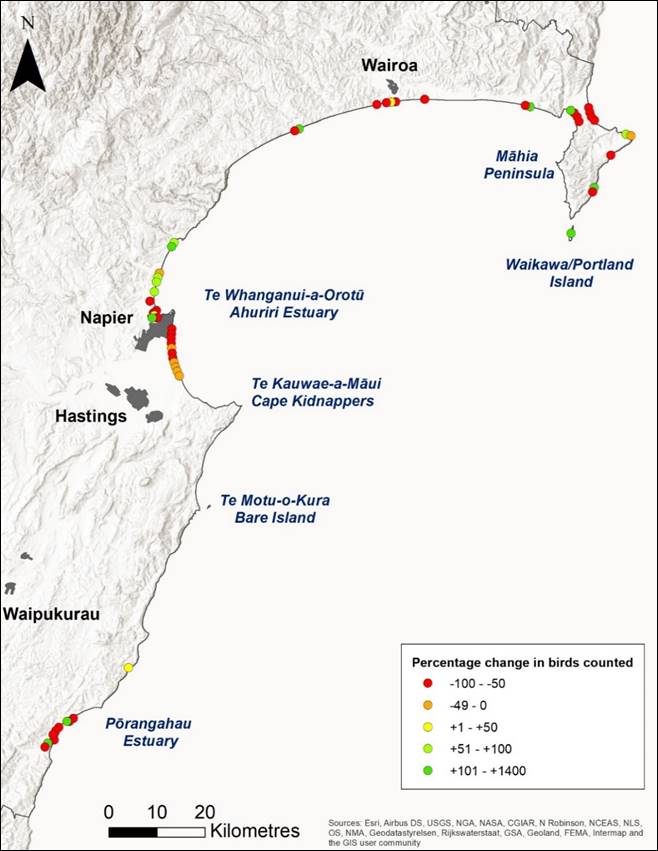
Figure 2: Percentage
change in the number of pohowera/banded dotterels counted per survey section
along the Hawke’s Bay coastline in 2021 (pre-Cyclone Gabrielle) and 2024
(post-Cyclone Gabrielle).
16. A total of 987 black-fronted
dotterels were counted in the three river catchments, representing a 30%
decline from the average of 1405 birds counted during the pre-cyclone surveys.
Black-fronted dotterel numbers declined by 38% on the Tūtaekurī
River, by 32% on the Ngaruroro and by 27% on the Tukituki River (Figure 3).
These are the steepest population declines to have been recorded in all three
of these catchments since these bird surveys began in 1962.
17. Black-fronted dotterels are
largely restricted to the riverbeds of Hawke’s Bay, so the 30% decline
observed on these rivers represents a 30% decline in the regional breeding
population of this species. It is not yet known whether this regional decline
has been caused by bird mortality due to inundation during the cyclone, or by
birds emigrating to other parts of New Zealand in response to a decline in
local habitat quality. If bird mortality is the cause, then this regional
decline of 30% is equivalent to a 15-17% decline in the national population of
this ‘At Risk’ species.
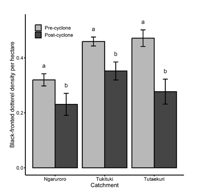
Figure 3: Black-fronted
dotterel densities (mean ± S.E.) in three Hawke’s Bay braided river
catchments before and after Cyclone Gabrielle. Different lowercase letters
indicate significant differences between pre- and post-cyclone surveys within
each catchment using post-hoc Tukey tests with Bonferroni correction (P <
0.05).
18. A total of 1327 poaka/pied
stilts were counted in all three river catchments during the 2023 post-cyclone
survey, representing a 16% decline from the average of 1573 birds counted
during the pre-cyclone surveys. Poaka/pied stilt numbers declined by 37% on the
Tūtaekurī River and by 24% on the Tukituki River but increased by 13%
on the Ngaruroro River. On the Hawke’s Bay coastline, a total of 1058
poaka/pied stilts were counted during the 2024 post-cyclone survey,
representing a 34% decline from the 1606 counted in 2021.
19. 26 tōrea/South Island pied
oystercatchers were counted, representing a 43% decline from the average of 46
birds counted during the pre-cyclone surveys. The Tūtaekurī,
Ngaruroro and Tukituki Rivers are the only locations in the North Island where
this species breeds, so this observed decline represents a 43% decline in the
North Island breeding population of this species.
20. Cyclone Gabrielle led to
substantial reductions in riverbed vegetation in all three river catchments,
and substantial increases in the percent cover of fine sediment. Lower levels
of vegetation cover were associated with higher local densities of pohowera/banded
dotterels, black-fronted dotterels and pied stilts, and a greater percent cover
of fine sediment was associated with higher local densities of pohowera/banded
dotterels (Figure 4).
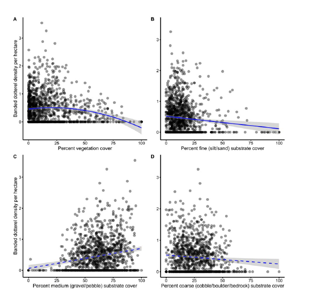
Figure 4: Relationships
between pohowera/banded dotterel density and the percent cover of riverbed
vegetation (A) and in fine (B), medium (C) and coarse (D) substrates on
Hawke’s Bay braided rivers. Solid and dashed lines represent significant
(P < 0.05) and non-significant relationships,
respectively.
21. There was significant variation
in cyclone impacts between different shorebird species inhabiting the
Hawke’s Bay coastline. Population sizes of a number of
‘Threatened’ or ‘At Risk’ species appear to have been
unaffected by Cyclone Gabrielle, with similar numbers of matuku moana/reef
herons, tōrea pango/variable oystercatchers, tarāpuka/black-billed
gulls, tara/white-fronted terns and pīhoioi/New Zealand pipit counted both
pre- and post-cyclone.
22. Several other
‘Threatened’ or ‘At Risk’ species do appear to have
been severely impacted however, notably kawau/black shag (40% decline), kāruhiruhi/pied
shag (42% decline), tūturiwhatu/New Zealand dotterel (36% decline),
pohowera/banded dotterel (31% decline) and tarāpunga/red-billed gull (17%
decline). Substantial declines were also observed for poaka/pied stilts (34%)
and karoro/black-backed gulls (19%), two native species assessed as ‘Not
Threatened.’ A 24% decline in kuihi/Canada geese and other introduced and
invasive species was also observed
23. Tūturiwhatu/New Zealand
dotterels declined by 36% from 222 birds counted in 2021 to 142 birds counted
in 2024, representing a dramatic reversal in population trend for a species
that had been increasing steadily in numbers since re-colonising the Hawke’s
Bay coastline in 1990. Local declines in tūturiwhatu/New Zealand dotterel
numbers were observed along the entire length of the Hawke’s Bay
coastline but appeared to be particularly severe at the mouths of the Wairoa
and Aropaoanui Rivers, Waipātiki Stream, as well as along the eastern
coastline of Māhia Peninsula, at Waitangi Estuary and at Pourerere and
Aramoana Beaches (Figure 5).
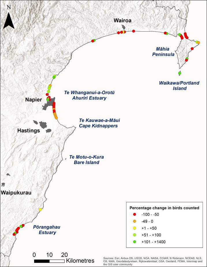
Figure 5: Percentage
change in the number of tūturiwhatu/New Zealand dotterels counted per survey
section along the Hawke’s Bay coastline in 2021 (pre-Cyclone Gabrielle
and 2024 (post-Cyclone Gabrielle).
24. The results of this survey
demonstrate for the first time that extreme weather events exacerbated by
human-induced climate change can lead to severe declines in shorebird
populations at catchment and regional scales in New Zealand. This in turn
provides the first empirical evidence that these species have a high degree of
vulnerability to the impacts of climate change. It is not yet clear however
whether these observed declines are a result of adult mortality, or a change in
bird distribution in response to declines in habitat quality. It is also not
yet known whether, or how quickly, these impacted bird populations will recover
from these declines.
Next steps
25. These results provide the first
empirical evidence collected in New Zealand that demonstrate the vulnerability
of these threatened, endemic shorebird species to climate-change driven extreme
weather events, and demonstrates for the first time that regional breeding
populations of these species can suffer significant declines as a result of
these weather events.
26. The severity of these declines
indicate that climate change adaptation plans need to include measures to
mitigate adverse impacts on our natural ecosystems. In the case of
Hawke’s Bay’s internationally and nationally significant
populations of riverbed and coastal-nesting shorebirds, mitigation could
include large-scale mammalian predator control to offset losses caused by
flooding, and the creation of artificial nesting habitats in less flood-prone
locations.
27. In the case of coastal
shorebirds, future changes in land-use and the construction of coastal defences
in response to the rising sea level need to be done in such a way as to avoid a
net loss of intertidal and foreshore habitats, as sea level rise causes
habitats to migrate inland.
28. It is recommended that a second
three-year series of river bird surveys be carried out between 2026 and 2029,
and that a third coastal bird survey be carried out during the summer of
2028-2029, to assess the degree to which riverbed and coastal shorebird
populations have recovered from the impacts of Cyclone Gabrielle.
29. Understanding whether, or how
quickly, these shorebird populations recover from these observed declines will
be crucial to further improving our understanding of the vulnerability of these
species to the impacts of extreme weather events exacerbated by human-induced
climate change. This improved understanding will in turn assist HBRC and other
authorities to make better-informed decisions regarding the measures required
to mitigate the impacts of climate change on these shorebird populations.
Decision-making considerations
30. Staff have
assessed the requirements of the Local Government Act 2002 in relation to this
item and have concluded that, as this report is for information only, the
decision-making provisions do not apply.
Recommendation
That the Māori Committee
receives and notes the Coastal and River Bird Survey findings staff
report.
Authored by:
|
Annabel
Beattie
Senior
Scientst - Terrestrial Ecology
|
Becky
Shanahan
Senior
Scientist Marine & Coasts
|
|
Louise van
Jaarsveldt
Environmental
Engineer
|
|
Approved by:
|
Iain Maxwell
Group
Manager Integrated Catchment Management
|
|
Attachment/s
There are no
attachments for this report.
HAWKE’S
BAY REGIONAL COUNCIL
Māori Committee
Wednesday 4 September 2024
Subject: North Island Weather Events flood resilience programme
Reason for report
1. This
item provides the Committee with information on the North Island Weather Events
(NIWE) Resilience Programme and Infrastructure Programme Management Office
(IPMO) and the current status of projects within the flood resilience programme
with respect to mana whenua engagement specifically.
Background
2. The Crown and
Hawke’s Bay Regional Council (HBRC) entered into the North Island Weather
Events (2023) – Hawke’s Bay Crown Funding Agreement on 10 October
2023 (the NIWE Agreement).
3. The NIWE Resilience
Programme consists of several initiatives to provide flood protection schemes
to multiple communities across Hawke’s Bay and it also incorporates
upgrades to both pumpstations and stopbanks associated with existing schemes,
as well as Telemetry upgrades and Scheme Reviews.
4. The packages of work
funded through this agreement are highlighted below.
|
Severely
Affected Land Areas
|
Crown
Funding
|
HBRC
Funding
|
Total
|
|
Wairoa
|
$70,000,000
|
|
$70,000,000
|
|
Pākōwhai
|
$70,676,470*
|
$23,373,530*
|
$94,050,000*
|
|
Whirinaki
|
|
Ohiti
|
|
Waiohiki
|
|
Pōrangahau
|
|
Sub
Total
|
|
$164,050,000
|
|
Pumpstation Upgrades
|
$22,544,329
|
$7,455,671
|
$30,000,000
|
|
Rapid Repair –
stopbank height increases
|
$22,544,329
|
$7,455,671
|
$30,000,000
|
|
Telemetry
|
$3,757,388
|
$1,242,612
|
$ 5,000,000
|
|
Scheme Reviews
|
$2,254,433
|
$745,567
|
$ 3,000,000
|
|
Total
|
$191,776,949
|
$40,273,051
|
$232,050,000
|
*For the purposed of this
table the value for Tangoio (now Cat 3) and Joll Road (to be delivered by HDC)
have been excluded from these values.
Delivering the programme
5. Hawke’s Bay
Regional Council’s Infrastructure Programme Management Office (IPMO) was
established in recognition of the significant step change in capital project
delivery that HBRC needs to deliver flood infrastructure across Hawke’s
Bay. This work includes NIWE (North Island Weather Event) flood mitigation
projects in the aftermath of Cyclone Gabrielle including:
5.1. Flood
mitigation projects for Waiohiki, Omahu, Whirinaki, Pākōwhai,
Pōrangahau, and Wairoa
5.2. Pump
station, Telemetry, other Stopbank upgrades and Scheme Reviews.
6. There is also a
portfolio of asset upgrade work that was underway before the cyclone hit, and
is delivered by the IPMO:
6.1. Water
security: managed aquifer recharge,
and water storage
6.2. Gravel
extraction from rivers and river treatments
6.3. Parks
and reserves: toilet blocks, ducting, power, non-potable water, parking, and
general upgrades.
7. The IPMO has a
dedicated Director (Jon Kingsford), Programme Management Office including
Finance and Controls Manager, Health and Safety Advisor, an Operations lead, a
Mana Whenua Engagement Facilitator, and a Comms and Engagement team, as well as
Project Management teams. The IPMO sits within the Regional Council’s
Asset Management Group, headed by Chris Dolley.
Mana whenua engagement in the
IPMO
8. The IPMO has
comprehensive mana whenua engagement framework and process documents –
both created to guide meaningful collaboration and partnership with mana whenua
in the delivery of works for the NIWE projects. This framework and process
acknowledges the unique perspectives, values, and mātauranga of mana
whenua and seeks to weave in mana whenua insights and aspirations into the
planning and implementation of the critical projects to be delivered by the
IPMO.
9. The mana whenua
engagement framework is designed to meet and exceed the requirements set out in
the Severe Weather Emergency Recovery Order 2024. The framework ensures early
identification and engagement with relevant mana whenua entities, facilitates
formal meetings, and promotes the establishment of working groups and
Memorandum of Understandings (MOUs). It incorporates the use of Cultural Impact
Assessments (CIAs) to assess cultural impacts and integrate mātauranga
Māori (traditional knowledge) into project planning. Furthermore, it
emphasises ongoing communication, capacity building, and cultural monitoring,
ensuring mana whenua are active participants throughout the project lifecycle.
10. MOUs have been
developed by the IPMO (Mana Whenua Engagement Facilitator) and are utilised
when engaging mana whenua in partnerships, to complete CIAs etc.
The NIWE Flood mitigation
projects
11. Each of the projects below has
a public project hub page housed on the HBRC website. The hubs house the latest
update on the project (usually the latest newsletter) and:
11.1. The
project timeline
11.2. Background
of the project
11.3. The
project team
11.4. Contact
details for enquiries (email, web form, phone numbers)
11.5. Archive
of previous newsletters
11.6. Archive
of meeting notes (from community meetings)
11.7. FAQs
(where applicable)
11.8. Useful
links (e.g. Insurance Council, relevant TA, financial and housing support etc).
Wairoa ($70m)
12. The largest of
the NIWE works programme to move 627 Category 2C properties to Category 1. Two
engineering solutions are tabled – stopbanks and spillway.
12.1. August: A Crown Manager, Lawrence Yule,
was appointed and discussions are underway as to how the engagement will be
handled. Sue Wilson has been employed on a contract basis as Engagement Advisor
based in Wairoa, and funding for a Wairoa-based Mana Whenua Engagement Advisor
has been received. Two preferred solutions have been recommended by the
Stakeholder Group to go to the Tripartite in early September.
12.2. The project working group will reconvene and
lead the oversight of the CIA delivery. In late August, Tātau Tātau o
te Wairoa has indicated that they will project manage the delivery of the CIA.
Whirinaki ($11.5m)
13. This project
ensures 38 Category 2C properties can move to Category 1. Engineering solutions
include raising SH2, new stopbanks, upgrades to existing stopbanks, and
upgraded culverts.
13.1. August: Petane Marae
will be leading the delivery of the CIA. Ongoing engagement with Petane Marae
who will progress with entering into an MOU. We are working closely with
representatives from Petane Marae on the ground.
Waiohiki ($10m)
14. This project
ensures 46 Category 2C properties can move to Category 1. The engineering
solution includes a new stopbank, stream alignment, and new drainage swales.
14.1. August: Ongoing
engagement with hapū representatives and project updates. An agreement
will be entered in to with the number of landowners for road access.
Ohiti Rd/Omāhu ($10m)
15. This project
ensures 11 Category 2C properties can move to Category 1. The engineering
solution includes stopbanks, stream works and drainage.
15.1. August: HBRC
met with representatives of Te Piringa hapū at the marae to discuss the
IRG programme work, Ohwia Stream work, and repairs to the stopbank. The
discussion also covered the Cultural Impact Assessment (CIA) and Memorandum of
Understanding (MOU). The scope of work for the CIA (IRG and Ohwia works) is
expected within the week following the meeting. Ongoing communication is taking
place regarding the MOU.
Pākōwhai ($50m)
16. This project
ensures 74 Category 2C properties can move to Category 1. Engineering solutions
include stopbank rebuilds, stream alignment, drainage, and overland flow
management.
16.1. August: Ongoing engagement with mana
whenua continues. A lead has been identified to write the Cultural Impact
Assessment (CIA) for Ngāti Hori, Ngāti Hawea, and Ngāti Hinemoa.
Another lead has been identified to manage the CIA for Waiohiki/Ngāti
Pārau. The scope of work has been sent to the writers for their review,
completion, and agreement. Ecological works are scheduled to start the week of
19 August. Kaitiaki from Waiohiki Marae and Waipatu Marae will assist and work
with the ecologists as they undertake assessments.
Pōrangahau ($13m)
17. This project ensures 138
Category 2A properties can move to Category 2C and then Category 1. Engineering
works will include stopbanks, sheetpiling, river management and drainage.
Pōrangahau is the last remaining community in 2A. Fortnightly update meetings
are held with CHBDC.
17.1. August:
Ongoing communication with Ngāti Kere and
Rongomaraeroa Marae has led to a request for a joint MOU to strengthen
our partnership as part of these works. This agreement will be progressed
quickly.
|
Project
|
Proposed
and/or confirmed solution
|
Timeframe
|
Mana
Whenua Engagement Lead
|
Hapū
| Marae
|
PSGE
|
|
Omāhu | Ohiti
Flood Mitigation
|
New stopbank
|
Start summer 2024-2025
Approx six month
delivery
|
Te Kaha Hawaikirangi
|
Te Piringa Hapū
|
Omāhu | Ohiti
Flood Mitigation
|
|
Whirinaki Flood
Mitigation
|
New stopbank
|
Start mid-2025 tbc
|
Jack Smith-Ballingall
|
Petane Marae
|
Whirinaki Flood
Mitigation
|
|
Wairoa Flood Mitigation
|
New stopbank and/or
floodway
|
TBC
|
Nathan Heath and Te
Wairama Munro
|
Tātau Tātau o
Te Wairoa
Tawhiti a Maru Marae
Takitumu Marae
Ruataniwha Marae
|
Wairoa Flood Mitigation
|
|
Pōrangahau Flood
Mitigation
|
New stopbank
|
Late 2025
Approx six month
delivery
|
Te Kaha Hawaikirangi
|
Rongomaraearoa Marae
Ngāti Kere
Hapū Authority
|
Pōrangahau Flood
Mitigation
|
|
Waiohiki Flood
Mitigation
|
New stopbank
|
Summer 2024
Approx six month
delivery
|
Te Kaha Hawaikirangi
(although not engaged in MOU or scope)
|
Waiohiki Marae
Ngāti Parau
Hapū Trust
|
Waiohiki Flood
Mitigation
|
|
Pākōwhai
Flood Mitigation
|
New stopbank
|
Late 2025
Approx six month
delivery
|
Te Kaha Hawaikirangi
(although not engaged in MOU or scope)
|
Ngāti Hawea
Ngāti Hori
Ngāti Hinemoa
|
Pākōwhai
Flood Mitigation
|
|
Tūtaekuri Cultural
Values Assessment
|
|
Complete by end 2024
|
Te Kaha Hawaikirangi
(although not engaged in MOU or scope)
|
Moteo Marae
Wharerangi Marae
Timikara Marae
Waiohiki Marae
|
Tūtaekuri Cultural
Values Assessment
|
|
Ngāuroro Cultural
Values Assessment
|
|
Complete by end 2024
|
Anthony Tipene-Matua
and Te Kaha Hawaikirangi
|
Te Piringa Hapū
Tamatea Pōkai
Whenua
Taiwhenua o Heretaunga
|
Ngāuroro Cultural
Values Assessment
|
Pump stations
18. Pākōwhai –
Progress has been made in identifying key contacts from Kohupatiki Marae for
the Farndon Rd and Pākōwhai pump station Cultural Impact Assessment
(CIA), and a writer has been selected. The draft scope of work has been sent
for completion. A meeting was held on 20 August to advance the CIA and MOU.
19. Awatoto – Ngāti
Pārau Hapū Trust has identified a key contact and selected a writer
for the Cultural Impact Assessment (CIA) for this project.
20. Brookfields– Ngāti
Pārau Hapū Trust has identified a key contact and selected a writer
for the Cultural Impact Assessment (CIA) for this project.
Asset Management Group BAU projects (administered and delivery by the IPMO)
21. Tūtaekurī CVA – Ongoing collaboration with Mana Ahuriri Trust in
developing this document. The work is progressing well, with the estimated
completion targeted for the end of the year. Regular updates and wānanga
are being held with hapū.
22. Ngāuroro CVA– The plan is progressing well and is currently in its final
draft stage, it is currently under review with TPH. An interim report has been
submitted further and revisions are expected before finalising the document.
23. Farndon Road– Progress
has been made in identifying key contacts from Kohupatiki Marae for the Farndon
Rd and Pākōwhai pump station Cultural Impact Assessment (CIA), and a
writer has been selected. The draft scope of work has been sent for completion.
A meeting was held on 20 August to advance the CIA and MOU.
24. Omaranui stopbank upgrade– Ongoing engagement with the Moteo Marae and Ngāti
Pārau Hapū representatives is underway for the Cultural Impact
Assessment (CIA) related to this work.
25. Maraenui Golf Course– Ngāti Pārau Hapū Trust has identified a key
contact and selected a writer for the Cultural Impact Assessment (CIA).
26. Moteo– Ongoing
engagement with the Moteo Marae representative is underway for the Cultural
Impact Assessment (CIA) related to this work.
27. East Clive Tukituki– The chairperson of Matahiwi Marae has been in contact with
the relevant party, and a writer has been identified for the Cultural Impact
Assessment (CIA). The scope of work has been sent for review. A meeting is
scheduled onsite for 20 August to progress the CIA.
28. Raupare Upper and Chesterhope Upper – HBRC met with representatives of Te Piringa
Hapū at the marae to discuss the BAU programme of work, Ohiwia Stream
work, and repairs to the stopbank. The discussion also covered the Cultural
Impact Assessment (CIA) and Memorandum of Understanding (MOU). The scope of
work for the CIA (BAU and Ohiwia works) is expected within the week following
the meeting. Ongoing communication is taking place regarding the MOU.
29. Brookfield Lower– Ngāti Pārau Hapū Trust has identified a key
contact and selected a writer for the Cultural Impact Assessment (CIA).
30. Pākōwhai Park, Raupare Lower– No engagement has started yet; this has been
raised with the relevant party. However, there are plans to engage a suitable
candidate to discuss undertaking this CIA, as they are leading the CIA in
Pākōwhai.
31. Ohiwia Stream works– HBRC met with representatives of Te Piringa Hapū at
the marae to discuss the BAU programme of work, Ohiwia Stream work, and repairs
to the stopbank. The discussion also covered the Cultural Impact Assessment
(CIA) and Memorandum of Understanding (MOU). The scope of work for the CIA (BAU
and Ohiwia works) is expected within the week following the meeting. Ongoing
communication is taking place regarding the MOU.
What the next six months look
like
32. The
IPMO will continue to prioritise the delivery of key flood resilience projects
and we will continue working in partnership with mana whenua, hapū, and
marae, undertaking CIAs and entering into MOUs to support resourcing and
capability. We remain committed to upholding our mana whenua engagement
framework, ensuring that the voices and perspectives of mana whenua are
integral to our project planning and implementation processes.
33. To
maintain transparency and foster continued collaboration, we propose providing
the HBRC Māori Committee with regular updates on the progress of these
projects. We are open to discussing the preferred format and frequency of these
updates, whether through monthly reports, dedicated project updates, or regular
briefings at future committee meetings.
34. Your
feedback is crucial to ensuring that our approach aligns with the expectations
and needs of the Māori Committee. We look forward to your guidance on how
best to keep you informed and engaged as we move forward.
Decision-making considerations
35. Staff
have assessed the requirements of the Local Government Act 2002 in relation to
this item and have concluded that, as this report is for information only, the
decision-making provisions do not apply.
Recommendation
That the Māori Committee receives and notes the North
Island Weather Events flood resilience programme staff report.
Authored by:
|
Jess Bennett
Programme
Finance & Controls Manager
|
Sarah Cameron
Team
Leader - IPMO Communications & Engagement
|
|
Te Kaha
Hawaikirangi
Kaihautū
Pūtaiao - Mātauranga Māori
|
Jon Kingsford
Manager
Regional Projects
|
Approved by:
|
Chris Dolley
Group
Manager Asset Management
|
|
Attachment/s
There are no
attachments for this report.
HAWKE’S BAY REGIONAL COUNCIL
Māori Committee
Wednesday 4 September 2024
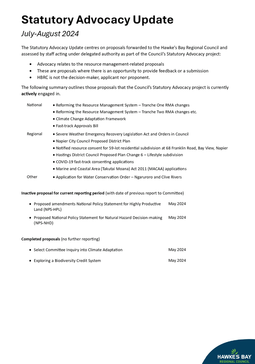
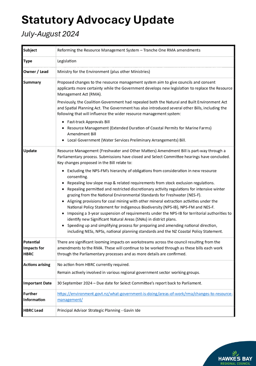
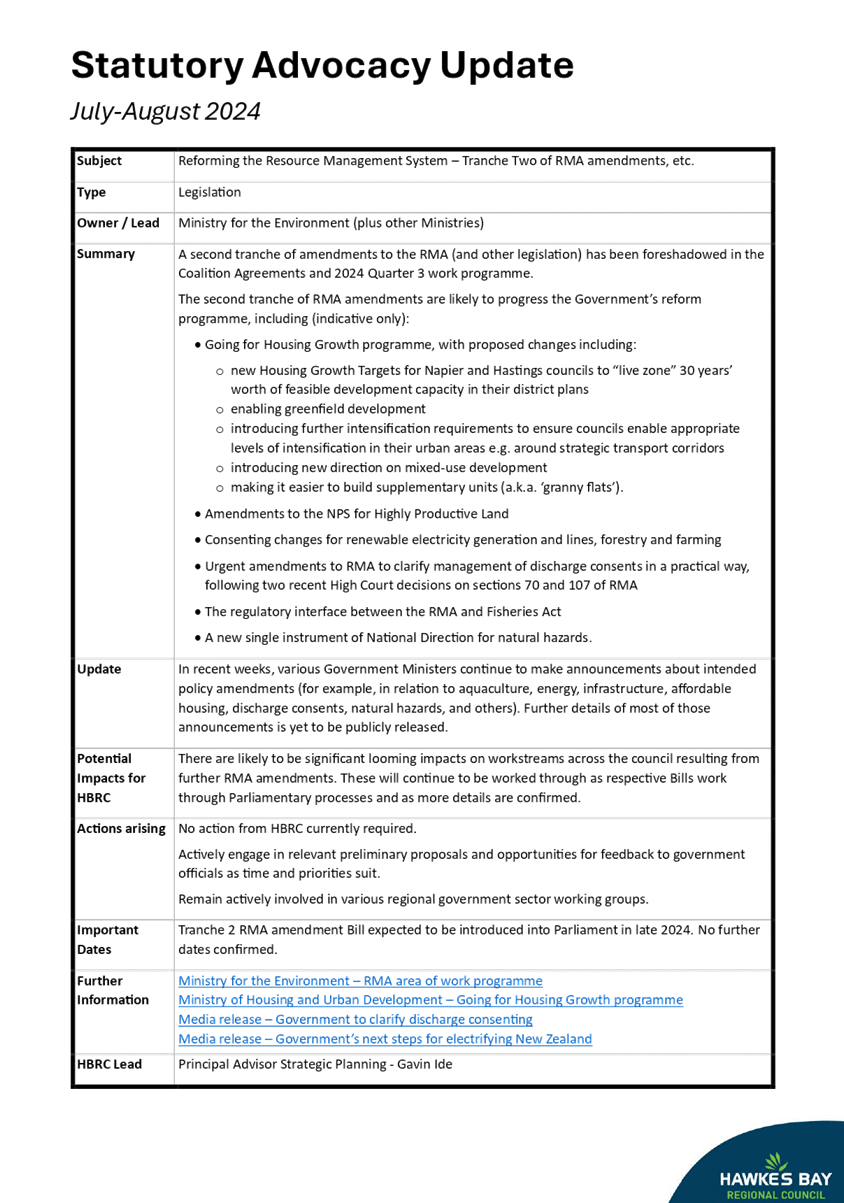
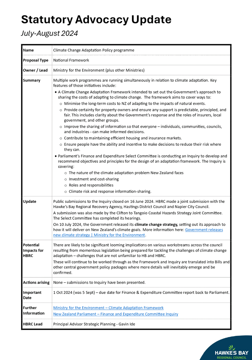
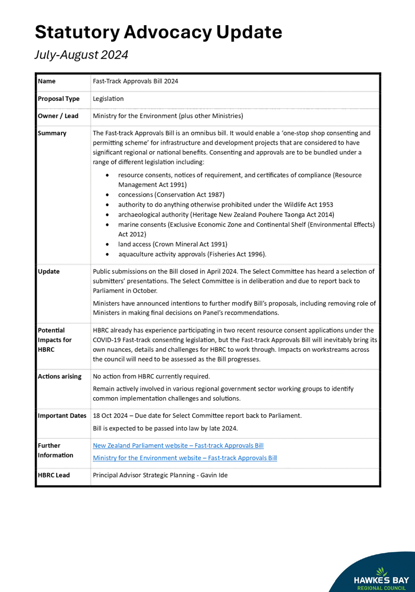
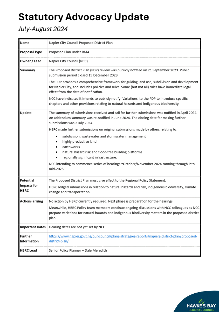
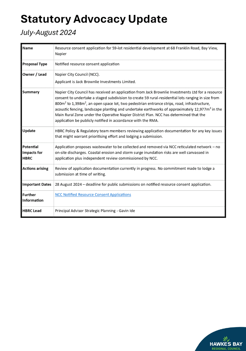
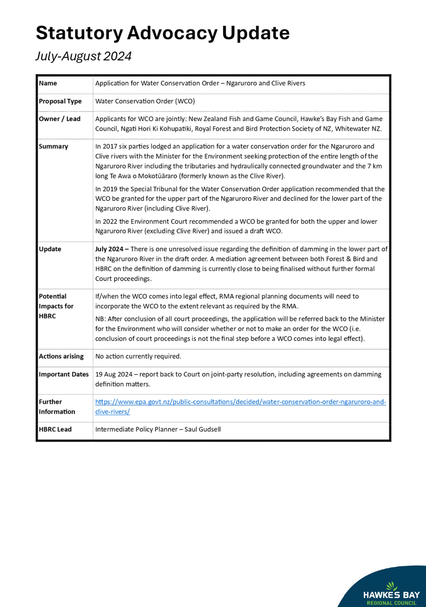
Subject: September 2024 Statutory Advocacy and Resource Management
reform update
Reason
for Report
1. This
item updates the status of reports on proposals forwarded to the Regional
Council and assessed by staff acting under delegated authority as part of the
Council’s Statutory Advocacy project. This edition features a new-look
style. And feedback on this new style is invited.
2. The
Statutory Advocacy project centres on local resource management-related
proposals upon which the Regional Council has an opportunity to make comments
or to lodge a submission. These include, but are not limited to:
2.1. resource
consent applications publicly notified by a territorial authority
2.2. reviews
and changes to district plans overseen by a territorial authority
2.3. non-statutory
strategies, structure plans, registrations, etc prepared by territorial
authorities, government ministries or other agencies involved in resource
management.
3. From
time to time, the Statutory Advocacy project also coordinates the Regional
Council’s feedback on resource management-related proposals from central
government agencies such as Ministry for the Environment, Ministry for Primary
Industries and Parliamentary Committees etc.
4. In
all cases, the Regional Council is not the decision-maker,
applicant nor proponent.
5. Copies
of formal submissions made by the Regional Council on resource
management-related proposals can be viewed online at www.hbrc.govt.nz (keyword #hbrcsubmissions).
Decision-making process
6. Staff
have assessed the requirements of the Local Government Act 2002 in relation to
this item and have concluded that, as this report is for information only, the
decision-making provisions do not apply.
Recommendation
That the Māori Committee receives and notes the September
2024 Statutory Advocacy and Resource Management reform update.
Authored by:
|
Gavin Ide
Principal
Advisor Strategic Planning
|
Nichola
Nicholson
Acting
Manager Policy & Planning
|
Approved by:
|
Katrina
Brunton
Group
Manager Policy & Regulation
|
|
Attachment/s
|
1⇩
|
Statutory
Advocacy Update July-August 2024
|
|
|
|
Statutory
Advocacy Update July-August 2024
|
Attachment 1
|