Meeting of the
Environment and Integrated Catchments Committee
Date: 6 July 2022
Time: 11.30am
|
Venue:
|
Council
Chamber
Hawke's
Bay Regional Council
159
Dalton Street
NAPIER
|
Agenda
Item Title Page
1. Welcome/Karakia/Apologies
2. Conflict
of Interest Declarations
3. Confirmation of Minutes of
the Environment and Integrated Catchments Committee meeting held on 11 May 2022
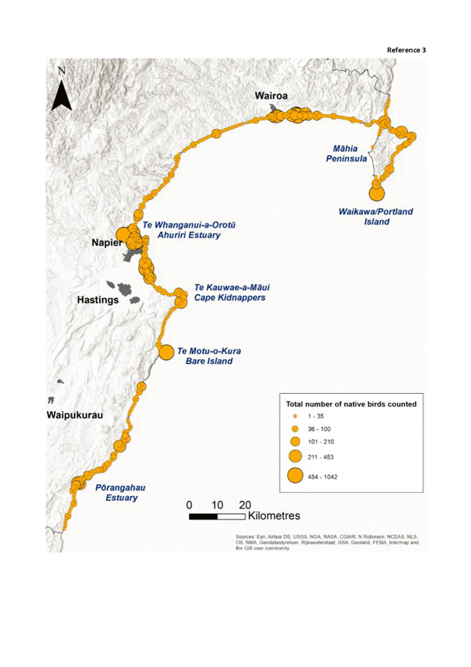
4. Follow-ups
from previous Environment and Integrated Catchments Committee meetings 3
5. Call
for Minor Items Not on the Agenda 7
Decision
Items
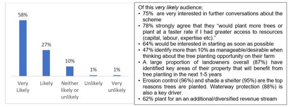
6. Ahuriri
Regional Park development framework 9
7. State
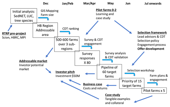
of Our Environment 3-yearly Synthesis Report 31
8. Reshaping
of the Protection and Enhancement Programme 35
Information
or Performance Monitoring
9. Organisational
Ecology by Dr Edgar Burns 41
10. Regenerative
agriculture research project 43
11. Right
Tree Right Place: Year 1 Report and Year 2 Programme 45
12. March/April
2022 double rain events – Flood scheme impacts, recovery and lessons
learned 57
13. Gravel
Extraction - current situation and new global consent 77
14. Karamu
Urban Catchment Advisor 83
15. Catchment
Engagement framework for policy implementation 89
16. Deer
Management 97
17. Discussion
of minor items not on the Agenda 105
Hawke’s Bay Regional
Council
Environment
and Integrated Catchments Committee
6 July
2022
Subject: Follow-ups from
previous Environment and Integrated Catchments Committee meetings
Reason for Report
1. On the list attached are
items raised at previous Environment and Integrated Catchments Committee
meetings that staff have followed up on. All items indicate who is responsible
for follow up, and a brief status comment. Once the items have been reported to
the Committee they will be removed from the list.
Decision Making Process
2. Staff have assessed the
requirements of the Local Government Act 2002 in relation to this item and have
concluded that, as this report is for information only, the decision-making
provisions do not apply.
Recommendation
That the Environment and
Integrated Catchments Committee receives and notes the Follow-ups from
previous Environment and Integrated Catchments Committee meetings.
Authored by:
|
Annelie Roets
Governance Advisor
|
|
Approved by:
|
Chris Dolley
Group Manager Asset Management
|
Iain Maxwell
Group Manager Integrated Catchment
Management
|
Attachment/s
|
1⇩
|
Follow-ups from previous Environment
and Integrated Catchments Committee meetings
|
|
|
|
Follow-ups from previous Environment and
Integrated Catchments Committee meetings
|
Attachment
1
|
Hawke’s
Bay Regional Council
Environment
and Integrated Catchments Committee
6 July
2022
Subject: Call for minor items not on
the Agenda
Reason
for Report
1. This item provides the
means for committee members to raise minor matters relating to the general business of
the meeting
they wish to bring to the attention of the meeting.
2. Hawke’s Bay Regional
Council standing order 9.13
states:
2.1. “A meeting may discuss an
item that is not on the agenda only if it is a minor matter relating to the
general business of the meeting and the Chairperson explains at the beginning
of the public part of the meeting that the item will be discussed. However, the
meeting may not make a resolution, decision, or recommendation about the item,
except to refer it to a subsequent meeting for further discussion.”
Recommendations
That the Environment and Integrated
Catchments Committee accepts the following Minor items not on the Agenda
for discussion as item 17.
|
Leeanne
Hooper
Governance
Team Leader
|
James
Palmer
Chief
Executive
|
Hawke’s Bay Regional
Council
Environment
and Integrated Catchments Committee
6 July
2022
Subject:
Ahuriri Regional Park development framework
Reason for Report
1. This item seeks the
Committee’s recommendations to the Regional Council for the establishment
of a joint committee to provide governance guidance and oversight for the
development of Ahuriri Regional Park.
Officers’
Recommendations
2. Regional Council staff
recommend that the Committee reviews and considers the information provided
about the establishment of the Ahuriri Regional Park Joint Committee and
provides feedback, including on the proposed Terms of Reference, to enable
Council’s agreement to establish the joint committee.
Background
/Discussion
3. The Ahuriri Regional Park
Working Group (ARPWG) was formed in June 2020 to develop a concept that was
identified in Napier City Council’s Ahuriri Estuary and Coastal Edge
Masterplan (2018) into a project suitable for funding via the Long Term Plan
(LTP). This Working Group consisted of members from Napier City Council (NCC)
and Hawke’s Bay Regional Council (HBRC), and worked closely with the yet
to be formalised Te Komiti Muriwai o te Whanga (Te Komiti) to ensure the
project was consistent with the vision set by Te Komiti to deliver enhancements
to biodiversity, ecosystems, water quality, and cultural values for the
estuary.
4. At the NCC Future Napier
Committee meeting on 11 November 2021, the Committee considered a paper from
the ARPWG and resolved, in relation to the Ahuriri Regional Park, to:
4.1. Endorse that the future
park to be located at Lagoon Farm be a platform for climate resilience and city
sustainability, delivering flood mitigation, stormwater quality, biodiversity
and estuarine restoration.
4.2. Endorse that the boundary
of the park currently known as the Ahuriri Regional Park be confined to the
legal boundaries of Lagoon Farm (Lot 1 DP 388211).
4.3. Endorse the preparation of
a masterplan for the park currently known as the Ahuriri Regional Park and the
appointment of an independent project manager.
4.4. Endorse officers exploring
options for project governance structures for the purpose of endorsing a draft
masterplan (including a multi-party Regional Committee), for consultation to be
brought back for Council consideration next year.
5. With funding being
allocated in both NCC and HBRC’s LTPs for this project, it is now desirable
to establish an appropriate governance structure to support the next phase of
the project.
Options
6. On 14 February 2022,
representatives of HBRC and NCC met with Mana Ahuriri Trust with the intention
of entering into a three-way partnership to progress this project. Options for
a governance structure were considered, including:
6.1. Joint Committee
6.2. Working Group
6.3. 50/50 ownership.
7. Although there are pros and
cons for each option, the ARPWG considered a joint committee (JC) structure
offers the following benefits:
7.1. Provides a vehicle for true
co-governance of the project.
7.2. JC is able to make
recommendations to each partner for decision-making.
7.3. Provides greater formality
for decision-making via established decision-making processes of each partner.
7.4. Use of JC structure has a
proven success record with, for example, the Clifton to Tangoio Coastal Hazards
Strategy and Hawke’s Bay Drinking Water Governance joint committees.
8. The options available to
the Regional Council are to:
8.1. Agree to establish the
Ahuriri Regional Park Joint Committee in partnership with Napier City Council
and Mana Ahuriri Trust, including:
8.1.1. Adopting the proposed Terms
of Reference (either as proposed or with immaterial amendments proposed for
subsequent agreement by NCC and MAT)
8.1.2. Appointing councillors
Hinewai Ormsby and Neil Kirton as the HBRC-nominated Joint Committee members,
and Councillor Martin Williams as the alternate (or appointing alternative JC members).
8.2. Agree to establish the
Ahuriri Regional Park Joint Committee subject to agreement by Napier City
Council and Mana Ahuriri Trust to:
8.2.1. Include additional parties
as members of the joint committee
8.2.2. Make material amendments to
the Terms of Reference as agreed by EICC today.
8.3. Not agree to establish a
Joint Committee for the Ahuriri Regional Park project.
Development
of the preferred option
9. The Ahuriri Regional Park
Working Group (ARPWG) was established to progress the project to the point of
receiving funding in the councils’ Long Term Plans. Now that this
milestone has been reached, options for the governance of the project through
its next phase have been considered by the ARPWG, with a Joint Committee being
determined as the most appropriate, and an invitation extended to Mana Ahuriri
Trust to be equal partners.
10. The Terms of Reference
(ToR) establish the ‘rules of engagement’ and expectations for each
party. The ToR is based on the Clifton to Tangoio Coastal Hazards Strategy
Joint Committee, and has been through a number of iterations with the Working
Group and Mana Ahuriri Trust nominees. The proposed ToR has also received legal
review by NCC, with the conclusion that the establishment of this Joint
Committee is provided for in the Local Government Act 2002, and there is
precedent for it.
11. Councillor Hinewai Ormsby
has co-chaired the Ahuriri Regional Park Working Group alongside NCC Councillor
Annette Brosnan. Councillors Neil Kirton and Martin Williams have also been involved
as members of the Working Group. Nominating these HBRC representatives to form
part of the Joint Committee is intended to ensure continuation of governance
oversight from the inception phase through to the project’s planning
phase.
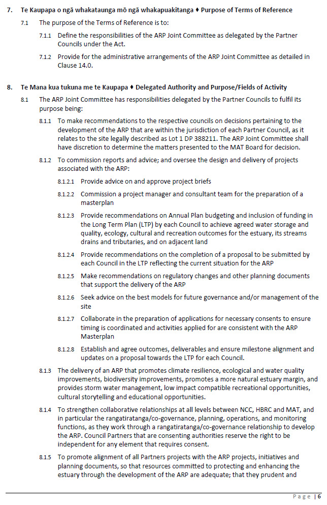
12. The purpose of the Terms of
Reference) is to define the responsibilities of the JC as delegated by the
partner councils (NCC and HBRC) under the Local Government Act, and to provide
for the administrative arrangements of the JC. The ToR establishes:
12.1. the number of JC members
from each partner
12.2. the purpose of the JC and
its decision-making delegations
12.3. how the JC will work
alongside Te Komiti Muriwai o te Whanga
12.4. matters relating to
administrative support, including meetings, voting, remuneration, leadership,
and reporting.
13. It is proposed that the JC
is made up of two elected members each representing NCC and HBRC, and four
members from Mana Ahuriri Trust. Each partner entity is also invited to
nominate one alternate representative. This represents a true and equal
partnership between the councils and Mana Whenua.
14. Mana Ahuriri Trust Board
will be considering a similar paper to adopt the Terms of Reference on 30 June
2022, and has nominated their members, who are:
14.1. Tania Eden
14.2. Allana Hiha
14.3. Chad Tareha
14.4. Maree Brown
14.5. an alternate yet to be
decided.
15. The two elected members
nominated by the NCC Future of Napier Committee on 16 June 2022 are
councillors Annette Brosnan and Keith Price, and Councillor Hayley Browne as
alternate.
16. The two elected members
recommended to be nominated to represent HBRC are councillors Hinewai Ormsby
and Neil Kirton, and Councillor Martin Williams as the alternate.
Issues
17. Currently Lagoon Farm is in
freehold title and solely owned and managed by NCC. It has been earmarked
for future stormwater detention for the City. Entering into a partnership of
this nature will mean that future development of this site may be significantly
influenced by Ahuriri Regional Park JC recommendations. The purpose of the JC
is to make recommendations, with decisions still lying with each Partner where
these have the delegated power to do so.
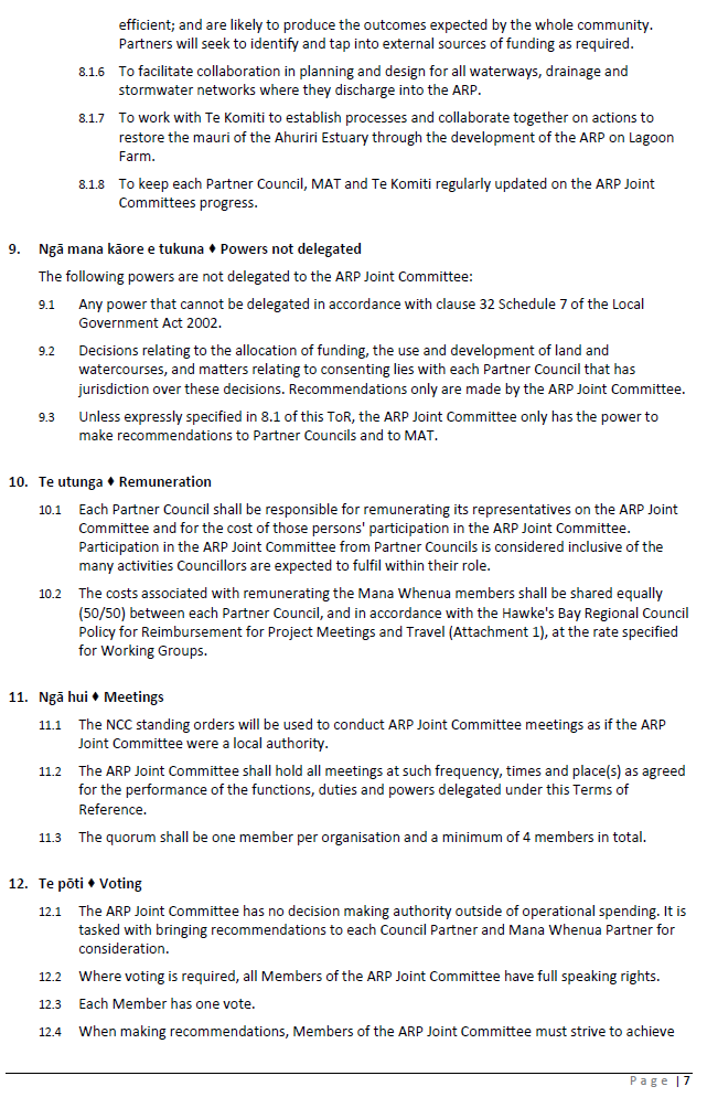
18. Parties to the JC may seek
to make changes to the ToR as they move through the process of approving them.
The resolution of the Future of Napier Committee was:
18.1. Approve in principle the
Terms of Reference for the Ahuriri Regional Park Joint Committee (Doc Id
1471630), allowing for minor inconsequential changes being made by each partner
as required
19. If the Regional Council approves the
proposed ToR in principle, allowing for minor, inconsequential changes to be
made, then the ToR can proceed unhindered. However, if the Regional Council
requests more substantial changes, the ToR will need to be referred back to
both NCC and MAT for agreement prior to proceeding, and require further
consideration and resolution at a future Regional Council meeting.
20. Legal advice sought by NCC
on the ToR concluded that, on balance, the Local Government Act 2002 provides
for the ability to form a JC with both Council partners and mana whenua
entities, and that there is precedent in doing so. Clarity on the powers
delegated to the JC (and those that aren’t) is essential for ensuring
clear expectations from all parties, and the ToR has been drafted accordingly.
Significance
and Engagement Policy Assessment
21. All Partners acknowledge
that there are a significant number of stakeholders in the establishment of an
Ahuriri Regional Park, and that the project team, once established, will work
closely with these stakeholders throughout the course of the project and
beyond. As noted in the Joint Committee Terms of Reference, the Project
Manager, once appointed, will report to Napier City Council and its Partners on
a regular basis in relation to the project itself.
22. The NCC Significance and
Engagement Policy provides clarity on how and when the community can expect to
be engaged, depending on the degree of significance of the issue, proposal and
decision. The formation of a Joint Committee and its accompanying ToR do not
meet the criteria under this Policy for consultation.
23. The NCC Policy further
states that while Lagoon Farm is not listed as a Strategic Asset, decisions
made in relation to the future use and development of the property may have a
high level of community interest. In addition, should part of the property be
used as an integral part of the city’s stormwater network (e.g. retention
areas) in the future, then this would be classed as a strategic asset and may
require public consultation.
24. It is worth noting that the
concept of the Ahuriri Regional Park has already been through both of the NCC
and HBRC LTP public consultation processes.
Financial
and Resource Implications
25. NCC is the Council that
will facilitate the Joint Committee under its policies and processes
26. The Terms of Reference
specifies a 50/50 NCC HBRC split of costs associated with remunerating the Mana
Whenua partners to the Joint Committee.
27. The HBRC Council Meetings
Remuneration Policy is applicable to the remuneration of non-elected Council
officials. NCC does not have an applicable policy, and so the ToR adopts the
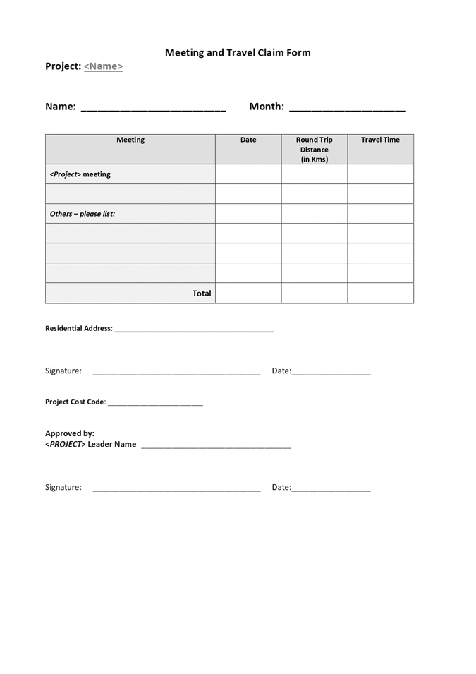
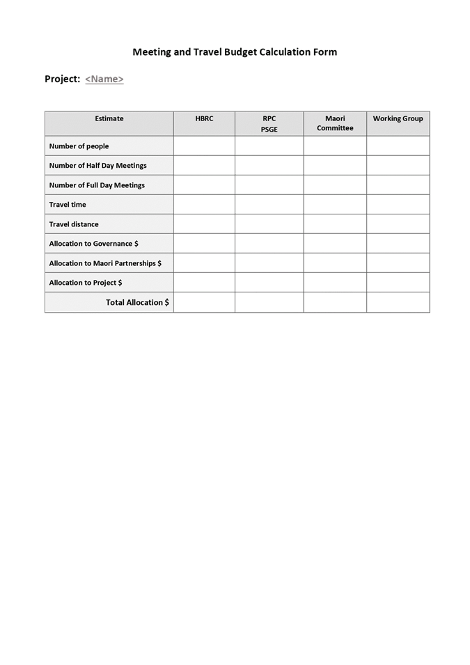
HBRC Policy. A copy of the HBRC Policy for Reimbursement for Project Meetings
and Travel is attached.
Social
& Policy
28. The Ahuriri Estuary and
Coastal Edge Masterplan (NCC) identified the exploration of the regional park
concept for Lagoon Farm, including stormwater management and enhancement of
biodiversity and cultural values, as an initiative of priority. The concept
gained significant support from stakeholders and the wider public. It was clear
early on that partnership with Te Komiti Muriwai o te Whanga was essential as
the project would be a significant contributor to delivering on the purpose of
Te Komiti, and the masterplan would operate alongside Te Muriwai o te Whanga
Plan for the wider estuary catchment. Co-governance with HBRC and Mana Ahuriri
Trust is a commitment to working collaboratively from the very outset and at
all levels.
Risks
29. As noted above, the primary
risk is in relation to entering into an equal partnership with both NCC and MAT
in a manner that the JC can make recommendations on the future use and
development of a Napier City Council-owned asset. It is noted however, that the
ToR afford the power for the JC to make recommendations only, and that the
decision-making power still lies with each Council and the MAT Board in terms
of their respective interests.
Opportunities
30. The risks of establishing a
Joint Committee for the Ahuriri Regional Park project cannot be considered
without also highlighting the opportunities. This project, and the governance
structure established to guide and support it, is an opportunity to tangibly
work in partnership toward common goals on a project that will benefit
everyone. There will no doubt be challenges along the way that will test the
resolve of the partnership, but each Partner has committed to working through
these in good faith, and as a result there is significant opportunity to
strengthen our ties and reach out to all corners of the community to deliver
what will be a legacy project for the region.
Other Considerations
31. As with all committees, the
Ahuriri Regional Park Joint Committee (ARPJC) will be discharged at the end of
September 2022 ahead of the local elections and subsequently re-established by
agreement between Napier City and Hawke’s Bay Regional councils as part
of their new 2022-2024 governance structures.
32. Alternatively, NCC and HBRC
could each resolve that the ARPJC is not discharged under LGA Schedule 7 s30(7)
and that replacement members for each of the councils will be appointed
following the election. In this case, mana whenua members’ membership
would be unaffected.
Decision Making Process
33. Council and its committees
are required to make every decision in accordance with the requirements of the
Local Government Act 2002 (the Act). Staff have assessed the requirements in
relation to this item and have concluded:
33.1. The decision does not
significantly alter the service provision or affect a strategic asset, nor is
it inconsistent with an existing policy or plan.
33.2. The use of the special
consultative procedure is not prescribed by legislation.
33.3. The decision is not
significant under the criteria contained in Council’s adopted
Significance and Engagement Policy.
33.4. The establishment of a
Joint Committee is provided for by LGA clause 30(1)(b).
33.5. Given the nature and
significance of the issue to be considered and decided, and also the persons
likely to be affected by, or have an interest in the decisions made, Council
can exercise its discretion and make a decision without consulting directly
with the community or others
having an interest in the decision.
Recommendations
1. That the Environment and
Integrated Catchments Committee receives and considers the Ahuriri Regional
Park development framework staff report.
2. The Environment and
Integrated Catchments Committee recommends that Hawke’s Bay Regional Council:
2.1. Agrees that the decisions
to be made are not significant under the criteria contained in Council’s
adopted Significance and Engagement Policy, and that Council can exercise its
discretion and make decisions on this issue without conferring directly with
the community or persons likely to have an interest in the decision.
2.2. Agrees to the establishment
of the Ahuriri Regional Park Joint Committee
2.3. Adopts the Terms of
Reference as proposed, allowing only for minor immaterial changes
2.4. Appoints councillors
Hinewai Ormsby and Neil Kirton as the Regional Council’s Joint Committee
representatives, and Councillor Martin Williams as the alternate.
Authored & Approved by:
|
Chris Dolley
Group Manager Asset Management
|
|
Attachment/s
|
1⇩
|
Ahuriri Regional Park Joint
Committee Terms of Reference
|
|
|
|
2⇩
|
Policy for Reimbursement for Project
Meetings and Travel
|
|
|
|
Ahuriri Regional Park Joint Committee
Terms of Reference
|
Attachment
1
|
|
Policy for Reimbursement for Project Meetings and Travel
|
Attachment
2
|
Hawke’s Bay Regional
Council
Environment
and Integrated Catchments Committee
6 July
2022
Subject:
State of Our Environment 3-yearly Synthesis Report
Reason for Report
1. This item presents the Hawke’s
Bay State of our Environment 2018-2021 Report. This report gives an
overview of the state of the Hawke’s Bay environment, including
biodiversity and ecosystem health, climate, our coast, and air and water
quality.
2. Staff will deliver a
presentation of the key highlights of this report for:
2.1. Climate and Air
2.2. The Wairoa/Northern Coast
Catchments
2.3. The Mohaka Catchment
2.4. The Esk and Central Coast
Catchments
2.5. The Tūtaekurī,
Ahuriri, Ngaruroro and Karamū Catchments
2.6. The Tukituki Catchment
2.7. The Pōrangahau and
Southern Coast Catchments
Officers’
Recommendation
3. Staff recommend that the
report is adopted for publication.
Executive
Summary
4. Delivery of the State of
the Environment report is required by the Resource Management Act at no less
than 5 yearly intervals.
5. This report describes the
state of our natural resources and provides an evidence basis to support
decision making for the wider organisation and Council.
Background
/Discussion
6. State of the Environment
(SoE) reporting provides an environmental scorecard and assessment for
Hawke’s Bay Regional Council, communities and stakeholders to identify
and evaluate environmental conditions and pressures throughout the
Hawke’s Bay region.
7. In the time since the
publication of the previous SoE report for Hawke’s Bay (2013-2018),
central government has raised the bar for assessment and reporting. In
particular, the Essential Freshwater package was adopted in 2020 and includes
amendments to the National Policy Statement for Freshwater Management (NPS-FM).
The NPS-FM requires regional councils to report on the extent to which
long-term visions for the environment have been achieved, along with whether
the NPS-FM requirements have been met.
8. The NPS-FM also requires
information on environmental pressures, causes of issues, actions to address
issues, and an ecosystem health scorecard. Scorecard reports must also be
written in a way that “members of the public are likely to understand
easily.”
9. This SoE report takes a
different direction to previous reports for the Hawke’s Bay region by
aiming to be less technical than previous SoE reports, reporting at both
regional and catchment scales, providing greater context on environmental
pressures and restoration actions throughout the Hawke’s Bay region, and
adopting a more integrated ki uta, ki tai approach by considering interactions
among land, water, ecosystems, and receiving environments.
10. This report will be
particularly relevant for informing Kotahi dialogue alongside changes to the
Regional Resource Management Plan (RRMP) and Regional Coastal Environment Plan
(RCEP), which promotes the sustainable and integrated management of
Hawke’s Bay land, water and coastal resources.
11. The report is designed as
independent chapters based by topics or place. Topics include:
11.1. Regional biodiversity
(chapter 2)
11.2. Regional air quality
(chapter 3)
11.3. Regional climate (chapter
4)
11.4. Braided rivers (chapter 5)
11.5. Regional groundwater
quantity (chapter 6)
11.6. Regional groundwater
quality (chapter 7)
11.7. Regional river flows
(chapter 8)
11.8. Regional ecosystem health
(chapter 9)
11.9. Regional sediment story
(chapter 10)
11.10. Regional nitrogen story (chapter 11)
11.11. Regional phosphorus story (chapter 12)
11.12. Human health and recreational (chapter
13)
11.13. Regional marine and coast (chapter
14).
12. Place-based land and water
sections include:
12.1. The Wairoa/Northern Coast
Catchments (chapter 15)
12.2. The Mohaka Catchment
(chapter 16)
12.3. The Esk and Central Coast
Catchments (chapter 17)
12.4. The Tūtaekurī,
Ahuriri, Ngaruroro and Karamū Catchments (chapter 18)
12.5. The Tukituki Catchment
(chapter 19)
12.6. The Pōrangahau and
Southern Coast Catchments (chapter 20).
13. Authoring staff will
present a summary of the report to Council that explains the key
messages. The report will then be released as an online-only publication.
Strategic Fit
14. The SOE report provides an
evidential basis for measuring success of HBRC’s strategic goals.
15. It aligns with HBRC’s
priority areas of:
15.1. Water quality, safety and
climate-resilient security
15.2. Climate-smart and
sustainable land use
15.3. Healthy functioning and
climate-resilient biodiversity
15.4. Sustainable and
climate-resilient services and infrastructure.
Significance
and Engagement Policy Assessment
16. The decision is not
significant under the criteria contained in Council’s adopted
Significance and Engagement Policy.
17. The SOE report will be
shared with the public once adopted by Council.
Other Considerations
18. Due to the extent of
material covered in the SOE report and the limited time to present it in a
committee meeting, staff will be available to attend an All Governors hui to
workshop the material at a later date.
Decision Making Process
19. Council and its committees
are required to make every decision in accordance with the requirements of the
Local Government Act 2002 (the Act). Staff have assessed the requirements in
relation to this item and have concluded:
19.1. The decision does not
significantly alter the service provision or affect a strategic asset, nor is
it inconsistent with an existing policy or plan.
19.2. The use of the special
consultative procedure is not prescribed by legislation.
19.3. The decision is not
significant under the criteria contained in Council’s adopted
Significance and Engagement Policy.
19.4. The persons affected by
this decision are all persons with an interest in the region’s management
of natural and physical resources under the RMA
19.5. Given the nature and
significance of the issue to be considered and decided, and also the persons
likely to be affected by, or have an interest in the decisions made, Council
can exercise its discretion and make a decision without consulting directly
with the community or others
having an interest in the decision.
Recommendations
1. That the Environment and
Integrated Catchments Committee receives and considers the Hawke’s Bay
State of Our Environment Report 2018-2021.
2. The Environment and
Integrated Catchments Committee recommends that Hawke’s Bay Regional
Council:
2.1. Agrees that the decisions
to be made are not significant under the criteria contained in Council’s
adopted Significance and Engagement Policy, and that Council can exercise its
discretion and make decisions on this issue without conferring directly with
the community or persons likely to have an interest in the decision.
2.2. Adopts the Hawke’s Bay State of
Our Environment Report 2018-2021 for publication.
Authored by:
|
Anna Madarasz-Smith
Manager Science
|
|
Approved by:
|
Iain Maxwell
Group Manager Integrated Catchment
Management
|
|
Attachment/s
|
1
|
2018-2021 State of the Environment
Report
|
|
Under Separate Cover
|
Hawke’s
Bay Regional Council
Environment
and Integrated Catchments Committee
6 July
2022
Subject: Reshaping of the Protection
and Enhancement Programme
Reason for Report
1. This item seeks the
Environment and Integrated Catchments Committee’s recommendation to
Council to change the delivery model for the Protection and Enhancement
Programme (PEP) to include a contestable community Environmental Enhancement
Fund along with an expansion of our Targeted Catchment Work Programme.
Executive
Summary
2. A review was undertaken of
the delivery of the $1M PEP projects, assessing the spend of internal staff
time relative to the money spent on physical on-ground project delivery while
also evaluating how other Regional Councils' are implementing similar
environmental funds.
3. The key recommendation from
the review was that HBRC should no longer seek to lead projects in the
Protection and Enhancement space but instead, look to support and facilitate
organised landowners and/or community groups to deliver environmental projects
throughout the region that meet our strategic objectives.
4. This will allow HBRC
greater flexibility to increase the delivery of significant environmental
projects that are not currently eligible for funding through our existing
programs. This addresses a community need and will also improve synergy between
ICM funding programmes.
5. Therefore, it is proposed
that the $1M allocated to the PEP be split into two fund categories:
Environmental Enhancement Fund (EEF) and Targeted Catchment Work (TCW) - with
the implementation of these set to begin in the 2022-2023 financial year.
Background
/Discussion
6. In 2017 as part of
the Annual Plan development, the PEP (formerly Environmental Hot Spots)
was established to accelerate on-ground action on six identified
high-priority environmental 'hot spots' throughout the region – Ahuriri
Estuary, Karamu River, Lake Tūtira, Lake Whakakī, Tukituki
River, Lake Whatumā and our Marine environment.
7. These initiatives were
proposed with a focus on leveraging the Ministry for the Environment’s
Freshwater Improvement Fund (FIF). HBRC was successful in gaining funding for Tūtira (Te
Waiū o Tūtira, a 4-year project 2018 - 2022) and
Whakakī (sunshine, wetlands and bees will revitalise the taonga
of Whakakī, a 5-year project 2019 - 2024).
8. Over the past 5 years, the
PEP has enabled HBRC to build important relationships and work with
stakeholders and Treaty partners to deliver a significant volume of on-ground
work. This has been implemented at the catchment/sub-catchment scale to
initiate the long-term restoration of these key ecosystems through enhancing
biodiversity and water quality.
9. However,
numerous issues have been experienced throughout the duration of
the Tūtira and
Whakakī FIF projects that have
impacted the ability to successfully deliver the projects’ full
sets of objectives. These issues have primarily revolved around relationship
management with key stakeholders and the inability to obtain unanimous approval
to complete some of the more ambitious project objectives.
10. Ultimately, this resulted
in HBRC having to hold/carry forward significant funding that was attached to
these projects over several years without the flexibility to redirect funding
to other opportunities as they arose. HBRC also invested considerable staff
resources to obtain resolutions for the issues affecting these projects.
11. During the same timefame,
the ICM Group implemented the Erosion Control Scheme and funded Priority
Ecosystem site restoration work throughout the region. The successful delivery
of these programmes has highlighted additional areas of work not being
addressed through our existing funding programmes that could be targeted
through the PEP.
12. There has been sustained
growth in the interest and awareness of the environmental issues we are facing
across the region. This has come from a diverse cross-section of the community many
of whom are wanting to take ownership and lead the delivery of projects to
contribute to the restoration of the regions environment.
13. This has driven an
increased demand for funding from a wide range of people/groups/agencies who
are motivated to achieve outcomes in line with HBRC’s strategic focus.
14. A review was undertaken to
consider how money has flowed across the PEP projects and the amount of
internal staff time spent relative to the money spent on physical project
delivery, while also evaluating how other Regional Councils' are implementing
similar environmental funds.
15. This highlighted that many
other Regional Councils across the motu were operating an annual contestable
fund to support community and catchment groups to deliver environmental
enhancement and biodiversity projects.
Options
Assessment
16. As a result of the review,
the following core principles were developed as a recommendation to provide
clear guidance for the future of the PEP.
17. HBRC will no longer seek to
lead projects in the protection and enhancement space but, instead, look to
support and facilitate organised landowners and/or community groups to deliver
environmental projects throughout the region that meet our strategic
objectives.
18. This allows HBRC more
flexibility to target the delivery of significant environmental projects that
are not currently eligible for funding through our existing programmes. This
not only addresses a community need and will also improve synergy between ICM
funding programmes and increase region-wide delivery of environmental outcomes.
19. Community and catchment-led
groups have an increasingly crucial role to play in the future improvement and
management of the region's environment. A key aspect of the PEP will be to
build/strengthen key relationships with external groups and support them to
build capacity and capability in the delivery of environmental projects.
20. Moving forward it is
proposed that the PEP has two fund categories: Environmental Enhancement
Fund and Targeted Catchment Work. Both are outlined below with the
implementation of these set to begin in the 2022-2023 financial year:
Environmental
Enhancement Fund
|
Fund Category
|
Detail
|
Budget
|
|
Environmental
Enhancement Fund
|
This is a contestable fund available to established
Catchment and Community Groups. Providing these groups, with a model for
successful project delivery. Allowing them to build capacity to seek funding
from other external sources.
Assessment criteria are based on our strategic
objectives and level of service statements and measures. Projects can be up
to two years and applicants can apply for further funding once the previous
project has been delivered.
Annual funding round with the applications evaluated by
a dedicated HBRC staff panel.
|
$100k p.a.
Pilot for the first 3 years
Min. $5k per
project
Max. $25k
per project
|
21. The following
groups/organisations would be eligible to apply for funding through the EEF:
21.1. Community groups
21.2. Iwi/hapu
21.3. Kaitiaki groups
21.4. Incorporated societies
21.5. Community trusts
21.6. Resident and ratepayer
groups
21.7. Landowner groups (e.g.
Landcare or Streamcare groups)
21.8. Tertiary education
institutions
21.9. Businesses and industries.
22. Projects for the EEF would
be assessed by the following criteria.
22.1. Applications of up to a
maximum of $25,000 ex GST.
22.2. Projects that encourage appropriate
public access to the project site.
22.3. Projects/activities within
Hawke’s Bay Regional Council’s legal boundaries and areas of
responsibility.
22.4. Fit with Hawke’s Bay
Regional Council’s strategic outcomes and policies – how the
project contributes to Council’s LTP outcomes.
22.5. Environmental protection
and enhancement – is there a clear need for the project, and how the
project will directly promote, enhance or protect the region’s
environment.
22.6. Community participation
& awareness – how the project involves iwi Māori, the wider
community and increases public awareness of environmental issues.
22.7. Value to Mana Whenua
– how the project involves iwi Māori including their cultural
values, interests and associations, the effect on Māori historic heritage
or the relationship of Māori and their culture and traditions with their
ancestral lands, water, sites, wāhi tapu and other taonga including fauna
and flora.
22.8. Viability – the
likelihood of the project’s success and the applicant’s capability
to deliver the outcomes of the project. Desirable attributes include a robust
project plan, a project budget providing visibility of all funding sources for
the project and a clear method for monitoring the success of the project.
22.9. Budget - does the project
represent value for money and is the project suitably allocated to achieve the
desired outcomes.
23. In the majority of cases,
HBRC expects funding to be released via advanced partial payment (up to 80% of
the total project value) rather than upon project completion. This is due to
the fact the majority of the community/catchment groups are in their infancy
and not expected to be holding significant finances to operate via payment in
arrears.
24. Advanced partial payment
has shown to be the most common approach taken by other Regional Councils in
the implementation of community funds. However, there is a level of financial
risk associated with releasing funding via advanced partial payment. To
mitigate this the maximum project value has been capped at $25,000.
Targeted
Catchment Work fund
|
Fund Category
|
Detail
|
Budget
|
|
Targeted Catchment Work
|
Targeted Catchment Projects
The purpose of this fund is to deliver high-value
environmental outcomes on a catchment/sub-catchment scale such as improved
water quality, riparian protection, biodiversity enhancement, wetland
development.
The place-based constraints that were established with
the original Hotspot fund will be removed to allow greater regional flexibility
in the delivery of this programme.
Target areas where we have established good
relationships with landowners to provide further subsidies for work that
falls outside the eligibility of the ECS/EP funds but substantially
contribute to the delivery of our strategic outcomes and in turn provide a
good return on investment.
Can be multi-year projects, with a 60% subsidy with
landowners.
Internal Targeted Projects
A portion of this fund (up to 100k p.a.) will be
available for cross-council investment to partner for specialised projects
that have strong environmental outcomes, innovation and build key external
relationships such as the proposed Inanga Enhancement Programme, eDNA
Monitoring Programme etc.
|
$500k p.a.
HBRC Min. $2K per project
HBRC Max. $30K per project
|
|
Marine Protection and Enhancement Project
This is a continuation of the existing Marine
Protection and Enhancement Project. Funding is dedicated to investment in our
scientific understanding of our marine environment and
systems. Supporting the delivery of work including multibeam echo-sounding
surveys of the seabed; sediment surveys of Hawke’s Bay to provide
modelling, and fencing and planting to protect the remnant seagrass beds.
|
$200k p.a.
|
|
Staff cost and overheads
|
The annual cost of the Programme Manager Protection and
Enhancement Fund is covered by the fund.
|
$200k
p.a.
|
25. The primary aim of the TCW
is to assist on-ground works and actions by providing advice and assistance in
programme development and implementation.
26. Project plans will be
developed in partnership with HBRC Catchment Delivery staff and on-ground works
delivered through a subsidy scheme (60% HBRC 40% Landowner/Catchment Group) to
projects that protect and enhance our freshwater and land resources.
27. The fund has been designed
to complement the Erosion Control Scheme and the Priority Ecosystem Programme
by covering works and activities that do not meet their funding criteria but
will contribute to significant environmental improvements and meet our existing
strategic outcomes.
28. A comprehensive approach
will be taken to target on-ground environmental enhancement activities with
projects being able to cover multiple properties at the sub-catchment or
catchment scale.
29. Project eligibility for the
TCW would be determined by the following criteria:
29.1. Projects must address one
or more of the following: erosion prevention, biodiversity enhancement,
ecosystem restoration, improvement in water quality, stream, or wetland habitat
creation or improvement, plant/animal pest management.
29.2. Projects must contribute to
high-value environmental outcomes at a catchment or sub-catchment scale.
29.3. Applicants must provide a
40% funding match in the form of cash, labour, and/or donated materials.
29.4. Projects must be within the
Hawke’s Bay regional boundary. If the project is applied for by a
‘group’, landowners whose land the project covers must provide
written approval.
29.5. Project length and size are
not limited but will be subject to annual funding availability.
29.6. Project goals can overlap
with ECS and PEP projects.
30. Examples of projects that
would be delivered through the TCW would include but not be limited to the
following:
30.1. Riparian and streambank
stabilization, retirement and enhancement (planting, pest control) –
where not required by legislation.
30.2. Wetland restoration or
development.
30.3. Plantation to permanent
forest cover conversion.
30.4. Phosphorus/sediment detainment
bund establishment.
30.5. Retirement and native
forest reversion.
Strategic Fit
31. Due to this being a new
approach for delivering the PEP, there is currently no Level of Service
Statements (LOSS) or Levels of Service Measures (LOSM) attached to the programme. However, specific LOSM will be developed
at the next point of review.
32. Notwithstanding this, the proposed changes
to the PEP outlined in this report
align with Council’s strategic plan, priority areas and associated
objectives for sustainable land use, biodiversity and water quality. This
report seeks to streamline the delivery of the fund allowing for increased
delivery in those priority areas.
Significance and Engagement Policy Assessment
33. This matter is not
significant, as defined in Council’s significance and engagement
policy. The PEP and associated funding is already included in
Council’s 2021-2031 Long Term Plan.
Considerations of Tangata Whenua
34. There are no specific
considerations required in relation to the request made in this report as this
merely seeks to alter the method of delivery for the existing fund.
Financial and Resource Implications
35. The $1M funding for the PEP
is already included in Council’s 2021-2031 LTP. This report seeks to gain
approval to reallocate this funding to implement the changed approach to
delivery outlined above.
36. The implementation of both
the EEF and TCW will provide a detailed understanding of the resources required
to deliver these funds at a larger scale. Staff will then be in a position to
engage Council on potentially expanding the value of the funds and staff
resources through the next LTP process.
Decision Making Process
37. Council and its committees
are required to make every decision in accordance with the requirements of the
Local Government Act 2002 (the Act). Staff have assessed the requirements in
relation to this item and have concluded:
37.1. The decision does not
significantly alter the service provision or affect a strategic asset, nor is
it inconsistent with an existing policy or plan.
37.2. The use of the special
consultative procedure is not prescribed by legislation.
37.3. The decision is not
significant under the criteria contained in Council’s adopted
Significance and Engagement Policy.
37.4. The persons affected by
this decision all those persons with an interest in the region’s
management of natural and physical resources.
37.5. Given the nature and
significance of the issue to be considered and decided, and also the persons
likely to be affected by, or have an interest in the decisions made, Council
can exercise its discretion and make a decision without consulting directly
with the community or others
having an interest in the decision.
Recommendations
That Environment and Integrated
Catchments Committe:
1. Receives and considers the Reshaping of the Protection
and Enhancement Programme staff
report.
2. Agrees that the decisions
to be made are not significant under the criteria contained in Council’s
adopted Significance and Engagement Policy, and that Council can exercise its
discretion and make decisions on this issue without conferring directly with
the community or persons likely to have an interest in the decision.
3. Approves the request to
implement the new delivery model for the Protection and Enhancement Programme.
Authored by:
|
Thomas Petrie
Programme Manager Protection &
Enhancement Projects
|
Jolene Townshend
Acting Manager Catchment Delivery
|
Approved by:
|
Iain Maxwell
Group Manager Integrated Catchment
Management
|
|
Attachment/s
There are no attachments for this
report.
Hawke’s Bay Regional
Council
Environment
and Integrated Catchments Committee
6 July
2022
Subject:
Organisational Ecology by Dr Edgar Burns
Reason for Report
1. This item introduces Dr
Edgar Burns’ report titled Organisational Ecology, which uses the concept of
organisational ecology to reflect on HBRC’s environmental work in our
region so we can increase our effectiveness in supporting improved environmental
practices and climate change readiness. This is the third social science report
for the Environment and Integrated Catchments Committee (EICC) in the technical
paper series.
Executive Summary
2. Selected examples and
issues of organisational ecology are discussed that can be used to enhance HBRC
delivery of its regional mandate for water soil and the growing climate
pressures faced both locally and globally.
3. This report brings a social
science lens to the HBRC role using the idea of organisational ecology to show
the complexity and opportunities of regional council work. Among many
organisational, community and sector groupings there are competing
understandings and interests. Within this ecology, only a small part of needed
changes are able to be influenced by HBRC.
Strategic Fit
4. This work delivers against 2020-25
Strategic Plan, namely that Climate change is at the heart of everything we
do.
Discussion
5. The HBRC is increasingly
faced with people pressures that interact with what science evidence is
reporting. While climate change denialism is receding, there is little
appreciation yet of the speed or severity of local consequences of climate
heating on this region and its inhabitants.
6. This is presented in the
main body of Dr Edgar Burns’ Organisational Ecology report, from the contents
page onwards.
7. Dr Burns will present the
findings of his research to Council and will be available for questions and
discussion.
Next Steps
8. Selected next steps are
proposed in the final section of Dr Burns’ report (attached).
Decision Making Process
9. Staff have assessed the
requirements of the Local Government Act 2002 in relation to this item and have
concluded that, as this report is for information only, the decision-making provisions
do not apply.
Recommendation
That the Environment and Integrated Catchments
Committee receives and notes the Organisational Ecology report by Dr
Edgar Burns.
Authored & Approved by:
|
Iain Maxwell
Group Manager Integrated Catchment Management
|
|
Attachment/s
|
1
|
HBRC's Organisational Ecology
|
|
Under Separate Cover
|
Hawke’s
Bay Regional Council
Environment
and Integrated Catchments Committee
6 July
2022
Subject: Regenerative agriculture research project
Reason for Report
1. This item presents a
collaborative Regenerative Agriculture research project involving AgFirst, the
Regional Council, Ministry for Primary Industries and On-Farm Research.
Executive Summary
2. Lochie McGillivray
(AgFirst) and Dr Paul Muir (On-Farm Research) will present an oral summary of a
study to investigate the impacts of regenerative agriculture within a dryland
farming operation.
3. This project aims to
improve the resilience of sheep and beef farmers in a drought prone region.
This will be achieved by testing forage types and grazing management strategies
that meet the principles and practices of a Regenerative Agriculture system.
4. However, resilience is not
just about forages and forage management, it is also about stock policy and
timely decision making. To this end the project will set up a demonstration
unit where farmers can view and then mimic the systems deployed.
5. A wrap-around extension
programme will include system economic analysis, workshops and be focused on
the demonstration farm practices with regular farm walks.
Strategic
6. This topic considers
matters that align with Councils interests in:
6.1. Smart sustainable land use
6.2. Water quality safety and
security
6.3. Healthy functioning
biodiversity
6.4. Climate adaptation and
mitigation.
Background
7. Council is investing $100K
per year for four years to support a farmlet scale study of regenerative
agriculture through the Innovations and Strategic Relationships (ISR) grant
fund that is associated with the Erosion Control Scheme. The total budget
for the project is $2.5M. This represents significant leverage into a
greater understanding of a type of farm management that has significant
potential to help Council with its ambitions in land, water, biodiversity and
climate resilience management.
8. A greater understanding of
the potential benefits of regenerative agriculture will also assist in
understanding how best to integrate this into a farming system as part of the
Right Tree Right Place collaboration with The Nature Conservancy.
9. The ISR fund has been
created to provide financial support for initiatives and
partnerships/relationships that progress the aims of the scheme within the
Hawke’s Bay region. The key objectives that the aims to achieve
are:
9.1. Reducing soil erosion
9.2. Improving water quality
through the reduction of sedimentation into the waterways
9.3. Improving terrestrial and
aquatic biodiversity through habitat protection and creation; and
9.4. Providing community and
cultural benefits through forest ecosystem services.
10. Staff are involved in both
the technical working groups and project governance.
11. Co-investors in the project
include MPI, Barenbrug NZ Seeds, Beef and Lamb NZ and Ravensdown.
12. The research will be
undertaken at the Poukawa Research farm which is well established, with over 35
years of data and research on Hawkes Bay dryland agriculture, and with the
facilities to undertake the component research and farmlet studies required for
this project. The site is in the heart of Hawkes Bay dryland and its highly variable
rainfall (range 460 – 990 mm) means it is an ideal demonstration site for
this project.
Discussion
13. Lochie and Paul will
present to Council details on the research and some initial findings.
Decision Making Process
14. Staff have assessed the
requirements of the Local Government Act 2002 in relation to this item and have
concluded that, as this report is for information only, the decision making
provisions do not apply.
Recommendation
That the Environment and Integrated Catchments
Committee receives and notes the Regenerative Agriculture research project report
and presentation.
Authored & Approved by:
|
Iain Maxwell
Group Manager Integrated Catchment
Management
|
|
Attachment/s
There are no attachments for this
report.
Hawke’s
Bay Regional Council
Environment
and Integrated Catchments Committee
6 July
2022
Subject:
Right Tree Right Place: Year 1 Report and Year 2 Programme
Reason for Report
1. This item
provides the Committee with a summary of the progress from the last year of the
Right Tree Right Place (RTRP) project and outlines the current status and
high-level pathway for year two of the project.
Executive Summary
2. Work with initial pilot
farms was aimed at developing momentum for the project and to provide learning
for subsequent phases of the project. The first seedlings will be planted on
the first pilot farm this July and farm/forestry planning has started on the
second pilot farm. Legal and tax advice is supporting the development of
commercial arrangements for HBRC finance.
3. A recent farm survey about
perceptions of the RTRP model has shown high interest from respondents (58%
very likely to use RTRP). Survey results are supporting the prioritisation of
potential pilot farms, development of farm planning collateral and forward work
programme.
4. Developing the pipeline of
target RTRP farms has taken a structured approach with support from the
Catchment Delivery Team (CDT). The pipeline of potential farms will be used in
the business case for impact investment in the scale-up initiative.
5. A farm-planning framework
has been developed with support from lead consultants. Standardised templates
will allow information collected from farms to be used with business case
development.
6. There has been a solid
uptake of early communications about the project. Initial seedling planting and
survey results will be the subject of current comms. Landowner engagement has
now focused on priority farms in northern Hawke’s Bay catchment areas.
7. The forward work programme
will see the remaining farm/forestry plans and pilot farm selection take place
over the remainder of 2022. Impact investment business case development and
investor sounding will continue into the first half of 2023.
Project objectives
8. During the 2021-31 LTP
process, Council agreed to fund the RTRP project to address the significant
erosion problem in Hawke’s Bay through demonstrating a successful RTRP
model by refining a planting model with several objectives:
8.1. To recover its own costs
8.2. Encourage planting of trees
on erodible land
8.3. Stimulate the market to
invest in trees on farms that strengthens financial and environmental outcomes
8.4. Reducing the need for whole
farm afforestation
8.5. Plant enough trees to
prepare for climate change
8.6. Significant environmental
benefits.
RTRP
Pilot Farms
9. The early focus with pilot
farms has been to gather momentum quickly with the project in order to
incorporate the learning from the initial pilot farms into the forward work
programme. This approach will see planting on an initial pilot farm in this
planting season. It also allows a more considered approach with the remaining
pilot farms that aligns with due diligent efforts needed to underpin the
business case to scale up the RTRP concept.
10. An illustration of timing
relating to the pilot farms is shown below.
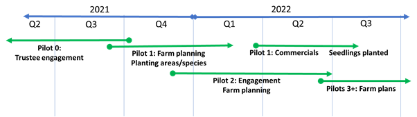
Pilot
farm 0: Ruakituri
11. A farm and forestry plan
were developed for a 1200 ha farm in the Ruakituri district in northern
Hawke’s Bay as part of the RTRP business case development. This farm was
to be the first pilot farm. The farm/forestry plan identified circa 140ha of
production Pinus Radiata, 23 ha of production redwoods and 54 ha of infill
native planting.
12. Presentations were made to
trustees of the farm, comprising the farm owners, their adult children and farm
advisors. The children preferred to proceed with implementing the RTRP
initiative as outlined in the farm/forestry planning exercise, in part, to
leverage additional revenues from forestry to facilitate succession of
ownership.
13. The older generation farm
owners were not comfortable with the risks associated with production forestry
and opted to proceed with a slower implementation of redwood and native
plantings.
14. This exercise did not
result in a HBRC funded RTRP initiative. However, it did result in trees being planted
on marginal and erodible land, the primary objective of RTRP.
15. Learning from this exercise
include:
15.1. It’s a big decision
for landowners to embark on forestry options at scale, and considerable time
and energy can be expended working with complex ownership structures that may
not result in a council-financed RTRP project.
15.2. Good quality farm/forestry
plans are needed to allow evidence-based decision making but it still takes
time to build confidence to embark on a forestry journey.
15.3. Ultimately, the vision that
the landowner has for their land needs to be the primary direction of travel.
15.4. Once evidence-based
material has been developed, landowners may develop the confidence to secure
alternative (non-HBRC) sources of capital to progress with forestry options or
fund planting out of cashflow over a longer timeframe.
15.5. There are challenges in
seedling supply, especially for natives, with lead times currently in the order
of two to three years.
Pilot
farm 1: Waipapa
16. Waipapa is a 724ha farm
located approximately 45km south of Hastings in Elsthorpe district.

17. The project worked with
landowners at Waipapa to develop a farm/forestry plan through the second half
of 2021. A memorandum of understanding was developed in early 2022 with ongoing
activity to confirm tree species options and a five-year planting plan.
18. The resulting work
recommends a mix of tree species including native trees and shrubs, Cedrus
deodara (Coastal Redwood), and Pinus radiata. Initial seedlings are
to be planted in July 2022. The total planting area amounts to just over 90ha
with half planted in P.radiata and costs to establish of approximately
$470,000.
19. Legal and tax advice is
being procured to develop HBRC funding options modeled on a loan with repayment
of principle and interest from carbon revenues over about 10 years. The loan
options are secured by a Forestry Right or mortgage over land for the period of
the loan. The HBRC finance team is supporting this work.
20. Lessons and leverage from
this pilot project:
20.1. A reasonable proportion of
pines (and faster growing species) are needed to subsidise native planting.
20.2. Detailed farm/forestry
plans involving on-farm walk-overs are needed to carefully refine planting and
fencing areas, species selection, pest control and a multi-year planting
programme.
20.3. Incorporating forestry and
additional revenue streams into a pasture-based farming system provides
considerable optionality for farm management: for example, selling forestry
blocks to a neighbour or shared infrastructure, and farm management options.
20.4. Low productivity land can
also be high maintenance land: transitioning this to forestry can reduce farm
workload and free up resources to focus on productive parts of the farm or
other non-farming pursuits.
20.5. A forestry initiative on
one farm can facilitate discussions with neighbouring farms about catchment
orientated initiatives to improve environmental outcomes at catchment scale.
20.6. Forestry supports
ecological outcomes, and this dimension should be considered when selecting
tree species: in the case of Waipapa, planting kōwhai will support
migration of tūī.
Pilot
farm 2: Coastal Central Hawke’s Bay
21. Development of a
farm/forestry plan has begun for a 1,300ha coastal property southeast of
Elsthorpe. Farm trustees have an interest in extension work and ,accordingly,
the property offers good potential for case-study development and
educational-collateral development.
22. The farm offers a clean
canvas on which to develop a forestry plan and potential to pre-plan
infrastructure like roading, fencing and other facilities.
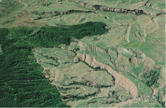
23. There are significant areas
of highly erodible land, both coastal and adjacent to waterways that will
require lateral thinking around species selection and mixed species planting
regimes. The Trust has a vision for increasing the current 60 ha of production
forestry to further plantings of production forestry and to invigorate native
regeneration.
Farmer survey
24. A farmer survey was
conducted in late 2021 to understand farmer sentiment of the RTRP concept,
interest and knowledge about planting trees and financing preferences,
knowledge and use of regenerative agricultural practises, and interest in
further discussions with the RTRP team.
25. This information is being
used to shape the future work programme, particularly in the area of landowner
engagement, farm planning processes, pilot farm selection and collateral needed
to support the programme.
26. The survey was launched in
February/March 2022 and fronted by CDT members who personally circulated the
survey and followed up directly with landowners.
27. The results were collated
and analysed in April/May and have recently been used to support development of
the project farm planning framework. Sub-regional variation to survey responses
and landowner perceptions have also been considered.
28. Of the circa 80 responses,
58% would be very likely to consider using Right Tree Right Place for
their farm.
28.1. How likely
would you be to considering using Right Tree Right Place for your farm?
29. The survey has
highlighted two areas that will require further investigation as part of the
forward work programme:
29.1. While access to
capital was identified as a constraint to planting more trees, only 13% of
survey responses indicated they would consider access to private investor
capital and associated sharing of risk and returns.
29.2. Only 28% of
survey responses strongly agreed that they are interested in applying
regenerative farming practises. However, 47% of landowners strongly agreed that
they would do more to improve soil health and protect water ways and
biodiversity if they had greater access to resources.
30. Next steps in relation to
the findings of the survey:
30.1. Project farm planning
framework is being developed
30.2. Communications about the
survey results are being developed
30.3. Validation of
survey responses and ranking of priority farms
30.4. Education and engagement
efforts will target catchment orientated initiatives
30.5. One-on-one engagement will
be tailored to account for landowner concerns and interests expressed in the
survey
30.6. Project branding,
positioning, messaging, are being reshaped
30.7. The RTRP product offering
is being defined – what are we selling?
Farm selection and CDT
31. A structured
process has been taken to develop a prioritised RTRP target farm database
(pipeline of farms) as illustrated below and described in the following
narrative.
32. The CDT has been involved
in an iterative approach of learning to support the project. Initial workshops
were held in Q3/4 2021, with more detailed discussion sessions in Q1/2 2022
that focused on northern, central and southern zones. CDT members support RTRP
staff discussions with landowners, both on and off-farm; as relationship
managers.
33. In Q4 2021, the total
addressable market of potential RTRP farms was developed. This was based
on the early RTRP work authored by SCION, PF Olsen and RedAxe Forestry with
further refinements by the HBRC GIS team to identify circa 500 potential farms.
These farms were validated and graded into priority bands by the CDT team. The
addressable market will be used in the investment pitch for attracting impact
investment to scale up the RTRP concept.
34. This database of potential
farms was used for the farmer survey work. CDT members personally circulated
the farm survey to their client landowners and followed up directly with emails
and phone calls. This direct engagement with landowners was helpful to build
relationships and offered a platform to discuss other erosion control service
support.
35. Survey
responses identified those farmers with an interest in further discussions about
the RTRP model. Forums were held with the CDT members to validate survey
responses and refine farm rankings. This exercise has yielded a prioritised
pipeline of about 60 farms with an interest in the programme. This list
provides a tangible view of farms interested in afforestation support that will
be used with the impact investment pitch.
36. A workshop with
farm, forestry and regen ag consultancy leads in mid-June formalised the farm
planning framework for the balance of farm plans needed to support the
remaining pilot farm selection and due diligence work. The farm planning
framework involves:
36.1. Farm plan scope
– what’s in and what’s out
36.2. Farm plan
template of information required for impact investment business case
development
36.3. Definition and
integration of regen ag components to farm planning
36.4. Skill set;
criteria and process for the development of a consultancy panel
36.5. Peer review,
quality assurance and support process for due diligence
36.6. The RTRP offer
from the farm plan perspective – what is the pitch to landowners?
37. A subsequent
workshop was held with lead consultants and CDT members to assess the target
list of 60 farms based on pre-defined farm selection criteria to identify the
priority 15 farms that will undergo a farm planning exercise. The information
developed in the farm planning process will help select the remaining pilot
farms for HBRC funding support. It will also provide data for the development
of the business case needed to attract impact investment.
Scale up: project investment, resourcing and The Nature
Conservancy partnership
38. Building on the MPI
partnership for the early work on the RTRP concept, further discussions have
led to an MPI staff member being appointed to the project team. An application
has also been developed for funding support. MPI is supporting cross government
engagement with a focus on forestry, environmental improvement initiatives and
private/public funding models.
39. Use of the MyEnviro
software is being explored to provide a monitoring and reporting platform for
RTRP. It offers the potential for modelled and real time environmental
monitoring at both farm scale and catchment scale, and possible integration
with wider HBRC catchment initiatives
40. Supply chain constraints
have been explored, particularly for seedling supply and planting.
Interventions will be considered once the forward demand for seedling species
and timing is better understood, which is an output of the farm/forestry
planning activity.
41. Lead consultants have been
procured for agri, forestry and regen ag. The work has been guided by support
from the HBRC procurement team. The lead consultants have worked alongside CDT
members to develop the farm planning framework and forward work programme,
including the formation of a panel approach with other consultancies for farm
planning and engagement activity.
42. Discussions are
underway with processors who are progressing initiatives based on regenerative
practise certification that are resulting in market access and premium
benefits. This will support the regenerative agricultural practises that may be
incorporated into the project.
43. Investor sounding has
started alongside development of financing models for the scaled-up
proposition.
Communications and engagement
44. The formation of the
partnership with The Nature Conservancy (TNC) had widespread pickup across
media channels and support from key stakeholders to amplify the kaupapa. The
National Business Review ran the story offering a channel into the investment
community.
45. The project is broader in
perspective than just trees. It also includes adjustments required to the
pasture-based farming system as a result of planting sections of the farm.
TNC’s interest in regenerative agricultural orientated practises offer
water and land quality related benefits on top of tree planting. Opportunities
to integrate regenerative agricultural practises into the project are being
progressed.
46. As part of the due
diligence efforts for the scale up, the combined RTRP and regenerative
agriculture is being orientated as a ‘one-project approach’ and
Tracta (rural specialist marketing agency) has been engaged to explore a
potential renaming/rebranding of the project and support for more defined
messaging about the project proposition.
47. The planting of trees in
the ground at Waipapa in July will offer comms opportunities.
48. Other key upcoming
announcements will be the rebrand, survey results, and new team and structure.
49. As part of our MPI Hill
Country Erosion funded work we are progressing a 3D projection table and
Waipapa will be the feature farm. The table has the ability to project onto the
3D farm representation the current and future farming systems and associated
improvements to environmental and biological outcomes. It will be narrated by
Evan and Linda Potter and tell the story of their farm and their vision for the
next 50 years. The projection table will reside in the HBRC reception once it
has been renovated but be portable to appropriate field days and forums.
50. Farmer engagement has
centred on catchment centric forums interested in the RTRP model and one-on-one
engagement with leads generated by the CDT. Engagement has shown there is a
sub-regional variance in landowner perceptions to farm forestry.
51. Many landowners in the
southern area are already moving in the direction of RTRP thinking. The geology
of farms in this area is relatively less complex and planting areas are more
easily understood. These landowners are interested in what the RTRP offer is
and when is it available.
52. Northern areas with more
complex and more extensive erosion-prone land will require more effort.
Farm/forestry planning may be more complex. Some landowners have preconceived
thinking related to total farm afforestation. This anecdotal feedback is
supported by survey responses.
53. Good progress with
engagement has been made in the Ruakituri catchment with corresponding interest
in the RTRP model. It offers a solid base for further RTRP engagement alongside
other primary sector organisation initiatives, including HBRC initiatives in
the area.
54. The recalibrated project
timeline described below underpins the coming engagement with farmers and wider
sector. It will involve catchment-based forums and direct engagement with
target farms with an emphasis on northern Hawke’s Bay. This will be
supported by comms to survey respondents and channelled through appropriate
channels and stakeholders.
Forward
plan
55. With lead consultants
recruited and MPI now part of the project team, the expanded team has
recalibrated the forward direction for the project. An updated project roadmap
and milestone view was submitted to the project Steering Group in mid-June as
illustrated in
Attachment 1.
56. The main steps in the
forward work programme are summarised as follows:
56.1. July: Confirmation of farm
planning framework and prioritised farms
56.2. July: Comms survey results,
initial planting, project offer and project renaming
56.3. August: Farmer enrolment
for priority farms
56.4. September: Measuring
benefits and outcomes, reporting framework
56.5. September/October: Farmer
engagement, baseline information, pilot farm identification, develop 2023
planting requirements
56.6. November/December: Farmer
engagement, farm visits and farm/forestry plans
56.7. February: Finalise
remaining farm/forestry plans, develop forward planting programme
56.8. February: Integrated
financial modelling and forecasting
56.9. March: Investor sounding
56.10. April: Business case developed.
Decision Making Process
57. Staff have assessed the
requirements of the Local Government Act 2002 in relation to this item and have
concluded that, as this report is for information only, the decision making
provisions do not apply.
Recommendation
That
the Environment and Integrated Catchments Committee receives and notes the Right
Tree Right Place: Year 1 report and Year 2 programme staff report.
Authored by:
|
Michael Bassett-Foss
RTRP Project Manager
|
|
Approved by:
|
Iain Maxwell
Group Manager Integrated Catchment Management
|
|
Attachment/s
|
Forward work plan
|
Attachment
1
|
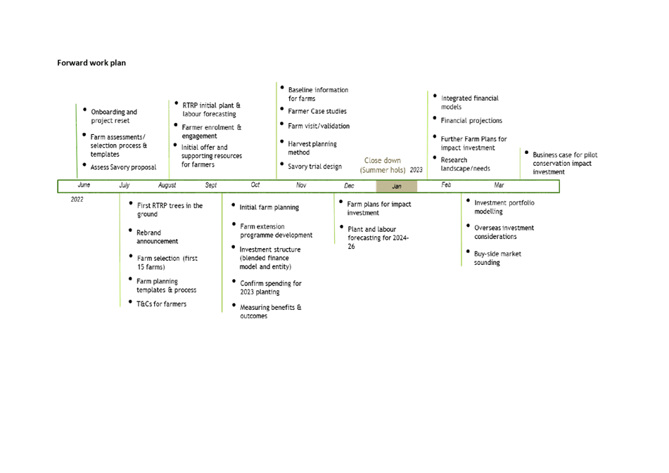
Hawke’s
Bay Regional Council
Environment
and Integrated Catchments Committee
6 July
2022
Subject: March/April
2022 double rain events – Flood scheme impacts, recovery and lessons
learned
Reason for Report
1. This report outlines some
brief details and the response to two closely spaced weather events on 21-31
March and 12-14 April (Ex-Cyclone Fili) 2022. These events required
Regional Asset and Works Group weather event management resources to be
activated for an emergency response. Learnings for future event
management were generated from the event and a comprehensive technical flood
report is being prepared and is expected to be completed by September 2022.
Executive Summary
2. The weather events included
significant rainfall, high coastal swell conditions and river level rise in the
Wairoa and CHB areas on 24-25 March 2022, with clear skies occurring in CHB by
26 March, but persistent rainfall occurring in Wairoa until 29
March. This rainfall was followed quickly by the tail end of Ex-Cyclone
Fili, which was forecast to hit the east coast of New Zealand sometime just
after 12 April 2022, but fortunately followed a path away from the east coast
and only caused minor additional rainfall in Wairoa, and several small-scale
intense rain bursts in CHB.
3. Metservice provided
rainfall forecasts in the days preceding the initial rainfall, and the HBRC
flood forecasting system was used to predict ongoing river levels and possible
inundation areas. The long duration of the event and variable rainfall
forecasts meant the Asset Management team maintained forecasting and
reconnaissance throughout.
4. The forecasts enabled HBRC
resource deployment ahead of the events, with the main focus being Wairoa and
CHB, as well as some parts of the Heretaunga Plains. The events generated
major Civil Defence Emergency Management (CDEM) responses from Wairoa and CHB
District Councils concerning their roading and infrastructure networks but
remained as a moderate event for HBRC flood control assets.
5. Post-event helicopter
surveys were conducted to check CHB and Wairoa scheme areas, and ground
follow-up teams assessed and organised remediation of HBRC and CHB stopbank
damage. The Tarewa cycleway swing bridge over the Tukituki River below
Waipukurau was destroyed and Works Group worked with engineers to safely remove
the remains from the river. The recently completed HBRC IRG project on
the Waipawa River at SH50 performed as intended in the flood event. The
event did not generate sufficient damage to trigger a claim under the terms of
HBRC insurance cover.
Strategic Fit
6. This activity supports the
Water and Land Priorities in the Strategic Plan 2020-2050 in managing and
maintaining safety and climate-resilient security, and sustainable land
use. These event responses are a core part of the Regional Assets and
Works Group functional service delivery across schemes administered by HBRC.
7. The report also seeks to
outline the ongoing learning and development that these event responses allow
to those involved and to the wider community of stakeholders.
Background
8. Regional Assets have
weather event response as a core function and, when events are forecast by
Metservice, a corresponding internal risk impact analysis is performed and
maintained as the temporal forecasts are provided until the event occurs or
diminishes to a non-watch risk level. Based on this process the Schemes
and Engineering staff develop a response plan to deal with the emerging weather
event and engage Works Group to begin appropriate preparation according to the
likely weather impact.
9. This is internal to
Regional Assets and HBRC CDEM but takes inputs from regional/national CDEM
notifications in the initial phase until the probability and extent of direct
weather impact are known closer to the current time. HBRC Incident
response was partially activated with an Incident Controller engaged with CDEM
but the event run internally. For the second (Ex-Cyclone Fili) event the PIM
was also activated. HBRC provided intelligence into CDEM for both events
10. Typical activities are
updating of hydraulic models to forecast indicated river or drainage scheme
impact, and maintenance preparation (pump station screen clearance checks,
positioning of mobile pumps and generators, notification of at-risk activities
in flood impact areas, resource planning).
Tractor pump night operation during the event
11. These events were typical
of those experienced by HBRC catchments, with often locally-intense weather
impacts within specific geographic areas based on the event rainfall
distribution, and seasonal coastal high swell conditions. The events will
be summarised in a formal flood report, but for the purposes of this update the
interim summary report is included in the appendix.
12. Weather event damage to 17
sites on HBRC-managed Great Ride cycleway assets was assessed and a successful
funding request was made for $50,000, developed under the Ministry of Business,
Innovation and Employment’s (MBIE) ‘Maintaining the Quality of Great Rides
Fund’ (Enhancement & Extreme Event funding). An additional claim of
$11,500 for Hastings DC managed cycleway sections was also successful. This
funding is accessible from MBIE under the accredited ‘Great Ride’
status of the cycleways that are part of the NZ Cycle Trail, and by engaging
the repair services through a recognised contractor with ‘Master Track
Builder’ status. The application was approved based on a well-prepared
document meeting all funding criteria, and repairs were completed to damaged Great
Ride trail areas quickly.
21-31
March 2022 Event
13. The initial March event
generated a series of rapid rise hydrographs in the early hours of Thursday 24
March in several catchments including the Wairoa River and its tributaries, the
Upper Tukituki River and its tributaries, as well as several other minor
catchments.
14. The Westshore gravel bank
was significantly eroded by high swell conditions and minor inundation occurred
into the reserve area. The gravel bank has been restored to nominal
configuration.
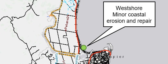
15. Concurrent high sea swell
conditions are an issue for rivers which struggled to maintain discharge
against the sea swell building a shingle bar across the mouths and creating
elevated water levels in the lower reaches of smaller rivers. Under the
direction of HBRC Regional Assets, the Wairoa River mouth was mechanically
opened by the local contractor prior to the event, which resulted in the
prevention of flooding due to lower water levels in the lower reaches of the
Wairoa River in both events. This is a wider ‘fair weather’
issue for most HB rivers.
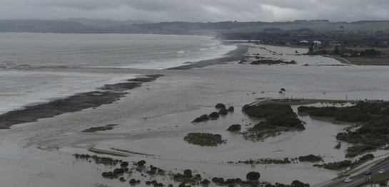
Ngaruroro mouth at Waitangi Regional Park
16. In the CHB area the
Waipawa, Makaroro, Mangaonuku, Tupiko and Upper Tukituki rivers all rose
rapidly early on 24 March which caused local erosion and inundation
issues. Some drainage areas in the Crownthorpe/Redcliffe and
Clive/Haumoana areas also suffered from localised intense rainfall resulting in
short duration, high water levels and local flooding. Several field observation
reports showed a rapid rise in water levels from 0400 Thursday with a peak
around 0900 followed by a relatively rapid drop of the peak to a lower flood
flow at sites in CHB and Crownthorpe/Taihape Road area.


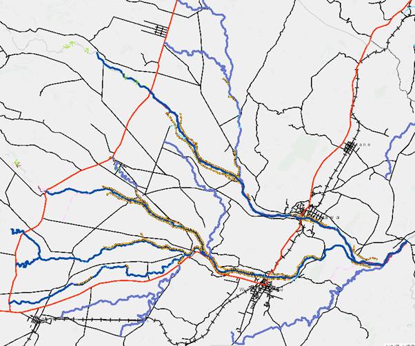
Locations of repairs
Central Hawkes Bay
17. Out of channel flows were
generated in CHB rivers and drainage channels; damage to some stopbanks in the
Mangaonuku true right bank, and the destruction of the Tarewa suspension bridge
on the Upper Tukituki River downstream of Waipukurau. This bridge was
subsequently demolished and the structure recovered safely by HBRC Works Group
resources to the HBRC Waipukurau yard where local community groups are helping
salvage materials for other cycleway initiatives.
18. A blocked culvert on the
Turirau drain off Springfield Rd caused erosion of adjacent cycle trails, and
there were widespread short-term issues often caused by debris washed into
culverts (Clive /Haumoana/Elephant Hill Area).
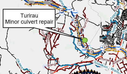
19. Concurrent high swell
conditions also caused river mouth blockage at several sites initially and was
managed under normal operation processes. Once the increased river water volume
travelled downstream to the sea most had sufficient flow to clear the bar at
the river mouth and maintain drainage. The Wairoa River was the most
significant as a new, more direct opening was prepared ahead of the two events
and was successfully established with local contractor support.
20. Heretaunga Plain rivers and
drainage were well-prepared and after the initial night response there were no
major issues or long-term inundation so resources were progressively stood down
as the event passed.
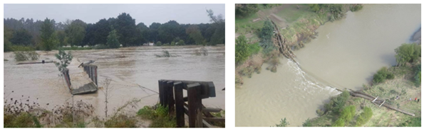
Damaged Upper Tukituki Cycleway Tarewa Swing Bridge
21. The flood event caused
localised inundation and bank erosion at various CHB sites with a CHB water
intake for Waipawa compromised by erosion of a non-HBRC scheme stopbank
(Waipawa BM22L), and subsequently priority repaired by HBRC resources on CHBDC
behalf as a priority restoration.
22. HBRC stopbanks overflowed
on the Mangaonuku true right bank causing inundation of local farmland, and
minor erosion of a CHB road embankment. Stopbanks have been repaired and good
grass cover restored. Survey is being undertaken of river benchmarks to
determine the gravel bed changes from the event in CHB. Boundary fencing
repairs in CHB are scheduled but not yet complete.
12-14
April 2022 (Ex-Cyclone Fili)
23. Works Group (truck,
excavator and two chainsaw operators) and Schemes staff were deployed to Wairoa
ahead of the Cyclone Fili event to deal with the forecast potential of Cyclone
Fili tracking on an easterly path and high winds. Northern Wairoa
drainage schemes (Paeroa, Ohuia and Kopuawhara schemes area saw out of channel
flooding and some inundation. Staff were able to work on identified
issues ahead of weather arrival, and when no further work was possible were
made available to the Wairoa DC CDEM activation as wider regional issues became
more of a CDEM priority.


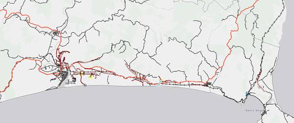
Location of repairs- Wairoa
24. A helicopter inspection was
conducted over the Wairoa River for flood indicators and the schemes in the
northern coastal strip from Wairoa to Mahia/Kopuawhara. With the more westerly
track of Cyclone Fili the impact was still significant for Wairoa District
infrastructure and landowners, but the scheme impact was within expected
forecast parameters.
25. Issues were identified with
blocked stream channels in the North Clyde area around the Wairoa stockyards, a
pump tripping out at the Ohuia main pump station, and over-bank flow on the
Kopuawhara. Ground checks were conducted in the following week.
Concerns with drainage water from the Tuhara drain north of the Ohuia scheme
were raised by Ohuia Station staff with schemes staff. Survey will be
required to check the true right bank stopbank levels at Kopuawhara, and a
walking ground check on the Paeroa drainage channels has been completed.
26. An insurance claim is
unlikely to be pursued for damage from these events as the minimum threshold
value has not been achieved. Though there was a swing bridge destroyed,
Westshore gravel protection erosion, and several stopbanks eroded, the minimum
insured value was not met. The swing bridge replacement will require a
higher level of performance and ‘betterment’ (greater level of
service) is not covered under insurance cover. Remediation of flood
damaged HBRC assets will require funding from Scheme Disaster Damage Reserves.
The Tarewa Swing bridge will need to be revised and funding sought for a higher
flood clearance. Options for this work are currently being prepared and
priced.
Discussion
Event Response
27. The two events were the
first events in some time to get close to a wider CDEM activation for HBRC.
HBRC incident response was partially activated with Incident Controller,
Intelligence support to CDEM in the initial event and Incident Controller,
Intelligence support and PIM in the Post-Cyclone Fili event.
28. The events required full
field responses by Regional Assets and Works Group staff where staff were required
to reprioritise away from business as usual tasks during the 2-3 day events,
and for some priority recovery tasking in the weeks following.
29. New staff were buddied with
more experienced staff but the need to maintain ‘fair weather’
access and operational familiarity for effective and safe event management was
raised in the post-event review. Roles and responsibility awareness needs to be
maintained, and mock event sessions run on a scheduled basis. This
applies to HBRC response and potential CDEM roles as well.
30. The post-event review
meeting has identified some improvement items from the events which should
improve future event responses and provide areas for further process
improvement.
Works
Group
31. The event response provides
good evidence of the critical role and value that Works Group staff and
resources enable HBRC’s event response capability. The staff worked
closely with Regional Assets Schemes and Engineering staff in the pre-planning
phase, during the events and in the response phase.
32. This was well illustrated
in the Cyclone Fili response for Wairoa where our local contractors were
committed to significant wider flood response tasking from Wairoa DC and NZTA
and decisions were able to be made to resource an excavator and transporter
with additional chainsaw operators for the forecast work.
33. Fortunately the wind impact
was not as widespread as forecast and staff were able to be tasked under the
Wairoa DC CDEM management having responded to immediate HBRC scheme issues.
34. Works Group also safely
recovered the Tarewa Swing bridge debris from the Tukituki River and were able
to prioritise the critical stopbank restoration in the CHB area to protect the
CHBDC Waipawa water intake, and the Mangaonuku area.
35. The local knowledge, skills
and resources were deployed quickly and safely based on excellent working
relationships with HBRC Schemes and engineering staff.
Insurance
36. The damage from these
events did not meet the minimum claim threshold for a claim in this instance (M$1.5
claim minimum).
37. Event-related damage and
remediation activity costs are summarised in the table below. Note that
any replacement of the Tarewa swing bridge will require a better flood
clearance, so a replacement structure is likely to be more expensive than the
insured book value and impacted by current industry cost pressures. Options are
being developed at present, and discussions with CHB stakeholders continue
around this for initial concept options.
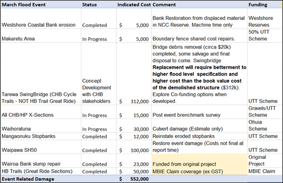
38. The work in tracking the
event costs lead HBRC to discuss claim process with peer organisations who have
dealt with larger flood claims. The recommendation was to prepare ahead to
ensure insurance claim management is well structured for future major events to
ensure insurer information requirements and coverage criteria are well
understood. This will add value to future claim management.
Next Steps
Response management
39. From these events there has
been a raised awareness of staff maintaining ‘fair weather’
familiarity with schemes for situations when ‘bad weather’ presence
is required. With staff turnover the working familiarity needs to be
maintained, staff working relationships developed and effective health and
safety provisions maintained. Staff resources for forward deployment ahead
of events to be formalised operational processes.
40. Operational checks and
provisioning for local documentation and supporting materials for tractor pump
and generator operations at pump stations so spares are available if required.
41. Review radio options for
all field operations. Fleet Link radio options coming in the current Project
Tarsier (radio replacement) will improve situational awareness particularly for
longer events in more remote areas. Continue to look at MS Teams options
for operational and reporting improvements.
42. Routine quality assurance
on processes, equipment provisioning, maintaining lists of contacts,
contractors, training and post event reviews adds value to weather event
response effectiveness.
43. Continue to maintain routine
CDEM role familiarisation.
44. Post event review has been
run and improvement areas identified in the items above.
Insurance
45. Prepare ahead to ensure
insurance claim management is well structured for future major events to ensure
insurer information requirements and coverage criteria are well understood.
Decision Making Process
46. Staff have assessed the
requirements of the Local Government Act 2002 in relation to this item and have
concluded that, as this report is for information only, the decision-making
provisions do not apply.
Recommendation
That
the Environment and Integrated Catchments Committee receives and notes the March/April 2022 double rain events – Flood scheme
impacts, recovery and lessons learned staff report.
Authored by:
|
Ken Mitchell
Asset Management Engineer
|
Craig Goodier
Principal Engineer
|
|
Harry Donnelly
Project Engineer
|
Martina Groves
Manager Regional Assets
|
Approved by:
|
Chris Dolley
Group Manager Asset Management
|
|
Attachment/s
|
1⇩
|
Interim Flood Event Summary Report:
21-31 March and 12-14 April 2022
|
|
|
|
Interim Flood Event Summary Report: 21-31
March and 12-14 April 2022
|
Attachment
1
|
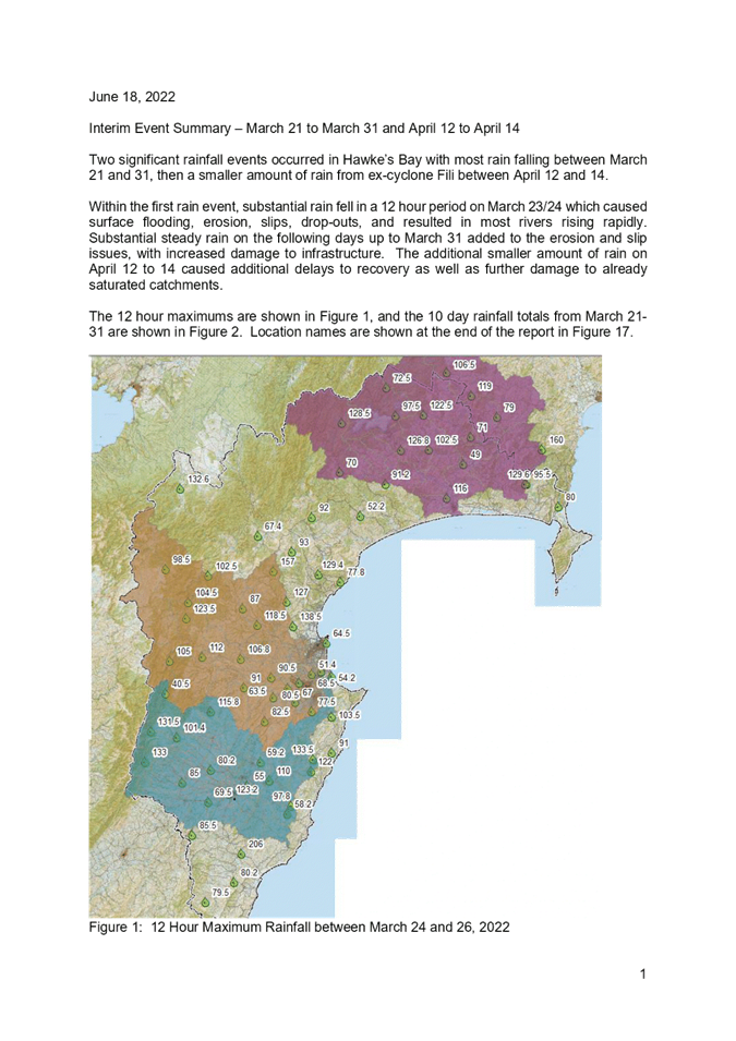
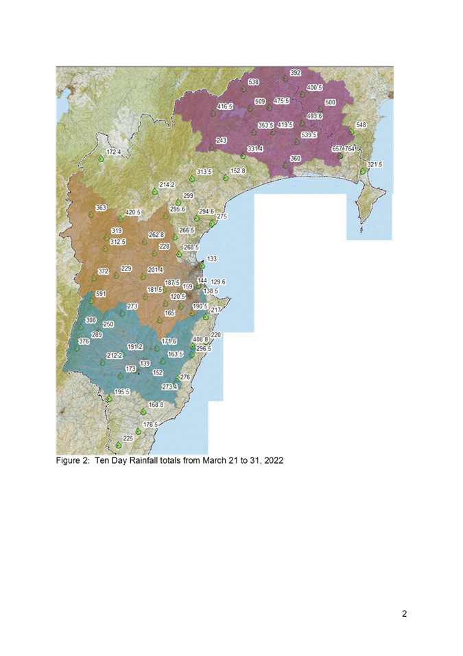
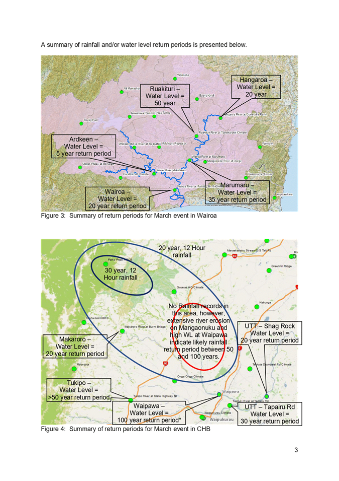
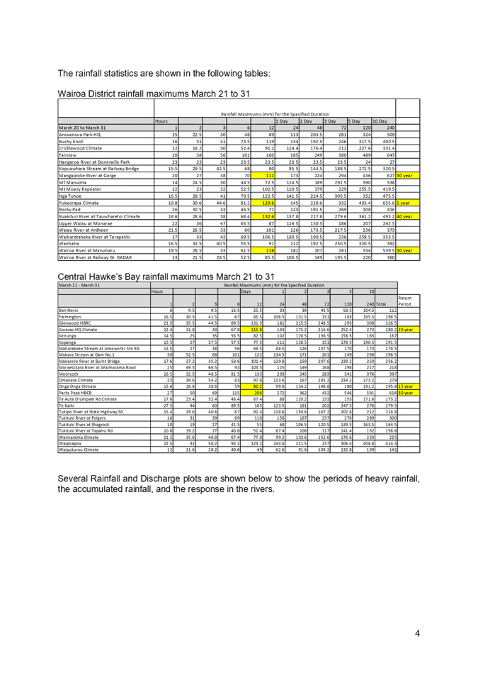
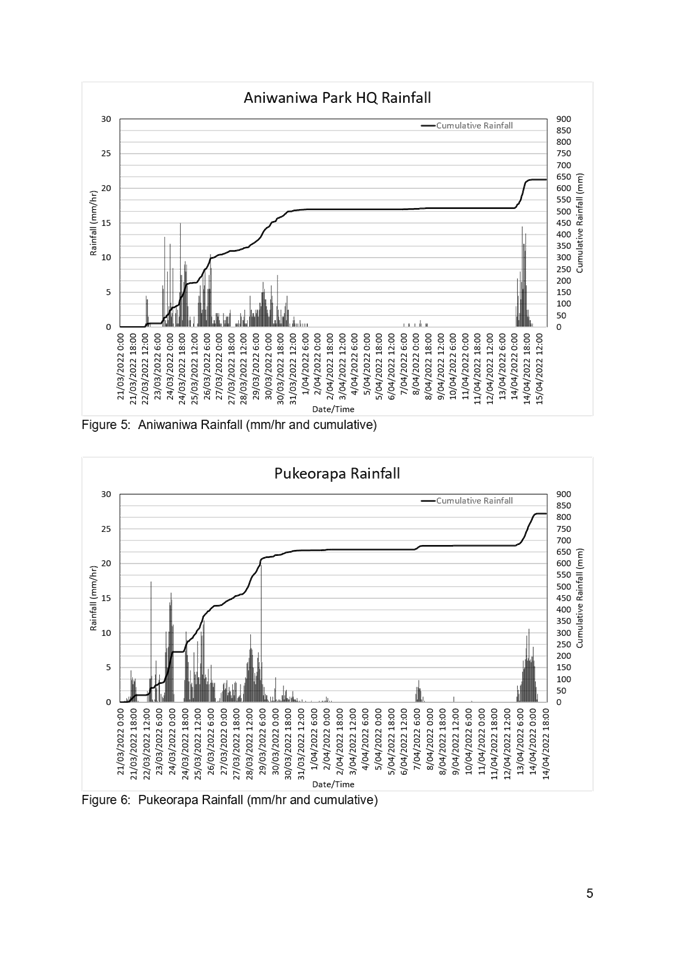
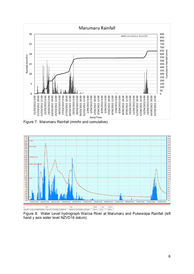
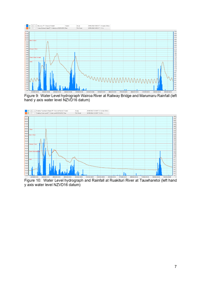
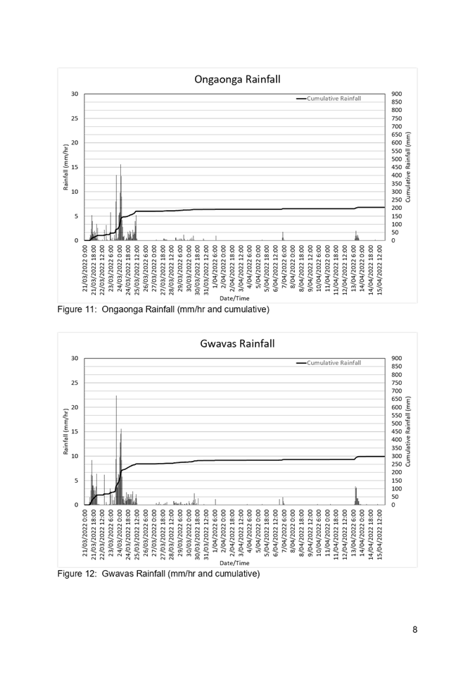
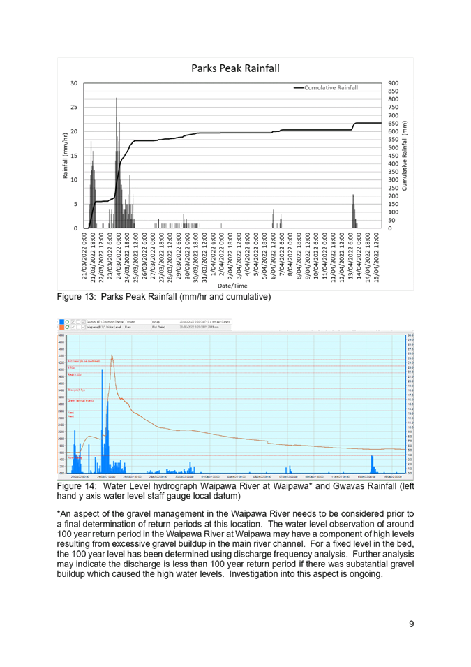
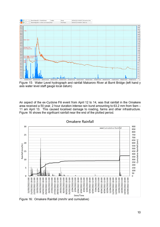
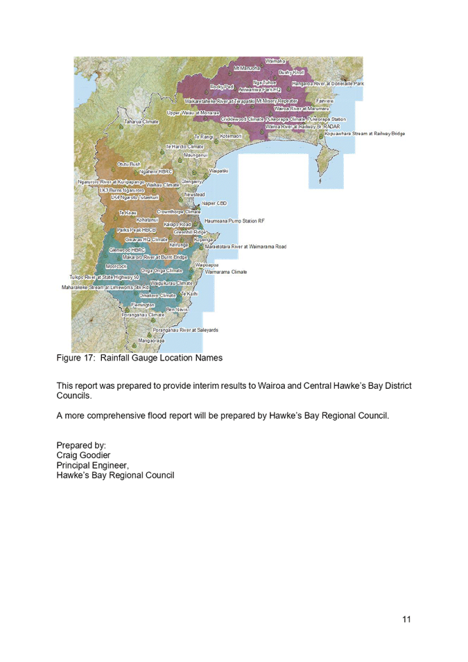
Hawke’s Bay Regional
Council
Environment
and Integrated Catchments Committee
6 July
2022
Subject:
Gravel Extraction - current situation and new global consent
Reason for Report
1. This item updates the
Committee on riverbed gravel extraction undertaken as part of Hawke’s Bay
Regional Council flood control functions, including discussing some challenges
the region is facing with decreasing gravel availability in the rivers, and a
brief update on the status of the new global resource consent process.
Background
2. Under the Soil Conservation
and Rivers Control Act 1941, regional councils have a statutory responsibility
for flood control. To achieve this in the context of sediment build-up, the
Asset Management Group (AMG) encourages aggregate suppliers to excavate gravel
from the dry parts of the river beds (sometimes referred to as beaches), with
the objective of maintaining the bed at a design grade. The design grade is the
calculated grade of the river bed (i.e. the bed level at any particular
location) required to maintain the required floodway height and area.
3. This gravel extraction
activity is authorized by very short-term consents, typically one year, using a
Council-managed consent application template system. However, this system is
not delivering the desired results for extractors (who seek longer-term
certainty) or for HBRC in terms of achieving its flood management objectives.
4. In the last five years, the
volume of gravel available for extraction has decreased in the lower reaches of
the Ngaruroro, Tutaekuri and Lower Tukituki Rivers. This is due to not having
high flows with sufficient velocity to move the gravel downstream. The last
significant gravel movement we recorded was during Cyclone Bola.
5. The Ngaruroro River is the
main river from where gravel has been extracted in the past. It has been
over-extracted historically, at an average rate of 300,000m3/y,
nearly three times the net supply rate of 120,000m3/y. The grade
line, a mean bed level that determines the availability of gravel in the river,
has been lowered in the past to 'create' more availability. The current grade
line and the latest bed survey show availability of 386,000m3
between Ormond Rd, Twyford, and 740,000m3 between Marakekakaho and
Matapiro Road. This means that, at current extraction rates and without a
significant flood event to replenish gravel volumes, there will be no more
gravel available in the Ngaruroro River within 1 to 2 years.
6. The gravel extraction
industry is seeking higher volumes from the reaches where gravel is unavailable
(based on gradeline assessments), and are challenging our decisions to move
extraction activities where the gravel is available, for example, the Upper
Tukituki scheme in Central Hawkes Bay.
7. Transport costs are a key
factor for extractors to manage, and these have increased significantly in
recent years. However, there is the opportunity to submit a tender for the IRG
gravel extraction and gain subsidies from this funding.
8. The Tutaekuri River and
Lower Tukituki are facing similar issues with restrictions to the extraction
and allocation in all areas.
9. The Allocation in the Esk
River has been restricted in the last three years with the minimal allocation of
only 5000m3 p/a.
Global Consent
10. As part of implementing the
Hawke's Bay Rivered Gravel Management Plan 2017[1]
(GMP), the Regional Assets Section of HBRC has applied for global resource
consent to extract gravel from the Ngaruroro River, Tukituki Catchment Rivers
and Tutaekuri River (the Applications).
11. The GMP was developed with
the purpose "to sustainably manage gravel extraction from rivers for
flood protection purposes, and to ensure community safety while allowing for
economic development without compromising cultural, social and environmental
outcomes and values associated with the region's freshwater resources."
12. The GMP established the
concept of Authorisation Zones within which the Regional Assets Section of HBRC
would hold resource consents for gravel extraction and would issue
authorisations to commercial gravel extractors to operate within those zones.
13. The authorisation process
is intended to provide improved management of gravel extraction for flood
control purposes by establishing a single, accountable consent holder and
comprehensive management regime, replacing the existing practice of issuing
short duration (annual) resource consents directly to extractors (which is the
practice that remains in place today).
14. The applications were
lodged in October 2017, and following an extensive further information process
were publicly notified in February 2019. 7 submissions were received, with none
opposing. The submitters were First Gas Limited, Hawke’s Bay Fishing and
Game Council, Michael Barker, New Zealand Transport Agency, Ngāti
Kahungunu iwi Inc, Te Taiwhenua O Heretaunga and Winestone Aggregates.
15. The Regional Assets Section
of HBRC sought to resolve matters directly with submitters in an attempt to
reach an agreed outcome, rather than take the matter to a hearing. This process
was unsuccessful, with the matter heard before a Hearing Panel on 10 December
2021.
16. After hearing evidence from
Regional Assets Section of HBRC, Ngāti Kahungunu iwi Inc and Te Taiwhenua
O Heretaunga, the Hearing Panel adjourned the hearing, and directed that
caucusing occur to refine the proposed conditions of consent. That process has
now been completed and the outcome is with the Hearing Panel to issue a final
decision on the Applications.
17. If the consent applications
are granted by the panel, and no party appeals the decision, Regional Assets
Section of HBRC intends to implement the new consent regime in the next gravel
allocation process from July 2023.
Gravel Supply and Allocation processes
18. Historically, Hawke's Bay's
rivers have transported large volumes of gravel and other sediments from
Ruahine, Kaimanawa, and Kaweka Ranges, depositing in onto alluvial plains to
the east of ranges. This sediment transport process resulted in the rivers meandering
across the alluvial plains over time as braided and semi-braided river
channels.
19. Riverbed gravel extraction
is carried out as a critical maintenance activity to maintain flood water
conveying capacity and address erosion issues in the Upper Tukituki Flood
Control Scheme (UTTFCS) and the Heretaunga Plains Flood Control Scheme (HPFCS).
Gravel extraction has previously occurred in low volumes in the Esk River but
has not occurred in recent years. It is also undertaken in the Mohaka River,
but not for flood control purposes.
20. This activity is managed by
HBRC under its regulatory (RMA) and flood control management functions, but
with commercial operators undertaking the extraction. This provides benefits to
the whole region, by cost-effectively maintaining flood control schemes and
providing benefits to the regional
economy and construction industry.
21. The current allocation
process is by receiving contractors' requests annually in April. The AMG
received approximately 90 requests from different contractors this year. The
AMG then allocates gravel based on gradeline assessments of gravel availabilty
and advises contractors on volumes and areas by a letter in May. Before
receiving allocation requests, the AMG meets with the industry (gravel extractors)
and explains the process, challenges with availability, areas of concern, and
ecological and environmental monitoring matters. This meeting also provides an
opportunity for contractors to raise and ask any questions.
22. Due to the growth in infrastructure
in the region, gravel extractors are struggling to find suitable materials for
roads and development. Contractors are asking for significantly more gravel
than in previous years. Refer to the graph and chart below, which shows the
availability and allocation for the Ngaruroro River.
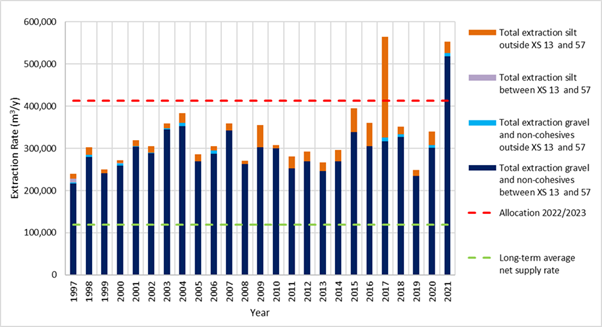
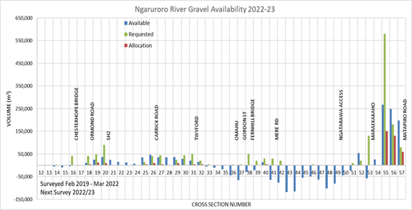
23. The Engineers and Gravel
Assurance Officer within the AMG annually review the availability from riverbed
survey data and site visits; this is then allocated fairly to contactors. It is
important to note that we can't distribute/allocate gravel below the established
design grade line each year.
24. A modelling study about the
long-term effects of gravel extraction and beach raking in the Tukituki
and Ngaruroro has been carried out by NIWA. The Tukituki is in the
process of being finalised. The Ngaruroro was completed 10 years ago. The main
recommendations for gravel management from this study are:
24.1. Ngaruroro - very little
aggradation occurs naturally upstream of Ohiti, which means that once the
available gravel has been extracted, minimal extraction will be sustainable in
this reach.
24.2. Ngaruroro - gravel
extraction does not affect the overall natural supply rate. Still, it changes
the distribution of gravel deposition area around Fernhill, where historical
extraction rates have been the highest.
24.3. Ngaruroro - beach raking
significantly influences gravel transport at and downstream of the raked areas.
For this reason, gravel raking should be encouraged upstream of Maraekakaho to
facilitate deposition in the lower reaches currently in deficit.
24.4. Cease extraction from the
Lower Tukituki and the lower reaches of the Middle Tukituki in the short and
long-term is due to long-term negative effects on coastal supply.
24.5. Encourage the establishment
of long-term gravel extraction plants in the depositional reaches of the Upper
Tukituki, aiming at maintaining long-term extraction rates at approximately the
sustainable extraction rates (100,000 m3/year in total).
24.6. Cease extraction from the
degrading upstream reaches of the Upper Tukituki.
24.7. Consider reducing the
frequency or stopping beach raking in the Lower Tukituki and upper sections of
the Upper Tukituki.
24.8. Continue with the river
raking programme in the rest of the Upper Tukituki.
25. The AMG plan to model the
remaining main rivers (Tutaekuri, Esk, Waipawa), where extraction occurs by
2024.
Next steps
26. The AMG are looking at
improving the process of allocation and management of riverbed gravel in the
future; the new global consent, if granted, will reinforce the need for change.
27. In order to avoid a
complete depletion of the gravel resources in the river, the criteria used to
allocate gravel was:
27.1. No allocation in areas with
negative availability (except 5,000m3 at XS 40)
27.2. Requests between
Maraekakaho and Matapiro Rd capped at a maximum of 50,000m3 per
individual contractor based on their requested volume and company size. The
total amount allocated here is 340,000m3, which is 46% of the
current availability in the area.
27.3. No more consents to be
issued during the year on the Ngaruroro.
Decision Making Process
28. Staff have assessed the
requirements of the Local Government Act 2002 in relation to this item and have
concluded that, as this report is for information only, the decision making
provisions do not apply.
Recommendation
That the Environment and Integrated
Catchments Committee receives and notes the Gravel Extraction - current
situation and new global consent staff report.
Authored by:
|
José Beya
Principal Engineer
|
Martina Groves
Manager Regional Assets
|
Approved by:
|
Chris Dolley
Group Manager Asset Management
|
|
Attachment/s
There are no attachments for this
report.
Hawke’s
Bay Regional Council
Environment
and Integrated Catchments Committee
6 July
2022
Subject:
Karamū Urban Catchment Advisor
Reason for Report
1. This item introduces the
Karamū Urban Catchment Advisor, Andy
McCall, along with an overview of his initial observations and high-level work
programme.
Executive Summary
2. During development of the
LTP an Urban Catchment Advisor for the Karamū Catchment has been created
and now filled. Andy McCall has started in this role and has been getting up to
speed with the key issues and meeting stakeholders. Some of the key issues identified
in the catchment include excessive nitrogen, phosphorus and sediment, high
water temperature, low dissolved oxygen, industrial run-off, and excessive
aquatic weed growth. Shading is likely to be the most effective single tool for
improving water quality in the immediate future with a longer-term focus on
nutrient management in the upper and lower catchment, and stormwater management
in the Hastings area. The position will work collaboratively with staff in the
Integrated Catchment Management Group (ICMG) while not overlapping the work of
the ICMG. A high-level awareness of activities undertaken by ICMG will be
maintained by the Karamū Advisor and vice versa, with ICG catchment
advisors focusing on the rural aspects of the catchment, and the Karamū Urban
Advisor focusing on the urban aspects.
Background
3. The Karamū Catchment
comprises 238 lineal kilometres of waterways and drains 514 square kilometres,
with the upper and lower parts of the catchment (Heretaunga plains) heavily
tile drained. In 1969 the Ngaruroro was diverted to its current channel,
leaving the Karamū Stream to flow into the old channel. The Karamū
Stream now feeds into the lower Karamū Stream (Clive River) and Ngaruroro
Tawhito (Old Ngaruroro). The major types of land use in the catchment are 53%
sheep & beef, 16% perennial cropping (including orcharding), and 12%
short-rotation cropland. Settlements, exotic forest, and urban parkland/open
spaces comprise 8% of land use (Hawke’s Bay Regional Council, 2020).
 Figure 1.
Hawke’s Bay Land Use 2020
Figure 1.
Hawke’s Bay Land Use 2020
4. The streams in the
Karamū Catchment are highly modified, with extensive channelling and
straightening having occurred to aid in drainage and flood protection (National
Institute of Water and Atmospheric Research, 2017). These streams are characterised
by low gradients which lead to sediment deposition along the stream bottoms (up
to 40mm), as well as presenting a challenge to flood mitigation.
5. The Karamū Catchment
contains some of the most polluted waterways in the Hawke’s Bay. The
streams suffer from a mixture of sedimentation, nutrient run-off from
horticultural and agricultural activities in the upper catchment, run-off from
industrial sites including packing sheds, tanneries, food processors, and
stormwater run-off from Hastings township.
Water Quality issues in the Karamū Catchment
Sedimentation
6. The waterways in the
Karamū Catchment have low gradients which allow sediment to fall from the
water column and collect. In some places sediment is up to 40mm thick. The
sediment is nutrient rich, as is the water column. Many aquatic plants have the
ability to preferentially select between the water column and the sediment for
nutrient uptake (via foliage or roots). Additionally, flows in the Karamū
are insufficient to flush out sediments.
Nutrients
7. Total nitrogen (TN) is
consistently high across the Karamū Catchment and often exceeds the ANZECC
guideline trigger value, while dissolved inorganic nitrogen (DIN) is more
variable.
8. Total Phosphorus (TP) is
consistently above the ANZECC lowland trigger value across all sites in the
Karamū Catchment aside from the Raupare Stream. Much like TP, Dissolved
Reactive Phosphorus (DRP) is consistently above the ANZECC lowland trigger
value across all sites.
Bacteria
9. E. coli concentrations have
resulted in all SOE sites in the Karamū Catchment being graded as not
suitable for primary contact recreation. This is consistent during times of
high rainfall as well as average flow.
Ecosystem health
10. Dissolved oxygen (DO) is at
risk of being critically low in the Awanui and Poukawa Streams. Sampling has
shown Poukawa Stream to be consistently below ANZECC guideline levels.
11. The biomass of macrophytes
is high in the Awanui, Raupare and Karewarewa Streams and exceeds guidelines
for protecting the ecology of the streams, as well as flow conveyance and
recreation.
12. The Macroinvertebrate
Community Index (MCI) score for all sites sampled in the Karamū Catchment
were poor which indicates severely compromised ecosystem health. This is likely
due to a lack of habitat, high water temperature and low oxygen (Matheson,
2017).
Discussion
13. The Karamū Catchment
encompasses a wide variety of land use types of a large geographic area. It has
heavily modified waterways that have largely been historically regarded as
flood assets with a primary purpose of moving water during heavy rain/flood
events. These waterways are characterised by low gradients, shallow depths,
high nutrient inputs, lack of habitat, and extreme oxygen minima. To improve
water quality will take a long term and wide-ranging approach.
14. There are with 2149 consents
within the Karamū Catchment, with 1057 discharging to water directly. The
average age of the latter consents is 6.7 years. The overwhelming majority of
horticultural activities in the catchment will be operating under existing
resource consents. Where non-compliances are identified, they can be pursued by
regulatory means. However, a regulatory approach to limiting nutrient loss to
waterways is not something that can be pursued until those consents come up for
renewal (at which point consent conditions could be strengthened). Generally,
discharge consents are issued for a period of 20 years. Under TANK, existing
consents will be subject to review, which may lead to tighter conditions being
applied to current discharges.
 Figure 2.
Consent discharging to water in the Karamū Catchment
Figure 2.
Consent discharging to water in the Karamū Catchment
15. The best approach may be to
work with industry groups to promote best practice fertiliser and irrigation
application on vineyards, orchards, and sheep/beef farms. Small changes to the
timing of irrigation and fertiliser use may have a significant effect on the
loss of nutrients to waterways from these operations. Given that much of the
Heretaunga Plain is drained artificially via tile drains, the potential to
intercept and treat high nutrient loads emanating from these drains holds great
potential. Research into these drains and potential mitigation measures is in
its early stages, although initial results are expected over the next year from
the AgFirst trail being conducted at present. In support of best practice adoption
in the catchment, a Karamū working group may be set up comprised of
representatives from HBRC, HDC, industry and iwi. This may well be a
requirement (based on requirements of NCC/HBRC Tidal Gate Discharge Consent) of
HDC as part of their new global consent, in which case it would be idea for the
Karamū Urban adviser to be a part of it.
16. The impact of stormwater
discharge into the Karamū Catchment is likely to be mitigated under the
new HDC global stormwater consent which has been lodged with HBRC. This will
include more catch pit filters, first flush deflection systems and end of pipe
treatment systems. These are aimed at preventing contaminants entering the
receiving environment. This is in addition to the regulation of consents owned
by HDC within the stormwater network.
17. Due to the low gradient of
the waterways in the lower Karamū Catchment it is not possible to use
flushing flows to remove sediment. Therefore, the waterways will not return to
gravel/pebble bottomed streams. Supplementary flows, however, could assist with
improving the oxygen levels in these waterways, particularly during periods of
low flow (typically the warmer months of the year). This could potentially be
achieved via groundwater abstraction.
18. The Resource Management
(Stock Exclusion) Regulations 2020 will have a positive impact on the
Karamū by reducing erosion from cattle on riverbanks and reducing direct
inputs of bacteria and phosphorus from animal effluent entering the waterways.
These regulations take effect for existing pastoral systems from June 2023
– and will effectively require cattle to be fenced out of waterways. HBRC
has already committed to stock exclusion in the Karamū catchment on its
own land holdings, however the exclusion of stock from private land is likely
to have a large effect as well.
19. Riparian planting appears
to be the most effective single tool available to mitigate a variety of water
quality issues. Riparian planting will stabilise the stream banks, thereby
reducing erosion and sedimentation. Planting will provide shading, which lowers
the water temperature. This suppresses the growth of macrophytes and algae as
well as improving the dissolved oxygen saturation. Ultimately, planting has the
potential to improve the biodiversity (MCI) of the waterways while also
reducing the need for spraying or weed boating to control aquatic weeds.
20. There is growing community
pressure to improve the quality of many of these waterways, which are often on
the doorsteps of communities and therefore highly accessible by the public.
Riparian plantings must not restrict the primary flood mitigation role many of
these waterways play in safeguarding our communities. In many locations,
a digger may need to reach over the top of riparian plantings to extract logs
and other debris that may impede water flow. For example, the use of small low
plantings (such as carex/sedges) on the bank edge can be used to help stabilise
the banks, filter over-surface flows, provide some shading, while still allowing
a digger to reach over the top of them. A path can then be left for machine
access behind which larger canopy trees can be planted to provide strong
shading to the waterway.
21. The desire to improve water
quality and biodiversity via riparian planting must be balanced with the need
to maintain flood assets as primary flow paths for water conveyance. In
particular, the level of service required of the scheme must be considered when
planning plantings. Riparian planting can be planned in such a way as to
provide good bank stability, effective shading and still allow machine access
to the waterway. A goal of 70% shading has been suggested to significantly
improve water quality. At present a review of the Karamū scheme is
underway which should be able to model the extent of tile drains as well as the
impact of plantings on scheme performance – providing an invaluable tool
for selecting planting sites.
22. There are HBRC drainage
schemes planting plans currently scheduled which will provide options on how
long extensive planting is likely to take, and how much it might cost.
Ultimately, this information can be fed into the LTP to ensure funding is
available for plantings. Community groups and organisations can be advised and
coordinated to tie in with the HBRC programme to provide the most effective
planting.
23. Finally, although riparian
planting can go a long way towards mitigating the effects of pollution in
streams and rivers, it cannot do the same in the receiving environment of the
catchment – The Waitangi Estuary. Thus, in the longer-term nutrient loss
from agricultural/horticultural land use still must be reduced.
Next Steps
24. Establishment of a
Karamū working group, if not established by HDC as part of new global
stormwater consent.
25. Undertake a catchment
stocktake looking to document who is doing what in the catchment to identify
areas of overlap or omission.
26. Identification and
selection of sites for riparian planting/funding via planned Asset Management
Group scheme planting review and feeding of this information into LTP for
funding.
27. Coordination with
compliance team around known areas of non-compliance.
28. Coordination with HDC
around stormwater capture and filtration, as proposed in consent application.
29. Development of a
Karamū Catchment discharge investigation - similar to an investigation
carried by NCC, this could be in partnership with HDC and would look at all the
dry weather discharges to the system. The cost of such an investigation also
needs to be ascertained.
30. Development of a Catchment
Management Plan – based on how the overall catchment is managed,
different actors, HBRC priorities for direct management or enforcement, and
opportunities to influence stakeholders. This Catchment Management Plan will
guide future activities of the Karamū Urban Catchment Advisor.
References
31. Hawke’s Bay Regional
Council. (2020). Ngaruroro, Tūtaekurī, Karamū River and
Ahuriri Estuary Catchments - State and Trends of River Water Quality and
Ecology. Napier: Hawke’s Bay Regional Council.
32. Matheson, F. et al. (2017).
Ecosystem health in highly modified lowland catchments: Karamū catchment,
Hawke’s Bay. Prepared for Ministry for Business, Innovation and
Employment Envirolink Fund.
33. National Institute of Water
and Atmospheric Research. (2017). Ecosystem health in highly modified
lowland catchments: Karamū catchment, Hawke’s Bay. Prepared for
Ministry for Business, Innovation and Employment. Napier: National
Institute of Water and Atmospheric Research.
Decision Making Process
34. Staff have assessed the
requirements of the Local Government Act 2002 in relation to this item and have
concluded that, as this report is for information only, the decision-making
provisions do not apply.
Recommendation
That
the Environment and Integrated Catchments Committee receives and notes the Karamū
Urban Catchment Advisor staff report.
Authored by:
|
Andy McCall
Urban Catchment Advisor - Karamu
|
Martina Groves
Manager Regional Assets
|
Approved by:
|
Chris Dolley
Group Manager Asset Management
|
|
Attachment/s
There are no attachments for this report.
Hawke’s
Bay Regional Council
Environment
and Integrated Catchments Committee
6 July
2022
Subject: Catchment Engagement
framework for policy implementation
Reason for Report
1. This item provides an
update on the work of Council’s Catchments Policy Implementation team in
leading and facilitating the establishment of, and support for, the operation
of community catchment groups, with an example of how this is being implemented
in the Tukituki Catchment. This framework has the potential to be used in other
catchments in future as a way of coordinating HBRC activity, engaging with
catchment groups and working with Iwi/Māori to involve the community in
developing action plans following the Kotahi process.
Executive Summary
2. The Catchments Policy
Implementation team (CI) has continued to develop work with catchment groups in
the region over the last year. This work has a particular focus on the Tukituki
and TANK catchments.
3. As catchment groups have
developed, we have also worked to connect groups to each other.
4. A conceptual structure has
been developed to link Council’s work in catchments with developing
catchment group structures, tāngata whenua and wider community engagement.
Ultimately this structure will help us deliver the catchment action planning
requirements that will follow Kotahi plan development and Tukituki plan
requirements for a monitoring, evaluation, reporting and improvement process.
Strategic Fit
5. The HBRC Strategic Plan
2020-25 has the mission statement Enhancing our Environment together. Together
requires a joined-up approach across teams within council, and an approach
which draws catchment communities together to strengthen connections to their
awa (river) and collectively work on issues that will improve the health of
their catchments. This builds on the good work done by individual approaches
and actions by individual landowners.
6. The work of the team is
primarily in the Strategic Plan focus areas of land (climate smart and
sustainable land use) and water (quality, safety, and climate-resilient
security) and contributes to the following strategic goals and objectives from
the Strategic plan:
6.1. By 2050, there is an
increasing trend in the life-supporting capacity of all of the region’s
degraded rivers and major streams
6.2. By 2025, Land Use
Suitability information is available to all landowners to inform smarter land
use
6.3. By 2025, all farms,
orchards and vineyards operate under a Farm Environment Management Plan or an
independently audited industry best-practice framework
6.4. By 2030, all land-users in
critical source areas have phosphorus management plans being implemented, with
at least 50% of highly erodible land treated with soil conservation plantings
6.5. By 2025, catchment
management plans are established to target improvements on land that lead to
water quality improvements
6.6. By 2050, there are 50% less
contaminants from urban and rural environments into receiving waterbodies.
Strategic
Objectives
7. That Hawke’s Bay
farmers and growers understand their environmental impacts and what they can do
to reduce these, and are implementing good management practice on-farm.
8. That land use is managed to
ensure pathogens and contaminants are being reduced, and water is being
allocated sustainably to highest value use.
9. That farmers and growers
are developing and maintaining sustainable business models that reflect
improving health of land, air, water, their businesses, and their communities.
Other
legislated drivers for the work
Tukituki Plan Change 6
10. In 2015, the Change 6 to
the Regional Resource Management Plan (RRMP) for the Tukituki catchment became
operative.
11. In addition to a property
specific regulatory approach to set bottom line rules and expectations Policy
TT5 1.f also requires HBRC to provide land advisory services and incentives and
prioritise non-regulatory efforts on sub-catchments with high phosphorus (P)
levels, to work with the community and collaborate with the primary sector.
Part of this requires us to encourage industry good practice and identification
of critical source areas to reduce P loss.
12. Work in priority
sub-catchments (places), with catchment communities (people) to identify
critical source areas and encourage industry good practice and practices that
go beyond regulatory bottom lines will deliver on this policy.
13. Rules and incentives alone
will not be enough to reach the instream DRP targets in exceeding
sub-catchments. Collective catchment engagement and action on the issues is
needed.
National
Policy Statement for Freshwater Management (NPSFM 2020)
14. This policy statement
requires councils to consult with communities and tāngata whenua before
preparing a catchment action plan. This may be prepared at the same time as a
regional plan and appended to it or may be prepared later. They must be
reviewed within 5 years.
Background
15. Last year we presented to
this committee background to the development of our work in this area, an
overview of the state of catchment groups at the time, and the work of the CI
team to support further development of catchment groups[2].
16. Since then, work with these
groups has undergone further evolution as linkages between groups have been
formed and have created potential to form larger collectives that can share
administrative and organisational burdens and may attract external funding.
17. A key principle of our work
with catchment groups is that they must be farmer driven rather than council
driven. Our role is to provide support for development to self-sufficiency so
that they can endure. We support groups to run themselves. Groups are
different from each other; they have unique identities, and members decide on
the size, membership, and make-up of their own groups.
18. We work with other agencies
to coordinate support for these groups. Central government is interested in the
growth of catchment groups, and we have worked to raise awareness with them
that regional councils are active in this work and are a key agency for
supporting their success.
19. In November 2021, staff
presented a concept to central government to encourage a targeted investment
and collaborative approach to accelerate development and establishment of
community catchment groups. A paper, Catchment Partnerships delivering
better environmental outcomes, highlights the unique role Regional Councils
have as enablers in supporting community catchment groups. The salient
points from the paper are as follows:
19.1. It noted that councils are
best experienced, resourced, and skilled to lead and facilitate the
establishment of and support the operation of community catchment groups.
Councils understand the issues at place and can provide the right context
(catchment context) that links the best actions to achieve the desired outcomes
19.2. Councils are skilled and
experienced in engaging with and supporting community groups. Councils
also have the skill and experience to turn plans into action, particularly
catchment action plans that include strategies to protect and improve our most
precious environmental resources
19.3. The role of community led
catchment groups in accelerating change through coordinating and aligning
community support, leading to practice change, is well documented. This is a
key enabler to achieving the Government ambition for a low emission economy,
where land use and farming practices must change to deliver the environmental
impact needed
19.4. Council is working with
iwi/Māori in identifying their freshwater values, identifying measures of
freshwater health, and understanding desired environmental outcomes –
supporting mahinga kai. Working with iwi/Māori to understand areas of
historical significance and helping farmers/landowners learn why improvements
to the health of waterways/streams is important to iwi/Māori
19.5. Councillors and staff live,
work, and play at place in catchments. They are actively engaging with
communities, with teams specialising in environmental monitoring/reporting,
environmental science, science translation, policy implementation, consenting
and catchment engagement
19.6. The paper proposed that
with adequate financial support, councils can provide strategic leadership and
support to catchment communities to accelerate and grow the number and
effectiveness of catchment groups – Halt the decline and deliver a
measurable improvement in a lifetime
19.7. It also noted councils’
depth of historical data and information on the biophysical (water
quality/quantity) issues within catchments, with experience in understanding
the causal factors impacting on catchments within the region (the catchment
context)
19.8. Other providers in farmer/landowner
engagement have skills and experience in relationship management although
most (outside of council) lack the sufficient environmental science, policy and
iwi engagement resource that is required to deliver on an effective catchment
engagement strategy
19.9. Councils, as regional
government, deliver on the ambitions of Government through regional plans,
monitoring, compliance and supporting improvement in land use
practices. In doing this work, councils understand that unique
regional attributes may be best served by collaborative delivery between
Council and industry providers to enhance the potential outcome for catchments.
The
Community Action Cycle
20. A recent catchment group
survey (HBRC survey of 26 catchment groups in Hawke’s Bay) identified the
three highest priorities for catchment groups (i.e., already formed, beyond the
establishment phase) were – engaging with Iwi, understanding
water quality monitoring (understanding how and where to invest money in
testing to avoid being over-sold on commercial options), and access
to funding to support the establishment and operation of catchment groups.
21. Catchment partnerships
delivering better environmental outcomes is a model of aligning regional
council skill and capability with communities, and potentially collaborating
with industry to develop robust catchment action plans to deliver better
environmental outcomes.
22. The Community Action Cycle
(CAC – see figure 1. below) accelerates establishment, growth and
maintenance of community led catchment groups. The model supports a regulatory
umbrella of the Resource Management Act to National Environmental
Standards for Fresh Water, Regional Resource Management Plan and Regional
Plans, connected to pragmatic good/best management practices with land,
animals, and people.
23. The model is based on
groups working together to solve difficult problems better than even the best
individual farmer/landowner working alone. Catchment issues can be solved when
there is enough collective action in a catchment. An even better solution is
when people collectively focus actions on solving the issues.
24. The model suggests changing
the emphasis from action designed by policy to an emphasis on promotion and
adoption of good management practices and increased measurement and monitoring,
that then drives a regulatory framework and policy development (practices
inform policy). The three elements (Policy, GMP and measuring/monitoring) have
an interdependent relationship to lead to improvements in environmental
conditions.
25. There are examples of
catchment groups working together to solve complex environmental challenges
(Pomahaka[3],
Waikato River Care, Rangitikei Rivers Catchment Collective) that helped inform
more robust and relevant policy. An operating CAC model will grow and expand
these examples across New Zealand and, the most “at risk” areas.
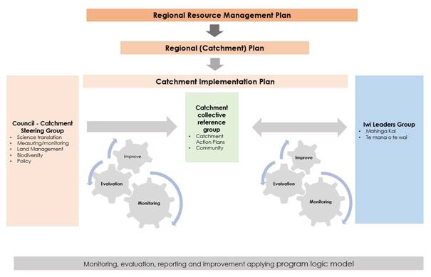
Figure 1: A Catchment Action Cycle Framework
to Coordinate Work in Catchments with Catchment Community Engagement
26. This is a model in
development in the Tukituki catchment.
27. In this model a HBRC
Catchment Steering Group will represent Catchment Delivery, Policy &
Regulation, Biodiversity, Asset Management, Policy Implementation, and other
areas delivering services into a catchment. A fundamental principle of a
steering group is to align service delivery, consistent policy
development/delivery informed by catchment priorities, planned actions, and
measured impacts/outcomes.
28. The Catchment Collective
reference group is made up of a representative from various groups operating at
the sub-catchment level. The model evolving in Tukituki is an agreement to form
an overarching representative group (Tukituki Land Care – TLC),
representing nine sub-catchment groups. The role of the collective group is to
identify and help secure funding for a collective approach, develop and
represent a long-term vision and provide an entity for shared governance,
resourcing, and funding for individual catchment groups.
29. The Iwi leaders’
group is a concept, with the title/name, structure and kaupapa of the group to
be determined by Māori. There is no “model” as to what this
representation looks like, and the development of this group will take time to
understand how a Māori group will form and interact with catchments.
30. Catchment groups
formed/forming have prioritised engaging with Māori and understand the
importance of success in their communities of achieving better outcomes for
their land, water and air being reliant on strong engagement with Māori.
31. Most catchment groups lack
skill, knowledge, and networks to form these relationships, and the vision is
for a collaborative relationship at a leadership level is to help develop
knowledge and connections to build a close working relationship with a shared
kaupapa of what success in a catchment could look like.
32. The model uses program
logic[4] to define long-term
goals, agreed outcomes and impact target. Medium-term goals are identified to
determine the steps to get to the long-term outcome, and then the short-term
goals are identified to get to the medium-term goal. The model starts with
clearly identifying an end goal and working back from this.
33. The monitoring, evaluation,
reporting and improvement (MERI) report is an output document, which will
record activities of the model. It is the summary of actions and outcomes of
the interdependent groups.
Discussion
34. Rural community catchment
groups are not unique or new, having taken many different shapes and forms.
They have always had a role in translating key messages of primary sector and
creating a sense of community support and collective action to improve sites of
local importance.
35. Their role in environmental
policy and practice change is a developing concept, and of which is evolving
quite quickly as different groups form, different regional priorities are
identified, and national policies are produced.
36. Alongside the community
orientation is competition amongst industry and sector groups for originators
or who started/initiated a particular group, idea, or concept.
Regardless of the establishment initiative, groups of farmers/landowners and
community who work together to achieve better outcomes for the air, land, water
and people who live and work in their community is successful.
37. With organic growth comes
an evolution of how these groups are referenced, with a range of nomenclature
from Community Catchment Groups, Catchment Groups, Care Groups, River Care, and
the interchanging of groups with collectives.
38. For the purposes of this
discussion a catchment group either represents a recognised water catchment
(e.g., Tukipo Community Catchment Group), or a full Catchment (e.g., Porangahau
Community Catchment Care Group). Whereas a Collective is a group
representing several individual water catchments that may have their own
individual group identity and form an overarching group (collective) for
governance, administration, funding, and resourcing. A well-known collective
operating in the Rangitikei area - Rangitikei Rivers Catchment Collective - https://www.facebook.com/rangitikeiriverscatchmentcollective/
Growth
in Catchment Groups
39. In the Tukituki Catchment
there has been significant growth in the formation of groups over the last
twelve months. In early 2021 Tukipo Catchment Care Group (https://www.facebook.com/TukipoCatchment/) was the most recognised
catchment group operating, with Porangahau (Tukituki sub-catchment) and
Maharakeke sub-catchments in early establishment phase (as a joined-up
catchment group). The Papanui Catchment Group had been in recess for 3-4 years.
40. The Tukipo Catchment Care
Group was successful in attaining 3-year Ministry for the Environment Funding
for improving catchment water quality, biodiversity and reducing their
greenhouse gas footprint.
41. The Porangahau and
Maharakeke catchment group (“Watch our Water – Maharakeke and
Porangahau” – (WOW MAP)) has joined two other catchment groups from
outside Hawke’s Bay (Manawatu River Collective and Taranaki Rural
Catchment Collective) in a Massey University led project (funded by Ministry
for Environment) titled ‘Catchment Solutions – Enhancing Rural
Capability to Achieve Essential Freshwater Outcomes’. This is a $3m
project over 3 years.
42. The Porangahau Coastal
Group (https://www.facebook.com/groups/PorangahauCatchmentGroup/) had formed in 2020 and
was also successful in securing 3-year funding from the Ministry for the
Environment for Freshwater Improvement and wider community benefits.
43. In the last 12 months new
groups have formed in Mangaonuku, Upper Tukituki, Mangamahaki, Makara. The
Papanui group has reestablished with a new committee and support team, and
interest/establishment phase has commenced for Upper Tukituki Corridor. This
has resulted in 9 Tukituki sub-catchments having a community catchment group.
44. In April 2022
representatives from these 9 sub-catchments met in Waipawa to explore interest
and commitment to form a collective entity to provide governance,
administration, coordination and facilitate funding for individual and
collective activity.
45. With strong support, the
group met a second time (including representation from Porangahau Coastal
Catchment) to confirm and plan the formation of a collective entity –
Tukituki Land Care (TLC).
46. TLC has received funding
from MPI (Tukipo Catchment Care Group as the contracting entity) to support
establishment, develop action plans for individual contributing catchments and
TLC. Initial MPI funding covers the establishment phase through until November
2022, where a phase 2 contract for 3 years funding from MPI will commence.
47. In reference to the model
(figure 1.), the formation of Tukituki Land Care has created a representative
catchment reference group.
Iwi
/ Māori Engagement in Catchment Community Work
48. Initial discussions have
started on an iwi/hapu group being established to cover all of Tukituki,
Southern Coast and Porangahau Catchments, and socialised with councils
Māori Partnerships group. With support and guidance from the Māori
partnerships group a paper is planned to be presented to the Māori
Committee in September 2022.
49. As noted in line 36, a
Catchment Group survey identified ‘engaging with iwi’ as being the
most important of 3 challenges for Catchment Groups. The challenge does not
relate to desire/commitment, but mostly ‘who and how’. Groups are
committed to understanding a Māori world view in environmental and land
stewardship issues.
50. The model assumes a
cautious iwi/hapu engagement approach, respecting the range of capacity issues
Māori have with increased requests for engagement. The principle of an
interdependent and aligned process recognise differing styles of consultation
and agreement between individual landowners and hapu representatives.
51. Community Catchment Groups
are all wanting to engage Māori, but knowledge of who to engage with
understanding tikanga is poor. Groups have casual representation, but a
“sometimes” casual understanding by catchment groups of the
principles of Te Ao Māori results in reserved engagement by Māori.
Developing
Structure and Coordination of work with catchment communities
52. Establishment of an
internal HBRC catchment steering group has commenced to support a coordinated
organizational approach to working with catchment groups. Existing catchment
focus has been initiated from the Policy & Regulation Group, across
Consents, Compliance and Policy Implementation (RI) and alongside Catchment
Policy Implementation (CI).
53. With the formation of an
internal Council Catchment Steering group, the CAC model presents a
cohesive/representative engagement alignment across multiple functions of
council (that deliver into a catchment) to promote a more ‘joined
up’ delivery model of information, resources, and service to
farmers/landowners.
54. Tukituki Catchment is now
represented by eight groups covering nine sub catchments as identified in this
map.
Next Steps
55. Future delivery of
catchment-based plans will present growing needs for internal and external
coordination of catchment place-based implementation. Council alignment of
delivery to the emerging role and influence of catchment groups, and
collectives of catchment groups means there is a need for continuing to develop
a structured relationship between council, farmers/landowners and Māori.
56. Action plans – The
National Policy Statement for Freshwater Management (NPSFM) 2020 recognise that
catchment-based plans need to be implemented and put into action. This signals
a future requirement for more tangata whenua and community involvement and
ownership in development, review and improvement of these implementation plans
which are labelled action plans. Community Catchment groups and
the approach set out in the paper would potentially be a good way to engage
catchment communities on the development of these plans and then to support the
on ground activity that will required to operationalise the plans.
Decision Making Process
57. Staff have assessed the
requirements of the Local Government Act 2002 in relation to this item and have
concluded that, as this report is for information only, the decision-making
provisions do not apply.
Recommendation
That the Environment and Integrated
Catchments Committee receives and notes the Catchment Engagement
framework for policy implementation staff report.
Authored by:
|
Brendan Powell
Manager Catchments Policy
Implementation
|
Richard Wakelin
Senior Catchment Advisor (Policy
Implementation)
|
Approved by:
|
Iain Maxwell
Group Manager Integrated Catchment
Management
|
|
Attachment/s
There are no attachments for this
report.
Hawke’s
Bay Regional Council
Environment
and Integrated Catchments Committee
6 July
2022
Subject:
Deer Management
Reason for Report
1. This item responds to a
request from councillors for an outline of the current deer management
situation in the region.
Executive Summary
2. This item considers:
2.1. the legislative framework
for wild animal management (including deer), and roles and responsibilities for
wild animal management
2.2. the development of a
national deer plan by the Department of Conservation (DOC) and regional
planning by DOC
2.3. emerging options for
localised deer management, using recreational hunters, that could be developed
regionally to address problem deer numbers on private land.
Strategic Fit
3. The management of deer
primarily impacts on the biodiversity focus area in Council’s 2020
Strategic plan.
4. Biodiversity is one of the
four priority focus areas in the 2020-2025 Strategic Plan: Healthy,
functioning and climate-resilient biodiversity. Kia ora, kia āhei, kia
mārohirohi ā-āhuarangi hoki te rerenga rauropi.
5. There are four strategic
goals:
5.1. By 2020, regional priority
locations for ecosystem restoration - including in the coastal marine area
– these have been identified
5.2. By 2030, key species and
habitat (sites) are prioritised and under active restoration. Source: HB
Biodiversity Strategy, 2015-2050 and Action Plan 2017-2020
5.3. By 2050, a full range of
indigenous habitats and ecosystems, and abundance and distributions of taonga
species are maintained and increased in every catchment in Hawke's Bay. Source:
HB Biodiversity Strategy, 2015-2050 and Action Plan 2017-2020
5.4. By 2050, Hawke's Bay is
predator free in line with NZ 2050 target. Source: PF2050.
6. Other plans that feed into
Council’s biodiversity programmes are the Hawke's Bay Biodiversity
Strategy and Hawke’s Bay Regional Pest Management Plan.
7. The management of deer is
not uniquely a function for HBRC, given the legislative constraints, the
significant operational delivery challenges, and others with an interest in
this subject, it requires a strategic and collaborative response.
Discussion
The Legislation
8. Three primary pieces of
legislation that apply to the management of feral deer: the Wild Animal Control
Act 1977 (WACA), the Biosecurity Act 1993 (BSA) and the Wildlife Act 1953 (WA).
9. Understanding the legislative
frameworks and limitations is important context for this subject, as most of
Council’s operational biosecurity work is underpinned by powers conferred
by legislation.
10. The item sets out a summary
of the primary legislation including the primary agency responsible for
administering it and their responsibilities along with powers conferred that
are relevant to deer management.
11. Wild animals are defined in
the WACA as:
11.1. any deer (including wapiti
or moose)
11.2. any chamois or tahr
11.3. any goat that is not—
11.3.1. held behind effective
fences or otherwise constrained; and
11.3.2. identified in accordance
with an animal identification device approved under the National Animal
Identification and Tracing Act 2012 or in accordance with an
identification system approved under section 50 of the Biosecurity Act
1993 and approved by the Director-General for the purposes of this Act.
Primary
agency and responsibilities legislated for – what powers do they have?
Wild
Animal Control Act 1977 (WACA)
12. The Department of
Conservation is the administering agency.
13. The purpose of the Act is
to control harmful species of introduced wild animals and regulate the
operations of recreational and commercial hunters, to achieve effective wild
animal control. The Act is administered to:
13.1. Ensure concerted action
against the damaging effects of wild animals on vegetation, soils, waters, and
wildlife
13.2. Achieve coordination of
hunting measures; and
13.3. Provide for the regulation
of recreational hunting, commercial hunting, wild animal recovery operations,
and the training and employment of staff.
14. It provides for ‘The
control of wild animals generally, and for their eradication locally where
necessary and practicable’, and for coordination of commercial and
recreational hunters, ‘To ensure concerted action against the damaging
effects of wild animals and vegetation, soils, water and wildlife’.
15. Hunting on privately owned
land is regulated by the Wild Animal Control Act 1977. Section 8(2) of this Act
provides that it is an offence to hunt (or search for) any wild animal on any
land without the express authority of the owner or occupier of that land.
16. Only officers warranted
under the Conservation Act 1987 have the authority to hunt or kill any wild
animal on private land. Council staff are not warranted under the
Conservation Act 1987.
Biosecurity
Act 1993 (BSA)
17. The Ministry for Primary
Industries is the administering agency.
18. The purpose of the
Biosecurity Act is to enable ‘exclusion, eradication, and effective
management of pests and unwanted organisms’. The Act provides the
framework for border controls aimed at preventing unwanted organisms from
entering the country, for establishing surveillance to detect organisms once
they have arrived, and for the control and eradication of pests once they have
become established.
19. Biosecurity functions are
split between MPI, other government departments and regional councils. The
Ministry for Primary Industries oversees the implementation of the legislation,
undertakes border control, manages national surveillance programmes, carries
out responses to incursions and manages several national control programmes.
Section 12A of the Act requires the Director-General to provide overall
leadership in activities that ‘prevent, reduce, or eliminate adverse
effects from harmful organisms that are present in New Zealand’ through:
19.1. Promoting alignment of pest
management within the whole biosecurity system
19.2. Overseeing pest management
and measuring overall system performance
19.3. Facilitating the
development and alignment of national pest management plans and national
pathway management plans
19.4. Promoting public support
for pest management
19.5. Facilitating communication,
co-operation and co-ordination among those involved in pest management to
enhance efficacy, efficiency and equity of programmes.
20. The role of regional councils
is to undertake monitoring and surveillance of established pests and to prepare
and implement regional pest management plans. Regional councils are also
required by the Biosecurity Act and the National Pest Management Plan of Action
to provide leadership by promoting co-ordination of pest management between
regions.
21. Our Regional Pest
Management Plan (RPMP) is developed using provisions under the BSA. Under
the RPMP deer have been declared a pest to be managed under a site-led
programme.
22. A site-led programme is the
coordinated and integrated control of pests in a defined area that aims to
protect and restore specific ecological or biodiversity values which are
threatened or compromised by pests. Site led programmes focus on the ecological
or biodiversity values of the site rather than simply the control of pests.
Values of sites can be put at risk by factors other than the presence of pests
and these need to be taken into consideration before embarking on a site-led
pest programme (e.g. fencing out stock).
23. Given the restrictions
imposed on controlling deer on private land noted in paragraph 13, site led
programmes for deer would generally need landowner agreement and support.
Deer control at high biodiversity sites may be able to undertaken using powers
under the BSA, but given that deer are a highly mobile species, wide areas
around these high biodiversity sites would need to be managed in a sustained
and coordinated way otherwise the deer removed would simply be replaced by
others from the surrounding area.
24. Instead of relying on
legislative powers, Council’s current site-led approach is to identify
high biodiversity sites (our Priority Ecosystem programme), exclude deer by
fencing, and removing deer from within the fenced habitat. This approach
is proving to be very effective and has high interest and uptake by landowners.
Wildlife
Act 1953 (WA)
25. The Department of
Conservation is the administering agency.
26. The WA governs species
protection, and section 3 of the act provides for the ‘absolute
protection’ of all wildlife but does not by definition include wild
animals.
Legislative
overlaps and roles/responsibilities
27. It is important to consider
the WACA and BSA and how they interact as this is the primary matter that
limits to power for councils to directly manage feral deer on private land:
27.1. Section 7(2) of the BSA
provides that the BSA cannot be given effect to in such a way as to override
the provisions of a number of listed Acts including the WAC
27.2. Section 7(2) provides for a
number of exceptions - the main one is if the wild animal in question is a
vector for an unwanted pest that is being controlled under the BSA then the BSA
overrides WAC in some circumstances. As deer are being considered for management
because they are the pest organism not because they carry a pest organism that
is the subject of an emergency control programme (e.g. TB), this exception does
not apply.
28. Under our Regional Pest
Management Plan (RPMP):
28.1. deer control is
‘site-led’
28.2. any deer which are not held
behind effective fences or otherwise constrained, and identified in accordance
with a recognised identification system, are considered to be feral by HBRC
28.3. HBRC will provide a
referral or cost recovery service to other landowners/occupiers who require
feral deer control.
29. What this means is that the
RPMP does not list feral deer as an eradication species but rather a site-led
control species. The RPMP (even though it has Ministerial approval) does not,
therefore, give HBRC blanket authority to enter onto private land to manage
deer. So, reading the BSA consistently with WACA, we either have to do that
with the agreement of the landowner (s8 of WACA and RPMP (see point 3(d)
above)) or, if no agreement, consistent with the provisions of WACA.
30. Therefore, for any pieces
of land where we don’t get landowner approval, we need to work with DOC
under section 16 of WACA. Under that section, the DG of Conservation can
‘request’ that the landowner allow entry for the purposes of WACA.
If they don’t agree, the Minister then has to authorise an entry and HBRC
or our contractors can be authorised as ‘agents’ and
‘assistants’.
National deer management
31. DOC has recently announced Te ara
ki mua to give effect to Te Mana o te Taiao Aotearoa New Zealand
Biodiversity Strategy (ANZBS) 2020 as an adaptive framework for managing
goats, deer, pigs, tahr, and chamois. Te ara ki mua aims to balance the
different and sometimes competing values held about these animals and
their management.
32. Te ara ki mua framework supports a key
action in the implementation plan for the ANZBS, to reduce browsing pressure to
support ecosystem resilience by:
32.1. Improving monitoring, delivery, and
evaluation of wild animal management (including deer)
32.2. Coordinating efforts and enhancing
capacity across the people, organisations, and agencies involved in wild animal
management.
33. Te ara ki mua sets the direction for a new national
programme in DOC (team is currently being set-up) and for stronger coordination
and collaboration in wild animal management in New Zealand. It considers
the ecological, cultural, recreational, and economic values held about these
animals and their management. All of these values need to be acknowledged in
order to sustain outcomes over time.
34. Associated with
the recent release of this adaptive management framework, additional funding
has been announced for priority sites for wild animal management within the DOC
budget, with an initial focus on goat control. The DOC will be using this
funding to support both the development of regional wild animal management
plans and the operational delivery of wild animal control. Staff are yet
to engage with the DOC to consider where the priority sites are and what
funding will be available for our region.
35. Attached to this report is a two-page
summary of Te ara ki mua.
A
lack of cost effective tools
36. Associated with the legislative
challenges and the widespread and highly mobile nature of deer is that there
are limited tools for control. There is no registered poison and so the
most commonly used tool is hunting, either from the air or the ground. Aerial
control is very expensive and, in some habitats, has limited effect.
Ground hunting across wide areas to achieve eradication requires highly skilled
hunters often using trained tracking dogs. Deer tend to respond to
hunting pressure by moving to other habitats, so making control of large
numbers across wide areas of land very difficult, particularly if in rugged
terrain or dense forest. The use of thermal imaging scopes has improved this,
but it still difficult.
37. Through our engagement with Government
agencies in biosecurity matters we are opening discussion on additional deer
management tools.
Management using hunters
38. An approach is
being trialed in the North Island that looks to use recreational hunters and
the NZ Deerstalkers Association (NZDA) to match landowners with deer problems
to suitably experienced and responsible recreational hunters.
39. While this
approach is still in its relative infancy, we are going to begin dialogue with
the local NZDA to develop a working relationship to lay the foundation for this
management approach, should it prove effective in the trial.
Next Steps
40. DOC is working through the
priorities for their additional funding and will be engaging with regions in
the development of regional plans. Staff will assist DOC in the development of
the regional plan when they are ready to engage with us.
41. Staff are monitoring the
North Island trial matching hunters to deer problems and will consider its
utility for application in our region.
Decision Making Process
42. Staff have assessed the
requirements of the Local Government Act 2002 in relation to this item and have
concluded that, as this report is for information only, the decision-making
provisions do not apply.
Recommendation
That the Environment and Integrated
Catchments Committee receives and notes the Deer management staff report.
Authored & Approved by:
|
Iain Maxwell
Group Manager Integrated Catchment
Management
|
|
Attachment/s
|
1⇩
|
Te Ara ki Mua Framework
|
|
|
|
Te Ara ki Mua Framework
|
Attachment
1
|
Hawke’s Bay Regional Council
Environment
and Integrated Catchments Committee
6 July
2022
Subject: Discussion of minor
items not on the Agenda
Reason for Report
1. This document
has been prepared to assist Committee Members note the Minor items not on
the Agenda to be discussed as determined earlier in agenda item 5.
An
Introduction to the Catchments Policy Implementation Work Programme EICC Sept 8
2021
http://hawkesbay.infocouncil.biz/Open/2021/09/EICC_08092021_AGN_AT.PDF