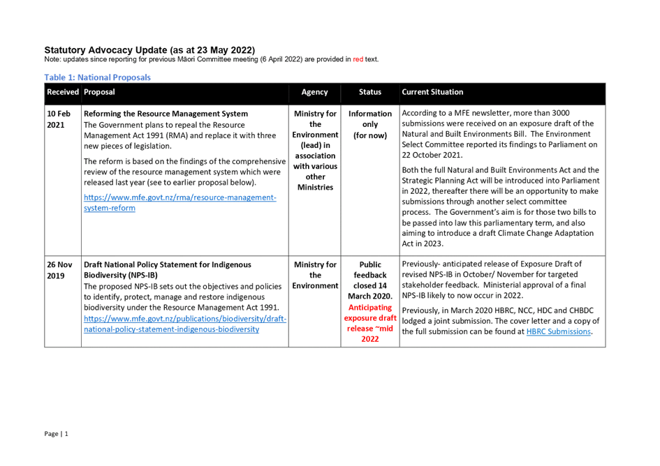
Meeting of the
Hawke's Bay Regional Council Māori Committee
Date: 8 June 2022
Time: 11.30am
|
Venue:
|
Council
Chamber
Hawke's
Bay Regional Council
159
Dalton Street
NAPIER
|
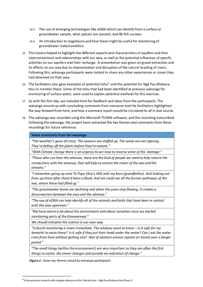
Agenda
Item Title Page
1. Welcome/Notices/Apologies
2. Conflict
of interest declarations
3. Alternate
member for 8 June 2022 meeting 3
4. Confirmation of Minutes of
the Maori Committee meeting held on 6 April 2022
5. Follow-ups
from previous Māori Committee meetings 5
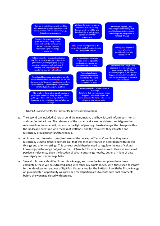
6. Introduction/welcome
to new NKII chair, Bayden Barber
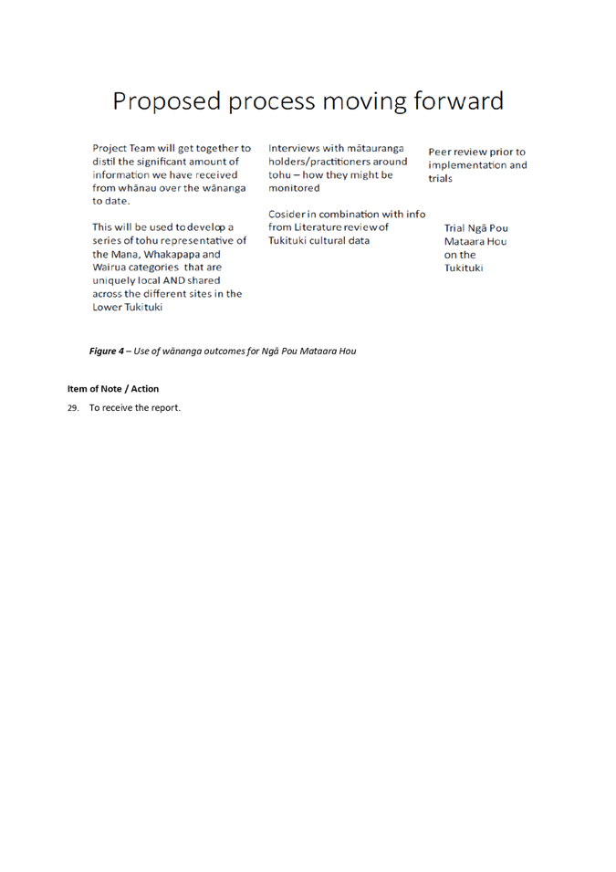
7. Take
Ripoata ā Takiwā – Taiwhenua representatives' updates 21
8. HBRC
Chair and Chief Executive's verbal updates on current issues
9. Kaitiaki
Board presentation by Paul Ratapu
10. Call
for minor items not on the Agenda 33
Decision
Items
11. Governance
support for development of the Kotahi Plan 35
12. Operational
Land Asset Policy 47
Information
or Performance Monitoring
13. Regional
Water Security Programme update 93
14. 3D
Aquifer Mapping project status update (SkyTEM) 117
15. June
2022 Statutory Advocacy update 125
16. Reports
from Regional Council and Committee meetings 133
17. Significant
organisational activities looking forward through June 2022 137
18. Partnership
survey 149
19. Discussion
of minor items not on the Agenda 153
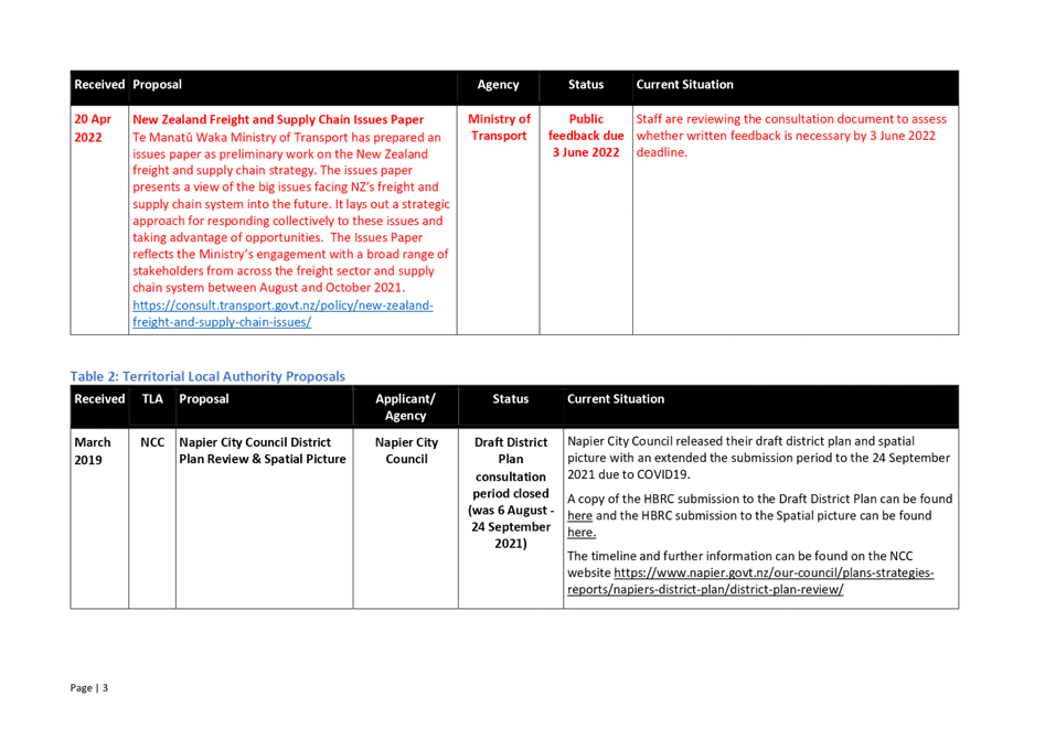
Parking
1.
Free
2-hour on-road parking is available on Vautier Street adjacent to the HBRC
Building & on Raffles Street.
2.
There
is free all day parking further afield – on Munroe Street or Hastings
Street by Briscoes.
3.
There
are limited parking spaces (3) for visitors in the HBRC car park – entry
off Vautier Street – it would be appropriate that the
“visitors” parks be available for the members travelling distances
from Wairoa and CHB.
4.
If
you do pay for parking elsewhere, please provide your receipt to the
Receptionist for reimbursement – or include with your expenses claim for
the meeting.
NB: Any
carparks that have yellow markings are NOT to be parked in please.
Hawke’s Bay Regional
Council
Māori
Committee
8 June
2022
Subject: Alternate member for 8 June
2022 meeting
Reason for Report
1. The Māori Committee
Terms of Reference makes allowance for short term replacements (proxy) to be
appointed to the Committee where the usual member/s cannot attend.
Recommendation
That __________________ be appointed as a member
of the Māori
Committee for
the meeting of 8 June 2022 as a short term replacement on the Committee
for ____________.
Authored by:
|
Annelie Roets
Governance Advisor
|
|
Approved by:
|
Pieri Munro
Te Pou Whakarae
|
|
Hawke’s Bay Regional
Council
Māori
Committee
8 June
2022
Subject: Follow-ups from previous
Māori Committee meetings
Reason for Report
1. Attachment 1 lists items raised
at previous meetings that require follow-up, who is responsible, when it is
expected to be completed and a brief status comment. Once the items have been
reported to the Committee they will be removed from the list.
Decision
Making Process
2. Staff have assessed the
requirements of the Local Government Act 2002 in relation to this item and have
concluded that, as this report is for information only, the decision-making
provisions do not apply.
Recommendation
That the Māori
Committee receives and notes the Follow-ups from previous Māori
Committee meetings.
Authored by:
|
Annelie Roets
Governance Advisor
|
|
Approved by:
|
James Palmer
Chief Executive
|
|
Attachment/s
|
1⇩
|
Follow-ups for June 2022 Maori Committee
|
|
|
|
Follow-ups for June 2022 Maori Committee
|
Attachment
1
|
Hawke’s Bay Regional
Council
Māori
Committee
8 June
2022
Subject: Take
Ripoata ā Takiwā – Taiwhenua representatives' updates
Reason for Report
1. This item provides the
opportunity for representatives of the four Taiwhenua (Te
Whanganui-a-Orotū, Tamatea, Wairoa/Kahungunu Executive and Heretaunga) to
raise current issues of interest in their rohe for discussion as per the
reports attached.
Decision Making Process
2. Staff have assessed the
requirements of the Local Government Act 2002 in relation to this item and have
concluded that, as this report is for information only, the decision-making
provisions do not apply.
Recommendation
That
the Māori
Committee receives and notes the Take ripoata ā takiwā – Taiwhenua reports.
Authored by:
|
Annelie Roets
Governance Advisor
|
|
Approved by:
|
Pieri Munro
Te Pou Whakarae
|
|
Attachment/s
|
1⇩
|
Te Taiwhenua o Heretaunga Taiwhenua
report - Marei Apatu
|
|
|
|
2⇩
|
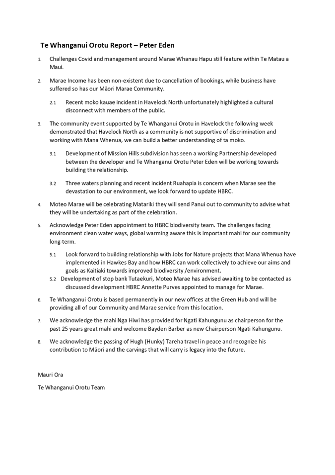
Te Whanganui Orotu Report - Peter
Eden
|
|
|
|
Te Taiwhenua o Heretaunga Taiwhenua
report - Marei Apatu
|
Attachment
1
|
|
Te Whanganui Orotu Report - Peter Eden
|
Attachment
2
|
Hawke’s
Bay Regional Council
Māori
Committee
8 June
2022
Subject: Call for minor items not on
the Agenda
Reason for
Report
1. This item provides the
means for committee members to raise minor matters they wish to bring to the
attention of the meeting.
2. Hawke’s Bay Regional
Council standing order 9.13
states:
2.1 “A meeting may discuss an
item that is not on the agenda only if it is a minor matter relating to the
general business of the meeting and the Chairperson explains at the beginning
of the public part of the meeting that the item will be discussed. However, the
meeting may not make a resolution, decision, or recommendation about the item,
except to refer it to a subsequent meeting for further discussion.”
Recommendation
That the Māori Committee accepts
the following minor items not on the Agenda for discussion as Item 19.
Authored by:
|
Annelie Roets
Governance Advisor
|
|
Approved by:
|
James Palmer
Chief Executive
|
|
Attachment/s
There are no attachments for this
report.
Hawke’s Bay Regional
Council
Māori
Committee
8 June
2022
Subject: Governance support for
development of the Kotahi Plan
Reason for Report
1. At the All Governors
wānanga on the 13 April 2022 Hawke’s Bay Regional Councillors,
Māori Committee members and Regional Planning Committee Post Settlement
Governance Entities (‘the Governors’) agreed to work in partnership
to develop our Regional Resource Management Plan – Kotahi.
2. A formal commitment is
sought from the Māori Committee via this paper for this All Governors
approach to support the development of Kotahi, as well as seeking a commitment
for the endorsement from the Māori Committee with regards to decision
making. Similarly, a commitment is sought from the Regional Planning Committee
at their meeting on the 15 June 2022.
Officers’
Recommendation
3. Officers are seeking a
formal commitment from the Māori Committee to work in partnership with the
Elected Members (Councillors) and Post Settlement
Governance Entities (PSGE)of the Regional Planning Committee (RPC) to lead
out the Kotahi engagement with tāngata whenua and the community.
4. Officers are seeking a
formal commitment from the Māori Committee to work in partnership with
officers, Elected Members, Post Settlement Governance Entities, such that the
Māori Committee will consider and endorse to the Regional Planning
Committee the decisions that are required to progress the development of the
plan through to notification.
5. Officers are seeking
support for the diarising of the All Governors hui to enable workshops and
decision-making.
Executive
Summary
6. At the All Governors
wānanga on 13 April 2022 Hawke’s Bay Regional Councillors,
Māori Committee members and Regional Planning Committee Post Settlement
Governance Entities agreed to work in partnership to develop our Regional
Resource Management Plan – Kotahi.
7. A formal commitment is now
sought for this All Governors approach. This requires a commitment from
Governors to be involved in takiwā engagement with tāngata whenua and
the community, leading the initial engagement alongside staff in the community
and making critical decisions to support the plan options and plan
notification. This will be the first pou in the ground for Kotahi governance, a
first marker of how we are going to work together.
8. It is important to note
that a similar paper is being also presented to the RPC later this month. The
items for decision within this item reflect a governance structure which is for
both tāngata whenua Governors and tāngata Tiriti Governors. The mana
and integrity of each Committee remains intact, however, it is imperative that
the governance for Kotahi is cemented so that the entire Hawke’s Bay
community is represented in the Plan. This governance structure acknowledges
that as Governors, representation and accountability is not just to those parts
of the community that have provided individuals with the mandate to be part of
their respective committees, but to the community as a whole.
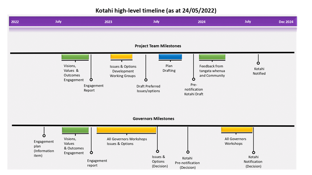
9. Attached to this item is
the Kotahi high level engagement timeline. This is intended to set out the
critical milestones for engagement and decision-making for Governors - as
discussed at the hui in April.
10. Furthermore, this paper is
seeking expressions of interest from Governors to be champions on the
environmental topic working parties - again this was discussed at the
wānanga in April.
Background
/Discussion
11. Kotahi will be the new
resource management plan for Hawke’s Bay and will combine the Regional
Policy Statement, Regional Resource Management Plan and Regional Coastal
Environment Plan. Having one plan supports a holistic, ki uta ki tai (mountains
to sea) approach to managing our natural and physical resources. Kotahi will
provide the direction for managing land and freshwater, air, coastal and marine
environment, natural hazards, climate change, biodiversity, energy, transport
and infrastructure and our urban environment.
12. In addition to the review
of these plans, under the Government’s Essential Freshwater Programme new
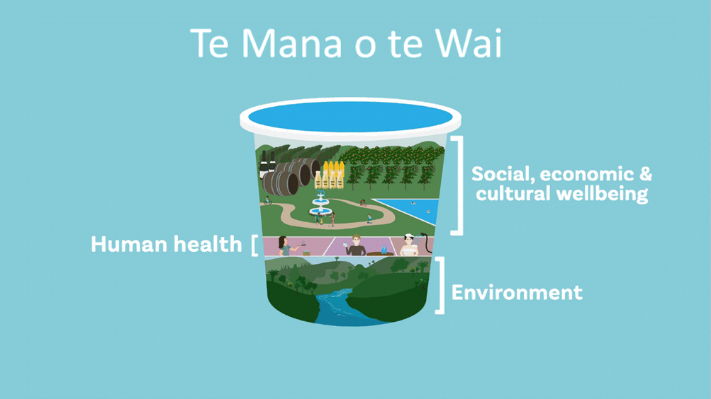
freshwater plans must be prepared that give effect to Te Mana o Te Wai. The National
Policy Statement for Freshwater Management 2020 requires these freshwater plans
to be notified by December 2024. Because of this deadline, which has been set
by the Government, there is a need to deliver Kotahi within a reasonably short
timeframe. Over the next three years the plan will be developed, with
engagement with tāngata whenua and the community being the initial focus
of this work.
13. Kotahi will provide the
policies and rules for how we manage the region’s natural and physical
resources. The first step in the plan development process will require
engagement with tāngata whenua and the community to understand the issues
within the environment and the environmental outcomes which are being sought,
taking a ki uta ki tai approach to environmental management through a broad but
interconnected set of planning instruments.
The
role of the Governors in the takiwā
14. At the All Governors
wānanga on the 13 April 2022 Hawke’s Bay Regional Councillors,
Māori Committee members and Regional Planning Committee Post Settlement
Governance Entities agreed to work in partnership to develop Kotahi. This
agreement extended to providing support for this critical mahi through
attendance at key meetings/hui to launch Kotahi and engage with tāngata
whenua and the community within the takiwā.
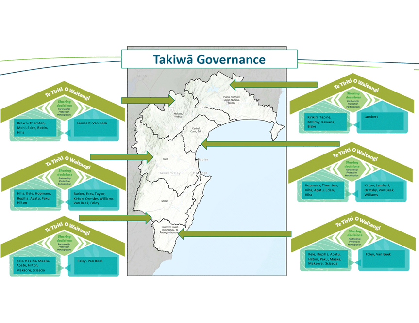
15. This was presented in draft
as ‘Takiwā Governance’ (attachment 2) at the hui and
identified the respective Councillors, Māori Committee members and PSGE
representatives for each of the takiwā based on taiwhenua, settlement and
constituency boundaries. There was an indication at the hui that the Governors
who had been identified in the slide required further discussion and agreement,
particularly with respect to the PSGE representatives and Māori Committee
members. It was agreed that this would be discussed and determined
‘off-line’ amongst the tāngata whenua Governors. This is to
occur without any input or direction through a formal committee process.
16. Once determined, it is
anticipated that through this engagement the Governors will work together,
listening to our communities to understand what they value about their
environment and what the issues are in the takiwā. The information and
feedback from the engagement will inform the development of solutions to affect
positive change and clearly set out a vision for our Hawke’s Bay
environment in the Plan.
17. It is important to note
that staff will support the Governors in this engagement process. They
will be developing supporting information for circulation in advance so that
Governors have the necessary information to support their involvement in
meetings, and to ensure that they are kept abreast of the topics and issues
within the takiwā and region.
18. A further commitment made
by Hawke’s Bay Regional Council at the April wānanga was to resource
technical advisors to mana whenua. These technical advisors will work alongside
staff to undertake the operational mahi which is required to ensure Kotahi
meets its legislative requirements. Again, the appointment and selection of
these advisors will be determined by the tāngata whenua Governors and does
not require a formal decision to be made through committee. This resource will
be fundamental to the success of the plan development; it is not expected that
the Governors will have the capacity to be involved in the day-to-day
operational activity and this technical resource will ensure that the Māori
world view is represented in the plan.
19. Hawke’s Bay Regional
Council will continue to hold discussions with the Ministry for the Environment
requesting Government funding to support this element of the process. It will
also explore alternative resources and methods of support for mana whenua such
as capability building.
20. Regardless of whether
additional funds become available from Government it should be noted that the
budgets set within the current Long Term Plan for both the Policy and Planning
workstream and Māori Partnerships will continue to be utilised. It is
acknowledged that the Māori Committee and Regional Planning Committee
members will be remunerated for their involvement in this engagement process in
recognition for their time, effort and expertise.
The
Role of Māori Committee in Decision-making
21. As discussed at the hui in
April, the role of the Māori Committee is essential to the success of both
the engagement and decision-making required to support the plan development.
The taiwhenua have strong links at marae and hapū level, which are
incredibly important in terms of ensuring mana whenua are connected to the
process, are able to be involved in setting the values and visions, have an
opportunity to engage, have an understanding of the issues, and in how Kotahi
proposes to address the environmental issues and deliver the environmental
outcomes. The Māori Committee members will be very much at the
‘grass roots’ of the conversations with mana whenua. They will be
an important connector between Hawke’s Bay Regional Council and the
Māori community.
22. To ensure that mana whenua
is actively involved in the plan development for Kotahi it is imperative that
the Māori Committee members have a role alongside the Councillors and PSGE
representatives in the decision-making. Although it is acknowledged that the
Hawke’s Bay Regional Planning Committee Act provides the RPC members with
a formal decision-making role, through the All Governors hui it has been agreed
that the Māori Committee will have the role of endorsing decisions prior
to the RPC and Council formalising decisions through Committee. This
endorsement by the Māori Committee strengthens the role of the taiwhenua
members in determining the plan direction. It retains the integrity of the
Māori Committee as its own entity, but now seeks to draw on the strength
of the taiwhenua working alongside the RPC. This is a crucial step in order to
recognise the Māori Committee’s mana as Treaty Partners and
Governors and to obtain ratification of the plan throughout the various stages
of the process.
23. As such it is intended to
unite the two committees (Māori Committee and RPC) through the creation of
the All Governors hui within the Committee calendar specifically for Kotahi
workshops and decision-making. A draft calendar of All Governors hui meeting
dates is appended to this report (attachment 3).
Topic
Champions
24. The identification of
‘topic champions’ was also discussed at the hui and received
support. Staff will be calling for expressions of interest for Governors to
champion a topic. The champions will be expected to attend working party
meetings to discuss issues, be a conduit for takiwā leaders to bring
issues to the working parties, and bring options and solutions back to the All
Governors meetings for decisions to be made. This will be additional work over
and above the takiwā engagement.
Strategic Fit
25. The four pillars of the
Strategic Plan - Land and Freshwater, Biodiversity, Infrastructure and
Services - are all aspects which will form part of Kotahi. The objective to
embed tāngata whenua values for all catchments in the resource management
plan by 2025 will be met through the development of Kotahi. The support from
the Māori Committee in the engagement and decision-making for the plan
will ensure that this strategic objective is met in way that is appropriate and
respects Te Ao Māori.
Significance
and Engagement Policy Assessment
26. The decisions
requested of the Committee are not significant in terms of Council’s
Significance and Engagement Policy and do not require further consultation with
the wider community.
Financial
and Resource Implications
27. As noted above the resource
requirements to support technical advisors (consultants or staff within
existing employment to the PSGE or taiwhenua) is acknowledged and a commitment
was made at the April hui for HBRC funding to support this.
28. The details of the funding
available has not yet been confirmed as there are ongoing discussions with the
Ministry for the Environment as to whether there is Government funding which
might be forthcoming to support this element of the process. Should additional
funds not be available then the budgets set within the current Long Term Plan
for both the Policy and Planning workstream and the Māori Partnerships
budgets will be used.
Decision Making Process
29. Council and its committees
are required to make every decision in accordance with the requirements of the
Local Government Act 2002 (the Act). Staff have assessed the requirements in
relation to this item and have concluded:
29.1. The decision does not
significantly alter the service provision or affect a strategic asset, nor is
it inconsistent with an existing policy or plan.
29.2. The use of the special
consultative procedure is not prescribed by legislation.
29.3. The decision is not
significant under the criteria contained in Council’s adopted
Significance and Engagement Policy.
30. Given the nature and
significance of the issue to be considered and decided, and also the persons
likely to be affected by, or have an interest in the decisions made, the
Māori Committee can exercise its discretion and make these decisions
without consulting directly with the community or others having an interest in
the decision.
Recommendations
That the Māori Committee:
1. Receives and considers the Governance
support for development of the Kotahi Plan staff report.
2. Agrees that the decisions
to be made are not significant under the criteria contained in Council’s
adopted Significance and Engagement Policy, and that the Committee can exercise
its discretion and make decisions on this issue without conferring directly
with the community or persons likely to have an interest in the decision.
3. Agrees to work in
partnership with the elected members (councillors) and Post Settlement
Governance Entities of the Regional Planning Committee to:
3.1. lead out the Kotahi
engagement with tāngata whenua and the community in the takiwā
3.2. consider and endorse the
decisions which are required to progress the development of the Kotahi Plan
through to notification
3.3. combine the Māori
Committee and Regional Planning Committee meetings to form an All HBRC
Governors group to workshop
and make decisions on Kotahi.
Authored by:
|
Ceri Edmonds
Manager Policy & Planning
|
|
Approved by:
|
Katrina Brunton
Group Manager Policy &
Regulation
|
Pieri Munro
Te Pou Whakarae
|
Attachment/s
|
1⇩
|
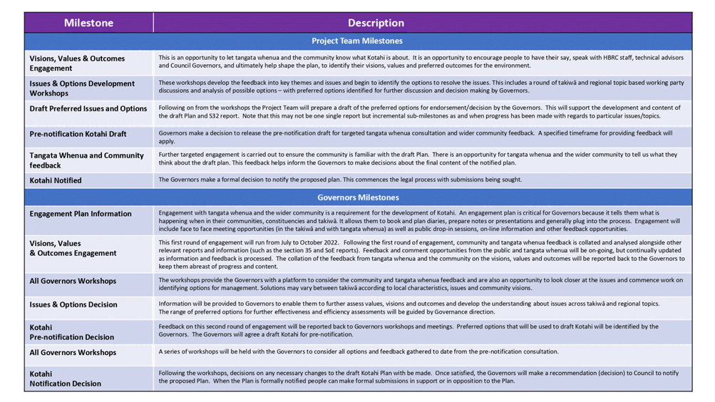
Kotahi high level timeline
|
|
|
|
2⇩
|
Takiwa Governance
|
|
|
|
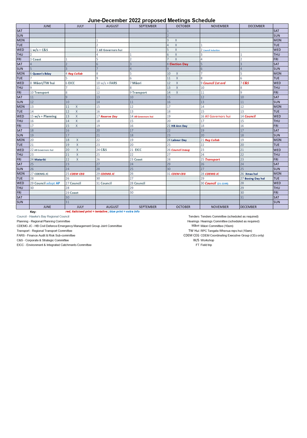
3⇩
|
June-December 2022 proposed schedule
|
|
|
|
Kotahi high level timeline
|
Attachment
1
|
|
Takiwa Governance
|
Attachment
2
|
|
June-December 2022 proposed schedule
|
Attachment
3
|
Hawke’s
Bay Regional Council
Māori
Committee
8 June
2022
Subject: Operational
Land Asset Policy
Reason for Report
1. This item seeks the
endorsement of the Māori Committee for Council to adopt the Operational
Land Asset Policy.
Executive
Summary
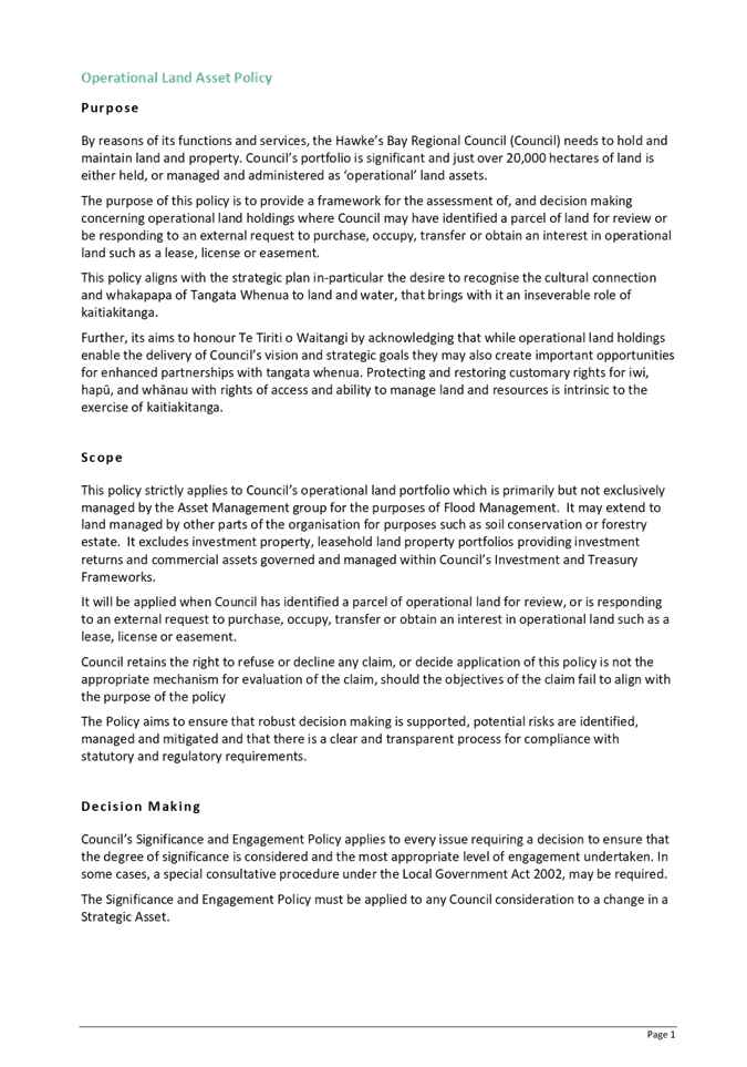
2. This is a new Council
policy, created to provide a framework for the assessment of and decisions on
claims for the transfer of operational land holdings.
3. The policy does not signal
a review or changed position from the status quo on HBRC’s operational
land holdings, but merely provides staff a mechanism for reviewing requests
that are received from time to time.
4. The policy may be used when
Council has identified a parcel of land for review, or is responding to an
external request to purchase, occupy, transfer or obtain an interest in
operational land such as a lease, licence or easement.
5. The policy considers key
criteria when assessing any land or property asset and aligns with the
strategic plan, in particular the desire to recognise the cultural connection
and whakapapa of tangata whenua to land and water, that brings with it an
inseverable role of kaitiakitanga.
6. The policy applies to
Council’s operational land portfolio which is primarily, but not
exclusively, managed by the Asset Management group for the purposes of flood
management. It may extend to land managed by other parts of the
organisation for purposes such as soil conservation or forestry estate. It
excludes investment property, leasehold land property portfolios providing
investment returns, and commercial assets governed and managed within
Council’s investment and treasury frameworks.
7. Council retains the right
to refuse or decline any claim, or decide that the application of this policy
is not the appropriate mechanism for evaluation of the claim, should the
objectives of the claim fail to align with the purpose of the policy.
Funding
and Resourcing the Business Case preparation
8. The policy presented
includes a proposed business case framework. The cost of preparing business
case(s) and the subsequent staff time contributing towards decision making will
require funding. There is currently no dedicated funding within current
work programmes.
9. It is proposed the business
cases be prepared internally by Council staff and funded by Council up to
$20,000 per business case. Many historical land ownership right matters
are complex and will also require external consultancy advice and expertise.
10. The development of a business case
could vary significantly depending on the complexity of the land
ownership. In more complex cases the cost could be as much as $30k - $40k
per business case. A number of options available for consideration for
funding the costs include:
10.1. The requestor funds the costs
10.2. Council funds the costs – either
charged to the scheme in which the land resides, or to the Governance and Partnerships
cost centre
10.3. The cost is shared between the
requestor and Council, by either ratio or cap where Council funds the first
$10,000 or $20,000.
11. To manage Council resources, both
people and financial, staff recommend including limits to the policy whereby
only one request or business case is accepted for preparation by staff at any
given time.
12. The policy has been drafted with a
staff recommendation of shared costs, where Council funds the first $20,000
towards development of the business case, for Committee consideration.
Significance
and Engagement Policy assessment
13. This policy is a decision-making
framework and in itself does not trigger consultation in accordance with the
Significance and Engagement Policy.
14. It is possible that a recommendation
by staff on a particular land holding may trigger the Significance and
Engagement Policy and, if that is the case, then the requirements of that
policy will be met.
Climate
Change considerations
15. Land may be held by HBRC for strategic
purposes which may include for flexibility in managing schemes or assets with
respect to the impact of climate change.
Considerations
of Tangata Whenua
16. A determinant for the drafting of this
Policy is four independent tangata whenua requests that Council has received,
some dating back to early 2018. These relate to specific parcels of
Council’s operational land holdings at Pōrangahau, Roys Hill –
Ngatarawa, Waiōhiki and Ōhiti. Each of these requests will require
extensive investigation, research and consultation with potential for a
business case to Council.
17. Council’s desire and commitment
is to achieve a close partnered working relationship with its Tīriti
partner. That becomes evident in the co-governance and legislated relationship
of Council with ten post-settlement governance entities across Te Matau a
Māui region. Also, in the Māori Committee of Council and its enduring
25yr+ relationship with Ngāti Kahungunu Iwi through four of six Taiwhenua
within the region.
18. Council recognises and acknowledges
its Māori Committee and Regional Planning Committee. It is anticipated
that this agenda item and draft policy, prior to its finalisation, will be brought
before each of those committees for consideration and endorsement.
Financial
and Resource Implications
19. The financial impact of any
individual claim, on either Council income (annualised) or balance sheet, is
expected to be immaterial based on the level of materiality, which during the
FY20-21 audit was deemed to be $100k by Audit NZ.
20. For context as at 30 June
2021, annual income from grazing leases on infrastructure land totals $90k per
annum. Significant assumptions used in land valuation value floodable
land that is grazed at $6k per annum, and floodable land that is not grazed at
nil.
21. However, for larger land
holdings where divestment is being requested or considered, the financial
impact may be more significant. The financial impact on income, and
therefore on funding of Council operations and balance sheet treatment and
impact, will be assessed on a case-by-case basis. Council’s
standard decision-making processes apply to every decision made. If the
financial impacts are assessed as significant or the asset is strategic,
Council may need to consult ahead of making a formal decision.
22. Current Infrastructure land valuations
are based on a 2017 valuation and are due for revaluation. Staff are
progressing the revaluation of infrastructure land assets in parallel with
development of this policy. Current valuations as at 30 June 2022 will be
available for business case assessment, and to ensure that these land asset
values are not misstated within financial statements.
Decision Making Process
23. Council and its committees are
required to make every decision in accordance with the requirements of the
Local Government Act 2002 (the Act). Staff have assessed the requirements in
relation to this item and have concluded:
23.1. The decision does not
significantly alter the service provision or affect a strategic asset, nor is
it inconsistent with an existing policy or plan.
23.2. The use of the special
consultative procedure is not prescribed by legislation.
23.3. The decision is not significant
under the criteria contained in Council’s adopted Significance and
Engagement Policy.
23.4. Given the nature and
significance of the issue to be considered and decided, the Committee can
exercise its discretion and make a decision recommendation to Council without
consulting directly with the community.
Recommendations
1. That the Māori
Committee receives and considers the Operational Land Asset Policy staff
report.
2. The Māori Committee
recommends that Hawke’s Bay Regional Council:
2.1. Agrees that the decisions
to be made are not significant under the criteria contained in Council’s
adopted Significance and Engagement Policy, and that Council can exercise its
discretion and make decisions on this issue without conferring directly with
the community or persons likely to have an interest in the decision.
2.2. Adopts the Operational
Land Asset Policy as endorsed by
the Māori Committee.
Authored by:
|
Jessica Ellerm
Programme Director
|
Pieri Munro
Te Pou Whakarae
|
Approved by:
|
Chris Dolley
Group Manager Asset Management
|
|
Attachment/s
|
1⇩
|
Operational Land Asset Policy 1 June
2022
|
|
|
|
Operational Land Asset Policy 1 June 2022
|
Attachment
1
|


Hawke’s
Bay Regional Council
Māori
Committee
8 June
2022
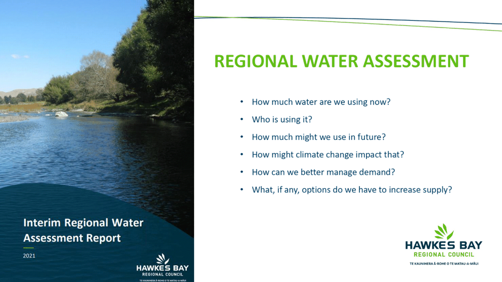
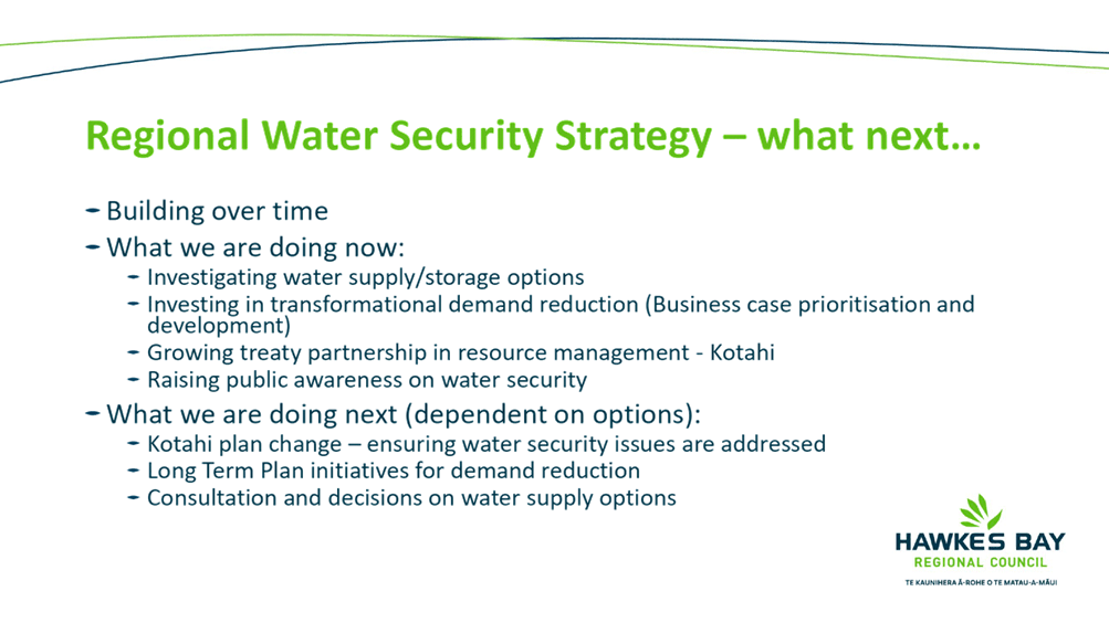
Subject: Regional Water Security
Programme update
Reason for Report
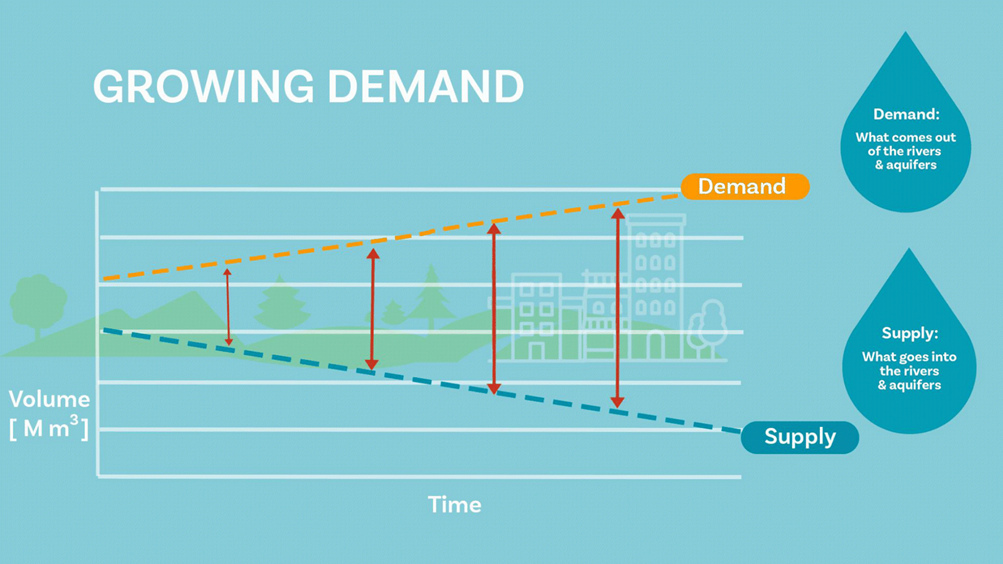
1. This item introduces the
presentation as attached.
Decision Making Process
2. Staff have assessed the
requirements of the Local Government Act 2002 in relation to this item and have
concluded that, as this report is for information only, the decision making
provisions do not apply.
Recommendation
That the Māori Committee receives and
notes the Regional Water Security Programme update.
Authored by:
|
Amanda Langley
Projecthaus
|
Tom Skerman
Regional Water Security Programme
Director
|
Approved by:
|
Chris Dolley
Group Manager Asset Management
|
|
Attachment/s
|
1⇩
|
Regional Water Security Programme
Update
|
|
|
|
Regional Water Security Programme Update
|
Attachment
1
|
Hawke’s Bay Regional
Council
Māori
Committee
8 June
2022
Subject: 3D Aquifer Mapping project
status update (SkyTEM)
Reason for Report
1. This report provides a
status update on the 3D Aquifer Mapping Project, including revisiting the
objectives and outcomes sought, timeframes and partners involved.
Introduction and Executive Summary
2. The
Hawke’s Bay 3D Aquifer Mapping Project (3DAMP) is a three-year initiative
(2019–2022) jointly funded by the Provincial Growth Fund (PGF),
Hawke’s Bay Regional Council (HBRC) and GNS Science (GNS). The project
applies Airborne Electromagnetic technology (SkyTEM) to improve mapping and
modelling of groundwater resources within the Heretaunga Plains, Ruataniwha
Plains and Poukawa and Otane Basins. 3DAMP involves collaboration between HBRC,
GNS and the Aarhus University HydroGeophysics Group (HGG). The programme is
also supported with specialist project management services from Project Haus.
3. Between
January and February 2020, electromagnetic surveys were flown by SkyTEM
Australia over the Heretaunga Plains, Ruataniwha Plains and Poukawa and Otane
Basins. GNS have completed processing and modelling of all SkyTEM data. This
work involved removing data impacted by electromagnetic noise and developing
resistivity models. Work is underway to interpret basin-wide hydrogeological
characteristics using the resistivity models and supporting data. Completion of
this work is planned in stages based on the areas surveyed. This report
provides an update on these work programmes.
3D Aquifer Mapping Project Background
4. The concept of using SkyTEM
to map regionally significant groundwater resources was first proposed by HBRC
staff during development of the Heretaunga groundwater model. This led to
discussions between GNS and HBRC on the potential application of airborne
electromagnetic (AEM) technology for groundwater mapping.
5. In 2017, following
discussions with GNS, a proposal for an AEM survey was presented to Council as
part of Science’s business case for the Long-Term Plan (LTP). This
business case proposed to deliver a high-resolution geophysical dataset for the
entire Heretaunga Plains aquifer system. At the request of the Regional
Planning Committee (RPC) this was extended to include the Ruataniwha Basin and
was adopted in the 2018-2028 LTP.
6. In 2018 and 2019, HBRC
engaged GNS and Project Haus to carry out planning for the SkyTEM survey and to
develop a strategy for all tasks required for processing, modelling, and
interpretation of SkyTEM data, including refinement of groundwater knowledge
and information (such as refining hydrogeological and groundwater
models).
7. During 2019, with
assistance from GNS and Project Haus, HBRC applied to the PGF for funding. The
application included surveying the Poukawa and Otane Basins in addition to the
Heretaunga and Ruataniwha Plains. This was notified as successful in June 2019.
In October 2019, SkyTEM Australia Pty Ltd was contracted by HBRC to acquire AEM
data using SkyTEM technology. This survey was flown between January and
February 2020.
3D
Aquifer Mapping Project – Why are we doing this project?
8. The 3D Aquifer Mapping
Project seeks to improve mapping and characterisation of groundwater resources
in the Heretaunga and Ruataniwha Plains, and in the Otane and Poukawa Basins.
Aquifer mapping is traditionally based on well drilling, however, scarcity of
lithological logs (particularly at depth or over difficult terrain) and
low-quality of logging means existing lithological information is often missing
or insufficient to fully capture regional and local-scale hydrogeological
structures. This, coupled with the high cost associated with drilling and the
high cost of professionally logging exploration wells, means characterising
groundwater systems with a dedicated drilling programme is neither practical
nor feasible.
9. Aerial Electromagnetic data
provides a cost-effective, non-invasive data collection method to map large
areas with a higher density of data coverage and the ability to cover areas
with rugged terrain with minimal impacts to local activities. AEM data,
combined with existing borehole data, provides considerable improvement in the
understanding the hydrogeologic framework. Hydrogeologic frameworks provide the
basis for understanding how groundwater systems work, such as where aquifers
are confined/unconfined, where areas are prone to land surface contamination,
how far and deep aquifers extend, and the composition of aquifer materials.
This information is fundamental in developing quantitative tools such as
numerical groundwater models which are used to assess the effects or resource
activities on groundwater and surface water resources. The more accurately we
can represent the real-world system the more certain our predictions become,
and the better we manage the resource.
Summary of the work programme
10. The
work programme for the 3D Aquifer Mapping project commenced September 2019 and
completion is planned for June 2023. Key milestones are:
10.1. Complete
airborne electromagnetic surveys of the Heretaunga, Ruataniwha and
Otane/Poukawa aquifer surveys (completed)
10.2. Develop
quality assured resistivity models using the SkyTEM data (completed)
10.3. Undertake
a simple groundwater-relevant assessment of the resistivity models for
Heretaunga Plains, Ruataniwha Plains and Otane/Poukawa Basin (work
in progress)
10.4. Complete
a more complex groundwater-relevant assessment of the resistivity models for
Heretaunga Plains and Ruataniwha Plains considering factors such as confinement
status and groundwater-surface water interaction (i.e., clay fraction models) (work
in progress)
10.5. Develop
Hydrogeological Models using the resistivity data and interpretations for
Heretaunga Plains and Ruataniwha Plains (work in
progress)
10.6. Refine
numerical groundwater models using the resistivity data and interpretations for
Heretaunga Plains (work in progress).
3D
Aquifer Mapping Project – Update on deliverables
Otane and
Poukawa Basins
11. GNS
Science, in collaboration with Aarhus University in Denmark, have processed,
and modelled the SkyTEM data collected from the Poukawa and Otane Basements.
This involved removing electromagnetic noise and artefacts from the SkyTEM
dataset and creating a detailed three-dimensional model of how the
electromagnetic signal flows through the ground.
12. A
report detailing this work has been published and made available online. A
second report interpreting the resistivity models has been reviewed by Council
and is currently with GNS for final signoff.
13. The
SkyTEM survey reveals a detailed 3D resistivity picture of the subsurface,
which in some locations extends down to 490 metres below land surface. The
resistivity data has been used to delineate the Poukawa and Otane basins into
three major hydrogeological units (HU) of which two of these units are further
split into two hydrogeological subunits (sub-HU). The delineations provide
significant refinement of the existing understanding of groundwater resources
in the Poukawa and Otane basins.
Heretaunga Plains
14. GNS
Science, in collaboration with Aarhus University in Denmark, have processed and
modelled the SkyTEM data collected from the Heretaunga Plains. A report
detailing this work has been published and made available online. A second
report interpreting the resistivity models has been reviewed by Council and is
currently with GNS for final signoff. This is likely to be completed end of
June 2022.
15. The
resistivity models identify resistivity structures associated with changes in
lithology, such as depth to basement, geological layering, and the extent of
the Ngaruroro River gravel aquifer system over the Heretaunga Plains.
16. This
programme of work is supported by a data collection programme which included
drilling an exploratory well on Morely Road at Tomoana, Hastings. Drilling was
completed in March 2021 and datasets were reported in December 2021. A summary
of drilling information and additional data available for assisting
interpretations were collated in a separate report delivered in January 2022.
17. GNS
Science is close to completing hydrogeological interpretations for the
Heretaunga Plains using a combined approach of manually picking geological
boundaries through visual assessments of data (manual delineation) and
automated modelling using different statistical approaches.
18. Aarhus
University from Denmark have developed hydrostratigraphic models using the
resistivity models and available lithological logs. This information determines
the clay fraction for different depth intervals. The amount of clay provides
information about the permeability of the groundwater system, i.e., whether the
materials are likely to be confining or not. The method produces multiple
realisations which can be used to assist with uncertainty analysis within
groundwater flow modelling.
19. An
example showing a resistivity profile across the Heretaunga Plains and the
manually delineated surfaces used to define the major hydrogeological units is
shown below. Borehole data and surface geological maps provided calibration for
the hydrogeological units.
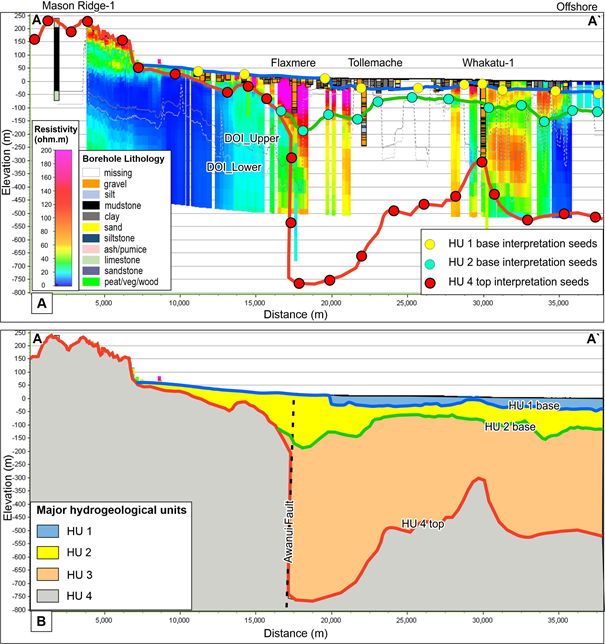
Figure 1.0: Example
of resistivity model and interpretations
Ruataniwha Plains
20. GNS
Science, in collaboration with Aarhus University in Denmark, finalised
processing and resistivity modelling for the Ruataniwha Plains in April 2022.
The resistivity model for the Ruataniwha Plains identify resistivity structures
associated with changes in lithology such as depth to basement and geological
layering. The results are being used to help inform the Ruataniwha Groundwater
model which is currently being development under a separate work programme.
21. The
resistivity interpretations are supported by a data collection programme which
was completed in October 2021. This involved drilling two exploratory wells on
the Ruataniwha Plains. Information obtained from drill cuttings will be used to
better understand how the SkyTEM data relates to lithology. Borehole reports
for this work are due in the next couple of months.
22. Work
is underway to interpret basin-wide hydrogeological characteristics from this
dataset. This work is scheduled to be finalised after completion of
interpretations for the Heretaunga Plains. A summary of drilling information
and additional data used to assist with interpretations is currently being
collated in a separate report due to be delivered July 2022.
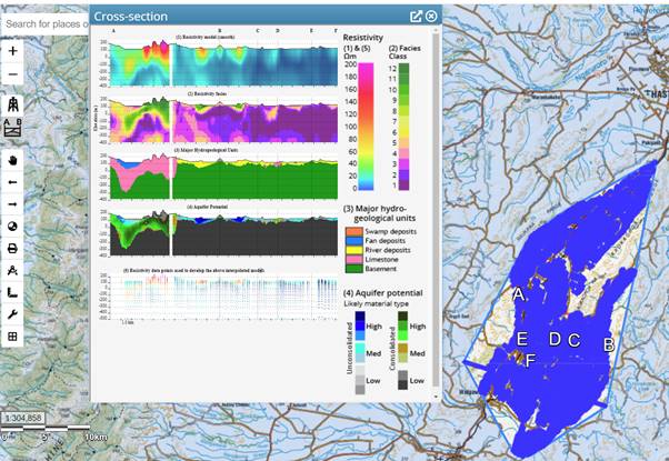
23. This
cross-section below shows a 2D view of the resistivity model in the Ruataniwha
Plains. Blue-green shows low resistivity (likely corresponding to fine-grained
material such as clay and silt) and yellow-red-purple shows high resistivity
(likely corresponding to coarser-grained material such as gravel and
limestone). Exact resistivity values differ by location as they are sensitive
to many properties, and so the meaning of the different resistivity values will
be assessed during the hydrogeological interpretation.
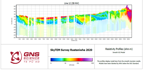
Figure 2.0. Example of output from the Ruataniwha Plains resistivity
model
Numerical groundwater modelling
24. The
SkyTEM data is being used to revise the Heretaunga Plains groundwater model.
The objective of this work is to quantify how SkyTEM data reduces model
uncertainty. The programme of work explores different methods for incorporating
SkyTEM data into our modelling programmes.
25. SkyTEM
data is also being used by GNS to refine localised groundwater models around
Bridge Pa. The objective of this work is to better understand the stressors
effecting flow in the Paritua Stream.
Deliverables and where to find results?
26. Reports
associated with the 3D Aquifer Mapping Project are available online and linked
to the Council’s 3D Aquifer Mapping website - https://www.hbrc.govt.nz/hawkes-bay/projects/3d-aquifer-mapping-project/.
27. Report
findings, along with an overview of the project, have been summarised and
published within an ESRI StoryMap through our 3D Aquifer Mapping website.
The StoryMap is being developed in stages aligning with the completion of
modelling and interpretations in each of the surveyed areas. The second release
on StoryMap will focus on summarising findings for the Heretaunga Plains. The
StoryMap provides an embedded tool for the public to interact with the results.
Figure
3.0: An example of the interactive webmap
available to the public on StoryMap
Timelines
for release of public information
|
Description
|
Milestone
|
Target
Completion date
|
|
Electromagnetic
Survey
|
SkyTEM survey
report
|
Completed
2020
|
|
Resistivity
modelling
|
3 x
SkyTEM processing and resistivity modelling reports
|
Completed
2022
|
|
Hydrogeological
modelling
|
Hydrogeological
models and reports
|
Heretaunga
Plains: July 2022
Ruataniwha
Plains: June 2023
|
|
Groundwater
flow and transport modelling
|
Heretaunga groundwater
model and report
|
June
2023
|
Decision
Making Process
28. Staff
have assessed the requirements of the Local Government Act 2002 in relation to
this item and have concluded that, as this report is for information only, the
decision-making provisions do not apply.
Recommendation
That the Environment and Integrated
Catchments Committee receives and notes the Update on the 3D Aquifer Mapping
Project (SkyTEM).
Authored by:
|
Simon Harper
Team Leader - Hydrology &
Groundwater Science
|
Anna Madarasz-Smith
Manager Science
|
Approved by:
|
Iain Maxwell
Group Manager Integrated Catchment
Management
|
|
Attachment/s
There are no attachments for this
report.
Hawke’s
Bay Regional Council
Māori
Committee
8 June
2022
Subject: June 2022 Statutory Advocacy
Update
Reason for Report
1. This item reports on
proposals forwarded to the Regional Council and assessed by staff acting under
delegated authority as part of the Council’s Statutory Advocacy project.
2. The Statutory Advocacy
project centres on local resource management related proposals upon which the
Regional Council has an opportunity to make comments or to lodge a
submission. These include, but are not limited to:
2.1. resource consent
applications publicly notified by a territorial authority
2.2. district plan reviews or
district plan changes released by a territorial authority
2.3. private plan change
requests publicly notified by a territorial authority
2.4. notices of requirements for
designations in district plans
2.5. non-statutory strategies,
structure plans, registrations, etc prepared by territorial authorities,
government ministries or other agencies involved in resource management.
3. In all cases, the Regional
Council is not the decision-maker, applicant nor proponent. In
the Statutory Advocacy project, the Regional Council is purely an agency with
an opportunity to make comments or lodge submissions on others’
proposals. The Council’s position in relation to such proposals is
informed by the Council’s own Plans, Policies and Strategies, plus its
land ownership or asset management interests.
4. The summary outlines those
proposals that the Council’s Statutory Advocacy project is currently
actively engaged in.
Decision Making Process
5. Staff have assessed the
requirements of the Local Government Act 2002 in relation to this item and have
concluded that, as this report is for information only, the decision-making
provisions do not apply.
Recommendation
That
the Māori
Committee receives and notes the June 2022 Statutory Advocacy report.
Authored by: Approved
by:
|
Nichola Nicholson
Intermediate Policy Planner
|
Ceri Edmonds
Manager
Policy & Planning
|
Attachment/s
|
1⇩
|
June 2022 Statutory Advocacy Update
|
|
|
|
June 2022 Statutory Advocacy Update
|
Attachment
1
|
Hawke’s Bay Regional
Council
Māori
Committee
8 June
2022
Subject: Reports from Regional Council
and Committee Meetings
Reason for Report
1. This item provides
information from recent meetings attended by Māori Committee
representatives, and the opportunity for the Committee to discuss any matters
of particular interest arising from those meetings.
Environment
and Integrated Catchments Committee (EICC)
2. Dr Roger Maaka represents
the Māori Committee on the EICC, which met on 11 May 2022 in Wairoa.
Highlights from the meeting are covered following.
2.1. A Mahia predator control
presentation was delivered by Terence Maru from the Rongomaiwahine Iwi
Trust. It covered a variety of projects currently being undertaken, their
strategic plan and the future direction of the Trust.
2.2. A Marae riparian
protection works presentation by Katarina Kawana covered awa restoration,
fencing, pest control and native nursery projects currently being undertaken.
The Wairoa awa restoration project has evolved from concern for the river; its
kaupapa is to raise awareness of the environment, the flora and fauna and
restoring the mauri of the awa.
2.3. The Integrated Catchment
Management response to recent flood events in Wairoa provided an update on
the activities undertaken by the ICM team in response to the impacts of recent
flooding in the Wairoa area including:
2.3.1. Immediate response taken by
HBRC staff during and following the flood event including follow up phone calls
made to farmers with a wellbeing focus
2.3.2. Working closely with the
Wairoa District Council which is the lead recovery agency for the event.
HBRC will continue to support the coordinated recovery that will be active for
many months and years to come once the formal recovery has concluded.
2.4. The Update on IRG Flood
Control Resilience funded projects item updated on the current status of
the four projects approved for funding as part of the Crown’s Flood
Control Resilience Funding with the Infrastructure Reference Group (IRG).
2.5. The River Managers
Special Interest Group business case item provided an update on work being
undertaken by the regional council sector to obtain ongoing central Government
co-investment in flood protection and river management schemes.
2.6. The Air Quality
Compliance with National Environmental Standards for Particulate Matter
item presented an assessment of the likelihood that Hawke’s Bay’s
urban airsheds and rural towns will be able to consistently meet existing air
quality standards, and whether these could comply with the proposed new
standards. Implications of the updated World Health Organisation (WHO)
air quality objectives and guidelines were also raised, noting:
2.6.1. Upgraded monitoring
instruments will be required in larger towns. Newer/more accurate
instruments are being progressively introduced in Napier and Hastings;
ultimately replacing the existing ones.
2.6.2. New air quality standards
for Hawke’s Bay communities will be developed through the Kotahi plan
change process.
2.7. The Coastal Bird Survey
results provided a summary of the results of a baseline survey of
indigenous bird values along the Hawke’s Bay coastline. Discussions
noted:
2.7.1. A total of 321km of
Hawke’s Bay coastline was surveyed in 1km sections and all bird and
marine mammal species counted.
2.7.2. A total of 79 bird species
and two marine mammal species were detected during this survey. 57 bird species
(72%) are native or endemic to New Zealand, and 28 of these species (35%) are
ranked as either Nationally Threatened or At Risk under the New Zealand Threat
Classification System.
2.7.3. Key findings of the survey
include that Hawke’s Bay supports 16% of the global population of
pohowera / banded dotterel, Tūturiwhatu
/ New Zealand dotterels have experienced a substantial increase in population
size and breeding range along the Hawke’s Bay coastline since 2011 due to
a successful species recovery plan, and Hākoakoa / sooty shearwaters were
re-discovered to be breeding on Te Motu-o-Kura /Bare Island.
Regional
Transport Committee (RTC)
3. Api Robin represents the
Māori Committee on the Regional Transport Committee, which is scheduled to
meet this coming Friday, 10 June and will discuss:
3.1. The Regional Passenger
Transport Plan review, with the focus of improved public transport across the
region
3.2. Communications with Waka
Kotahi (NZTA)
in
relation to State Highway 5 and the decision to reduce the speed limit to
80km/hr on a 76km section of it
3.3. Formalising representation
on the Regional Transport Committee for the active transport sector (cycling,
walking)
3.4. An update on the Gisborne
rail link.
Corporate
and Strategic Committee (C&S)
4. Peter Eden represents the
Māori Committee on the C&S, which met on 1 June 2022. Highlights from
the meeting include:
4.1. a recommendation to Council
to adopt the Annual Plan 2022-2023
4.2. a recommendation to Council
to participate in a Regional Sector Shared Services Council Controlled
Organisation
4.3. The Operational Land Asset
Policy
item provided a new policy which is to provide a framework for assessing claims
to transfer operational land holdings which the Committee recommended that
Council adopt with the endorsement of the Māori Committee and Regional Planning Committee. The consideration
of the policy by the Māori Committee is the subject of an item on
today’s Agenda.
4.4. The Organisational
Performance report and the Financial report for the period to
31 March 2022 highlighted:
4.4.1. New for the dashboard this
quarter is the Strategic Projects report with traffic light status for Risk,
Schedule and Budget, and a status commentary for the month of April. This is
the same content as in the Significant Activities Report that is received at
Council each month. This will be updated monthly in the dashboard.
4.4.2. New for the report
are a sample of measures from the new Customer Experience software (Zendesk).
See page 10 of the report.
4.4.3. In response to committee
member feedback, both LOSM and Activity reporting have been centrally reviewed
more closely to ensure consistency between traffic light status and commentary
and more accurately reflect known issues with for example, Covid-19 disruption.
As a result, there has been a shift from green to amber across both sections of
the report when compared to last quarter.
4.4.4. Electricity use at Guppy
Road, Wairoa and Raffles Street offices has been included in the report in addition
to the main office at Dalton Street, and fuel use by all HBRC vehicles,
including Works Group equipment/plant has been included.
4.4.5. The daily impacts of
Covid-19 continue to disrupt delivery and planning. While delivery for
most levels of service is on track to be achieved, some significant impacts to
large scale projects will not be recoverable this financial year.
4.4.6. The Long Term Plan (LTP)
capital work programme will require re-profiling across the remaining 8 years
of the 10-year plan horizon to account for changes to project scoping, building
internal capability and shifts in the external operating environment.
4.5. The HBRIC Ltd quarterly
update provided a quarterly update on the activities for the third
quarter of the 2021-2022 financial year.
4.5.1. Income has been as
expected, but recent market volatility has led to a significant reduction in
net asset value (by $42m) to $403m at March 2022.
4.5.2. The FoodEast food
innovation hub has been scaled back with construction now due to start early
2023.
4.5.3. The Port of Napier dividend
met expectations. The Wharf 6 project is due for completion shortly and is on
time and on budget.
4.6. The HBRC People Plan and
Health, safety and wellbeing Strategic Plan were presented.
4.7. The HBRC Forestry provided
a summary of the Council’s forestry assets, including the Tūtira mānuka plantation.
Regional
Council
5. Co-chairs Michelle McIlroy
and Mike Paku are invited to attend Regional Council meetings and workshops
with full speaking rights (no voting rights). Since the Māori Committee
last met on 6 April 2022, there have been two Regional Council meetings
and three Committee meetings. The Co-chairs will provide verbal updates on
discussions from these.
Decision Making Process
6. Staff have assessed the
requirements of the Local Government Act 2002 in relation to this item and have
concluded that, as this report is for information only, the decision-making
provisions do not apply.
Recommendation
That
the Māori
Committee receives and notes the Reports from Regional Council and committee
meetings.
Authored
by: Approved
by:
|
Annelie Roets
Governance Advisor
|
Leeanne Hooper
Team
Leader Governance
|
Attachment/s
There are no attachments for this
report.
Hawke’s
Bay Regional Council
Māori
Committee
8 June
2022
Subject: Significant Organisational
Activities Looking Forward through June 2022
Purpose of
agenda item
1. The commentary following is
for Councillors’ information, to highlight significant areas of Council
activity. Significant Council resources are being directed toward various
initiatives which reflect the Council’s evolving agenda, and it is
considered important that Council is consistently informed of progress in areas
that have or may create a high external profile.
|
Northern Catchment
|
|
Project / Activity Description
|
Significant Upcoming
Milestone(s)
|
Group /Team or Section
|
|
Biodiversity and biosecurity
|
1. The
Whakatipu Mahia project milestone for a ‘Proof of Absence’
across the trapping network has been delayed by Covid and several storms in
the Mahia area and is now planned to be fully installed and operational by
the end of May. The network will be supported by possum dog surveys due to
run in May/June.
|
ICM – Catchment Services
|
|
Whakakī Freshwater Improvement Fund
Project
|
2. Construction of the weir will be underway, and it is expected to
be completed by 30 June.
|
ICM – Catchment Delivery
|
|
Wairoa flood event
|
3. Staff are developing content for delivering woolshed workshops
with appropriate agencies to help flood-affected landowners farm through
winter.
|
ICM – Catchment Delivery
|
|
Reticulated stock water and Intensive
winter grazing workshop
|
4. Wairoa event was previously disrupted due to storm events. This
will be delivered before the end of June. Date still to be confirmed.
|
ICM – Catchments
Policy Implementation
|
|
Wairoa event mapping
|
5. High
resolution (0.5m) satellite imagery from the March rainfall event has been
contracted and collected and is in the process of being downloaded.
Orthophotography (by plane at 0.3m resolution) will also be collected in
spring. This imagery will be analysed to obtain a spatial understanding of
the number and extent of landslides as well as improving our SedNetNZ model,
and landslide susceptibility models.
|
ICM – Environmental
Science and ICT - GIS
|
Central
Catchments
|
|
Project / Activity Description
|
Significant Upcoming
Milestone(s)
|
Group /Team or Section
|
|
Flood Control Schemes - Resilience Funded
projects
|
6. Taradale stopbank strengthening physical works 70% complete,
with construction to be completed by mid-June. Landscape planning for
enhancement of berm is underway in partnership with Waiohiki Marae and is
progressing well.
7. East Clive optioneering is now completed with preferred option
now going into detailed design.
8. Moteo stop bank detailed design is underway.
9. Ngatarawa detailed design completed, and native forest planting
is now being implemented (planting on site).
|
Asset Management
Engineering
Regional Projects
|
|
Gravel Management
|
10. Hearing was held in December 2021.
11. New set of conditions is now being submitted to the hearing
panel for consideration.
12. A final decision by the Hearing Panel is anticipated by end of
May 2022.
|
Asset Management
Consents, Schemes
|
|
Waitangi Regional Park
|
13. Stage 3 development of the park includes safe vehicle access to
the river and two ephemeral wetlands (wet or dry depending on season) on the
flat berm area; delivery expected in June-July 2022 by the Regional Projects
Team and Works Group.
14. A funding application for infrastructure for cultural events at
the marquee site, and to service the proposed toilets at Waitangi Regional
Park was submitted to the Tourism Infrastructure Fund (MBIE). Awaiting a
response to this application.
|
Asset
Management
Open Spaces
|
|
Hawea Historical Park / Karamu Stream
Diversion
|
15. The
Hawea Historical Park cultural component of the Draft Management Plan is
complete and currently under internal review, with
the final management plan to be brought to Council for consideration -
implementation by the end of 2022.
16. Stage 3 project delivery includes construction work for widening
of the confluence and enhancement work of the old Karamū Stream (flood
gate) area, as well as pathway formation within the park and native planting
around the carpark. This project is being managed by the Regional Projects
team.
|
Asset Management
Open Spaces, Regional Assets
|
|
Ahuriri tributaries catchment group
|
17. Open day to discuss formation of this group at Holt’s
Maraetara property. Date to be finalised.
|
ICM – Catchments
Policy Implementation
|
|
Consenting of all pump stations within
schemes
|
18. Consent planner has been engaged to work with us to start
collecting data required for consent application for all pump stations. The
first stage we will be focusing on collecting data on water quality and a
fish passage investigation.
|
Asset Management
Environmental Engineer
|
Southern Catchments
|
|
Project /Activity Description
|
Significant
Upcoming Milestone(s)
|
Group /Team or Section
|
|
Upper Tukituki Flood Control Scheme
|
19. Two contractors are making good progress extracting gravel on
the Tukipo and Makaretu.
20. The anticipated release of the next tender has been delayed due
to the rain event. Is under internal review – to be released by end of
May 2022.
21. Targeted areas require a new survey due to recent flooding, to
confirm gravel quantities before sending tenders to market - this is now
being progressed by engineering team.
22. Chilean needle grass exemption has been received from the HBRC
Biosecurity team, allowing extraction in previously prohibited areas in
Waipawa (with some restriction on use of material). This will be in the next
tender round.
|
Asset Management
Regional Projects, Schemes
|
|
Tukituki Land Care (Catchment Group collective)
workshop
|
23. Second workshop
helping to develop formation of this ‘umbrella’ group collective
structure for sub-catchment groups will be held 9 June 2022.
|
ICM – Catchments
Policy Implementation
|
|
Farm Environmental Management Plan (FEMP)
|
24. After 31
May any Tukituki FEMPs not reviewed and resubmitted will have details passed
to the compliance team for follow up.
|
ICM – Catchments
Policy Implementation and Compliance teams
|
Whole of Region
|
|
Project /Activity Description
|
Significant
Upcoming Milestone(s)
|
Group /Team or Section
|
|
Erosion Control Scheme
|
25. June is the beginning of the planting season. Harvest of our
poplar and willow nursery will start, and pole orders will be delivered
across the region throughout June and July.
26. Catchment advisors will be supporting/advising landowners to
deliver on their erosion control plans.
|
ICM – Catchment
Delivery
|
|
River flows
|
27. Flows continued to be measured and ratings updated across the
region as the rivers recede after recent rainfall events. Repairs at Wairoa
railway bridge, Marumaru and Wharerangi sites are underway to ensure the
network continues to run at full capacity
|
ICM –
Environmental Information
|
|
Rural professional extension event
|
28. Grazing
winter crops; covering regulations, intensive winter grazing plan module,
catch crops. Date to be confirmed. Currently being planned.
|
ICM -Catchments
Policy Implementation
|
|
Pan Sector, Primary Sector Group
|
29. Third
meeting of this group will be scheduled for June with a focus on shared
awareness to provide consistent messaging on policy implementation and
opportunities for primary sector input to policy development.
|
ICM -Catchments
Policy Implementation
|
|
3D Aquifer mapping project (SkyTEM)
|
30. Processing and modelling of SkyTEM data finalised for the
Ruataniwha Plains in May. This marks a significant milestone with processing
and modelling now complete for all surveyed areas. Interpretation of these
datasets is underway with results expected near the end of the year.
|
ICM – Environmental
Science
|
PMO: Strategic
Projects & Key BAU Programme Reporting
|
|
Fifteen key strategic (or change) projects/ BAU
programmes are being tracked by the Project Management Office (PMO) and
shared monthly throughout the lifecycle of these projects. These projects
were selected because of their significance in terms of investment, risks,
benefits, and interdependencies.
|
|
*Risk is inherent
vs residual risk (i.e., RAG status prior to mitigations and controls
implemented).
Performance Indicators (RAG): Green
= On Track, Amber = At Risk, Red = Off Track, Grey
= Not started/On hold
Status Change Keys:
|
|
|
Project/Programme Title
|
Schedule
|
Risks*
|
Budget
|
Comment
|
Status Change
|
|
1
|
Right Tree Right
Place Pilot (RTRP)
|

|
  
|

|
Responses to the
RTRP survey of landowners are now being analysed. Follow-up will include a
review of the pipeline of potential RTRP farms and identification of priority
farms. Catchment advisors will be involved in this work. Development of the
commercial arrangement for the initial pilot farm continues with support from
a legal advisor. Farm/forestry planning continues with pilot farm 2. A
Request for Interest has been issued for a lead forestry advisor to support
agri and regenerative ag leads in the work involved with farm selection,
streamlining farm/forestry plans and information needed for business case
development for a scaled-up RTRP programme.
|
Updated since
27 April
|
|
2
|
Regional Water
Security Programme: Project 1: Heretaunga Water Storage
|

|
|
|
The project team
has finalised the scope of works for next phase of investigations based on
independent peer review of technical Pre-feasibility. This is now in
contractor site walkover and procurement phase. Terrestrial and Aquatic
Ecological reviews are completed and awaiting reports – which will help
further inform planning and consenting requirements. Lowland Stream Solutions
is investigating streamflow maintenance trial options.
|
Updated since
27 April
|
|
Project 2: Managed
Aquifer Recharge
|
|
|
|
Technical
workstreams for consenting is completed. Mana whenua engagement process now
extending beyond 18 months. The project team remains hopeful that this will
be concluded shortly, and the production of a Cultural Impact Assessment can
pave the way for the final package of the consent application, finalise
landowner agreements and procurement of scheme construction.
|
Updated since
27 April
|
|
Project 3:
Regional Water Assessment
|
|
|
|
Industry forum held
on 17 February and presented to regional leaders on 7 March. Additional
internal HBRC support being mobilised for report finalisation.
|
Updated since
27 April
|
|
3
|
Water Efficiency
Programme Review (Future Water Use)
|
|
|
|
Meetings with
industry and municipal water users underway.
|
Updated since
27 April
|
|
4
|
Ahuriri Regional
Park
|
|
|
|
The project is in
the planning phase to set up the right governance model with NCC, HBRC and
Mana Ahuriri. There is a risk that this project could be protracted given the
many issues that surround the Ahuriri Estuary and current resourcing of Mana
Ahuriri to respond. The Working Group has met with Mana Ahuriri
representatives (6) and agreed on a joint committee proposal to move project
governance forward. The Terms of Reference is being drafted.
|
Updated since
27 April
|
|
5
|
Clifton to Tangoio
Coastal Hazards Strategy Implementation
|
|
|
|
The Memorandum of
Transition has been agreed by all councils, and WDC and CHBDC support the S16
process. Audit NZ has advised that the proposed S16 consultation document
will receive an adverse audit opinion due to uncertainty about implementation
costs and rating. Parallel work streams for consultation under S16 and S82 of
the LGA are running concurrently until council agree preferred process.
|
Updated since
27 April
|
|
6
|
On-demand Public
Transport
|

|
|
|
A group (100) of
bus riders has been recruited as part of the 2-week pilot to test the service
and troubleshoot ahead of 7 June launch.
The first bus
arrives in HB mid-end of May to be included in photoshoots for promotion. The
remainder will arrive before the pilot.
Engagement with our
community is ongoing and in full swing. The launch event will include
prominent personalities to maximise publicity and celebrate this key moment
for public transport in HB.
The operational
side of the project is on track, including customer service support.
|
Updated since
27 April
|
|
7
|
Kotahi Plan
|
|
|
|
An All Governors
wānanga was held on 13 April. Discussion was on the proposed
governance structure in the takiwā, critical inputs from Governors
through the plan development process and operational mahi for staff and
technical advisors. Council acknowledged the resourcing requirements for mana
whenua and committed to providing support/funding.
Work is commencing
on defining workstreams, working groups and producing a high-level project
timeframe for Governors.
|
Updated since
27 April
|
|
Kotahi: Mohaka Plan
Change
|
|
|
|
The Mohaka
‘team’ of staff and technical advisors to NPDT met on the 30
March to review progress and next steps. The Māori-led workstream
has been focussing on the values ‘pou’ desktop assessment and
wānanga with mana whenua. It is intended to report back to RPC at the
next meeting following approval from the Leaders’ rōpū on the
values and visions.
|
Updated since
27 April
|
|
8
|
TANK Plan Change
|
|
|
|
Still awaiting
decision from Independent Hearings Panel.
|
No change since 27 April
|
|
Tank Plan
Implementation
|
|
|
|
Communications plan
and pilot materials for rural sub-catchments to be developed and tested, in
consultation with the Kotahi programme.
TANK Dashboards
build is underway. Community testing of communications elements are
running in parallel where opportunities present.
|
Updated since
27 April
|
|
9
|
Farm Environmental
Management Plans (FEMPs)
|
|
|
|
Extended FEMP
deadline of 31 May 2022 is looking unlikely to be met with 127 FEMPs still
underway with providers and 20 properties lodged with the Compliance Team.
All properties not resubmitted past the extended deadline will be passed to
the Compliance Team.
Of eligible land
area in Tukituki, 75.4% is covered through the 594 FEMP resubmissions plus
344 Low Intensity submissions have been received (increase of 4% of land area
since last update). Audit trials are ongoing, and the recruitment of the FEMP
Auditor has started.
A project brief and
schedule has been collaboratively developed, with key milestones and
deliverables, looking to optimise success in the 2024 FEMP cycle.
|
Updated since
27 April
|
|
10
|
Erosion Control
Scheme (ECS) Programme (incl. Soil Conservation Nursery & HCEF)
|
|
|
|
Risks are amber due
to shortages in the labour market (fencers and planting crews), and rising
material costs (largely due to Covid-19)
Harvest of our
poplar and willow poles starts in June. We have prioritised our poles for
Wairoa as the recent floods have caused significant damage ge.
A reduction in the
number of expected poles have reduced the number of hectares claimed for in
the Hill Country Erosion Fund (HCEF) Programme. HCEF promotional video on
reversion works has been filmed in the Gisborne/Wairoa area.
Nursery development
is progressing well.
|
Updated since
27 April
|
|
11
|
Partial Pest Plan
Review
|
|
|
|
The draft proposal
was submitted to the Biosecurity Working Party for second review. Legal
advice has been sought regarding potential changes for the Revenue and
Financing Policy. Reporting opportunity will be at next Council meeting on 25
May 2022. External stakeholder engagement has nearly concluded, and local
possum contractors have been asked for feedback on the proposed new model. An
engagement plan is underway with a video filmed which will be ready for
release at the public consultation phase which will occur 1-31 July 2022.
|
Updated since
27 April
|
|
12
|
Flood Control &
Drainage Scheme – IRG: Heretaunga Flood Control & Drainage Scheme
Levels of Service
|
|
|
|
Physical works are
ongoing at Taradale although delays have occurred due to two significant
weather events. All investigations are complete for Moteo, East Clive,
Ngatarawa and Roy’s Hill, and design procurement ongoing for
Ōmarunui. Construction for Ngatarawa, Moteo and East Clive is due to commence
in October 2022.
Two additional FTEs
are being recruited to assist in programme delivery.
|
No change since
27 April
|
|
Flood Control &
Drainage Scheme – IRG: Upper Tukituki Flood Control Scheme
|
|
|
|
First round
extraction has started with two contractors on the Makaretu and Tukipo.
Some delays in
extraction have occurred due to adverse weather and high river levels.
Spending is
expected to catch up when the next tender rounds are sent to market and awarded.
Surveying is
underway to confirm availability in each cross section for the next tender
round.
|
Updated since
27 April
|
|
Flood Control &
Drainage Scheme – IRG: Wairoa River, River Parade Erosion
|
|
|
|
Temporary traffic
management in place awaiting guardrail to be installed and slope earthworks
to be complete. We are implementing some of the recommendations in
reinstatement and planting.
Minor damage has
occurred to the site as a result of two weather events. This will be made
good prior to completion of landscaping.
|
No change since
30 March
|
|
13
|
Revenue &
Financing Policy/ Rates Review (incl. Scheme Rating Reviews)
|
|
|
|
Workshop material
has been prepared and is ready to be delivered on 1 June 2022. This is a
delayed start due to the availability of an external consultant. Phase 1
(first principles) is scheduled to be completed before local government
elections (October); phase 2 after the elections. To reduce the
reliance on external consultancy expertise and mitigate risk of non-delivery,
internal capability is being built and additional workshops added within
existing timeframes. Formulaic delivery of material and a structured
approach will be required to stay within tight timeframes.
|
Updated since
27 April
|
|
14
|
Enterprise Asset
Management
|
|
|
|
An exercise to map
current processes and data is underway. A demonstration from the vendor to
view specific asset capabilities is scheduled. Workshops are to be scoped and
scheduled. Data accuracy and confidence has been added to the scope. Current
risks presently being managed are resource availability, data, Covid-19
related. Focus is on the synergy project to ensure a solid platform to build
on.
|
Updated since
27 April
|
|
15
|
Urban Catchment
Plans (Te Karamū Catchment Plan/ Ahuriri Catchment Plan)
|
|
|
N/A
|
Karamū
Catchment Coordinator commenced on 4 April. The Ahuriri Catchment Coordinator
post remains vacant
A high-level
project plan will be presented to EICC in quarter 4.
|
No change since
27 April
|
Project Summaries
|
1
|
Right
Tree Right Place
Pilot
on up to five farms to understand the detailed set-up costs, partnership, and
delivery options. Under the trial, we would offer a loan to landowners to
plant trees on their erodible land. Opportunities being explored with The
Nature Conservancy.
|
|
2
|
Regional
Water Security Programme
PGF
funding has allowed us to investigate water supply options through two
projects: Heretaunga Water Storage and Managed Aquifer Recharge in CHB. A 50-year
Regional Water Assessment will inform the work, including regional water
supply and demand into a future challenged by climate change.
|
|
3
|
Future
Water Use
Making
better use of the water, we must complement water storage. Work with water
users to drive more efficient and effective use to complement water storage.
|
|
4
|
Ahuriri
Regional Park
Working
alongside NCC to redevelop the Lagoon Farm site into a Regional Park will
allow for stormwater detention and wetland treatment for improved
environmental outcomes, as well as providing cultural, educational, and
recreational opportunities.
|
|
5
|
Clifton
to Tangoio Coastal Hazards Strategy Implementation
Working
with HDC and NCC to implement the long-term (100 year) adaptive strategy for
responding to coastal erosion and coastal inundation in priority areas of the
coast between Clifton and Tangoio.
|
|
6
|
On-Demand
Public Transport
A
new form of public transport that replaces fixed routes with an on-demand
service. This will be a trial in Hastings and uses innovation and technology
to lower the region’s transport emissions, provide better transport
choices for the community, and will give more equitable access to public
transport.
|
|
7
|
Kotahi
Plan
A
combined resource management plan for the Hawke’s Bay region. The
Regional Policy Statement and Regional Plan will be combined with the
Regional Coastal Environment Plan which is due for review. In addition, the
NPSFM 2020 requires us to develop a plan to give effect to Te Mana o Te Wai.
|
|
8
|
TANK
Plan Change (Policy)
Proposed
TANK Plan Change (PPC9) will add
new rules to the Regional Resource Management Plan to manage water quality
and quantity for the Tūtaekurī, Ahuriri, Ngaruroro and Karamū
(TANK) catchments.
TANK
Plan Change (Implementation): TANK Sub-catchments Community Engagement
An
external communications project, intended to inform rural landowners about
the PC9 framework and to promote catchment group formation. It is a precursor
to the overall PC9 Implementation, the latter contingent on a decision awaited
from Hearings Commissioners and any subsequent appeals.
|
|
9
|
Tukituki
Plan Policy Implementation
Implementation
of statutory deliverables related to the Tukituki Plan, with particular focus
on changes arising from the Government’s response to the Science
Advisory Panel’s review of Overseer.
Farm
Environmental Management Plans (FEMPs)
FEMPs
aim to address environmental outcomes and actions to improve environmental
performance on properties over 4ha within the Tukituki region at this stage
of the three yearly submission cycle – first resubmission was due 31
May 2021.
|
|
10
|
The
Erosion Control Scheme (ECS)
Provides
access to a grant for Hawke's Bay landholders to implement soil conservation
measures on highly erodible land, keeping soil on the hills and out of
waterways. It provides significant financial support for erosion control work
such as non-commercial tree planting, protection fencing, land retirement and
assisted reversion.
Hill
Country Erosion Fund (HCEF)
Provides
Central Government funding to support ECS activities and events that are
targeted at educating and supporting staff and landowners with the reduction
of hill country erosion.
Soil
Conservation Nursery
The
primary purpose of the nursery is to grow poplar and willow poles for erosion
control; managed primarily for the Erosion Control Scheme and Works Group
river control plantings.
|
|
11
|
Ecosystem
Prioritisation:
Terrestrial
This
programme focuses on protecting and enhancing 700 Ecosystem Prioritisation
sites across the region. To achieve this, we have partnered with internal and
external stakeholders alongside land occupiers. The main actions are deer
fencing, pest plant and animal control and some enhancement planting.
Ecosystem
Prioritisation: Coastal and Marine
The
Coastal and Marine team has undertaken scientific investigations to identify
biodiversity prioritisation sites off the coast of Mahia and Clive, using
Zonation software to inform spatial management. The outcomes and
recommendations have been concluded and can now move forward to
implementation phase.
|
|
12
|
Partial
Pest Plan Review
Investigating
changing the current Possum Control Area Programme from an occupier
responsibility model to a large-scale contract model. A contracting model
will secure the continued success long term of the outcomes delivered by low
possum numbers and increase the biodiversity benefits from consistently low
possum numbers.
|
|
13
|
Flood
Control and Drainage Scheme – IRG
Project
1: Heretaunga Flood Control & Drainage Scheme
Aims
to review and upgrade flood protection assets across the Tūtaekurī,
Ngaruroro, Lower Tukituki and Clive rivers, to increase flood protection
across the scheme to a 1 in 500-year event.
Project
2: Upper Tukituki Flood Control Scheme: Gravel Extraction
Seeks
opportunities to subsidise transportation of gravel from this scheme with a
focus on competitive tendering and supporting the local economy.
Project
3: Wairoa River, River Parade Erosion
Provides
steel sheet piled erosion protection works on left bank of the Wairoa river.
|
|
14
|
Enterprise
Asset Management
Aims
to embed an Asset Management Information System which integrates into and
expands on the Enterprise Resource System (ERP) that was introduced during
the Finance Upgrade Systems & Efficiency (FUSE) project. The goal is to
provide a solution that improves HBRC operational efficiency, allowing it to
confidently identify assets (both spatially and uniquely within a register),
manage and maintain its current infrastructure through whole-of-life, and
assess risk to determine when changes or additions are required, while
aligning with strategic goals through the prioritisation of capital
investment.
|
|
15
|
Revenue
& Financing Policy/ Rates Review (incl. Scheme Rating Reviews)
First
principles Review of Revenue and Financing policy and full review of rating
system. The aim of the review is to improve transparency and fairness for who
pays what, ensure legal compliance and simplify the policy thereby providing
more flexibility in application.
|
|
16
|
Urban
Catchment Plans (Te Karamū Catchment Plan/ Ahuriri Catchment Plan)
Will
track the development of the Te
Karamū and Ahuriri catchment plans, following the appointment of the
Catchment Coordinators.
|
|
Key Strategic Project
Pipeline
|
|
Title
|
Group
|
Estimated Start Date
|
|
Tukituki Plan Change Policy Implementation (Land Use
Consents)
|
Policy & Regulation (Consents)
|
Will be reviewed next month
|
|
Clive River Dredging 2030
|
Asset Management (Regional Assets)
|
TBC
|
|
On Demand Public Transport (Napier trial)
|
Policy & Regulation (Transport)
|
TBC
|
Enforcement
Actions
|
|
|
There are 11 active prosecutions
before the court, at various stages therefore not able to comment publicly
on. There are three further investigations in progress likely to lead to prosecution.
|
|
|
Date
|
Type of
Enforcement Action
|
Status
|
|
|
Oct 2021
|
Burning prohibited items
|
Before the court – First appearance
|
|
Sep 2021
|
Burning prohibited items
|
Before the court – First appearance
|
|
Jun 2021
|
Discharge to land/water
|
Before the court – First appearance
|
|
Apr 2021
|
Contravention enforcement order
|
Before the court - order granted
|
|
Feb 21
|
Discharge to land that may enter water
|
Before the court – Plea to be entered
|
|
Jan 21
|
Discharge to air - odour
|
Before the court – Plea to be entered
|
|
Nov 20
|
Discharge to land that may enter water
|
Before the court – awaiting sentencing
|
|
Jul 20
|
Discharge to land that may enter water
|
Before the court – awaiting sentencing
|
|
Jun 20
|
Discharge to land that may enter water
|
Before the court – Plea to be entered
|
|
Jun 20
|
Discharge to land that may enter water
|
Before the court – Not Guilty Plea
|
|
Mar 20
|
Discharge to land that may enter water
|
Before the court – awaiting sentencing
|
|
|
|
|
Environment Court
Proceedings
|
|
Date
|
Type of
Proceedings
|
Status
|
|
June 2021
|
Three Environment Court appeals lodged
against Independent Panel decisions made in June 2021 on submissions to
Outstanding Water Bodies Plan Change (PC7).
|
Mediation continues through April amongst parties.
|
|
2021
|
Appeals to Environment Court on the Draft
Water Conservation Order application for Ngaruroro River.
|
Before the Environment Court. Hearing held
in 2021. Awaiting Environment Court decision – no update since previous
report.
|
Decision Making Process
2. Staff have assessed the
requirements of the Local Government Act 2002 in relation to this item and have
concluded that, as this report is for information only, the decision-making
provisions do not apply.
Recommendation
That the Hawke’s Bay
Regional Council receives and notes the Significant organisational
activities looking forward through June 2022 staff report.
Authored
by:
|
Mell Anderson
Project Manager Hill Country Erosion
Scheme
|
Michael Bassett-Foss
RTRP Project Manager
|
|
Allan Beer
Team Leader Biosecurity - Animal
Pests
|
Sarah Bell
Team Leader Strategy &
Performance
|
|
Desiree Cull
Strategy & Governance Manager
|
Peter Davis
Manager Environmental Information
|
|
Harry Donnelly
Project Engineer
|
Ceri Edmonds
Manager Policy & Planning
|
|
Russell Engelke
Team Leader Open Spaces
|
Craig Goodier
Principal Engineer
|
|
Martina Groves
Manager Regional Assets
|
Sandy Haidekker
Team Leader Fresh Water &
Ecology
|
|
Nathan Heath
Area Manager Northern Hawke's Bay
|
Gavin Ide
Principal Advisor Strategic Planning
|
|
Tim Jones
Project Engineer
|
Dr Kathleen Kozyniak
Team Leader Marine Air & Land
Science
|
|
Anna Madarasz-Smith
Manager Science
|
Julie-Anne McPhee
Senior Project Manager
|
|
Malcolm Miller
Manager Consents
|
Mark Mitchell
Team Leader Principal Advisor
Biosecurity Biodiversity
|
|
Thomas Petrie
Programme Manager Protection &
Enhancement Projects
|
Brendan Powell
Manager Catchments Policy
Implementation
|
|
Becky Shanahan
Senior Scientist Marine & Coasts
|
Mike Signal
Team Leader Pollution Response and
Enforcement
|
|
Richard Wakelin
Senior Catchment Advisor (Policy
Implementation)
|
Jolene Townshend
Acting Manager Catchment Delivery
|
Approved by:
|
Katrina Brunton
Group Manager Policy &
Regulation
|
Chris Dolley
Group Manager Asset Management
|
|
Iain Maxwell
Group Manager Integrated Catchment
Management
|
|
Attachment/s
There are no attachments for this
report.
Hawke’s
Bay Regional Council
Māori
Committee
08 June
2022
Subject: Partnership survey
Reason for Report
1. This item provides the
means for tāngata whenua to respond to a survey to inform one of the level
of service measures for the Māori Partnerships team.
Purpose
of the survey
2. This survey question is a
new level of service measure related to the Tāngata Whenua Partnerships
activity in the Long Term Plan 2021-2031. This is the first time we have
implemented the survey so responses will set the baseline for future reporting
via the Annual Report.
3. The Tāngata Whenua
Partnerships activity covers our engagement with tāngata whenua as
required by the Local Government Act, including the Māori Committee and
the Regional Planning Committee, and direct involvement with hapū and
marae as well as building internal capability and capacity to engage
effectively.
Filling
in the survey
4. The Governance team are
collating the responses to encourage free and frank answers. You can
remain anonymous or add your name if you wish.
5. Please either answer the
following survey question on this page and hand it in to one of the Governance
Team staff members at the meeting, or we can provide a copy for you to complete
and submit while you are at the meeting.
Survey question
On a scale of 1-5,
how satisfied are you with HBRC’s Treaty-based partnership approach to
engagement and decision making with tangata whenua/mana whenua?
1=Extremely dissatisfied
2=Partially
dissatisfied
3=Satisfied
4=Very
satisfied
5=Extremely
Satisfied
Please
provide any reasons or other comments you may wish to make here:
..................................................................................................................................................
..................................................................................................................................................
..................................................................................................................................................
..................................................................................................................................................
..................................................................................................................................................
..................................................................................................................................................
..................................................................................................................................................
..................................................................................................................................................
..................................................................................................................................................
..................................................................................................................................................
Authored by:
|
Leeanne Hooper
Team Leader Governance
|
|
Approved by:
|
Desiree Cull
Strategy & Governance Manager
|
|
Attachment/s
There are no attachments for this
report.
Hawke’s
Bay Regional Council
Māori
Committee
8 June
2022
Subject: Discussion of minor items not
on the Agenda
Reason for Report
1. This document has been
prepared to assist committee members note the Minor Items to be discussed as
determined earlier in Agenda Item 8.