Meeting of the
Environment and Integrated Catchments Committee
Date: 11 May 2022
Time: 9.00am
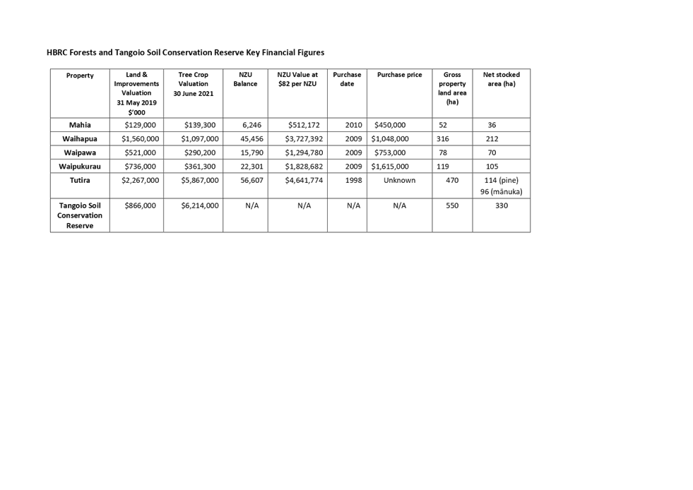
|
Venue:
|
Council
Chamber
Hawke's
Bay Regional Council
159
Dalton Street
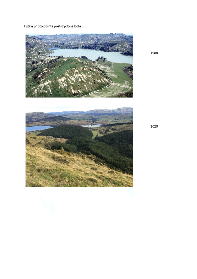
NAPIER
|
Agenda
Item Title Page
1. Welcome/Karakia/
Notices/Apologies
2. Conflict
of Interest declarations
3. Confirmation of Minutes of
the Environment and Integrated Catchments Committee meeting held on 9 March
2022
4. Follow-ups
from previous meetings 3
5. Call
for minor items not on the Agenda 7
6. Guardians
of the Ruakituri River presentation
7. Mahia
predator control presentation
8. Marae
riparian protection works presentation
Information
or Performance Monitoring
9. Integrated
Catchment Management response to recent flood events in Wairoa 9
10. Update
on IRG Flood Control Resilience funded projects 13
11. River
Managers Special Interest Group business case 19
12. Air
Quality Compliance with National Environmental Standards for Particulate Matter 25
13. Coastal
Bird Survey results 31
14. HBRC
Forestry 35
15. Discussion
of minor items not on the Agenda 61
Hawke’s Bay Regional
Council
Environment
and Integrated Catchments Committee
11 May
2022
Subject: Follow-ups from previous
meetings
Reason for report
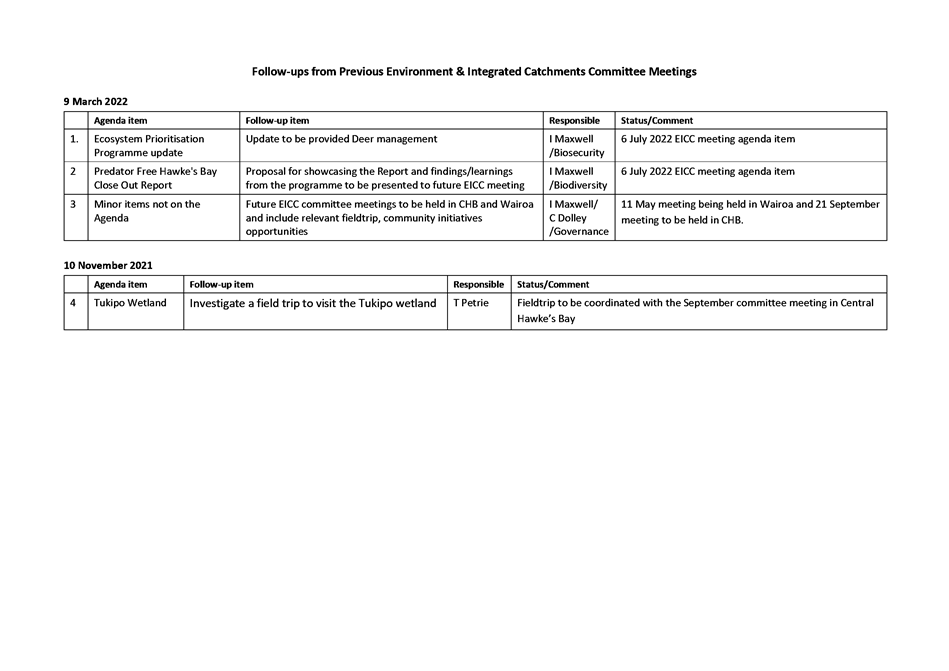
1. On the list attached are
items raised at previous Environment and Integrated Catchments Committee
meetings that staff have followed up on. All items indicate who is responsible
for follow up, and a brief status comment. Once the items have been reported to
the Committee they will be removed from the list.
Decision making process
2. Staff have assessed the requirements
of the Local Government Act 2002 in relation to this item and have concluded
that, as this report is for information only, the decision-making provisions do
not apply.
Recommendation
That the Environment and
Integrated Catchments Committee receives and notes the Follow-ups from
previous meetings.
Authored by:
|
Annelie Roets
Governance Advisor
|
|
Approved by:
|
Chris Dolley
Group Manager Asset Management
|
Iain Maxwell
Group Manager Integrated Catchment
Management
|
Attachment/s
|
1⇩
|
Follow-ups from previous meetings
|
|
|
|
Follow-ups from previous meetings
|
Attachment
1
|
Hawke’s
Bay Regional Council
Environment
and Integrated Catchments Committee
11 May
2022
Subject: Call for minor items not on
the Agenda
Reason
for Report
1. This item provides the
means for committee members to raise minor matters relating to the
general business of the meeting they wish to bring to the attention of the meeting.
2. Hawke’s Bay Regional
Council standing order 9.13
states:
2.1. “A meeting may discuss an
item that is not on the agenda only if it is a minor matter relating to the
general business of the meeting and the Chairperson explains at the beginning
of the public part of the meeting that the item will be discussed. However, the
meeting may not make a resolution, decision or recommendation about the item,
except to refer it to a subsequent meeting for further discussion.”
Recommendations
That the Environment and
Integrated Catchments Committee accepts the following Minor items not on the
Agenda for discussion as Item 15.
|
Leeanne
Hooper
Governance
Team Leader
|
James
Palmer
Chief
Executive
|
Hawke’s Bay Regional
Council
Environment
and Integrated Catchments Committee
11 May
2022
Subject: Integrated Catchment
Management response to recent flood events in Wairoa
Reason for Report
1. This item provides an
update on the activities being undertaken by the Integrated Catchment
Management team in response to the impacts of recent flooding in the Wairoa
area.
Background
2. The Wairoa region and north
along the East Coast experienced two significant and prolonged rain events,
22-24 March and 28-29 March 2022. The events were noticeable for the very
high rainfall and extended period.
3. The events caused
significant damage on farms and will require an ongoing and sustained programme
of action to support the community to farm through this.
4. HBRC has been active in
supporting the community in many ways from the onset of the events and will
continue to be active in the years to come.
5. Staff have provided a
summary of the actions to date in the paper and will talk to this. They
will also show photographs of the affected areas.
Discussion
6. Following is an overview of
the ICM Team’s activities to support landowners.
Catchment
Delivery
7. Phone calling landowners. Our team will be supporting
Federated Farmers (contracted by Wairoa District Council, Gisborne District
Council using the first tranche of MPI’s recovery fund) to make contact
with flood affected landowners asking specific questions to better understand
the extend of the damage to their properties. This is expected to take a
couple of weeks. The information collected will provide an opportunity to seek
further targeted recovery funding from MPI.
8. Woolshed workshops: Our staff are identifying
suitable content and speakers in preparation for an inter-agency approach to
support flood-affected farmers to get through. For example:
8.1. Soils specialist – To
present on soil health and options for farmers to undertake soil tests to
understand current soil health status (understanding that the impact of severe
weather event can take a lot of soil fertility away).
8.2. Pastures –
Undertaking feed budgeting, understanding current feed availability and feed
demand between now and spring.
8.3. Farming Systems – Is
there an option to develop a short term/interim farm system change to assist
recovery? With loss of pasture, pressure on pregnant ewes/cows, what options
are available to farmers to manage their system over winter with changes to
feed supply? What options are available for hill country farming for
supplementary feed, accessing feed, different feed types?
8.4. Infrastructure –
Temporary fence construction to help with subdivision or paddock restoration.
8.5. Business/Financial –
An accountant to speak to the group about tax or business options.
8.6. Animal Health & Welfare
– The local Vet to speak about an animal health plan for the short
term, understanding impacts of changed options for feeding and managing stock
(vaccinating ewes etc.)
8.7. Recovery – What are
the future requirements? HBRC talking about HCE and RTRP – starting the
conversation with farmers/landowners about a longer-term recovery plan that
considers options to future proof the next extreme weather event (drought,
flood, earthquake etc.) especially for pregnant ewes prior to lambing.
8.8. Erosion Control Scheme
– Currently,
staff are working with landowners affected by storm damage to find out what
their erosion control planting needs are this winter. We will ensure that
storm-affected areas are prioritised for pole planting. We understand that
other storm recovery work on farms will take priority over pole planting this
winter, so planting programmes will be developed on affected properties in the
future. Over 7,000 A grade poles for the Wairoa area will be made available.
These will be ready from early June.
8.9. Connecting Rural Wairoa
–
The Wairoa Community Development Trust coordinated the ‘Connecting Rural
Wairoa’ initiative, which supplied over 400 households with packages of
kindness, that included information and resources
to help individuals to manage and thrive through adversity. Our Wairoa
Catchment Delivery team volunteered time and vehicles to support the delivery
of these care parcels on Wednesday, 27 April.
Catchment
Policy Implementation
9. Supporting Catchment Groups
–
Supporting Guardians of the Ruakituri in applying for MPI Integrated Farm
Planning Accelerator funding to support production of high-resolution
individual farm FEPs and a catchment plan. Working with Catchment
Delivery staff on potential for new catchment group startups and potential to
access MPI Extension Services funding for Wairoa catchment groups.
Environmental
Science
10. Data for tomorrow - Our Environmental Science
and GIS teams are working with Wairoa District Council, Gisborne District
Council, GNS and Manaaki Whenua Landcare Research (MWLR) to collect high
quality imagery to assess the impact of the two weather events.
Initially, they aim to task the Pleiades satellite to collect aerial imagery of
the effected areas (approx. 4000 sq km) at a 0.5m resolution, and following
this up with orthophotography during the spring regrassing of the landslide
deposits. HBRC science team will be working with MWLR through an existing
partnership project, and additional works, to identify the scale and number of
landslides occurring from the two weather events, assessing connectivity
between the landslides and streams/waterways and updating our landslide
susceptibility modelling. This work will also make use of the recently
acquired LiDAR imagery and will inform our erosion control schemes.
11. HBRC Science has been in
discussion with Te Puni Kokiri and Ministry of Primary Industries to help
support this data acquisition for a range of end-user needs and has confirmed
purchase under a Whole of Government license.
Next Steps
12. Staff are working closely
with the Wairoa District Council which is the lead agency for recovery from the
event. We will continue to support the coordinated recovery and will be
active in the months and years to come after the formal recovery has concluded.
Decision Making Process
13. Staff have assessed the
requirements of the Local Government Act 2002 in relation to this item and have
concluded that, as this report is for information only, the decision making
provisions do not apply.
Recommendation
That the Environment and Integrated Catchments
Committee receives and notes the Integrated Catchment Management response to
recent flood events in Wairoa staff report.
Authored by:
|
Xan Harding
Senior Catchment Advisor (Policy Implementation)
|
Warwick Hesketh
Catchment Team Leader
|
|
Jolene Townshend
Acting Manager Catchment Delivery
|
|
Approved by:
|
Iain Maxwell
Group Manager Integrated Catchment
Management
|
|
Attachment/s
There are no attachments for this report.
Hawke’s
Bay Regional Council
Environment
and Integrated Catchments Committee
11 May
2022
Subject: Update
on IRG Flood Control Resilience Funded Projects
Reason for Report
1. This report provides an
update on the four projects approved for funding as part of the Crown’s
Flood Control Resilience Funding with the Infrastructure Reference Group (IRG)
managed by Kānoa – Regional Economic Development & Investment
Unit, formerly known as the Provincial Development Unit.
Background
2. Council has received IRG
funding for a total amount of up to $19.2m (plus GST, if any) which is a 64%
contribution to four projects.
3. Works commenced
on all four projects in late November 2020.
Discussion
Project 1: Heretaunga Plains Flood Control Scheme (HPFCS)
Levels of Service - $20m
4. The HPFCS Levels of Service
project will review and upgrade sites across the Tūtaekurī,
Ngaruroro, Lower Tukituki and Clive rivers as part of the Heretaunga Plains Flood
Control Scheme level of service review, to increase flood protection across the
scheme to a 1 in 500-year event.
5. HBRC co-funding of $7.2
million is required to match IRG funds of $12.8 million.
6. Physical works at Taradale
stopbank are underway. Cycle trail detours are in place to enable works
including tree removal and specimen tree relocation. Targeted completion for
stop bank strengthening was May 2022. There have been recurring weather events
now pushing completion of Taradale stop bank upgrade into winter (June 2022).
7. Investigations are complete
for Ngatarawa, Roy’s Hill, Moteo and East Clive. Ngatarawa detailed
design is complete and will be ready by May 2022 for construction procurement.
Latest work done by engineers show that Roy’s Hill will not require an
upgrade to withstand a 1 in 500 year flood event.
8. Based on investigations
done so far, the following sites have been selected for upgrade as a part of
this project.
|
Site Name & Location
|
River
|
Works Completed to Date
|
Proposed Works**
|
|
Taradale Stopbank Strengthening (XS 17 - 22 LHS)
|
Tūtaekurī
|
Archaeology assessment, geophysical testing, Geotechnical
investigation, Topographical survey, Preliminary Design, detailed design, 50%
Construction
|
Increase height of stopbank for overtopping, increased
width of stopbank, reduced slope on river-side
|
|
Moteo Stopbank Strengthening (XS 43b - 47 RHS)
|
Tūtaekurī
|
Archaeology assessment, geophysical testing,
Geotechnical investigation scoping, Topographical survey, field
investigations, concept design
|
Increase height at places – TBC following
optioneering
|
|
Omaranui (XS 23-41 RHS)
|
Tūtaekurī
|
Archaeology assessment, Topographical survey, 80%
design procurement
|
Increase height of stopbank for overtopping, build new
stop bank between XS 28 and XS 32.
|
|
Haumoana Stopbank Strengthening (XS 1 - 4 RHS)
|
Lower Tukituki
|
Archaeology assessment, Geotechnical investigation
scoping, Topographical survey
|
Increase height of stopbank for overtopping
|
|
East Clive Stopbank Strengthening (XS 1 - 4 LHS)
|
Lower Tukituki
|
Archaeology assessment, Geotechnical investigation
scoping, Topographical survey, field investigations, concept design
|
Increase height at places – TBC following
optioneering
|
|
Ngatarawa (XS 49 - 51 RHS)
|
Ngaruroro
|
Archaeology assessment, Geotechnical investigation
underway, Topographical survey, field investigations, concept design,
detailed design
|
Height of stop bank to be increased at places and
slopes to be reduced on both sides
|
|
Haumoana Upstream of Blackbridge (XS 4 - 10 RHS)
|
Lower Tukituki
|
Archaeology assessment, Topographical survey
|
Increase height of stopbank for overtopping
|
|
Farndon Road Erosion
|
Clive
|
Works scoped for Engineering Panel
|
Scour protection to Farndon Road
|
** Subject to outputs from site investigations,
geotechnical modelling and any additional hydraulic modelling
9. Procurement for significant
native planting programme to support environmental outcomes at Ngatarawa and
Roy’s Hill is complete. Further, landscape design is being developed in
partnership with Waiohiki marae to undertake Public Use of Rivers (PUR) works following
completion of Taradale stop bank upgrade.
10. HBRC has committed to
deliver eight stop bank strengthening projects over the three-year period
through IRG funded works. Further, by undertaking integrity investigations of
similar or higher priority sites in tandem, HBRC provides confidence in the
resilience of our flood protection assets and thus achieve the objective of
increasing climate resilience of HPFCS systematically. Should these
investigations lead to physical work requirement, this will add to the
following list.
|
Year
|
Committed Projects
|
|
1
|
Taradale Stopbank (earthworks, stop bank upgrade, PUR)
|
|
2
|
Moteo Stopbank (berm improvement – groynes or
strategic planting; earthwork requirement being assessed as part of design)
|
|
2
|
East Clive (stopbank upgrade required following
overtopping assessments; landfill on riverside presented additional
challenges)
|
|
2
|
Ngatarawa – Berm improvements (native tree
planting programme)
|
|
2/3
|
Clive River @ Farndon Road (erosion protection -
potentially sheet piling)
|
|
2/3
|
Omarunui (stopbank upgrade required &
archaeological complications being worked through)
|
|
3
|
Haumoana (stopbank upgrade required &
archaeological complications being worked through)
|
|
3
|
Haumoana upstream of Blackbridge (earthworks, stopbank
upgrade)
|
11. FY 20-21 expenditure was
$832k against a projection of $944k.
12. The estimated value of FY
2021-22, 2022-23 and 2023-24 planned works is $4.03 million, $9.52 million and
$5.61 million respectively. In 2021-22 this includes stopbank
strengthening construction works on Taradale, detailed design of three sites
(based on results from geotechnical investigations), commencement of
investigative work on further two sites. Omarunui and Farndon investigations
may push some works from year 2 to year 3.
13. FY 2022-23 planned works
includes stopbank strengthening construction works on at least further four
sites, detailed design of two sites (based on results from geotechnical
investigations) and completion of environmental enhancement of 5 sites.
14. FY 2023-24 planned works
includes stopbank strengthening construction works on at least further two
sites and completion of environmental enhancement of 3 sites.
Project 2: Upper Tukituki Gravel Extraction Flood Control
Scheme - $8 million
15. The purpose of the Upper
Tukituki (UTT) Gravel Extraction project is to seek opportunities to subsidise
extraction and transportation of gravel from this scheme with a focus on
competitive tendering and supporting the local economy. Gravel extraction
is required to maintain existing nameplate capacity of 1:100 level of
protection within this scheme. As a consultation topic in the 2020 Long Term
Plan, Council agreed to fund the HBRC co-contribution of $2.88m from the UTT
scheme through a long term loan allowing the project to proceed.
16. A Request for Tender (RfT)
was sent to 23 contractors, all of whom had pre-qualified through the
Registration of Interest (RoI). The tender included a volume of 116,700m3
gravel available for extraction, split between the Tukipo and Makaretu rivers.
17. HBRC received a total of
four tender submissions. Through the tender evaluation, two preferred
contractors were selected, with approximately half the available material being
awarded to each.
18. Tender acceptance letters
have been sent and contracts signed by both. Extraction has been started by
both.
19. It is planned for the next
tender round to be sent to market in May, with delay caused by flooding in
Central Hawke’s Bay in March, resulting in section surveys being required
to confirm availability.
20. A Chilean Needle Grass
survey was carried out from the confluence of the Waipawa and Mangaonuku Rivers
to approximately 3.3 km downstream. No Chilean Needle Grass was identified in
the survey area. The current restriction on gravel extraction has been eased,
allowing some extraction to occur in this area with restrictions on end use. A
formal notification has been received from the HBRC Biosecurity team.
21. To date, HBRC has
completed:
21.1. Gravel material testing
programme - results were made available to all tenderers as part of the ROI.
21.2. Prioritisation of key
reaches – based on the following criteria: freeboard (related to 100 year
flood risk), average annual flood risk (related to availability), and lateral
erosion risk. This allows extraction to focus on areas which are critical to
the flood protection of the UTT scheme.
21.3. Availability of gravel
– based on prioritisation, data provided as part of ROI to tenderers and
shall assist with programming. This data has also been shared with local
contractors, on request, following the last public meeting.
21.4. Identification of
additional access – HBRC Schemes team assisting with landowner
discussions for critical access.
21.5. Request for Information
from industry – 17 submissions received relating to cost for extraction
and transportation. This data will underpin the project’s rationale for
reasonable subsidised costs, specifically relating to transportation of
material.
21.6. Public meetings with both
ratepayers and contractors to provide updates on project status. Contractor
representation at public meetings were small- and medium-sized local businesses
as well as larger businesses from out of the region. HBRC staff have also met
on site with a small local contractor to better understand their business and
how they might support any potential Chilean Needle Grass (CNG) studies.
21.7. Assessment of known
archaeological assessment sites – working with New Zealand Archaeological
Association (NZAA) to map known sites on HBRC GIS with buffer zones based on
site type.
21.8. Liaison with HBRC Biosecurity
and AgResearch to scope a testing programme to manage CNG within the UTT
scheme. Works are likely to benefit from this programme and external funding is
being considered to achieve successful outcomes.
22. FY 2020-21 expenditure was
$298,000 and FY 2021-22 costs are estimated at $1.7 million.
23. In FY 2022-23 costs for
gravel extraction are estimated at $6.02 million.
Project 3: Upper Tukituki Flood Control Scheme SH50/Waipawa
Erosion - $1 million
24. Completed.
Project
4: Wairoa River, River Parade Erosion - $1 million
25. This one-year project was
to provide steel-sheet piled erosion protection and associated ecological and
biodiversity works on left bank of the Wairoa River.
26. The sheet piling works have
been completed and the focus has now shifted to landscaping and completion of
the site. Recent rain events have caused damage to the site that will require
cleanup prior to landscaping. Resources are currently deployed to urgent
projects within the region as a result of two rainfall events.
27. HBRC has been engaging with
local groups Tātau Tātau o Te Wairoa Trust, Wairoa Reserves Board
– Matangirau (WRB) and Wairoa District Council to identify the
aspirations and requirements of this project on the cultural values to the
region.
28. Option analysis of cultural
expression between Tatau Tatau, WRB, HBRC and WDC to be finalised.
29. FY 2020-21 expenditure was
$98k, and FY 2021-22 costs are estimated at $1,052M.
Social Procurement
30. Schedule 3 of the funding
agreement details Social Procurement Outcomes (SPOs) which are to be met as
part of the agreement. In order to meet our contractual obligations, HBRC has
proposed the following initiatives.
30.1. HBRC is collaborating with
respective maraes to plan public use of river works for every stretch of river
under the IRG upgrade work.
30.2. Engagement of contractors
who employ staff through Ministry of Social Development’s (MSD) mana in
mahi and Hastings District Council’s redeployment programme
30.3. Networking through MSD to
identify Māori/Pasifika businesses
30.4. Upskilling and training
contractors/consultants through a Tender Training workshop which includes
‘implementation of tender’ training. Session 1 was a pre-requisite
for subsequent drop-in sessions for one-on-one support with third party
provider. Session 2 has been conducted for half of the attendees and will be
conducted for the remaining attendees.
30.5. Partnering with Eastern
Institute of Technology – environmental science, biosecurity, film &
photography. Project study opportunities, project support, work experience,
planting assistance. HBRC have employed 2 film and 2 environmental science
students to work and learn as part of the HBRC Project Team.
30.6. Mates4Life suicide
awareness and prevention programme – linking up contractors/consultants
with mental health and wellbeing programmes.
30.7. Highlighting mental health
& wellbeing with our contractors in a drive to include this at toolbox
talks alongside health and safety. Incremental changes to the status quo.
30.8. Establishing partnership
agreements to dedicate project resources to upskill and train staff. This
includes contractors, consultants and client organisations whereby a continual
professional development style of record keeping is maintained in a simple,
manageable, cost effective way. This has been successfully implemented in the
Taradale project.
Collective Outcomes – National
Progressive Procurement Toolkit
31. HBRC’s procurement
team have recently developed a progressive procurement toolkit in collaboration
with Height Project Management. It is modelled on the Sustainable Outcomes
Toolkit (May 2019) developed by Auckland Council Healthy Waters and Height
Project Management which covers the following key areas, often referred to as
the ‘four pillars’.
31.1. Environmental – preventing and
reversing environmental degradation.
31.2. Economic - building a diverse and
prosperous local economy.
31.3. Social – shared and equal
opportunity for community prosperity.
31.4. Cultural – finding
opportunities to genuinely partner with mana whenua.
32. The IRG programme and
associated social outcomes have been discussed at a national level amongst the
River Managers Special Interest Group (SIG). Each of the regional councils are
responsible for meeting their respective SPO’s and have agreed that as a
collective group there are benefits to collaborating to provide a number of
national SPO’s. HBRC’s progressive procurement toolkit has been
socialised with other regional councils with the intent of implementing a shift
change in procurement to not only include SPO’s but the other three
pillars (Environmental, Economic and Cultural).
Decision Making Process
33. Staff have assessed the
requirements of the Local Government Act 2002 in relation to this item and have
concluded that, as this report is for information only, the decision making
provisions do not apply.
Recommendation
That
the
Environment and Integrated Catchments Committee receives and notes the “Update
on IRG Flood Control Resilience Funded Projects”.
Authored
by:
|
Tim Jones
Project Engineer
|
Harry Donnelly
Project Engineer
|
|
Priya Karanjai
Project Engineer
|
Martina Groves
Manager Regional Assets
|
Approved by:
|
Chris Dolley
Group Manager Asset Management
|
|
Attachment/s There are no attachments
for this report.
Hawke’s
Bay Regional Council
Environment
and Integrated Catchments Committee
11 May
2022
Subject: River Managers Special
Interest Group business case
Reason for report
1. This item updates the
Committe on work being undertaken by the regional council sector to obtain
ongoing central government co-investment in flood protection and river
management schemes, and presents a supplementary report prepared by the sector
for central government on permanent co-investment in New Zealand’s flood
protection schemes.
Executive Summary
2. A Regional Council business
case seeking a central government co-investment contribution of $150 million
per annum to enhance the integrity of flood protection schemes was presented to
central government officials in 2019. The three-year programme of COVID-19
relief funding (the sector’s Resilient River Communities programme or
‘shovel-ready’ projects co-funded by Kanoa) has been a major
contribution to Regional Councils’ efforts to respond to the challenges
that climate change presents. However, the business case has not yet achieved
the ongoing central government commitment to co-investment it was intended to
achieve. Hence the preparation of a supplementary report. The purpose of that
report is to update a 2019 comprehensive business case on the same topic.
3. The report draws on case
examples from 2021 with a focus on the 31 May 2021 Ashburton/Canterbury
flooding but also drawing on information from the July 2021 Westport and Marlborough
events. The report notes that while infrastructure remains of critical
importance, avoiding risk through appropriate land-use planning is vitally
important. In addition, the report reflects regional council progress toward
achieving the flood protection schemes of the future. Compared to those of the
past, these must satisfy a wider spectrum of community, environmental,
cultural, climate change, economic objectives, and contemporary iwi / Te Mana o
te Wai partnerships.
4. The sector has continued to
work together on the co-investment case. The regional sector is now sharing
that to stimulate conversation. The sector collaboration is to seek a budget
line item for $150 million of co-investment from the Climate Emergency Response
Fund, as proposed in the report.
Background
5. A Regional Council business
case seeking a central government co-investment contribution of $150 million
per annum to enhance the integrity of flood protection schemes was presented to
central government officials in 2019. The three-year programme of COVID-19
relief funding (the sector’s Resilient River Communities programme or
‘shovel-ready’ projects co-funded by Kanoa) has been a major
contribution to Regional Councils’ efforts to respond to the challenges
that climate change presents[1].
However, the business case has not yet achieved the ongoing central government
commitment to co-investment it was intended to achieve. Hence the preparation
of a supplementary report [2](attached).
6. Following the significant
flood events of 2021, Environment Canterbury led the creation of a
supplementary co-investment report for central government. The purpose of that
report is to update a 2019 comprehensive business case on the same topic. This
is timely, given damaging floods (West Coast, Gisborne, Auckland in 2022), and
is highly relevant to Otago given the repeat floods in 2019-2020.
7. The report draws on case
examples from 2021, with a focus on the 31 May 2021 Ashburton/Canterbury
flooding but also drawing on information from the July 2021 Westport and
Marlborough events. The report describes these flood events, flood protection
scheme locations and performance assessments, community responses, details
about the on-going impacts of the flood events and scheme value propositions.
Most importantly, the report also provides event-specific details about the
many millions of dollars of valuable Crown assets protected from 2021 floods by
flood protection schemes. The protection of these assets is just one of the
many reasons for central government to invest in flood protection schemes.
8. The report notes that while
infrastructure remains of critical importance, avoiding risk through
appropriate land-use planning is vitally important. This includes hazard
assessment and communication, mapping and zoning, locating new development in
low-risk areas, restrictive planning in high-risk areas and managed retreat.
9. In addition, the report
reflects regional council progress toward achieving the flood protection
schemes of the future. Compared to those of the past, these must satisfy a
wider spectrum of community, environmental, cultural, climate change, economic
objectives, and contemporary iwi / Te Mana o te Wai partnerships.
10. The sector has continued to
work together on the co-investment case. The regional sector is now sharing
that to stimulate conversation. The sector collaboration is to seek a budget
line item for $150 million of co-investment from the Climate Emergency Response
Fund, as proposed in the report.
Discussion
11. Floods are New
Zealand’s most frequent and, cumulatively, most significant and avoidable
hazard. They are the natural hazard most able to be mitigated through
application of a well-proven package of flood protection schemes. They are also
the natural hazard with the best return on investment from measures
contributing to active risk reduction.
12. Climate change will
substantially increase the risk of severe and frequent flooding in New Zealand.
Climate change projections [3]
for Hawke’s Bay are that mean annual rainfall totals are expected
to decrease across the region, and the intensity of extreme, rare rainfall
events are likely to increase. Changes in mean annual flood of up to a 50%
increase are expected by the end of the century for most of Hawke’s Bay Rivers.
13. Flood protection schemes
are a critical first action in adapting to the impacts of climate change.
Without ongoing investment in these schemes, we will not address climate change
and community resilience.
14. The challenge is to ensure
the existing schemes are managed and enhanced in a way that enables them to
continue to play a vital part in New Zealand’s approach to building
climate resilience. Seeking co-investment from central government as part of a
nationwide solution to a national problem is a key part of this response. The
recent Ashburton, Westport, and Marlborough floods have provided further
evidence of the need for central government investment and the supplementary
report documents that evidence as an update to an earlier report [4](attached).
15. In
Hawke’s Bay, Hawke’s Bay Regional Council provides flood protection
and land drainage to approximately 70,000 ha of rural and urban land. This
is achieved through managing infrastructural assets that include 249km of
stopbanks, 19 pump stations, 650 structures (bridges, culverts, flood gates)
and various other assets, across the region’s rivers and a total of 25
flood protection and/or drainage schemes.
16. Capital
investment set out in the 2021-31 Long Term Plan (years 1 through to 10) of
$M18.2. The Infrastructure Strategy 2021-2051. provides an estimate of $M88.6
over the 30- year period which includes high level estimation of major renewals
and replacement. The LTP does not include flood events, other natural hazard
events, betterment and/or response to climate change adaptation.
17. Significant issues will
face the flood protection, river assets and drainage activities for the
Hawke’s Bay Regional Council over the next 30 years. The LTP committed to
undertaking infrastructure planning for all schemes. The issues being
investigated by this infrastructure or scheme planning are presented
diagrammatically in Figure 1. All significant issues are inextricably
linked to one another, with ‘Funding’ being a key issue. The
Infrastructure Strategy sets out a long planning horizon which recognises that
addressing some of the significant issues will require long lead times that
will inform decision-making, cost implications and affordability.
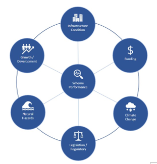
Figure 1 Significant issues and associated links for
flood protection and drainage
18. These issues are relevant
across all regional councils, as we collectively approach the future thinking
on affordability to appropriately address significant issues facing flood
protection across New Zealand.
19. Recent events across Canterbury
and West Coast demonstrate the vulnerability of flood protection schemes,
severity of flood events and the damage caused. The affordability of repairs
and recovery faced by Regional Councils while balancing business as usual
programmes of work, prevails as a continued challenge to all Councils including
ORC. For example, between November 2019 and February 2020 two heavy rainfall
events affected the Otago region, particularly the Clutha River catchment,
which caused damage and subsequent repairs required to schemes and rivers. The
flood recovery programme is almost complete. There were 36 flood damaged sites,
of which 29 had been completed as of 31 December 2021.
20. Government co-investment
has occurred with government initiative to provide economic stimulus funding
for ‘shovel Ready’ projects following the COVID-19 event, initially
referred to as Crown Infrastructure Partners (CIP) Shovel Ready Funding. Four
HBRC projects, specifically related to flood protection, were successful in
receiving central government (Kanoa) co-funding of approximately $19.2m out a
total project value of $30m. These are being delivered as part of the
sector’s Resilient River Communities programme11 comprising 55
projects with a total value in excess of $300M.
21. More communities and
expanded public assets (with much a higher value than when the schemes were
originally constructed) are now at risk from floods. This is evident with urban
growth and intensification of agricultural practices.
22. Schemes also are now required
to achieve integrated land uses, enhance ecological and water quality outcomes
and meet contemporary iwi and wider community aspirations. Increased levels of
investment are now required with the increased pressure with climate
resilience, community resilience and scheme performance to meet the demands of
the environmental and climate challenges we face.
23. This can only be achieved
with the support of the Government returning to the flood protection investment
table. Without continued co-investment, communities and the HBRC will face even
longer lead times in implementing programmes to mitigate the significant issues
including responding to on-going flood events and recovery/repair from flood
events.
Considerations
Financial Considerations
24. These are described in the
report.
Significance and
Engagement Considerations
25. No considerations arising
from this item.
Legislative and Risk
Considerations
26. No considerations arising
from this item.
Climate Change
Considerations
27. The release of the
supplementary report is proactive and seeks further investment now, considering
the effects of climate change which will bring more frequent and more intense
flood events.
28. Climate resilience is
currently being enhanced by the accelerated delivery of flood protection
projects under the current climate resilience programme of work to support
Covid-19 recovery. This one-off central government investment, combined with
co-funding from HBRC, has brought forward $30 million of infrastructure
projects providing community resilience earlier than would have otherwise been
affordable for ratepayers.
Communications
Considerations
29. The release of the
supplementary report is being communicated through the regional council sector.
30. The HBRC communications team
are involved with the regional council sector through the climate resilience
programme.
Next Steps
31. The sector will continue to
work together to seek a budget line item for $150 million of co-investment from
the Climate Emergency Response Fund, as proposed in the report.
32. Letters have been sent by
sector representatives to key Government Ministers and meetings are being
arranged. A media campaign and ongoing engagement with partners and
stakeholders, led by the sector, will commence.
Decision Making Process
33. Staff have assessed the
requirements of the Local Government Act 2002 in relation to this item and have
concluded that, as this report is for information only, the decision-making
provisions do not apply.
Recommendation
That
the
Environment and Integrated Catchments Committee receives and notes the River Managers Special
Interest Group Business Case staff report and also notes the Regional Council Sector
work seeking to obtain ongoing central government co-investment in flood protection
and river management schemes.
Authored & approved by:
|
Chris Dolley
Group Manager Asset Management
|
|
Attachment/s
|
1
|
Central Government Co-Investment in
Flood Protection January 2022 Supplementary report
|
|
Under Separate Cover
|
|
2
|
Tonkin and Taylor Report - Hiding in
Plain Sight April 2018
|
|
Under Separate Cover
|
Hawke’s
Bay Regional Council
Environment
and Integrated Catchments Committee
11 May
2022
Subject: Air Quality Compliance with
National Environmental Standards for Particulate Matter
Reason for Report
1. This item presents Dr Emily
Wilton’s assessment of the likelihood the region’s urban airsheds
and rural towns will consistently meet the existing particulate matter (PM10)
standard and comply with the proposed new standards for PM2.5.
This item also outlines the implications for the region’s air quality
objectives of the updated World Health Organisation (WHO) air quality
guidelines.
2. In 2020, the Ministry for
the Environment (MfE) publicly consulted on a proposal to include a daily PM2.5
standard of 25 µg/m3 (micrograms per cubic metre) and an
annual standard of 10 µg/m3 in the National Environmental
Standards for air quality (NESAQ). The proposed daily standard would
allow for three exceedances of the threshold in a 12-month period.
3. Additionally in 2020, the
existing standard for PM10 reached a milestone that meant all the
region’s airsheds are now limited to no more than one exceedance per year
of the daily threshold of 50 µg/m3.
Executive Summary
4. In 2020, MfE proposed
adding a daily and annual PM2.5 standard to the NESAQ and using
these, rather than PM10, as the main regulatory tool for
particulates. The review of the NESAQ does not have a clear timeline for
completion and, in the meantime, the existing standard of PM10 has
passed the date by which all airsheds are limited to just one exceedance of the
threshold in a 12-month period. Dr Emily Wilton from Environet Limited
assessed the ability of the region’s urban and rural centres to meet the
current PM10 standard and the proposed PM2.5 standards.
5. The Napier Airshed is
expected to consistently meet the existing PM10 standard without the
need for further regulation, though the margin of safety is relatively
small. The Napier Airshed is also expected to meet the proposed annual PM2.5
standard. An estimated reduction of 20% in winter daily PM2.5
is required to comply with the proposed daily PM2.5 standard, which
is unlikely to be achieved by 2030 without additional management measures.
6. The Hastings airshed may
need further reductions in PM10 to consistently meet the daily
standard but these may occur in the absence of additional regulation and
potentially by 2025. However, implementing further measures to reduce emissions
would provide greater confidence. The Hastings airshed is expected to
meet the proposed annual PM2.5 standard but not the daily standard,
requiring an estimated 33% reduction in winter daily PM2.5. An
example of additional measures that could apply in both Napier and Hasting is
setting ultra-low emission burner (ULEB) criteria for new and replacement
burner installations, accompanied by educational campaigns promoting clean
forms of heating and good practice when using burners, such as ensuring the
wood is dry.
7. Dr Wilton undertook
emission inventories for Wairoa, Waipawa and Waipukurau. Separate
airsheds have not previously been gazetted for the three towns because
particulate concentrations were considered unlikely to exceed the NESAQ PM10
standard. The inventories identified domestic heating as the main
contributor to daily winter particulate levels in each town, though Wairoa also
has a significant contribution from industry. Reductions in particulate
concentrations are expected to occur over time through natural attrition of old
burners that are currently not NESAQ compliant. It is uncertain whether natural
attrition will be sufficient to achieve the proposed NESAQ PM2.5
standards.
8. Dr Wilton’s
assessment did not extend to the Awatoto airshed but the move to using PM2.5
as the main regulatory tool is expected to benefit the Awatoto airshed, where
natural sources dominate PM10. PM2.5 has a smaller
component of natural sources and is likely to be dominated by particulates from
combustion. The NESAQ for PM10 has been breached in the last
two years but the airshed would comply with the proposed daily and annual PM2.5
standards.
9. The WHO updated its air
quality guidelines in September 2021. The most significant changes were a
reduction in the daily PM2.5 guideline from 25 µg/m3
to 15 µg/m3 and the annual guideline from
10 µg/m3 to 5 µg/m3.
Additionally, the daily PM10 guideline changed from
50 µg/m3 to 45 µg/m3 and the annual
guideline from 20 µg/m3 to 15 µg/m3.
The WHO annual limit for nitrogen dioxide (NO2) was reduced from
40 µg/m3 to 10 µg/m3 and a daily
limit set at 25 µg/m3. The daily PM10,
PM2.5 and NO2 guidelines allow for 3-4 exceedances per
year.
10. The WHO threshold limits
for PM2.5 are significantly lower than those currently proposed by
MfE. A final decision has not been made on the proposed NESAQ amendments.
If instead MfE adopts the new WHO guidelines or the Council recommits to a
strategic goal of meeting the WHO guidelines by 2025, then additional
regulatory measures will be required to achieve them. The annual PM2.5
guideline will be especially challenging, considering that average PM2.5
in seasons outside winter can exceed 5 µg/m3. The
Awatoto airshed, which has less seasonal variation in PM2.5, would
also need a reduction in levels to achieve the annual guideline.
11. The WHO threshold for NO2
might also present a new challenge for urban air quality. Numerous exceedances of the daily limit were observed
during roadside monitoring of NO2 in Napier and Hastings during
winter last year. It is also possible the annual limit is not being
met. Transport is the main source of NO2 in our urban
centres and it is not a source that is currently regulated in our Air Plan.
Strategic Fit
12. Both the Strategic Plan and
the Regional Resource Management Plan contain targets for regional air
quality. Changes to the NESAQ and WHO air quality guidelines have
implications for the stated targets and the region’s ability to meet
them.
13. The Strategic Plan 2020-25
lists as a goal - “By 2025, regional air quality consistently meets World
Health Organisation guidelines”. This goal was introduced prior to
the 2021 update to the WHO guidelines. A decision to recommit to this
goal in future strategic plans means aiming for stricter guidelines than
existed when the plan was adopted. They are also stricter than thresholds
currently in the NESAQ or being proposed for the NESAQ.
14. Objective 39 of the
Regional Resource Management Plan is - “A standard of ambient air quality
is maintained at, or enhanced to, a level that is not detrimental to human
health, amenity values or the life supporting capacity of air, and meets
National Environmental Standards”. Therefore, it is appropriate to
determine whether the region is or could meet proposed changes to the NESAQ,
with or without additional interventions. Dr Wilton’s work
addresses that question.
Background
15. MfE announced in 2019 that
it was reviewing the NESAQ. The proposed amendments, released for public
consultation in 2020, signalled the introduction of daily and annual PM2.5
standards to replace PM10 as the main regulatory tool for managing
particulate matter. MfE aligned the proposed new PM2.5
standards with the WHO guidelines, which at the time were an annual threshold
of 10 µg/m3 and a daily threshold of 25 µg/m3,
with three permissible exceedances of the latter in a 12-month period.
16. The existing NESAQ gave
polluted airsheds, which included the Hastings airshed, until 1 September
2020 to achieve the PM10 threshold with no more than one exceedance
per year. With the passing of that milestone, the limit now applies to
all the region’s airsheds.
17. The WHO, in 2021, updated
its air quality guidelines based on new evidence on the health impacts of air
pollution. The updated guidelines included significant changes to
thresholds for particulates and NO2. The new daily and annual
PM2.5 guidelines are 15 µg/m3 and
5 µg/m3 respectively. The daily and annual PM10
guidelines are 45 µg/m3 and 15 µg/m3
respectively. The annual NO2 guideline is 10 µg/m3
and the daily NO2 guideline is 25 µg/m3.
The daily guidelines permit 3-4 exceedances in a 12-month period.
18. Particulate concentrations
in Napier and Hastings have reduced since continuous monitoring began in
2005. The reductions have been achieved through a combination of rules
and non-regulatory initiatives like the Heatsmart scheme. The Air Plan introduced
rules phasing out the use of old burners for domestic heating. The
Heatsmart scheme offered residents financial assistance to change to cleaner
forms of heating and install insulation. The measures were introduced to
safeguard the health of residents and to comply with the NESAQ. The
Napier and Hastings airsheds complied with the NESAQ last year. It is a
significant achievement considering PM10 concentrations in Hastings
once exceeded the PM10 standard 27 times within a winter season.
19. Health based changes to the
NESAQ and the WHO guidelines will potentially shift the goalposts for the
region’s air quality. Following the release of the consultation
document on proposed NESAQ amendments, Dr Wilton assessed whether the Napier
and Hastings airsheds are likely to meet proposed changes to the NESAQ. Her
scope extended to some of the region’s larger towns – Wairoa,
Waipukurau and Waipawa. However, the proposed amendments have not been
finalised.
20. MfE signalled in March that
it is awaiting the updated Health and Air Pollution in New Zealand (HAPiNZ)
report before progressing the NESAQ review, which will add to the evidence
informing the particulate matter proposals. MfE is also undertaking work
to determine how NESAQ will be incorporated into the planned new resource
management system. It is possible stricter thresholds may ultimately
apply to the region’s air quality either through the NESAQ or by the
Council choosing to recommit to the WHO guidelines, now that they have been
revised.
Assessment Results –
Napier Airshed
21. The Napier Airshed has had
one or fewer exceedances of the NESAQ for PM10 in the last eight
years and is expected to comply with the standard in the future. The
margin of success is currently small and subject to meteorological
conditions. However, further reductions in emissions should occur through
natural attrition of older wood burners and gradual uptake of ultra-low emission burners
(ULEBs) or other forms of heating. The annual guideline of
20 µg/m3 has been consistently met in the Napier Airshed
since continuous monitoring began in 2005.
22. An estimated 20% reduction
in daily winter PM2.5 is required in the Napier Airshed to achieve
compliance with the proposed daily standard of 25 µg/m3.
The estimated reduction accounts for three permitted exceedances in a 12-month
period. A 20% reduction is unlikely to occur by 2030 through the natural
attrition of older burners but compliance might be achieved if the installation
of new or replacement burners is limited to those meeting ULEB criteria.
The proposed annual standard for PM2.5 of 10 µg/m3
has been met in the last two years and that is likely to continue.
Assessment Results – Hastings Airshed
23. The Hastings Airshed has
had one or fewer exceedances of the NESAQ for PM10 in 2020 and 2021
but ongoing success is uncertain and dependent on meteorological
conditions. Dr Wilton noted that some non-compliant burners and fires
appear to still be operating in the airshed. This came to light when she
completed an air emission inventory for Napier, Hastings and Havelock North in
2020, which included a telephone survey asking residents about the main way
they heat their homes. Full compliance with the rules of the Air Plan and
limiting new or replacement burners to those meeting ULEB criteria would
increase the likelihood of success. The annual PM10 guideline
has been met in the last five years and that should continue.
24. An estimated 33% reduction
in daily winter PM2.5 is required in the Hastings Airshed to achieve
compliance with the proposed daily standard. This is unlikely to be
achieved by 2030 through restricting the installation of burners to ULEBs
because the attrition of burners currently in use is not expected to be at a
rate that would achieve the required level of reduction. However, it
might be achieved if that restriction is accompanied by an education campaign
that reduced emissions by another 10%. For example, the campaign could
highlight good practice when operating a burner, particularly the use of dry
wood, and promote the uptake of clean forms of heating. Annual average PM2.5
is currently within the proposed annual standard.
Assessment Results – Wairoa, Waipukurau and Waipawa
25. Emission inventories were
undertaken by Dr Wilton for Wairoa, Waipukurau and Waipawa. These showed
that domestic heating accounts for most of the towns’ daily winter PM10
and PM2.5. Wairoa also has a significant contribution from
industry, mostly related to the operation of boilers.
26. Dr Wilton
estimated reductions in particulates that might occur in the towns by 2030
under two scenarios – the absence of regulations and restricting burner
installations to ULEBs. In the absence of regulations, a reduction of 20%
is possible in Wairoa and 30% in Waipukurau and Waipawa. Under the ULEB
requirement, the reductions increase to 25% and 40% respectively.
27. Low-cost PM10
monitoring in Wairoa and Waipukurau suggests the towns are either meeting the
PM10 standard or the projected reductions without regulation will
enable the standard to be met. However, monitoring using instruments that
comply with Schedule 2 of the NESAQ is required to confirm this.
28. Low-cost PM2.5
monitoring in Wairoa and Waipukurau suggests that Wairoa may need the ULEB
requirement to meet the proposed PM2.5 standard and possibly
accompanied with a behaviour change campaign. Waipukurau could possibly
meet the proposed standard by 2030 in the absence of regulation. As noted
above, monitoring that is compliant with Schedule 2 of the NESAQ is required to
confirm this.
Awatoto Airshed
29. The Awatoto airshed was not
included in Dr Wilton’s assessment. The existing PM10
standard has been breached in the last two years, with five exceedances in each
year. The contribution of natural sources, particularly in La Niña
conditions, is considerable and makes meeting the standard difficult. It is an
airshed that would benefit from the main regulatory measure being PM2.5
because the component of natural sources, such as sea spray, is typically much
smaller. The proposed daily and annual PM2.5 standards are
currently being met in Awatoto.
Updated WHO Guidelines
30. The changes to the WHO
guidelines for PM10, which reduce the daily limit to
45 µg/m3 (with three permitted exceedances) and the
annual limit to 15 µg/m3, should be achievable in Napier
without further regulation. They are also achievable in Hastings,
particularly if there is full compliance with the Air Plan and a ULEB
requirement for new and replacement burners is introduced. Wairoa,
Waipukurau and Waipawa should also achieve the guideline, but monitoring with
upgraded instruments is required to confirm this. The high level of PM10
contributed by natural sources in Awatoto makes the WHO guidelines very hard to
achieve in that airshed.
31. The changes to the WHO
guidelines for PM2.5, which reduce the daily limit to
15 µg/m3 (with three permitted exceedances) and the annual
limit to 5 µg/m3, will be very challenging to
achieve. Reductions in winter daily PM2.5 of more than 50%
would be needed in Hastings and Napier and similar reductions could also apply
to Wairoa, Waipukurau and Waipawa. Winter levels overall would need to be
on a par with summer levels and even summer concentrations can, on occasions,
be near or exceed 5 µg/m3. In Awatoto, the daily
limit is likely to be achieved but annual averages hover around
6 µg/m3.
32. While this report
concentrates on particulates, the updated NO2 guidelines may also
prove challenging to meet. Roadside monitoring of NO2 was
undertaken in Napier and Hastings during June and July 2021. Within the two
months, the daily limit was exceeded four times at the Hastings location and more
than twenty times at the Napier location. The
average daily NO2
concentration of 21 µg/m3 and 16 µg/m3
in Napier and Hastings respectively, raises concern that we might exceed the
annual guideline if NO2 is monitored year-round.
Discussion
33. The NESAQ is undergoing a
review to ensure it reflects current knowledge about the health impacts of
ambient PM10 and PM2.5. The timeline for completion
of the review is uncertain. The WHO air quality guidelines were updated
in 2021 to incorporate new evidence about the impacts of air pollution on human
health.
34. The proposed amendment of
the NESAQ will shift the focus of regulatory compliance from PM10 to
PM2.5. This means that the polluted status of an airshed and
associated restrictions on consented discharges would depend on PM2.5
concentrations. This move would benefit the Awatoto airshed, where the
large contribution of natural sources to PM10 makes the PM10
standard difficult to achieve. Napier and Hastings will likely need a
shift from current wood burners to ULEBs combined with practice change
campaigns to meet the proposed daily PM2.5 standard. This could
also apply to the region’s larger towns and they may also need to be
gazetted as airsheds.
35. If the NESAQ is amended in
line with the updated WHO guidelines or the Council chooses to adopt these as a
strategic goal, then achieving them would require reducing winter average PM2.5
concentrations to near summer levels. However, in Awatoto, summer levels
are already often above 5 µg/m3. NO2
levels would also come under the spotlight and as these relate mostly to
transport, reducing emissions would involve a different approach to those
employed to reduce particulates.
Next Steps
36. PM2.5 monitoring
with upgraded instruments is needed in Hawke’s Bay’s larger towns
to gain a better understanding of particulate levels. New instruments
measuring PM10 and PM2.5 are currently being co-located
with older instruments at the Napier and Hastings monitoring sites, with the
intention of replacing the old monitors with the new ones. Concentrations
between the old and new instruments will be compared over winter. It may
be found that transitioning to the new instruments will raise measured
concentrations because of a change in measuring technology rather than a change
in emissions. This could mean the magnitude of reductions required to achieve
new air quality targets may be greater than initially anticipated.
37. The extent to which
pollutant levels need to be reduced is dependent on a completed NESAQ review
and/or a Council decision on adopting the updated WHO guidelines as a strategic
goal and feedback from tangata whenua, key stakeholders, and the community
during Kotahi plan development.
Decision Making Process
38. Staff have assessed the
requirements of the Local Government Act 2002 in relation to this item and have
concluded that, as this report is for information only, the decision making
provisions do not apply.
Recommendation
That the Environment and Integrated Catchments
Committee receives and notes the Air Quality compliance with National
Environmental Standards for Particulates staff report.
Authored by:
|
Dr Kathleen Kozyniak
Principal Scientist (Air)
|
|
Approved by:
|
Anna Madarasz-Smith
Manager Science
|
Iain Maxwell
Group Manager Integrated Catchment
Management
|
Attachment/s
|
1
|
Air Quality Management in
Hawke’s Bay, 2021 update. Prepared by Emily Wilton, Environet Ltd
|
|
Under Separate Cover
|
Hawke’s
Bay Regional Council
Environment
and Integrated Catchments Committee
11 May
2022
Subject: Coastal Bird Survey Results
Reason for Report
1. This item provides a
summary of the results of a baseline survey of indigenous bird values along the
Hawke’s Bay coastline (the survey).
Executive Summary
2. Hawke’s Bay supports
a vast array of coastal bird species along our diverse coastline. As part of
our responsibilities for the sustainable management of natural resources, and
in line with our strategic goal of healthy, functioning and climate-resilient
biodiversity, a baseline survey of these bird species using areas of our coast
and estuaries was required to provide HBRC with population estimates and
detailed distribution maps for Hawke’s Bay’s coastal bird species.
3. A total of 321 km of the
Hawke’s Bay coastline (from south of Whangaehu beach to Mahanga) was
traversed either by foot or by boat, and the presence and number of all species
of birds and marine mammals encountered was recorded for each separate 1 km
section of coastline surveyed.
4. A total of 79 bird species
and two marine mammal species were detected during this survey. 57 bird species
(72%) are native or endemic to New Zealand, and 28 of these species (35%) are
ranked as either Nationally Threatened or At Risk under the New Zealand Threat
Classification System.
5. Local indigenous species
diversity was highest at estuaries, river mouths and coastal lagoons, on
inshore islands and along sections of coastline with mixed rocky shore and
sandy beach habitats.
6. Maungawhio Lagoon and the
eastern coast of Māhia Peninsula, Te Whanganui-a-Orotū/Ahuriri
Estuary and the Pōrangahau Estuary are nationally and regionally important
habitats for a range of Arctic-breeding and endemic shorebird species, including
kuaka/bar-tailed godwit, ruddy turnstone, pohowera/banded dotterel and ngutu
pare/wrybill.
7. Based on the findings of
the survey, changes
to the regional threat rankings of 12 of the 23 bird species are recommended;
four species have an improved status, six species have a worsening status, and
two species have a neutral status. Nine of these changes are a result from new
data collected during this survey.
Strategic Fit
8. The survey contributes to
our strategic goal of healthy, functioning and climate-resilient biodiversity
(HBRC Strategic Plan 2017-2021).
9. It includes critical
information to increase the effectiveness to implement existing and upcoming
statutory frameworks including:
9.1. Regional Coastal
Environment Plan
9.2. New Zealand Marine Oil
Spill Readiness and Response Strategy 2018-2022
9.3. National Policy Statement
for Indigenous Biodiversity.
10. This work also
contributes to Kotahi policy development for determining Significant
Conservation Areas.
11. The survey aligns with
programmes in Biosecurity, Biodiversity, Predator Free Hawke’s Bay,
Coastal/Marine Science, and Policy work streams. The dataset will inform
the Ecosystem Prioritisation Programme, Coastal and Marine ecosystem
prioritisation (in progress), and Outstanding Water Bodies.
Background
12. The
Hawke’s Bay coastline (ca 345 km) is an important breeding and foraging
ground for many indigenous birds. Many of these species are at risk of
extinction due to habitat loss and degradation, predation, and impacts from
other human activities. Climate change is likely to add compounded
challenges to these species.
13. HBRC has statutory
responsibilities relating to the sustainable management of the natural values
of the Hawke’s Bay coastline, including its indigenous bird values.
14. HBRC commissioned a
complete and systematic survey of the indigenous bird values of the
Hawke’s Bay coastline in January 2021, to create a regional-scale
baseline measure of the diversity, distribution and abundance of indigenous
birds inhabiting the Hawke’s Bay coastline.
Discussion
15. The survey:
15.1. Covered 321 km of the
region’s approximately 345km coastline by foot or boat
15.1.1. 24 km of the coast was not
surveyed (north of Kairakau to Waimarama and the eastern side of Mahia Peninsula)
due to lack of landowner approval or inaccessibility
15.2. Recorded 79 bird species
and two marine mammal species (NZ fur seals and common dolphins)
15.3. Recorded 32,660 individual
birds.
16. 28 of the bird species
detected (35%) are ranked as either Nationally Threatened or At Risk under the
New Zealand Threat Classification System, including:
16.1. 4 species ranked as
Nationally Critical
16.2. 1 species ranked as
Nationally Endangered
16.3. 4 species ranked as
Nationally Vulnerable
16.4. 8 species ranked as At
Risk, Declining
16.5. 2 species ranked as At
Risk, Relict
16.6. 4 species ranked as At
Risk, Recovering and
16.7. 5 species ranked as At
Risk, Naturally Uncommon.
17. 19 of the bird species
detected (24%) are ranked as Regionally Threatened under the New Zealand Threat
Classification System, including:
17.1. 12 species ranked as
Regionally Critical
17.2. 3 species ranked as
Regionally Endangered and
17.3. 4 species ranked as
Regionally Vulnerable.
18. The survey highlighted the
role that larger estuaries and river mouths play as areas of high species
richness. Stretches of the mainland coastline that possessed a heterogeneous
mix of habitats including a mix of sandy or shingle beaches and intertidal rock
platforms also supported a higher diversity of indigenous bird species,
including the eastern coastline of Māhia Peninsula, the coastline between
Tangoio and the Moeangiangi River, and the coastline between Pōrangahau
and Pourerere beaches.
19. Among the 65 estuaries and
coastal lagoons surveyed, Te Whanganui-a-Orotū/Ahuriri Estuary supported
the highest diversity of indigenous birds with 33 species and 3,356 individuals
counted. The Pōrangahau Estuary supported the second highest number of
indigenous bird species, with 24 species and 1,311 individuals counted, and the
Maungawhio Lagoon supported the third highest number of species, with 22
species and 420 individual birds counted.
20. Key findings of the survey
include that:
20.1. Hawke’s Bay supports
16% of the global population of pohowera / banded dotterel
20.2. Tūturiwhatu / New
Zealand dotterels have experienced a substantial increase in population size
and breeding range along the Hawke’s Bay coastline since 2011 due to a
successful species recovery plan
20.3. Hākoakoa / sooty
shearwaters were re-discovered to be breeding on Te Motu-o-Kura /Bare Island.
Next Steps
21. Changes to the regional
threat rankings of 12 of the 23 bird species are being recommended as a result
of new data collected during this survey, being:
21.1. four species have an
improved status
21.2. six species have a
worsening status
21.3. two species have a neutral
status.
Decision Making Process
22. Staff have assessed the
requirements of the Local Government Act 2002 in relation to this item and have
concluded that, as this report is for information only, the decision-making
provisions do not apply.
Recommendation
That
the
Environment and Integrated Catchments Committee receives and notes the Coastal
Bird Survey Results staff report.
Authored by:
|
Becky Shanahan
Senior Scientist Marine and Coasts
|
Anna Madarasz-Smith
Manager Science
|
Approved by:
|
Iain Maxwell
Group Manager Integrated Catchment
Management
|
|
Attachment/s
There are no attachments for this
report.
Hawke’s Bay Regional
Council
Environment
and Integrated Catchments Committee
11 May
2022
Subject: HBRC Forestry
Reason for Report
1. This paper provides a
summary of Hawke’s Bay Regional Council’s (HBRC) forestry assets,
including the Tūtira
mānuka plantation.
2. The information was presented
initially in two separate papers, one dealing with the mānuka plantation
and the other the remainder of the forestry asset, to FARS Committee 2 March
2022.
3. The two papers have been combined and
presented again here following decisions at that meeting.
Executive Summary
4. HBRC manages the 550ha
Crown-owned Tangoio Soil Conservation Reserve as required by section 16 of the
Soil Conservation and Rivers Control Act (1941). Fifty-eight percent (320ha) of
the Reserve is currently in commercial forestry and the remainder in native
forest at varying stages of regeneration. Commercial forest in the Reserve has
a 30 June 2021 valuation of $6,214,000 (attached).
5. In addition, there are
529ha of commercial forestry across five HBRC-owned properties of a combined
area of 1029ha. These properties have a range of objectives as described in
this item, including wastewater irrigation, carbon sequestration, recreation,
and trialling and demonstrating alternative timber species. Commercial forest
in the HBRC properties has a 30 June 2021 valuation of $7,754,800.
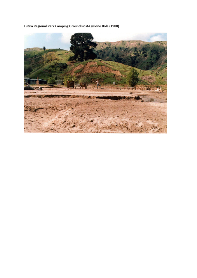
6. 136ha of Tūtira Regional Park was planted
in mānuka over the period 2011 to 2013, approximately 104ha of which has successfully
established and matured to form a mānuka plantation. The objectives of the
plantation were to trial and demonstrate the viability of high UMF mānuka as an
economic soil conservation crop alternative to plantation forestry on
erosion-prone land and to facilitate the eventual reversion of the steep lands
above Lake Tūtira to native forest. All of the costs and few returns have
been realised early in the life of the plantation and it is currently well short
of a positive return, but the 50-year projection is for an IRR of 8%.
7. Around 24ha of commercial
forest has been established on river land controlled by HBRC. This is currently
unvalued.
8. HBRC is a minor partner in
190ha of erosion-control forests across the region. These are expected to
return in the realm of $500,000 to HBRC over the coming 10 years.
9. HBRC has a
significant carbon portfolio of 146,400 post 1989 NZU and 14,907 pre 1990 NZU,
currently worth $12 million at the current price of $76 per NZU.
10. Staff are in
the process of forming a draft carbon policy to present to Council. The policy
will confirm the approach HBRC will take to trading carbon which will have a
significant effect on the returns of different land use and species selection
options and, therefore, on decisions made in the management of the HBRC forest
estate.
11. Detailed
management plans are in place for the Tangoio Soil Conservation Reserve and the
HBRC Forest Estate and have been approved by two trained foresters, one a
member of the New Zealand Institute of Forestry. The Maungaharuru Tangitū
Trust has approved the management plan for the Tangoio Soil Conservation
Reserve as is required by the Mana Enhancing Agreement signed with HBRC in
2016. Objectives and policies from the plans have been provided in this item
and full plans will be provided to Councillors on request.
Strategic Fit
Water quality safety and
certainty
12. All of the forests provide
erosion control and sediment reduction benefits to some extent, but in the
Waipukurau and Waipawa Forests this is negligible as the land is very stable
anyway. In the erosion-prone soils of Tūtira,
Waihapua and Tangoio, the benefits are significant. Having replaced aging septic tanks
with the Mahia township wastewater scheme, the Mahia Forest plays an important
role in improving water quality and safety in that area.
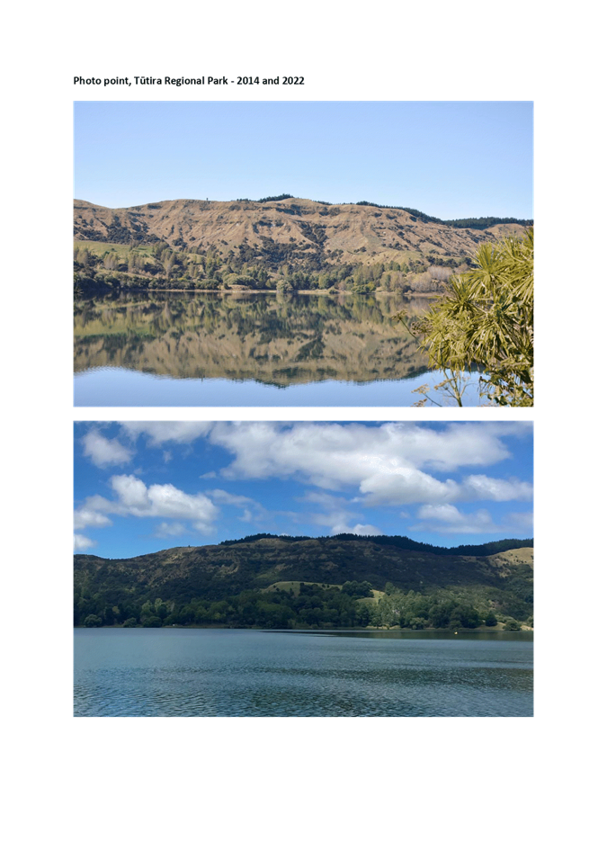
13. The Tūtira mānuka
plantation has effectively revegetated 100 ha of erosion-prone soils (12%
of the catchment draining to Lake Tūtira) in one of the most sensitive
catchments (in terms of environmental, cultural and recreational values) in
Hawke’s Bay.
Smart sustainable landuse
14. The HBRC Forests are all
multi-use properties. As well as the financial returns they generate via carbon
sequestration and log sales, they play important roles in the communities in
which they are situated. Forest management decisions are made in consideration
of all the various values and objectives of the properties.
15. The Tūtira mānuka
plantation is enabling a transition to native forest at a projected 8% IRR over
50 years. This is not as high a return as exotic plantation forestry could achieve,
but is a much more suitable use for the land given the overriding soil
conservation, recreation, and cultural objectives. It is also more than was
achieved through grazing the land.
16. The plantation has made a
significant contribution to the development of sustainable landuse options
nationally. As the only plantation of 100ha or more at that time, it was an
important case study and research site in the High Performance Mānuka
Plantations PGP Programme, which ran from
2011 - 2018 and in which HBRC
was a key investor. It was also one of two key sites used by Landcare Research
scientists in assessing the erosion control potential of the landuse[5]. Comvita Ltd continues to
undertake its own research in the plantation to determine the factors
influencing honey production.
Healthy and functioning biodiversity
17. The Tangoio Soil
Conservation Reserve and Mahia Forest contain areas classified by HBRC’s
ecologists as ecosystem prioritisation sites. Significant areas of natives are
being planted and regenerated in the Tūtira and Waipukurau Forests, and
the Tangoio Soil Conservation Reserve over the coming years.
18. The mānuka plantation
has significantly increased the area of indigenous vegetation in the Lake
Tūtira catchment. Mānuka is a primary colonising species and creates
the conditions for other secondary species to establish and emerge through it
over time, leading eventually to mature native forest.
Sustainable
services and infrastructure
19. The Mahia
Forest provides an important wastewater treatment function to the Mahia
Community, and the Waipukurau Forest (also known as Gum Trees Mountain Bike
Park) is a popular recreational venue and attraction to the town. Management of
the Tangoio Soil Conservation Reserve is very important in ensuring the ongoing
integrity of the section of State Highway 2 that runs through it. Due to access
limitations, the Waihapua Forest Park has not yet been developed, but there is
strong support for this in the surrounding Tūtira community (as previously
represented
by the now disbanded ‘Tūtira Visionary Group’).
20. In increasing
soil protection in the event of significant rainfall events, the Tūtira
mānuka plantation contributes to the protection of the landscape,
infrastructure and services of the Regional Park (attached). The plantation aligns with
other significant work to conserve soils and water quality in the Tūtira
catchment, including the Maungaharuru Tangitū-led Tūtira Mai i
Ngā Iwi and Te Waiū o Tūtira projects, and provides
valuable lessons for the Right Tree, Right Place Project and HBRC’s
objectives in promoting regional afforestation.
Background
Tangoio Soil Conservation Reserve
21. The Tangoio Soil
Conservation Reserve comprises 550ha adjacent to State Highway 2 between
Tangoio and Tūtira. It was acquired by the Crown in 1946 for the
protection of the Highway, following ongoing closures due to slips, most
notably the ‘Anzac Storm’ of 1938 which caused the Highway to be
closed for a period of months.
22. The Reserve was managed in
turn by a series of Government departments, before this responsibility passed
to the Hawke’s Bay Catchment Board and then its successor HBRC in 1989 as
required by Section 16 of the Act:
22.1. “Every
soil conservation reserve shall be under the control and management of the Board within
whose district it is situated, and the Board
shall manage and control the reserve in such manner as in its opinion will best
conserve the soil of the reserve and prevent injury to other land.”
23. Currently, 58% of the
Reserve’s area (320ha) is in commercial forestry and the remainder in
varying stages of reversion to native forest. Returns from the commercial
forestry are held in a Reserve Fund, which is used to entirely fund the
management of the Reserve - no ratepayer funds are used in the management of
the Reserve.
24. Budgets are reviewed every
3 years and cashflows modelled over 40 years to ensure the ongoing
sustainability of the Reserve Fund. As required by Sections 21-23 of the
Maungaharuru Tangitū Hapū Claims Settlement Act (2014), surplus funds
not required for Reserve management are transferred to a ‘Catchments
Fund’ where they available for carrying out soil conservation projects in
the surrounding catchments in partnership with the Maungaharuru Tangitū
Trust (MTT).
25. To date, $320,000 of
Reserve Funds have helped leverage some $6 million in funding for the MTT-led
projects Tūtira
Mai Ngā Iwi, Te
Waiū o Tūtira, and Kia eke Te Ngārue, Kia eke Arapawanui.
26. A Mana Enhancing Agreement
signed with MTT in 2016 requires HBRC to maximise training and employment
opportunities for MTT in the Reserve, and for HBRC and MTT to agree the
Reserve’s three-yearly management plans.
27. As the forests on the
Reserve were established prior to 1990, they are not eligible for entry in the
Emissions Trading Scheme and earning NZU.
Forests
owned by HBRC
River Berms
28. Around 24ha of forest is
planted on river berms around the region. Generally, soils are very stony and
conditions for tree growth are poor in these sites. River berms are also
invariably weed hot spots and control of these in newly-established plantings
can be challenging.
29. Despite these challenges,
forests are a good use for the many unused hectares of river berm land
controlled by HBRC. As well as the revenue from carbon and logs, tree canopies
assist in shading out the various weeds over time and negate the need for
grazing and the associated risks of nutrient loss in the free-draining gravel
soils. The flat terrain ensures low logging costs with no tracking and
subsequently low risk of sediment loss.
30. 6ha of the river berm
forests are radiata pine established in the mid to late 1990s. The other 18ha
is a 2021 planting of radiata pine (14ha) and Eucalyptus bosistoana
(4ha) on the left bank of the Waipawa River off Walker Road.
31. While the Walker Road
planting is too newly established for registration in the emissions trading
scheme, HBRC’s extensive willow plantings received a one-off allocation
of 14,907 pre-1990 NZU in 2008.
Joint
Venture Forests
32. Between 1994 and 2000, HBRC
entered into 10 joint ventures with landowners across the region to establish
radiata pine plantations on some 190 hectares of erosion-prone land. The joint
venture contracts expire on harvest of the trees.
Table
1: HBRC Joint Venture Erosion Control Forests
|
Owner
|
YOE
|
Logging Date (at 30yrs)
|
Ha
|
Estimated Ha Harvestable
|
HBRC share
|
Estimated HBRC revenue
|
|
Netherton Station
|
1995
|
2025
|
29
|
14
|
14%
|
$35,000
|
|
McRae Trust
|
1995
|
2025
|
9.5
|
9.5
|
13%
|
$30,875
|
|
Roy Stoddart
|
1995
|
2025
|
40
|
4
|
15%
|
$
-
|
|
Parsons Estate
|
1996
|
2026
|
22.6
|
22.6
|
22.6%
|
$127,690
|
|
Beamish
|
1996
|
-
|
5.4
|
0
|
18%
|
$
-
|
|
Waipari Station (Kairākau)
|
1997
|
2027
|
20
|
20
|
16.6%
|
$83,000
|
|
Lloyd and Virginia Cave
|
1997
|
2027
|
30
|
30
|
13%
|
$97,500
|
|
Bruce Goldstone
|
2000
|
2030
|
4.5
|
4.5
|
13%
|
$14,625
|
|
Waipari Station (Glengarry)
|
2000
|
2030
|
20
|
20
|
14%
|
$70,000
|
|
Haupouri Station
|
2000
|
_
|
8.4
|
0
|
18%
|
$
-
|
|
Totals
|
|
|
189.4
|
124.6
|
|
$535,385
|
33. Though erosion control was
HBRC’s primary objective, the agreements anticipated the forests would
eventually be harvested and generate a financial return. The objective of the
joint venture contracts is stated in Clause 1.1 of each:
33.1. “The goal of the
parties hereto is the establishment and management of the Erosion Control
Plantation, which is to be planted with rapidly growing exotic timber species,
for a rotation period to ensure that the land within the Erosion Control
Plantation is managed and harvested in a manner which will minimise the erosion
impacts”.
34. More recently, staff have
agreed with landowners that approximately 64ha of the joint ventures will not
be harvested as the environmental impacts would be too great. Staff are looking
into ways to assist the joint venture partners to revert the unharvested
forests to native over time, either through assisting registration of the trees
in the ETS and using NZUs earned to fund the work, or by using some of the
revenue earned in harvesting the better JV forests.
35. Management objectives for
the joint venture forests are listed in the HBRC Forest Estate 2021-2031
Management Plan as:
35.1. To ensure where harvest is
environmentally and economically feasible, it is carried out with minimal soil
conservation or environmental impacts
35.2. To assist landowners in
transitioning harvested sites to a sustainable post-harvest landuse
35.3. To assist landowners to
transition to permanent native forest where harvest is not environmentally or
economically feasible
35.4. To maximise financial
returns from the forests without compromising the above objectives.
Tūtira
Regional Park Pine Forest
36. Between 1991-1993, 78ha of
pine forest was established on the Tūtira Regional Park prior to HBRC
purchasing the property, and a further 36ha immediately after. All were
established primarily for soil conservation following the devastation wreaked
by Cyclone Bola (attached), with eventual financial returns from harvest being
an important secondary objective.
37. The forest is currently in
the process of being harvested and afterwards approximately 50% will be
converted to native forest for permanent retirement. Council papers relating to
the harvest procurement process were presented to EICC on 19 June 2019 and
regarding the replanting on 3 February 2021.
38. Management objectives for
the Tūtira Forest are listed in the 2021-2031
HBRC Forest Estate Management Plan as:
38.1. To manage the forest and
plantation in a way that best supports the soil conservation, biodiversity,
recreational, cultural and aesthetic values of the Regional Park
38.2. To maximise soil
conservation and minimise sediment loss to waterways and Lakes Tūtira and
Waikōpiro
38.3. To facilitate reversion to
native forest over time
38.4. To enhance biodiversity
values on the property and create connections to other habitat in the district
38.5. To maximise financial
returns from the Forest while not compromising any of the above.
Tūtira Regional Park Mānuka
Plantation
39. Since its purchase by HBRC
in 1998, successive management plans for the Tūtira Regional Park had provided for the reversion of
the 140ha of steep land above the lakes to native forest. This was seen
to be the most appropriate landcover given the various soil conservation,
recreation, biodiversity and cultural values and objectives of the property.
40. Initially it was proposed
to revert the land by scaling back grazing intensity, thereby allowing
mānuka and kanuka to establish while preventing large areas of rank grass
and weeds from developing.
41. By 2010, a strong and
growing market in mānuka honey had led to discussion around the
feasibility and potentially greater profitability (relative to the standard
practice of collecting honey from wild and unimproved mānuka) of
establishing plantations of mānuka bred specifically for high UMF*[6]. In 2011, HBRC became an
investor in the High Performance Mānuka Plantation Research Programme
alongside industry and government agency partners.
42. The Tūtira mānuka
plantation was established under the umbrella of this programme. The objectives
of the plantation were to speed the reversion to native occurring naturally,
trial the viability of mānuka plantations as an alternative and more
sustainable landuse option to grazing or plantation forestry on steep and/or
eroding hill country, and use the results to inform landowners and a planned
HBRC ‘Trees on Farms’ regional afforestation programme, all while
making a greater than 7% return on investment.
43. Consultants advising on the
venture considered HBRC’s threshold ROI of 7% would be easily achieved
and that the IRR was likely to be around 19.5%. This advice was given with the
caveat …”it should be pointed out that no large-scale areas of
known high UMF variety mānuka have been established. Thus, costs and
returns to date are best estimates[7]”.
44. Ultimately, some 104ha of
mānuka were successfully established. The seedlings were supplied by
Comvita Ltd and had been bred for high UMF levels and for the timing of their
flowering.
45. A contract signed by HBRC
and Comvita in 2012 gave Comvita exclusive rights to beekeeping on the
property. The contract is reviewed every 7 years, with the last review having
been carried out in 2019. Given the high percentage of high UMF honey in the
previous year, in the 2019 review HBRC negotiated a change from a fixed 18.5%
percent share of honey revenue to the use of a ‘sliding scale’,
with percentage share of revenue based on the UMF value of the honey.
Table 2: Sliding Scale, HBRC revenue share
|
UMF
|
HBRC Share of Net Revenue
|
|
UMF <5
UMF 5-8
UMF 8-11
UMF 11-15
UMF 15+
|
5%
10%
20%
30%
35%
|
46. The first commercial
harvest from the plantation occurred in 2018 and has continued annually since.
Key metrics are shown in Table 2 below. The 2020-2021 season harvest was badly
affected by poor weather and triggered the floor payment of $50 per hive.
47. Preliminary results from
the 2022 harvest indicate an improved return this year. Hive placement and
removal was aligned more strictly to the main nectar flow, resulting in a
higher percentage (estimated ~80%) of monofloral honey. UMF levels are sitting
in the range 4-6, with estimated final levels of 7-9 after the 10-month presale
storage period. Mānuka honey is stored for a period of time prior to sale
to allow greater levels of UMF to be converted from its chemical precursor
(DHA).
48. The improved timing was
made possible by using a helicopter to place hives in locations where
previously track limitations had restricted vehicle access in wet ground
conditions. It remains to be seen whether the helicopter cost is justified by
the increased honey returns. Once the season’s final harvest report is
received, staff will assess the costs and benefits of improving track access
for greater returns. Given the overriding soil conservation and aesthetic
considerations, doing so would only be considered if the impacts on these were
minimal.
Table 3: Key Metrics of Harvest to Date,
Tūtira Plantation
|
|
Hive numbers
|
Kg Honey (total)
|
Kg Honey (per hive)
|
% UMF 10 or higher
(after x months storage)
|
HBRC Return (excl
GST)
|
Initial forecast in
business case
|
|
2018
|
72
|
1,977
|
27
|
13%
|
$6,334
|
$19,384
|
|
2019
|
72
|
2,187
|
30
|
0
|
$6,561
|
$24,829
|
|
2020
|
96
|
5,598
|
58
|
0
|
$5,835
|
$28,314
|
|
2021
|
112
|
542
|
5
|
0
|
$5,600
|
$28,314
|
|
2022 (Preliminary
results)
|
100
|
1,813
|
18
|
To be confirmed
|
To be confirmed
|
$28,314
|
49. As shown in Table 3,
notwithstanding the potential improvements in the current season, honey returns
have been short of those predicted in the initial business proposition
presented to council in each year to date. A particularly poor 2020-2021 season
was reported by staff in the August 2021 ‘Significant Activities’
update to Council, where it was picked up and reported on by media in an
article titled Hawke's Bay Regional Council's mānuka honey venture
makes dismal returns and published in Stuff online 12 Nov 2021. A paper was
presented to Finance, Audit and Risk Sub-committee (FARS) on 2 March 2022
addressing concerns raised by the article.
Waihapua
Forest Park
50. The Waihapua property had
been of interest to HBRC for many years before the opportunity to purchase it
arose in 2009. The reasons were summarised by a sub-committee of Council
charged with forming a strategy statement for the property in the same year:
50.1. “It’s
significant open space and strategic value given its location adjacent to key
amenity areas and Tangoio Soil Conservation Reserve; its potential to
demonstrate land use options relating to soil conservation and waterways; its
severely eroded nature (Attached); and its commercial advantages associated
with timber and carbon trading.”
51. Following purchase, Council
developed the following Goal for the property:
51.1. “A profitable
working example of integrated and multi-functional land use centred on sequestration
and soil conservation forestry consistent with wider social, amenity,
environmental and economic values and opportunities within the Tutira
area.”
52. Council also identified key
functions for the property as:
52.1. ‘social engagement,
amenity values, recreation, the improvement of water quality, soil
conservation, biodiversity and indigenous ecological values, research, and
demonstration.”
53. Council was advised at the
time an internal rate of return of 6-7% was likely.
54. The name ‘Waihapua
Forest Park’ was formally adopted by Council on 27 April 2011 after
advice from Maungaharuru Tangitū Trust, endorsed by the Tūtira
Visionary Group- a group formed around that time to encourage the development
of tourism and other opportunities for the Tūtira District. The name is
derived from a deep spring with special qualities found on the property.
55. Planting was planned in
conjunction with the Hawke’s Bay Branch of the New Zealand Farm Forestry
Association and carried out between 2009 and 2013. More than 25 timber species
on a range of management regimes were established (attached). There are two
dedicated trial sites on the property, one of Eucalyptus fastigata, and
the other of mixed ground durable eucalyptus species. The site-specific
planting resulted in many small compartments, useful for trial and
demonstration purposes, but significantly increasing the difficulty of logging
economically using conventional methods.
56. Approximately 30ha of the
property was deemed to be too steep and erosion-prone to establish in
production forestry or was already in the early stages of reversion to native
forest and not planted with production species on that basis.
57. As well as being envisaged
as a future recreational and educational venue in its own right, Waihapua was
seen as a key addition to a potential walkway over the corridor of public lands
stretching almost uninterrupted for some 16km from the bottom of the Tangoio
Soil Conservation Reserve in the south to the top of the Tūtira Regional
Park in the north (figure 1).
Figure 1: Concept Plan,
Tūtira Trails
58. Due to a lack of safe
access to the property, the walkway has not yet been developed and opened to
the public. The main access is through private property, but the easement only
provides for HBRC and its contractors. Other options are possible, but
difficult to form tracks in given the steep and eroding nature of the land.
Access from State Highway 2 is hazardous and would require investment before
opening to the public.
59. Management objectives are
listed in the HBRC Forest Estate 2021-2031 Management Plan as:
59.1. To maintain soil
conservation on the property and minimise sediment loss to the Waikoau River
and erosion impacts on State Highway 2
59.2. To establish and maintain
secure access to the property for recreational use
59.3. To establish and maintain
links from the property to Guthrie-Smith Arboretum and Education Trust and
Tūtira Regional Park
59.4. To enhance biodiversity
values on the property, creating connections to other habitat in the District
59.5. To demonstrate alternative
commercial forest species and support the development of their genetics and
markets
59.6. To maximise financial
returns from the Forest while not compromising any of the above.
Mahia
Forest
60. The Mahia Forest property
was purchased in 2009 primarily as a receiving environment for Mahia
township’s treated wastewater, but also as a carbon and timber investment
property.
61. Unlike the Central
Hawke’s Bay Wastewater Forests, Wairoa District Council (WDC) did proceed
with irrigating treated wastewater into the Mahia Forest.
62. After being pumped over the
hill from the township, the wastewater passes through a series of three
settlement ponds, before being screened and pumped to irrigation fields in the
forest. Irrigation in the different fields is alternated to allow them to fully
dry out between applications and maintain the treatment capacity of the soils.
Of the total 50ha land area, and 35ha forested area, approximately 11ha is used
to treat wastewater.
63. A key risk in
wastewater-irrigated forests is exceeding the treatment capacity of the soil.
This was a major reason for the dissolution of Rotorua’s Whakarewarewa
Forest wastewater irrigation scheme after 28 years of operation. This risk is
managed in the Mahia Forest through ongoing monitoring of tree health,
application volumes and soil moisture levels. The risk to the environment
is managed by monitoring water quality parameters in the stream leaving the forest.
Figure 2: Nitrogen
removed from Wastewater in the Whakarewarewa Land Treatment System Over Time[8]
64. Management objectives are
listed in the HBRC Forest Estate 2021-2031 Management Plan as:
64.1. To maintain the ability of
the land to receive and effectively treat wastewater from the Mahia Township
for the foreseeable future.
64.2. To protect cultural values
within the Forest, and in particular the registered archaeological sites.
64.3. To enhance biodiversity
values in the Forest, building on the work of the Predator Free Mahia Project.
64.4. To maximise financial
returns from the Forest while not compromising any of the above.
Central
Hawke’s Bay Forests: Waipukurau and Waipawa
65. The two Central
Hawke’s Bay properties were purchased between 2009 – 2010 and, as
with the Mahia Forest, were established in forest for the purpose of safely
disposing of treated wastewater from the townships while earning revenue from
carbon sequestration and high value hardwood timber.
66. Central Hawke’s Bay
District Council opted for another option to deal with their wastewater, and
the forests have never been used for this purpose.
67. In 2009 HBRC signed an MoU
with the Rotary Rivers Pathway Trust, allowing the Trust use of the Waipukurau
Forest for mountain biking for a term of 30 years. Since that time, the Trust
has established approximately 15km of mountain bike tracks in the forest, with
a further 5km scheduled for completion in the coming months. The Park is ridden
an estimated 10,000 times annually.
68. Currently, the Waipawa
Forest has only a commercial purpose, though two requests from the community
have been made for its use. The Central Hawkes Bay District Council has
requested the use of the forest for disposing of sludge remaining after their
sewerage treatment, and the Hawke’s Bay Riders’ Club has requested
its use for horse rides and potentially grazing.
69. Management objectives for
the Central Hawke’s Bay Forests are listed in the HBRC Forest Estate
2021-2031 Management Plan as:
69.1. To maintain the ability of
the land to receive and effectively treat Central Hawke’s Bay wastewater
if required.
69.2. To maintain the
recreational value of the Waipukurau Forest to the Central Hawke’s Bay
Community.
69.3. To enhance biodiversity
values in the Waipukurau, creating connections to habitat along the Tukituki
River.
69.4. To maximise financial
returns from the Forests while not compromising any of the above.
Management
70. Currently, management of
the Tangoio Soil Conservation Reserve, HBRC Forests, and Tūtira
mānuka plantation is carried out by a Forests and Reserves Officer, in the
Open Spaces Team of the Asset Management Group of HBRC.
71. Forest management decisions
are made according to HBRC’s standard financial delegations and
significance criteria. Detailed management plans for the Tangoio Soil
Conservation Reserve and HBRC Forests align with the LTP period and set out
forest objectives and policies. The plans have been reviewed and approved by
two reputable Hawke‘s Bay foresters as well as the Team Leader Open
Spaces and Group Manager, Asset Management.
72. Due to the high complexity
of HBRC’s carbon portfolio and the significant costs of calculation
errors (both in terms of fines and impacts on decisions), carbon accounting is
still contracted to an external consultant. Similarly, harvest in sensitive
environments is contracted to harvest managers.
73. A position of both forestry
regulator and manager puts HBRC in an unusual situation and entails risks of
the regulator being held to account for its own practices, a risk that is
greater than that of many other local authorities given the erosion-prone and
environmentally-sensitive nature of a large area of its forests. However, this is
not an unreasonable expectation and helps HBRC to keep skin in the game of
forestry, form solid working relationships with industry, and sustain expertise
within the organisation in making decisions and advising on matters relating to
forestry.
Discussion
Key Issues
Alternative species
74. HBRC forests contain a wide
range of species as shown in Figure 3 below. Though generally alternative
species don’t provide the certainty or level of harvest returns of
radiata pine, in some situations, other priorities such as aesthetic value and carbon
sequestration have taken precedence. Past replanting decisions, particularly at
Waihapua, also reflect Council’s desire to support species
diversification within the New Zealand Forest Industry.
|
|
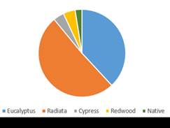
|
|
Figure 3:
Species mix in TSCR (left) and HBRC Forests (right)
|
75. The current HBRC Forest
Estate Management Plan species selection policy attempts to balance these
objectives with managing risk in the returns on investment of ratepayer funds
(particularly given the increasing area returning to native) by maintaining radiata
pine at around 50% of the commercial area of the estate with the remainder
allocated to alternative species. Given the importance of maintaining the
sustainability of the TSCR reserve fund and Catchments Fund and the
progressively decreasing area of commercial forest, the species selection
policy there is 75% radiata pine, once again applied to the commercial area
only. This ratio will be revised at the next management plan period (3-yearly
to coincide with the LTP period), particularly given the recent high prices for
some cypress species.
76. The development of
alternative timber species has historically been limited in large part by
limited resources spread widely over a variety of species. Recently, leadership
in projects such as the Specialty Wood Products Partnership (SWPP), New Zealand
Drylands Forest Initiative (NZDFI), and the Cypress Interest Group of the New
Zealand Farm Forestry Association has focused effort and resources more
effectively behind the most promising species.
77. Small volumes of
alternative species have become available for milling recently - Eucalyptus
fastigata were situated amongst radiata pine logged at Tangoio, and large Eucalyptus
regnans and Juglans nigra (black walnut) will be felled soon in a
land clearance exercise, also at Tangoio. In general though, the alternative
species are all young and, particularly as alternative species have longer
rotation ages than radiata pine, no significant volumes will become available
for harvest for at least another 15 years. It is difficult to model financial
returns from alternative species given the small volumes traded and subsequent
lack of market data.
78. Under current market
conditions, the large areas of Eucalyptus fastigata and regnans
on the HBRC estate are uneconomic to harvest and are a carbon crop only.
Although the timber able to be effectively processed is of reasonable quality,
markets for the logs are very limited and prices very low. This is mostly due
to very poor recovery of sawn timber from logs (~50%) due to issues with
warping, cell collapse and splitting during and after milling, and the time and
handling in trying to minimise these issues. It is possible markets for these
species may develop in the future as technology in wood biofuels, LVL
(laminated veneer lumber), and CLT (cross laminated timber) develops.
79. Species selection
objectives and policies are listed in the HBRC Forest Estate Management Plan
as:
Objectives
79.1. To grow species appropriate
for site and best meeting the Council’s financial and non-financial
forest management objectives
79.2. To support well founded
species diversification of the New Zealand Forest Estate.
Policy
79.3. Select native species in
preference to exotic where they are equally able to achieve the
given management objectives.
79.4. Confirm replanting species
selection choices prior to harvest based on the most current advice and
information available and on the criteria of:
79.4.1. Alignment with primary
management objective of the land, ie either erosion control or wastewater
treatment, and secondarily recreational access
79.4.2. Site suitability
79.4.3. Financial returns on
investment
79.4.4. Contribution to regional
economy (regional processing opportunities).
79.4.5. Aesthetics (in high public
use areas)
79.4.6. Strategic alignment with
industry initiatives and HBRC goals.
Carbon forests and carbon trading
80. Carbon farming was a
significant factor in the purchase of the Waihapua, Mahia, Waipukurau and
Waipawa forests and the decision to plant large areas of fast-growing
eucalyptus species in them. Apart from the highest erosion susceptibility land
at Waihapua, they weren’t envisaged as being permanent forests, and
timber production was listed as a complementary objective, though as described
previously this will be difficult to achieve.
81. The NZU balance earned in
the forests to date and modelled into the future is shown in figure 4 below. The dotted line indicates the decreasing accuracy in
predicting NZU balances at extended timelines. At the current price of
$76 per NZU, the balance of 146,400 post 1989 NZU and
14,907 pre 1990 NZU is currently worth $12 million.
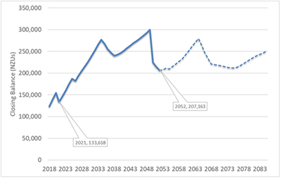
Figure 4: Forecast HBRC NZU balance to
2083
82. No NZU from the HBRC carbon
holding account have been sold to date, but this will potentially change soon
with NZU proposed to be sold to finance the recently-created Climate Action
Ambassador role.
83. FARS Committee 2 March 2022
asked that a clear carbon policy be formed prior to any NZU sales and staff are
currently in the process of doing so.
84. Particularly if carbon
continues to increase in value over time (figure 5), the carbon policy, and
specifically whether NZU are traded and at what times and volumes, will have a
significant impact on returns and therefore decision-making in HBRC’s
forest estate.

Figure
5: Change in NZU price over time
85. For example, Table 4 below
shows the IRR that would be achieved from the Tūtira mānuka
plantation under 3 scenarios and demonstrates the significant impact NZU sales
have on the profitability of the plantation.
Table 4: IRR at different NZU Sale Scenarios
|
Years earned
|
NZU Price at that
time
|
Scenario 1:
First NZU sales in 2022
|
Scenario 2:
NZU sold as earned
|
Scenario 3:
No NZU sales
|
|
2018
|
$23
|
-
|
$19,458
|
-
|
|
2019
|
$25
|
-
|
$10,650
|
-
|
|
2022
|
$82
|
$169,084
|
$64,780
|
-
|
|
Total
|
$169,084
|
$91,560
|
-
|
|
IRR over 50 years
|
8%
|
8%
|
NA
$830,000 loss
|
Central
Hawke’s Bay Eucalyptus regnans
86. Large areas of eucalyptus
regnans (approximately 75ha) were planted in the establishment of the Central
Hawke’s Bay forests. As a rapidly growing species, E. regnans
takes in large volumes of water and nutrients and is well-suited to wastewater
irrigation. In addition, stands of healthy E. regnans hold more carbon
than any other forest type in the world making them well suited to carbon
forestry.
87. However, without irrigation
E. regnans isn’t a suitable species for the CHB climate. The
rainfall band in its natural range in Tasmania and southern Victoria is
900-1100 mm[9], whereas the
five year average for Waipukurau is 690mm, with recent lows of 550 mm
in 2019 and 530 mm in 2020.
88. Approximately 3.5ha (8%) of
the E. regnans in the Waipukurau Forest and 2ha (5%) of the E.
regnans in the Waipawa Forest died in the 2019-2020 and 2020-2021 summer
droughts. Tree mortality was worst in areas with northern aspects and the
poorest soils. These areas have been cleared for replanting in more suitable
species, but particularly given the predicted impacts of climate change, more
deaths are likely in the future.
89. There are no markets for
the trees at this age. Due to their size, a lot of manual handling is involved
in processing and carting them for firewood. Firewood merchants these days
prefer large diameter logs processed using automated machinery, allowing many
cubic metres of wood to be carted and processed efficiently and with little manual
labour.
90. A minimum age of 40 years
is generally recommended before E. regnans can be sold and milled for
timber, in order to better deal with the growth stresses, splitting and warping
the species is prone to. Even then, markets for the trees are very limited and
if they can be found at all they pay poorly, as described previously.
91. In addition, fire risk in
the properties is significant. The E. regnans and other eucalyptus
species in the forest are all of high flammability, and even the radiata pine
is classed as moderate in this regard. Land on the western boundary of
the Waipukurau Forest, in the direction of greatest risk due to the prevailing
wind, has been subdivided and is being sold in lifestyle blocks, and the risk
of fires being started from human activity and migrating into the property from
these properties will increase.
92. The replanting plan for the
Waipawa Forest is on hold pending a decision on whether HBRC is going to retain
the property or not. If the property is to be sold, staff recommend leaving the
cleared areas unplanted given purchasers may not want those areas back in
forest. If the property is retained and Council agrees to CHBDC’s request
to dispose of biosolids on it, the replanting plan will need to be made with
that in mind.
93. Members of the NZ Farm
Forestry Association and the Rotary Rivers Pathway Trust (the organisation that
has established the mountain bike tracks in the forest) were involved in
planning the replanting of the Waipukurau Forest cleared areas. The plan is
still being confirmed, but key principles at this point are:
93.1. Radiata pine isn’t
the best fit with the recreational values of the forest. Aesthetically, there
are better options, and the harvest regime for radiata pine would require
largely destroying the approximately $300,000 investment in mountain bike
tracks every thirty (30) years. Planting species able to be logged selectively
and milled in small local or portable mills for niche markets would minimise
this damage and disruption to the recreational use of the property. As the
forest is generally easy rolling contour, this method of harvest will be easily
achievable.
93.2. Deciduous trees and
broad-leaved natives are far less flammable than exotic conifers due to the
volumes of water they hold in their leaves and stems over summer periods, and
in the Waipukurau Forest this is an important factor given the issues described
previously. Poplars in particular have proven to slow wildfires in Australia when
planted in dense belts. Oaks are the deciduous species with the most
coordinated support behind their genetic and market development.
93.3. While HBRC already has a
demonstration forest and trials in the higher rainfall environment of Waihapua
(1,267mm 10-year average rainfall), the Waipukurau Forest provides an
opportunity to replicate this in a dryland environment, including the use of
lower flammability species. This is particularly relevant given the predicted
impacts of climate change.
93.4. It is important that native
vegetation is planted in the forest. Many of the eucalyptus trees will never
provide a saleable log and at present are purely a carbon crop. For the
longevity of the forest, there must be adequate native vegetation to take over
before the eucalypts become too large and unmanageable. Natives are beginning
to regenerate underneath, but this process is slow due to the low rainfall and
scarcity of native seed sources and needs to be supported. Native plants and
trees would be difficult to establish on the hard bony sites that need
replanting and will be planted more strategically in high amenity areas and in
the wetter valley bottoms.
Access
94. HBRC is dependent on access
across private land for entry to the Mahia and Waihapua Forests, and for log
truck access to the Tūtira Forest, and for access to three areas of the
Tangoio Soil Conservation Reserve. Only one of these access points is not protected
by easement.
95. To log the trees in the
Tangoio Soil Conservation Reserve above the Devil’s Elbow, access will
need to be gained across a further three properties. One of these access points
will be a one-off requirement only as the area will not be replanted in
commercial forestry, but easements will be sought for the other two given they
will be replanted in commercial trees.
Waipawa
Forest
96. The only property in the
HBRC portfolio without a clear objective at this point is the Waipawa Forest.
It is currently an underutilised and (given the Eucalyptus regnans
issues) a low-productivity asset. Given CHBDC’s interest in disposing of
biosolids derived from wastewater treatment on the property, a conversation has
been initiated with them regarding the long-term future of the site.
Impact on the Community or Council
97. With the exception
currently of the Waipawa Forest, the various forest assets managed by HBRC
provide a range of significant values to the communities they are situated in,
and decisions on their management therefore have the potential to impact
significantly on these communities.
98. Staff propose that updates
on the forestry assets are provided to Council following the end of every
financial year. Harvest reports for the mānuka plantation and any forest
that has been logged will generally be available at this time.
99. Decisions of significance will
continue to be brought to Council as per Council policy and as has been the
case with recent examples such as the Tūtira pine forest replanting plan
and the Tangoio and Tūtira pine forest harvesting procurement. At this
point in time, the decisions of significance needing to be made are whether to
divest of the Waipawa Forest and confirmation of HBRC’s carbon trading
policy.
Other Council’s experiences
100. Local authorities own or
manage 53,282 hectares (2.5 %) of the 2.1 million hectares of commercial forest
land in New Zealand for a wide range of objectives (attached). As such, there is ample
opportunity to learn from other councils’ experiences as required.
101. Though other Regional Councils have
contributed to research into mānuka plantations as a landuse, the
Tūtira plantation is the only known Council-owned mānuka plantation
in the country.
Next Steps
102. Review of Waipawa Forest to be
undertaken to determine optimal use of this asset.
103. Staff will bring a draft carbon
trading policy to Council when complete.
104. Staff will report back to Council when
the 2022 Tūtira mānuka plantation and pine forest harvest reports are
available.
Decision Making Process
105. Staff have assessed the
requirements of the Local Government Act 2002 in relation to this item and have
concluded that, as this report is for information only, the decision-making
provisions do not apply.
Recommendation
That
the Environment and Integrated Catchments Committee receives and notes the HBRC
Forestry staff report.
Authored by:
|
Michael Bassett-Foss
RTRP Project Manager
|
Ben Douglas
Forests and Reserves Officer
|
|
Russell Engelke
Team Leader Open Spaces
|
|
Approved by:
|
Chris Dolley
Group Manager Asset Management
|
Iain Maxwell
Group Manager Integrated Catchment
Management
|
Attachment/s
|
Forestry attachments
|
Attachment
1
|
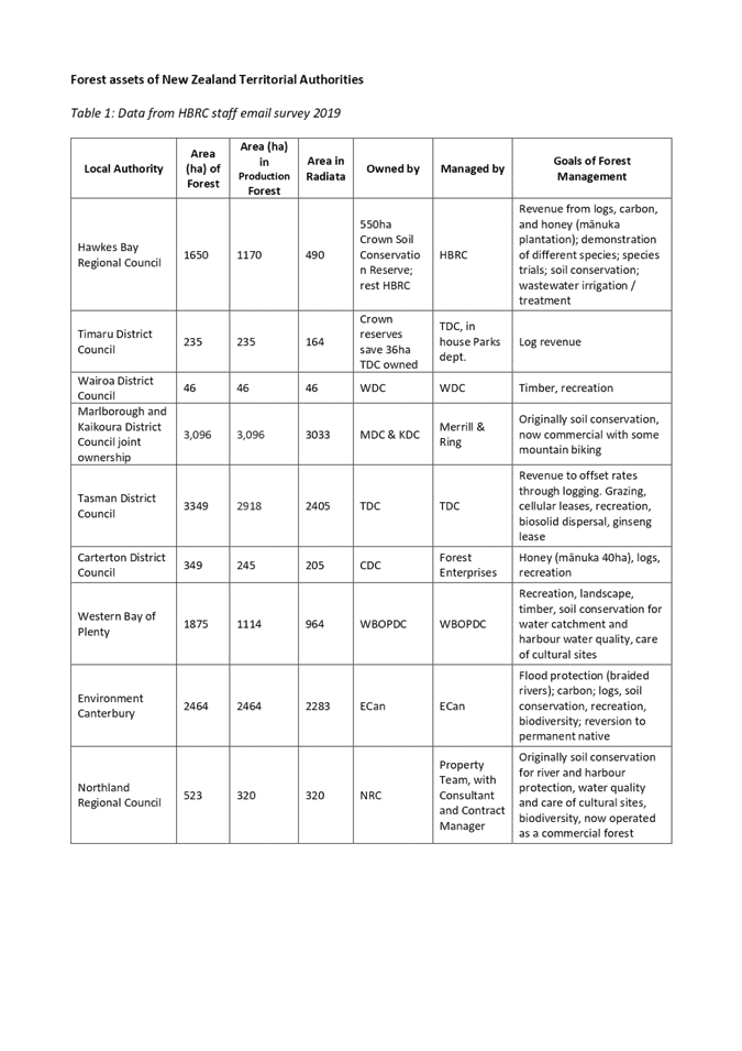
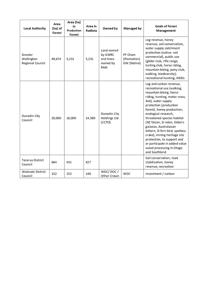
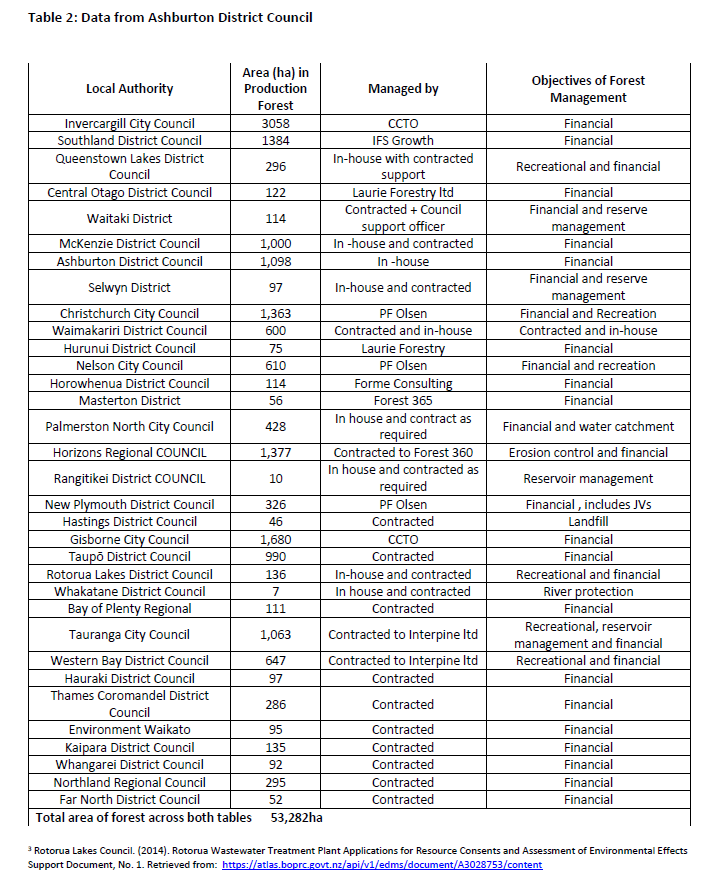
Hawke’s Bay Regional
Council
Environment
and Integrated Catchments Committee
11 May
2022
Subject: Discussion of Minor Items not
on the Agenda
Reason for Report
1. This document
has been prepared to assist Committee Members note the Minor Items Not on the
Agenda to be discussed as determined earlier in Agenda Item 6.
Williams,
B & Besednjak, T. (2007). EM112 Gumeracha Eucalypt Climate Change Trials
2007 Interim Report. Retrieved from: