HAWKE’S BAY REGIONAL
COUNCIL
23
February 2022
Subject: HBRC Internal Review – Coastal Hazards
Strategy Implementation
Reason for Report
1. This paper provides a
response to the 8 topics of internal review (Internal Review) requested by
Hawke’s Bay Regional Council (Council) at their meeting on 28 July 2021.
Background
/Discussion
2. On 28 July 2021 a paper was
presented to Council seeking agreement to the Coastal Hazards Strategy
Implementation and Execution Funding Model report which had been through the
Clifton to Tangoio Coastal Hazards Joint Committee on 4 June 2021 and Council’s
Environment and Integrated Catchments Committee on 23 June 2021.
3. On 28 July Council
resolved:
“That
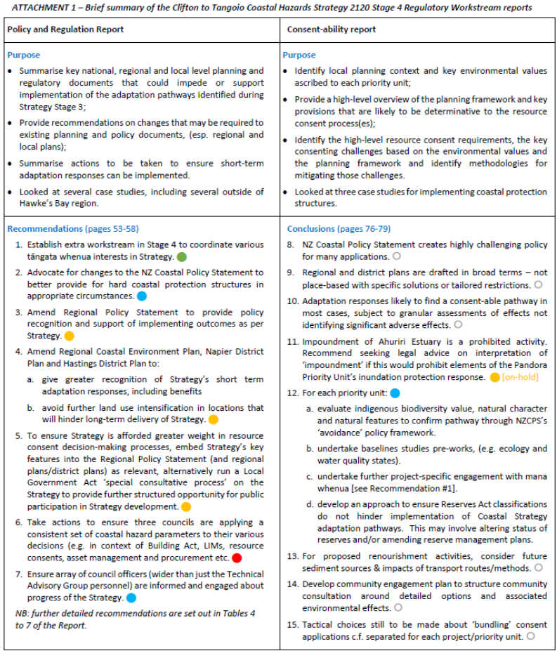
Hawke’s Bay Regional Council:
3.1. Receives and considers the
“Coastal Hazards Strategy Implementation & Execution Funding
Model” staff report.
3.2. Agrees in principle to the outcome of
the Funding Review and recommendations of the Clifton to Tangoio Coastal
Hazards Strategy Joint Committee; being:
3.2.1. Endorses the findings of the review
undertaken by Mr Raynor Asher QC titled “Review and Recommendations for
the Clifton to Tangoio Coastal Hazards Strategy Joint Committee”,
including the following key recommendations, for the purposes of commencing
consultation under s.16 of the Local Government Act 2002:
3.2.2. That the Hawke’s Bay Regional
Council takes charge of all aspects of adapting to and mitigating coastal
hazards risks on the Clifton to Tangoio Coast
3.2.3. That the Napier City Council, Hastings
District Council and Hawke’s Bay Regional Council enter into a memorandum
of understanding setting out agreed positions on this arrangement
3.2.4. That an advisory committee is formed
by elected representatives from Napier City Council, Maungaharuru-Tangitū
Trust, Hastings District Council, Mana Ahuriri, Hawke’s Bay Regional
Council and Heretaunga Tamatea Settlement Trust to support forward work
3.2.5. That a Transition Plan is prepared to
set out the timing and orderly process of transitioning functions to the
Hawke’s Bay Regional Council in accordance with the terms set out in the
memorandum of understanding.
3.3. Directs staff to prepare a draft
Memorandum of Transition between the Hawke’s Bay Regional Council, Napier
City Council and Hastings District Council that details the proposed
operational regime for implementing coastal hazards mitigation projects under
the Clifton to Tangoio Coastal Hazards Strategy, including but not limited to:
3.3.1. Recognition and acknowledgement of
legal responsibilities
3.3.2. Assessment of risk and liabilities
associated with the transfer to HBRC of the management of existing coastal
hazards mitigation assets held by Napier City Council and Hastings District
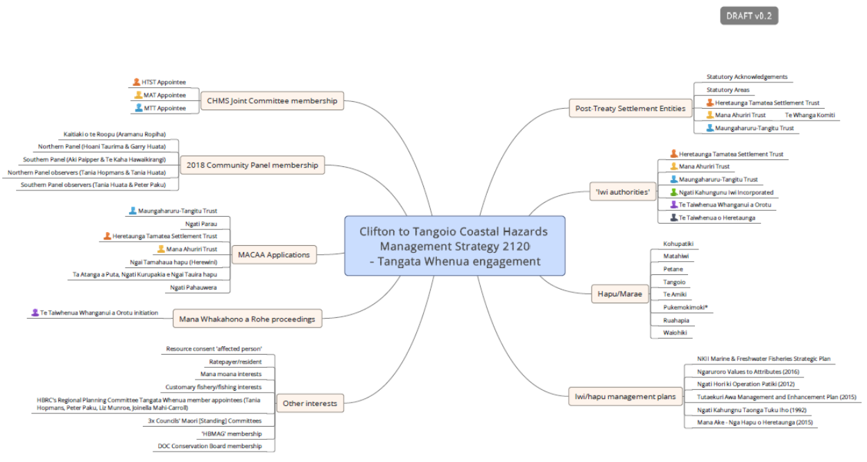
Council and the transfer of existing rock revetments at Waimarama, Clifton,
Cape View Corner and Ahuriri
3.4. Directs staff to report back to
Council on a pathway for an internal review of the following areas of HBRC in
relation to the implementation of the Coastal Hazards Strategy:
3.4.1. Organisation wide impacts
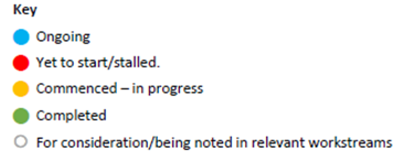
3.4.2. The most effective organisational
model for implementation
3.4.3. Suitability of policy and regulatory
framework
3.4.4. Science output requirements
3.4.5. Obligations to tangata whenua
3.4.6. Ratepayer equity, including an
assessment of the full financial cost to all ratepayers in delivering the
strategy
3.4.7. The impacts of climate change on the
adaptive pathways in light of the most recent projections
3.4.8. An assessment of the carbon footprint
arising from implementing the strategy.”
4. Further workshops were
subsequently held with Councillors to confirm the scope of the Internal Review
(topics outlined under 3.4 above).
5. This report presents each
Internal Review topic, the confirmed scope (bold italicised text) and
information collated in response.
Topic
1: Organisation Wide Impacts
Provide
an assessment of staffing requirements and structural changes required to
successfully deliver projects under the Strategy.
6. Should Council decide that
it should be responsible for delivery of the Clifton to Tangoio Coastal Hazard
Strategy then the following delivery model is proposed.
7. The delivery model is
identical to the way flood control and drainage schemes are provided across
Hawke’s Bay under a targeted rate model.
8. HBRC currently manages $206
million of flood control and drainage assets which includes civil, mechanical
and electrical assets. The upper bound of the estimate for new works proposed
under the Strategy is $26.4 million (see discussion under Topic 6 of this
report) for civil works which represents an 11% increase in asset base over a
10-year time horizon.
9. Table 1 below presents the
proposed delivery model and anticipated costs.
Table 1 Proposed delivery model and anticipated costs.
|
Group
|
Regional
Assets: Strategic Asset Management
|
Regional
Assets: Operational Asset Management
|
Regional
Projects
|
Science
(Refer to discussion under Topic 4)
|
|
Tasks
|
Progress
and update the Strategy as required
Develop
business cases for new works
Develop
an Asset Management Plan including maintenance and renewal strategy as input
to the Infrastructure Strategy and Long Term Plan
|
Monitor
and inspect existing and new structures
Detailed
engineering inspections
Monitoring
signals and triggers
Managing
operational renourishment programmes
|
Consenting
and capital project delivery
|
Strategic
assessment
Preferred
option analysis
Consent
application review (regulatory function)
Data
collection, monitoring, analysis
|
|
New Staffing
|
1 additional FTE ($150k p.a.)
|
Managed within existing team (7 FTEs)
|
1 additional FTE ($150k p.a.)
|
Some elements partially managed within existing team
Determination will be made on whether to outsource
remaining elements or increase capacity
|
|
External / specialist technical support
|
Procurement of additional specialist advice $200k p.a
|
Procurement of additional specialist advice $300k p.a
($100k for specialist advice plus $200k provision for
consent conditions)
|
Procurement of additional specialist advice funded
through cost recovery mechanism
|
Engaged where independence from consenting functions
required - Funded through cost recovery mechanism
|
10. It is noted that cost of
consenting has been built into the project estimates (Topic 6) as a key project
activity.
11. Works Group have in the
past undertaken maintenance of coastal structures for HBRC and other Councils.
It is anticipated that they can undertake some of the maintenance work required
as and when required. It is not envisaged that Works Group would scale up for
the provision of maintenance renourishment as envisioned by the current
pathways. This work typically requires large volumes of shingle over relatively
short time periods and is most efficiently delivered by the contracting
industry.
12. The estimated additional
funding described here has been included in the financial assessment tables.
Financial information will be updated as the strategy processes through
consenting, design and construction phases.
Identify
the number of new Full Time Equivalent (FTE) roles considered necessary, based
on FTE requirements to deliver capital works programmes under HBRC’s
flood control schemes.
13. The estimate for FTE staff
required to deliver the Clifton to Tangoio Strategy is 2 (refer Table 1)
in addition to specialist consultant and contracted resources the costs of
which have been accounted for in strategy estimates.
14. This resource is based on
an assumption that the program is optimised for a smooth delivery profile.
Should significant construction be required over a short period of time (for
example IRG deliver) then additional project managers will be required.
Discuss
assumption that resourcing levels will be designed to address project delivery,
operations & maintenance and monitoring.
15. Detailed design and
consenting work to be mostly outsourced as this is short duration and
specialist in nature and there are benefits to maintaining independence from
Council’s regularly functions.
Topic
2: The most effective organisational model for implementation
Describe
how physical works programmes would be effectively implemented in practice.
16. The physical work programs
would be delivered through the following generic asset management process.
16.1. The asset management plan
will be based on the work of the Strategy and clearly outline an investment
pathway, the primary option(s) to be delivered in an approximate timeline, with
triggers identified for initiation of each project. This investment profile
will be reflected in the Infrastructure Strategy, the Financial Strategy and
the approved LTP. The Infrastructure Strategy is required to outline a minimum
of 30 year investment plan for each activity.
16.2. Staff will monitor the
project triggers and when triggers are met will initiate the capital works
project by defining the key attributes, activities and outcomes required. Where
background data collection may be required for consenting purposes this will be
commenced as an early deliverable without committing to the full project at
that time.
16.3. The project will be
assigned to a Regional Projects project manager who will develop a detailed
work plan, schedule, procurement plan, cashflow and review the project estimate
using current pricing information.
16.4. The project manager with
high level support from the asset manager and detailed support from specialist
consultants and contractors will deliver the work packages required for
delivery of the asset. This would typically include:
16.4.1. Definition - document precisely what
is required and what are the key steps of delivery
16.4.2. Procurement strategy - describing how the
various work packages will be procured and the approximate value of each work
package
16.4.3. Design - which would consist of
concept, engineering design and detailed design
16.4.4. External approvals - including any land matters
and consents
16.4.5. Construction - likely seasonal
16.4.6. Handover - to operations including
as built drawings, operational and maintenance plans and any warranties
16.4.7. Project Closeout - financial closeout of the
project.
Discuss delivery model,
which is to be based on HBRC flood control works; key components include that
the works will be led out of HBRC’s Asset Management Group, funding is
confirmed through usual Long Term Plan processes, with triggers and thresholds
driving the actual work programme in any given year.
17. It is recommend that Asset
Management Group would deliver the coastal strategy through minor amendments to
its existing structure using the same core asset management framework that the
delivers flood control and drainage activities.
18. All funding requirements
for the new activity will be described in a new Coastal Asset Management Plan
which will feed into the Infrastructure Strategy, Financial Strategy and Long
Term Plan. All decisions on the final shape of Coastal Strategy will be agreed
by Council through adopting the Long Term Plan every 3 years, with ability to
adjust through the annual plan cycle.
19. Although the major
investments for the coastal strategy will be outlined in Infrastructure and LTP
based on the best information at the time, projects will only be commenced when
they meet their trigger conditions. This is best practice Asset Management to
only invest in new infrastructure when it is required. This means that
adjustments will be made to the investment profile and thus project delivery
based on the monitoring of the coastal environment and sea level rise. Because
the strategy is adaptive, adjustment, particularly in the 10-30 year view
should be expected.
Topic
3: Suitability of policy and regulatory framework
Summarise
findings of reports by Mitchell Daysh Limited looking at the suitability of the
existing policy framework and consentability issues for works proposed under
the Strategy.
20. The Strategy’s Stage
4 Regulatory Workstream reports by Mitchell Daysh Limited in 2020 focused on
two principal tasks:
20.1. Summarising key planning
and regulatory documents that could impede or support implementation of the
preferred pathways including a consideration of 'moral hazard’ risks;
and
20.2. Summarising actions to
ensure short-term adaptation responses can be implemented, including use of
several case studies.
21. Attachment One provides a summary of
those two reports and their recommendations/conclusions. This same
summary was presented to the 19 November 2021 meeting of the Clifton to Tangoio
Coastal Hazards Strategy Joint Committee.
Present
scope for next phase of work under the Regulatory Workstream which will respond
to recommendations made in the Mitchell Daysh reports.
22. The Mitchell Daysh Limited
reports make recommendations focussing on opportunities for amendments to
existing planning documents under the RMA, i.e.:
22.1. Hastings District Plan
22.2. Napier District Plan
22.3. Hawke’s Bay Regional
Resource Management Plan (including the Regional Policy Statement) and
22.4. Hawke’s Bay Regional Coastal
Environment Plan.
23. In particular, the Policy
and Regulatory Review Report included the following recommendation:
23.1. “Amendments will be
required to the Regional Coastal Environment Plan, the Hastings District Plan
and City of Napier District Plan to ensure the objectives, policies and methods
within these documents enable the outcomes sought by the Strategy. This is
twofold –
[a] greater recognition of
the implementation of short-term hazard adaptation responses (including
benefits) and
[b] the avoidance of future
land use intensification that will hinder long term delivery of the Strategy
and increase moral hazard.”
24. There are two key current
or emerging opportunities for incorporating elements of the Stage 4 workstream recommendations
into statutory planning documents.
Review
of Napier District Plan
25. An opportunity to embed
provisions proposed Napier District Plan to:
25.1. Give greater recognition of
the Strategy’s short term adaptation responses, including benefits
25.2. Avoid further land use
intensification in locations that will hinder long-term delivery of the
Strategy.
25.3. Provisions could be
inserted during the drafting phase (now to mid-2022) and/or via formal
submissions after the new proposed district plan is publicly notified.
Review
of HBRC’s RMA plans (Kotahi)
26. An opportunity to embed
provisions in the Regional Policy Statement (RPS), Regional Coastal Environment
Plan and the remaining parts of the Regional Resource Management Plan to:
26.1. Provide policy recognition
and support of implementing outcomes as per Strategy
26.2. Give greater recognition of
the Strategy’s short term adaptation responses, including benefits
26.3. Avoid further land use
intensification in locations that will hinder long-term delivery of the
Strategy
26.4. To ensure the Strategy is
afforded greater weight in resource consent decision-making processes, embed
Strategy’s key features into the Regional Policy Statement (and regional
plans) as relevant, alternatively run a Local Government Act ‘special
consultative process’ on the Strategy to provide further structured
opportunity for public participation in Strategy development
26.5. Timing wise, Kotahi
programme is aiming for public notification as a proposed plan in late 2024.
27. Recommendations from the
Strategy’s Stage 4 Regulatory Workstream have been added to the Kotahi
project’s ‘to-do-list’ for the appropriate policy options
evaluation, drafting and public consultation. But the Kotahi Plan alone cannot
deliver all of the relevant policy interventions due to allocation of roles and
functions under the RMA to territorial authorities and the regional council.
28. Council’s 2021-31
Long Term Plan does not provide capacity for preparation of a stand-alone
RPS/regional plan change embedding the Strategy earlier than the extensive
Kotahi plan.
29. There is some interest
amongst Hawke’s Bay Council leaders in the preparation of a high-level
regional spatial plan, but no firm commitment nor resourcing of that initiative
exists at present across the five HB councils. Preparation of a regional
spatial plan is very likely to be further influenced by timing and content of
the Resource Management system reforms (discussed below).
30. In terms of immediate next
steps arising from the Regulatory Workstream, the Napier District Plan and the
Kotahi Plan should remain the focus.
31. Each of these are current
and emerging opportunities to further embed relevant elements of the Strategy
into statutory RMA planning documents. That drafting can occur somewhat
simultaneously with ongoing work on the remaining Stage 4 workstreams (e.g.
design, funding, managed retreat and triggers in particular), plus the three
Councils’ joint work on the Memorandum of Transition (MOT) and other
associated transitional arrangements.
32. Beyond the local planning
framework, the Government has signalled its intention to repeal the RMA and
replace it with three new pieces of legislation:
32.1. a Natural and Built
Environments Act (NBEA)
32.2. a Spatial Planning Act
(SPA), and
32.3. a Climate Change Adaptation
Act (CCAA).
33. The Government has also
proposed the creation of a National Planning Framework (‘NPF’) that
would be a package of national policy directives and national regulations under
the new system. Proposals have included a significant reduction in regional and
district plans to just fourteen plans (one combined plan per region). This
presents opportunities for greater integration of regional and district
planning provisions, but will also carry challenges and uncertainties,
particularly regarding timeframes.
34. Timeframes for introduction
of Bills for the NBEA and SPA have slipped. These are now earmarked to be
introduced in the third quarter of 2022 as Bills for Select Committee process.
Meanwhile, a Bill for the CCAA is now mooted to be introduced in 2023.
Transitional arrangements from the RMA-system to the new resource management
system are currently unknown. These transitional arrangements will be critical
if:
34.1. the new system is to be an
improvement over the current system and attain the goals of the reform, and
34.2. the new system may offer
timely cost-effective opportunities to further implement the Strategy.
35. The Government has also
established a Review Panel
which is currently undertaking a review of local government arrangements. The
Review Panel is expected to finalise its report and recommendations by April
2023. It is too premature to speculate what (if any) of the Panel’s
findings may then be progressed in any reshaping of local government.
36. For now, roles and
responsibilities for oversight and preparation/review of RMA planning documents
are assumed to remain as they are at present. It is noted that the draft
Memorandum of Transition includes a specific clause to confirm that nothing is
proposed to change with respect to these functions.
Topic
4: Science output recommendations
Summarise
expected science requirements to support implementation of the Strategy –
e.g. environmental baseline monitoring, effects assessments to support
consenting (applicant and effective regulatory functions), consent condition
and triggers monitoring requirements, etc.
37. While the addition of
coastal hazard protection to the Hawke’s Bay coastline undoubtably
creates positive benefits for assets and communities protected by these
mitigations, consequences on the coastline ecology and natural character also
need to be assessed to determine where true cost/benefit lies in terms of the
choice of mitigation options.
38. This has been considered
more recently under the Coastal Ecology Workstream of the Strategy, with a
report commissioned to assess the potential ecological consequences of
mitigation in a staged approach. Initial work has been completed to
assess the amount of current information in the project area, undertake a
high-level assessment of what the key considerations on coastal ecology may be,
and assess the information gaps.
39. While this work sets a start
point for the assessment of ecological considerations that may be required to
support an assessment of environmental effects, there are several areas that
Hawke’s Bay Regional Council need to consider relating to science
required to support the Strategy, and the best options for the procurement of
this science.
Strategic
assessment
40. Physical interventions
proposed for the current workstream in the Strategy potentially affect
approximately 52% (21km) of the exposed sand/gravel beaches in the project area
(Clifton-Tangoio). The effects of these interventions on natural
character and Policy 13 (d) of the New Zealand Coastal Policy Statement (2010)
need to be considered.
41. The Kotahi Plan Change
presents an opportunity to implement this national direction and provide
strategic oversight in setting the policy framework for the Strategy to ensure
that activities are afforded the appropriate status, and that matters for
consideration are outlined.
42. While this is predominantly
a planning/policy output, science input will be required to support the
technical basis for this work. This has been resourced through internal science
time to support the Kotahi Plan Change process.
43. This is within existing
resource budget.
Preferred
option analysis
44. While ecological effects
were considered in the multicriteria decision making tool looking at specific
preferred mitigation option, no technical specialist was involved in this
process. The ‘cost’ of interventions on coastal ecology is an
area that needs to be considered in more detail when confirming a preferred
option.
45. There has been no resource
to date budgeted for this activity in the Strategy. Therefore, no internal
science time is available at this stage, although this is a task that would benefit
from being internally filled as it likely that similar information will be
required for other areas or at other times.
46. Further resource is
required if this activity is to be undertaken using internal science resources.
Support
for consenting
47. Once a preferred option has
been confirmed, an assessment of environmental effects needs to accompany any
application for resource consent. This will require a detailed technical review
of how any proposed activity may affect coastal ecology – species, habitats,
processes and patterns. This assessment includes the scale or magnitude of any
effect, whether the effect is temporary or permanent, and what the future state
of the area in the proposed activity may look like.
48. To maintain independence
from the consent applicant and consenting authority (which would be required if
the proposal outlined in the Memorandum of Transition is adopted), this
activity should be undertaken by outsourcing to a suitability qualified and
experienced consultant.
49. No internal science
resource is required to complete this work.
Assessment
of consent once received
50. Once the resource consent
applications have been received by the consents team, an audit of the
information provided in the AEE relating to coastal ecology is required to
verify that the appropriate information has been considered, and that the
conclusions reached are supported by the data provided.
51. To maintain independence
from the consent applicant and consenting, this activity is best undertaken by
outsourcing to a suitability qualified and experienced consultant.
52. No internal science
resource is required if this is to be outsourced.
Monitoring
of consents
53. Monitoring conditions will
be added to ensure that actual effects do not exceed those predicted in the
AEE. These are undertaken by the consent holder (typically on behalf);
however, a Council-based review of the monitoring information once returned is
required. This can be undertaken externally, however internalising this
activity can promote a better linkage between observed impacts and the intent
of the policy.
54. Further resource required
if this activity is to be undertaken using internal science resources.
55. No internal science
resource is required if this is to be outsourced.
Discuss
coastal ecology workstream underway and findings of draft gap analysis
56. Table 2 outlines the structure of
the Coastal Ecology workstream.
Table 2: Coastal Ecology Workstream structure and key
tasks
57. Dr Shane Kelly from Coast
& Catchment were engaged to undertake the gap analysis which is the first
phase of this work.
58. Dr Kelly's report notes
that there is a significant body of existing data and knowledge about coastal
ecology in the Strategy area, however there are gaps, and for consenting
purposes site and activity specific information will be required.
59. The following potential
effects / key issues / values areas are described and the state of knowledge
and knowledge gaps for each noted:
59.1. Smothering by deposited or
redistributed sand and gravel
59.2. Accelerating the spread and
proliferation of marine pests
59.3. Sediment suspension
59.4. Burying benthic communities
beneath structure
59.5. Hardening of the shoreline
59.6. Effects caused by changes
in coastal processes
59.7. Physical disturbance of the
Coastal Marine Area (CMA) during construction
59.8. Dune planting
59.9. General effects on Ahuriri
Estuary
59.10. General effects on coastal
vegetation
59.11. General effects on birds
59.12. General effects on fish.
60. The report notes that it
will also be of critical importance to evaluate the cumulative impacts of the
proposed interventions.
61. With the completion of the
gap analysis, TAG will now seek to commence the second phase of work
(engagement) under the Coastal Ecology Workstream. This will enable a full
suite of knowledge gaps to be identified, and a monitoring programme to be
designed and implemented.
Topic
5: Obligations to Tāngata Whenua
Identify
key processes and elements relevant to Strategy development and implementation
– e.g. Treaty obligations, Treaty settlement outcomes (e.g. statutory
acknowledgements) Marine and Coastal Area (Takutai Moana) Act, Māori
Standing Committee, Regional Planning Committee, etc.
62. Council has general
obligations to establish and maintain processes to provide for opportunities
for Māori to contribute to decision-making processes.
63. There are no specific
statutory obligations to involve tāngata whenua in the Joint Committee.
However, from 'day 1' the Joint Committee's terms of reference established
roles for three entities (Maungaharuru-Tangitū Trust, Mana Ahuriri Trust
and Heretaunga Tamatea Settlement Trust).
64. Tāngata whenua
interests and entities within the Strategy area are many, layered and
varied. In no particular order, existing interests include those set out
in Table 3.
Table 3 Existing
interests of Māori and mana whenua groups in the Strategy area
|
Governance
|
Membership
appointees to the Clifton to Tangoio Coastal Hazards Strategy 2120 Joint
Committee
Membership
appointees of the Regional Planning Committee
Appointees
to Māori Committees at each of the three partner councils
Passing
of the Ahuriri Hapū Claims Settlement Act 2021 formalises arrangements
for Te Komiti Muriwai o Te Whanga7 (NB
‘Te Komiti’ has been operating on interim settings for past few
years).
|
|
Treaty settlement
legislation (and Post- Settlement Governance Entities) 8
|
Ahuriri
Hapū Claims Settlement Act 2021 (PSGE is Mana Ahuriri Trust)
Heretaunga
Tamatea Claims Settlement Act 2018 (PSGE is Heretaunga Tamatea Settlement
Trust)
Maungaharuru-Tangitū
Claims Settlement Act 2014 (PSGE is Maungaharuru-Tangitū Trust)
Hawke’s
Bay Regional Planning Committee Act 2015.
|
|
Taiwhenua
|
Two of
the six Ngāti Kahungunu Taiwhenua:
Te
Taiwhenua o Te Whanganui ā Orotu and
Te
Taiwhenua o Heretaunga.
|
|
Marae
|
Seven
marae directly or indirectly affected by coastal hazards in the Strategy area
are Kohupatiki, Matahiwi, Petane, Ruahapia, Tangoio, Waiohiki and Waipatu
|
|
Marine and Coastal
Area (Takutai Moana) Act
|
No
orders granted for Customary Marine Title (CMT).
No
orders granted for Protected Customary Rights (PCR).
High
Court decision issued December 2021 finding in favour of several applicants
for PCRs and CMTs. Details of those orders are subject to a second High Court
hearing in mid-2022.
Several
other applications for PCRs and CMTs are yet to be heard by the High Court
spanning the Strategy area near Awatoto and south to Clifton.
|
|
Resource Management
Act
|
No Mana
Whakahono a Rohe arrangements with Council are in effect.
Te
Whanganui ā Orotu have initiated preliminary negotiations for a Mana
Whakahono a Rohe arrangement with Council which would cover part of the
Strategy area.
Statutory
Acknowledgements arising from the following Treaty Settlement legislation:
o Ahuriri
Hapū Claims Settlement Act 2021
o Heretaunga
Tamatea Claims Settlement Act 2018
o Maungaharuru-Tangitū
Claims Settlement Act 2014
Iwi
authorities for RMA purposes (according to Te Kahui Mangai website) in
addition to the PSGEs and Taiwhenua above are:
o Ngāti
Kahungunu Iwi Incorporated
o Ngāti
Pārau Hapū Trust
Iwi
management plans received by Council to be considered in RMA decision-making
within the Strategy Area are:
o Ngāti
Kahungunu Iwi Incorporated Marine and Freshwater Fisheries Strategic Plan
o Ngaruroro
Values to Attributes (2016)
o Tutaekuri
Awa Management and Enhancement Plan (2015)
o Ngāti
Kahungunu Taonga Tuku Iho (1992)
o Mana Ake
– Nga Hapu o Heretaunga (2015)
|
65. Naturally, there will be
some commonalities or synergies in some of these interests (e.g. Heretaunga
Tamatea Settlement Trust as having role in governance; is an iwi authority for
RMA purposes, an applicant under Marine and Coastal Area (Takutai Moana) Act
and also has Statutory Acknowledgements from Treaty settlement legislation).
However, some interests and entities are more unique.
Re-confirm
marae / PSGE / Taiwhenua / Iwi organisations with interests in the Strategy
area
66. As noted above, the
interests are many, layered and varied.
67. Table 3 summarises the marae,
post-Settlement Governance Entities, Taiwhenua and other iwi organisations with
key interests in the Strategy area. There is also land that falls within the
jurisdiction of the Māori Land Court under Te Ture Whenua Māori Act
1993 within the Strategy Area.
68. Attachment Two provides an indicative
snapshot further breaking down the parties and their principal interests.
Summarise
mana whenua involvement in Strategy development to date
69. Mana whenua engagement has
occurred through four key approaches:
69.1. Post Settlement Governance
Entity appointments to the Joint Committee since inception in 2014
69.2. Assessment Panel representation
through 2017-2018
69.3. Regional Planning Committee
/ Māori Committee reporting
69.4. Direct engagement
approaches throughout the Strategy development process, noting this has not
resulted in substantive discussions.
70. Through 2021 and into early
2022 a series of community workshops were also held to test further work
developed under the Strategy. Mana whenua participation was invited, and some
initial attendance occurred, however this has dropped away.
Highlight
issues that have been raised by mana whenua to date
71. A Cultural Values
Assessment was undertaken for the Strategy in 2017, with that outcome directly
informing the consideration of options through the Assessment Panel process.
The report’s author (Aramanu Ropiha) was also part of and contributed to
the Assessment Panel process.
72. Substantive feedback from
mana whenua was largely given during the Assessment Panel work in 2017-2018.
73. Mana whenua Representatives
recorded the following overriding factors that informed their approach to
considering options to respond to coastal hazards risks:
73.1. Preferred that a beach be
maintained where possible for coastal access / use purposes
73.2. Accept that in general we
should let nature take its course in preference to hard intervention
73.3. Preferred that the coast is
held in as natural a state as possible – the ‘vista’ is
important
73.4. Prefer not to split
communities artificially (e.g. retreat the line which picks winners)
73.5. In general, no sites of
historic significance are considered to be affected be the pathways –
therefore the focus of our scoring is on current use
73.6. Do want to see historic
values recognised / commemorated as part of any future coastal works
73.7. Where habitat can be
protected, enhanced or re-created that is a strong benefit
73.8. The above factors are
informed by the principles of whanaungatanga, kaitikitanga, mauri, and the
relationships between tangaroa, tawhirimatea, ruamoko.
74. Two specific further
matters were also recorded:
74.1. A key concern that beach
nourishment activity did no cause impact on reef areas / sea life; and
74.2. The presence of an urupa in
Whirinaki that will be a threat from coastal erosion into the future.
Summarise
mana whenua engagement approach, current activities, next steps
75. The most recent mana whenua
engagement plan was developed in mid-2021 with input and endorsement from the
Joint Committee, Regional Planning Committee and Māori Standing Committee.
76. The plan outlines how the
Strategy proposes to engage with mana whenua in the lead up to the formal
Strategy consultation process.
77. This pre-consultation step
was considered important to ensure that mana whenua are informed about the
proposal, and able to provide feedback into the process before formal consultation
commences. The engagement plan recognises that there are multiple parties to
engage with ahead of formal LGA consultation, including those set out under
Topic 5 of this report.
78. Mana whenua engagement
commenced in accordance with the engagement plan last year, however COVID-19
restrictions in August-September (and ongoing) impacted the Project
Team’s ability to engage face to face. As an interim measure, a
pre-recorded presentation was circulated and feedback was sought via email.
79. The engagement has followed
an extensive process with multiple approaches made (marae, taiwhenua, PSGEs),
however only two hui have been confirmed and held (Te Taiwhenua o Heretaunga at
their Te Runanganui o Heretaunga hui and Matahiwi Marae). The impacts of COVID
and a busy schedule for mana whenua have contributed to the limited uptake.
Topic
6: Ratepayer equity, including an assessment of the full financial cost to all
ratepayers in delivering the strategy
State
working principles (as informed by LGA s.101) around beneficiary pays approach
– moderated as necessary for affordability
80. Funding for the Coastal
Hazards Strategy is determined by Council through its Revenue and Financing
Policy and its associated Rating Policy.
81. The Revenue and Financing
Policy sets out, at a high level, the funding tools that will be used to fund a
given activity. Then the funding tools are applied through Council’s
rating policy and the Funding Impact Statement.
82. Currently, the Coastal
Strategy development process is funded jointly and equally by all three partner
Councils ($100,000 each per annum). Council funds its contribution through a
uniform targeted rate (fixed amount) on all properties in the Napier City and
Hastings District Council areas.
83. Council also contributes to
the beach renourishment programme at Westshore, which is funded through the
general rate applied across the region based on land value.
84. If Council agrees to take
responsibility for managing and funding coastal hazards mitigation projects
into the future, it will need to review and determine funding mechanisms.
This means reviewing the Revenue and Financing Policy, which involves a
two-step process. This is a political process that requires councillors
to look at the activity and make their own collective determination on the
factors set out in steps one and two below.
85. Step One - s101(1)(a) of
the LGA 2002
85.1. Determine the community
outcomes to which the activity primarily contributes
85.2. Distribution of benefits
– determine who gets the benefit. The whole or part of the
community or selected individuals?
85.3. Determine the period over
which the benefits are expected to occur
85.4. Determine the extent that
any actions or inactions contribute to the need to undertake the activity
(exacerbators)
85.5. Determine the costs and
benefits of funding the activity separately from other Council activities.
86. Step Two
86.1. After Council has completed
step one (and not before step one is completed) Council then looks at the
various funding tools such as fees & charges, loans, reserves, targeted
rates and general rates to be used to fund the activity.
86.2. Then, supported by
modelling and analysis, Council considers the specifics of how much is charged
to individuals and groups. How, for example, the proportion to be
collected from a targeted rate is applied and who pays, which properties pay,
and the basis for rating as allowed within the rating legislation based on
area, land value, capital value.
87. Until Council completes
step one of the Revenue and Policy review it is difficult to present any
modelling of how cost will be distributed for works proposed under the Coastal
Strategy. That is why the analysis presented to date has focussed on the
total rates impact (impact on total rates requirement).
Re-look
at modelling on costs and rating impacts provided to date, test assumptions,
test costs used, update if required
88. The project team has
developed high level costings for each of the first steps of the pathways,
which involved identifying a number of potential design variants. Depending on
the design variant selected, costs vary significantly. From these variants,
recommended options for each coastal unit have been validated through further
discussion with members of the community panels in workshops held through 2021.
89. For implementing the first
action in all pathways, capital costs of the preferred design variants have
been estimated at between $9.4 million and $26.4 million, and annual operating
costs at between $2.7 and $4.6 million.
90. These costs estimates were
developed through budget price quotations from industry, based on the concept
plans provided for the groyne construction and gravel and sand nourishment
projects proposed in the preferred design variants. Included in these costs are
estimates for detailed design, resource consents, carbon emissions offsetting
and other costs. This costing exercise is presented in the report Short-term
concept design and costing - Clifton to Tangoio 2120 Coastal hazards strategy -
Stage 4 - Design workstream[1].
91. The cost estimates have
been presented to Council previously, and the project team consider that the
cost estimates and assumptions used are still appropriate at this time. More
detailed and accurate costs could only be developed with more detailed design,
which would occur in the leadup to the consenting phase of work.
92. Based on these cost
estimates, previous financial analysis presented to Council took an approximate
midpoint (un-inflated) of $15 million in capital and $3.6 million in annual
operating costs. This analysis is presented again below based on the 2021-2031
LTP period, however compared to previous information presented to Council the
timing of expenditure under the Strategy has been adjusted (pushed out) to
reflect the indicative timeframe outlined in the draft Memorandum of Transition[2].
To present a fuller picture of potential costs, staff have also produced tables
reflecting the upper end of the cost estimate, of $26.4 million in capital and
$4.6 million annual operating costs.
Table 4 - Mid Range Cost
example - Uninflated Operating Costs over 2021-31 LTP
|
$000s
Operating Costs Uninflated
|
24-25
|
25-26
|
26-27
|
27-28
|
28-29
|
29-30
|
30-31
|
Total
|
|
Year 4
|
Year 5
|
Year 6
|
Year 7
|
Year 8
|
Year 9
|
Year 10
|
Over LTP
|
|
Operating
Budget - Renourishment
|
-
|
-
|
-
|
-
|
1,000
|
2,000
|
2,500
|
5,500
|
|
Operating
Budget - staff
|
300
|
300
|
300
|
300
|
300
|
300
|
300
|
2,100
|
|
Strategy
Review
|
-
|
-
|
-
|
300
|
300
|
300
|
300
|
1,200
|
|
Total
|
300
|
300
|
300
|
600
|
1,600
|
2,600
|
3,100
|
8,800
|
Table 5 - Mid range Cost
example - Uninflated Capital Expenditure over 2021-31 LTP
|
$000s
Capital Costs Uninflated
|
24-25
|
25-26
|
26-27
|
27-28
|
28-29
|
29-30
|
30-31
|
Total
|
|
Year 4
|
Year 5
|
Year 6
|
Year 7
|
Year 8
|
Year 9
|
Year 10
|
Over LTP
|
|
New Assets - 50 Year design life
|
250
|
250
|
500
|
4,000
|
4,000
|
4,000
|
2,000
|
15,000
|
Table
6 -
High Cost example - Uninflated Operating Costs over 2021-31 LTP
|
$000s
Operating Costs Uninflated
|
24-25
|
25-26
|
26-27
|
27-28
|
28-29
|
29-30
|
30-31
|
Total
|
|
Year 4
|
Year 5
|
Year 6
|
Year 7
|
Year 8
|
Year 9
|
Year 10
|
Over LTP
|
|
Operating Budget - Renourishment
|
-
|
-
|
-
|
-
|
1,278
|
2,556
|
3,194
|
7,028
|
|
Operating Budget - staff
|
383
|
383
|
383
|
383
|
383
|
383
|
383
|
2,683
|
|
Strategy Review
|
-
|
-
|
-
|
383
|
383
|
383
|
383
|
1,533
|
|
Total
|
383
|
383
|
383
|
767
|
2,044
|
3,322
|
3,961
|
11,244
|
Table
7
- High Cost example - Uninflated Capital Expenditure over 2021-31 LTP
|
$000s
Capital Costs Uninflated
|
24-25
|
25-26
|
26-27
|
27-28
|
28-29
|
29-30
|
30-31
|
Total
|
|
Year 4
|
Year 5
|
Year 6
|
Year 7
|
Year 8
|
Year 9
|
Year 10
|
Over LTP
|
|
New Assets - 50 Year design life
|
440
|
440
|
880
|
7,040
|
7,040
|
7,040
|
3,520
|
26,400
|
93. When considering the rating
impact, forecast operating and capital expenditure has been inflated using the
2021-31 LTP assumptions. Capital expenditure is modelled for repayment over a
20-year term. Table 8 (midpoint estimate) and Table 9 (upper
estimate) below shows the rate requirement based on the illustrative
expenditure above, including debt servicing.
Table
8
- Mid Range Cost example - Cost (as a result of Tables 4 & 5) to be
collected from rates over 2021-31 LTP
|
$000s
Coastal Hazards Impacts on LTP
|
24-25
|
25-26
|
26-27
|
27-28
|
28-29
|
29-30
|
30-31
|
Total
|
|
Year 4
|
Year 5
|
Year 6
|
Year 7
|
Year 8
|
Year 9
|
Year 10
|
Over LTP
|
|
Rates Cost(Inflated)
|
329
|
338
|
346
|
710
|
1,946
|
3,247
|
3,972
|
10,888
|
|
Interest Cost
|
-
|
7
|
14
|
28
|
145
|
261
|
375
|
828
|
|
Debt Repayment
|
-
|
11
|
22
|
45
|
232
|
428
|
634
|
1,372
|
|
Total
|
329
|
355
|
382
|
783
|
2,322
|
3,935
|
4,981
|
13,088
|
Table
9
- High Cost example - Cost (as a result of Tables 2 and 3) to be collected from
rates over 2021-31 LTP
|
$000s
Coastal Hazards Impacts on LTP
|
24-25
|
25-26
|
26-27
|
27-28
|
28-29
|
29-30
|
30-31
|
Total
|
|
Year 4
|
Year 5
|
Year 6
|
Year 7
|
Year 8
|
Year 9
|
Year 10
|
Over LTP
|
|
Rates Cost (Inflated)
|
421
|
432
|
442
|
908
|
2,486
|
4,149
|
5,075
|
13,912
|
|
Interest Cost
|
-
|
12
|
24
|
48
|
255
|
459
|
660
|
1,457
|
|
Debt Repayment
|
-
|
19
|
39
|
79
|
408
|
753
|
1,116
|
2,414
|
|
Total
|
421
|
463
|
505
|
1,036
|
3,149
|
5,361
|
6,851
|
17,784
|
94. The impact on rates is
represented in Table 10 (midpoint estimate) and Table 11 (upper
estimate) following, which shows the impact of the expenditure detailed above
on Council’s planned total rate increases (general and targeted rates
combined). The main impacts are in 2026-27 and 2028-29 where the renourishment
budget is progressively introduced. The appropriate funding mechanism has not
yet been determined, so these increases are indicative only as averages.
The actual rating impact on particular ratepayers will vary significantly i.e.
possible that ratepayers in CHB and Wairoa will not contribute.
Table
10
- Mid Range Cost example - Impact to (Total) Rates over 2021-31 LTP
|
Rate Impact
– Change
in Total Rate
|
24-25
|
25-26
|
26-27
|
27-28
|
28-29
|
29-30
|
30-31
|
|
Year 4
|
Year 5
|
Year 6
|
Year 7
|
Year 8
|
Year 9
|
Year 10
|
|
Current LTP
increases
|
10.0%
|
10.7%
|
9.8%
|
7.2%
|
5.8%
|
4.9%
|
4.9%
|
|
Impact of
Coastal Hazard Example
|
0.8%
|
0.0%
|
-0.1%
|
0.7%
|
2.6%
|
2.5%
|
1.3%
|
|
Current LTP +
Coastal example
|
10.9%
|
10.7%
|
9.7%
|
8.0%
|
8.5%
|
7.4%
|
6.2%
|
Table
11
- High Cost example - Impact to (Total) Rates over 2021-31 LTP
|
Rate Impact – Change
in Total Rate
|
24-25
|
25-26
|
26-27
|
27-28
|
28-29
|
29-30
|
30-31
|
|
Year 4
|
Year 5
|
Year 6
|
Year 7
|
Year 8
|
Year 9
|
Year 10
|
|
Current LTP increases
|
10.0%
|
10.7%
|
9.8%
|
7.2%
|
5.8%
|
4.9%
|
4.9%
|
|
Impact of Coastal Hazard Example
|
1.1%
|
0.0%
|
0.0%
|
0.9%
|
3.6%
|
3.3%
|
1.8%
|
|
Current LTP + Coastal example
|
11.1%
|
10.7%
|
9.8%
|
8.2%
|
9.5%
|
8.3%
|
6.8%
|
95. The impact on
Council’s debt levels and on the debt to revenue ratio is demonstrated
below at Table 12 (midpoint estimate) and Table 13 (upper
estimate).
96. The proposed borrowing does
not adversely affect the Council’s peak of 158% in 2023-24 as the proposed
borrowing occurs in later years where, based on the planned LTP expenditure,
there is more capacity.
Table
12
- Mid range Cost example - Impact on Debt to Revenue Ratio
|
$000's
|
24-25
|
25-26
|
26-27
|
27-28
|
28-29
|
29-30
|
30-31
|
|
Year 4
|
Year 5
|
Year 6
|
Year 7
|
Year 8
|
Year 9
|
Year 10
|
|
Additional
Borrowing (net of repayments)
|
274
|
545
|
1,100
|
5,791
|
10,423
|
14,990
|
16,919
|
|
Revised Debt to revenue Ratio
|
151%
|
143%
|
132%
|
130%
|
121%
|
116%
|
110%
|
|
LTP
Debt to Revenue Ratio
|
152%
|
143%
|
131%
|
125%
|
114%
|
107%
|
99%
|
Table
13
- High Cost example - Impact on Debt to Revenue Ratio
|
$000's
|
24-25
|
25-26
|
26-27
|
27-28
|
28-29
|
29-30
|
30-31
|
|
Year 4
|
Year 5
|
Year 6
|
Year 7
|
Year 8
|
Year 9
|
Year 10
|
|
Additional
Borrowing (net of repayments)
|
483
|
959
|
1,936
|
10,192
|
18,345
|
26,383
|
29,777
|
|
Revised Debt to revenue Ratio
|
152%
|
143%
|
132%
|
134%
|
128%
|
125%
|
119%
|
|
LTP
Debt to Revenue Ratio
|
152%
|
143%
|
131%
|
125%
|
114%
|
107%
|
99%
|
Consider
whether a beneficiary pays approach could be presented at a very high level
using current information to provide indications of rate payer impacts at
different public / public apportionments – need further advice from HBRC
finance to determine validity of this approach given high number of assumptions
and variables involved.
97. This work was considered by
Council’s finance team to include too many variables and assumptions to
be useful to undertake at this time, noting the two steps (outlined above) that
need to be worked through by Councillors.
Out of Scope:
Assessment will not be undertaken on
an individual ratepayer-basis at this time. Significant task with many
variables to account for + HBRC Finance capacity constraints and timing issues
mean that this cannot be completed as part of this review process. This work
will be required as part of any Long Term Plan review / amendment process, and
will be workshopped with Councillors at that time
Topic
7: The impacts of climate change on the adaptive pathways in light of the most
recent projections
Provide
a brief summary of outcomes of latest IPCC report and how latest projections
compare with those used in Strategy and any implications
98. The full new IPCC
Assessment Report 6 (‘AR6’) is still work in progress with promised
deadlines set at September 2022. The “AR6 Climate Change 2021: The
Physical Science Basis” section of the report was published in August
2021, and provides updated future scenarios which are now called Shared
Socioeconomic Pathways (‘SSP’) instead of Representative Concentration
pathways used in the previous Assessment Report 5 (‘AR5’) from 2013
(Figure 1).
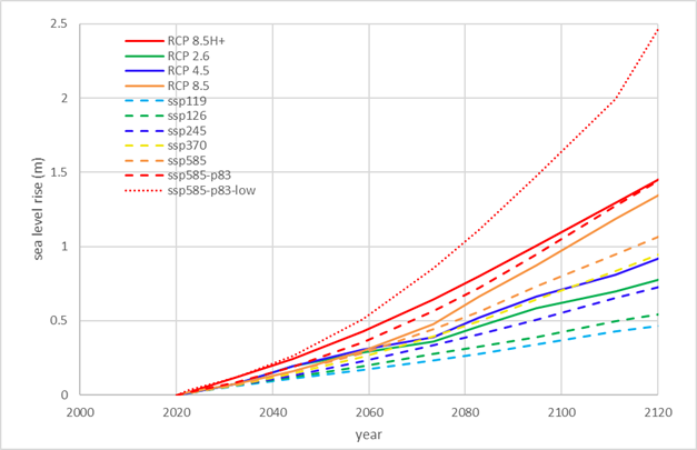
Figure 1: Comparison
between older sea level rise used for the concept design (IPPC AR5 adapted for
New Zealand in MFE guidelines for local government +2 mm/y subsidence, solid lines)
and the new data (dashed lines). Similar colours indicate comparable old versus
new scenarios. Dotted red line shows low confidence (representative of
potential impact of deeply uncertain ice sheet processes) AR6 SSP5 p83
99. The information available
at a regional scale is in at least 2 web platforms:
99.1. NASA sea level projection
tool (https://sealevel.nasa.gov/ipcc-ar6-sea-level-projection-tool)
99.2. TAKIWA sea level rise (https://searise.takiwa.co/, Under development by NZ
SeaRise, https://www.searise.nz/ )
100. These latest projections
include much more detail than what was used for the short-term concept design
(obtained from the MFE 2017, guidance for local government), as these were
nationwide and not region or site specific. The new AR6 data considers the new
SSP scenarios and local land vertical movement.
101. A comparison made using the
data in the NASA tool for the data point available for Hawke’s Bay (Figure
2), shows that the sea level rise considered in the development of concept
design is conservative with respect to the new data. This is because the
concept design included a 2 mm/y subsidence rate, added to the MFE (2017) sea
level rise data in contrast to the much lower rate considered in the new data
from the NASA tool which is 0.56mm/y.
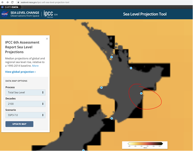
Figure 2: Location
of point available for Hawke’s Bay in the NASA sea level projection tool.
102. Larger vertical land
movements at a much higher spatial resolution, are indicated in the TAKIWA sea
level rise tool where values north of Awatoto are larger than the 2 mm/y design
consideration, reaching a maximum of 4.7mm/y in Westshore and Bayview (Figure
3). The impact of this increase over 20 years is 5.4 cm of additional sea
level rise by 2040. While this is not large and will not compromise the
effectiveness of the short-term design, this is a concern for the longer time
horizon.
103. Changes in storm surge and
wave climate have still not been assessed (or at least made public) at a
regional scale for the new AR6 data.
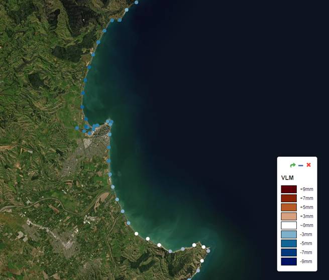
Figure 3: Vertical
land motion in Clifton to Tangoio from the TAKIWA Sea level rise tool.
104. The short-term design
concepts developed for the Strategy to date consider a conservative sea level
rise (0.24 m by year 2040) based on the RCP 8.5H+ data in MFE guidelines for
local government (2017). This level was used for the following reasons:
104.1. Consideration for the
likelihood that future science may indicate more pessimistic predictions.
104.2. Allowance for a longer
lifetime if the sea level rise in the next 20 years is lower than this
consideration. This provides a high degree of confidence that the designs
will be effective for the duration of the short-term time horizon (until 2040)
even if sea level rise is in the high range of the predictions.
104.3. The magnitude of the sea
level rise is still relatively small for the short term, even for the more
pessimistic scenario recommended for stress testing by the MFE (2017) guidance
for local government. Allowing this sea level rise as conservative assumption did
not significantly increase the cost of the short-term design.
104.4. Likelihood of the
implementation of the strategy getting delayed and the short-term time horizon
being postponed beyond 2040. The consideration will provide an allowance for
this design to be still effective for a lifetime beyond 2040, in the most
likely scenario that the sea level rise does not follow the considered carbon
emissions scenario.
105. The recent AR6 data shows
that the sea level rise predictions are similar with the design sea level being
slightly more conservative. However, the newly included SSP5 8.5 p83 low
confidence scenario indicates a higher increase (55 mm greater than the design
level). This is not a huge value so it’s likely that the design will
still be effective by 2040 if this scenario becomes the future reality.
Nevertheless, the adaptation of the design may be required earlier in this
case.
Clarify
dynamic adaptive planning approach – designed to accommodate constantly
changing knowledge and modelled future outcomes
106. Councils are required (by
the New Zealand Coastal Policy Statement 2010) to plan for coastal hazards and
the effects of sea level rise at least 100 years into the future.
107. A key challenge with this
timeframe is the high degree of uncertainty; the further ahead we try to plan,
the less certain things become, and there will be a continually evolving
landscape of new knowledge and new information.
108. The dynamic adaptive
planning approach adopted by the Strategy (from 2017 MfE guidance) is a direct
response to these challenges.
109. In simplified terms, the
following summarises a dynamic adaptive planning approach for sea level rise
and coastal hazards:
109.1. Determine what you want to
achieve (objectives)
109.2. Work out what hazard effects
you want to avoid (adaptation thresholds)
109.3. Decide what the options are
to respond to hazards risks
109.4. Compare, test, select
preferred option(s)
109.5. Act based on what you know
now
109.6. Remain flexible for what
you don’t know
109.7. Monitor: Signals –
triggers – thresholds
109.8. Revisit and adjust your
options / response as conditions change (act before threshold reached).
110. The pathways developed by
the Strategy have been established to allow flexibility into the future. The timing
between actions being implemented (short / medium / long) and the actions
themselves, will (and must) be adjusted overtime in response to real world
conditions.
Summarise
stress testing work undertaken by HBRC to date to test designs against different
IPCC scenarios (note: this is qualitative only at this stage, further
investment required to make it quantitative and benefit assessment required at
TAG to determine future course).
111. The stress testing work
undertaken to date contains the long-term adaptation strategy summarised in Table
14.
112. It also includes a simple
quantitative analysis showing the potential change in the adaptation timeframes,
which may be required under different greenhouse emissions scenarios including
the RCP 8.5 H+ scenario recommended for this purpose in the MFE (2017) guidance
for local government. It does not indicate the cost nor design details of the
adaptation required in each case.
Table 14 Summary
of long-term adaptation measures for the structures and measures considered in
the concept design for coastal units with current short-term preferred pathway
action.
|
Unit
|
Short-term structure/ measure
|
Long-term adaptation strategy
|
|
Clifton
|
Revetment
|
Strengthen design (increase hight, rock size, and toe depth,
decrease slope, add berm). Managed retreat is long-term preferred pathway and
may be implemented when cost becomes prohibitive.
|
|
Te Awanga -Haumoana
|
Groynes
|
Strengthen design (increase length, crest height, rock size,
decrease slope batters, add berm, add intermediate groynes). For Haumoana,
Managed retreat is long-term preferred pathway and may be implemented when
cost becomes prohibitive.
|
|
Nourishment
|
Modify nourishment rates and location. For Haumoana,
Managed retreat is long-term preferred pathway and may be implemented when
cost becomes prohibitive
|
|
Gravel barrier
|
Increase crest height and width. Higher maintenance may be
required. For Haumoana, Managed retreat is long-term preferred pathway
and may be implemented when cost becomes prohibitive
|
|
Westshore, Bay view, Whirinaki
|
Nourishment
|
Modify nourishment rates and location, include control
structures as per mid-term preferred pathway. Managed retreat is still a
possibility although has not been included as a preferred long-term pathway
in this first cycle of the Coastal Strategy.
|
Topic
8: An assessment of the carbon footprint arising from implementing the strategy
Present
work already undertaken by HBRC to build in carbon offsetting to cost estimates
113. The carbon footprint for
implementing the pathways as currently proposed has been considered in terms of
costs to offset emissions.
114. The short-term (first
action in proposed pathways) concept designs consider rough order costing for
the operational and capital carbon emissions offsetting. These costs are
included in the cost estimates outlined under Topic 6 above.
115. These costings are based on
the price for New Zealand emission units (at the time of the design report)
from the New Zealand Carbon Trading Emissions Scheme. The proportion of this
cost with respect of the total project cost is very minor (around 0.16% of the
construction cost for most alternatives and between 0.2% and 0.4% of the
maintenance cost).
116. Since the design report was
written in 2020, the price for New Zealand emission units has risen
considerably, from the value of $25 used in the design report, to a spot price
of $85 per unit in February 2022 (Figure 4)
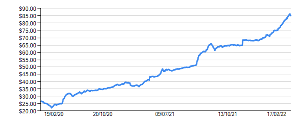
Figure 4: Cost of carbon emissions NZ trading scheme
(Commtrade, 2022).
117. While these prices will
continue to fluctuate, for comparison purposes this would increase the total
estimated carbon offsetting amount (across all short-term actions in the
pathways) from $25,000 to $85,000 in capital cost and from $6,100/y to
$20,740/y in operational costs.
Decision Making Process
118. Staff have assessed the
requirements of the Local Government Act 2002 in relation to this item and have
concluded that, as this report is for information only, the decision-making
provisions do not apply.
Recommendation
That Hawke’s Bay Regional
Council receives and notes the “HBRC Internal Review – Coastal
Hazards Strategy Implementation” staff report.
Authored by:
|
Simon Bendall
Coastal
Hazards Strategy
Project Manager
|
Jessica Ellerm
Group
Manager Corporate Services
|
Approved by:
|
Chris Dolley
Group
Manager Asset Management
|
|
Attachment/s
|
1⇩
|
Summary Table: Regulatory Workstream
reports by Mitchell Daysh Limited, 2020
|
|
|
|
2⇩
|
Snapshot of key Tāngata Whenua
interests and entities in the Strategy area
|
|
|