Meeting of the Environment and Integrated Catchments
Committee
Date: 10 November 2021
Time: 9.00am
|
Venue:
|
Council Chamber
Hawke's Bay Regional Council
159 Dalton Street
NAPIER
|
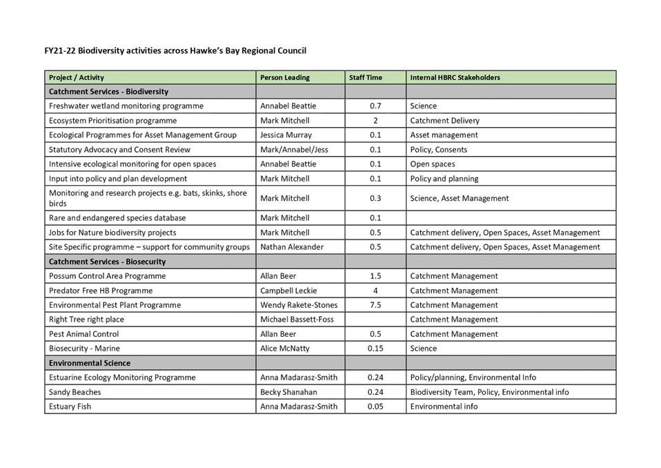
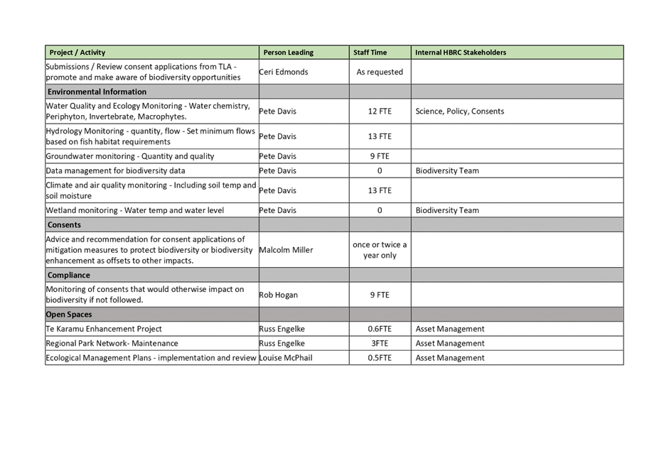
Agenda
Item Title Page
1. Welcome/Notices/Apologies
2. Conflict
of Interest Declarations
3. Confirmation of Minutes of the Environment and Integrated Catchments
Committee meeting held on 8 September 2021
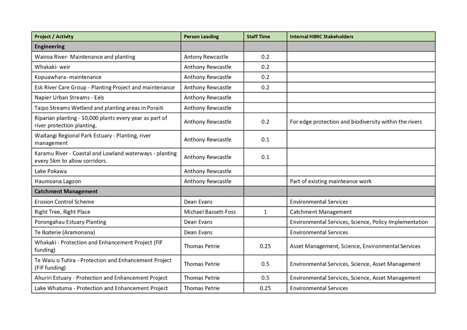
4. Follow-ups from
Previous Environment and Integrated Catchments Committee Meetings 3
5. Call for Minor
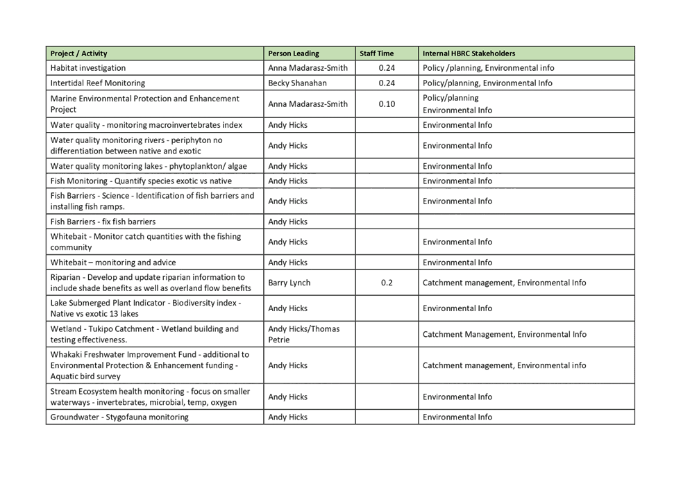
Items Not on the Agenda 7
Information or Performance
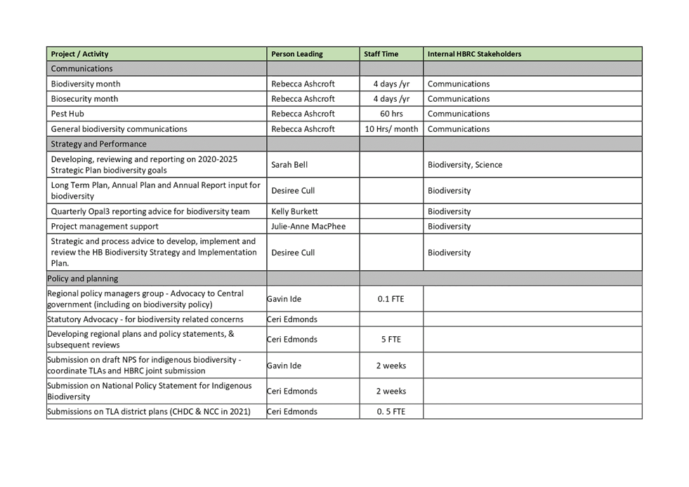
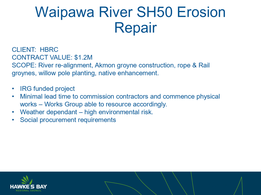
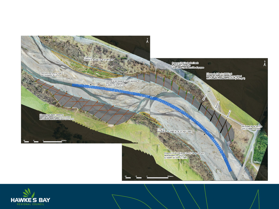
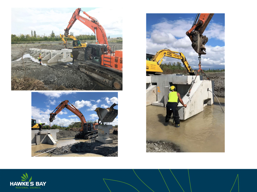
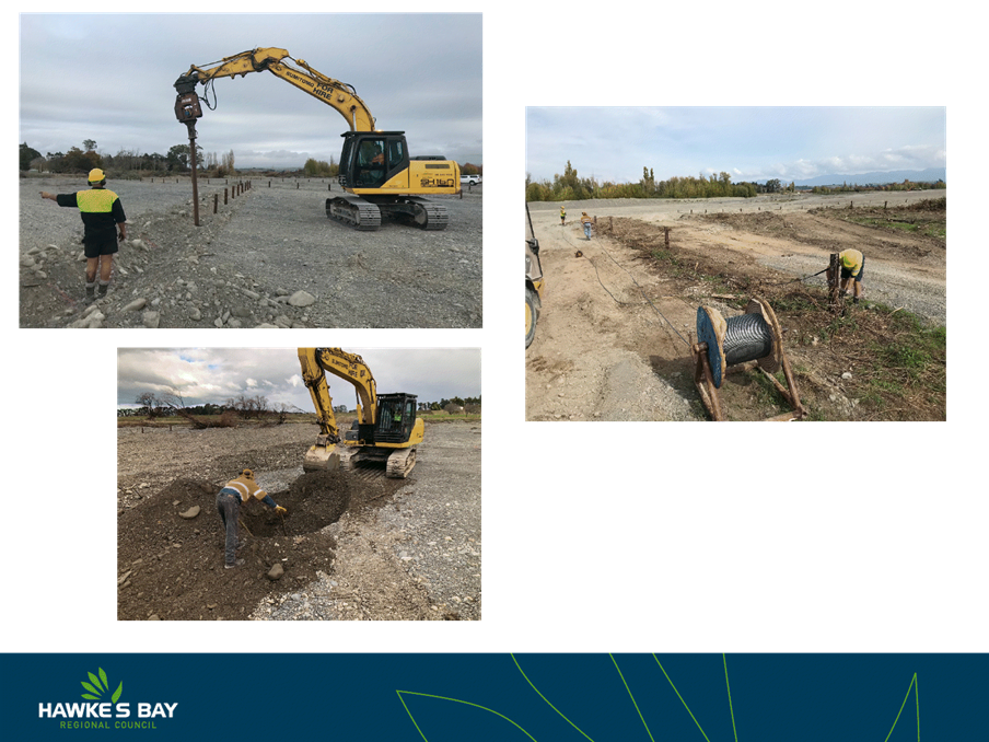
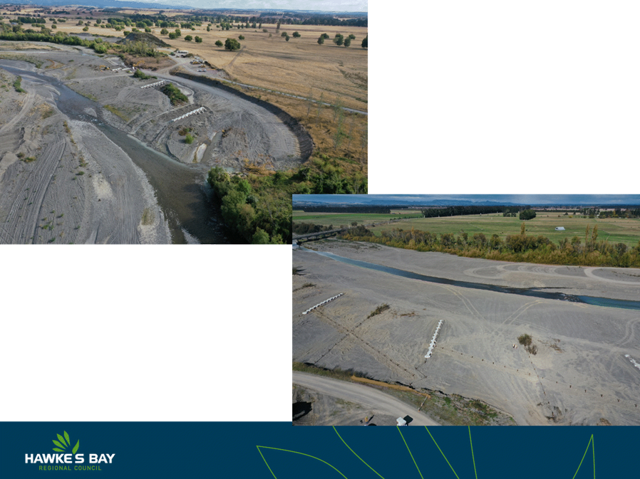
Monitoring
6. Future Farming
Trust 2020-21 Annual Report 9
7. Biodiversity -
Achieving Our Biodiversity Outcomes 21
8. Erosion Control -
The Big Picture for Our Region 35
9. Tukipo Wetland 45
10. Update on IRG Flood Control
Resilience Funded Projects 49
11. Works Group 2020-21
Performance Update 55
12. Chilean Needle Grass Control
Programme Review Update 91
13. Youth Environment Council
Update 127
14. Social Ecology Technical
Report from Edgar Burns, Waikato University Professorial Chair 129
15. Discussion of Minor Items not
on the Agenda 131
HAWKE’S BAY REGIONAL COUNCIL
Environment
and Integrated Catchments Committee
10 November 2021
Subject: Follow-ups from
Previous Environment and Integrated Catchments Committee Meetings
Reason
for Report
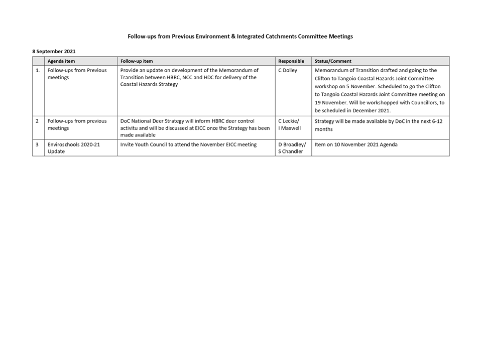
1. On the list attached are items raised at previous Environment and
Integrated Catchments Committee meetings that staff have followed up on. All
items indicate who is responsible for follow up, and a brief status comment.
Once the items have been reported to the Committee they will be removed from
the list.
Decision Making Process
2. Staff have assessed the requirements of the Local Government Act
2002 in relation to this item and have concluded that, as this report is for
information only, the decision-making provisions do not apply.
Recommendation
That the Environment and Integrated Catchments Committee
receives and notes the “Follow-ups from Previous Meetings”.
Authored by:
|
Leeanne
Hooper
Team Leader Governance
|
|
Approved by:
|
Chris Dolley
Group Manager
Asset Management
|
Iain Maxwell
Group Manager Integrated Catchment
Management
|
Attachment/s
|
1⇩
|
Followups for
November 2021 EICC mtg
|
|
|
|
Followups
for November 2021 EICC mtg
|
Attachment 1
|
HAWKE’S BAY REGIONAL
COUNCIL
Environment
and Integrated Catchments Committee
10 November 2021
Subject: Call for Minor Items
Not on the Agenda
Reason for Report
1. This item provides the means for committee members to raise minor
matters relating to the
general business of the meeting they wish to bring
to the attention of the meeting.
2. Hawke’s Bay Regional Council standing order 9.13 states:
2.1. “A meeting may discuss an item that is not on the agenda only if it
is a minor matter relating to the general business of the meeting and the
Chairperson explains at the beginning of the public part of the meeting that
the item will be discussed. However, the meeting may not make a resolution,
decision or recommendation about the item, except to refer it to a subsequent
meeting for further discussion.”
Recommendations
That the Environment and Integrated Catchments Committee accepts the
following “Minor Items
Not on the Agenda” for discussion as Item 15.
|
Leeanne Hooper
GOVERNANCE TEAM LEADER
|
James Palmer
CHIEF EXECUTIVE
|
HAWKE’S BAY REGIONAL COUNCIL
Environment
and Integrated Catchments Committee
10 November 2021
Subject: Future Farming Trust
2020-21 Annual Report
Reason for Report
1. This item introduces the Future Farming Trust 2020-21 Annual Report (attached) and presentation
by the Trust Board.
Decision Making
Process
2. Staff have assessed the requirements of the Local Government Act
2002 in relation to this item and have concluded that, as this report is for
information only, the decision making provisions do not apply.
Recommendation
That the Environment and Integrated
Catchments Committee receives and notes the HB Future
Farming Trust 2020-21 Annual Report and
presentation.
Authored by:
|
Leeanne
Hooper
Team Leader Governance
|
|
Approved by:
|
James Palmer
Chief Executive
|
|
Attachment/s
|
1⇩
|
HB Future
Farming Trust Annual Report 2020-21
|
|
|
|
2⇩
|
HB Future
Farming Trust Financials 2021
|
|
|
|
HB
Future Farming Trust Annual Report 2020-21
|
Attachment 1
|
|
HB Future Farming Trust Financials
2021
|
Attachment 2
|
HAWKE’S BAY REGIONAL COUNCIL
Environment
and Integrated Catchments Committee
10 November 2021
Subject: Biodiversity -
Achieving Our Biodiversity Outcomes
Reason for Report
1. This item provides an overview of cross Council investment in biodiversity-related
programmes and upcoming challenges in the biodiversity space that will
potentially require resourcing through the 2024-34 Long Term Plan.
Executive
Summary
2. The Global Biodiversity Crisis - The
world is witnessing a large-scale degradation of nature, resulting in an
unprecedented loss of species. Current global biodiversity trends indicate a
rapid loss of both the area and the quality of natural ecosystems. The recent
rapid loss of biodiversity suggests the planet is witnessing its sixth mass
extinction wave, which is human-induced. Despite an increase globally in
policies and actions to support biodiversity, biodiversity loss has worsened.
On the current trajectory, it is predicted that approximately half of all
species are at risk of extinction by the end of the century.
3. New Zealand is listed as the worst country in the world for many
threatened species. More than 4000 species are currently threatened or at risk
of extinction. The drivers behind biodiversity loss are multiple and complex of
which no one entity can solve alone.
4. The Regional Council has a range of programmes that help protect or
enhance our environment; however, most of these are focused on water quality.
Few are aimed at addressing terrestrial or marine biodiversity decline. This
item outlines those programmes that help protect and enhance biodiversity and
the internal collaboration in delivering them.
Strategic Fit
5. Biodiversity is one of the four priority focus areas in the
2020-2025 Strategic Plan: Healthy, functioning and climate-resilient
biodiversity. Kia ora, kia āhei, kia mārohirohi ā-āhuarangi
hoki te rerenga rauropi.
6. There are four strategic goals.
6.1. By 2020, regional priority locations for ecosystem restoration -
including in the coastal marine area - have been identified.
6.2. By 2030, key species and habitat (sites) are prioritised and under
active restoration. Source:
HB Biodiversity Strategy, 2015-2050 and Action Plan 2017-2020
6.3. By 2050, a full range of indigenous habitats and ecosystems, and
abundance and distributions of taonga species are maintained and increased in
every catchment in Hawke's Bay. Source: HB Biodiversity Strategy, 2015-2050 and Action Plan 2017-2020
6.4. By 2050, Hawke's Bay is predator free in line with NZ 2050 target. Source: PF2050
7. Climate change also impacts biodiversity. With many of our lowland
ecosystems reduced to small, fragmented remnants with poor connectivity, they,
and the species that live within them, are particularly vulnerable to the
effects of climate change such as drought, fire, heavy rainfall and sea level
rise.
8. Other plans that feed into Council’s biodiversity programmes
are Hawke's Bay Biodiversity Strategy, Hawke's Bay Regional Pest Management
Plan and the Asset Management Ecological Management and Enhancement Plan.
9. The Te Mana o te Taiao - Aotearoa New Zealand Biodiversity Strategy
2020 was launched in August 2020. An implementation plan for this strategy is
currently being drafted, which the regional sector is feeding into. The
National Policy Statement for Indigenous Biodiversity is due to go to cabinet
mid-2022. Kotahi will see the Regional Policy Statement
and Plan updated to give effect to the NPSIB and NPSFM. It will do this by
including objectives, policies and rules which protect wetlands, give effect to
Te Mana o te Wai, enable restoration projects and implementation of the
Hawke’s Bay Biodiversity Strategy, and require territorial authorities to
identify and protect SNAs.
Background
10. Indigenous
biodiversity in New Zealand is in crisis. Around 4000 species are currently
threatened or at risk of extinction. Many species continue to decline or are
just hanging on. This includes biodiversity in the Hawke's Bay region, which
has lost 77% of the original indigenous forest that once covered the region. Half
the remaining forest types are categorised as threatened, with the greatest
losses being lowland forest types.
11. The
causes of biodiversity loss are multiple and complex. This loss is driven by
pressures such as invasive species, land and sea use, direct exploitation of
species, climate change, and pollution. Equally, not having suitable systems in
place in terms of policy, legislation and leadership, not having enough
knowledge or resources to act, and a disconnect between people and nature
contribute to these direct pressures.
12. As shown
in attachment one, the council has a range of programmes that help protect and
enhance biodiversity. The success of these programmes is dependent on good
internal communication and collaboration.
13. The
following is an outline of some of these programmes.
14. Ecosystem
Prioritisation programme – The focus of this
programme is to secure remaining high biodiversity remnants in Hawke's Bay from
extinction. The main works undertaken are deer fencing, pest plant and animal
control and planting. It involves working closely with a large number of
external agencies and stakeholders, such as QEII Trust, the rural sector and
land occupiers.
15. Possum
Control Area programme – This programme has
arguably had the most significant biodiversity gains in Hawke's Bay. Although
no formal monitoring was undertaken, there are a number of examples of native
species, such as long tailed bats, whiteheads and numerous plant species,
increasing, or recolonising areas post possum control. This programme currently
relies on land occupiers to undertake control.
16. Site
specific pests – This programme primarily
supports land occupiers and community groups in undertaking pest control at
sites of high biodiversity value through the provision of traps, engaging
contractors and providing technical support.
17. Predator
Free programme – There is currently 40,000ha in sustained mustelid control in Cape
to City and Poutiri Ao o Tane. In addition, there is 14,500 ha, with possum
eradication being undertaken on the Mahia peninsula. Predator control (possums,
stoats, ferrets, weasels and feral cats) is a critical component in
biodiversity recovery and was outlined in the parliamentary commissioner for
the environments report "Taonga of an island nation: saving New Zealand
birds" as one of the top three interventions for biodiversity recovery in
New Zealand. The Predator Free programme is one of HBRC’s strategic
goals. It will be a key initiative that directly drives biodiversity outcomes
and enhances other HBRC and community investments into biodiversity.
18. Environmental
pest plant programmes – A range of
environmental plants, such as old man's beard, Japanese honeysuckle, wilding
pines and Darwin's Barberry, are managed either at specified sites or
region-wide to minimise their impacts on indigenous areas.
19. Erosion
Control Scheme – The purpose of this scheme
is to enable tree planting and other erosion control work to occur on those
areas of land that are not for commercial planting purposes. The Erosion
Control Scheme aims to reduce soil erosion, improve water quality, improve
terrestrial and aquatic biodiversity through habitat protection and creation
and provide community and cultural benefits through forest ecosystem services.
20. Environmental
Protection and Enhancement Programme – The purpose of this fund is to provide accelerated on-ground action
across five priority areas identified throughout the region – Ahuriri
Estuary, Lake Tūtira, Lake Whakakī, Lake Whatumā and our Marine
environment. A key focus of this work is to partner with the community and
stakeholders to deliver high-value environmental outcomes on a catchment scale
such as improved water quality, riparian protection, biodiversity enhancement,
wetland development/ protection.
21. Open Spaces – Protect and enhance
biodiversity throughout the Regional Park network by working with the
community, tangata whenua, businesses and schools to undertake restoration
plantings and predator and pest plant control. The Regional Park network is
collectively over 1000 hectares (alongside 1200 hectares of forestry) and has
several areas of high biodiversity value such as Pekapeka Regional Park
wetlands, Tūtira Regional Park, Whittle Reserve and Waitangi Regional
Park. The Open Spaces team supports restoration activities such as areas of the
Karamu and Napier streams, which create important corridors to enhance urban
biodiversity, or wetland creation and protection, helping create habitat for
precious taonga such as tuna and inanga. Predator control programmes to protect
endangered species such as Bittern, Black billed gull, and New Zealand
dotterel, are undertaken by the community with support from the Catchment
Services section.
22. Environmental
Science – A variety of water quality and
ecology monitoring programmes are undertaken across the region. This monitoring
includes direct measurements of biodiversity (e.g. macroinvertebrate counts in
rivers and phytoplankton counts in lakes) but mainly focuses on habitat quality
and instream conditions supporting biodiversity. Reporting is focused on
ecosystem health type metrics rather than specific biodiversity metrics.
22.1. The
science team is also building its understanding of key environmental and
ecological relationships that support the region's coastal resources. This
includes the biodiversity that supports ecosystem services and functions,
monitoring to determine the state of these resources, and how our activities
may be impacting them. This knowledge supports decisions that improve the state
of our natural resources so that they can function for generations to come and
includes looking at the animals and plants that inhabit these environments.
23. Asset
Management – has a range of programmes that
seek to protect and increase the biodiversity values of flood protection assets
(river, drainage). An example of this is the implementation work jointly
undertaken with the Biodiversity Team to deliver the Ecological Management and
Enhancement Plan, which includes shorebird surveys and the protection of high
biodiversity remnants along the lower reaches of the Ngaruroro River. Another
example is the biodiversity enhancement work undertaken as part of the stopbank
upgrade project. The asset management group see this biodiversity work
increasing and will require continued expertise within the regional council.
24. Policy - key policy mechanisms advocate for preserving and enhancing
indigenous flora and fauna through statutory advocacy and strengthening
regulatory settings through Kotahi. In addition to the National Policy Statement
for Freshwater 2020 (NPSFM), which requires us to give effect to Te Mana o Te
Wai and protect and restore wetlands, a National Policy Statement for
Indigenous Biodiversity (NPSIB) is intended for release during this term of
government. The main goal of the draft NPSIB was to maintain indigenous
biodiversity through more consistent identification and protection of
Significant Natural Areas (SNAs) by city and district councils.
24.1. Kotahi
will see the Regional Policy Statement and Plan updated to give effect to the
NPSIB and NPSFM. It will do this by including objectives, policies and rules
which protect wetlands, give effect to Te Mana o te Wai, enable restoration
projects and implementation of the Hawkes Bay Biodiversity Strategy, and
require territorial authorities to identify and protect SNAs.
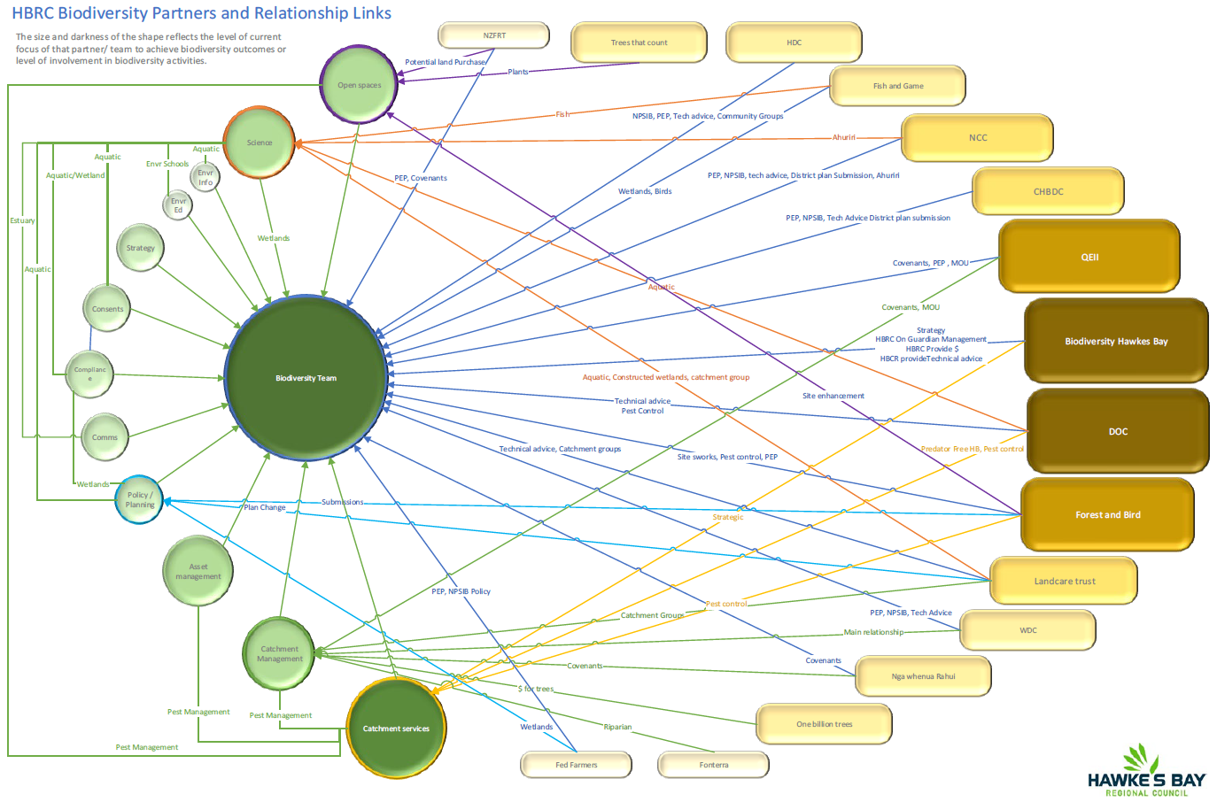
25. As shown
in attachment two, Council also works with a large number of external agencies
and stakeholders in delivering biodiversity programmes, such as the Department
of Conservation, QEII Trust, Biodiversity Hawke's Bay, Forest and Bird, New
Zealand Landcare Trust, Nga Whenua Rahui, Local Authorities, the rural sector,
community groups and land occupiers.
Discussion
26. Council has a range of environmental
programmes that help protect and enhance biodiversity, and teams within council
collaborate well both internally and externally in delivering these. However,
staff acknowledge they are not fully streamlined or at the scale required to
halt biodiversity decline in Hawke's Bay. Like climate change, Biodiversity
sits across multiple sections within Council. To maximise Council‘s
investment in biodiversity, an internally facing biodiversity operational
strategy is required to better coordinate these programmes and enhance their
impact. Staff are early in the process towards the development of such a
strategy.
27. Furthermore Council currently does not have
a biodiversity monitoring programme in place therefore consistent, comprehensive
information about biodiversity across the Hawke’s Bay region is not
available. Without this information it is not possible to assess the impact our
programmes may be having nor the progress we may be making in halting
biodiversity decline.
28. Staff recently explored options for
undertaking biodiversity outcome monitoring that could be implemented in
Hawke’s Bay. Unfortunately, there is currently no consistent national
approach in biodiversity outcome monitoring. HBRC staff, in partnership with the
national Biodiversity Working Group, have led a Tier 2 Biodiversity Outcome
Monitoring Programme review with the aim of generating consistency in how the
Regional Sector monitor biodiversity. This programme is being piloted by a
number of regional councils this summer and will likely undergo further
refinement. The intent is to create a nationally consistent biodiversity
outcome monitoring programme that can then be operationalised in Hawke’s
Bay to produce meaningful information on regional biodiversity trends that can
also be aggregated up and compared at a national level.
29. Further to this, the National Policy Statement for Indigenous
Biodiversity is intended for release during this term of government which may
require the Regional Council to:
29.1. Work
closely with Local Authorities in identifying, mapping and managing adverse
effects to Significant Natural Areas
29.2. Identifying
taonga species
29.3. Managing
risks to highly mobile fauna
29.4. Support
restoration and enhancement of SNAs
29.5. Amend
our current Regional Biodiversity Strategy
29.6. Implement a regional biodiversity monitoring programme.
30. It is difficult to prepare for and
accurately cost the likely resource implications of the NPS-IB for Council
until the policy statement is released but given the above components that may
affect council, it will likely require funding through the 2024-34 LTP.
31. As noted
above, biodiversity is one of the four priority focus areas in the 2020-2025
Strategic Plan. However, with current investment we are unlikely to meet our
2030 (key species and habitat (sites) are prioritised and under active
restoration) and 2050 (full range of indigenous habitats and ecosystems, and
abundance and distributions of taonga species are maintained and increased in
every catchment in Hawke's Bay) goals. As part of the development of an
internal biodiversity operational strategy, a close look at the strategic plan
goals and opportunities to fine tune existing programmes to assist in meeting
these goals is essential. Ultimately this may lead to a structural change
within Council.
Next Steps
32. There are
currently a series of drivers at play that will influence both the resources
and structure of Council’s investment in biodiversity. These include Aotearoa New Zealand Biodiversity Strategy 2020, the National
Policy Statement for Indigenous Biodiversity, Kotahi, the
development of a Biodiversity Outcome Monitoring Programme, the review of the
Possum Control Area programme, alongside community expectations.
33. Staff are
working on the following actions.
33.1. Development of an internal biodiversity operational strategy that
will allow us to better align work programmes across council to maximise the
return on investment in biodiversity and to assist with meeting the Strategic
Plan goals. It is acknowledged that the Strategic Plan goals are ambitious but
prior to requesting any further resources it is essential that existing
programmes are better aligned to enhance internal performance on biodiversity
investment first. This is partially underway with a review in progress of the
Ecosystem Prioritisation programme, as part of a wider grants policy review,
that is going to combine the Erosion Control scheme, Ecosystem Prioritisation
programme and the Environmental Protection and Enhancement Programme into one
document. This will be presented to EICC in early 2022.
33.2. Continue
to lead the development of a nationally consistent Tier 2 Biodiversity outcome
monitoring programme with the intent of submitting a proposal to the 2024-34
LTP for a region-specific biodiversity monitoring programme.
33.3. Assessing
the resource implications of the Aotearoa New Zealand
Biodiversity Strategy 2020 Implementation Plan and the National Policy
Statement for Indigenous Biodiversity (once released) with the intention of submitting a proposal to the 2024-34 LTP.
Decision Making
Process
34. Staff
have assessed the requirements of the Local Government Act 2002 in relation to
this item and have concluded that, as this report is for information only, the
decision making provisions do not apply.
Recommendation
That the Environment and Integrated
Catchments Committee receives and notes the “Biodiversity
- Achieving Our Biodiversity Outcomes” staff report.
Authored by:
|
Russell
Engelke
Team Leader Open Spaces
|
Dean Evans
Manager Catchments Delivery
|
|
Martina
Groves
Manager Regional Assets
|
Dr Andy Hicks
Team Leader/Principal Scientist Water
Quality and Ecology
|
|
Campbell
Leckie
Manager Catchment Services
|
Anna
Madarasz-Smith
Team Leader/Principal Scientist Marine &
Coast
|
|
Mark Mitchell
Team Leader Principal Advisor Biosecurity
Biodiversity
|
Dr Jeff Smith
Manager Science
|
|
Jolene
Townshend
Senior Advisor Integrated Catchment
Management
|
|
Approved by:
|
Chris Dolley
Group Manager Asset Management
|
Iain Maxwell
Group Manager Integrated Catchment
Management
|
Attachment/s
|
1⇩
|
Biodiversity
Activities Across Council
|
|
|
|
2⇩
|
Biodiversity
Team Internal and External Relationships
|
|
|
|
Biodiversity
Activities Across Council
|
Attachment 1
|
|
Biodiversity Team Internal
and External Relationships
|
Attachment 2
|
HAWKE’S BAY REGIONAL
COUNCIL
Environment
and Integrated Catchments Committee
10 November 2021
Subject: Erosion Control - The
Big Picture for Our RegioN
Reason for Report
1. This item provides the committee with an overview of cross-Council
programmes of work that are contributing to the identification, control and
monitoring of erosion across the Hawke’s Bay region.
Executive
Summary
2. Erosion control activity is integrally linked to priority focus
areas in the 2021-2025 Strategic Plan with a key strategic goal relating to
erosion mitigation “By 2050, all highly erodible land is under tree
cover”.
3. The significant challenges facing the region about the adverse
impacts of erosive processes and corresponding sedimentation (estimated at an
annual average of 5 million tonnes of soil loss across
the region) alongside its response to climate change
have been well traversed with Council.
4. Aside from regulatory processes such as Tukituki PC6,
Council’s preferred erosion control response is non-regulatory as this
enables relationship building and helps to ensure buy in from landowners.
5. As a result, Council has responded with a range of interlinked
non-regulatory initiatives:
5.1. In the parts of the region where Farm Environmental Management Plans
(FEMPs) are not regulated, and where landowners are being proactive in this
space, FEMPs focus on good management practices to reduce environmental impacts
on farms, including erosion mitigation.
5.2. Right Tree Right Place (RTRP), after four years of important
background work, Council has recently funded the RTRP project to pilot a
partial farm afforestation model to address the significant problem with the
most erodible land. It aims to provide evidence, education, tools and
confidence for the farming and investment sector to stimulate planting on the
marginal areas of pastoral farms.
5.3. The Erosion Control Scheme (ECS) enables targeted erosion control to
be delivered on highly erodible land through tree planting and other erosion control works on those
areas of land that are not suitable for commercial planting purposes.
5.4. Protection and Enhancement Programme (PEP) focusses on particular
catchments or at identified high value sites to implement environmental good
management practices on the ground.
5.5. Environmental Monitoring consists of an automated sediment
monitoring system to understand how the councils ECS is influencing erosion
rates and sediment loads across the region.
6. The degree to which these initiatives are interlinked has evolved over time through good science and learning. The
Catchment Delivery Team provides a pivotal relationship building function
within Council for the extensive farm sector initiatives underway across
Council. Examples of erosion control interlinked initiatives include:
6.1. Farm Environmental Management Plans (FEMPs)
enable a strategic and planned approach to addressing the erosion issues on
farms; understanding the full extent of the required work/initiatives, and what
resources (ECS, RTRP) would be needed over time to make it happen.
6.2. HBRC Environmental Monitoring programme will inform progress with
the erosion control initiatives and be used as a basis to further build
monitoring programmes for new initiatives such as RTRP outputs.
6.3. Erosion control activity enables Council to credibly partner with
Government to leverage funding support for initiatives like the Hill Country
Erosion Fund and RTRP.
Strategic Fit
7. Erosion control activities can be linked to three of the four
priority focus areas in the 2020-2025 Strategic Plan. The core focus area for
erosion is Climate-smart and sustainable land use but is also strongly linked
to:
7.1. Water quality, safety, and climate-resilience security
7.2. Healthy, functioning and climate-resilient biodiversity.
8. The key strategic goal (outcome measure) relating to erosion
mitigation is:
8.1. By 2050, all highly erodible land is under tree cover.
Background
9. Hawke’s Bay is prone to hill country erosion due to its soft
rock geology and large-scale land use change over many decades. To quantify the
extent of the erosion in the region the SedNetNZ model was used. SedNet
modelling estimates that approximately 252,000 ha of land yields over
1000t/km2/yr. This equates to approximately 5 million tonnes of sediment per
year entering our rivers and then into our estuaries. It is this area of land
that has been used as the basis for prioritising areas for action through the
council’s erosion control activities.
Discussion
10. The
Hawke’s Bay region is extremely prone to erosion. The Council has
invested in a great deal of resources in quantifying the scale of erosion in
the region and the SedNetNZ model has been the main tool in doing this.
11. The
SedNetNZ model is being used by HBRC to identify areas of erosion and quantify
the amount of erosion and sediment loss in tonnes per year across the region.
With the information supplied by this modelling we are able to plan where we
will prioritise our erosion mitigation efforts and by how much our mitigation
efforts will reduce erosion in the future. The majority of the 5 million tonnes
of soil/sediment loss per year across the region is coming from the northern
part of the region (approximately 5 million tonnes).
Data supplied by science, plans and tools have been developed to support
council address this issue.
12. Four of
the key issues when addressing erosion across the region are:
12.1. Most of
the erosion is on private land and permission is needed to access it.
12.2. Currently,
implementing erosion control actions is mostly voluntary.
12.3. Climate
change, weather extremes such as drought and the impact on erosion plantings.
12.4. Pest
and weed control destroying new plantings (e.g. deer and goats).
13. There are
two approaches available to council when highlighting and discussing erosion
issues with rural landowners:
13.1. Regulatory
approach (Tukituki PC6 – farm plans)
13.2. Non-regulatory
approach (one on one with landowners and engagement through catchment groups).
14. The non-regulatory
approach is the preferred option as this creates an enduring relationship with
the landowner and helps to ensure ongoing buy in.
15. The
significant challenges facing the region about the adverse impacts of erosive
processes and corresponding sedimentation alongside its response to climate
change have been well traversed with Council. Council has responded with a
range of interlinked initiatives (listed below) that have evolved over time
through good science and learning.
Farm Environmental Management Plans
(regulatory approach)
16. Farm
Environmental Management Plans (FEMPs) have been required in the Tukituki
region since 2018 for all properties over 4 ha, that do not meet the low
intensity criteria. FEMPs are required through the revised RMA 2020 (part 9A)
and regionally under the Tukituki PC6. In the near future, FEMPs will become
mandatory nationally under Fresh Water – Farm Plans (FW-FP) and
Integrated Farm Planning (IFP).
17. In 2018
several pathways were provided and tested for farmers to prepare a FEMP. They
could write the plan themselves, use an industry professional or attend a
workshop to complete their plans. This got the process underway and enabled the
initial completion of plans. To improve quality and consistency of Tukituki FEMPs,
an approved provider must write the plan and submit summary information to
Council. Tukituki FEMP providers give an outside view to farmers to help
identify erosion and other issues on their land. In the nationally
proposed FW-FPs, a certifier will have to sign off each plan as meeting the
required standards (to be determined). FEMPs should address specific time-bound
actions on property, focusing on good management practices and regulatory
requirements to reduce environmental impacts from the farming operation.
18. FEMPs
address erosion and erosion control by identifying and addressing Critical
Source Areas (CSAs) for erosion, with appropriate targeted actions. CSAs are
locations on a property where a source of pollution meets a transportation
method. Runoff from CSAs carries sediment and other nutrients into waterways.
In areas and catchments with erosion issues the FEMPs will identify and address
these.
19. Catchment
Advisors (C.A.) working in these target areas of high sediment loss will work
with the farmer to develop an erosion control plan as a prerequisite for
funding through the ECS. This is a plan which develops the detail of actions,
costs and materials required on specified parts of the property over the next
2-5 years. Where a farm plan exists, the C.A. will be able to pick up the
information in the plan to refine a more detailed agreement for action in the
short term.
20. FEMPs
have introduced a bottom-line requirement for everyone to be involved in
identifying environmental risks on-farm and committing to actions in a time
bound manner. Approximately 1000 properties in the Tukituki region meet either
low intensity or FEMP requirements.
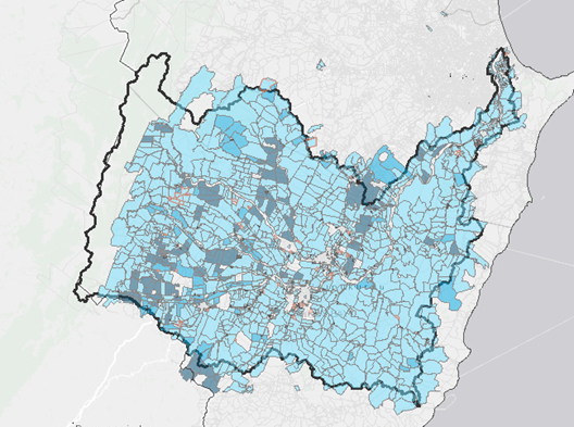
Figure 1: Coverage of FEMPs in 2018
submission cycle in the Tukituki
Right Tree, Right Place
21. In 2018, SedNet modelling identified 252,000ha of the
region has land eroding at more than 1000 tonnes/km2/yr. After more than a decade of experience
relating to forest planting and management, and exploring options about
potential with carbon farming, Council embarked on a two-year project investigating foundational research about diverse tree cover
as a principal tool to address this challenge. The project was jointly funded
by HBRC and TUR/1BT.
22. Based on
this work, a RTRP project has been planned to pilot a partial farm
afforestation model to address the significant problem with the most erodible
and least productive land. Fundamentally, it aims to provide evidence,
education, tools and confidence for the farming and investment sector to
stimulate planting on the marginal areas of pastoral farms.
23. The RTRP
project builds on the experience within the Catchment Delivery Team, offering
another solution for erosion control alongside the ECS and related activity.
Further, the FEMP framework will increasingly become an input into
prioritisation and planting regimes required on-farm, and the HBRC
Environmental Monitoring programme will inform progress and be used as a basis
to build a monitoring programme for RTRP outputs.
24. Through a
partnership with The Nature Conservancy, due diligence will be completed on the
opportunity to scale the RTRP model through a market driven impact investment
framework.
25. Initial
pilot farms have been identified to undergo a pilot farm selection process
before having farm/forestry plans completed and potential funding partnership
for tree planting.
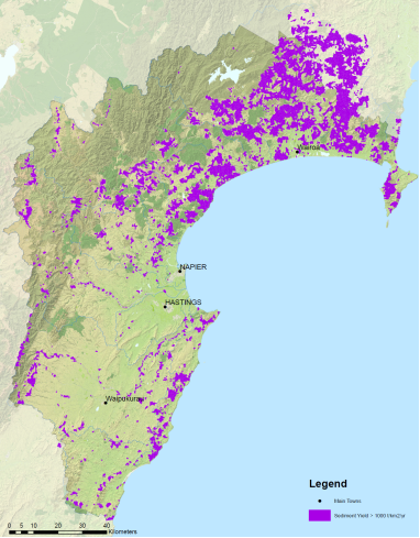
Figure 2: Sediment Yield >1000t/km2/yr
in Hawke’s Bay
26. There is expected to be around 10,000 ha of the
highest risk land planted over the next ten years by grant funding initiatives
directly supported by Council such as through Council’s investment of
$30M in the Erosion Control Scheme. However, the scale of the regional context
represents significant challenges, risks and opportunities, which the RTRP
pilot is aimed to address.
27. After considering a Business Case and public consultation
through the 2021-31 Long Term Plan process, Council agreed to fund $4.8M toward
the pilot of the RTRP concept.
Erosion Control Scheme (ECS)
28. In 2018,
Council established the Erosion Control Scheme. Its purpose is to enable
tree planting and other erosion control work to occur on highly erodible land
and enables this by providing significant financial support for these erosion
control works.
29. The ECS enables targeted erosion control to be delivered on
highly erodible land where other initiatives are not deemed appropriate e.g.
RTRP, this work is agreed to in partnership with landowners. The ECS is a
key tool for the Catchment Delivery Team to engage with and support landholders
with land at high risk of erosion. The 2018 - 2028 LTP provided for
$30 million over the 10-year term of the LTP to support this programme of
work.
30. This scheme enables tree planting and other
erosion control works to occur on those areas of land that are not suitable for
commercial planting purposes. Examples of such land includes (but is not
limited to) remote locations, infertile soil types, smaller erosion prone
areas, and areas where commercial tree planting is inappropriate. Within
such areas, the Erosion Control Scheme aims to:
30.1. Reduce
soil erosion
30.2. Improve
water quality through the reduction of sedimentation into waterways
30.3. Improve
terrestrial and aquatic biodiversity through habitat protection and creation
31. The introduction of FEMPs in the Tukituki
through PC6 had the potential to enable a strategic and planned approach to
addressing the erosion issues on those farms; understanding the full extent of
the required works, and what resources would be needed over time to make it
happen. Unfortunately, because the actions within the FEMPs are held by the
landowner and not the council, this information is not available unless each
individual landowner provides it. Information that is gathered through the
consenting process will be used for FEMP auditing purposes in the future.
32. Discussions with the Policy Implementation team
have begun to ensure the non-regulatory approach of the ECS, and other
Catchment Delivery work streams are aligned and integrated to the best extent
possible, for the regional introduction of FEMPs in the future.
33. Catchment
Delivery staff through their work with farmers, are some of the key
relationship builders within Council, and these relationships help enable
improved and more efficient access to these farms for council staff from other
sections. These relationships are key to Catchment Delivery staff being able to
identify opportunities, provide advice, and make key connections to the
councils RTRP programme.
34. The Hill
Country Erosion Fund (approx. $5m over 4 years) is central government funding
(MPI) that was applied for and secured to financially support the
implementation of the councils Erosion Control Scheme. Examples of targeted
support include: the funding of 4 staff, providing a range of events to educate
and train staff and external groups to help facilitate erosion control actions,
and works on the ground, including the space planting of poplar and willow and
assisted reversion. This fund has also provided for a monitoring programme
using ISCO sediment monitors (see Fig:3). These monitors record the change in
sediment load over time in catchments where erosion control has taken place.
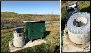
Figure 3: Automated sediment sampler (ISCO)
Protection and Enhancement Programme
(PEP)
35. Formally
the ‘Hot Spots’ programme, the Protection and Enhancement Programme
focusses on particular catchments or at identified high value sites to
implement environmental good management practices on the ground. This programme
works alongside and in collaboration with Catchment Delivery staff, local
communities, and key stakeholders to achieve agreed outcomes. Because of the
natural alignment with the ECS when working in areas of highly erodible land,
outputs from this programme also have a key part to play in meeting councils
LOS for erosion and ensuring regional coverage.
Environmental Monitoring
36. To
monitor how the councils Erosion Control Scheme (ECS) is influencing erosion
rates and sediment loads across Hawke’s Bay, an automated sediment
monitoring system has been set up. This network (see Fig 4 attached) of 20
automated sediment samplers (called ISCOs) is programmed to only take samples
at high flows. It is estimated that 90% of total sediment is transported during
these high flows and is something we haven’t regularly monitored before.
The ISCOs have been strategically located in areas that will have major tree
planting carried out up stream allowing the ISCO to detect any reduction in
sediment because of these plantings. This is a long-term monitoring programme
with the effects of the ECS not expected to show a reduction in sediment for
10-20 years as the new plantings mature. However, the effects of other erosion
mitigation measures such as riparian planting and/or increased riparian fencing
/ stock exclusion may show up much earlier in the monitoring.
37. Data is
already being collected from the ISCO network and our oldest site at Red Bridge
on the lower reaches of the Tukituki River (established in 2018) has already
shown the large amounts of sediment that can be mobilised during a brief
intense storm event. During a high flow event over a 3 day period in 2018 the
ISCO sampling showed that nearly 400,000 tonnes of sediment moved past the Red
Bridge site. As erosion mitigation measures are put in place including tree
plantings through the ECS, we should see a decline in these loads over time.
Next Steps
38. Longer
term we will need to consider what targeted erosion control programmes/tools
follow once the ECS and RTRP have run their course and funding has ended.
39. To fully
understand the impacts and opportunities of Farm Planning regulations on the
ability to deliver effective and timely erosion control.
40. To fully
understand and then plan for the future capacity and capability needs for council
to deliver on their long-term strategic goals, and meeting annual levels of
service measures for erosion control.
41. To ensure
manageable leveraged external funding is sourced to support regional erosion
control e.g. HCEF.
42. To ensure
maximum value is added for landowners and the regions ratepayers when catchment
delivery staff are on site providing advice and partnering with landowners.
Decision Making
Process
43. Staff
have assessed the requirements of the Local Government Act 2002 in relation to this
item and have concluded that, as this report is for information only, the
decision making provisions do not apply.
Recommendation
That the Environment and Integrated
Catchments Committee receives and notes the “Erosion Control - The Big
Picture for Our Region” staff report.
Authored by:
|
Michael
Bassett-Foss
RTRP Project Manager
|
Dean Evans
Manager Catchments Delivery
|
|
Dr Barry
Lynch
Team Leader/Principal Scientist (Land
Science)
|
Marnie
Mannering
FEMP Project Manager
|
|
Brendan
Powell
Manager Catchments Policy Implementation
|
Dr Jeff Smith
Manager Science
|
Approved by:
|
Iain Maxwell
Group Manager Integrated Catchment
Management
|
|
Attachment/s
|
1⇩
|
Figure 4:
Automated ISCO sampling locations across Hawke’s Bay
|
|
|
|
Figure
4: Automated ISCO sampling locations across Hawke’s Bay
|
Attachment 1
|
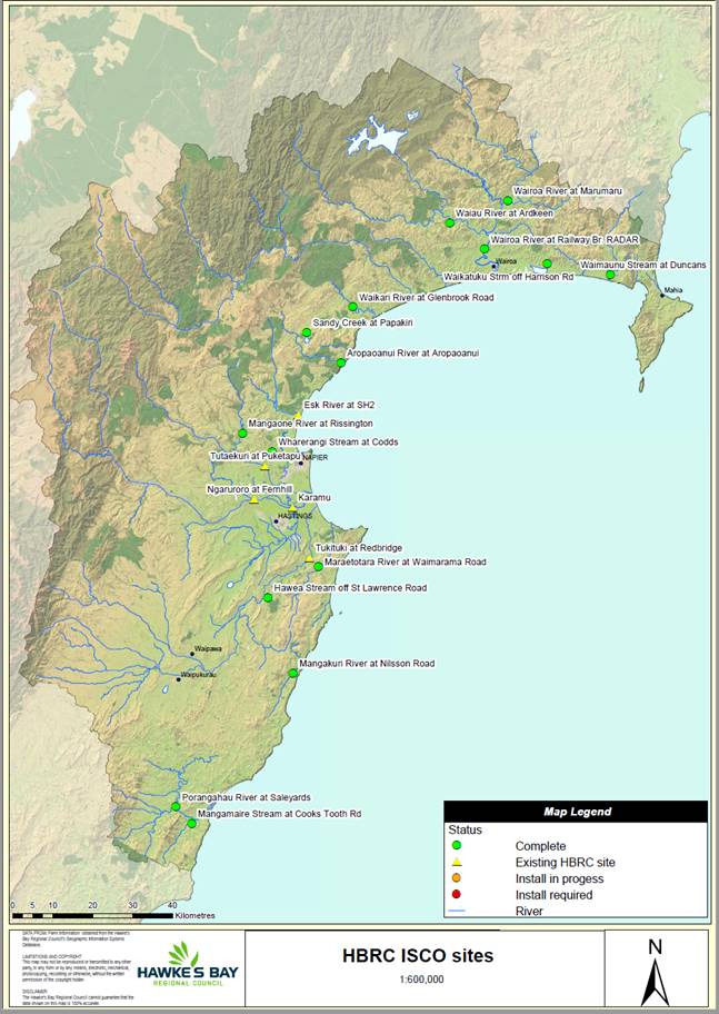
Figure 4: Automated ISCO sampling locations
across Hawke’s Bay.
HAWKE’S BAY REGIONAL COUNCIL
Environment
and Integrated Catchments Committee
10 November 2021
Subject: Tukipo Wetland
Reason for Report
1. This item provides an update on the successful delivery of the 1.6ha
constructed wetland in Tukipo following Hawke’s Bay Regional Council
committing $100,000 of the Recovery Fund to this project in the 2020-21
financial year.
Background
2. Ambitious nitrogen targets have been set in the Tukituki Plan, and
in some cases require instream Dissolved Inorganic Nitrogen (DIN) levels to be
more than halved.
3. Fonterra included the Tukipo catchment to be part of their
Sustainable Catchments programme, due in large part to proactive work from the
Tukipo Catchment Care Group (TCCG). The Tukipo sub-catchment was sitting at
2.32 mg/l, which is almost 3 times over the 0.8 mg/l DIN target and indicated a
66% reduction in instream DIN levels would be required.
4. Ongoing research has proven the effectiveness of constructed
wetlands at removing nitrogen from waterways via biological conversion
(microbial denitrification) rather than plant uptake. This confirms that a
strategic network of constructed wetlands, in combination with on farm
improvements around nutrient management, may help achieve the ambitious
nitrogen reduction targets.
5. The Council Tukituki implementation team believe that constructed
wetlands may form a key part of the strategic Tukituki response, and are very
supportive of the constructed wetland initiative. It is hoped that the outcomes
from this project will provide a model that is transferable to other properties
in Hawke’s Bay. A well-designed constructed wetland that is sized to 1%
of the catchment area can remove 20-30% of the nitrogen passing through it.
6. Fonterra provided HBRC and the TCCG funding to undertake a scoping
exercise to identify willing landowners who had suitable sites to build a
constructed wetland to achieve DIN reduction on a catchment scale ($30k). A
further $226k was then provided to design and construct a wetland on the most
promising site.
7. Over this same time period, NIWA obtained funding from MPI’s Sustainable Land Management and Climate
Change: Freshwater Mitigation Fund to comprehensively monitor 6
constructed wetlands to collect high quality data to refine our understanding
on wetland performance and help improve the wetland modules available in
Overseer or for use in other nutrient modelling approaches. The two projects
aligned and so NIWA designed the Tukipo wetland so that it could be used in
their national project.
8. Following completion of the scoping exercise a preferred location
was selected that had full support from the landowner to construct a 1.6ha
wetland to capture and treat water from a 180ha catchment. The wetland was
designed larger than originally expected in order to meet requirements for
inclusion in the national NIWA study.
9. To fit in with project timelines and due to COVID-19 lockdown in
2020 preventing site visits, the wetland design work had to be completed
remotely and was based off LiDAR (remote sensing using pulse lasers to measure
elevation) which gave the most accurate data set available at the time.
10. Prior to
construction beginning the design was double checked with a surveyor building a
3D model for machinery to run off. However, this process revealed that the
LiDAR data underestimated the volume of earth that needed to be moved. This
resulted in the construction costs increasing to exceed the available budget.
11. A
decision was made to proceed with the construction to meet project timeframes.
This meant the wetland earthworks would be completed within available budget,
but the site could not have been planted with the correct wetland plants needed
to ensure a highly functioning constructed wetland in time to be part of the
NIWA monitoring project, unless additional funding as obtained.
12. To fill
the budget gap, a paper was successfully presented to the Corporate and
Strategic Committee on 3 March 2021 seeking $100k to be committed from Councils
$1m Recovery Fund to allow for the complete delivery of this project to ensure
the wetland could be created within the timeframes needed for inclusion into
the NIWA national monitoring programme.
13. Prior to
this decision the constructed wetland project had been exclusively funded by
Fonterra (approx. $250k), with Council only committing a small amount of staff
time. Councils’ investment provided an opportunity to further collaborate
with national organisations to lead and deliver an exciting research and
development project. The results of which could provide a model that would add
significant value to how we target nitrogen reduction throughout the region and
provide a more holistic understanding of the water quality benefits derived
from wetlands. It would also provide a local farm feature for the Tukituki
community to consider.
Discussion
14. Construction
of the wetland was completed in May 2021 which included the planting of
approximately 24,000 native wetland plants. Further details on the development
of the wetland will be presented during the Environment and Integrated
Catchment Committee meeting.
15. A
successful planting day was held involving Tukipo Catchment Care Group and a
range of HBRC from Regulation, Consents/Compliance and Catchment Delivery.
16. HBRC
Comms Team prepared a media release covering the successful delivery of the
project that highlighted the collaborative approach between key organisations
and landowners to investigate possible solutions to current water quality
issues. This was covered by multiple radio and print media as well as TVNZ One
News and included staff/landowner interviews. The landowner has welcomed
multiple calls from other interested farmers based on his interview.
17. NIWA are
committing their expertise and the equipment required to continuously monitor
flow, nitrate, turbidity and floods, alongside covering the laboratory costs
for monthly monitoring at the wetland inflow and
outflow for three years with monitoring set to begin late summer. The
expectation is that a well-designed wetland that is sized to 1% of the
catchment area can remove 20-30% of the nitrogen passing through it.
18. The collaborative approach taken to deliver this project has helped
build and strengthen relationships with rural landowners in the region,
creating positive solution focused discussions about how to improve water
quality.
19. Hawke’s
Bay region has a paucity of functioning wetlands and the establishment of this new wetland will also be of significant value to the region for
biodiversity through increased habitat.
Next Steps
20. Regional
Councils and NIWA are exploring how best to provide nitrogen credits to farmers
who are using constructed wetlands to help meet their nitrogen reduction
targets.
21. Fonterra
are interested in committing further funding for projects targeting water
quality improvement in the Tukituki catchment. We are currently in discussions
around funding a scoping exercise for the entire Ruataniwha Plains, using Lidar
and land use layers to identify optimum areas for locating catchment scale
constructed wetlands for Nitrogen stripping. This approach will seek to
identify the best locations for a strategic network of constructed wetlands of
various sizes on both private and HBRC owned land.
Decision Making
Process
22. Staff
have assessed the requirements of the Local Government Act 2002 in relation to
this item and have concluded that, as this report is for information only, the
decision making provisions do not apply.
Recommendation
That the Environment and Integrated
Catchments Committee receives and notes the “Tukipo Wetland” staff
report.
Authored by:
|
Dr Andy Hicks
Team Leader/Principal Scientist Water
Quality and Ecology
|
Thomas Petrie
Programme Manager Protection & Enhancement
Projects
|
Approved by:
|
Iain Maxwell
Group Manager Integrated Catchment
Management
|
|
Attachment/s
There are no
attachments for this report.
HAWKE’S BAY REGIONAL
COUNCIL
Environment
and Integrated Catchments Committee
10 November 2021
Subject: Update
on IRG Flood Control Resilience Funded Projects
Reason for Report
1. This report provides an update on the four projects approved for
funding as part of the Crown’s Flood Control Resilience Funding with the
Infrastructure Reference Group managed by Kānoa – Regional Economic
Development & Investment Unit, formerly known as the Provincial Development
Unit.
Background
2. Council has received IRG funding for a total amount of up to $19.2m
(plus GST, if any) which is a 64% contribution to four projects.
3. Works commenced on all four projects in late
November 2020.
Discussion
Project 1: Heretaunga
Plains Flood Control Scheme (HPFCS) Levels of Service - $20m
4. The HPFCS Levels of Service project will review and upgrade sites
across the Tūtaekurī, Ngaruroro, Lower Tukituki and Clive
rivers, to increase flood protection across the scheme to a 1 in 500-year
event.
5. This project is programmed over a three-year with IRG funding but
will carry on after this period and will build upon existing river modelling,
condition assessment and property analysis undertaken as part of the Heretaunga
Plains Flood Control Scheme level of service review.
6. HBRC co-funding of $7.2 million is required to match IRG funds of
$12.8 million.
7. Prioritisation of 39 stop bank sites is being established by Asset
Management based on freeboard levels, risk of overtopping, consequence of
failure and value of assets protected. Sites are being assessed in order of
priority and at least 8 sites will be upgraded through the course of this
project. Assessment and upgrade of remaining sites will continue beyond the
3-year programme.
8. Physical works at Taradale stop bank are due to commence early
November. Early contractor involvement has allowed planning and methodology of
these works to be fast tracked in order to meet the summer 2021/22 construction
window. Cycle trail detours have been implemented and enabling works, including
tree removal, cycle trail upgrades and specimen tree relocation have been
completed. Targeted completion for stop bank strengthening May 2022.
9. Investigations are complete for Ngatarawa and Roy’s Hill,
design optioneering is underway for both sites. East Clive and Moteo field
investigations complete, analysis is underway and design optioneering due
December 2021.
10. To date,
works completed are:
|
Site Name
& Location
|
River
|
Works Completed to Date
|
Proposed Works**
|
|
Taradale
Stopbank Strengthening (XS 17 - 22 LHS)
|
Tūtaekurī
|
Archaeology
assessment, geophysical testing, Geotechnical investigation, Topographical
survey, Preliminary Design, detailed design
|
Increase
height of stopbank for overtopping, increased width of stopbank,
|
|
Moteo
Stopbank Strengthening (XS 43b - 47 RHS)
|
Tūtaekurī
|
Archaeology
assessment, geophysical testing, Geotechnical investigation scoping,
Topographical survey, field investigations
|
TBC pending
output from geotechnical testing and ground model. Native planting programme
|
|
Omaranui (XS
23-41 RHS)
|
Tūtaekurī
|
Archaeology
assessment, Topographical survey
|
Increase
height of stopbank for overtopping
|
|
Haumoana
Stopbank Strengthening (XS 1 - 4 RHS)
|
Lower
Tukituki
|
Archaeology
assessment, Geotechnical investigation scoping, Topographical survey
|
Increase
height of stopbank for overtopping
|
|
East Clive
Stopbank Strengthening (XS 1 - 4 LHS)
|
Lower
Tukituki
|
Archaeology
assessment, Geotechnical investigation scoping, Topographical survey, field
investigations
|
Increase
height of stopbank for overtopping
|
|
Pakowhai
Park (XS 15-20 RHS)
|
Ngaruroro
|
Geophysical
testing, Topographical survey
|
TBC pending
output from geophysical testing
|
|
Raupare
Lower (XS 20-27 RHS)
|
Ngaruroro
|
Geophysical
testing, Topographical survey
|
TBC pending
output from geophysical testing
|
|
Ngatarawa
(XS 49 - 51 RHS)
|
Ngaruroro
|
Archaeology
assessment, Geotechnical investigation underway, Topographical survey, field
investigations
|
TBC pending
output from geotechnical testing and ground model. Extensive native planting
programme
|
|
Roy's Hill
(XS 41 - 44 RHS)
|
Ngaruroro
|
Archaeology
assessment, Geotechnical investigation underway, Topographical survey, field investigations
|
TBC pending
output from geotechnical testing and ground model. Extensive native planting
programme
|
|
Meeanee d/s
motorway (XS 13-17 LHS)
|
Tūtaekurī
|
Topographical
survey
|
TBC pending
output from geotechnical testing
|
|
Haumoana
Upstream of Blackbridge (XS 4 - 10 RHS)
|
Lower
Tukituki
|
Archaeology
assessment, Topographical survey
|
Increase
height of stopbank for overtopping
|
|
Farndon Road
Erosion
|
Clive
|
Works scoped
for Engineering Panel
|
Scour
protection to Farndon Road
|
** Subject to outputs from site investigations, geotechnical modelling
and any additional hydraulic modelling
11. Request
for Tender will be sought for significant native planting programme to support
environmental outcomes at Moteo, Ngatarawa, Roy’s Hill and East Clive
berms. This package of works shall increase biodiversity through support from
community engagement and align with proposed Public Use of Rivers (PUR)
projects.
12. HBRC have committed to deliver eight stop bank strengthening
projects over the three-year period through IRG funded works. Further, by
undertaking integrity investigations of similar or higher priority sites in
tandem, HBRC provides confidence in the resilience of our flood protection
assets and thus achieve the objective of increasing climate resilience of HPFCS
systematically. Should these investigations lead to physical work requirement,
this will add to the following list.
|
Year
|
Committed Projects
|
|
1
|
Taradale
Stop Bank (earthworks, stop bank upgrade, PUR)
|
|
2
|
Moteo Stop
Bank (berm improvement – groynes or strategic planting; earthwork
requirement being assessed as part of design)
|
|
2
|
East Clive
(stop bank upgrade required following overtopping assessments; landfill on
riverside presented additional challenges)
|
|
2
|
Ngatarawa
– Berm improvements (Native planting programme)
|
|
2
|
Roys Hill
– Berm improvements (Native planting programme)
|
|
2/3
|
Clive River
@ Farndon Road (erosion protection - potentially sheet piling)
|
|
2/3
|
Omarunui
(stop bank upgrade required & archaeological complications being worked
through)
|
|
3
|
Haumoana
(stop bank upgrade required & archaeological complications being worked
through)
|
|
3
|
Pakowhai
Park (earthworks, stop bank upgrade, PUR)
|
|
3
|
Haumoana
upstream of Blackbridge (earthworks, stop bank upgrade)
|
13. FY 20-21 expenditure was $832k against a projection of $944k.
14. The
estimated value of FY 2021-22, 2022-23 and 2023-24 planned works is $10.68
million, $4.62 million and $3.9 million respectively. In 2021-22 this
includes stop bank strengthening construction works on two sites (Taradale and
East Clive), detailed design of five sites (based on results from geotechnical
investigations), commencement of investigative work on further six sites.
15. FY
2022-23 planned works includes stop bank strengthening construction works on at
least further four sites, detailed design of two sites (based on results from
geotechnical investigations) and completion of environmental enhancement of 5
sites.
16. FY
2023-24 planned works includes stop bank strengthening construction works on at
least further two sites and completion of environmental enhancement of 3 sites.
Project
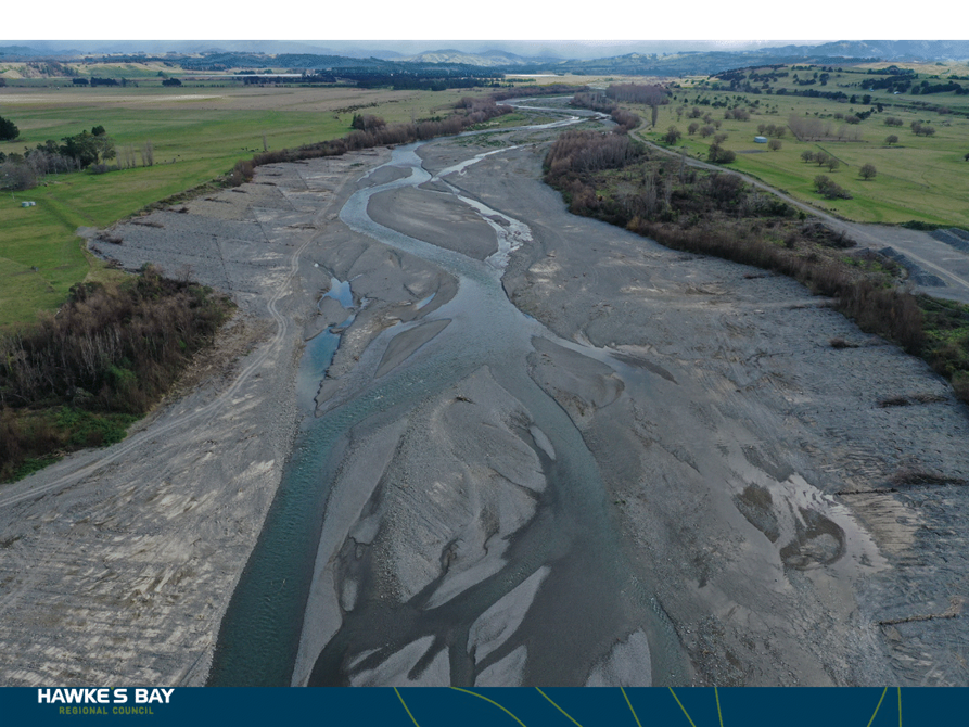
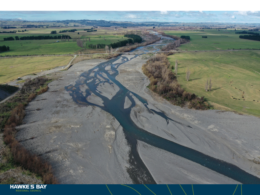
2: Upper Tukituki Gravel Extraction Flood
Control Scheme - $8 million
17. The Upper
Tukituki (UTT) Gravel Extraction project will seek opportunities to subsidise
transportation of gravel from this scheme with a focus on competitive tendering
and supporting the local economy. Gravel extraction is required to
maintain existing nameplate capacity of 1:100 level of protection within this
scheme. As a consultation topic in the 2020 Long Term Plan, Council agreed to
fund the HBRC co-contribution of $2.88m from the UTT scheme through a long term
loan allowing the project to proceed.
18. As part
of the procurement process, Registrations of Interest (ROI) were sought through
GETS in order to pre-qualify gravel extraction contractors. A request for
extension of time was received from the Chief Executive of the Aggregate and
Quarry Association on behalf of their members, this was subsequently awarded
delaying the deadline to 22nd October. A total of 24 submissions
were received through the ROI process.
19. A Request
for Tender (RfT) has been drafted to invite pre-qualified tenderers to submit
on Tranche 1 sites. It is anticipated IRG contracts for Tranche 1 shall be
awarded early December 2021 with a total volume of 120,300m3 gravel
available for extraction. Tranche 1 sites (reaches) shall be
“auctioned” at $4/m3 in order to encourage local contractors
to extract.
20. HBRC
shall provide UTT ratepayers with a project update on 30 November 2021, this
was due to take place in September but was postponed due to COVID restrictions.
21. To date,
HBRC has completed:
21.1. Gravel
material testing programme - results were made available to all tenderers as
part of the ROI.
21.2. Prioritisation
of key reaches – Determined on the following criteria: Freeboard (related
to 100 year flood risk), Average annual flood risk (related to availability),
Lateral erosion risk. This allows extraction to focus on areas which are
critical to the flood protection of the UTT scheme.
21.3. Availability
of gravel – based on prioritisation, data provided as part of ROI to
tenderers and shall assist with programming. This data has also been shared
with local contractors, upon request, following the last public meeting.
21.4. Identification
of additional access – HBRC Schemes Team assisting with landowner
discussions for critical access.
21.5. Request
for Information from industry – 17 submissions received relating to cost
for extraction and transportation. This data will underpin the project’s
rationale for reasonable subsidised costs, specifically relating to
transportation of material.
21.6. Public
meetings with both ratepayers and contractors to provide updates on project
status. Contractor representation at public meetings was attended by small and
medium sized local businesses as well as larger businesses from out of the
region. HBRC have also met on site with a small local contractor to better
understand their business and how they might support any potential Chilean
Needle Grass (CNG) studies.
21.7. Assessment
of known archaeological assessment sites – Working with New Zealand
Archaeological Association (NZAA) to map known sites on HBRC GIS with buffer
zones based on site type.
21.8. Liaison
with HBRC Biosecurity and AgResearch to scope a testing programme to manage CNG
within the UTT scheme. Works are likely to benefit out with this programme and
external funding is being considered to achieve successful outcomes.
21.9. Met
with both Heretaunga Taiwhenua and NKII and discussed a full time HBRC
“Kaitiaki” role for supervision of the works for the duration of
the programme.
21.10. Met with Pam Kupa (CHBDC
Pou Whātuia - Māori Relationships Manager) to further explore
opportunities for Kaitiaki role
22. FY
2020-21 expenditure was $298,000 and FY 2021-22 costs are estimated at
$2.99 million.
23. In FY
2022-23 costs for gravel extraction are estimated at $4.712 million.
Project 3: Upper Tukituki Flood Control Scheme SH50/Waipawa
Erosion - $1 million
24. This
one-year project provided engineered erosion protection works on the right and
left bank of the Waipawa river, immediately upstream of SH50 bridge.
25. To
complete the project, HBRC Works Group installed 75 precast concrete akmon
units on the left bank of the Waipawa river, carried out earthworks to cut and
fill gravel to form the new river channel, including excavation, carting and
shaping approximately 70,000m3 of gravel, and installed 3,166 lineal
metres of rail irons and 8,100 lineal metres of wire rope to form permeable
groynes on the left and right banks.
26. An
independent ecological impact assessment undertaken at the site concluded that
the completed project has resulted in an overall net positive effect on
biodiversity.
27. The
planting of 4,700 pole trees in the berm area and a further 1,000 native trees
was undertaken in partnership between Kaitiaki Rangers (Waiohiki Marae) and
Works Group. Training and upskilling was provided to the Kaitiaki Rangers on
this collaborative project which has received positive feedback from Kānoa due to HBRC fulfilling its social
procurement outcomes to engage and upskill Māori/Pasifika businesses.
28. Project
completion was completed at a total value of $1.25 million.
29. HBRC
collaborated with stakeholders and community to prepare a short video
highlighting the project, its challenges and successes. This has been endorsed
by Kānoa and has received fantastic feedback through River Managers SIG.
(Full length video to be played during EICC meeting)
30. A
closedown report for this project shall be prepared for IRG next month.
Following receipt of this, no further reporting shall be provided to Council
for this project.
Project 4: Wairoa River, River
Parade Erosion - $1 million
31. This
one-year project programme will provide steel sheet piled erosion protection
works on left bank of the Wairoa River.
32. Geotechnical
investigations, design optioneering and preliminary design and detailed of the
proposed sheet pile wall have been completed and the physical works contractor
has procured the necessary steel sheet piles. Unfortunately, the COVID Delta
outbreak has postponed the start date from mid-September to early November
2021.
33. The
relocation of the Wairoa District Council watermain has been completed in
collaboration with Wairoa District Council
34. The
proposed steel sheet piled wall is 73 lineal metres with 12 metre screw anchors
which are drilled below the existing River Parade Road.
35. The local
civil engineering contracting company Lattey’s Civil and Precast have
been appointed to as main contractor with Wairoa based QRS providing
sub-contracting services relating to civil works.
36. Planting
of the upstream riverbank with the appropriate trees and bush will provide
stability to the rivers edge whilst also contributing to the biodiversity of
the river. This will allow safe access for the public to the river’s edge
and popular whitebating (Inanga) area.
37. HBRC have
been engaging with local groups Tātau Tātau o Te Wairoa Trust, Wairoa
Reserves Board – Matangirau (WRB) and Wairoa District Council to identify
the aspirations and requirements of this project on the cultural values to the
region. HBRC are in the process of undertaking a cultural impact assessment of
the local Iwi groups, as well as an assessment of environmental impacts on the
fish, birds and plants of the river and surrounding area.
38. FY
2020-21 expenditure was $98k, and FY 2021-22 costs are estimated at $902k.
Decision Making
Process
39. Staff have assessed the requirements of the Local Government Act
2002 in relation to this item and have concluded that, as this report is for
information only, the decision making provisions do not apply.
Recommendation
That the Environment and Integrated
Catchments Committee receives and notes the “Update on IRG Flood
Control Resilience Funded Projects”.
Authored by: Approved
by:
|
David
Keracher
Manager Regional Projects
|
Chris Dolley
Group Manager Asset Management
|
Attachment/s
There are no
attachments for this report.
HAWKE’S BAY REGIONAL
COUNCIL
Environment
and Integrated Catchments Committee
10 November 2021
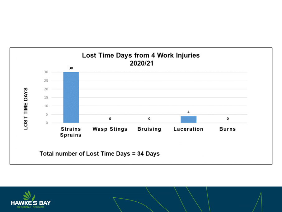
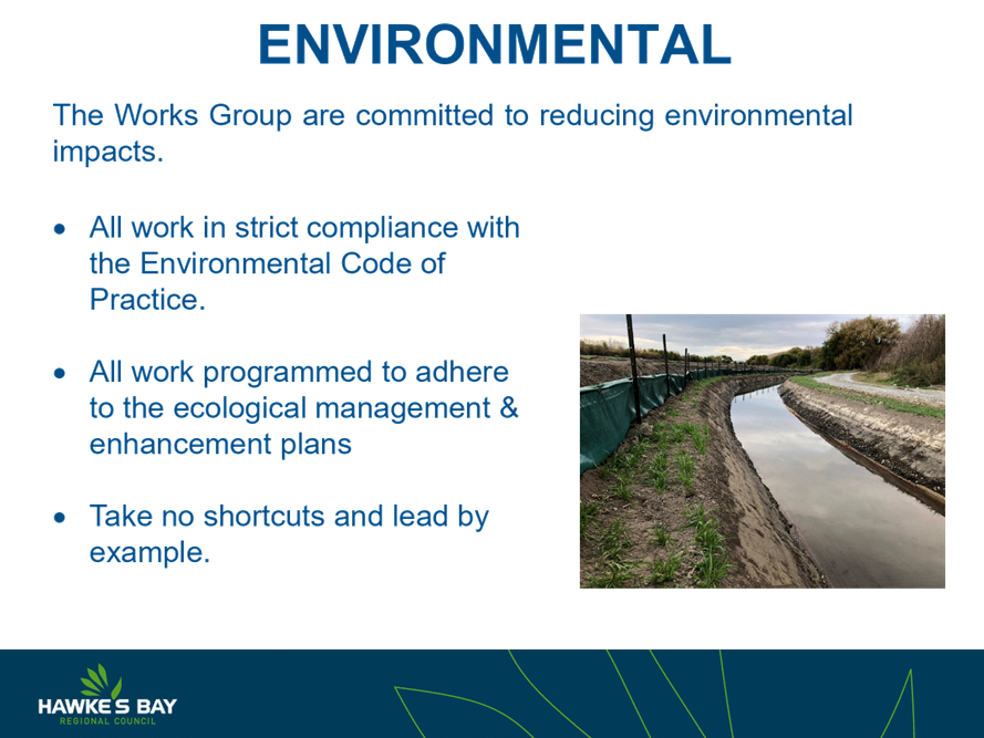
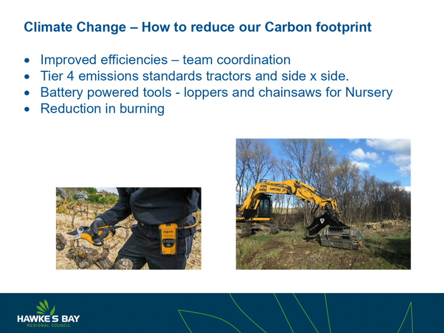
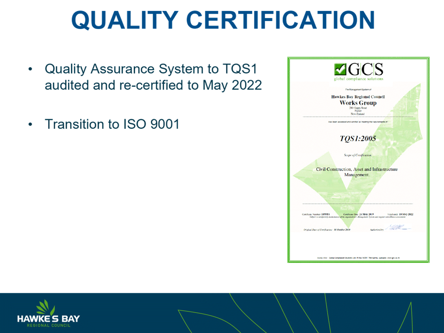
Subject:
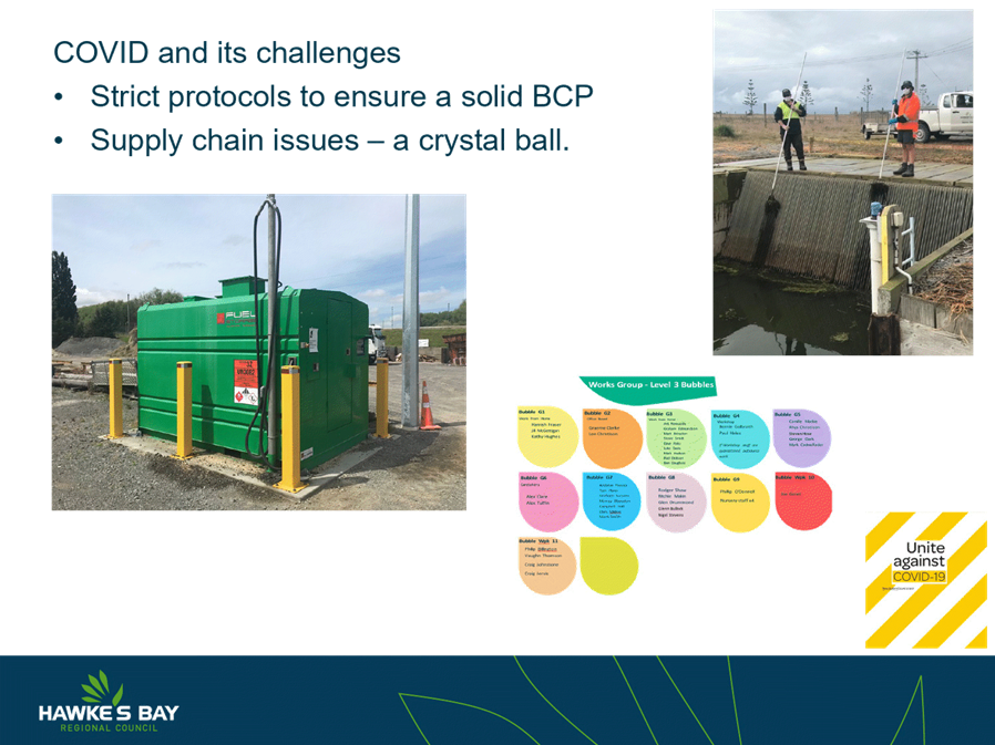
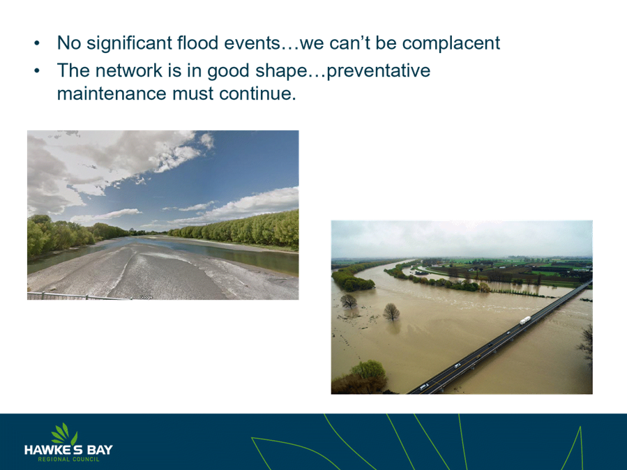
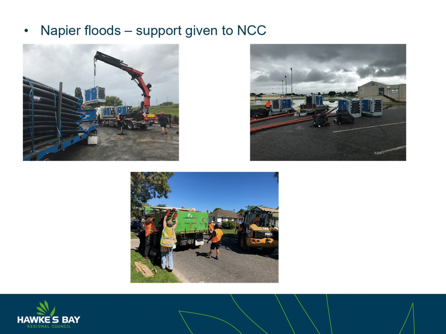
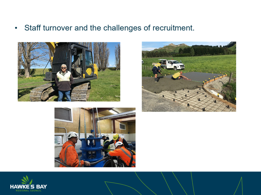
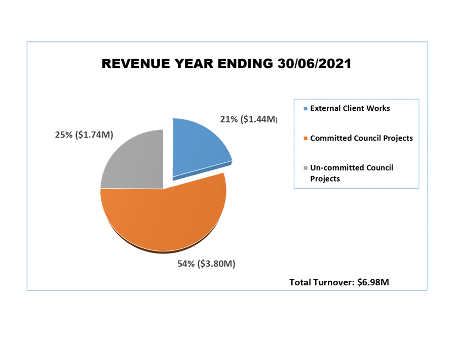
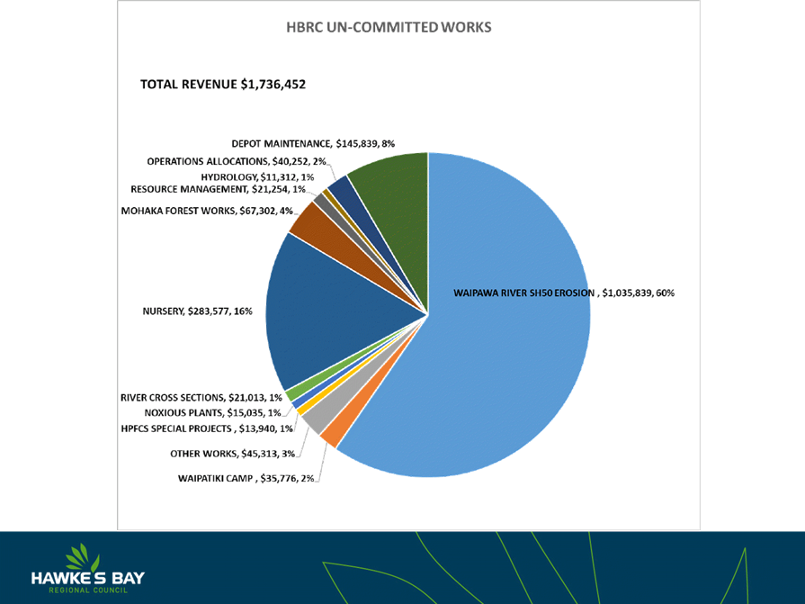
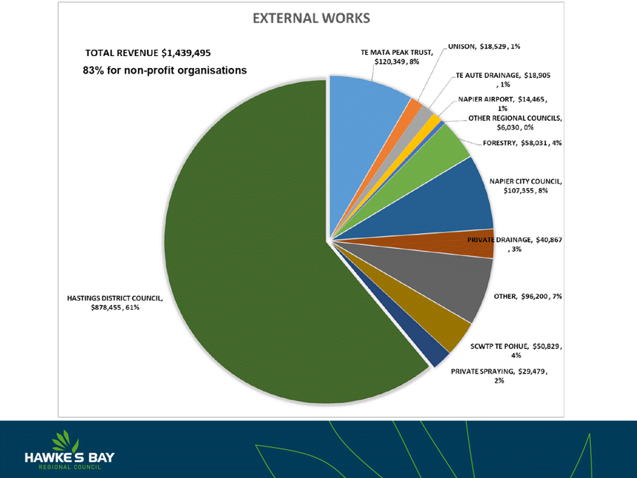
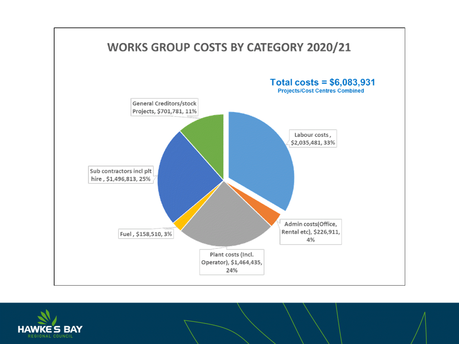
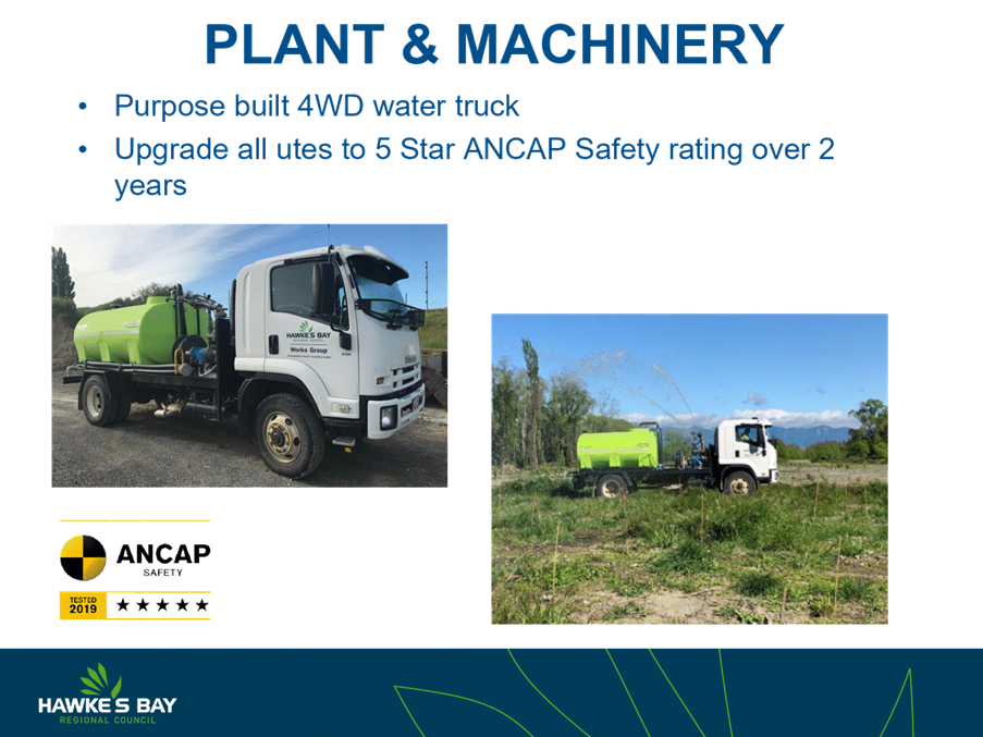
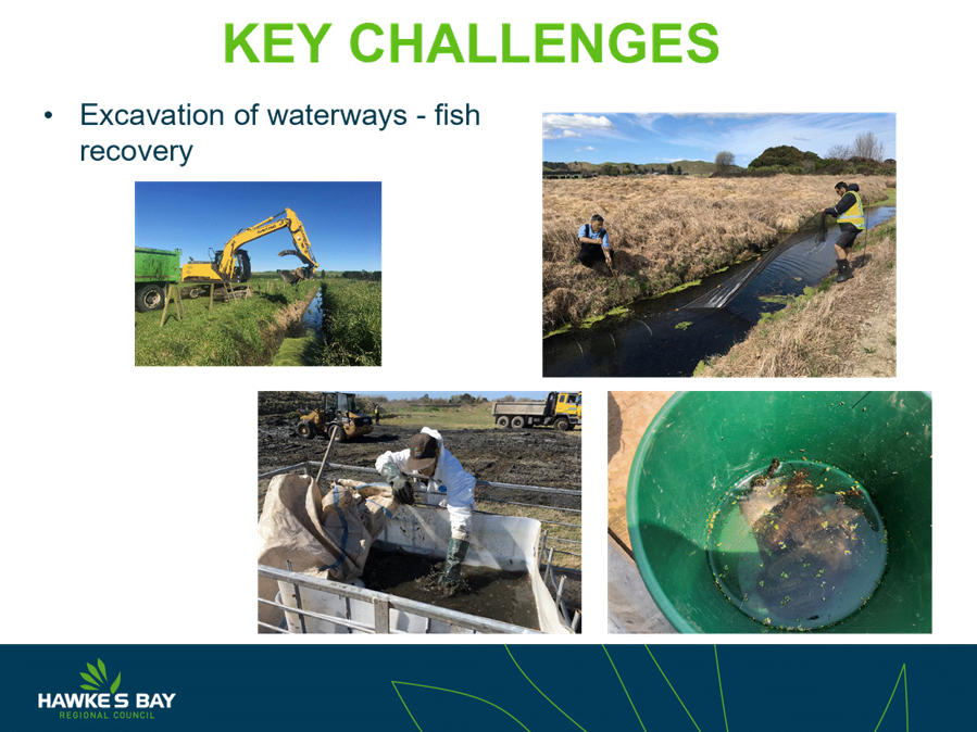
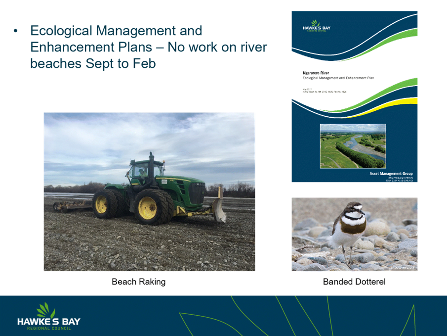
Works Group 2020-21 Performance Update
Reason for Report
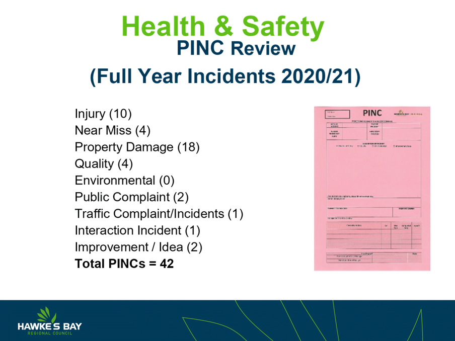
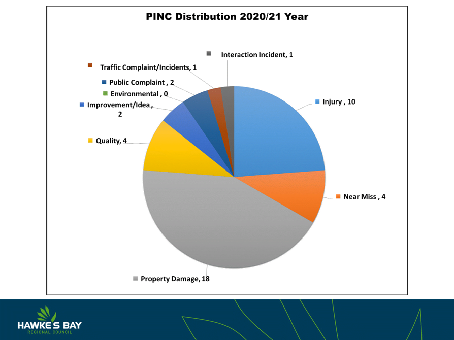
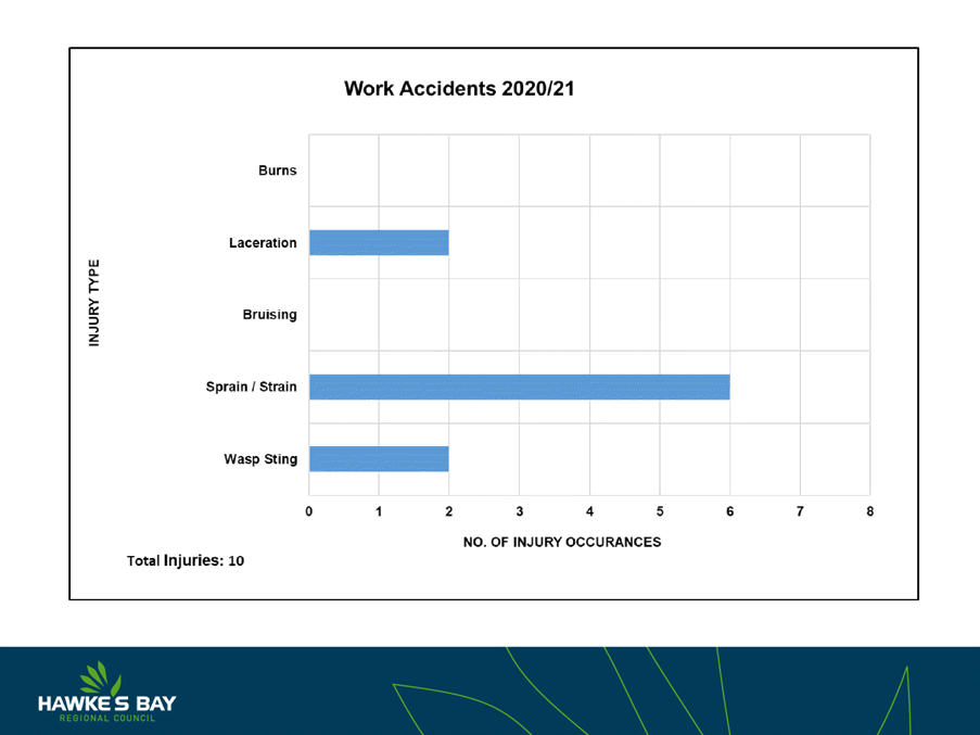
1. This item provides the Committee with an update on the overall
performance of the Works Group for the 2020-21 financial year.
Background
2. Hamish Fraser (Works Group Manager) will attend the meeting to
provide a presentation of an overview of Works Group structure, focusing on
financial performance for the year ended 30 June 2021, along with an update on
Health & Safety, environmental management, and a snapshot of projects
completed throughout the year.
Overview
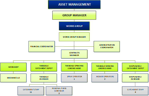
3. The Works Group sits in the organisational structure under the Asset
Management Group of Activities. There are 31 staff in total, based out of both
the Taradale and Waipukurau depots as follows.
4. Works Group is the service delivery arm of Council. The majority of
work (approximately 80%) is performed for Council, and the remaining 20% is for
external clients, performing a variety of functions within the civil
construction sector, focusing on non-profit organisations such as other TLAs.
5. Works Group has a strong emphasis on specialised plant, with staff
who are highly skilled and trained in their relevant fields.
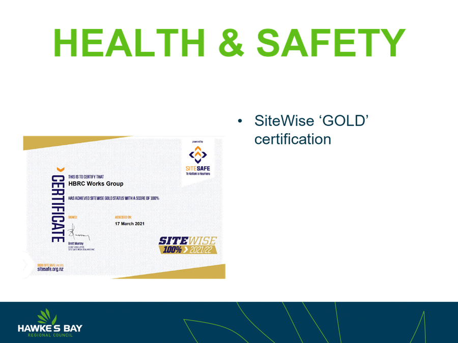
6. Works Group holds a TQS1 standard in Quality and also holds a strong
Health & Safety standard, being SiteWise accredited to a score of 100%.
7. The presentation at today’s meeting will display the financial
performance of the group, will look at Health & Safety, quality, and
environmental performance, and will focus on some key projects that Works Group
has completed throughout the year.
Decision Making
Process
8. Staff have assessed the requirements of the Local Government Act
2002 in relation to this item and have concluded that, as this report is for
information only, the decision making provisions do not apply.
Recommendation
That the Environment and Integrated
Catchments Committee receives and notes the Works Group 2020-21 Performance
Update and presentation.
Authored by:
|
Hamish Fraser
Works Group Manager
|
|
Approved by:
|
Chris Dolley
Group Manager Asset Management
|
|
Attachment/s
|
1⇩
|
Works Group Presentation
|
|
|
|
Works
Group Presentation
|
Attachment 1
|


HAWKE’S BAY REGIONAL COUNCIL
Environment
and Integrated Catchments Committee
10 November 2021
Subject: Chilean Needle Grass
Control Programme Review Update
Reason for Report
1. This item updates the Committee on the review of
Council’s Chilean Needle Grass (CNG) programme. This more detailed review
of the programme was initiated by a Local Government Act 2002 S17a
effectiveness and efficiency review which was presented to Council in September
2020.
Executive
Summary
2. The recommendations from the S17a review
presented to Council in September 2020 outlined that Hawke’s Bay Regional
Council (HBRC) should be spending more on biosecurity. How much more and on
which programmes required a business case analysis through the Long Term Plan
(LTP) and/or Annual Plan process to examine staffing and budget needs based on
the finding in the report.
3. As part of the S17a review process a number of
biosecurity programmes will be going through a more detailed assessment of
their funding and delivery. The Possum Control Area (PCA) programme was the
first of these programmes and is now in a partial plan review process.
Council’s Chilean Needle Grass (CNG) programme is also undergoing a more
detailed review.
4. A number of issues from the S17a review raised
about the CNG programme have had solutions put in place to improve programme
effectiveness and efficiency. These include resourcing for infield delivery and
IT/data management. Some of these such as resourcing are interim solutions to provide
time to support longer term decision making.
Background/Discussion
5. In September 2020 a S17a effectiveness and
efficiency review was carried out of biosecurity programmes. This review meets
the requirements of S17a of the Local Government Act 2002 that requires, that a
local authority must review the cost-effectiveness of current arrangements for
meeting the needs of communities within its district or region for good-quality
local infrastructure, local public services, and performance of regulatory functions.
6. An independent reviewer Kevin Collins from the
Waikato was engaged by the Group Manager ICM. Kevin has a Master of
Environmental Science and Policy degree from John Hopkins University in the
United States. Prior to his consulting career, Kevin managed biosecurity and
biodiversity programmes for Waikato Regional Council. His skills and experience
have been shaped by more than 30 years of practical experience.
7. Kevin has also undertaken the more detail review
of Council’s CNG programme. His report on the programme is attached and
Kevin will present to Councilors on the key context and findings of that
report.
8. While the Biosecurity Act gives councils wide
ranging powers to carry out pest management activities, it does not require any
particular level of pest control or that any pest control occur at all. The Act
stipulates what must be included in a regional pest management plan if a
council chooses to have one, but it does not stipulate outcomes or performance
levels.
9. In line with the point noted above, acceptable
levels of “efficiency and effectiveness” in pest management are
left to the discretion of councils. Councils themselves decide what constitutes
“efficient and effective” pest management in the context of their
region and their community expectations. In practice, this means that the
approach taken by councils often differs widely.
S17a Review
findings on the Chilean Needle Grass programme
10 More staff are needed, at least during the busy
summer season, if the Chilean needle grass programme is to have a greater
chance of delivering
10.1 Staff response - An internal reprioritization of
resources from staff on parental leave or from the predator free Hawkes Bay
programme has taken place. This has seen an additional 2.5 FTEs made available
to the pest plants team from October 2021 to June 2022 (the key pest plants
control season).
11 A more complete business case analysis is needed
to examine whether the programme could be delivered more effectively in other
ways, including different control methods and the use of contractors rather
than landowner responsibility. Land use change options should also be actively
considered.
11.1 Staff response - The more detailed report
presented to the committee today provides the foundation for a more complete
business case analysis. This work will take some time to
develop and will be brought back to council in the 2022-2023 financial year
with a view that resourcing any changes could be made as part of the 2024 LTP.
12 The Chilean needle grass surveillance programme
should be reviewed to determine if it can confidently determine the current
level of infestation and reliably detect spread
12.1 Staff response - The detailed report discusses
the CNG programme objectives and provides initial guidance. More detailed work
will take some time to develop and will take some more time to develop and will
be brought back to council in the 2022-2023 financial year with a view that
resourcing any changes could be made as part of the 2024 LTP.
Decision Making Process
13 Staff have assessed the requirements of the
Local Government Act 2002 in relation to this item and have concluded that, as
this report is for information only, the decision making provisions do not
apply.
Recommendations
That the Environment and Integrated Catchments Committee
receives and notes the “Chilean Needle Grass Control Programme Review
Update” staff report.
Authored by:
|
Campbell
Leckie
Manager Catchment Services
|
|
Approved by:
|
Iain Maxwell
Group Manager Integrated Catchment
Management
|
|
Attachment/s
|
1⇩
|
Chilean Needle Grass Control Programme
Review Report
|
|
|
|
2⇩
|
Chilean Needle Grass Presentation for
EICC
|
|
|
|
Chilean
Needle Grass Control Programme Review Report
|
Attachment 1
|
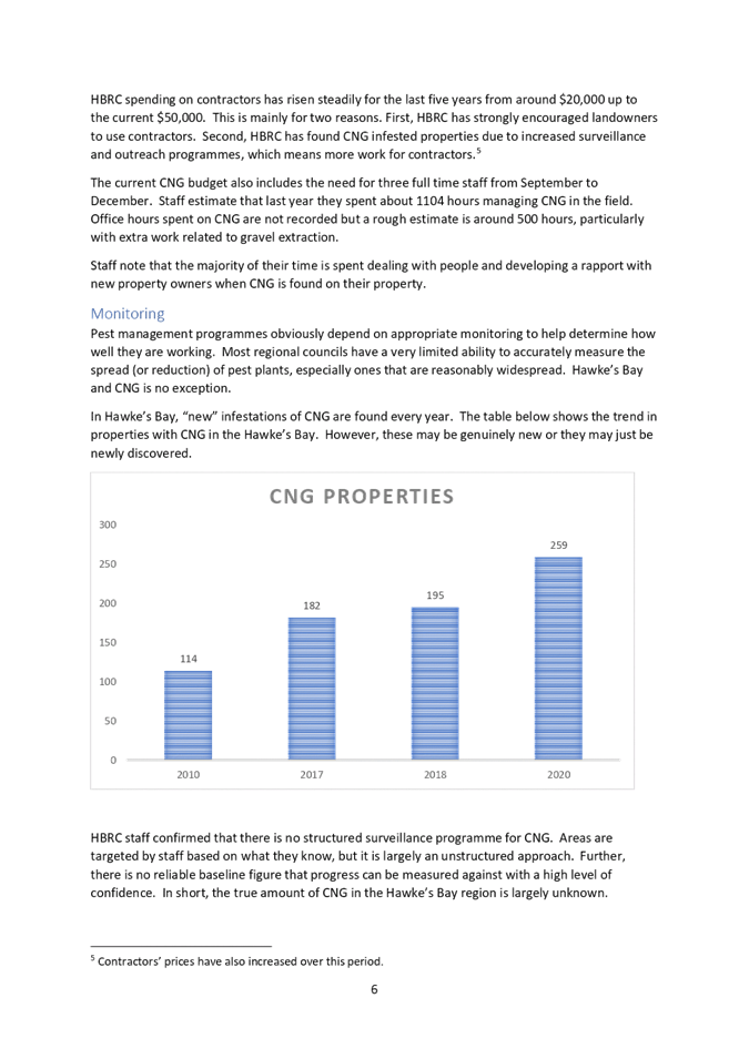
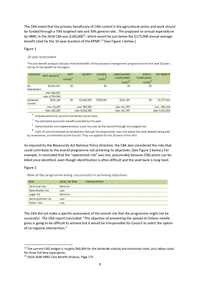

|
Chilean Needle Grass
Presentation for EICC
|
Attachment 2
|
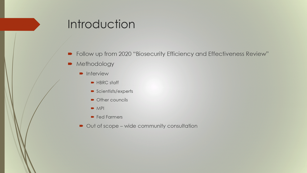
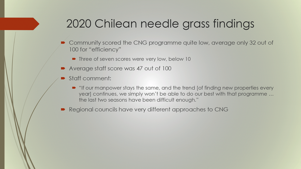
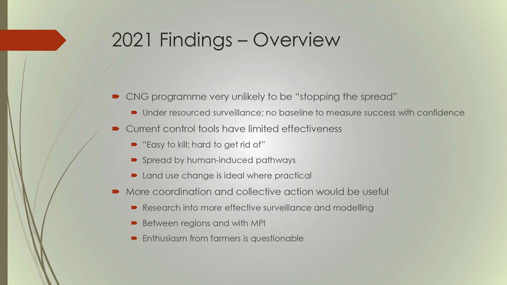
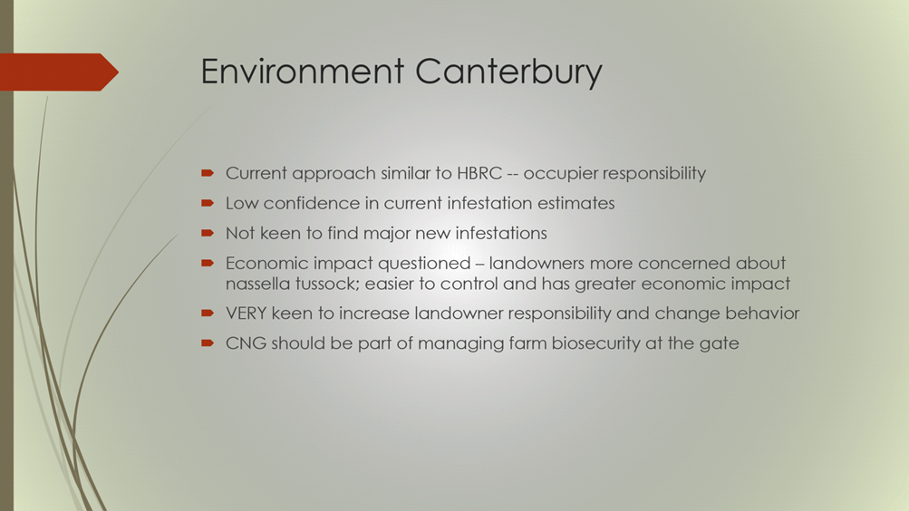
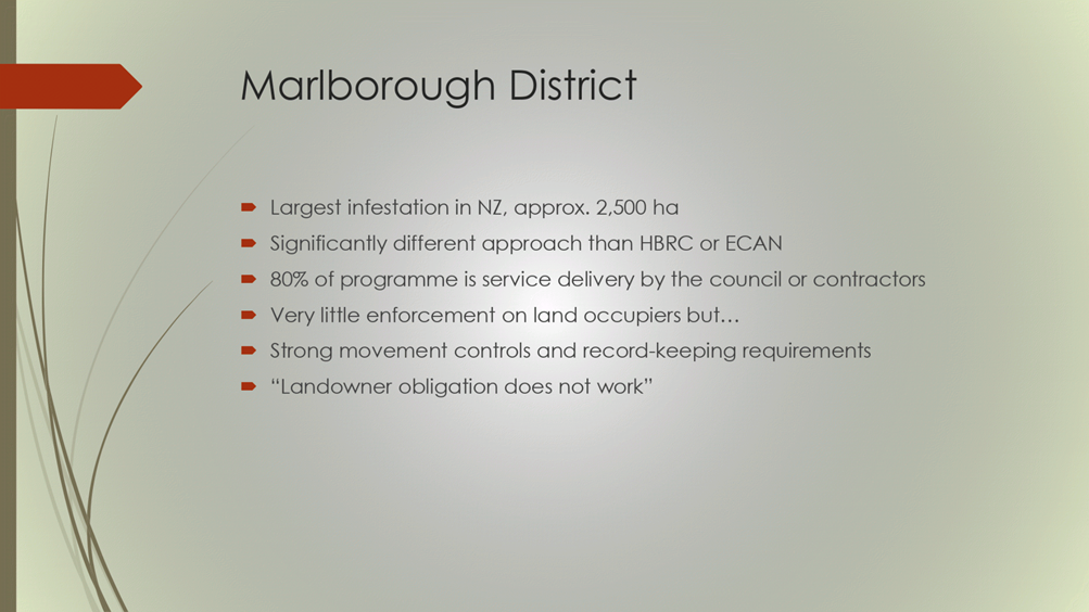
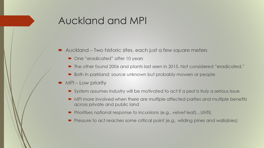
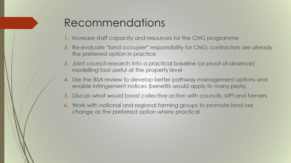
HAWKE’S BAY REGIONAL COUNCIL
Environment
and Integrated Catchments Committee
10 November 2021
Subject: Youth Environment
Council Update
Reason for Report
1. This
item provides the opportunity for representatives of the Regional
Council’s Youth Environment Council (YEC) to give an update on their
activities during 2021 and provide their perspectives on working with youth
around climate change.
Decision Making Process
2. Staff
have assessed the requirements of the Local Government Act 2002 in relation to
this item and have concluded that, as this report is for information only, the
decision-making provisions do not apply.
Recommendation
That the
Environment and Integrated Catchments Committee receives and notes the
“Youth Environment Council Update” staff report.
Authored by:
|
Rebecca
Ashcroft-Cullen
Communications Advisor
|
Sally
Chandler
Community Engagement Coordinator (Schools)
|
Approved by:
|
Drew Broadley
Marketing & Communications Manager
|
Jessica
Ellerm
Group Manager Corporate Services
|
Attachment/s
There are no
attachments for this report.
HAWKE’S BAY REGIONAL
COUNCIL
Environment
and Integrated Catchments Committee
10 November 2021
Subject: Social Ecology Technical
Report from Edgar Burns, Waikato University Professorial Chair
Reason for Report
1. This item updates the Committee on the work of the Associate
Professor in Integrated Catchment Management (AP-ICM) that the Regional Council
is partially funding.
Executive
Summary
2. Council has partnered with the University of Waikato (UoW) to create
an Associate Professor in Integrated Catchment Management.
3. Dr Edgar Burns was appointed to the role in 2019. Dr Burns has
spent the past 18 months gathering information and intelligence relating to a
variety of environmental sociology issues relevant to Council’s
interests.
4. Dr Burns has a series of technical papers he is preparing and will
be bring these at regular intervals to Council.
5. Dr Burns will present his initial technical paper on communication
as it relates to our work.
Strategic Fit
6. This work touches on all aspects of our Strategic Plan and directly
connects to our purpose statement that states we work with our community.
Background &
Discussion
7. Council entered into a Memorandum of Understanding with the UoW in
2018 that supported the creation of the AP-ICM.
8. Through the MoU and Councils LTP, funding has been committed until
at least 2023 and this has allowed us to embark on a new direction and are
investing significantly in changing outcomes in catchments within its
region. There is an acknowledgement that this will require new ways of working
and a greater connection of catchment communities to their land and
freshwater. Council is, for the first time, investing in environmental
sociology.
9. The creation of the AP-ICM role is a step in the journey of that
investment and signals an understanding that managing environmental issues is
more than a biophysical challenge, it is a social challenge also.
10. Investing
in understanding the social processes that are operating as they relate to our
work acknowledges that Council is typically not ‘managing the
environment’ but working to understand and then manage the impacts of
human activities on our environment.
11. Council
staff are not typically trained in environmental sociology practice or theory
and so a partnership with a university has proven to be a cost effective way to
access the academic knowledge. The role of the AP-ICM is to translate
that academic knowledge into practical ways of working for our staff. It
is recognised that this will take some time to ‘trickle down’ and
be operationalised.
12. As part
of the process of capturing and transferring knowledge the AP-ICM will be
producing a series of technical papers that will be disseminated to staff as
they are produced. The attached paper is the first in this series and
will be presented by Dr Burns.
Decision Making
Process
13. Staff
have assessed the requirements of the Local Government Act 2002 in relation to
this item and have concluded that, as this report is for information only, the
decision making provisions do not apply.
Recommendation
That the Environment and Integrated
Catchments Committee receives and notes the “What Forms of Communication
Work for HBRC, Technical Report from Dr Edgar Burns, Waikato University
Associate Professorial Chair”.
Authored and
Approved by:
|
Iain Maxwell
Group Manager Integrated Catchment
Management
|
|
Attachment/s
|
1
|
What Forms of
Communication Work for HBRC? Technical Report
|
|
Under
Separate Cover
|
HAWKE’S BAY REGIONAL
COUNCIL
Environment
and Integrated Catchments Committee
10 November 2021
Subject: Discussion of Minor
Items not on the Agenda
Reason
for Report
1. This document has been prepared to assist
Committee Members note the Minor Items Not on the Agenda to be discussed as
determined earlier in Agenda Item 6.