HAWKE’S BAY REGIONAL COUNCIL
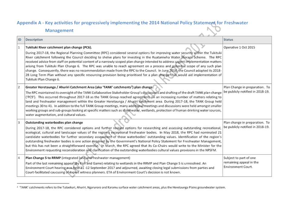
Regional
Planning Committee
Wednesday 12 September 2018
Subject: Oil & Gas Plan
Change Options
Reason for Report
1. This report
outlines the Government’s recent announcements on oil and gas exploration
in New Zealand in the context of Council’s proposed Oil and Gas plan
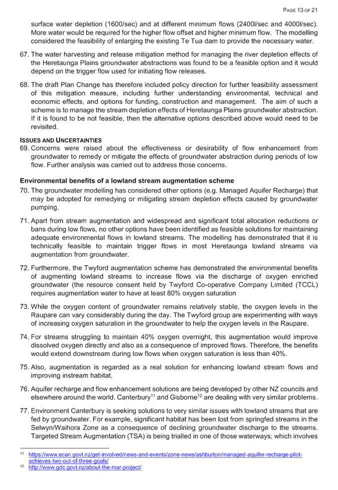
change. This report outlines several options for the Committee to
consider (including a summary of pros and cons). Finally, the paper will
seek direction from the Committee as to next steps regarding the Oil and Gas
plan change project.
Background
Government
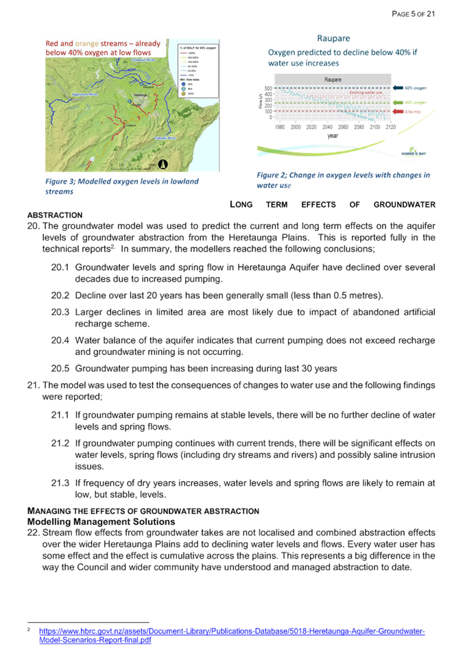
announcements
2. On 12 April
2018 the Government announced that there will be no further offshore oil and
gas exploration permits granted, with the exception of the 2018 block offer
which will be limited to onshore acreage in Taranaki alone. Onshore block
offers will continue in Taranaki for the next three years and will be reviewed
after that. The announcement does not impact upon the 31 active
exploration and mining permits (22 of which are offshore).
3. Further to
this, on June 5 Government released a series of documents generated by
officials in reaching this decision. This bundle of documents consists of
details around the current state of the oil and gas industry in New Zealand,
further information around the upcoming onshore Taranaki block offer, and
emails between officials released in the Hawke’s Bay.
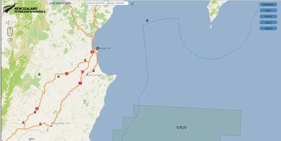
4. In regards to
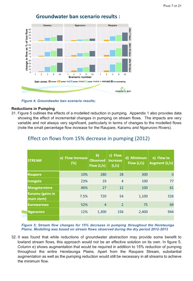
Hawke’s Bay, there is only one currently active permit located offshore
that overlaps into the jurisdiction of Council- (permit 57073 held by OMV New
Zealand Limited) as shown in Figure 1 (note that the dotted blue line denotes
Council’s regional boundary out to the 12 nautical mile limit).
That permit is due to expire in 2030.
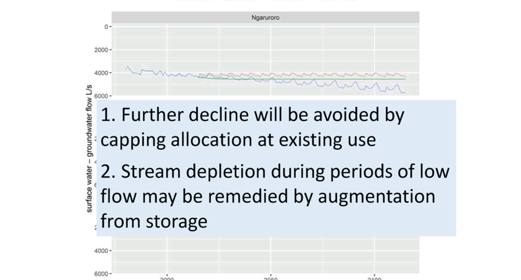
Figure
1 – location map of Exploration Permit #57073 held by OMV New Zealand
Limited
5. For the
avoidance of doubt, in 2012 an exploration permit was granted to TAG Oil
limited for onshore exploration in the Central Hawke’s Bay region, but
that permit expired in 2017.
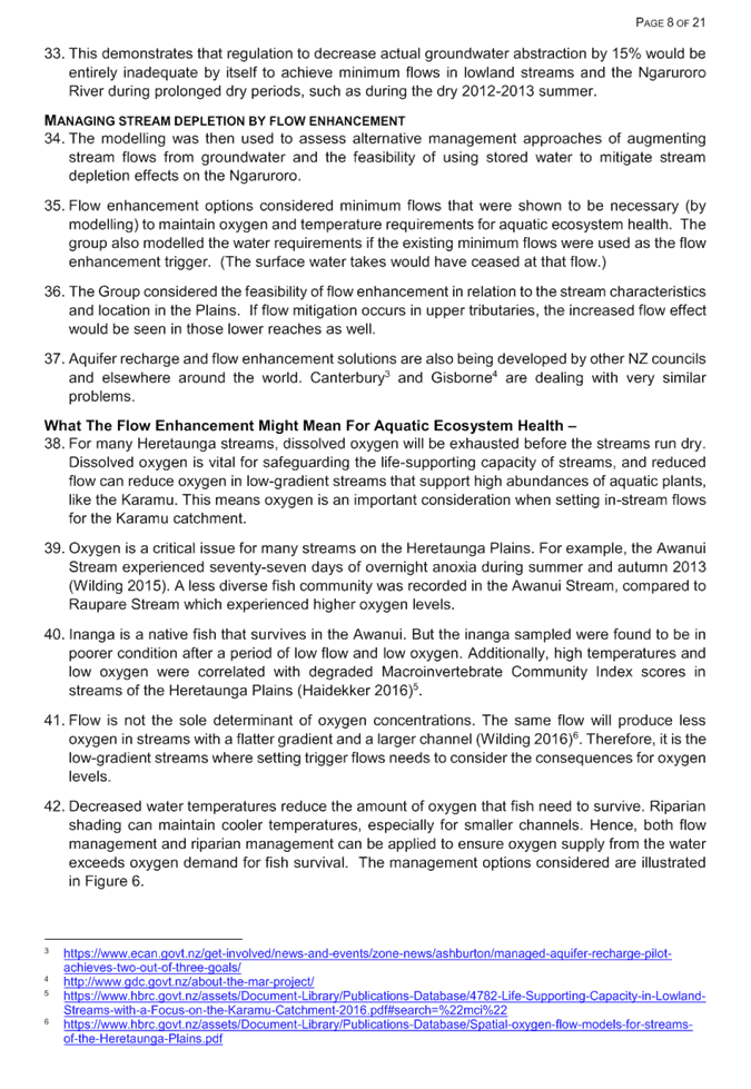
What is unknown?
6. Despite the
further release of background information in early June, there is still a level
of uncertainty concerning the Government’s announcements. Based on our
most recent contact with MBIE officials (24 August) we understood that
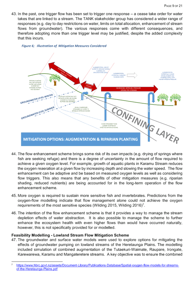
legislative change is being progressed. No further information is
available regarding the nature and extent of those changes.
7. A key question
is whether or not these proposed legislative changes will elevate the status of
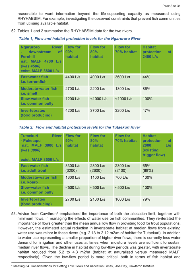
the ban from policy decisions to legislation. Once in legislation, this would
be extremely difficult to reverse by future Governments. Staff will
remain in contact with MBIE officials.
Current situation
8. At the March 21
RPC meeting staff provided a recap and update on the Oil and Gas plan change
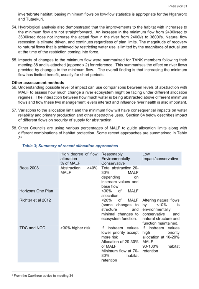
project. To broadly summarise that recap report, feedback had been sought
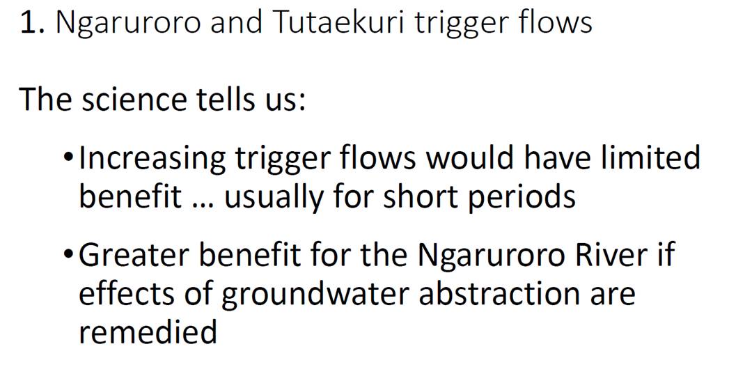
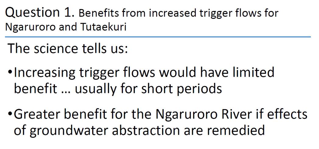
on the proposals through a series of meetings with targeted stakeholders.
Council also had an online feedback form on its website in order for the public
to express views on oil and gas exploration in the region.
9. In mid- late
April, staff in conjunction with relevant tangata whenua representatives were
in the process of organising three Hui-a-iwi across the northern, central and
southern parts of Hawke’s Bay. However, in light of the
announcements made by the Government and discussions with several RPC members,
it was decided not to proceed with the hui until further information about
implications of the Government’s announcement were better understood.
10. Fundamentally, the
Government’s announcements would mean no new offshore or onshore oil and
gas exploration permits would be granted for the Hawke's Bay region. That
broadly aligns with the Committee’s earlier preferred proposition to
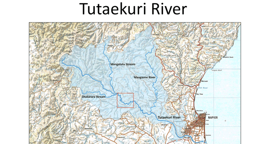
prohibit oil and gas exploration activities in specified parts of the region,
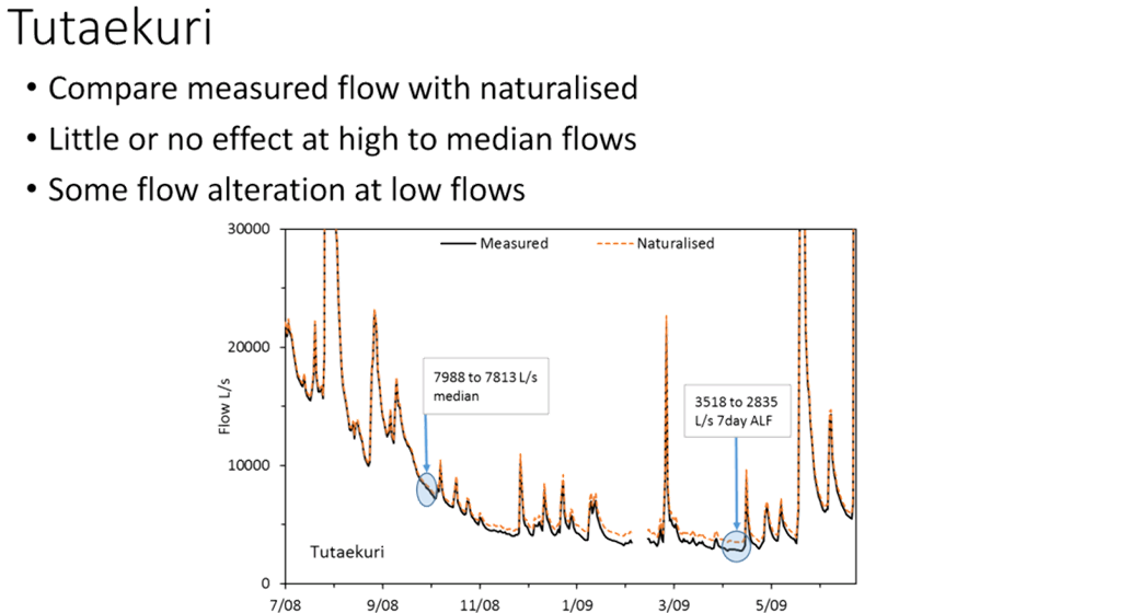
including marine areas.
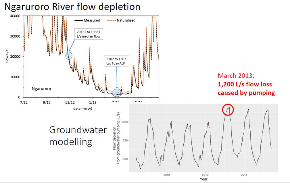
11. It appears that the
Committee’s pre-emptive move to propose prohibiting oil and gas
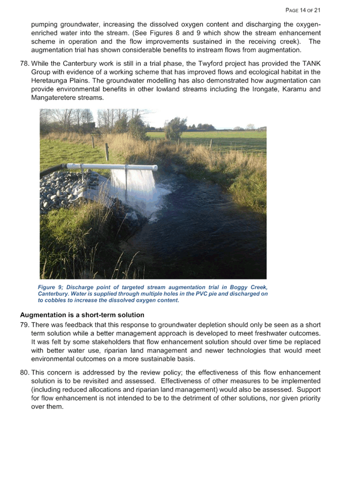
exploration activities in the region’s sensitive aquatic and marine
areas, is now overtaken by the Government’s broader sweeping policy shift
on oil and gas exploration in New Zealand.
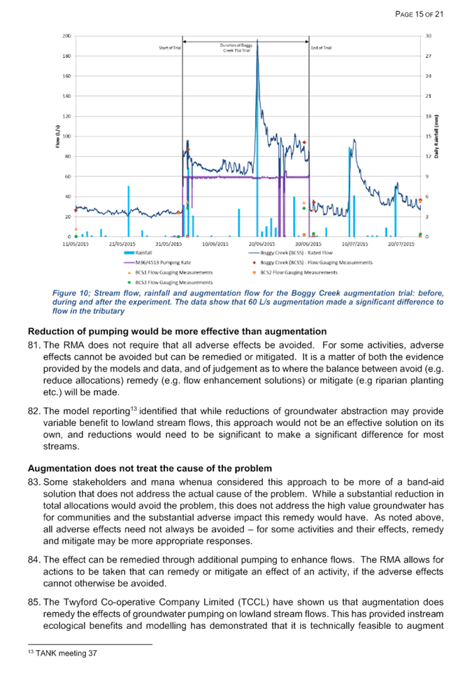
Options
12. Staff are of the view that
in light of the announcements there are predominantly two options. An
assessment of each option along with a summary of pros and cons is outlined
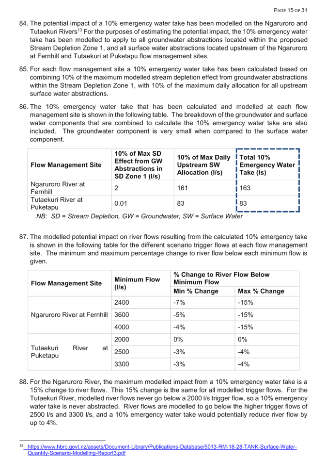
following.
Option 1: Proceed with Oil and Gas plan change
i.e. ‘status quo’
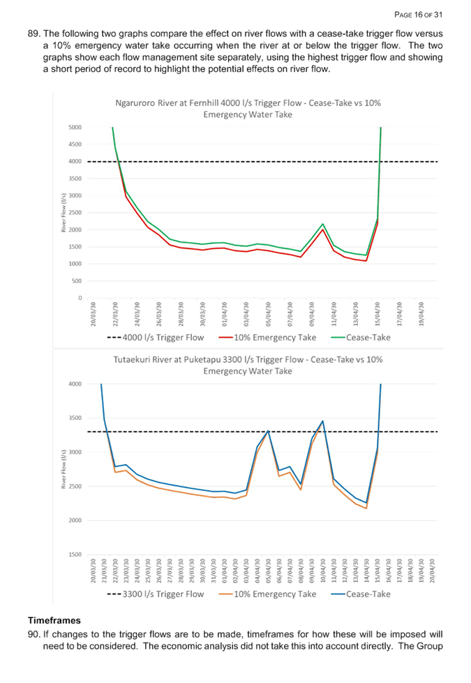
13. This option recognises
that despite these announcements, Council has embarked on a programme of plan
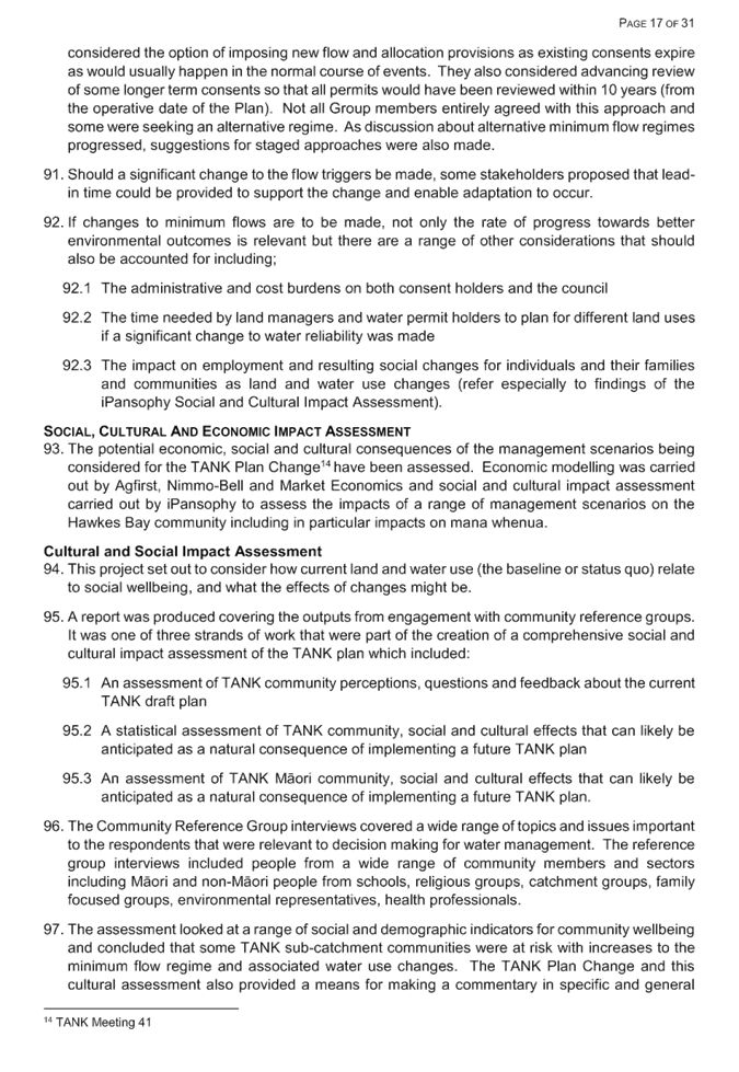
change work that reaches back to a decision by the Regional Planning Committee
in November 2016. In this option, staff would continue with the existing
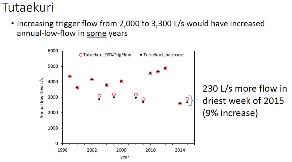
project plan and recommence stakeholder consultation including consultation hui
and eventually drafting a stand-alone plan change to notify, call for public
submissions, hold hearings, issue Council’s decisions on those
submissions and deal with potential Environment Court appeals.
14. Proceeding with the work
would result in unnecessary effort and expenditure, given that the Government
has effectively curtailed any such activities in the region. Furthermore,
there is a risk that Council proceeds without having the benefits of more
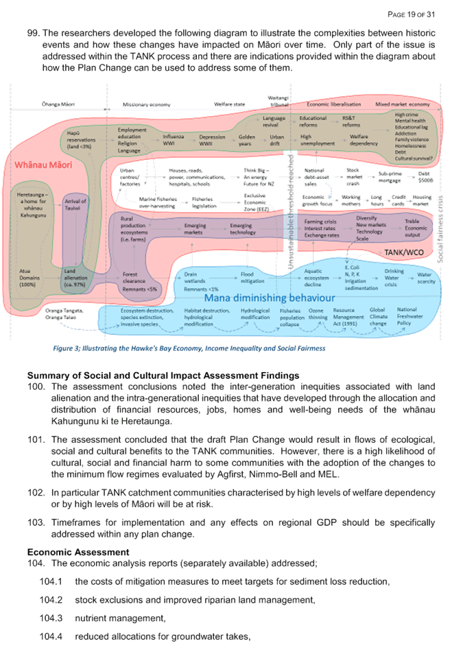
detail from NZP&M regarding the implications of the Government’s
announcement.
Option 2: ‘Shelve’ the current
project and incorporate into the future regional plan reviews (preferred
option)
15. This is the preferred
option of staff. Council is scheduled to commence parallel reviews of the
Regional Resource Management Plan (RRMP) and Regional Coastal Environment Plan
(RCEP) in 2020. Under this option, staff would wrap up current work on
the plan change and re-purpose the intel for informing the future RRMP and RCEP
review projects.
16. The upside to this
approach is that Council does not need to replicate efforts unnecessarily and
would avoid further expenditure of Council’s resources to regulate an
activity that is already curtailed by Central Government. This approach
also allows for a consideration of the effects of oil and gas exploration
within the wider context of the RRMP and RCEP, particularly as they relate to other
activities in the plans. It also allows time for more detail on the
Government’s position to emerge, which in turn will ensure Council is
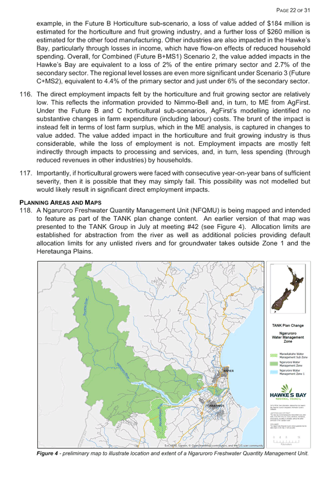
better equipped to understand impact and implications of these decisions.
17. It is noted that the RRMP
and RCEP Reviews are not due to commence until 2020. While it would be
several years until any new rules came into effect, the Government’s
announcement clearly indicated Block Offer processes over the next three years
will be open for onshore Taranaki only. The likelihood of new oil and gas
exploration permits being issued and activities occurring in the Hawke's Bay
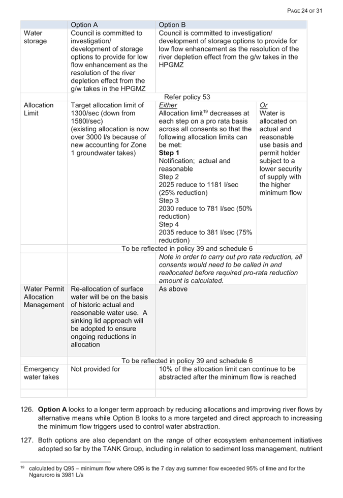
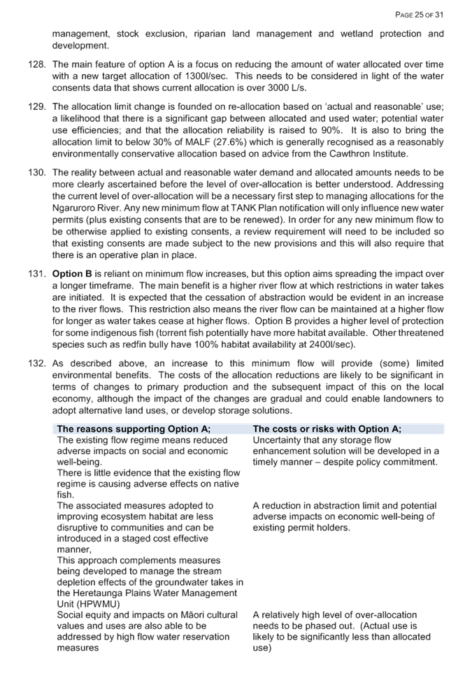
region in the meantime is considered minimal.
Comments on risks
18. There are both perceived
and actual risks associated with closing the Oil and Gas plan change
project. Firstly, a perceived risk is that if the plan change is halted,
a company may still be granted a permit by NZP&M to explore in
Hawke’s Bay for oil and gas onshore, albeit granting any such
permit would be contrary to the Government’s own recent
announcements. However, it is important to recognise that the only method
to apply for exploration permits is to bid in the Block Offer process
administered by NZP&M.
19. The proposed release area
for Block Offer 2018 is limited to the onshore Taranaki Basin, owing to its
known productivity. Under current rules in the RCEP and RRMP, it is also
very likely that oil and gas drilling exploration activities would need to
obtain a resource consent from the Regional Council in addition to any exploration
permits from NZP&M.
20. It follows that the only
feasible way for exploration permits to be granted in Hawke’s Bay is if
in the first instance, the Government was to hold a block offer offering
acreage in this region. It is fair to say that the chances of this
occurring are relatively low, given that onshore Taranaki has been specifically
targeted due to its known productivity (in comparison with Hawke’s
Bay). It would also run counter to the Government’s widely
signalled aspirations for addressing climate change, namely through the Zero
Carbon Bill, which would set a new 2050 greenhouse gas emission reduction
target in law.
21. As noted above, NZP&M
officials have advised that legislative change is being progressed, however,
the For now, the extent of proposed changes to the Crown Minerals
Act and associated regulations remains uncertain.
Financial and resourcing implications
22. If the Committee prefers
to proceed with option 1 (the status quo project plan), then there are no
further extraordinary financial and resourcing implications arising from a
decision in favour of Option 1.
23. However, there are two
notable financial and resourcing implications for Council to consider if the
Committee were to decide that Option 2 is its preferred approach.
24. Firstly, Option 2 would
effectively cease further work on preparing a stand-alone oil and gas plan
change. The ‘ring-fenced’ financial resourcing for this
project originates from a Council loan specifically targeting regional
strategic energy initiatives. The current unspent budget stands at
approximately $85,000 (from the original $200,000 loan).
25. Secondly, ceasing further
work on a stand-alone plan change would require an amendment to the
Council’s Long Term Plan to remove the plan change from the Strategic
Planning Group of Activities. Assuming the Committee agrees to Option 2, then
both of these financial and resourcing matters can be ‘tidied-up’
at the next Council meeting (26 September).
Considerations of Tangata Whenua interests
26. In considering whether or
not to proceed with the consultation hui discussed in paragraph 7, staff
conferred with relevant tangata whenua RPC representatives. The two principal
options outlined in this report have considered the interests of tāngata
whenua. It should be noted that the Crown (i.e. central government and
its ministries) has its own duties and obligations regarding partnerships with
tāngata whenua. Furthermore, section 4 of the Crown Minerals Act requires
NZP&M and the Minister of Energy and Resources when exercising functions
and powers under the Crown Minerals Act to have regard to the principles of the
Treaty of Waitangi.
27. Those duties are not to be
confused with the duties and responsibilities on regional councils (for example
under the RMA and the Local Government Act). Having considered the matter in
its entirety it is the view of council staff that there are no extra special
considerations for interests of tāngata whenua in this matter that need to
be addressed at this stage.
Decision Making
Process
28. Council
is required to make every decision in accordance with the requirements of the
Local Government Act 2002 (the Act). Staff have assessed the requirements
in relation to this item and have concluded:
28.1. The decision
does not significantly alter the service provision or affect a strategic asset.
28.2. The use of
the special consultative procedure is not prescribed by legislation.
28.3. The decision
does not fall within the definition of Council’s policy on significance.
28.4. The persons affected by this
decision are all persons with an interest in the region’s management of
natural and physical resources under the RMA;
28.5. The decision
is not inconsistent with an existing policy or plan.
28.6. Given
the nature and significance of the issue to be considered and decided, and also
the persons likely to be affected by, or have an interest in the decisions
made, Council can exercise its discretion and make a decision without
consulting directly with the community or others having an interest in
the decision.
|
Recommendations
1. That the Regional Planning Committee receives and notes the “Oil
& Gas Plan Change Options” staff report.
2. The Regional Planning Committee recommends
that Council:
2.1. Agree that the decisions to be made are not significant under the
criteria contained in Council’s adopted Significance and Engagement
Policy, and that the Committee can exercise its discretion and make decisions
on this issue without conferring directly with the community and persons
likely to be affected by or to have an interest in the decision.
2.2. Agrees to cease further work on preparation of the Oil and Gas
plan change with a view to incorporating this work, as appropriate, in future
upcoming reviews of the Regional Resource Management Plan and Regional
Coastal Environment Plans, except that:
2.2.1. Staff may wrap-up and close works on the current stand-alone oil
and gas plan change project to enable smooth assignment of the
project’s current intelligence over to the future plan review projects.
2.3. Amends the 2018-28 Long Term Plan to remove the oil and gas plan
change project from the Strategic Planning Group of Activities.
|
Authored by:
|
Rina Douglas
Senior Planner
|
Gavin Ide
Manager Policy and Planning
|
Approved by:
|
Tom Skerman
Group Manager Strategic Planning
|
|
Attachment/s
There are no
attachments for this report.
HAWKE’S BAY REGIONAL
COUNCIL
Regional
Planning Committee
Wednesday 12 September 2018
Subject: TANK Plan Change
Further Information
Reason for Report
1. To provide background information, options considered and
recommendations in respect of matters the TANK group did not reach consensus
on. These include;
1.1. high flow allocation limits
1.2. flow enhancement of the lowland streams affected by groundwater
depletion
1.3. the flow regimes (and associated allocation limits) for the
Ngaruroro and Tūtaekurī Rivers
2. This report follows on from earlier presentations and workshops
provided to the Committee in recent months. The technical reports
prepared in support of the TANK decision making are being added to the
Council’s TANK resources website. Further briefing reports are being
prepared in order to complete and refine details that the TANK group did not
have the time to turn its collective attention to including;
2.1. managing nutrient loss as a result of land use change
2.2. final recommendations from the Joint Working Group for drinking
water
2.3. final details regarding stormwater management (which were also
discussed during RPC workshops)
2.4. further refinement of some rules to ensure consistency and clarity
3. A further version (V8) of the Draft Plan will be prepared following
further workshops and any decisions and instructions agreed by the Committee.
4. Committee members will recall that the TANK Group set itself a high
threshold in terms of its process, and the Group’s Terms of Reference
provide that consensus required agreement from all TANK Group members, such
that one representative could prevent consensus being achieved. For the
most part, in relation to issues where consensus was not able to be reached,
there was a significant majority of TANK Group members who had reached
agreement. Often, there were only one or two members who did not agree, and for
a couple of issues the range of non-consensus between TANK Group members was
narrowed significantly.
Summary of reporting officers’ recommendations in this report
5. For the Committee members’ ease of reference, recommendations
made by the report’s authors are summarised following.
6. Non-consensus issue 1 (high flow
allocation limits for Ngaruroro River and Tutaekuri River in PC9 Policy 51)
6.1 Adopt Option B, being a high flow
allocation limit of 8 m3/s (6.3% change to the Fre3)
7. Non-consensus issue 2 (flow enhancement
of lowland streams affected by groundwater abstraction)
7.1 Adopt Policy 35 in draft PC9 (v7) and
associated rules
8. Non-consensus issue 3 (minimum flows and
allocation limits for Ngaruroro and Tutaekuri Rivers)
8.1 In relation to the Ngaruroro River, adopt Option A, being:
8.1.1 Retaining the RRMP’s existing minimum low flow of 2400 l/s at
Fernhill
8.1.2 Signaling a commitment to investigating/developing storage options
to provide for low flow enhancement
8.1.3 Setting a target
allocation limit of 1300 l/s (down from 1580 l/s)
8.1.4 Reallocation of surface water
will be on basis of historic actual and reasonable use with a sinking
lid approach also adopted.
8.1.5 Emergency water takes will not be specifically provided for.
8.2 In relation to the Tutaekuri River, adopt Option B, being:
8.2.1 Increase the RRMP’s existing minimum low flow from 2000 l/s to
2500 l/s at Puketapu
8.2.2 Setting a target allocation limit of 1140 l/s (down from 1536 l/s).
ISSUE 1 HIGH FLOW
ALLOCATION IN NGARURORO AND TUTAEKURI RIVERS
Table 1; Outline of non-consensus
issue 1 - high flow allocation limits for Ngaruroro and Tutaekuri Rivers
|
Issue
|
What are the high flow allocation limits
that should be incorporated into Policy 51 and schedule 7 for the Ngaruroro
River and Tutaekuri River?
|
|
Options
|
A – high flow allocation limit of 6
m3/s at 4.8% of the Fre3
B – high flow allocation limit of 8
m3/s at 6.3% of the Fre3
C – high flow allocation limit of 12
m3/s at 10% of the Fre3
|
|
What Group has agreed
|
§ That a volume of water be
available for allocation at high flows in the Ngaruroro River and Tutaekuri
River
§ That policy be
incorporated in PC9 that enables high flow allocation for water storage
§ That the FRE3
statistic +/- 10% was appropriate for setting a high flow allocation limit.
§ That damming be
prohibited on the mainstems of the Ngaruroro and Tūtaekurī River
and four of their tributaries
|
|
Reporting officers’ recommendation
|
Adopt Option B (8 m3/s high flow
allocation limit) and incorporate into Policy 51 and schedule 7.
|
9. It is recognised that there is ongoing demand for water for a range
of end uses including for urban development and primary production, and
associated commercial and industrial activities and the river is a valuable
source of recharge for the Heretaunga aquifer.
10. The
Ngaruroro run-of-river[1]
allocation for surface water abstraction is now determined to be
over-allocated, and there is increasing demand for high flow allocation that
provides for harvest of water for storage. A high flow allocation has a
cease-take trigger flow that ensures low flows in the river are not affected,
but this also results in the reliability of supply being much less than a
run-of-river allocation. Thus, the purpose of a high flow allocation is to
provide water for a storage facility, so that water may be released or used
later when there is demand or need.
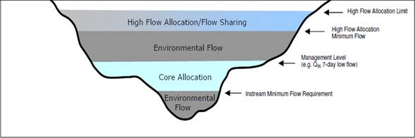
Figure 1; The Idealised River flow
Allocation (Harkness 2010)
11. A
detailed assessment of the Ngaruroro River high flow allocation was undertaken
by MWH in 2010, with the objective of investigating the potential high flow
water allocation to allow water harvesting from the Ngaruroro River, including
particularly during the winter and spring months (June to November when
typically the river flows are higher), and to determine whether there were any
effects on instream values. In conjunction with the hydrological and
ecological analysis, MWH also modelled high flow allocation scenarios to
determine a sustainable flow above which high flow allocation could be made
available without adversely affecting the instream ecology requirements and
flow variability. Some of the more pertinent findings are summarised in the
overview document (attachment 1) and key supporting technical documents[2].
12. The FRE3
statistic is a measure of flow variability, being the number of times per year
the flow exceeds three times the median flow. The FRE3
statistic is a measure of a river’s ability to maintain ecological
(benthic) values by flushing periphyton and turning cobbles. FRE3
incorporates both a frequency and intensity component and its application in
New Zealand rivers has identified correlation with instream biological
variables, such as periphyton and macroinvertebrate community structure.
13. The RRMP
seeks to maintain or improve existing aquatic ecosystems and as such any high
flow allocation regime needs to be set in the context of instream management
objectives. There are three principal components of a flow regime
requirement for ecological values (MfE 1998), namely:
13.1. Flow
variability
13.2. A
minimum flow for water quality
13.3. A
minimum flow for habitat requirements.
14. It was
recommended to the TANK Group that the FRE3 value for the Ngaruroro
River shall not vary from the FRE3 calculated using naturalised flow
by more than 10%. It was determined by Harkness (2010) that 10% limited
the impact on the aquatic environment and was an acceptable threshold.
The cease-take trigger flow for high flow abstraction was proposed to be set at
20 m3/s, to ensure protection of the low flow and reliability of
run-of-river takes.
15. It should
be noted that the council is currently applying an informal high flow
allocation for the Ngaruroro River of 2 m3/s with a trigger flow
equal to the median (20m3/s). Increases will be subject to
contest and demand without clearer policy and rules in the Plan.
16. The
options presented to the TANK Group identified that there were high flow
allocation options that offered suitable water for storage, but which also did
not modify the FRE3 by more than 10%, and therefore were considered
appropriate for maintaining the aquatic ecosystems and hydrological
functioning.
|
High Flow Allocation (l/s)
|
Percentage Change of FRE3 from Zero High Flow
Allocation
|
|
2,000 (existing high flow allocation)
|
1.9%
|
|
4,000 (existing + 2,000)
|
2.3%
|
|
6,000 (existing + 4,000)
|
4.8%
|
|
8,000 (existing + 6,000)
|
6.3%
|
17. As noted above, the purpose of a high flow allocation is to provide
water for storage, so that water may be released or used later when there is
demand or need. In determining what amount of high flow allocation was
deemed appropriate it was important to consider the amount of storage that
could be achieved, whilst still maintaining the instream values for the aquatic
ecosystems. Pickens (2010[3])
considered that potential new irrigation demand for the Heretaunga Plains and
Ngaruroro flats could be in the vicinity of 3,500ha, and that this demand could
be met by 17.5 million cubic metres (Mm3) of storage. The high flow
allocation scenarios were considered in terms of this potential storage
capacity. It should be noted that this potential storage demand was not
intended to predetermine the end use of the stored water but provided context
for what a comparable water demand may equate to in real terms (in
volume).
18. A
modelled analysis of the ability of the proposed high flow allocations to meet
this demand was undertaken and presented to the TANK Group in March 2018[4].
The volume of water available during the winter and spring period June
to September was calculated for each year of the SOURCE simulation from 2015 to
2032. The assumption being that if 17.5 Mm3 of water was available
for harvest during each winter, there would be sufficient to fill the storage
required to meet demand for irrigating 3,500 ha.
19. Of the
options identified it was determined that an additional high flow allocation of
2 m3/s would not be sufficient to satisfy this storage capacity. An
additional allocation of 4 m3/s may be sufficient to fill the
simulated reservoir’s capacity during most, but not all, years of the
simulation. An additional allocation of 6 m3/s (a total of 8,000
l/s) is predicted to be satisfactory for filling 17.5 Mm3 of storage
during all years (2015-2032) of the simulation.
Issues and
uncertainties
20. The TANK
Group agreed in principle to incorporate policy within the draft plan change
which provided the flexibility to permit high flow allocations for water
storage (see policy 51, page 37 of the Draft Plan v7.1.0 August 2018).
However, the TANK Group did not reach consensus with regards to what the high
flow allocation should be limited to.
21. The
modelled results presented to the TANK Group for the high flow allocation
limits were 6 m3/s and 8 m3/s. 4 m3/s
was not considered an option because this would not be sufficient to satisfy
storage capacity. As noted above both the 6 m3/s and 8 m3/s
levels of abstraction would not impact the FRE3 value of the river
by more than 10% (the percentage change from zero high flow allocation was 4.8%
and 6.3% respectively). There was not agreement within the TANK Group
which of these two options was best, and some TANK members advocated that the
full 10% (12 m3/s) should be made available for storage as this
provides for future water demand and remains consistent with the appropriate
threshold for protection of the river ecosystem.
22. To be
clear, nothing in PC9 assumes any specific capital works for high flow storage
reservoirs. References to reservoirs relates to model simulations only
– not real or specific scheme designs.
Summary of Options
23. The
following three options are considered appropriate to meet the potential future
water demands whilst still protecting instream ecological values. It is
recommended that one of the following options be adopted and be incorporated
within Draft Policy 51:
Option A: A
high flow allocation limit of 6 m3/s at 4.8%
Option B: A
high flow allocation limit of 8 m3/s at 6.3%
Option C: A
high flow allocation limit of 12 m3/s at 10%
24. The staff
recommendation is that the RPC adopt Option B – 8 m3/s
high flow allocation. The analysis shows that 8 m3/s can be
taken for storage in the Ngaruroro catchment while also meeting an
environmental threshold for minimising impacts on the range of river flows
needed for efficient and effective functioning of the Ngaruroro River related
to high flow flushing effects. This level of allocation results in
substantially less change to the FRE3 than the 10% threshold (a 6.3%
change).
25. It is
considered that a similar approach should also be adopted for the Tutaekuri
River in order to provide a high flow limit.
26. While
planning staff consider that Option A is also an acceptable option, it does not
however offer the same level of security for future demand as Options B or
C. Whereas Option C offers the most opportunity for water storage, this
is well in excess of the projected demand and has not been considered fully by
the TANK Group. While some members felt that the sustainable amount could be
provided for now, others either preferred to work in stages or to adopt a risk
averse approach to limit new storage.
Reporting Officers’ Recommendation
27. Staff recommend Option B so that the proposed policy would read as
follows:
Policy
51 Takes to Storage
…and
will limit the amount of flow alteration so that the taking of surface water
does not cumulatively affect the frequency of flows above three times the
median flow in the Ngaruroro and Tutaekuri Rivers by more than 6.3% and
provided that
The
high flow take ceases when the river is at or below the median flow;
a) Such
high flow takes do not cumulatively exceed the specified allocation limits;
b) Any
takes to storage existing as at <date of notification> will continue to
be provided for within new allocation limits and subject to existing trigger
flows.
Schedule
7 specifies the limits associated with the damming and take to storage rules
(TANK 11-14) and enables the policy to be implemented.
ISSUE 2 STREAM
DEPLETION MANAGEMENT
Table 2; Outline of non-consensus
issue 2 - management of lowland stream-depletion effects from groundwater
abstraction
|
Issue
|
How flows in lowland streams should be
managed as a result of the stream depletion effects of groundwater takes.
|
|
Options
|
A – Reduction in total groundwater
allocations
B – Restrictions on some/all
groundwater takes at low flow times
C – flow enhancement at low flows
|
|
What Group has agreed
|
§ That an interim
allocation limit for groundwater be adopted
§ that re-allocation is
only on the basis of actual and reasonable use
§ that new water use is
prevented
§ that riparian land
management be improved to provide shading, reduce macrophyte growth, reduce
temperature and increase oxygen
§ that a storage and
release solution be further investigated and developed
|
|
Reporting officers’ recommendation
|
Adopt Policy 35 in version 7 of PC9.
|
Background
28. The new
Heretaunga Plains groundwater model shows that groundwater and surface water
are highly connected across the Heretaunga Plains, with nearly all groundwater
takes connected in varying degrees to surface water systems.
29. These
findings along with full details of the model development, simulations and
scenario modelling are described in technical reports. Some of the more
pertinent findings are provided in more detail in the overview document
(attachment 2) with the technical reports[5]
describing the modelling and supporting these findings separately available.
30. The TANK
Group supported the development of policies that are aimed at managing the
Heretaunga Plains aquifers through a range of mechanisms. While they
generally supported this range of measures, the flow enhancement mitigation
measure was supported by the vast majority of members, but not fully supported
(i.e. not consensus). Nonetheless, the draft Plan Change does contain
policies agreed by the TANK Group that;
30.1. Establish
limits for managing water takes
30.2. Ensure
any reallocation is based on existing use (up to 2017) to reduce the level of
over-allocation (actual and reasonable water use is defined)
30.3. Remedy
the stream depletion effects of groundwater takes by flow enhancement,
30.4. Take
into account the high level of uncertainty around the allocation limit and the
actual level of water use.
30.5. Ensure
the development of other measures, technology and management responses to
meeting the needs of the lowland streams affected by groundwater takes.
30.6. Enable
a staged management approach that allows better information to be
collected. This includes further reduction of the allocation limit should
over-allocation and adverse effects still be an issue.
31. The flow
enhancement management regime and the background to its development is
described in more detail in Attachment 2. The attachment also describes
the management options that were considered and modelled.
32. The
stream flow enhancement measure has been developed for the lowland spring fed
streams that are tributaries of the Karamu River. This was not found to
be an appropriate mechanism for managing the Ngaruroro River flows and so an
alternative storage and flow release option has been developed separately to
address groundwater flow depletion effects on that river.
33. The
significant findings of the modelling exercise are that;
33.1. Surface
water is in a strong hydraulic connection with the Heretaunga Plains aquifer
33.2. The
effects of groundwater pumping on stream depletion are distributed throughout
the Heretaunga aquifer, rather than being confined to small zones
33.3. The
stream depletion is a consequence of a cumulative impact of pumping throughout
the Heretaunga Plains
33.4. Groundwater
pumping has been increasing during last 30 years
33.5. Groundwater
levels and spring flow in Heretaunga Aquifer have declined over several decades
due to increased pumping
33.6. Decline
over last 20 years has been generally small (less than 0.5 metres). Larger
declines in limited area are most likely due to impact of abandoned artificial
recharge scheme
33.7. Water
balance of the aquifer indicates that current pumping does not exceed recharge
and groundwater mining is not occurring
34. Lowland
streams (including the Awanui, Irongate, Louisa Streams) do not meet targets
for water quality, especially for oxygen, temperature and MCI. This means
that the needs of the aquatic ecosystem, mauri and other instream values held
for the lowland streams are not being met by current management.
35. The
stream flows are affected by stream depletion from groundwater during
summer. They are also adversely affected by the high rates of macrophyte
growth. Macropyhte growth, which is a key stressor for the rivers as it
results in extreme oxygen fluctuations as a result of the plant growth and
respiration. Low flows in low gravity streams will also result in low
levels of dissolved oxygen
36. The model
was used to predict effects of changes to the water management regime for
ground and surface water abstraction. The significant findings were;
36.1. If
groundwater pumping remains at current levels, there will be no further decline
of water levels and spring flows.
36.2. If
groundwater pumping continues to increase, there will be significant effects on
water levels, spring flows (including dry streams and rivers) and possibly
saline intrusion issues.
36.3. If
frequency of dry years increases, water levels and spring flows are likely to
remain at low, but stable, levels
Stream flow depletion
37. Stream
flow effects from groundwater takes are not localised and combined abstraction
effects over the wider Heretaunga Plains add to declining water levels and
flows. Every water user has some effect and the effect is cumulative across the
Plains. This represents a big difference in the way the Council and wider
community have understood and managed abstraction to date.
38. The
groundwater and surface water models have been used to explore options for
mitigating the stream depletion effects of groundwater pumping on surface water
bodies. These options are summarised as;
38.1. the
status quo approach to restrictions
38.2. no
irrigation across the modelled area
38.3. using
the same groundwater depletion categories used for the Tukituki Plan change
(PC6).
39. Management
measures that included bans or take restrictions linked to a minimum flow were
not found to be effective measures to restore stream flows in a timely
manner. The restriction would have to be substantial across all takes and
the length of time before a flow improvement was evident was also significant.
40. An
overall reduction in pumping was also modelled. Again this management
measure was not found to be effective or efficient as substantial reductions in
allocation would be needed across all of the existing takes, flow improvements
would be variable and even at a 15% reduction, flow improvements would still
not be significant for some streams.
41. A further
complication was the uncertainty about the actual allocations for each permit
and how a reduction in pumping could be calculated for each consent. Note
that water allocation for the Heretaunga Plains aquifer exceeds approximately
140Mm3per year and the actual use in the 2012/2013 drought has been
modelled as 90 Mm3per year. The total water use as the actual
and reasonable level of pumping remains uncertain until each water permit is
reviewed. That is in part why the allocation limit is an interim limit.
Flow Enhancement
42. Dissolved
oxygen is vital for safeguarding the life-supporting capacity of streams, and
reduced flow can reduce oxygen in low-gradient streams that support high
abundances of aquatic plants. Additionally, high temperatures and low oxygen
were correlated with degraded Macroinvertebrate Community Index scores in
streams of the Heretaunga Plains (Haidekker 2016)[6].
43. Flow is
not the sole determinant of oxygen concentrations. The same flow will produce
less oxygen in streams with a flatter gradient and a larger channel (Wilding
2016)[7].
44. Decreased
water temperatures also reduce the amount of oxygen that fish need to survive.
Riparian shading can maintain cooler temperatures, especially for smaller
channels. Hence, both flow management and riparian management can be applied to
ensure oxygen supply from the water exceeds oxygen demand for fish survival.
45. More oxygen
is required to sustain more sensitive fish and invertebrates. Predictions from
the oxygen-flow modelling indicate that flow management alone could not achieve
the oxygen requirements of the most sensitive species. The intention of a
flow enhancement scheme is that it provides a way to manage the stream
depletion effects of water abstraction and that other riparian land management
initiatives are also important in relation to macrophyte growth management and
shading.
Feasibility of flow
enhancement
46. Modelling
was carried out to determine effects of pumping groundwater to maintain stream
flows. A key objective was to ensure the combined effect of groundwater
abstraction for augmentation would not generate unmanageable stream depletion
effects that would negate the benefits of the augmentation. Other
assessments were carried out to ascertain the economic feasibility for permit
holders.
47. Results
showed that stream depletion could be effectively and economically remedied by
augmentation from groundwater for the modelled streams, except for the stream
depletion effect on the Ngaruroro and Karewarewa Rivers.
48. Flow
enhancement of the Karewarewa is not likely to be effective. The
modelling showed that complete flow restoration of the Karewarewa Stream is not
likely to be possible via augmentation alone. Because of high streambed
conductance (where surface water moves through the stream bed into the
groundwater) in losing reaches, flow enhancement of the Karewarewa Stream is
likely to result in adverse stream depletion effects as a consequence of
groundwater pumping to provide augmentation water. Additional targeted policy
to manage this stream has been included in the draft plan.
49. The
management of the stream depletion effect on the Ngaruroro River flows was
considered in more detail. The groundwater depletion effect
is in the section of the river from Fernhill down to just above confluence with
Tutaekuri/Waimate. This is the section that has variable flow (it is
losing or gaining). Below that there is in-flow from Tutaekuri-Waimate River
which is quite high so the river is no longer so sensitive to
abstraction. High flows would be required to augment the river and they
would have had adverse effect on groundwater levels.
50. The
options considered included;
50.1. Continue
to “live with” stream depletion impact on Ngaruroro River
50.2. Include
the stream depletion effect within the surface water allocation.
50.3. Reduce
total allocations below current pumping levels
50.4. Ban/restrict
all/some takes in all zones at specified flow
50.5. Develop
alternative mitigation option (i.e. water storage and release)
51. The water
harvesting and release mitigation method for managing the river depletion
effects of the Heretaunga Plains groundwater abstractions was found to be a
feasible option and it would depend on the trigger flow used for initiating
flow releases.
52. The draft
Plan Change has therefore included policy direction for further feasibility
assessment of this mitigation measure, including further understanding
environmental, technical and economic effects, and options for funding,
construction and management. The aim of such a scheme is to manage the
stream depletion effects of Heretaunga Plains groundwater abstraction. If
it is found to be not feasible, then the alternative options described above
would need to be revisited. This approach was agreed by the TANK Group.
Issues and
uncertainties
53. A number
of issues have been raised by the TANK Group about the flow enhancement
measures. These are described more fully in attachment 2 and include;
53.1. uncertainty
about the nature and scale of the environmental benefits
In addition to the
feasibility modelling, there are other flow enhancement schemes in operation or
under development that illustrate the potential benefits.
53.2. that
such a measure should be considered as short term only
The flow enhancement
could become a longer term solution provided that upon review it is found to be
effective and efficient. This determination is still subject to further
work including implementation and assessment
53.3. that
reduction in pumping should be a preferred option
This was modelled and
found to be less directly effective and with likely very significant adverse
effects on the socio-economic wellbeing of communities.
53.4. that
flow enhancement does not address the cause of the problem
Not all adverse
effects are required to be avoided. The flow enhancement along with the
riparian land management improvements will both remedy and mitigate adverse
effects and still protect the aquatic ecosystems and provide for community
well-being.
53.5. that
further groundwater abstraction will have adverse effects
Modelling shows that a
limited amount of flow enhancement can be sustained without creating additional
significant adverse effects.
53.6. the
need for community and water permit holders to be involved in successful
management
This was identified as
both an opportunity and a risk.
Summary of Options
54. A number
of management scenarios were assessed or modelled. They included:
54.1. status
quo management
54.2. groundwater
take management on similar basis to that adopted for the Tukituki
54.3. bans
and restrictions when low flows were reached
54.4. reductions
in allocations
54.5. storage
and release for managing the Ngaruroro stream depletion effect
54.6. flow enhancement for lowland streams
54.7. a
combination of water allocation and other measures (an interim allocation
limit, reduce allocations to actual and reasonable, improve riparian land
management and review success of these measures)
55. The
non-consensus has principally been in relation to item 54.6.
Reporting
Officers’ Recommendation
56. That the Committee adopt the TANK plan provisions for flow
enhancement (in existing Policy 35 pg29 of V7), plus associated rules) for
recommendation to the Council.
ISSUE 3: MINIMUM FLOWS AND ALLOCATION LIMITS FOR
THE TUTAEKURI AND NGARURORO RIVERS
Table 3 –
Outline of non-consensus issue 3 – minimum flows and allocation limits
for Ngaruroro and Tutaekuri Rivers
|
Issue
|
What low flow management regime(s) are the
most appropriate to manage the effects of surface water abstraction from the
Ngaruroro and Tutaekuri Rivers.
Are changes required to the RRMP’s
existing minimum flows and allocation limits that manage abstraction from the
Ngaruroro and Tutaekuri Rivers and impose restrictions on abstraction at
times of low flows?
|
|
Options
|
Ngaruroro River
A – Retain existing flow of
2400l/sec, decrease allocation limit to 1300l/sec
B – Staged increase in minimum flow to 3600l/sec
by 2035. Either decrease allocation limit or allocate existing use with
lower security of supply
Tutaekuri River
A – Retain minimum flow of 2000l/sec
and reduce allocation to 1140l/sec
B - Increase minimum flow to 2500l/sec and
reduce allocation to 1140l/sec
C - Staged increase in minimum flow to 3200l/sec by
2030. Either decrease allocation limit or allocate existing use with
lower security of supply
|
|
What Group has agreed
|
§ Establish interim
allocation limits for the Heretaunga aquifer based on existing levels of
water use.
§ Establish allocation
limits for surface takes, including zone 1 groundwater.
§ policies to manage
over-allocation
§ policies and rules to
improve aquatic ecosystem health
|
|
Reporting officers’ recommendation
|
Ngaruroro River – Option A.
Tutaekuri River – Option B.
|
57. The TANK Group supported the establishment of interim allocation
limits for the Heretaunga aquifer based on existing levels of water use.
This will limit the potential for further reductions of flow in the Ngaruroro
River. The Group also agreed on a range of measures designed to improve
aquatic ecosystem habitat and water quality in the Ngaruroro and its
tributaries.
58. However,
there was non-consensus about the flow management regimes required to manage
the effects of surface water abstraction for both the Tutaekuri and Ngaruroro
Rivers.
59. One of
the more significant non-consensus issues was around whether changes were
needed to the minimum flow regime for the Ngaruroro and Tūtaekurī
Rivers. This report summarises the key information that was considered by
the TANK Group. The information is provided in more detail in attachment
3 to this report and in the technical reports[8]
supporting this work.
60. The
Regional Resource Management Plan (RRMP) contains minimum flows and allocation
limits that manage the abstraction of water from the Ngaruroro and
Tūtaekurī Rivers and impose restrictions on abstraction at times of
low flows. These were introduced in the RRMP in 2000.
61. TANK
Group did not specifically review the effectiveness of those provisions in
meeting desired outcomes, but instead looked at the range of values that those
water bodies have and considered the appropriateness of minimum flows in light
of all of the identified values in a ‘from new’ approach.
62. The
National Policy Statement for Freshwater Management (NPSFM) requires that the
life-sustaining capacity, ecosystem processes and indigenous species of
freshwater is safeguarded. It also requires that communities are enabled
to provide for their economic well-being, including productive economic
opportunities, in sustainably managing freshwater quantity, within limits.
63. The TANK
Group supported capping water allocation from the Heretaunga aquifer at
existing levels, and this will limit the potential for further reductions of
flow in the Ngaruroro River as a result of stream depleting groundwater takes.
The Group was unable to agree on whether changes were necessary to the minimum
flow regimes or the associated allocation limits and in particular whether the
minimum flows should be increased.
64. However,
a range of provisions have been developed by the TANK Group to improve the
management of land and freshwater within the TANK catchments that are relevant
to the maintenance or improvement of mauri and aquatic ecosystem health of the
two rivers. Those measures serve to illustrate that river and aquatic
ecosystem health, especially in such a diverse landscape, does not depend
solely on trigger flows for rationing abstraction.
65. The TANK
Group has included measures in relation to ;
65.1. damming
prohibition on the mainstems, and a small number of named tributaries.
65.2. targets
for the reduction in a number of key contaminants including dissolved nutrient
and sediment in the mainstem and the tributaries. This will have the flow
on effect of improving MCI scores for the rivers and contributing to the health
of the connected Waitangi Estuary.
65.3. widespread
improvement of riparian land management across the catchment and including
stock exclusion.
65.4. acknowledgement
of the stream depletion effects of groundwater takes on the Ngaruroro River and
new policy direction to explore measures to reduce this impact.
65.5. reduced
allowance for permitted activities to reflect the full and some cases over-allocation
of the groundwater surface resources linked to the main rivers.
65.6. reducing
allocation of water to prevent further depletion of river flows.
65.7. flow
enhancement measures to remedy the effects of stream depletion.
66. In
deciding when to limit water use, the TANK group considered the effect of
reduced water flow on critical (instream) values. Critical values are those
values that are most sensitive to reduced flows.
67. For both
the Ngaruroro and the Tutaekuri Rivers, the TANK Group have identified a range
of instream values for the rivers that include;
67.1. tikanga
Māori values including those for cultural practices
67.2. habitat
for native fish and birds
67.3. recreational
activities including trout fishing, swimming and boating
67.4. trout
habitat.
68. The TANK
plan objectives include improvement in the lower reaches and tributaries, where
necessary, to support healthy ecosystems including native fish (among other
things). Areas where improvement in freshwater quality is necessary are
identified through the attribute states specified in the draft Plan Change.
69. Of all of
the identified values, the most flow demanding values for each river are
torrent fish and trout for the Ngaruroro and Tutaekuri rivers
respectively. If these fish are provided for, then other less flow
demanding species will consequently also be protected as their flow
requirements are less. It is assumed that mana whenua, cultural and
recreational values will also be accommodated within this ecological flow
(although there are no guidelines that enable a quantitative assessment).
Jet boating is less concerned with the minimum flow regime than it is with
ensuring the braided reaches continue to be maintained, including as a result
of any water damming or storage activities.
70. Minimum
flow does not dictate river flows or halt flow recession. Also critical is how
much water is being abstracted and how these two management levers interact and
influence river health. It is the combination of the allocation limit as
well as a minimum flow that triggers restrictions in water abstraction that are
used to manage adverse effects of abstraction on river flows. The
recovery of river flows, as a consequence of triggering restrictions in
existing takes, is most effective at the lowest river flows. Raising the
trigger flow substantially offers diminishing benefit for river flows because
the flow depletion effect of those linked takes is relatively small at higher
flows.
71. There are
several reports and assessments relevant to the decision making for trigger
flows for managing the effect of surface abstraction on river flows.
71.1. economic,
social and cultural impacts of imposing take restrictions on the ecosystem
attributes for flow
71.2. the
assessment of the appropriate flow requirements for the identified river values
of the Ngaruroro River and the conclusions of the WCO applicants.
71.3. other
management decisions made to improve aquatic ecosystems and meet objectives for
freshwater (and the estuaries) including new abstraction limits where none
existed previously.
71.4. the
comprehensive implementation plan demonstrating stakeholder commitments.
Fish Communities
72. There are
existing highly valued native fish in both the Ngaruroro and Tutaekuri Rivers
that indicate the suitability of the flow management regime for instream
values. There is limited data available about the state and trends of the
native fishery, except that there is general agreement that an important native
fishery is present. The Council has recently undertaken additional fish
surveys to gather more information.
73. In the
Tūtaekurī River, trout are the most flow demanding species. In
addition to native fish, the Tūtaekurī River and some of its
tributaries are valued for recreational trout fishing. Habitat surveys focused
on the mid-reaches of the Tutaekuri River where trout are plentiful, with
earlier habitat surveys indicating similar habitat levels downstream of the
Mangaone Stream confluence where notable populations of native fish can be
found (e.g. freshwater flounder).
Existing water
allocation and use
74. There are
some shortcomings with the current allocation regime that require
addressing. The RRMP currently has a minimum flow for the Ngaruroro River
at Fernhill of 2400 litres per second (l/sec) and an allocation limit of
956,189 cubic meters per week (m3/week). This equates to (1581
l/sec). Changes to how groundwater takes with a direct effect on surface
flow (referred to as the Zone 1 groundwater takes) are managed has also
resulted in the amount of water allocated from the river now being calculated
as 3033 l/sec. This means that even with no changes to the minimum flow
the river is already being managed as an over-allocated river and water
allocation will need to be significantly reduced to phase out this
over-allocation.
75. The new
modelling has also shown a significant stream depletion effect on the river
from the cumulative impact of Heretaunga plains groundwater abstraction.
The amount of stream depletion in Ngaruroro River (including variable loss
section below Fernhill) can be up to about 1200 l/sec in a dry year (2012-2013
summer) and is on average about 750 l/sec during the summer. The
mitigation of this stream depletion effect is proposed to be by a water storage
and release scheme, possibly based on extending the storage provided by a water
storage lake at Te Tua (refer policy 38).
76. The large
over-allocation implies the river would dry up completely in dry years. The
reason we do not see drying in practice (except 1983) is people rarely use
their full consented allocation. In addition, people use water at different
times, depending on the timing of peak demand by different land uses (e.g.
onions, apples, grapes). One of the first steps in managing over-allocation
will be in narrowing the gap between consented allocation and actual use.
Using Models
77. The
RHYHABSIM model was used to provide information about the flow and habitat
requirements of fish. Historical data was also used to help understand
potential level of effect on water bodies and flows. RHYHABSIM and
historical flow data is provided for both rivers in attachment 3. The
ground and surface water models were used to predict what happens to river
flows, changes to the number of days at or below minimum flows and the
consequential impacts on security of supply for abstraction.
78. The impact
of allowing for ongoing abstraction of 10% of the amount authorised by a water
permit has also been modelled. This may be a management response
79. This
information is summarised in attachment 3 and is also more fully reported in
supporting science reports[9].
80. The
social, cultural and economic impacts of changes to the existing water
allocation have been modelled or assessed. The results of these
assessments are separately reported[10]
and summarised in attachment 3.
Impacts of Change;
81. The social
and cultural impact assessment (SCIA) included the following strands of work.
81.1. An
assessment of TANK community perceptions, questions and feedback about the
current TANK draft plan
81.2. A
statistical assessment of TANK community, social and cultural effects that can
likely be anticipated as a natural consequence of implementing a future TANK
plan
81.3. An
assessment of TANK Māori community, social and cultural effects that can
likely be anticipated as a natural consequence of implementing a future TANK
plan
82. The
assessment described the inter-generational inequities associated with land
alienation and the intra-generational inequities that have developed through
the allocation and distribution of financial resources, jobs, homes and
well-being needs of the whānau Kahungunu ki te Heretaunga.
83. The
assessment concluded that the draft Plan Change would result in flows of
ecological, social and cultural benefits to the TANK communities.
However, there is a high likelihood of cultural, social and financial harm to
some communities with the adoption of the changes to the minimum flow regimes
evaluated by Agfirst, Nimmo-Bell and MEL.
84. In
particular TANK catchment communities characterised by high levels of welfare
dependency or by high levels of Māori will be at risk.
85. Timeframes
for implementation and any effects on regional GDP should be specifically
addressed within any plan change.
Economic Assessment
86. The
assessment carried out by Agfirst, Nimmo-Bell and Market Economics found that
changes to security of supply for irrigation of horticultural crops through
increases to minimum flows or decreases in allocations would have a significant
impact on the regional economy.
Flow Management Options
87. The
outcomes being sought by various stakeholders have been moderated as a
consequence of the TANK Group member discussions. However, there is still a
considerable gap in the outcomes sought by the various stakeholder
groups. There is no clear majority preference for either of the two
options which are explained in more detail in the attachment 3
88. The
extent of non-consensus at the conclusion of the TANK Group meetings is
illustrated in the following table;
|
Option A
|
Option B
|
|
Minimum Flow for Ngaruroro R. at Fernhill
|
Remains at 2400l/sec
|
Step 1.
As at PC9 Notification; 2400l/sec
Step 2
2025 increase to 2800l/sec
Step 3
2030 increase to 3200l/sec
Step 4
2035 increase to 3600l/sec
|
|
|
|
Note that new minimum applies at time a water permit
is applied for or, if as a result of a requirement to review an existing
water permit, at the specified date provided the plan is operative by then.
|
|
Water storage
|
Council is committed to investigation/ development
of storage options to provide for low flow enhancement as the resolution of
the river depletion effect from the g/w takes in the HPGMZ
|
Council is committed to investigation/ development
of storage options to provide for low flow enhancement as the resolution of
the river depletion effect from the g/w takes in the HPGMZ
|
|
|
Refer policy 53
|
|
Allocation Limit
|
Target allocation limit of 1300 l/sec (down from
1580 l/sec)
(existing allocation is now over 3000 l/s because of
new accounting for Zone 1 groundwater takes)
|
Either
Allocation limit[11] decreases at each step on a pro rata
basis across all consents so that the following allocation limits can be met:
Step 1
As at PC9 Notification; actual and reasonable
Step 2
2025 reduce to 1181 l/sec (25% reduction)
Step 3
2030 reduce to 781 l/sec (50% reduction)
Step 4
2035 reduce to 381 l/sec (75% reduction)
|
Or
Water is allocated on actual and reasonable use
basis and permit holder subject to a lower security of supply with the higher
minimum flow
|
|
|
To be reflected in policy 40 and schedule
6
|
|
|
|
Note in order to carry out pro rata reduction, all
water permits would need to be called in and reallocated before required
pro-rata reduction amount is calculated.
|
|
Water Permit Allocation Management
|
Re-allocation of surface water will be on the basis
of historic actual and reasonable water use. A sinking lid approach
will be adopted to ensure ongoing reductions in allocation
|
As above
|
|
|
To be reflected in policy 40 and schedule
6
|
|
Emergency water takes
|
Not provided for
|
10% of the allocation limit can continue to be
abstracted after the minimum flow is reached
|
89. There are costs and benefits associated with both these options
which are summarised as follows.
The reasons supporting Option A;
|
The costs or risks with Option A;
|
|
The existing flow regime means reduced adverse
impacts on social and economic well-being.
There is little evidence that the existing flow
regime is causing adverse effects on native fish.
|
Uncertainty that any storage flow enhancement
solution to address stream depletion effects from Heretaunga Plains
groundwater abstraction will be developed in a timely manner – despite
the stated phase in dates and policy commitment.
|
|
The associated measures adopted to improving
ecosystem habitat are less disruptive to communities and can be introduced in
a staged cost effective manner,
|
A reduction in abstraction limit and potential
adverse impacts on economic well-being of existing permit holders.
|
|
This approach complements measures being developed to
manage the stream depletion effects of the groundwater takes in the
Heretaunga Plains Water Management Unit (HPWMU)
|
A relatively high level of over-allocation needs to
be phased out. (Actual use is likely to be significantly less than
allocated use)
|
|
Social equity and impacts on Māori cultural
values and uses are also able to be addressed by high flow water reservation
measures
|
Lack of information about current state and trends of
indigenous species
|
|
The allocation limit (compared to MALF) is reduced to
more environmentally conservative levels.
|
|
|
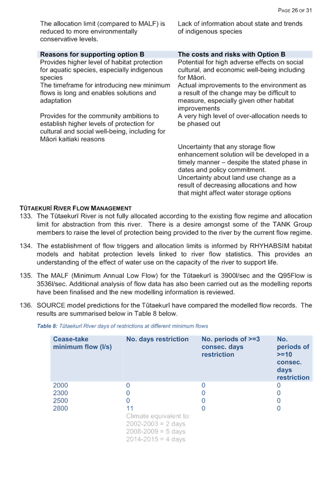
Reasons for supporting option B
|
The costs and risks with Option B
|
|
Provides higher level of habitat protection for
aquatic species, especially indigenous species
|
Potential for very significant adverse effects on
social cultural, and economic well-being including for Māori.
|
|
The timeframe for introducing new minimum flows is
long and enables solutions and adaptation
|
Actual improvements to the environment as a result of
the change may be difficult to measure, especially given other habitat improvements
|
|
Provides for the community ambitions to establish
higher levels of protection for cultural and social well-being, including for
Māori kaitiaki reasons
|
A very high level of over-allocation needs to be
phased out
|
|
|
Uncertainty that any storage flow enhancement
solution to address stream depletion effects from Heretaunga Plains
groundwater abstraction will be developed in a timely manner – despite
the stated phase in dates and policy commitment.
|
|
|
Uncertainty about land use change as a result of decreasing
allocations and how that might affect water storage options
|
Reporting
Officers’ Recommendation
90. That the committee adopt Option A for Ngaruroro River flow
management and allocation for recommendation to the Council.
Tūtaekurī
River
91. The
Tūtaekurī River is not fully allocated according to the existing flow
regime and allocation limit for abstraction from this river. In response
to the desire by some of the TANK Group to raise the level of protection being
provided to the river by the current flow regime, the impact a number of higher
flow triggers was modelled.
92. Detailed
investigation of trout habitat use in the Tutaekuri River revealed that the
existing minimum flow of 2000 l/s (at Puketapu) does not provide a high level
of protection for the habitat of rainbow trout. Increasing the minimum flow
from 2000 l/s to 2500 l/s would increase the level of habitat protection from
65% to 75%, without making any appreciable difference to the security of supply
for existing water users.
93. The range
of non-consensus about management options preferred for the Tūtaekurī
River is illustrated in the following table.
|
Option A
|
Option B
|
Option C
|
|
Minimum Flow for Tutaekuri River at Puketapu
|
Remains at 2000 l/sec
|
Increase to 2500 l/sec
|
Step 1.
As at PC9 Notification; 2500l/sec
Step 2
2025 increase to 2800l/sec
Step 3
2030 increase to 3200l/sec
|
|
|
|
|
|
Note that new minimum flows apply at time a water
permit is applied for or, if as a result of a requirement to review an existing
water permit, at the specified date provided the plan is operative by then
|
|
Allocation Limit
|
Target allocation limit of 1140 l/sec (down from
current limit at 1536l/sec)
(a 25% reduction)
|
Target allocation limit of 1140 l/sec (down from
current limit at 1536l/sec)
(a 25% reduction)
|
Either
Allocation limit[12] decreases at each step on a pro rata
basis across all water permits so that the following allocation limits can be
met:
Step 1
As at PC9 Notification; actual and reasonable
Step 2
2025 reduce to 736 l/sec (52% reduction)
Step 3
2030 reduce to 336 l/sec (78% reduction)
|
Or
Water is allocated on actual and reasonable use
basis and permit holder subject to a lower security of supply with the higher
minimum flow
|
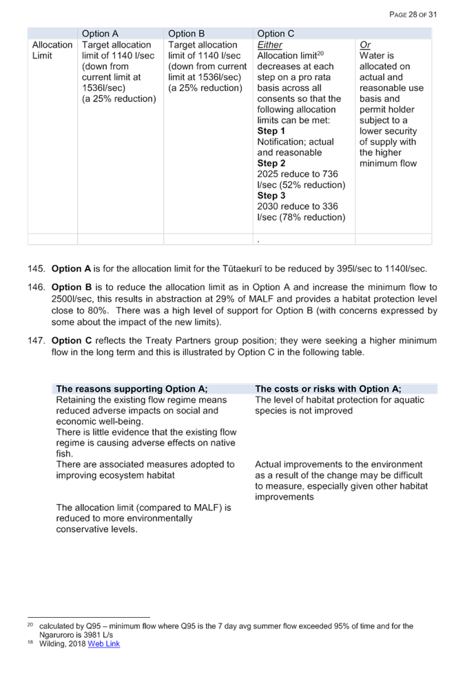
|
Reasons for supporting option A
|
The costs and risks with Option A
|
|
Retaining the existing flow regime means reduced
adverse impacts on social and economic well-being.
There is little evidence that the existing flow
regime is causing adverse effects on native fish.
|
The level of habitat protection for aquatic species
is not improved
|
|
There are associated measures adopted to improving
ecosystem habitat
|
Actual improvements to the environment as a result of
the change may be difficult to measure, especially given other habitat
improvements
|
|
The allocation limit (compared to MALF) is reduced to
more environmentally conservative levels.
|
Does not reflect kaitiakitanga aspirations of mana
whenua
|
|
Reasons for supporting option B
|
The costs and risks with Option B
|
|
Provides higher level of habitat protection for
aquatic species, especially indigenous species
|
A relatively high level of over-allocation needs to
be phased out. (Actual use is likely to be significantly less than
allocated use)
|
|
The higher minimum flow has minor impact on security
of supply for existing users
|
Actual improvements to the environment as a result of
the change may be difficult to measure, especially given other habitat
improvements
|
|
There are associated measures adopted to improving
ecosystem habitat
|
A reduction in abstraction limit has potential
adverse impacts on well-being of existing permit holders
|
|
Reasons for supporting option C
|
The costs and risks with Option C
|
|
Provides higher level of habitat protection for
aquatic species, especially indigenous species
|
Potential for high adverse effects on social
cultural, and economic well-being including for Māori.
|
|
The timeframe for introducing new minimum flows is
quite long and enables solutions and adaptation
|
Actual improvements to the environment as a result of
the change may be difficult to measure, especially given other habitat
improvements
|
|
Provides for the community ambitions to establish
higher levels of protection for cultural and social well-being, including for
Māori kaitiaki reasons
|
A very high level of over-allocation needs to be
phased out
|
|
There are associated measures adopted to improving
ecosystem habitat
|
A reduction in abstraction limit and potential
adverse impacts on economic well-being of existing permit holders.
|
|
|
Uncertainty about land use change as a result of decreasing
allocations and how that might affect water storage options
|
Reporting Officers’ Recommendation
94. That the committee adopt Option B for Tūtaekurī River flow
management and allocation for recommendation to the Council.
Decision Making Process
95. Council
is required to make every decision in accordance with the requirements of the
Local Government Act 2002 (the Act). Staff have assessed the requirements
in relation to this item and have concluded that if the Committee were indeed
to make a decision similar to those being recommended by the authors, then:
95.1. The decision does not
significantly alter the service provision or affect a strategic asset.
95.2. The use of the special
consultative procedure is not prescribed by legislation.
95.3. The decision does not
fall within the definition of Council’s policy on significance.
95.4. The persons affected by
this decision all persons with an interest in the region’s management of
natural and physical resources under the RMA, particularly land and freshwater
resources in the TANK catchment area.
95.5. Staff have considered a
number of different approaches to the three non-consensus issues discussed in
this report.
95.6. The decision is not
inconsistent with an existing policy or plan.
95.7. Given the nature and
significance of the issue to be considered and decided, and also the persons
likely to be affected by, or have an interest in the decisions made, Council
can exercise its discretion and make a decision without consulting directly
with the community or others having an interest in the decision. Once a
plan change is publicly notified, any person may make a submission on that plan
change.
96. Note that the Committee
will be provided with further briefing reports about options and timeframes for
further steps in this Plan Change process. This will include options for
further consultation on a draft and notification of the Proposed Plan Change.
|
Recommendations
1. That
the Regional Planning Committee receives and notes
the “TANK Plan Change Further Information” staff
report.
2. That the
Regional Planning Committee adopts the following provisions to be included
into the draft TANK Plan Change (PC9) Version 8.
2.1 Include
a high flow allocation limit of 8 m3/s for the Ngaruroro River,
and an equivalent high flow allocation for the Tutaekuri River as in Policy
51 and schedule 7 and associated rules.
2.2 Provide
for stream flow enhancement of lowland streams as in Policy 35 and associated
rules.
2.3 Maintain
the RRMP’s existing minimum flow trigger for the Ngaruroro River at
Fernhill of 2400 l/sec and reduce the allocation limit to
1300 l/sec for surface and zone 1 groundwater abstraction in Policy 39
and associated rules.
2.4 Increase
the existing minimum flow for the Tutaekuri River at Puketapu to
2500 l/sec and reduce the allocation limit to 1140 l/sec for
surface and zone 1 groundwater abstraction from in Policy 39 and associated
rules.
|
Authored by:
|
Mary-Anne
Baker
Senior Planner
|
Ceri Edmonds
Senior Planner
|
|
Gavin Ide
Manager Policy and Planning
|
|
Approved by:
|
Tom Skerman
Group Manager Strategic Planning
|
|
Attachment/s
|
⇩1
|
High flow
allocation limits for Ngaruroro and Tutaekuri Rivers
|
|
|
|
⇩2
|
Managing
stream depletion effects by groundwater abstraction
|
|
|
|
⇩3
|
Minimum flow
limits for Ngaruroro and Tutaekuri rivers
|
|
|
|
⇩4
|
Minimum Flows
Report Appendix 2
|
|
|