Meeting of the
Environment and Integrated Catchments Committee
Date: Wednesday 21 September 2022
Time: 9.00am
|
Venue:
|
Central
Hawke’s Bay District Council
28/32 Ruataniwha Street
Waipawa
|
Agenda
Item Title Page
1. Welcome/Karakia/Notices/Apologies
2. Conflict
of Interest Declarations
3. Confirmation of Minutes of
the Environment and Integrated Catchments Committee held on 6 July 2022
4. Follow-ups
from previous Environment and Integrated Catchments Committee meetings 3
5. Call
for Minor Items Not on the Agenda 7
Decision
Items
14. Biosecurity
Operational Plan and Annual Report – Late item to follow
6. Central
Hawke's Bay Tukituki swing bridge funding options 9
Information
or Performance Monitoring
7. Organisational
Ecology by Dr Edgar Burns 15
8. Riparian
margin survey results from Tukituki catchment 17
9. Farm
Environmental Management Plan (FEMP) update 21
10. Environmental
Enhancement programmes 25
11. IRG
programme delivery to date and next steps 31
12. Napier
Meeanee Scheme Review – progress update 39
13. Discussion
of Minor Items not on the Agenda 41
HAWKE’S BAY REGIONAL COUNCIL
Environment and Integrated Catchments Committee
Wednesday
21 September 2022
Subject: Follow-ups from previous Environment and Integrated Catchments
Committee meetings
Reason for Report
1. In the attached list are
items raised at previous Environment and Integrated Catchments Committee
meetings that staff have followed up on. All items indicate who is responsible
for follow up, and a brief status comment. Once the items have been reported to
the Committee they will be removed from the list.
Decision Making Process
2. Staff have assessed the
requirements of the Local Government Act 2002 in relation to this item and have
concluded that, as this report is for information only, the decision-making
provisions do not apply.
Recommendation
That the Environment and
Integrated Catchments Committee receives and notes the Follow-ups from
previous Environment and Integrated Catchments Committee meetings.
Authored by:
|
Annelie Roets
Governance
Advisor
|
|
Approved by:
|
Chris Dolley
Group
Manager Asset Management
|
Iain Maxwell
Group
Manager Integrated Catchment Management
|
Attachment/s
|
1⇩
|
Followups for Sept 2022 EICC mtg
|
|
|
|
Followups for Sept 2022 EICC mtg
|
Attachment
1
|
HAWKE’S
BAY REGIONAL COUNCIL
Environment and Integrated Catchments Committee
Wednesday
21 September 2022
Subject: Call for Minor Items Not on the Agenda
Reason
for Report
1. This item provides the
means for committee members to raise minor matters relating to the general business of
the meeting
they wish to bring to the attention of the meeting.
2. Hawke’s Bay Regional
Council standing order 9.13
states:
2.1. “A meeting may discuss an item that is
not on the agenda only if it is a minor matter relating to the general business
of the meeting and the Chairperson explains at the beginning of the public part
of the meeting that the item will be discussed. However, the meeting may not
make a resolution, decision, or recommendation about the item, except to refer
it to a subsequent meeting for further discussion.”
Recommendations
That the Environment and Integrated
Catchments Committee accepts the following Minor items not on the Agenda
for discussion as item 13:
|
Annelie
Roets
Governance
Advisor
|
James
Palmer
Chief
Executive
|
HAWKE’S
BAY REGIONAL COUNCIL
Environment and Integrated Catchments Committee
Wednesday
21 September 2022
Subject: Central Hawke's Bay Tukituki swing bridge funding options
Reason
for Report
1. This item seeks the Committee’s
recommendation to the Regional Council for the funding source, dollar amount
and transfer of funding from Regional Council to Central Hawke’s Bay
District Council (CHBDC) for the rebuild of the Tarewa Swing Bridge (Waipukurau)
which was damaged beyond repair in the March 2022 flood event.
Officers’
Recommendation(s)
2. Regional Council staff recommend that
the Committee approves the funding of $565,000 total (Source: $23,632 from
Upper Tukituki Depreciation Reserve and $541,368 from the General Disaster
Relief Reserve) and provide this as a grant to Central Hawke’s Bay
District Council to contribute towards the rebuild Tarewa Swing Bridge, with a
legal instrument to guarantee public access across the bridge remains in perpetuity.
Executive
Summary
3. The Regional Council owned Tarewa
Swing Bridge (Waipukurau) was damaged beyond repair in the March 2022 flood
event. Due to Regional Council’s insurance structure, no insurance claim
was able to be made, therefore funding for the construction of a replacement
bridge needs to come from one of Regional Council reserves. The cost to
construct a replacement the bridge has increased significantly compared to the
original bridge.
4. During the early stages of developing
concept designs, Central Hawke’s Bay District Council (CHBDC) proposed to
collaborate with Regional Council for the replacement bridge, requesting the
bridge be designed and constructed with dual purpose, also being capable of
supporting a wastewater pipeline, which is planned for year 8 of their
2021-2031 long term plan. For this to be a viable option for CHBDC,
Hawke’s Bay Regional Council would need to contribute $565,000 (expected
construction cost of a replacement bridge) as a grant. CHBDC would then lead
the design and construction of the bridge and become the owner of the asset
being solely responsible for ongoing maintenance, with the understanding
pedestrian access of the bridge will remain in perpetuity. The total estimated
construction cost of the dual-purpose bridge is $1.1m. Additional costs for the
pipework itself and other project costs equate to approximately $500k.
Background
/Discussion
Original Bridge
5. In 2014, the Rotary Rivers Pathway
Trust together with Regional Council completed the construction of the two
pathways along the Tukituki Awa in the vicinity of Waipukurau. These are
part of the Tukituki Trails network, which is administered and maintained by
the Rotary River Pathways Trust.
6. The Rotary Rivers Pathway Trust
started planning process for a swing bridge to connect the two limestone paths
on either side of the river. They engaged Abseil Access to design the swing
bridge.
7. The Trust believed that it could raise
the funds necessary to construct the bridge and at least one potential funder
required the bridge to be ‘owned’ by a public body, with that body
taking responsibility for its ongoing maintenance. The Trust approached HBRC to
be the ‘owner’ of the bridge and to take responsibility for the
ongoing maintenance and ultimate replacement at the end of its useful life.
8. This was proposed to Council on 30
November 2016 with the following resolution
8.1. ‘’That Council: …
2. Agrees to be ‘owner’ of the proposed bridge, and accordingly
take responsibility for its ongoing maintenance and ultimate replacement; and
accordingly requesting staff to include financial provision for this into
future Annual and Long Term plans’.
9. In 2017 Regional Council, together
with Rotary Rivers Pathway Trust, completed the construction of the structure
called Tarewa Swing Bridge.
10. Since its construction, the bridge had
become the centrepiece of the Tukituki Trails network and was well used and
enjoyed by Central Hawke’s Bay public and visitors.
11. The original bridge had a book value
as an insured Regional Council asset of approximately $343,500 (June 2021:
$312,282 + 2022 CPI Civil Construction 10%). It was recorded as an asset of the
Upper Tukituki Flood Control Scheme (geographically) but is managed as an Open
Spaces asset.
12. The bridge and the associated Tukituki
Trails network are not part of the Great Ride cycleway network in the
Heretaunga Plains area.
March 2022
Flooding Event
13. The bridge was damaged beyond repair
in the March 2022 flooding event. Regional Council’s Works Group has
since dismantled and removed the remains of the damaged bridge, to make the
area safe and open to the public, albeit without the connection across the
river. Materials from the bridge that were able to be salvaged were recovered
by Rotary Pathways and HBRC staff.
14. The bridge was on the asset register
and insured, but the overall cost of the damage from the March 2022 flood event
came under the minimum excess, therefore no claim was made. This scenario
requires replacement funding from reserves.
Rebuild
Planning
15. A significant amount of urgency for
the rebuild has been conveyed by key stakeholders to the contractors and
project team (HBRC and CHBDC), speaking to the significant importance this
structure has to the community.
16. Shortly after the March 2022 flood
event, HBRC started discussions with Abseil Access (the original designer and
builder of the bridge) to develop concept designs and indicative costing of a
replacement swing bridge.
16.1. Part of the design requirement was to
raise the swing bridge height to above 1 in a 100-year flood event, increasing
the structure’s resilience and lowering the likelihood of a new structure
being damaged from future flooding events.
16.2. The increased height meant the
existing location was no longer suitable, due to spatial restrictions from the
true left stopbank and neighbouring property boundary.
16.3. The concept design location was
approximately 30 metres upstream.
16.4. The indicative cost provided by Abseil
Access based on an approximately 89 metre bridge span ($5,000 per metre) and a
60-metre boardwalk ($2,000 per metre), was $565,000.
16.5. These indicative costings are for the
construction only, and do not include finalised design drawings, HBRC officers
time and any consent requirements (both building consent from CHBDC and
resource consent from the Hawke’s Bay Regional Council).
16.6. Significant inflation of the cost of
construction materials and increased height of the bridge are the driving
forces behind the increase compared to the book value and construction cost of
the original bridge.
Central
Hawke’s Bay District Council Partnership Opportunity
17. In Year 8 of the CHBDC 2021 -2031 Long
Term Plan, CHBDC had planned to commence building a wastewater pipeline from
Waipukurau to Waipawa, which requires crossing of the Tukituki Awa.
18. During the early stages of engagement
with Abseil Access, CHBDC proposed to partner with HBRC for the rebuild of the
bridge to align work programmes by building a bridge capable of supporting
their future wastewater asset river crossing requirement.
19. Abseil Access indicated it was
possible to design the swing bridge to withstand the additional load
requirements and, through CHBDC consultation with their technical advisors,
they have decided it is feasible to design a bridge with sufficient resilience
in terms of flooding risk.
20. The increased dual purpose design
requirements will substantially increase the design and construction cost.
21. CHBDC have sought and received
approval to bring funding forward in their Long Term Plan to contribute to the
construction of the bridge, with the assumption HBRC provides a $565,000 grant.
This will enable the bridge to be designed and constructed to accept the
planned future wastewater pipe/s.
22. Due to the increased risk and
significance of the wastewater asset, CHBDC would lead the design and
construction of the bridge and become the owner of the asset, being solely
responsible for ongoing maintenance, with the understanding pedestrian access
across the bridge will remain in perpetuity.
23. HBRC through its consenting function
would need to approve the proposed engineering design from a river
control/flood management perspective. HBRC support would need to be evidenced
in the application for easements to Department of Conservation (DOC). These
approvals would all be sought in advance of the bridge works commencing.
24. The bridge was recorded as an Upper
Tukituki Scheme asset by virtue of geographic location at the time of entering
the asset register as there was no Open Spaces asset class separation at that
time. It has no flood control value, and the replacement funding should be
sourced from general disaster reserves, given the wider community benefit of
the asset.
Funding
Options and Financial
Implications
|
Funding
source
|
Available
|
Impact/comment
|
|
Upper Tukituki Scheme
|
Yes
|
There
is no flood control benefit from the structure, so it is not an equitable
source of replacement finance. There are scheme reserves available, but it
would be a non-beneficial investment to the scheme and costs should not be
limited to this scheme. Reserves for the bridge specifically are limited in
scheme so the impact would be on the wider scheme with no flood control
benefit.
|
|
General Disaster Relief Reserve
|
Yes-
Review required
|
The
insurance excess ($M1.5) requires HBRC to cover these types of events from
disaster reserves. In saying this, spending $565k from the disaster reserve
could mean the balance is below that required for any repair of flood
protection assets after future flood events. Consideration in the next Long
Term Plan (LTP) is how we build up the general disaster relief reserve again
and what an appropriate top level for it should be.
|
|
Open
Spaces
|
No
reserves but could be loan funded (repaid over 10 years)
|
98%
funded through general rates. The wider community benefits would be better
reflected in regional sourced funding as it is not a flood protection
asset.
|
|
Combination Upper Tukituki Depreciation
Reserve and General Disaster Relief Reserve
|
Yes
|
Suggested
ratio is the depreciation value for the bridge since 2017 from the Upper
Tukituki Depreciation Reserve (calculated as $23,632) and the balance from
the General Disaster Relief Reserve
|
|
Pursue
External Funding avenues
|
TBC
|
There
is a push to get the construction of the bridge underway as quickly as
possible which limits potential for sourcing external funding from interested
funders.
There
is no guarantee that the funders who have already provided funding to the
original project will be able to or be willing to support additional
funding. This option could be pursued by CHBDC.
|
|
Do not fund the rebuild
|
N/A
|
Not
considered a viable alternative based on strong community interest and
demonstrated commitment to the original project.
|
Rebuild
options
Option 1 – Regional Council provide $565,000 grant
(maximum) to CHBDC to build a replacement bridge
25. CHBDC would lead the construction of
the dual-purpose bridge.
26. CHBDC proposed ownership structure of
the dual-purpose bridge, maintenance and insurance will be a CHBDC parks
activity, with an easement/access agreement back to 3 Waters.
27. HBRC would remain a key stakeholder
and be consulted on the progress and decisions of the swing bridge design and
construction regularly. HBRC will maintain existing regional cycleways
advisory support, and co-ordination with river and cycleway scheme operational
activity.
28. The understanding between HBRC and
CHBDC is the public pedestrian use of the bridge remains in perpetuity, legal
instruments (e.g. a memorandum of understanding) will be put in place to ensure
this happens. This is also in the interest of CHBDC.
29. Collaboration on this project will
strengthen HBRC’s relationship with CHBDC. There has been good post-flood
co-operation between the two councils on other flood damage remediation (CHBDC
stopbanks and water intakes) following this.
30. The cost of all future life cycle,
maintenance, and replacement activity for the dual-purpose bridge option rests
with CHBDC.
31. CHBDC have had approval to bring funds
forward to fund the construction of the bridge, under the assumption $565,000
is provided by HBRC. The wastewater conveyance will not occur until Year 8 of
their 2021-2031 Long Term Plan.
Option
2 – Regional Council to offer CHBDC the book value of $340,000
32. CHBDC have indicated that unless the
full $565,000 is contributed by HBRC, utilising the swing bridge for the
conveyance of their wastewater asset across the Tukituki is not a viable
option.
33. Same conditions as points 25 to 30.
Option 3
– Hawke’s Bay Regional Council to retain full control of the
rebuild of the bridge and discontinue collaboration with CHBDC in terms of dual
purpose bridge
34. A less resilient structure will be
built as the only use will be for pedestrians/cyclists.
35. All costs for the bridge construction
would sit with HBRC.
36. The risk of any cost escalations
through unforeseen circumstances during the design and construction falls on
Regional Council. The full costs of construction have risk of exceeding the
$565,000 (structure only) figure with the significant rising construction cost
environment and then the full life cycle costs for the new structure.
37. Future maintenance costs sit with
HBRC.
38. HBRC would retain the control on the
design and construction decision making.
Option
4 – Hawke’s Bay Regional Council to not fund the rebuild of the
bridge.
39. This is the least desirable option.
Not considered a viable based on strong community interest and HBRC’s
demonstrated commitment to the project.
Strategic
Fit
40. The rebuild will provide a physical
and community infrastructure asset with increased resilience to what was built
prior to the March 2022 flood event and return the prosperity from our natural
resource base. The increased height of the bridge will lower the impacts of
climate change.
41. The Tarewa Swing Bridge has been a
HBRC asset since it was constructed in 2017. The bridge was part of the Tukituki
Trails which are not part of Regional Council’s Hawke’s Bay Trails.
The Tukituki Trails are administered and maintained by Rotary Rivers Pathway
Trust.
42. The construction of a new swing bridge
was not planned, therefore is not part of the long-term plan.
Significance
and Engagement Policy Assessment
43. The decision is not significant under
the criteria contained in Council’s adopted Significance and Engagement
Policy.
Climate
Change Considerations
44. The concept designs have increased the
height compared to the original bridge, to be above the 1 in 100-year flood
event level.
45. With the added risk associated with
supporting the wastewater asset on the bridge, the structure strength will be
significantly increased and likely the deck height further increased again.
Considerations
of Tāngata whenua
46. HBRC engaged with Te Taiwhenua o
Tamatea during the planning stages of the original swing bridge, who were
supportive of the bridge and had naming rights.
47. Since the collaboration between HBRC
and CHBDC, CHBDC have lead engagement with tāngata whenua. CHBDC have had
recent discussion with Te Mana Taiao o Tamatea group who have confirmed their
support of the direction to enable the future Tukituki River wastewater
conveyance crossing to be via the new swing bridge structure.
Decision
Making Process
48. Council and its committees
are required to make every decision in accordance with the requirements of the
Local Government Act 2002 (the Act). Staff have assessed the requirements in
relation to this item and have concluded:
48.1. The decision does not
significantly alter the service provision or affect a strategic asset, nor is
it inconsistent with an existing policy or plan.
48.2. The use of the special
consultative procedure is not prescribed by legislation.
48.3. The decision is not
significant under the criteria contained in Council’s adopted
Significance and Engagement Policy.
48.4. The persons affected by this decision
are The Upper Tukituki Scheme rate payers and general Hawke’s Bay rate
payers.
48.5. Given the nature and
significance of the issue to be considered and decided, and also the persons
likely to be affected by, or have an interest in the decisions made, Council
can exercise its discretion and make a decision without consulting directly
with the community or others
having an interest in the decision.
Recommendations
That
Environment and Integrated Catchments Committee:
1. Receives and considers the Central
Hawke’s Bay Tukituki Swing Bridge Funding Options staff report.
2. The Environment and Integrated
Catchments Committee recommends that the Hawke’s Bay Regional Council:
2.1. Agrees to source funding of total
$565,000 (23,632 from Upper Tukituki Depreciation Reserve and $541,368 from the
General Disaster Relief Reserve) to contribute towards the rebuild of the
Tarewa Swing Bridge in Central Hawke’s Bay.
2.2. Grant $565,000 to Central
Hawke’s Bay District Council, with the understanding the money will be
going towards the construction of a replacement swing bridge, which will have
pedestrian access in perpetuity.
3. Agrees that the decisions to be made
are not significant under the criteria contained in Council’s adopted
Significance and Engagement Policy, and that Council can exercise its
discretion and make decisions on this issue without conferring directly with
the community or persons likely to have an interest in the decision.
Authored by:
|
Tim Jones
Project
Engineer
|
Tintu Joseph
Management
Accountant
|
|
Ken Mitchell
Asset
Management Engineer
|
|
Approved by:
|
Chris Dolley
Group
Manager Asset Management
|
Chris Comber
Chief
Financial Officer
|
Attachment/s
There are no attachments for this
report.
HAWKE’S BAY REGIONAL COUNCIL
Environment and Integrated Catchments Committee
Wednesday
21 September 2022
Subject: Organisational Ecology by Dr Edgar Burns
Reason
for Report
1. This item introduces Dr Edgar
Burns’ report titled Organisational Ecology, which uses the concept of organisational
ecology to reflect on HBRC’s environmental work in our region so we can
increase our effectiveness in supporting improved environmental practices and
climate change readiness. This is the third social science report for the
Environment and Integrated Catchments Committee (EICC) in the technical paper
series.
Executive
Summary
2. Selected examples and issues of
organisational ecology are discussed that can be used to enhance HBRC delivery
of its regional mandate for water, soil and the growing climate pressures faced
both locally and globally.
3. This report brings a social science
lens to the HBRC role using the idea of organisational ecology to show the
complexity and opportunities of regional council work. Among many
organisational, community and sector groupings, there are competing
understandings and interests. Within this ecology, only a small part of needed
changes are able to be influenced by HBRC.
Strategic
Fit
4. This work delivers against 2020-2025 Strategic
Plan, namely that ‘Climate change is at the heart of everything we
do’.
Discussion
5. The HBRC is increasingly faced with
people pressures that interact with what science evidence is reporting. While
climate change denialism is receding, there is little appreciation yet of the
speed or severity of local consequences of climate heating on this region and
its inhabitants.
6. This is presented in the main body of
Dr Edgar Burns’ Organisational Ecology report.
7. Dr Burns will present the findings of
his research to Council and will be available for questions and discussion.
Next
Steps
8. Selected next steps are proposed in
the final section of Dr Burns’ report (attached).
Decision
Making Process
9. Staff have assessed the requirements
of the Local Government Act 2002 in relation to this item and have concluded
that, as this report is for information only, the decision-making provisions do
not apply.
Recommendation
That
the Environment and
Integrated Catchments Committee receives and notes the Organisational
Ecology report by Dr Edgar Burns.
Authored and Approved by:
|
Iain Maxwell
Group
Manager Integrated Catchment Management
|
|
Attachment/s
|
1
|
Dr Edgar Burns - Organisational
Ecology report
|
|
Under Separate Cover
|
HAWKE’S
BAY REGIONAL COUNCIL
Environment and Integrated Catchments Committee
Wednesday
21 September 2022
Subject: Riparian margin survey results from Tukituki catchment
Reason
for Report
1. This report presents the results of
the riparian margin survey from the Tukituki catchment and provides an overview
of the Hawke’s Bay Regional Council’s riparian monitoring
programme.
Executive
Summary
2. Excluding stock from regional
waterways contributes towards a number of Council’s goals and objectives
for water quality and ecosystem health.
3. Requirements to exclude stock are
already in place for certain parts of the Tukituki Catchment through PC6 (the
Tukituki Plan Change), and upcoming national regulation will require stock
exclusion for other parts of the region by 1 July 2025.
4. A riparian monitoring programme has
been developed to investigate the extent of stock exclusion from waterways in
the region. The programme involves surveying sites across Hawke’s
Bay to identify riparian characteristics such as fencing and vegetation.
The aim of this programme is to extrapolate information from these results to
gain an understanding of stock exclusion at a catchment-wide basis.
5. The Tukituki catchment was the
location of the first field survey and from the results it is estimated that
43.4% of total bank length is effectively fenced, 30.9% of waterway length has
both banks effectively fenced and 47.3% of bank length has stock access.
6. A planned change in methodology from
field surveys to an analysis of orthophotography holds potential to increase
the efficiency of the programme and provide more timely information.
Strategic
Fit
7. HBRC Strategic Plan 2020-25 sets a strategic goal that ‘by
2025, stock is excluded from all flowing permanent and intermittent
rivers/creeks, lakes and wetlands, and at least 30% are fenced and planted to
filter contaminants.’
8. The riparian monitoring project has
investigated the present status of fencing and stock exclusion in the Tukituki
catchment and will continue collecting fencing and stock exclusion information
in other parts of Hawke’s Bay.
9. National Resource Management (Stock
Exclusion) Regulations 2020 requires
exclusion of stock from waterbodies and natural wetlands. As stated above, the
programme estimates the present status of stock exclusion in Hawke’s Bay
as a baseline for ongoing monitoring.
10. The riparian monitoring programme
supports the collective work by staff on stock exclusion, and can assist in
identifying areas of high priority for education.
Background
11. Council’s Land Science riparian
monitoring programme was instigated in 2019 to understand the condition and
management of the riparian margins across agricultural land uses and monitor
their change over time in the Hawke’s Bay region. The survey design is
expected to enable quantification of riparian characteristics, such as fencing,
vegetation, and erosion along the waterways (e.g., percentage of waterways with
fencing). A similar riparian monitoring programme is undertaken by Waikato
Regional Council, where this type of survey has been repeated in the region
four times in the last two decades.
12. A total of 300 sites were selected
across the region, which is expected to sufficiently capture regional and
catchment riparian characteristics. Each riparian site is a 500-metre length of
waterway. A field survey is carried out across the length of the site. The
original survey methodology[1]
proposed carrying out this survey on a rotation basis, with one catchment or
catchment group surveyed during each field campaign and re-surveyed after five
years.
13. The first field survey campaign in
Hawke’s Bay started in the Tukituki catchment in January 2019 to align
with the then Tukituki Plan Change. Staff capacity shortages meant the field
survey campaign in Tukituki catchment was not completed until September 2020.
The catchment has 87 sites located within it, 68 of which were surveyed. The
remainder were not surveyed because the landowner’s permission could not
be obtained.
Discussion
14. The data collected during the field
survey was analysed to estimate the extent of fencing, stock access, woody
vegetation, and erosion as a proportion of bank or waterway length.
15. Using this methodology, an estimated
43.4% of total bank length is effectively fenced in the Tukituki catchment. The
rest of the total bank length is either unfenced or ineffectively fenced.
16. From 31 May 2020 rules in the Tukituki
Catchment came into effect requiring exclusion of all stock (excluding sheep)
from waterways:
16.1. on land with a slope of less than 15
degrees, and
16.2. on land in priority phosphorus
catchments with a slope of greater than 15 degrees unless stocking units are
less that 18su/ha.
17. Strict compliance with Tukituki stock
exclusion rules is difficult to ascertain using this methodology because:
17.1. exclusion can be achieved using
temporary fencing,
17.2. accurate information on slope is
currently not available (awaiting national slope maps and LiDAR data), and
17.3. stocking units and stock type can be
agile throughout the year.
18. Nonetheless, the programme gives
important information on the types of waterways and land uses that may have
higher or lower levels of effective fencing, and can facilitate conversations
within these industry areas.
19. An estimated 30.9%
of waterway length has both banks effectively fenced in the Tukituki
catchment.
20. An estimated 47.3% of bank length in
the Tukituki catchment has current stock access.
21. Only an estimated 15.6% of bank length
in the Tukituki catchment is covered with woody vegetation.
22. An estimated 15.2% of bank length in
the Tukituki catchment has active bank erosion.
Next
Steps
23. Since 2021, a new survey approach has
been instigated to achieve better survey efficiency across the large number of
monitoring sites. SKYVUW was hired to collect four-band orthophotography at the
resolution of 2.5 cm for the remaining 213 sites outside the Tukituki
catchment. Imagery was collected during September to December 2021, when the
sun angle ensures good illumination of site areas. The imagery covers each site
area but also extends wider to provide sufficient view of the surrounding
environment.
24. The imagery collected from the 213 sites
can be analysed in stereo view in a GIS environment, which enables riparian
characteristics to be collected effectively. The analysis workflow has been
planned with assistance from the GIS team and will be initiated in November
this year.
25. The new approach holds potential to
shorten our current planned survey intervals (5 years) and provide more timely
information.
Decision
Making Process
26. Staff have assessed the requirements
of the Local Government Act 2002 in relation to this item and have concluded
that, as this report is for information only, the decision making provisions do
not apply.
Recommendation
That
the Environment and
Integrated Catchments Committee receives and notes the Riparian margin survey results from
Tukituki catchment
staff report.
Authored by:
|
Dr Kathleen Kozyniak
Team Leader
Marine Air & Land Science
|
Anna Madarasz-Smith
Manager
Science
|
|
Jamie Wu
Land
Scientist
|
|
Approved by:
|
Iain Maxwell
Group
Manager Integrated Catchment Management
|
|
Attachment/s
There are no attachments for this
report.
HAWKE’S
BAY REGIONAL COUNCIL
Environment and Integrated Catchments Committee
Wednesday
21 September 2022
Subject: Farm Environmental Management Plan (FEMP) update
Reason
for Report
1. This item updates the
Committee on Farm Environmental Management Plans (FEMPs) in the Tukituki
catchment. An update was last given in February 2021.
Executive
Summary
2. Farm Environmental Management Plans
(FEMPs) have been mandatory in the Tukituki catchment since 31 May 2018, for
all properties over 4 ha in size (with some low intensity exclusions up to 10
ha). The Regional Resource Management Plan (RRMP) required these FEMPs to be
updated on a 3-yearly basis, with the first round of updates due on 31 May
2021.
3. Most FEMP reviews and resubmissions
have been completed, covering 95% of eligible land in Tukituki catchment.
Follow-up action continues with the remaining 42 properties.
4. The focus for the period leading to
the next May 2024 resubmission is on auditing FEMPs, implementing process
improvements, and planning the regional transition to Freshwater Farm Plans
following clarification of those national requirements at the end of 2022.
Strategic
Fit
5. FEMPs are strategically aligned with
three out of the four top priorities in the 2020 – 2025 Strategic Plan.
5.1. Firstly land, through
‘climate-smart and sustainable land use’, and secondly ‘water
quality, safety and climate-resilient security’, both driving on farm
change and sustainability to deliver catchment water quality targets and
objectives.
5.2. Thirdly, FEMPs also contribute to
‘healthy, functioning and climate-resilient biodiversity.’
6. The Tukituki catchment has a 250,000
ha catchment area with 216,000 ha of this requiring a FEMP.
Background
7. In 2018, 796 FEMPs were
completed. 710 FEMPs have been completed for the 2021 review and
resubmission. With ongoing changes to property ownership, leases and property
sizes, the number of FEMPs completed in each resubmission period will continue
to fluctuate.
8. An additional 357 Low Intensity
applications have been made since 2016. These are mainly small blocks of less
than 10ha which can be exempt from FEMP requirements if they meet ‘low
intensity’ criteria. To meet the criteria, they must have a low stocking
rate of fewer than 8 stock units per hectare and not have vegetable or forage
crops, or be a dairy farm.
9. There are currently 18 HBRC approved
providers of FEMPs working in the Tukituki catchment, preparing FEMP updates
and, if necessary, consent applications. Providers become approved by
submitting three FEMPs which are checked for completeness by HBRC staff. An
on-farm assessment is also included in this process by which providers
demonstrate they are able to meet the required standard for a FEMP. Four new
providers have been approved since the last staff notes to Council (February
2021). The interest in becoming an approved provider is growing with several
enquiries received over the last few months from a range of professionals.
10. The current FEMP Project Manager
started their role in May 2021 and a new Environmental Data Analyst joined in
April 2022. An Audit Advisor has recently been recruited and started in late
August 2022 to further the assessment of FEMPs. The FEMP team is now at full
capacity.
Discussion
FEMPs
11. Due to delays in receiving FEMP
resubmissions because of provider capacity issues, Covid-19 delays, and the
review of Overseer, the decision was made to extend the submission deadline by
12 months to 31 May 2022.
12. At the time the decision was made to
extend the deadline (February 2022) around 300 FEMPs had yet to be received.
Notice of the extended deadline was given to the approved providers in writing
and individual letters to all landowners were sent out in February 2022. This correspondence
outlined the consequences of not submitting the FEMP by the extended deadline.
13. At the time of this report being
written, 711 of the 2021 FEMP submissions have been received, covering 94.73 %
or 204,552 ha of eligible land in the Tukituki. For each of the remaining
42 properties needing a 2021 FEMP update, there is an existing active plan
in place from 2018.
14. These 42 properties include 17 that
have been referred to the Compliance section for follow up, 15 having undergone
a property sale within the last 6 months and 9 are with providers awaiting
their plan to be updated and submitted
15. A focus over the last year has been
building the relationship between the FEMP providers and FEMP Project Manager
and team.
Compliance
actions
16. All providers, and
the vast majority of landowners, have engaged in the FEMP resubmission process.
Of over 100 properties initially placed on the Compliance action list since
August 2021, fewer than 20 remain. The remaining <20 properties include 7 handed
over from the FEMP team after the extended deadline of 31 May 2022.
17. The Compliance team
has followed up with property owners who have not engaged a FEMP provider to
complete a FEMP update. Where possible, this has been through phone
conversations which have been productive in engaging a FEMP Provider. Where no
phone contact information is held, letters have been sent. However, posted
letters have had limited effectiveness. If no response is received, some site
visits have been undertaken to meet landowners and these are effective if
contact can be made.
18. For the remaining properties where
compliance contact has not been enough for the owner to engage a FEMP provider,
further action can be taken. Enforcement action in the form of an abatement
notice has been drafted and can be served for the properties where no FEMP
provider has been engaged.
19. Enforcement action is used as a last
resort where it has not been possible to engage the property owner in the FEMP
process.
2024
FEMPs
20. Planning is well underway to ensure
success in the 2024 FEMP submission cycle for Tukituki.
21. The FEMP Project team is focusing on 5
key deliverable areas which are:
21.1 Auditing (assessing FEMPs against requirements
of Schedule XXII)
21.2 Providers (increasing number of providers and
improving support and training for providers)
21.3 Data Quality (internal processes to receive, store
and check data from FEMPs)
21.4 Submission Process (how and what
information is collected and how can this be done in the most efficient
manner), and
21.5 Communications & Engagement (engagement and communication with
providers and landowners leading up to and during 2024 cycle).
22. The FEMP team is currently engaging an
external consultant to survey and interview landowners and FEMP providers to
gather feedback on aspects of the 2021 resubmission process. The survey and
interviews will help inform process improvements to put in place for the next
(2024) FEMP resubmissions.
23. As part of planning for 2024, the aim
is to give providers and landowners at least 12 months to submit the reviewed
FEMPs, and therefore the project is aiming to have the submission portal open
and ready for use by 1 June 2023.
Auditing
FEMPs
24. A FEMP Audit Advisor has been
appointed. They will audit the permitted activity FEMPs, which do not require a
resource consent. Property selection for auditing will ultimately be a
mix of targeted risk-based audits and some random audits. Initial selection
will be from properties that have identified as low intensity, and those
properties at higher risk of N loss which are outside DIN (dissolved inorganic
nitrogen) exceeding sub catchments.
25. All properties which have a production
land use, dairy effluent, or other relevant consent, will be audited through
the Compliance team.
26. These two functions will work together
as a ‘virtual team’ to ensure consistency in the process.
27. The regulatory and non-regulatory
teams across council have been working together over 2022 to develop and refine
an auditing process, including on farm testing.
28. An interim approach has been adopted
until the 2024 submissions. This approach will focus on providing clear
feedback to farmers and providers on the quality of FEMPs before the next 2024
review and resubmission.
29. All actions
highlighted through an audit will be expected to be included in the 2024 FEMP
update. The exception to this is if an activity is seen to be a significant
non-compliance for example if stock exclusion has not been completed.
Freshwater
Farm Plans (FW-FPs)
30. In
July 2020 Part 9A of the Resource Management Act (RMA) was inserted to ‘better
control the adverse effects of farming on freshwater and freshwater
ecosystems…through the use of freshwater farm plans’.
From 2025 freshwater farm plans (FW-FP) will be mandatory for horticulture
properties over 5 ha and pastoral land operations over 20 ha. This is estimated
to be approximately 4500 properties in Hawke's Bay.
31. Part 9A of the RMA created
new roles for Regional Councils in:
32.1 Appointing
certifiers and auditors (according to criteria to be specified in regulation)
32.2 Keeping records
of certified FW-FPs and audits of FW-FPs undertaken
32.3 Enforcing that
a farm operator has a FW-FP
32.4 Enforcing that
a farm operator updates their FW-FP (when required)
32.5 Enforcing
observance of a FW-FP by the farm operator.
32. Various national working
groups have been active over the last year and a half to test and provide
feedback on the components of the national farm planning system. These have
included regional sector representation from councils including HBRC. This work
has traversed the structure of the national farm planning system, a proposal
for a national farm data platform and planning for implementation.
33. An indication of the
likely content of the regulations is due in mid-September 2022 and will then be
made public for feedback and submissions. The detailed FW-FP regulations are
expected to be gazetted at the end of 2022.
34. The local implementation
of the national FW-FP regulations will involve a staged roll-out over time. A
transition will need to be planned for Tukituki and TANK catchment areas where
requirements for farm plans are already described.
35. As the detail of final
regulations and national work to support the implementation becomes clear, we
may need to adapt our FEMP project plan leading to 2024 to align with a planned
transition to the national system.
36. Current experience with
FEMPs means landowners in Tukituki will be better prepared for future farm plan
requirements than those in other parts of the country.
Decision
Making Process
37. Staff have assessed the requirements
of the Local Government Act 2002 in relation to this item and have concluded
that, as this report is for information only, the decision-making provisions do
not apply.
Recommendation
That
the Environment and
Integrated Catchments Committee receives and notes the FEMP Update staff
report.
Authored by:
|
Marnie Mannering
FEMP
Project Manager
|
Brendan Powell
Manager
Catchments Policy Implementation
|
|
Simon Moffitt
Team Leader
Compliance – Rural
|
Louise McPhail
Principal
Advisor Policy Implementation
|
|
Kate Proctor
Senior
Regulatory Advisor
|
|
Approved by:
|
Katrina Brunton
Group
Manager Policy & Regulation
|
Iain Maxwell
Group
Manager Integrated Catchment Management
|
Attachment/s
There are no attachments for this
report.
HAWKE’S
BAY REGIONAL COUNCIL
Environment and Integrated Catchments Committee
Wednesday
21 September 2022
Subject: Environmental Enhancement programmes
Reason
for Report
1. This report updates Council on the
activities and achievements undertaken as part of the larger Environmental
Protection and Enhancement Programme (PEP).
Strategic
Fit
2. The PEP contributes to three of the
four focus areas of the HBRC Strategic Plan 2020-2025, being:
2.1. Water quality, safety and
climate-resilient security
2.2. Healthy, functioning and
climate-resilient biodiversity
2.3. Climate-smart and sustainable land
use.
3. The PEP is also closely aligned to
support other internal programmes of work across Council, such as: Ecosystem
Prioritisation, Erosion Control Scheme and Catchment Policy Implementation.
4. The Marine PEP project was initially
developed with a slightly different focus from other enhancement and protection
projects, in that it seeks to increase our understanding of the Hawke’s
Bay marine environment. This significantly contributes to our strategic goal of
Healthy, functioning and climate resilient biodiversity, by Growing
knowledge of the coastal marine environment.
Background
5. In 2017 as part of the Annual
Plan development, the PEP (formerly Environmental Hot Spots) was
established to accelerate on-ground action on six identified
high-priority environmental 'hot spots' throughout the region – Ahuriri
Estuary, Karamu River, Lake Tūtira, Lake Whakakī, Tukituki River,
Lake Whatumā and our Marine environment.
6. At the 6 July EICC meeting, Council
approved the request to implement a new delivery model for the PEP that will
include a contestable community Environmental Enhancement Fund along with an
expansion of our Targeted Catchment Work Programme.
7. As implementation of the new delivery
model begins, this report was put together to update Council on the key activities
and achievements delivered through the PEP since its inception.
8. The Marine PEP project has contributed
to mapping areas of key subtidal habitats in Hawke’s Bay to form the
basis for further assessments of the biology contributing to these areas.
Additionally, the Marine PEP has been able to support planting and fencing
activities in the Pōrangahau
Estuary to improve water quality for the only regional estuarine population of
the native seagrass Zostera muelleri.
Discussion
Protection and Enhancement Projects
Te Whanganui-ā-Orotu (Ahuriri Estuary)
9. The key focus here is on improving the
overall health and water quality of Ahuriri Estuary by working with landowners
to reduce the high sediment and nutrient loads entering the estuary from the
wider catchment, and to increase indigenous habitat.
10. Our engagement with rural landowners
within the Ahuriri Estuary catchment to address these issues has been
successful. The table below outlines the catchment works that have been
completed through the protection and enhancement fund.
|
|
Fencing
|
Native
Planting
|
Poplar
Planting
|
|
Works
Completed From January 2018 – Present
|
|
Waterways
|
11894m
|
21,879
|
|
|
Wetlands
|
915m
|
13,216
|
|
|
Retirement
areas
|
5084m
|
34,815
|
|
|
Estuary
Protection
|
480m
|
|
|
|
Slope
stability (pastoral)
|
|
|
1890
|
|
Total
|
18.4km
|
69,090
|
1190
(poles)
|
11. An area of inland hill country across
5.9 ha has been reinstated back to a swamp forest wetland system to help
improve the quality of the surface water, leaving the wetland and entering
Wharerangi Stream and increasing indigenous habitat.
12. A 12.7 ha area has been retired and
fenced. This area has been identified as an Ecosystem Prioritisation Site as it
contains the only remnant area of indigenous forest within the Ahuriri
catchment and is a highly important seed source. It is now being managed for pest
plant/animal control and expanded with further native planting.
13. The largest areas of the invasive
tubeworm Ficopomatus enigmaticus that had created bunds across the
estuary restricting water flow have now been removed. These areas are now being
monitored to understand the rate of recolonisation before any additional
removal is undertaken.
Lake
Whatumā
14. The Whatumā Management Group
(WMG) has been appointed by the respective trusts to lead the management of
Lake Whatumā and is looking to develop a long-term management plan for the
lake.
15. HBRC is working with the WMG on how
HBRC can assist with the development of the management plan.
16. A restoration action plan has been
completed for Lake Whatumā
that includes:
16.1. existing biodiversity
values, key threats to the ecosystem
16.2. visual, spatial, and written
restoration objectives including the design of desired plant communities
16.3. maps identifying key habitats and
prioritisation of areas for management activities and development towards objectives
16.4. an outline of the different methods
for weed and pest animal control and associated costs, including recommended
monitoring associated with management actionsand planting plans for different
vegetation outcomes.
17. Engagement with rural landowners
within the Lake Whatumā catchment is underway with a focus on reducing
sediment and nutrient loads entering the lake and increasing indigenous habitat
and green corridors.
18. Partnering with landowners and Mauri
Oho (Local Jobs for Nature Team)for the first season of
on-ground work has recently been completed with 1ha of willows being removed
and 5000 native plants being installed. Planning is now underway for native
planting to be delivered in winter 2023.
19. HBRC further supported the existing
volunteer pest trapping programme at Lake Whatumā by providing additional
AutoTraps, DOC200 and Timms traps.
Lake
Tūtira (Te Waiū o Tūtira, The Milk of Tūtira), HBRC
partnership with Maungaharuru-Tangitū Trust, 2018 -2022
20. 14 Farm Environmental Management Plans
(FEMP) have now been completed covering 2217ha (70%) of the Lake Tūtira
catchment.
21. The table below outlines the work that
has been completed through the subsidy scheme as a result of the FEMPs.
|
|
Fencing
|
Native
Planting
|
Erosion
Planting
|
|
Works
Completed From January 2018 – To present
|
|
Waterways
|
5067m
|
27,183
|
|
|
Wetlands
|
1270m
|
5278
|
|
|
Retirement
areas
|
|
1120
|
|
|
Slope
stability (pastoral)
|
|
|
2400
|
|
Total
|
6.3km
|
33,581
|
2400
|
22. Five sediment ponds, a rock drop
structure and three fish passages have been installed on the tributaries that
enter the lake.
23. The key sediment control project was
completed. This involved removing the stopbank adjacent to Kahikanui Stream and
installing planting benches with native vegetation. In large rain events, this
allows Kahikanui Stream to reconnect to its original 10ha flood plain where
sediment can drop out before water enters the lake. This also prevents
the ongoing bed and bank erosion of the stream, thereby reducing a significant
volume of sediment being deposited into Lake Tūtira in the future.
24. A Tūtira cultural monitoring
framework was developed by Maungaharuru-Tangitū Trust with support from
NIWA focusing on three cultural values of specific importance to the
hapū: tuna, kākahi and swimming.
25. The Tūtira website has been revised to include a water quality
dashboard that provides a source of reliable information for the community,
including cyanobacteria, oxygen and lake Trophic Level Index.
26. A dynamic risk assessment is now in
place that utilises the monthly cyanobacterial counts, the live data from the
profiling buoy and weekly measurements of inferred algal levels. This resulted
in the permanent advisory against swimming in Tūtira being lifted in
February 2021.
Whakakī
Lake (Sunshine, wetlands and bees will revitalise the taonga of Whakaki),
HBRC partnership with Whakaki Lake Trust, 2019 – 2024
27. The Whakakī website has been
revised to include a water quality dashboard and will provide a source of
reliable information for
the community including water level, cyanobacteria, oxygen and lake Trophic
Level Index.
28. A Memorandum of Understanding was
signed between the Materoa Tamati Hook Whānau Trust and the Whakakī
Lake Trust outlining how they will work together on the redevelopment of the
former Whakakī School as a centre for the community. This was a
significant step forward for both trusts, their beneficiaries and the
Whakakī community.
29. All external and internal building
renovations and new roofing installation have been completed with an opening
for the community expected in the coming year.
30. Following extensive community
engagement full agreement was reached to build a two-stage weir in the Rahui
Channel to retain water in Whakakī Lake during openings, and protect the
lake from dropping too low in summer.
31. Working with the community to deliver
on-ground work with multiple community planting days being held and 8000 native
plants being installed around Lake Whakakī.
Marine
Protection and Enhancement project
32. The key focus of this programme is to
gain knowledge of our subtidal marine habitats. This project has supported
subtidal habitat mapping using Multibeam Echo Sounder on board the NIWA
research vessel Ikatere to provide spatial data on the bathymetry and reflectivity
(used to determine the habitat type) of these areas.
|
Mapping
|
Location
|
Area
mapped
|
%
of subtidal HB
|
|
2018/19
|
Wairoa
Hard
|
150 km2
|
2.1%
|
|
2019/20
|
Clive
Hard/Kidnappers
|
110
km2
|
1.6%
|
|
2020/21
|
Mahia
Peninsula/Clive Hard
|
44
km2
|
0.7%
|
|
2021/22
|
Mahia
Peninsula/Clive Hard
|
41
km2
|
0.6%
|
|
Total
|
|
345
km2
|
5%
|
33. This data provides important insight
into the habitat types in subtidal Hawke’s Bay that have previously only
been able to be estimated from depth and spot samples
The
Wairoa Hard showing the cobble habitat (white) and muddy habitat (dark).
Bathymetry
around Mahia Peninsula showing the detailed features of the seafloor.
34. Additionally, the Marine PEP has been
able to support planting and fencing activities in the Pōrangahau Estuary
to improve water quality for the only regional estuarine population of the
native seagrass Zostera muelleri.
|
Pōrangahau
|
Fencing
|
Native
Planting
|
|
2018/19
|
1000m
|
500
|
|
2019/20
|
2446m
|
|
|
2020/21
|
3800m
|
|
|
Total
|
7.25km
|
500
|
Decision Making Process
35. Staff have assessed the requirements
of the Local Government Act 2002 in relation to this item and have concluded
that, as this report is for information only, the decision making provisions do
not apply.
Recommendation
That
the Environment and Integrated Catchments Committee receives and notes the Environmental
Enhancement programmes staff report.
Authored by:
|
Thomas Petrie
Programme
Manager Protection & Enhancement Projects
|
Anna Madarasz-Smith
Manager
Science
|
Approved by:
|
Iain Maxwell
Group
Manager Integrated Catchment Management
|
|
Attachment/s
There are no attachments for this
report.
HAWKE’S
BAY REGIONAL COUNCIL
Environment and Integrated Catchments Committee
Wednesday
21 September 2022
Subject: IRG programme delivery to date and next steps
Reason
for Report
1. This report provides an update on the
four projects approved for funding as part of the Crown’s Flood Control
Resilience Funding with the Infrastructure Reference Group (IRG) managed by
Kānoa – Regional Economic Development & Investment Unit,
formerly known as the Provincial Development Unit.
Background
2. Council has received IRG funding for a
total amount of up to $19.2m (plus GST, if any) which is a 64% contribution to
four projects. The four projects are listed below, and locations illustrated in
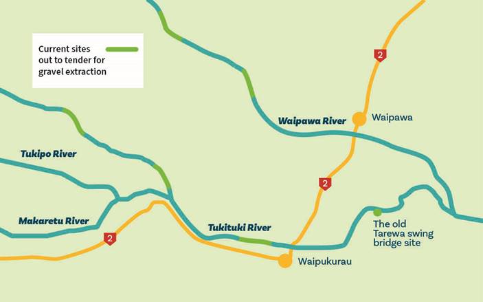
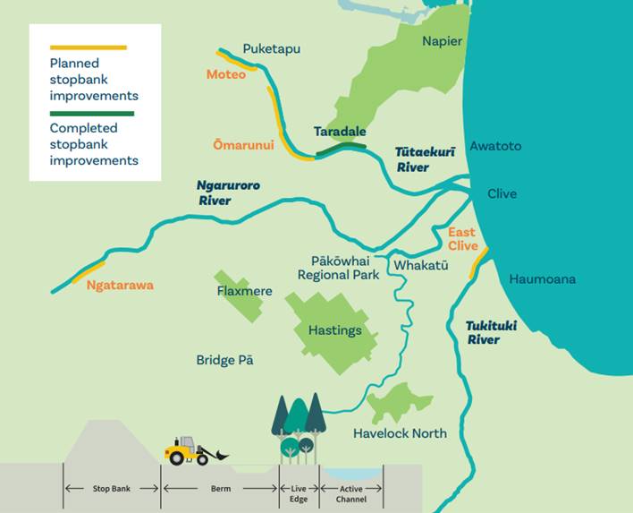
diagrams 1, 2 and 3:
2.1. Heretaunga Plains Flood Control Scheme
Levels of Service
2.2. Upper Tukituki Flood Control Scheme
Gravel Extraction
2.3. Upper Tukituki Flood Control Scheme
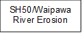
SH50/Waipawa Erosion
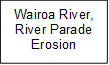
2.4. Wairoa River, River Parade Erosion.


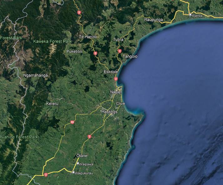
Diagram
1 – Location of the 4 IRG Projects
Diagram
2 – UTT Gravel Extraction -Tranche 2 Focus Areas
Diagram
3 – HPFCS 2022-2023 Stopbank Upgrades
3. Works commenced on all
four projects in late November 2020.
Discussion
Project 1 – Heretaunga Plains Flood
Control Scheme (HPFCS) Levels of Service - $20m
4. The HPFCS Levels of Service project
will review, and upgrade stopbanks across the Tūtaekurī, Ngaruroro,
Lower Tukituki and Clive rivers as part of the Heretaunga Plains Flood Control
Scheme level of service review, to increase flood protection across the scheme
from the current 1 in 100-year flood event to a 1 in 500-year flood event.
5. HBRC are co-funding $7.2 million to
match IRG funds of $12.8 million.
6. Physical works on the Taradale
stopbank are now successfully completed, and the cycleway has been redeveloped
and is now open to the public. Completion of the maintenance access track,
redistribution of topsoil and hydroseeding of the berm areas are due to be
completed by 20 September 2022. Work to be completed in a second tranche
of work includes landscaping and planting, and the development of the Guppy
Road carpark and associated landscaping.
7. Ngatarawa Native Planting –
Tranche one has been completed with a total of 37,000 natives planted over
11ha. Tranche two is currently being planned for the 2023 autumn planting
season. The Ngatarawa stopbank upgrade contract has been tendered with the
physical works contract being awarded on 9 September. Work will commence on
this site in late September/early October and will likely span a duration of 27
weeks.
8. Moteo Stopbank upgrade is nearing the
completion of detailed design and draft contract documents have provided for
review. The design has identified a deficit in borrow material available to
complete the construction works requiring suitable fill material to be
imported. This is likely to require consents from both Hawke’s Bay
Regional Council (HBRC) and Hastings District Council (HDC) to ensure the
quality of imported material is acceptable and will not adversely impact the
environment into which it is placed. Although it was originally intended to
commence tendering of this project in early September, tendering has been
delayed to ensure that the risk of insufficient borrow material is
appropriately managed.
9. In conjunction with progressing consenting
for the Moteo project, consideration will be given to a global consent approach
to ensure that future projects in need of imported fill are catered for from a
consenting perspective.
10. The Omaranui Stopbank design is
currently being progressed to full detailed design, with the intention of
tendering this project prior to Christmas for a January 2023 commencement.
Construction of this stopbank is likely to be separated into two construction
seasons to provide sufficient time to ensure archaeological sites and road
embankments can be appropriately catered for in the design and managed during
construction. Like Moteo, this project is also likely to require imported fill.
11. As a result of the issue of
insufficient borrow material at several project sites – eg Moteo,
Omaranui, the project team are proposing to undertake a Heretaunga Scheme wide
investigation of borrow quantities in order to produce a catalogue of borrow
availability to inform future upgrade works.
12. Initial investigations associated with
the East Clive Stopbank have identified a number of challenges to be addressed
through the planning phase for this project. These include working in closed
proximity to a closed HDC landfill, construction within 100m of wetlands, work
within the coastal zone and uncontrolled/contaminated fill in a section of the
berm. Each of these aspects requires resource consent. Consequently, the
consenting is now the primary pathway for this project and RMA planners have
now been engaged to assign with this process.
13. Planning for the next tranche of
stopbank upgrades (2023-2024 construction season) is underway, with the Raupare
Upper, Chesterhope Upper, Brookfields Lower and Pakowhai Park having been
prioritised for upgrade (see diagram 4 below).


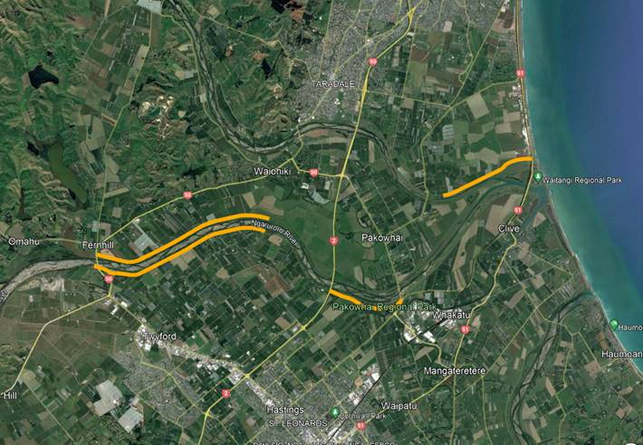
Diagram 4
– HPFCS 2023-2024 Stopbank Upgrades
14. The original programme for this work,
as defined in the Long Term Plan is summarised in Table 1.
|
Year
|
IRG
Contribution
|
HBRC
Contribution
|
Total
|
|
20-21
|
$320,000
|
$180,000
|
$500,000
|
|
21-22
|
$6.24
mill
|
$3.51
mill
|
$9.75
mill
|
|
22-23
|
$6.24
mill
|
$3.51
mill
|
$9.75
mill
|
|
Total
|
$12.8
mill
|
$7.2
mill
|
$20.0
mill
|
Table
1: LTP Budgets for HPFCS LOS Upgrades
15. The Long Term Plan (LTP) budgets were
set prior to the impact of the global Covid-19 pandemic being fully understood,
particularly regarding availability of resources from contractor, consultant,
and internal staffing perspectives. The original programme scheduled 3 stopbank
upgrades to occur in the 2021-2022 financial year, however, due to these
constraints, critical elements experienced delays, resulting in only a single
stopbank progressing to construction in the 2021-2022 financial year.
16. FY 2020-2021 expenditure was $832k.
17. FY 2021-2022 expenditure was $3,846k.
18. With four stopbank upgrades in
progress the anticipated expenditure for this work in the 2022-2023 Financial
Year is $9.33mill.
Project 2 – Upper Tukituki Flood Control Scheme Gravel
Extraction - $8 million
19. The purpose of the Upper Tukituki
(UTT) Gravel Extraction project is to seek opportunities to subsidise
extraction and transportation of gravel from this scheme, with a focus on
competitive tendering and supporting the local economy. Gravel extraction is
required to maintain existing nameplate capacity of 1:100 level of protection
within this scheme. As a consultation topic in the 2020 Long Term Plan, Council
agreed to fund the HBRC co-contribution of $2.88m from the UTT scheme through a
long-term loan allowing the project to proceed.
20. The first tranche of extraction was
completed in July 2022 with two contractors extracting 101,400m3.
Extraction did not reach target volumes due to high river levels limiting
extraction time.
21. The second tranche of extraction
involves three reaches on each of the Waipawa and Upper Tukituki Rivers with a
total of 433,000m3 of gravel being made available. Two of these
reaches have Chilean needle grass present so Regional Projects is working
closely with Biosecurity to ensure the risk associated with extraction these
gravels are adequately managed.
22. Tenders for the second tranche of
extraction are currently under evaluation with 11 submissions received. 5
preferred tenders have been identified. Extraction is likely to proceed in late
September/early October 2022.
23. FY 2020-2021 expenditure was $298k.
24. FY 2021-2022 expenditure was $824k
against an LTP budget of $3m.
25. In FY 2022-2023 costs for the second
tranche of gravel extraction are estimated to be $1.8 million against an LTP
budget of $4.05m.
26. A third tranche of extraction will be
investigated for the 2022-2023 extraction season if the second tranche
progresses in a timely fashion and contractor performance is acceptable.
Project
3 – Upper Tukituki Flood Control Scheme SH50/Waipawa Erosion - $1 million
27. This project is now completed. Photos
1 and 2 illustrate the various rope and rail and akmon/groyne site works.
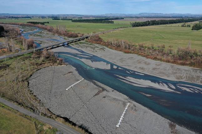
Photo 1
– Akmon and rope and rail features on the true left bank of the Waipawa
River
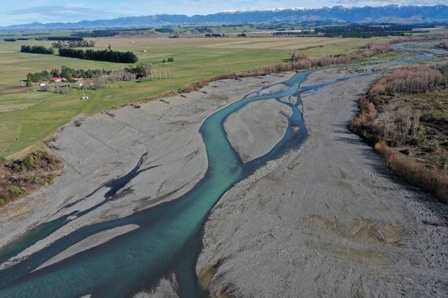
Photo 2
– Rope and Rail features on the true right bank of the Waipawa River
Project 4
– Wairoa River, River Parade Erosion - $1 million
28. This project is substantially
completed, with the fence and path the only work remaining to be completed by
30 September 2022. Photo 3 illustrates the main sheet piling works in progress.
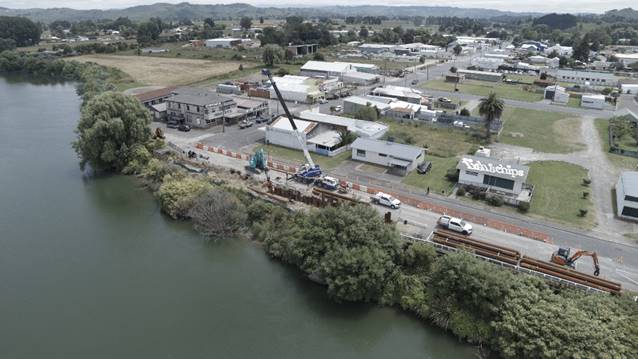
Photo 3
– Sheet Piling works in progress – River Parade, Wairoa River.
Social
Procurement
29. Schedule 3 of the Kanoa funding
agreement details Social Procurement Outcomes (SPOs) which are to be met as
part of the agreement. In order to meet our contractual obligations, HBRC is
implementing the following initiatives.
29.1. Collaboration with Waiohiki Marae to
plan public use of river works for the Tutaekuri river berm reinstatement at
Taradale under the IRG upgrade work.
29.2. Engagement of contractors who employ
staff through Ministry of Social Development’s (MSD) mana in mahi and
Hastings District Council’s redeployment programme
29.3. Networking through MSD to identify
Māori/Pasifika businesses
29.4. Upskilling and training
contractors/consultants through a Tender Training workshop which includes
‘implementation of tender’ training. Three sessions have been
conducted to date.
29.5. Partnering with Eastern Institute of
Technology (EIT) – environmental science, biosecurity, film &
photography. Project study opportunities, project support, work experience,
planting assistance. HBRC has employed two film and two environmental science
students to work and learn as part of the HBRC project team.
29.6. Wellbeing training for consultants and
contractors working in public spaces – linking up service providers with
mental health, well-being, and situational safety programme.
29.7. Highlighting mental health and
wellbeing with our contractors in a drive to include this at toolbox talks
alongside health and safety. Incremental changes to the status quo.
29.8. Establishing partnership agreements to
dedicate project resources to upskill and train staff. This includes
contractors, consultants, and client organisations whereby a continual
professional development style of record keeping is maintained in a simple,
manageable, cost-effective way. This has been successfully implemented in the
Taradale project.
Decision
Making Process
30. Staff have assessed the requirements
of the Local Government Act 2002 in relation to this item and have concluded
that, as this report is for information only, the decision making provisions do
not apply.
Recommendation
That
the Environment and Integrated Catchments Committee receives and notes the steps
staff IRG Programme Delivery to date and next report.
Authored by:
|
Jon Kingsford
Project
Manager
|
|
Approved by:
|
Chris Dolley
Group
Manager Asset Management
|
|
Attachment/s
There are no attachments for this
report.
HAWKE’S
BAY REGIONAL COUNCIL
Environment and Integrated Catchments Committee
Wednesday
21 September 2022
Subject: Napier Meeanee Scheme Review – progress update
Reason
for Report
1. This report and presentation provide
an update of the status and preliminary findings of the Napier Meeanee Drainage
Scheme Review.
2. Staff will provide a presentation of
the work undertaken to date and preliminary findings.
Strategic
Fit
3. During the development of the
2021-2031 Long Term Plan additional resources were made available to review all
flood control and drainage schemes to understand the current level of service,
any gaps to the desired level of service and impact of climate change.
4. The full programme of reviews of all
schemes is to be completed within 10 years.
5. Prioritised schemes were selected on
the basis that urgent review was required to support growth and/or provide a
higher level of service to urban areas.
6. This work supports the Infrastructure
and Services priority area and, specifically by 2030, flood risk is being
managed to adapt to foreseeable climate change risks out to 2100.
7. The scheme reviews will inform the
Asset Management Plan and 30 Year Infrastructure Strategy and allow for
decisions to be made on the appropriate level of capital investment in
subsequent LTP development.
Background
8. Most of the council’s flood
control and drainage schemes have not had a comprehensive scheme review since
they were constructed.
9. For some schemes, particularly those
servicing or adjacent to urban centres, developing or intensification of
agricultural practices, there have been significant land use changes such as
urban development and extensive use of subsurface drainage. These changes to
land use have the potential to impact the level of service provided by a
scheme.
10. In addition, climate change is likely
to impact the level of service of many schemes as annual rainfall decreases by
5-15% by 2040 across the region, we receive more intense storms, and sea level
rises up to 0.4m over the next 40 years (extreme worst-case scenario).
11. The programme of scheme reviews will
review the current level of service, determine the required level of service,
and identify any investment options required to meet or maintain the
appropriate level of service over the 30-year life of the Infrastructure
Strategy.
12. The priority schemes being reviewed,
and their current status are:
12.1. Heretaunga Plains Flood Control Scheme
- upgrade to 1:500-year level of protection; being delivered through IRG
programme
12.2. Napier Meeanee Drainage Scheme - model
developed and current level of service determined; option analysis commenced to
meet level of service requirements
12.3. Karamu catchment servicing Hastings -
project being scoped and early deliverables defined with Hastings District
Council staff
12.4. Wairoa River- will commence when
Napier-Meeanee is completed.
Next
Steps
13. Staff will continue to develop the
Napier Meeanee Drainage Scheme Review and present the final report to a future
Environment and Integrated Catchments Committee (EICC) meeting.
Decision
Making Process
14. Staff have assessed the requirements
of the Local Government Act 2002 in relation to this item and have concluded
that, as this report is for information only, the decision making provisions do
not apply.
Recommendation
That
the Environment and Integrated Catchments Committee receives and notes the Napier
Meeanee Scheme Review – progress update staff report.
Authored and Approved by:
|
Chris Dolley
Group
Manager Asset Management
|
|
Attachment/s
There are no attachments for this
report.
HAWKE’S
BAY REGIONAL COUNCIL
Environment and Integrated Catchments Committee
Wednesday
21 September 2022
Subject: Discussion of Minor Items not on the Agenda
Reason for Report
1. This document
has been prepared to assist Committee Members note the Minor items not on
the agenda to be discussed as determined earlier in agenda item 6.