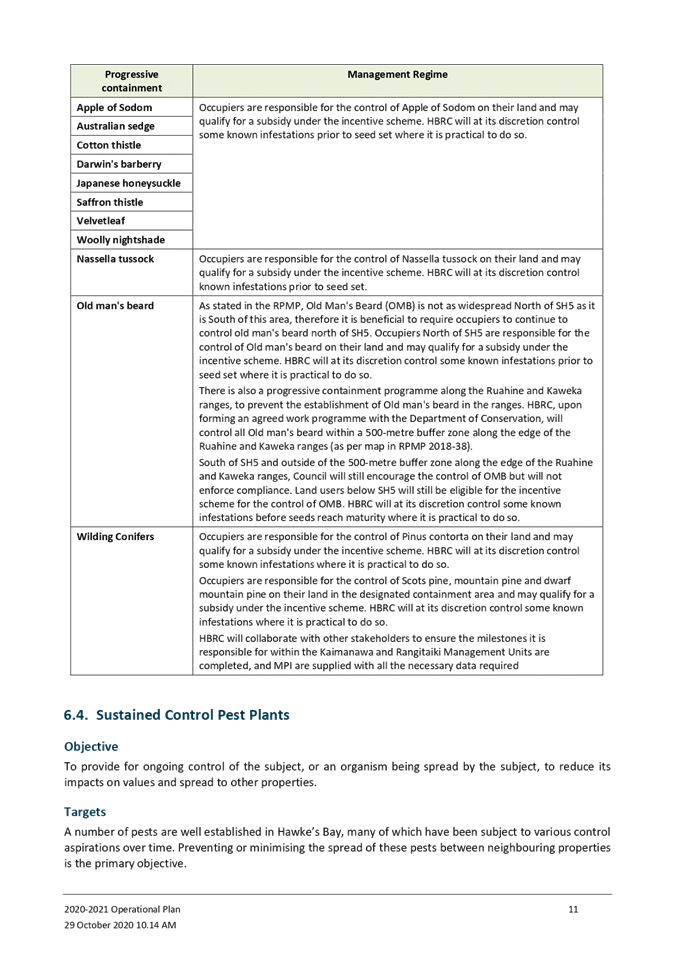
Meeting of the Environment and Integrated Catchments
Committee
Date: Wednesday 4 November 2020
Time: 9.00am
|
Venue:
|
Council Chamber
Hawke's Bay Regional Council
159 Dalton Street
NAPIER
|
Agenda
Item Title Page
1. Welcome/Karakia/Notices/Apologies
2. Conflict
of Interest Declarations
3. Confirmation of
Minutes of the Environment and Integrated Catchments Committee meeting held on
16 September 2020
4. Follow-ups from
Previous Environment and Integrated Catchments Committee Meetings 3
5. Call for Minor
Items Not on the Agenda 7
Information or Performance Monitoring
6. Tūtira
Regional Park and Tangoio Soil Conservation Reserve Forest Harvest Update 9
7. Hawke’s Bay
Marine & Coast Group and Sustainable Seas National Science Challenge
Collaboration 17
8. Marine Biosecurity
Programme Update 21
9. Biosecurity
Operational Plan and Annual Report 25
10. Heretaunga Plains Flood
Control Scheme Review Update 71
11. Crown Funded Flood Resilience
Projects Update 81
12. Presentation - Introduction to
the Landcare Research Wetland Restoration Programme
13. Regional Drought Relief Fund 87
14. Implications of Climate Change
on the Hawke’s Bay Region 91
15. Climate Change Survey Results 95
16. Discussion of Minor Matters
Not on the Agenda 121
HAWKE’S BAY REGIONAL COUNCIL
Environment
and Integrated Catchments Committee
Wednesday 04 November 2020
SUBJECT: Follow-ups from Previous Environment
and Integrated Catchments Committee Meetings
Reason for Report
1. Attachment 1 lists items
raised at previous meetings that require follow-ups. All items indicate who is
responsible for each, when it is expected to be completed and a brief status
comment. Once the items have been completed and reported to the Committee they
will be removed from the list.
Decision Making Process
2. Staff have assessed the requirements of the Local Government Act
2002 in relation to this item and have concluded that, as this report is for
information only, the decision making provisions do not apply.
|
Recommendation
That the Environment and Services Committee
receives and notes the Follow-up Items from Previous Environment &
Services Committee Meetings staff report.
|
Authored by:
|
Annelie Roets
Governance Administration Assistant
|
|
Approved by:
|
James Palmer
Chief Executive
|
|
Attachment/s
|
⇩1
|
Follow-ups
from Previous EICC Meetings
|
|
|
|
Follow-ups
from Previous EICC Meetings
|
Attachment 1
|
Follow-ups from Previous Environment
& Integrated Catchments Committee Meetings
16 September 2020
|
|
Agenda item
|
Follow-up item
|
Responsible
|
Status/Comment
|
|
1.
|
Regional
Water Security - Community Engagement Options via the Regional Water
Assessment
|
Procedural motion
referred decision to 30 September
2020 Regional Council meeting to allow adequate time to consider the options
to better inform decision making, however an alternative engagement model was
put forward as a topic for discussion at the Water Security workshop
scheduled following the Council meeting so there were no recommendations the
30 September Regional Council meeting to consider in this regard.
|
T Skerman
|
Staff
proposed an alternative engagement model at a Water Security workshop on 30
September, to have broader
conversation with all stakeholders through the regional water assessment
process, then bring together the Regional Water Assessment’s interim
findings to Council so that an appropriate community engagement plan can be
developed and finalised for Council’s consideration.
|
HAWKE’S BAY REGIONAL COUNCIL
Environment
and Integrated Catchments Committee
Wednesday 04 November 2020
Subject: Call for Minor Items
Not on the Agenda
Reason
for Report
1. This item provides the means for committee members to raise minor
matters they wish to bring to the attention of the meeting.
2. Hawke’s Bay Regional Council standing order 9.13
states:
2.1. “A
meeting may discuss an item that is not on the agenda only if it is a minor
matter relating to the general business of the meeting and the Chairperson
explains at the beginning of the public part of the meeting that the item will
be discussed. However, the meeting may not make a resolution, decision or
recommendation about the item, except to refer it to a subsequent meeting for
further discussion.”
Recommendations
3. That the Environment and Integrated Catchments Committee accepts the
following “Minor Items
Not on the Agenda” for discussion as Item 16.
|
Leeanne Hooper
GOVERNANCE LEAD
|
James Palmer
CHIEF EXECUTIVE
|
HAWKE’S BAY REGIONAL COUNCIL
Environment
and Integrated Catchments Committee
Wednesday 04 November 2020
Subject: Tūtira Regional
Park and Tangoio Soil Conservation Reserve Forest Harvest Update
Reason for Report
1. This item provides an update on forest harvest in the Tangoio Soil
Conservation Reserve and Tūtira Regional Park.
Executive Summary
2. Environment and
Services Committee 19 June 2019 authorised the appointment of Pan Pac Forest
Products ltd to manage the harvest and sales of forest in the Tangoio Soil
Conservation Reserve (TSCR) and Tūtira Regional Park.
3. Harvest in the
Tangoio Soil Conservation Reserve will have begun by the time this paper is
presented to the Committee. In January, trees will be
removed from roadlines and processing sites in the Tūtira Regional Park
Pine Forest and the roads and skids will then be constructed for harvesting
proper over the 2021-2022 summer.
4. Log prices are
currently within price thresholds recommended by independent advice as
acceptable, however, direct and indirect costs of traffic control in the
Tangoio units will impact significantly on net returns.
5. Following harvest approximately 45 hectares of the TSCR forest will
be retired permanently to native due to the high risks and costs of
harvesting. Following a lengthy consultation process with tangata whenua
(Maungaharuru Tangitū Trust) and the Tūtira community, a recommended
replanting plan for the Tūtira Regional Park Forest will be submitted to
Council for decision in the 3 February EICC Meeting.
Strategic Fit
6. This paper is relevant to HBRC’s strategic goals in various
ways. There is a strong sustainable infrastructure component through HBRC
carrying out its statutory requirement to manage the Tangoio Soil Conservation
Reserve for the purpose of protecting State Highway Two. Harvest and
replanting of the Tūtira Forest in particular provides an opportunity for
HBRC to demonstrate smart, sustainable land use, and has significant
biodiversity and water quality implications.
Discussion
Tangoio Soil Conservation Reserve
7. The Tangoio
Soil Conservation Reserve is Crown land managed by HBRC under the provisions of
the Soil Conservation and Rivers Control Act (1941). Approximately 59% of
the Reserve is in second rotation commercial forest and the remainder in native
vegetation. Proceeds from commercial forestry in the Reserve are held in
the Reserve Fund. The Reserve Fund entirely and without contribution from
rates funds the ongoing management costs of the Reserve and annual payments to
a ‘Catchments Fund’ created by the Maungaharuru Tangitū
Hapū Claims Settlement Act (2014) for the purpose of soil conservation projects
led in partnership between HBRC and Maungaharuru Tangitū
Trust in the Esk, Te Ngārue, Aropaoanui and Waipātiki Catchments.
8. 90ha of pine
forest in the Reserve will be harvested over the period 2020 –
2027. A crew is scheduled to begin in the first 20 hectare unit 2
November 2020 and finish around May. The Tangoio Walkway traverses the land and
has been closed for the duration of the harvest.
9. All units
harvested in this contract border State Highway Two and the risks to traffic
will need to be managed carefully. Traffic control costs will have a
significant impact on net returns, both through direct cost (estimated at
$35,000 in the first unit alone) and through slowing production thereby
increasing the logging rate (Table 1 below).
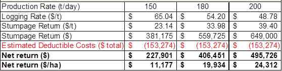
Table 1: Sensitivity to Logging Rates (September Log
Prices)
10. Following harvest,
approximately 45 hectares of the highest risk land will be reverted to
permanent native retirement and the remaining area will be replanted in radiata
pine.
11. Radiata pine has been
selected as the commercial species for several reasons.
11.1. To ensure the ongoing
ability of the Reserve Fund to pay the ongoing Reserve management costs and
Catchments Fund payments, it is important to maintain the productivity of the
48% that will then remain in commercial use after this harvest. No other
commercial species currently consistently achieves the level of financial
returns of radiata pine
11.2. Because markets exist
for even small grades of radiata pine (export grades down to 10cm small end
diameter (SED), more wood can be removed from the slopes above the Highway than
other commercial species
11.3. Pruned stands of radiata
pine provide good conditions for native understorey species and will allow the
native seedbank to develop further for more retirement to native following
future harvests.
Tūtira Regional Park
12. The land that is now
Tūtira Regional Park was purchased by Hawke’s Bay Regional Council
in 1998 and gazetted as a soil conservation reserve under the 1941 Act for the
principle objective of soil conservation to maintain and improve the water
quality in Lake Tūtira and Waikopiro. The secondary objective of
purchase was to provide a quality outdoor recreation environment for the people
of Hawke’s Bay.
13. 114ha of pine forest were
established on the Park between 1991 and 1998 to provide rapid and effective
erosion control, and eventually a financial return on investment.
14. In 2016 as the forest
neared harvest age, feedback from Maungaharuru Tangitū Trust confirmed
removing logs (approximately 2,000 truck and trailer loads) via the existing
Park access would be culturally unacceptable as it would involve traversing an
important waahi tapu site. Environment and Services Committee 15 March
2017 authorised the construction of access roading to the forest via easement
over neighbouring land. This access is now complete, pending the
construction of a bridge over the Kahikanui Stream to be completed this summer.
15. A further access road is
required to harvest the trees from the north of the forest. The road has
to pass over neighbouring land at some points in order to achieve a road grade
suitable for log trucks. A Memorandum of Agreement is being negotiated
with the neighbouring landowner which will see his affected land acquired by
HBRC at no cost in exchange for an easement for the use of the road to remove
his trees in the future and for general access when reasonably required.
16. Significant interest from
tangata whenua (Maungaharuru Tangitū Trust) and the Tūtira Community
in the replanting plan for the Tūtira pine forest led to the establishment
of a working group responsible for submitting a replanting recommendation to
Council for approval. The Working Group has recently agreed the
replanting recommendation and this will be submitted to the 3 February EICC
Meeting.
Stems Harvesting
17. A key factor in awarding
the contract for harvest and sales management to Pan Pac was their ability to
remove whole stems from the forests for processing at their Whirinaki Mill,
thereby requiring less earthworks and leaving less processing waste (slash) on
site. This was a critical factor in particular above the
‘Devil’s Elbow’ where there is very little flat area
available.
18. Pan Pac usually only
processes stems from their own forests at their mill and no effort is made to
record the volumes of different log grades from different forests. It is
not possible therefore to track the volumes of different log grades cut from
HBRC stems in the mill. A process has therefore been established whereby
the log grade mix within each harvest unit is estimated using sample inventory
measurements and industry yield prediction software and combined with current
prices for each grade to form a composite price per tonne of logs. This
composite price is then applied per tonne of logs trucked over the Pan Pac
weighbridge.
Log prices
19. Staff have accepted
independent advice on a range of log thresholds within which prices are
acceptable for harvesting and are using 5% either side of the 5 year averages
for the main grades as a guide.
20. After the significant
initial impacts of Covid-19, log prices have climbed back and are currently
within the agreed range. Domestic prices are fixed for three months
whereas export prices only for one and are therefore subject to greater
volatility. The ongoing impacts of Covid-19 and pressures existing prior
make it impossible to predict future trends.
|
|
5 year average
|
-5%
|
+5%
|
Current price
|
|
Pruned 35
|
$185
|
$176
|
$194
|
$184
|
|
Domestic A
|
$121
|
$115
|
$127
|
$120
|
|
Export A
|
$131
|
$124
|
$138
|
$125
|
Table
2: HBRC Price Thresholds for Logging
21. The
harvest contract allows HBRC to delay harvest if prices fall outside what are
deemed to be favourable, however this will need to be carefully assessed.
Delaying harvest at Tūtira would reduce the time a logged area had to
reestablish in trees and therefore erosion protection prior to the adjoining
area being harvested. Trees above the Highway at Tangoio cannot be
allowed to get too big and heavy due to the greater risk of them
toppling. They are not close to that point yet.
Next
Steps
22. Staff
will present the Committee with a further update and a recommendation for the
Tūtira Regional Park Pine Forest replanting in EICC Meeting 3 February
2021.
Decision Making Process
23. Staff have assessed the
requirements of the Local Government Act 2002 in relation to this item and have
concluded that, as this report is for information only, the decision making
provisions do not apply.
|
Recommendation
That the Environment and Integrated
Catchments Committee receives and notes the “Tūtira Regional Park and Tangoio Soil Conservation Reserve
Forest Harvest Update” staff report.
|
Authored by: Approved
by:
|
Ben Douglas
Forest Management Advisor
|
Chris
Dolley
Group
Manager Asset Management
|
Attachment/s
|
⇩1
|
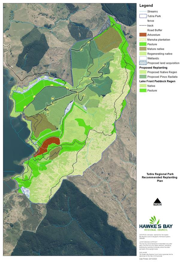
Tūtira
Regional Park and Tangoio Soil Conservation Reserve Location Map
|
|
|
|
⇩2
|
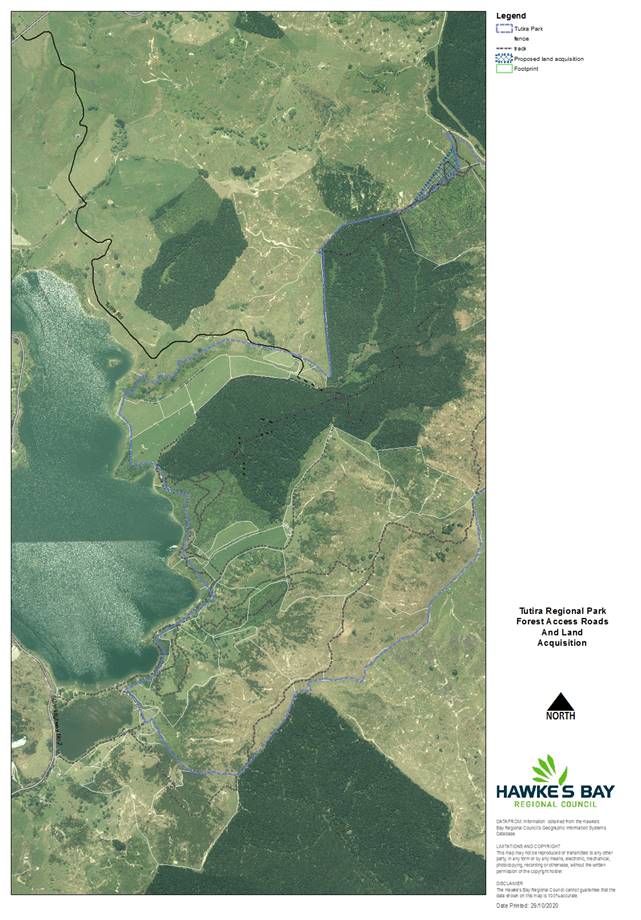
Tūtira
Roads and Land Acquisition
|
|
|
|
Tūtira
Regional Park and Tangoio Soil Conservation Reserve Location Map
|
Attachment 1
|
Tūtira Regional Park Long-Term Vegetation
Plan
|
Tutira Roads and Land
Acquisition
|
Attachment 2
|
Tutira Roads and Land
Acquisition
HAWKE’S BAY REGIONAL COUNCIL
Environment
and Integrated Catchments Committee
Wednesday 04 November 2020
Subject: Hawke’s Bay
Marine & Coast Group and Sustainable Seas National Science Challenge
Collaboration
Reason for Report
1. This report provides an update on the organisational activities
associated with Hawke’s Bay Regional Council’s collaboration with
the Hawke’s Bay Marine and Coast Group (HBMaC) and the Sustainable Seas
National Science Challenge.
Executive Summary
2. Hawke’s Bay Marine and Coast Group is a collaborative group
convened to identify research needs and recommend research objectives to fill
knowledge gaps to assist in the ongoing sustainable management of the
Hawke’s Bay Coastal Marine Area.
3. Since 2018, the group has been working with the Sustainable Seas
National Science Challenge in a regional case study aimed at implementing the
principals of Ecosystem Based Management on the ground.
4. In 2019, stage one of the case study was undertaken which looked at
two stressors; land based sediment and changes to the seafloor from bottom
contact, using a socio-ecological tool called a systems map.
5. The project is currently waiting for confirmation of funding for
stage two which will model potential management scenarios, looking at the
impact of these scenarios on the values we hold for the coastal marine area.
Strategic Fit
6. This activity assists Council to meet its strategic goal of
‘Healthy, functioning and climate-resilient biodiversity’,
specifically to:
6.1. Develop a Coastal Marine Monitoring and Management Plan, supported
by the stakeholder-led Coastal Marine research strategy.
7. This project aligns with Marine and Coast science activities
assessing land-based impacts on the coastal marine area.
Background
8. Management of the coastal marine area in Hawke’s Bay is
undertaken by a number of agencies and entities, covering a number of
legislative documents. These include the Resource Management Act 1991,
Biosecurity Act 1993, Conservation Act 1987, Fisheries Act 1996, Māori
Fisheries Act 2004, Maritime Transport Act 1994, Marine and Coastal Area
(Takutai Moana) Act 2011, and the Marine Mammals Protection Act 1978, as well
as a number of other non-statutory documents.
9. In 2016, local concern around the perceived depletion of inshore
fisheries and fish habitat in Hawke’s Bay marked a Council initiative to
begin a collaboration between Hawke’s Bay Regional Council and others
with interests in the Hawke’s Bay coastal marine area.
10. The
Hawke’s Bay Marine and Coast Group (HBMaC) is comprised of
representatives from recreational and commercial fishers, LegaSea, Department
of Conservation, Fisheries New Zealand (MPI), local iwi, hapū and representation from two post-treaty settlement
groups. Hawke’s Bay Regional Council science staff are both
participants in, and the facilitators of this group.
11. HBMaC’s
purpose is to provide recommendations on improving the information and evidential
base of decision-making in the management of Hawke’s Bay coastal marine
area. HBMaC developed the Research Roadmap which covers three themes:
11.1. Terrestrial
and Coastal Linkages
11.2. Ecosystems
and Habitats
11.3. Fisheries
12. Due to
the existing relationships held within the HBMaC group, Hawke’s Bay was
approached to participate in the Sustainable Seas National Science Challenge as
a case study area. The National Science Challenges are cross-disciplinary,
mission-led programmes designed to tackle New Zealand’s biggest
science-based challenges.
13. The
Hawke’s Bay case study is focused on enabling (rather than
implementing) Ecosystem Based Management (EBM) in Hawke’s Bay.
Discussion
14. Sustainable
Seas is one of 11 National Science Challenges established in 2014 to direct
science funding towards some of the biggest science-based issues and
opportunities facing New Zealand.
15. In 2018,
Hawke’s Bay Regional Council commenced discussions with the Sustainable
Seas leadership team regarding participating as a case study area. This
would enable Sustainable Seas to trial EBM tools they already had developed,
and enable HBMaC to assess what further information may be required to underpin
Ecosystem Based Management in Hawke’s Bay.
16. The HBMaC
vision of ‘Achieve a healthy and functioning marine ecosystem in
Hawke’s Bay that supports an abundant and sustainable fishery’ is
well aligned to the Sustainable Seas vision ‘Aotearoa New Zealand has
healthy marine ecosystems that provide value for every New Zealander’.
17. EBM is an
approach to management that addresses cumulative impacts and balances multiple,
often conflicting, objectives across management objectives and/ or sectors. A
primary goal of EBM is to balance the diverse and interconnected needs of society
and the environment.
18. Stage one
of the Hawke’s Bay project focused on two main stressors: land-derived
sediments entering the marine environment and bottom contact from fisheries
activities (e.g. trawling). Three full day workshops were held with HBMaC
participants and the Sustainable Seas project team. These workshops
looked at the aspects that influence the two stressors (including social and
ecological aspects), as well as projected patterns under different scenarios
(e.g. do nothing, current or projected management).
19. A systems
map, a way to visually articulate the relationships between variables that best
explain the behaviour of the system that you are trying to understand, was
developed. This highlighted four areas where our desired state differed
from our current state. These included:
19.1. Land-derived
sediment entering the marine environment
19.2. Appropriate
benthic structure (e.g. complex habitat, sand, mud etc)
19.3. Loss of
connection with Tangaroa
19.4. Public
satisfaction with ecosystem health.
20. The final
workshop was held a week before COVID lockdown and so further discussions were
slightly hampered by the time delay between the workshop and reporting, and
also due to travel limitations by some participants in that week.
21. The
report and map have been finalised and are in the publication process.
22. Stage two
of the project will investigate the impact of different management scenarios on
reducing the gaps between the current and desired state using existing tools
developed in the Sustainable Seas programme. We are proposing to trial a
Degradation and Recovery Model to simulate changes in management (e.g. changes
to sediment delivery, changes to bottom contact from trawl gear etc) and
understand what that may mean for seafloor health.
23. These
scenarios will then be returned to the systems map to understand the
implications of these actions in the socio-ecological space.
24. We
envisage that this will highlight areas of multiple and competing values, and
potential conflicts, and have signaled to Sustainable Seas that further work is
likely to be required in this space. This includes support around looking
at risk and uncertainty in decision-making.
25. This is a
Sustainable Seas project, and as such all funding is held by them.
Hawke’s Bay Regional Council are contributing staff time to support this
project.
Next
Steps
26. HBMaC is
currently awaiting decisions from the Sustainable Seas board on funding of
stage 2 of the project; expected November/December 2020.
27. In future
we anticipate that this project will assist Council to deliver the Kotahi Plan.
Decision Making
Process
28. Staff have assessed the
requirements of the Local Government Act 2002 in relation to this item and have
concluded that, as this report is for information only, the decision making
provisions do not apply.
|
Recommendation
That the Environment and Integrated
Catchments Committee receives and notes the “Hawke’s Bay
Marine & Coast Group and Sustainable Seas National Science Challenge
Collaboration” staff report.
|
Authored by:
|
Anna
Madarasz-Smith
Team Leader/Principal Scientist Marine and
Coast
|
Ellen
Robotham
Policy Planner
|
|
Becky
Shanahan
Scientist Marine and Coasts
|
|
Approved by:
|
Iain Maxwell
Group Manager Integrated Catchment
Management
|
|
Attachment/s
There are no
attachments for this report.
HAWKE’S BAY REGIONAL
COUNCIL
Environment
and Integrated Catchments Committee
Wednesday 04 November 2020
Subject: Marine Biosecurity
Programme Update
Reason for Report
1. This report provides an overview and update on the Marine
Biosecurity Programme, currently being delivered by the Catchment Services
team.
Executive Summary
2. Marine pests were included in the 2018-38 Hawke’s Bay Regional Pest Management Plan (RPMP) for the first time.
3. The aim of the Hawke’s Bay marine biosecurity programme is to
reduce the likelihood of marine pests establishing in Hawke’s Bay,
primarily via the movement of vessels with bio-fouling.
4. In the short time the marine biosecurity programme has been
operating, 24 vessels have been inspected and two vessels with marine pests
have been intercepted on their arrival to Hawke’s Bay.
5. No established populations of exclusion marine pests have been
detected to date in Hawke’s Bay waters.
Strategic Fit
6. This marine pest programme sits within a biosecurity framework for
the Hawke’s Bay region, which includes the RPMP, the Hawke’s Bay
Biodiversity Strategy and the HBRC Strategic Plan. This programme also aligns
with the work the Marine and Coast science team carries out protecting and
enhancing our marine environment.
Background
7. Marine pests compete with and prey on native species, modify natural
habitats, affect marine industries, and alter ecosystem processes. Once
here, they are difficult and expensive to get rid of.
8. Marine pests are established in a number of regions throughout New
Zealand including Northland Auckland, Waikato and Bay of Plenty. Hawke’s
Bay is currently in the enviable position of not having any of the worst marine
pests established within the region.
9. The main pathway in which marine pests are spread is through
bio-fouling on vessel hulls.
10. In order
to reduce the risk of marine pests being transported to Hawke’s Bay, a
marine biosecurity programme was included in the Hawke’s Bay RPMP
(2018-2038). Two marine pests are included as Exclusion Pests (Clubbed tunicate
and Mediterranean fanworm) alongside a Clean Hull rule, which states that all
vessels and structures that enter Hawke’s Bay waters must have no more
than a slime layer and/or goose barnacles. A breach of this rule is an
offence under the biosecurity act.
Discussion
11. When a
vessel enters Hawke’s Bay waters and berths in the Inner Harbor an
Incoming Vessel Form containing specific biosecurity questions must be
completed by the skipper and submitted to HBRC. A risk analysis is
undertaken using this information and if the vessel is suspected to be high
risk of not complying with the HBRC Clean Hull rule divers will inspect the
vessel.
12. The table
below shows the number of incoming vessels that have been assessed, and the
levels of compliance.
|
# of
Incoming Vessel Forms received
|
133
|
|
# of vessels
inspected
|
24
|
|
# of vessels inspected compliant with Clean Hull Rule
|
8
|
|
# of vessels inspected not compliant with Clean Hull Rule
|
16
|
|
# of non-compliant vessels directed to be hauled out or leave HB
waters
|
15
|
|
# of marine
pest incursions
|
2
|
13. Council
staff responded to all non-compliant vessels and marine pest incursions by
either directing the vessel to be hauled out and cleaned, or to leave
Hawke’s Bay waters.
14. Additionally,
a biennial marine pest survey is undertaken of the Ahuriri Inner Harbour using
divers. If a marine pest was found in the early stages of establishment
we would have a better chance of eradicating it. No new marine pests have been
found to date.
15. HBRC is a
member of the Top of the North Marine Biosecurity Partnership (Auckland
Council, Northland Regional Council, Gisborne District Council, Waikato
Regional Council, Bay of Plenty Regional Council and Biosecurity New Zealand).
The partnership shares information, best practice, resources and collaborate on
research. In conjunction with Eagle Technology the Partnership is also
developing a Marine Vessel Portal where information
on vessel information and pest distribution can be shared between
organisations.
16. A key
constraint for the HBRC marine biosecurity programme is the lack of national
coordination. Marine biosecurity is a national issue as the risk of marine
pests spreading arises when vessels move between regions. Currently, there are
no national rules regarding vessel cleanliness. This results in a disjointed
approach which is a cause of frustration for Councils and vessel owners.
Biosecurity New Zealand have indicated that they are now looking into
developing a National Marine Biosecurity Strategy.
17. Another
constraint is the Napier Port is not included in the national Marine High Risk
Site Surveillance (MHRSS) programme. The MHRSS is a national programme of surveys targeted at the early
detection of high-risk marine non-indigenous species undertaken in 11 ports and
marinas in New Zealand. This programme is managed by Biosecurity New Zealand. A
baseline survey was last carried out in 2003 by Biosecurity New Zealand,
however, no surveillance for marine pests has been undertaken since this survey
as part of the national programme. Therefore, whilst HBRC carry out biennial
surveys for marine pests at the Ahuriri Inner Harbour the lack of marine pest
surveillance at Napier Port leaves the risk that new to Hawke’s Bay or new
to New Zealand marine pests have established at the port. HBRC staff continue
to advocate to Biosecurity New Zealand to undertake more regular surveys.
Next
Steps
18. The
marine biosecurity programme has been shown to be highly valuable within the
short time it has been running. This is highlighted by the two marine pest
incursions that have been intercepted on vessel hulls and managed following
best practice. One of these vessels had two mature Mediterranean fanworm on the
hull and was coming to Hawke’s Bay to berth permanently. Had this
incursion not been intercepted, it is likely this marine pest would have
established in Hawke’s Bay.
19. The Top
of the North Marine Biosecurity Partnership, has been invaluable in the
development and implementation of HBRC’s marine biosecurity programme.
This collaboration continues to grow of which HBRC as a minor party
significantly benefits from.
20. The Top
of the North Marine Biosecurity Partnership is currently developing an
Inter-regional Marine Pathway Management Plan. This plan would implement a
consistent set of rules for the level of allowable hull-fouling on vessels
within those regions implementing this plan.
Decision Making
Process
21. Staff have assessed the
requirements of the Local Government Act 2002 in relation to this item and have
concluded that, as this report is for information only, the decision making
provisions do not apply.
|
Recommendation
That the Environment and Integrated
Catchments Committee receives and notes the “Marine Biosecurity
Programme Update” staff report.
|
Authored by:
|
Alice McNatty
Team Leader Pest Plants and Marine
Biodiversity
|
Mark Mitchell
Team Leader/Principal Advisor,
Biosecurity/Biodiversity
|
Approved by:
|
Iain Maxwell
Group Manager Integrated Catchment
Management
|
|
Attachment/s
There are no
attachments for this report.
HAWKE’S BAY REGIONAL
COUNCIL
Environment
and Integrated Catchments Committee
Wednesday 04 November 2020
Subject: Biosecurity Operational
Plan and Annual Report
Reason for Report
1. This item presents the Hawke’s Bay Regional Council’s
Biosecurity Annual Report for the 2019-20 year and Operational Plan for the
2020-2021 year.
Executive Summary
2. Pest management is an important part of the sustainable management
of natural resources in Hawke’s Bay. The Hawke’s Bay Regional
Council (Council) manages risks posed by pests and other organisms through its
Biosecurity programme. The Hawke’s Bay Regional Pest Management Plan
(RPMP) 2018-2038 is the core document behind this and establishes the
regulatory basis for pest management in Hawke’s Bay. The RPMP was
made operative in February 2019.
3. As the management agency, Council is required to prepare an annual
operational plan that sets out how the RPMP is to be implemented. Following the
end of each financial year, Council is required to produce an Annual Report,
recording progress in implementation of the RPMP via the Operational Plan.
Strategic Fit
4. Regional pest management sits within a biosecurity framework for the
Hawke’s Bay region, which includes the RPMP, the Hawke’s Bay
Biodiversity Strategy and the HBRC Strategic Plan. Neighbouring Regional Pest
Management Plans and national legislation, policy and initiatives have also
influenced Hawke’s Bays RPMP.
Background
5. Regional councils have a mandate under Part 2 of the Biosecurity Act
1993 (the Act) to provide regional leadership in activities that prevent,
reduce, or eliminate adverse effects from harmful organisms that are present in
their region. Council therefore has this leadership role in the
Hawke’s Bay region.
6. The purpose of the Hawke’s Bay Regional Pest Management Plan
is to provide for the efficient and effective management or eradication of
specified harmful organisms in the Hawke’s Bay Region. It builds on the
2013 Strategy and previous pest management programmes. The purpose of the Plan
is to:
6.1 minimise the actual or potential adverse or unintended effects
associated with those organisms; and
6.2 maximise the effectiveness of individual actions in managing pests
through a regionally coordinated approach.
7. Many organisms in the Hawke’s Bay region are considered
undesirable or a nuisance. The Regional Pest Management Plan only addresses
pests where voluntary action is insufficient due to the nature of the pest or
the related costs and benefits of individual action or inaction. The Act
specifies criteria that must be met to justify such intervention.
8. The RPMP empowers Council to exercise the relevant advisory, service
delivery, regulatory and funding provisions available under the Act to deliver
the specific objectives identified within the Plan.
Discussion
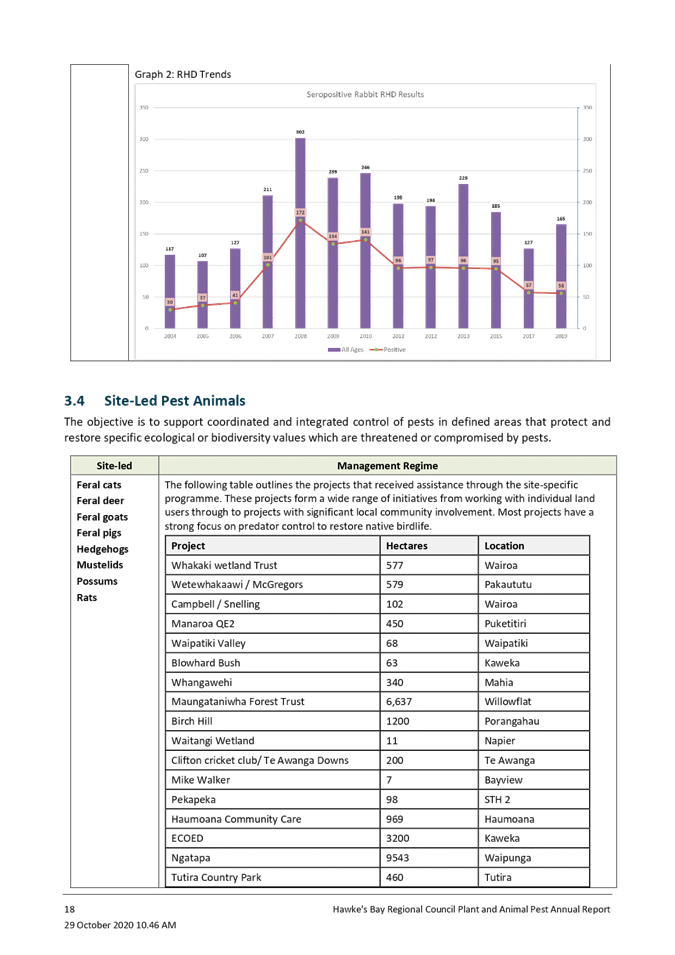
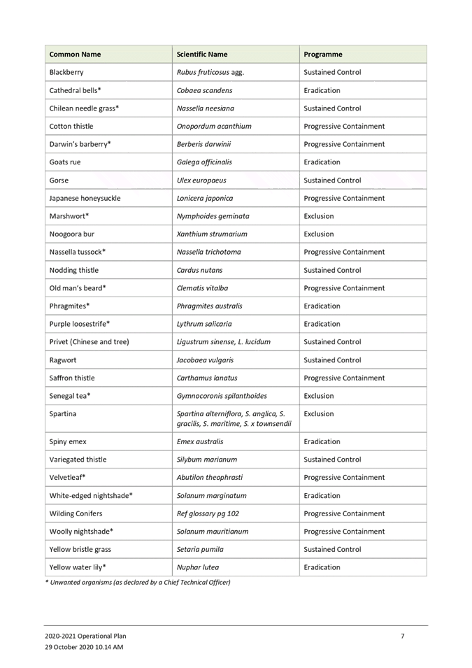
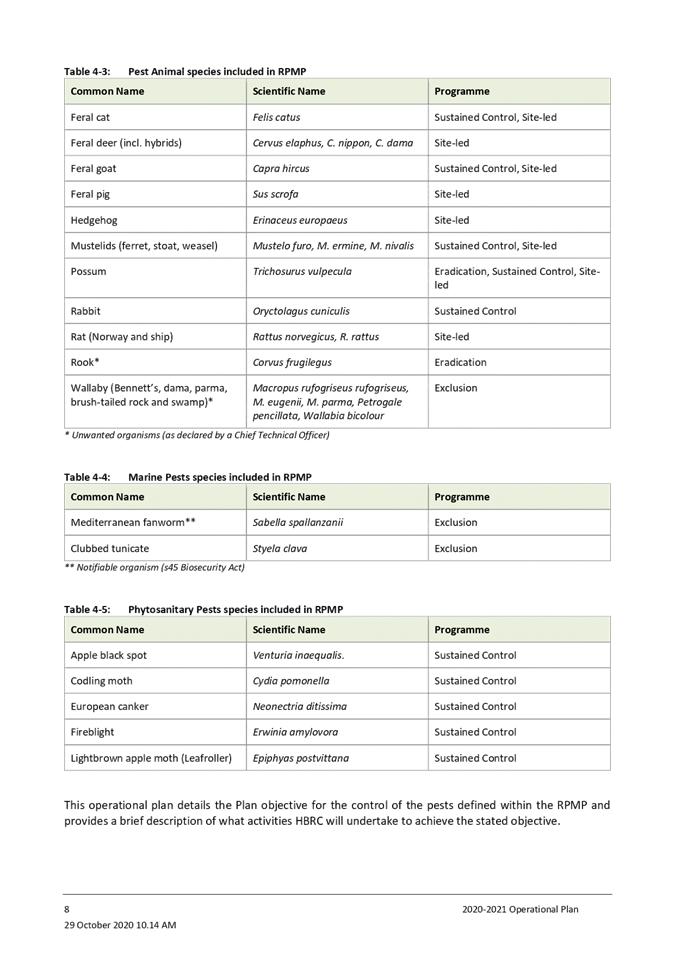
9. The RPMP contains 63 pests, comprising of 33 pest plants, 23 pest
animals, two marine pests and five horticultural pests.
10. Some of
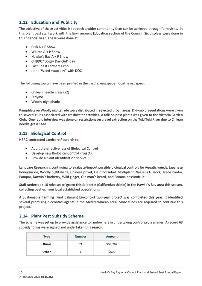
the key outputs during the 2019-2020 financial year were:
10.1. The
Pest Plant team visited 2,334 properties undertaking weed control or auditing
10.2. Staff
undertook 10 biocontrol releases (Californian green thistle beetle)
10.3. No
exclusion pest plants were detected in the Hawke’s Bay region
10.4. A
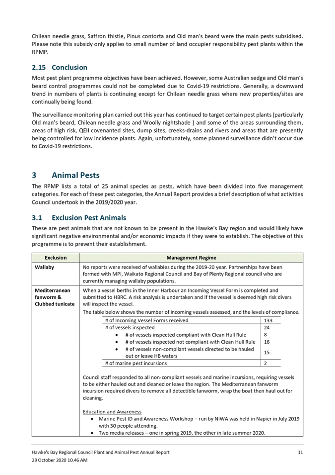
biosecurity response was undertaken for Mediterranean fanworm, an exclusion
pest, which was detected on the hull of a vessel in the inner Ahuriri harbour
10.5. Fifteen
Notices of Direction were issued
10.6. A total
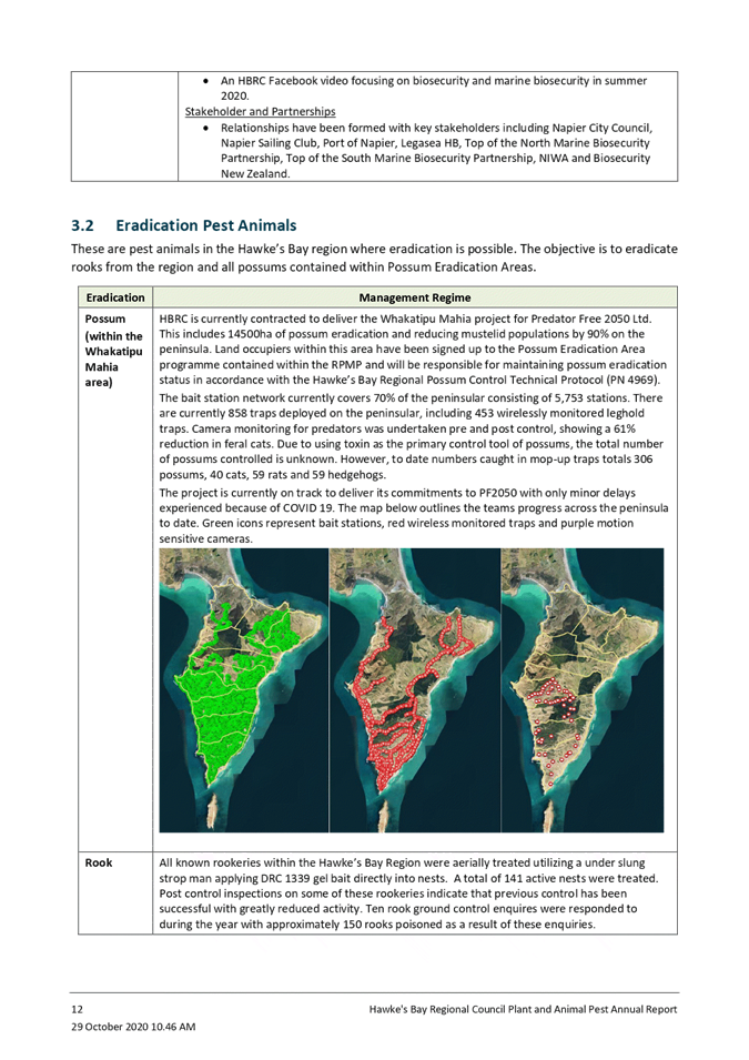
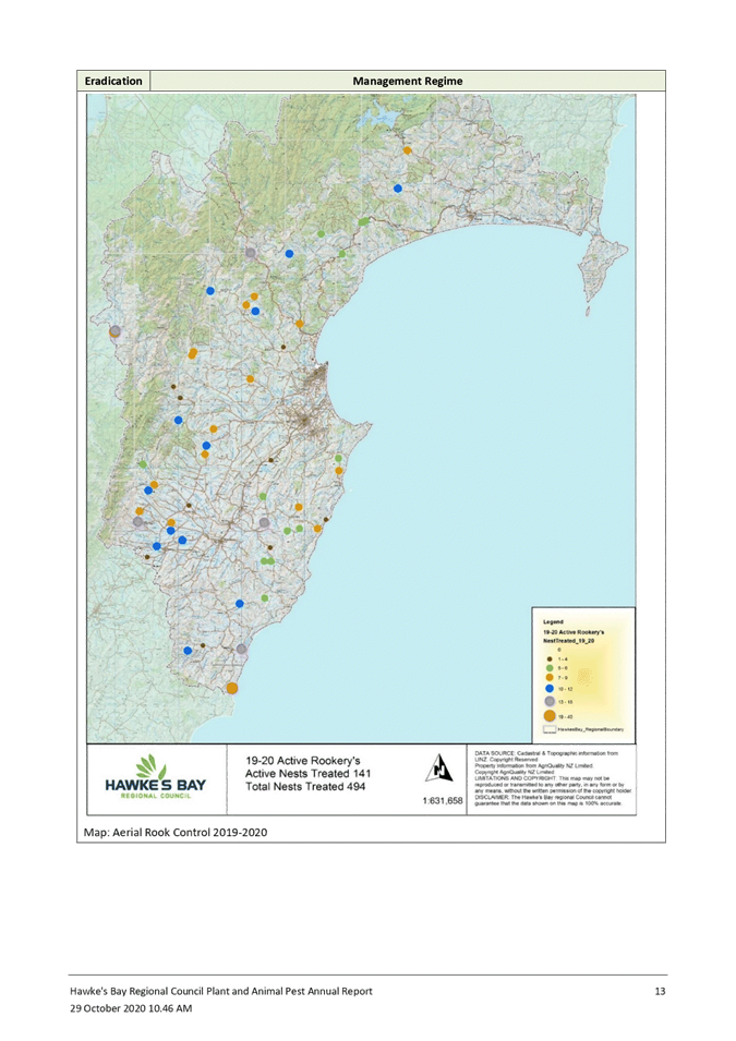
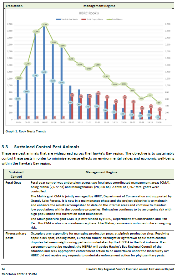
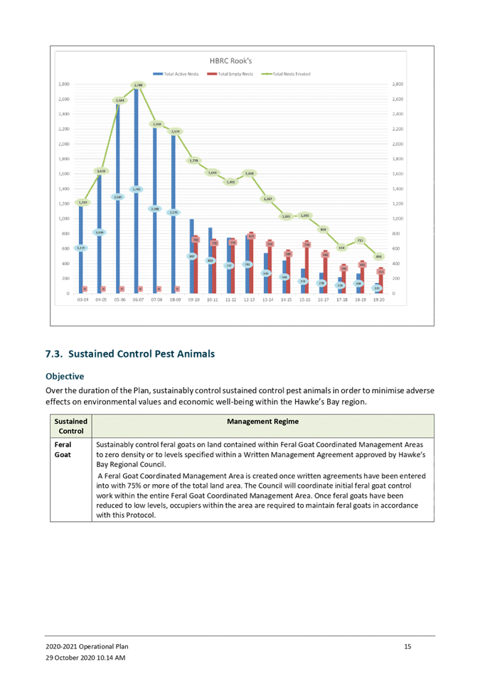
of 141 active rook nests were treated
10.7. A total
of 1,267 feral goats were controlled within the Mahia and Maungaharuru feral
goat coordinated management areas (CMA)
10.8. A total
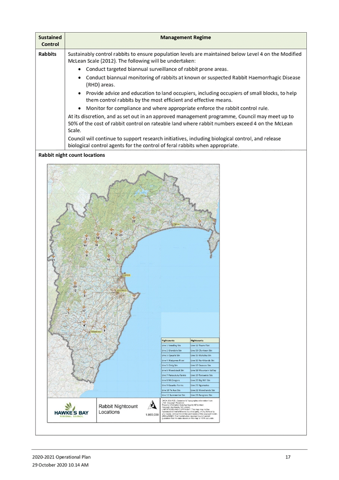
of 66 rabbit enquiries were responded to
10.9. Staff
worked with 32 land occupies/community groups in managing site specific pests,
primarily predators
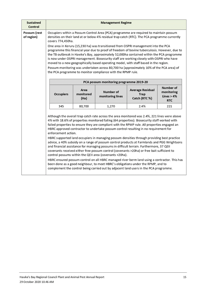
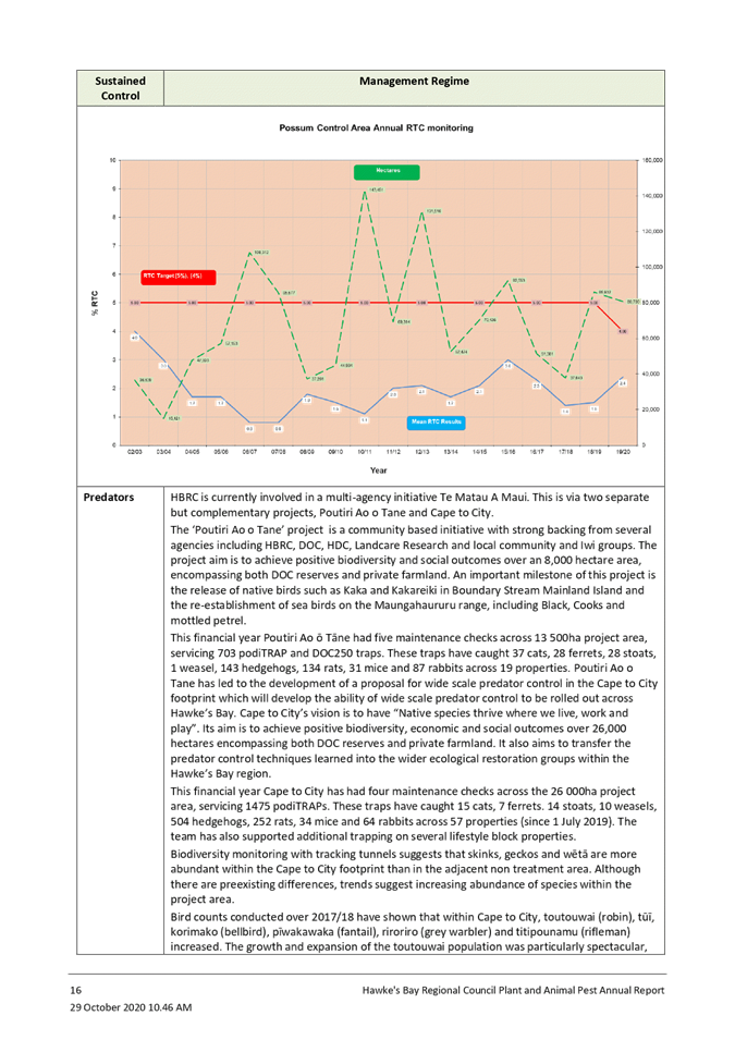
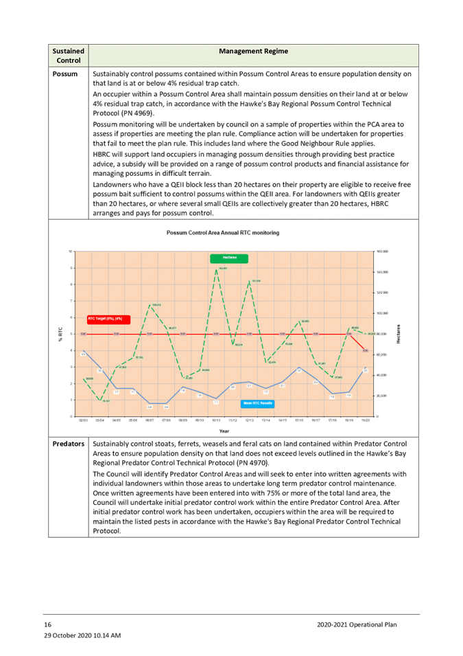
10.10. Possum monitoring was
undertaken across 80,700 ha (approximately 10% of the PCA area) with the
overall trap catch rate across the area being 2.4%
10.11. Predators were
controlled over 54,000 ha, removing 92 feral cats, 37 ferrets, 42 stoats, 706
hedgehogs and 945 rats
10.12. Outcome monitoring
showed increases in native bird abundance within the predator control areas
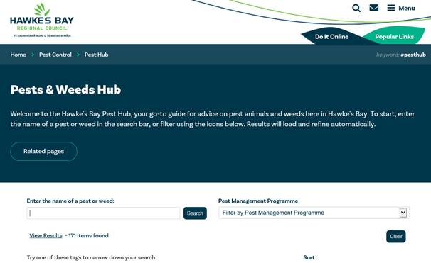
10.13. New Council Pest Hub
website was implemented.
11. Almost
all programme objectives were achieved. However, some Australian sedge and Old
man’s beard control could not be completed due to Covid-19 restrictions.
12. Although
almost all programme objectives were achieved, the following areas of concern
were identified:
12.1. 221
possum monitoring lines were above a 4% RTC, resulting in 64 properties failing
their monitor (18.6% of properties monitored)
12.2. Rabbit
enquiries continue to increase, particularly in urban areas. Rabbits are a
difficult pest to control, requiring expensive ongoing management
12.3. The
number of properties with pest plants (primarily Chilean Needle Grass)
continues to grow, resulting in increased pressure on Pest Plant budgets and
staff.
Next
Steps
13. A review
under S17a of the Local Government Act (LGA) 2002, was recently undertaken to assess the efficiency and effectiveness
of the Catchment Services biosecurity and biodiversity programmes. The review
was reported to Council in September 2020. This report highlighted
several areas that require further investigation, including resourcing for pest
plants, approaches for managing rabbits and the delivery model for managing
possums. The Catchment Services team is currently working through these
recommendations, with further advice coming back to council in the coming
months on proposed changes.
14. Identified
as a significant action arising from the S17a review, the possum control area
programme is undergoing immediate review by an external contractor. The
findings of this review and advice on any required changes and resourcing
implications will be presented to council early next year for inclusion in the
2021-22 Annual Plan and associated consultative processes. In the interim, the
Pest Animal team has directed more resources this current financial year into
possum monitoring across the PCA.
15. As
another placeholder, further resources for possum monitoring and pest plant
management have been requested within the 2021-31 LTP process. This will
address some of the immediate areas of concern and more substantive and
enduring proposals will come back to council for advice and required changes
for inclusion in Annual Plans. This slight delay will allow staff to
complete comprehensive reviews and ensure that the proposed changes are well
thought through, can be effectively implemented and can go through appropriate
consultative processes.
16. Staff
have ramped up the communication with OSPRI, who have moved to a new
geographically based operating model, with staff now based in the region. There
are currently 19 herds infected and five herds under investigation in the
current TB outbreak area. OSPRI believe they are managing the outbreak and
expect the number of infected herds to drop substantially over the next 6
months.
Decision Making
Process
17. Staff have assessed the
requirements of the Local Government Act 2002 in relation to this item and have
concluded that, as this report is for information only, the decision making
provisions do not apply.
|
Recommendation
That the Environment and Integrated
Catchments Committee receives and notes the “Biosecurity Operational
Plan and Annual Report” staff reports.
|
Authored by:
|
Mark Mitchell
Team Leader/Principal Advisor,
Biosecurity/Biodiversity
|
|
Approved by:
|
Iain Maxwell
Group Manager Integrated Catchment
Management
|
|
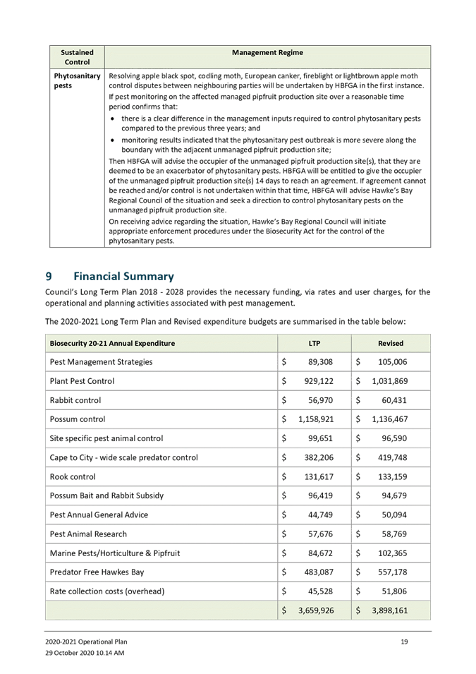
Attachment/s
|
⇩1
|
HBRC Biosecurity
2019-20 Annual Report
|
|
|
|
⇩2
|
Combined Pest
Plant and Pest Animal Operational Plan 2020-2021
|
|
|
|
HBRC
Biosecurity 2019-20 Annual Report
|
Attachment 1
|


|
Combined
Pest Plant and Pest Animal Operational Plan 2020-2021
|
Attachment 2
|

HAWKE’S BAY REGIONAL COUNCIL
Environment
and Integrated Catchments Committee
Wednesday 04 November 2020
Subject: Heretaunga Plains Flood
Control Scheme Review Update
Reason for the report
1. This item provides the Committee with an update on the Level of
Service (LoS) review of Heretaunga Plains Flood Control Scheme (HPFCS) rivers,
including progress and future milestones.
Executive Summary
2. Staff will present the key activities and achievements of the
project to date.
3. The project was last presented to Council in July 2020, since then
we have updated the work program to respond to the additional funding from
Government’s Flood Control Resilience Funding.
4. A comprehensive land investigation has been undertaken by The
Property Group to confirm and set the extent of the study area for land located
on both banks of the HPFCS rivers. A 100m corridor on both banks of each
of the rivers to evaluate property risks in regard to land tenure and land
use. An overall risk profile for each land parcel has been developed for
each river, data is hosted on a GIS site. This work will facilitate land
borrow site identification, access requirements, easement instruments and
potential land purchase.
5. As part of the LOS program of work, we reviewed the flood frequency
analysis for the Tutaekuri Rivers in 2020, with 30 years additional hydrologic
data from the previous analysis (1989). The current (2020) analysis shows
that the 100 year flow estimate in 1989 is equivalent to today’s 500 year
flow estimate. This has been independently reviewed by NIWA.
6. The result of the analysis for the Tutaekuri River is that the
current stopbank heights provide adequate protection from overtopping in a 0.2%
AEP (1:500yr) event. Other failure modes need to be examined to determine
the risk of failure during the 0.2% AEP event. These items are discussed
further below.
7. Modelling of the Ngaruroro River will be completed in December 2020
with a focus to identify and prioritise physical works in FY2021-22 and
FY2022-23. The Lower Tukituki River and Clive River modelling is
scheduled to be completed by July 2021.
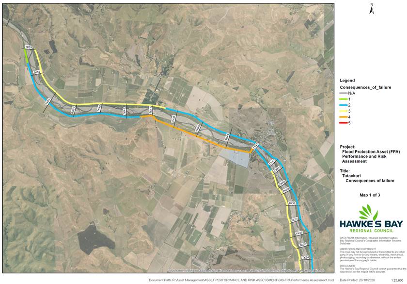
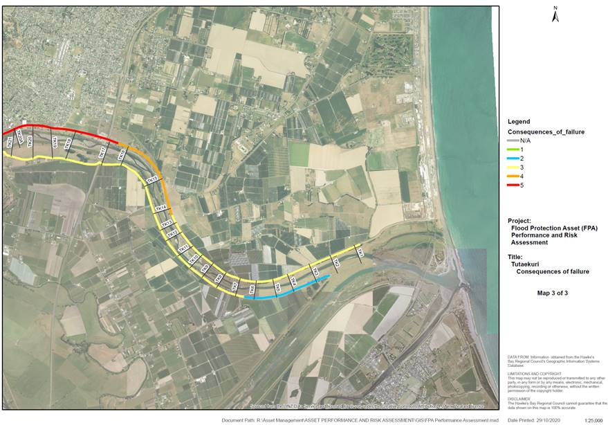
8. A consequences of failure mapping exercise was undertaken for all
rivers. Two sites on the Tutaekuri River (Moteo and Taradale) were
selected for geophysical and geotechnical investigations in preparation for
scoping and strengthening works of the existing stop bank assets. Engineering
design options will be developed following geotechnical assessments and
physical works will be programmed for start in October 2021. Maps are
attached.
9. A priority has been placed to identify sites for improvement works
on the Tutaekuri river to meet Crown funded physical works programme for
FY20-21 due to the completion of modelling and condition assessments on this
river. Refer to attachment 2.
Strategic Fit
10. This
project aligns with council strategy and priority under:
10.1. Climate
change and resilience
10.2. Sustainable
services and infrastructure.
Background
11. Through
the 2012-2022 LTP, it was identified that investment would occur from 2015-2016
onwards “to upgrade stop banks and river edge protection necessary to
provide the required level of service (following the Level of Service review).
12. Through
the 2015 LTP process, HBRC noted that Level of Services will be reviewed over
time but no further specific consultation was carried out.
13. In
2018-2028 LTP consultation document “Facing our Future,” we
informed and listed some major projects and consolation process for next
30years. The project Heretaunga Plains Scheme named in this document states
“Improve flood carrying capacity from a 1 in 100 year event level to
a 1 in 500 year level, in response to climate change.“
14. No
further consultation with public has been carried out since the Facing the
Future document (2018-28 Consultation document) was released.
15. A budget
of $20M (not including Crown funding) was allocated in the 2018 LTP for the
next 10 years.
Discussion
16. Modelling
for Tutaekuri River has indicated confirmation that existing stop bank heights
currently provide protection for the risk of overtopping during a 1 in 500 year
(0.2% AEP) flood event.
17. Non-destructive
geophysical testing and destructive geotechnical testing allows us to
categorise residual risks and likelihood of other failure modes due to
increased velocities and shear stresses. Engineering options shall be
developed to mitigate failure modes by means of strengthening, augmenting or
replacing assets.
18. The
effects of climate change as a relative increase to hydrologic modelling data
is not well defined. The range for each of the representative
concentration pathway (RCPs) scenarios presents considerable uncertainty.
The subsequent increase in flow rate for hydrologic modeling of the HPFCS
rivers has been estimated between 5%-39%.
19. Over the
next 5 years NIWA is scheduled to investigate in detail the impact of climate
change on flood response in NZ to reduce this level of uncertainty.
20. Furthermore,
due to significant variations in the scale, the decision on the appropriate
climate change scenario to adopt is dependent on council’s appetite for
risk (to be discussed during presentation).
Next Steps
21. Engineering
design options shall be developed for Moteo and Taradale sites following
geophysical and geotechnical assessments to align with Crown funding physical
works programme for FY2020-21.
22. HBRC will
engage a third-party consultant (river engineer) to assist in detailed options
analysis for the HPFCS. This will provide an independent overview of our
schemes and offer any opportunities to investigate other options not yet
considered.
23. Each
individual engineering design work package generated for this project will be
distributed to prequalified consultants who meet the requirements of a Panel
Agreement for Engineering Services.
24. A regular
update of the project will be reported to each EICC meeting.
Decision Making
Process
25. Staff have assessed the
requirements of the Local Government Act 2002 in relation to this item and have
concluded that, as this report is for information only, the decision making
provisions do not apply.
|
Recommendation
That the Environment and Integrated
Catchments Committee receives and notes the “Heretaunga
Plains Flood Control Scheme Review Update” staff report.
|
Authored by:
|
Martina
Groves
Regional Asset Manager
|
David
Keracher
Acting Manager
Regional Projects
|
Approved by:
|
Chris Dolley
Group Manager
Asset Management
|
|
Attachment/s
|
⇩1
|
Consequences
of Failure Mapping
|
|
|
|
⇩2
|
Tutaekuri
Sites for Improvements
|
|
|
|
Consequences
of Failure Mapping
|
Attachment 1
|
Consequences
of failure mapping (Tutaekuri river)
|
Tutaekuri Sites for
Improvements
|
Attachment 2
|
Site A: Taradale - XS21b to XS17 (left bank) as shown in pink below
~2.1km
Site B: Moteo - XS47 to XS43a (right bank)
- as shown in green below ~2.7km
HAWKE’S BAY REGIONAL COUNCIL
Environment
and Integrated Catchments Committee
Wednesday 04 November 2020
Subject: Crown Funded Flood
Resilience Projects Update
Reason for Report
1. This report provides an update on four projects approved for funding
as part of the Crown’s Flood Control Resilience Funding with the
Infrastructure Reference Group managed by the Provincial Development Unit
(PDU).
Background
2. In Budget 2020, Cabinet agreed to provide a $3 billion investment in
infrastructure to support New Zealand's economic recovery as part of the 11 May
COVID-19 Response and Recovery Fund.
3. The Government established the Infrastructure Reference Group (IRG)
to identify a pipeline of shovel-ready projects to support the economy during
the COVID-19 rebuild. The process was supported by Crown Infrastructure
Partners.
4. Council have received confirmation from IRG of funding allocation
for a total amount of up to $19.2 m (plus GST, if any) which is a 64%
contribution to the projects.
5. Council received formal approval for allocated funding from
the PDU on 29 September 2020. A signed contract shall be returned to PDU
before 10 November 2020.
6. Several updates to the contract have been issued since the
formal approval including confirmation of queries from other regional councils,
changes to the programme and project brief.
Discussion
Project 1: Heretaunga
Plains Flood Control Scheme (Levels of Service) – $20 m
7. This project is programmed over a three-year period and will build
upon existing river modelling, condition assessment and property analysis
undertaken as part of the Heretaunga Plains Flood Control Scheme (HPFCS) level
of service review.
8. HBRC co-funding of $7.2 million is required to match IRG funds of
$12.8 million.
9. $1.2 m per year has been allocated in the current LTP for FY 2021-22
and 2022-23. This leaves a shortfall of $3.35 million which will be see
$1.675 m brought forward from each of FY 2026-27 and 2027-28.
10. FY
2020-21 includes $500k of allocated funding to undertake stop bank
strengthening at two sites on the Tūtaekurī River, as shown in
figures 1 and 2.
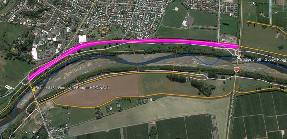
11. Red highlighted area on left bank of Tūtaekurī river
between cross sections XS17-XS22 on Figure 1 below, indicates severe consequence
of failure at the Taradale site, as determined from the
site-specific Flood Protection Asset (FPA) performance and risk assessment
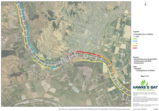
Figure 1 – FPA Performance and Risk Assessment: Taradale site
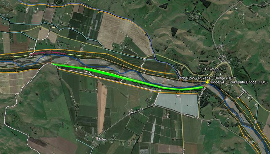
12. Orange
highlighted area on right bank of Tūtaekurī river between cross
sections XS43a-XS47 on Figure 2 below, indicates high consequence of failure at
the Moteo site, as determined from the site specific FPA performance and risk
assessment.
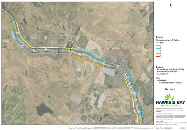
Figure 2 – FPA Performance and Risk
Assessment: Moteo site
13. Modelling
of the Tūtaekurī has confirmed that the existing stop banks can
accommodate overtopping failure for a 1 in 500-year flood event, this however,
excludes increase in water levels due to climate change. In order to
ensure other risks associated with increased velocities and shear stresses are
mitigated, Council are engaging geotechnical specialists to undertake failure
mode analysis using a suite of non-destructive and destructive testing.
Results of geotechnical testing will dictate the scope and type of stop bank
strengthening works required.
14. Each of
the work packages generated for this project will be distributed to
prequalified consultants who meet the requirements of a Panel Agreement for
Engineering Services.
15. Council
will engage a third-party river engineering consultant to undertake a
high-level study of the existing HPFCS. This will provide an independent
overview of our schemes and offer any opportunities to improve level of service
with “out of the box” thinking.
16. Table 1
below provides the budget forecast with breakdown of funding for IRG and
HBRC’s contribution:
Table 1:
Heretaunga Plains Flood Control Scheme Budget Forecast
|
|
IRG Contribution
|
HBRC Contribution
|
|
2020-21
|
$320k
|
$180k
|
|
2021-22
|
$6.24m
|
$3.51m
|
|
2022-23
|
$6.24m
|
$3.51m
|
|
TOTAL
|
$12.8m
|
$7.2m
|
Project 2:
Upper Tukituki Gravel Extraction Flood Control Scheme – $8 million
17. Removal
of over 800,000 m3 gravel is required to maintain existing nameplate
capacity of 1:100 level of protection from Upper Tukituki scheme. Gravel
aggradation across this scheme has been an area of concern for the last decade.
18. IRG
funding is a significant opportunity to subsidise gravel extraction from this
region with a focus on competitive tendering and supporting the local economy.
19. This
project is programmed over a three-year period which requires HBRC co-funding
of $2.88 million to release IRG funding of $5.12 million. It is proposed
that a significant portion of HBRC’s contribution be loan funded then
paid back via targeted and general rates under Upper Tukituki scheme, following
consultation during the 2021-31 LTP.
20. Public
meeting was held on 26 August 2020 to discuss the loan funding options where
there a level of support was expressed by community.
21. Public
meeting with Class A and B ratepayers (high dollar value ratepayers) is
scheduled for November 2020.
22. Scheme
loan will be a consultation topic for 2021-2031 LTP.
23. The
scheme balance of $340k will be used in FY 2020-21 at no cost to Upper Tukituki
scheme ratepayers. This will allow the project to commence without delay.
24. A
workshop was held on 2 September with local gravel extractors to debate options
for extraction from Upper Tukituki Scheme Rivers. The outcomes of this
have been considered and will be explored further in due course.
25. Drone
surveys of Makeretu, Mangaonuku and Tukipo rivers are programmed to commence
this year in order to quantify volumes of aggraded gravels and prioritise key
extraction sites. This will complement existing topographical surveys of
the Upper Tukituki and Waipawa rivers and confirm gravel forecasting over the
next three years.
26. Material
testing of gravels will be undertaken at several locations on each of the
rivers. Crushing, screening and compaction testing will determine suitability
of gravels indicative end use requirements.
27. Strategic
discussions with Central Hawkes Bay District Council (CHBDC) have proved to be
extremely useful in terms of aligning extraction of key sites with Provincial
Growth Funded projects in the region. Whilst this does not currently
leverage on gravel subsidies, it has opened a narrative on responsible use of
river gravels in the region. Council will continue partner with CHBDC to
support future capital projects in order to achieve social and environmental
outcomes whilst contributing to the local economy.
28. Council
have been in discussion with NZTA regarding provision of gravels for the
Manawatu gorge project. Significant volumes may be required based on their
suitability, pending third party testing results.
29. Collaboration
with industry and stakeholders has been identified as a suitable
“vehicle” to deliver key IRG funding outcomes. Emphasis will be
given to social procurement drivers and supporting the local economy.
30. Table 2 below provides the
budget forecast with breakdown of funding for IRG and HBRC’s
contribution:
Table 2 - Upper Tukituki Gravel Extraction
Flood Control Scheme
|
|
IRG Contribution
|
HBRC Contribution
|
|
2020-21
|
$604k
|
$340k
|
|
2021-22
|
$1.92m
|
$1.08m
|
|
2022-23
|
$2.594m
|
$1.46m
|
|
TOTAL
|
$5.12m
|
$2.88m
|
Project 3:
Upper Tukituki Flood Control Scheme SH50/Waipawa Erosion – $1 million
31. This
one-year project programme will provide engineered erosion protection works of
southern approach to NZTA’s SH50 bridge. The left bank of the
Waipawa river immediately upstream of SH50 bridge has eroded significantly over
the past five years. If left unattended, there is a risk that the
southern approach will be compromised and the river may outflank the bridge.
32. Detailed
design for erosion protection works to be completed late October.
33. Methodology
for the project has been agreed with Works Group as part of Early Contractor
Involvement (ECI) and shall form the basis of the contract agreement.
34. Direct
engagement for the works shall be awarded to HBRC Works Group due to the
specialist nature of the project within the riverbed. It is anticipated
that site works will commence in early November.
35. Table 3 below provides the
budget forecast with breakdown of funding for IRG and HBRC’s contribution:
Table 3 -
Upper Tukituki Flood Control Scheme SH50/Waipawa Erosion
|
|
IRG Contribution
|
HBRC Contribution
|
NZTA Contribution
|
|
2020-21
|
$640k
|
$60k
|
$300k
|
|
TOTAL
|
$640k
|
$60k
|
$300k
|
Project 4: River Parade Scour
Protection, Wairoa – $1 million
36. This
one-year project programme will provide steel sheet piled erosion protection
works on left bank of the Wairoa River. Over the last five years the
Wairoa River has gradually undermined the embankment immediately south of the
Ferry Hotel. This has in turn compromised Wairoa District Council (WDC)
water assets and more recently Carroll Street and River Parade.
37. In
September HBRC engineering team held a workshop with Consulting Engineer Gary Williams in order to confirm the alignment of
the proposed steel sheet piled wall, including the curtailment detail upstream.
38. Council
have undertaken ECI with Latteys Group, a specialist sheet piling contractor,
to develop a suite of geotechnical testing for preliminary design
options. The outcome of the preliminary design will allow us to maximise
the lineal meterage of the sheet piled wall, thus providing the greatest
benefit to WDC’s existing compromised assets.
39. The
proposed level of service for the erosion protection shall be confirmed with
WDC as part of the preliminary design. It is expected that design will be
completed early 2021 with site mobilisation anticipated mid-2021, dependent on
steel sheet pile procurement lead times.
40. Table 4 below provides the
budget forecast with breakdown of funding for IRG and HBRC’s
contribution:
Table 4
– River Parade Scour Protection, Wairoa
|
|
IRG Contribution
|
HBRC Contribution
|
WDC Contribution
|
|
2020-21
|
$640k
|
$180k
|
$180k
|
|
TOTAL
|
$640k
|
$180k
|
$180k
|
IRG Contract Requirements
41. The
contractual financial forecasting has been amended to advanced quarterly
payments for each project. This was a result of river managers
SIG’s concerns over balancing over and under throughout the project
lifecycle.
42. Negotiations
continue on specific aspects of the contract with PDU. River Managers SIG
is providing significant input to the standard contract used for all Regional
Councils for this program.
Next Steps
43. The
contract for above noted works shall be signed and returned to the PDU in early
November following completion of programming and budget forecasting.
Decision Making
Process
44. Staff have assessed the
requirements of the Local Government Act 2002 in relation to this item and have
concluded that, as this report is for information only, the decision making
provisions do not apply.
|
Recommendation
That the Environment and Integrated
Catchments Committee receives and notes the “Crown Funded
Flood Resilience Projects Update” staff report.
|
Authored by:
|
David
Keracher
Acting Manager
Regional Projects
|
|
Approved by:
|
Chris Dolley
Group Manager
Asset Management
|
|
Attachment/s
There are no
attachments for this report.
HAWKE’S BAY REGIONAL
COUNCIL
Environment
and Integrated Catchments Committee
Wednesday 04 November 2020
Subject: Regional Drought Relief
Fund
Reason for
Report
1. This item
provides an update on the Regional Drought Relief Fund and discusses
recommended next steps.
Executive
Summary
2. The Regional
Drought Relief Fund (RDRF) which totalled $1,015,110, has distributed $979,561
to assist our rural community with costs related to animal feed transportation
and welfare.
3. Applications to
the fund closed 30 September 2020, leaving $35,549 remaining in the fund.
Background
4. On 12 March
2020, the Ministry for Primary Industries classified the 2019-20 drought as a
large-scale adverse event for the entire North Island.
5. The Hawke's Bay
Rural Advisory Group (RAG) was the lead group for the drought response working
under the Hawke’s Bay Civil Defence and Emergency Management Group
(HBCDEM) structure. The RAG is made up of representatives from rural and
primary sector businesses, agencies and councils.
6. The RAG worked
closely with the Hawke’s Bay Regional Council and the
HBCDEM to co-ordinate activities, information and support for
rural people impacted by the drought and national
lockdown.
Funding
7. On 19 May 2020,
the regions mayors and Regional Council chairman launched the RDRF, in response
to the critical shortage of feed, as a result of the severe and prolonged
drought in Hawke's Bay. The purpose of this fund was to “leave no
one behind” and support the stock feed requirements of as many landowners
as possible through the winter by offering a payment towards the cost of
transporting feed to farm.
8. The fund
initially accrued $1 million including contributions from Ministry
for Primary Industries ($500k), Regional Council ($200k), Central Hawke's Bay
District Council ($50k), Centralines ($50k), Hastings District Council
($200k). The RAG administered the fund held in Trust by the Hawke's Bay
Disaster Relief Trust.
9. In addition to
this government funding, the community raised $15,110 through a GiveaLittle
campaign, promoted by the 'Digging deep for farmers' drive created by the RAG
communications team.
10. The RAG agreed to commit
$10,000 from the RDRF towards the East Coast Rural Support Trust (RST), to
support their work in providing ‘critical care’ personal and
financial support to vulnerable farming families. This small amount of
funding was available for immediate use to supply feed, for veterinary support
or additional on farm labour.
Initial funding criteria
11. The terms of reference for
the RDRF were clear from the outset that the funds raised will support the cost
of transporting feed to the region.
12. The RAG agreed on the
following criteria.
13.1 Funding is for
transportation of feed
13.2 Invoices must be
dated on or after 19 May 2020 (when the RDRF was announced)
13.3 Farm must be in the
Hawke's Bay
13.4 Farm must have
feed/plan budget
13.5 Farm size: Between
20ha-150ha, can claim up to $400
13.6 Farm size: Greater
than 150ha, can claim up to $1,350
13.7 Farms that received
free donated feed (via Rural Support Trust) would have to share their portion
of the transport costs, at the end of spring
13.8 Funding can only be
applied for once.
13. Given the urgency of the
feed requirement, the application process was managed as a high trust model of
targeted assistance in much the way that the government COVID-19 wage subsidy
was applied.
Obtaining funding
14. People were to apply for
funding through the online form on a Regional Council website or drop into any
of our offices to complete an application form. They were to asked to
attach proof of feed transport cost (a recent invoice), along with a bank
deposit slip.
15. For small block owners
(less than 20ha), the RAG and Regional Council organised three separate
'lifestyle feed runs' over three consecutive weekends during May. Feed
was purchased and transported into Hawke’s Bay from all over the country
(Christchurch, Gisborne, Tauranga, Inglewood, New Plymouth and Feilding) and
sold online to small block owners.
16. We sold out of feed within
48 hours for each run, which showed the level of need. On the pickup
days, we relied on volunteers to help load the bales. This included;
Napier Tech Rugby, East Coast Young Farmers, Regional Council staff, Civil
Defence staff, regional councillor Will Foley, and RAG leaders.
17. Furthermore, the RST
organised for donated feed from around the country to be transported into the
region and allocated to those in need. The RDRF paid those transportation
costs.
Funding criteria review July 2020
18. Initially, the RAG
believed demand was going to exceed supply given the scale of the drought and
the estimated number of eligible properties; hence modest limits based on farm
size were agreed. After five weeks, only 103 applications, totalling
$125,550 had been received.
19. In July 2020, the RAG met
to review its fund criteria as uptake was unexpectedly low. The feedback
at that meeting from RAG participants was that the amounts being offered were
too low, many had arranged feed prior to the RDRF being announced (and so
missed out on the support payment) and so the RAG made the following
adjustments.
21.1 Allow those that
organised feed early access to the fund (the eligibility date was shifted to 12
March 20, when the adverse event was declared by MPI)
21.2 Not to on-charge
transportation costs to the recipients of donated feed
21.3 Fund transportation
of stock to properties outside the region to graze, and then back again
21.4 To increase the
limits
21.4.1 Farm size:
Between 20ha-150ha, could claim up to $1,000 (up from $400)
21.4.2 Farm size:
Greater than 150ha, could claim up to $5,000 (up from $1,350)
21.5 To automatically
top up to the new limits those who had already applied by depositing the
difference into their accounts ($224,980)
21.6 To confirm that
applications will close end of September 2020.
20. These criteria changes,
along with new direct marketing initiatives developed to promote the RDRF, via
the RAG communications team, increased uptake in the subsequent weeks.
Funding update, October 20
21. At the close of the fund,
$979,561 was dispersed to support our rural community with costs related to
animal feed transportation and welfare. The fund totalled $1,015,110, which
leaves $35,549 remaining.
22. The lifestyle feed runs
supported 333 farmers who bought 4,902 bales of feed. The total cost of
transportation for the lifestyle feed totalled $14,798.
23. We received 289 online
applications from farmers who claimed a total of $797,650.
|
Northern HB
|
Mid-HB
|
Southern HB
|
|
4
|
173
|
112
|
24. 33 of these applicants
were on farms sized between 20ha-150ha, and 255 were farms sized greater than
150ha.
25. The donated feed
transportation costs totalled $149,613. This covered the cost of
transport only and note the cost of the actual feed. This change resulted
in a greater supply of donated feed being able to come to the region.
26. The A&P showgrounds
was used as the staging area for incoming donated and lifestyle feed over the past
five months. The RDRF contributed approximately $13,000 for costs
associated with this including distribution and collection logistics (labour
and forklift diesel costs), and repairs to the showgrounds access road, which
was damaged by the feed transport trucks.
Building resilience in our rural
communities
27. Hawke's Bay Regional
Council has declared the region is in a climate emergency. This means
increased frequency and intensity of volatile weather events including drought,
and storms.
28. Farmers believe about 65%
of New Zealand’s agriculture will be moderately or severely impacted by
climate change in the next 30 years, according to a survey (MPI, 2019).
29. We want to help farmers
and rural communities prepare for and manage through drought, so they can
pursue a prosperous and sustainable future.
30. In order to do this, we
are facilitating the development of a Regional Drought Resilience Strategy
(RDRS), in partnership with the primary sector, MPI, councils and industry. We
would like to utilize the small amount of remaining funding in the RDRF to
begin this work (councils ‘share’ of this total is $7,109.80).
31. This strategy will pull
together existing knowledge on managing for drought across a broad range of
areas, such as alternate land use options, the use of trees on farms,
reticulation, on-farm water storage and ongoing advice to landowners.
32. To achieve this, we see
this work being split into three phases:
Phase one: Initial scoping to
develop a Regional Drought Resilience Strategy
33. Before writing a RDRS we
need to better understand:
36.1 the current
thinking of those affected by this drought, including the primary sector and
other supporting services
36.2 what historical
resilience efforts have been made and the impact these have had
36.3 what information is
available now that would help support drought resilience
36.4 best methods for
engaging with our rural communities
34. Council contracted AgFirst
Pastoral (HB) Limited to deliver this initial thinking.
Phase two: Development of a Regional
Drought Resilience Strategy
35. We are currently
contracting an industry professional to develop the strategy, with the strategy
development occurring over the summer months.
Phase three: Development of an
integrated Drought Resilience Action Plan
36. After the strategy has
been developed we will create a focused implementation plan or action plan that
sets out how we will set about operationalising the strategy and the processes
and pathways that will achieve that. This will be the more significant
and ongoing body of work that includes things like farmer field days, workshops
and monitor farms.
Next
Steps
37. Hawke's Bay should expect
more frequent drought events like 2020, and we need to prepare and support our
rural communities by developing a RDRS and an integrated action plan.
38. We are seeking the
agreement of the fund contributors, including council, to use the remaining
$35,549 to contract the right person, to work with the right people, to deliver
a Regional Drought Resilience Strategy.
Decision
Making Process
39. Staff have assessed the
requirements of the Local Government Act 2002 in relation to this item and have
concluded that, as this report is for information only, the decision making
provisions do not apply.
|
Recommendation
That the Environment and Integrated
Catchments Committee receives and notes the “Regional Drought Relief
Fund” staff report including the proposal to spend the residual funding
of $35,549 on a Regional Drought Resilience Strategy.
|
Authored by:
|
Jolene
Townshend
Senior Advisor
Integrated Catchment Management
|
|
Approved by:
|
Iain Maxwell
Group Manager
Integrated Catchment Management
|
|
Attachment/s
There are no
attachments for this report.
HAWKE’S BAY REGIONAL
COUNCIL
Environment
and Integrated Catchments Committee
Wednesday 04 November 2020
Subject: Implications of Climate
Change on the Hawke’s Bay Region
Reason for Report
1. This item provides a summary of the report prepared by NIWA on
climate change projections and impacts for Tairāwhiti and Hawke’s Bay.
2. Hawke’s Bay Regional Council and Gisborne District Council
together commissioned the report with the assistance of Envirolink funding. The
information presented in the report is a summary of the current knowledge of
projected impacts on the regions’ natural environment and on a broad
range of activities and infrastructure.
3. The report will be available on Monday 2 November, accessible via
this link and
search for “Climate change projections and impacts for Tairāwhiti and Hawke’s Bay”.
Executive Summary
4. The climate change projections underpinning the Regional
Council’s work to date on climate change adaptation have largely come
from national level assessments, ad hoc reports focused on specific local or
regional issues and a Hawke’s Bay Climate Change Projections
report that was prepared by NIWA for Landcare Research NZ Ltd in May 2017.
5. The May 2017 report provided information on a limited number of
climate factors so joining with Gisborne District Council presented an
opportunity to procure a broad and detailed assessment of the risks posed by
climate change to both regions. The newly prepared report provides information
on the impacts of high and mid-range greenhouse gas emissions pathways on our
climate, river flows, coastline and key sectors in the region.
Strategic Fit
6. The Strategic Plan 2020-25 places climate change “at the heart
of everything we do”.
7. The Strategic Plan focusses on four priority areas that encompass
climate resilient water security, climate smart land use, climate resilient
biodiversity and climate resilient services and infrastructure.
8. It includes several strategic goals directly addressing climate
change risks, such as managing foreseeable flood and coastal hazards risks out to
2100. Furthermore, it sets an aspiration for the region of net zero greenhouse
gas emissions by 2050.
9. The climate change projections and impacts report prepared by NIWA
provides the most up to date and comprehensive assessment of climate change
risks to the region.
Background
10. New
Zealand’s climate is warming. The mean annual temperature has
increased, on average, 1.02°C (±0.25°C) per
century since 1909. The recently released “Our Atmosphere and Climate
2020” report by the Ministry for the Environment presented a national
picture of climate trends between 1972 and 2019. It showed that
Napier’s seasonal daily temperatures were likely or very likely
increasing and the annual number of warm days (maximum temperature above 25°C) was very
likely increasing. Trends in annual rainfall were not discernible but the
proportion of total rainfall falling in very wet days was very likely
increasing and the number of very wet days was very likely increasing.
The intensity and frequency of short-term drought were likely increasing.
11. The Fifth
Assessment Report of the Intergovernmental Panel on Climate Change (IPCC)
presented global climate change projections as four scenarios or Representative
Concentration Pathways (RCPs). Each RCP depicts possible future CO2
concentrations and accompanying radiative forcing. These scenarios formed the
basis of the Coupled Model Intercomparison Project Phase 5 (CMIP5) which
brought together the efforts of the international climate modelling community
to model future climate change.
12. NIWA
selected six global climate model simulations from CMIP5 to drive a regional
climate model producing 5 km by 5 km square pixels over the Tairāwhiti and Hawke’s Bay
regions. Two scenarios were used for this purpose - a mid-range emission
pathway (RCP4.5) and a high emission pathway (RCP8.5). NIWA used the
results to describe the changes that may occur to our climate over the 21st
century and how those changes may impact on our activities, environment and
infrastructure.
Discussion
13. The projected
changes are presented as 20-year averages spanning the years 2040 (2031-2050)
and 2090 (2081-2100) and represent the change from the period 1986-2005.
Some of the main findings include:
13.1. Annual
average temperatures warm 0.5°C-1.0°C by 2040 and 1.5°C and 3°C by 2090 for the mid-range and high emissions pathways
respectively. The strongest warming is in autumn and the least warming is in
winter.
13.2. The
number of days of frost decrease by up to 5 days (by the coast) and 20 days
(inland) by 2040 and up to 30 and 50 days for inland areas by 2090 under the
mid-range and high emissions pathways respectively.
13.3. Heatwaves
(period of three consecutive days greater than 25°C) become more common
with increases of between 10 and 20 days by 2040 and 20 and 60 days by 2090 for
the mid-range and high emissions pathways respectively.
13.4. Annual
rainfall decreases by 0-5% by 2040 then by up to 10% and 15% in parts of
Hawke’s Bay by 2090 for the mid-range and high emissions pathways
respectively. The largest decreases are in the western ranges.
Results vary across the seasons with spring rainfall showing the greatest
decrease, while coastal areas see an increase in summer rainfall and the
northwest ranges an increase in winter rainfall. Short duration extreme
rainfall totals increase between 5% and 14% per degree of warming.
13.5. Drought
potential increases, as measured by annual accumulated Potential
Evapotranspiration Deficit (PED) and the annual number of days of soil moisture
deficit. PED increases by up to 150 mm in the south of the region by 2040
and over a broader area by 2090 under the mid-range emissions pathway.
This increases to 200 mm by 2090 under the high emissions pathway. The
probability of extreme PED (greater than 300 mm) reaches 80-100% in parts of
the region. Days of soil moisture deficit could increase by 20 days or more
with the largest increases in spring and winter. The findings are supported by
a separate letter report on Hawke’s Bay drought predictions, prepared earlier
this year by NIWA for the Regional Council. That report was based on
NIWA’s New Zealand Drought Index (NZDI) and found that drought onset
could occur earlier in future and the risk of “back to back”
droughts would increase.
13.6. The
changes in rainfall are expected to impact river flows. Annual average
discharge decreases (by approximately 20% by 2090 under the high emissions
pathway). Mean annual low flows (MALF) largely decrease over time,
exceeding 20% in some areas by 2090 under the high emissions pathway, but an
increase in summer rainfall in coastal locations may mean an increase in some
catchments by 2040 under the mid-range emissions pathway. Mean Annual
Flood increases by up to 50% for many of the region’s rivers by the end
of the century under a high emissions pathway.
13.7. Relative
sea level rise is being observed and continues under both scenarios. A sea
level rise of 0.4 m (which is expected by 2060 under the high emissions pathway
and by 2090 by the mid-range emissions pathway) would mean the present mean
high water spring level, which is exceeded by only 10% of high tides, would be
exceeded by 100% of all high tides. A 500-year storm-tide event becomes a
5-year event with a relative sea level rise of 0.16 m.
13.8. Climate
change presents risks to forestry, horticulture, agriculture, tourism,
ecosystem health, human health as well as infrastructure and the built
environment. These include:
13.8.1. An
increased incidence of pests and diseases.
13.8.2. Increased
animal heat stress and reduced quality and quantity of fruit and vegetable
crops in more prevalent heatwaves.
13.8.3. Increased
erosion from high intensity rainfall events resulting in damage to
infrastructure (roads, water supply), forestry and agricultural land
productivity with potential impacts on tourism through loss of infrastructure
connectivity. High intensity rainfall may also increase the risk of
reduced quality of fruit and vegetables.
13.8.4. Increased
drought severity and fire risk. Increased pressures on irrigation, water supplies
and freshwater ecosystems from lower river flows.
13.8.5. Increased
exposure of infrastructure and the primary sector to extreme coastal flooding
and habitat loss through “coastal squeeze” as sea levels rise. An
altered distribution and abundance of marine species with warming seas and
species with carbonate shells impacted by ocean acidification.
13.8.6. Potential
opportunities include increased pasture and plant productivity, biomass and
crop yields (when not limited by water availability) because of higher levels
of CO2. Less frost damage and new scope for crop diversification.
Tourism and water-based activities boosted by a longer warm season. Improved
winter air quality through reductions in domestic fire use though summer air
quality may degrade due to wildfires, wind-blown dust during droughts and a
greater abundance of allergenic pollen associated with higher plant
productivity.
Next Steps
14. The Hawke’s
Bay Climate Change Projections report is the most comprehensive and
wide-ranging assessment of climate change impacts on the region to date. It
provides a picture of the region’s future under both worst case and
achievable greenhouse gas emissions pathways. The results can be used to
support the climate action campaign that is currently underway. The projections
can also be used to further inform the Regional Council’s policies and
actions to achieve the climate resilient and climate smart goals in the
Strategic Plan.
Decision Making
Process
15. Staff have assessed the
requirements of the Local Government Act 2002 in relation to this item and have
concluded that, as this report is for information only, the decision making
provisions do not apply.
|
Recommendation
That the Environment and Integrated
Catchments Committee receives and notes the “Implications of Climate
Change on the Hawke’s Bay Region” staff report.
|
Authored by:
|
Dr Kathleen
Kozyniak
Principal Scientist (Air)
|
Dr Jeff Smith
Manager Science
|
Approved by:
|
Iain Maxwell
Group Manager Integrated Catchment
Management
|
|
Attachment/s
There are no
attachments for this report.
HAWKE’S BAY REGIONAL
COUNCIL
Environment
and Integrated Catchments Committee
Wednesday 04 November 2020
Subject: Climate Change Survey
Results
Reason for Report
1. This item provides the results of the Regional Council-commissioned
climate change community perceptions survey (Attachment 1), where 836
Hawke’s Bay residents were asked a range of questions about climate
change.
Executive Summary
2. This survey was conducted as part of the Regional Council’s
climate change work.
3. Results show Hawke’s Bay residents are aware, concerned about,
and want more action on climate change. More than any other organisation,
residents see the Regional Council as being responsible for taking action.
Background
4. The survey was undertaken following on from the Regional
Council’s declaration of a climate emergency to understand the
community’s views of the climate crisis and the Regional Council’s
role, and as a benchmark for future surveys.
5. The community perceptions survey was identified earlier this year by
the Climate Change Working Group as one of the top three work priorities for
the 2020-21 period within a very modest budget.
6. The results from this survey are being used during a six-week
climate action campaign and are intended to inform decision making on
Council’s priorities for the 2021-2031 Long Term Plan.
Discussion
7. Key findings from the survey include:
7.1. 41% of people associated the Regional Council as the main
organisation responsible for taking action in response to climate change in
Hawke’s Bay (slightly more than double the Ministry for the Environment
as the organisation with the next highest response)
7.2. 90% of people believe that climate change is already occurring, with
a fairly even split between those who believe the cause is human activities
alone and those who believe the cause is a mix of natural processes and human
activities
7.3. 62% are concerned about the impact of climate change in
Hawke’s Bay, with drought is seen as the main negative outcome of climate
change, followed by sea level rise and impacts on water supply
7.4. Unpromoted 24% of people stated that climate change is one of the
most important challenges facing New Zealand in the next 20 years
7.5. Drinking water quality (37%) was the single most mentioned important
challenge, followed by economic struggles (which may be somewhat biased due to
COVID-19 impacts), then climate change
7.6. Attention to water usage and storage (22%) were the main suggested
improvements for the Council
7.7. 55% of people are prepared to pay more in rates to minimise the
impact of climate change
7.8. The most supported initiative that people were prepared to pay for
was a reduction of carbon and erosion through tree planting
7.9. Concern for future generations was the main driving force for taking
part in environmental actions
7.10. 80% of
people said they have been moderately or greatly involved in environmental
activities - the top four activities were recycling, reusable product
purchases, energy-saving household products and composting
7.11. Lack of
alternatives or resources and cost were the two main cited barriers to engaging
in environment-related activities
7.12. According
to the community, climate change is most directly the result of population
growth and waste, energy and transport, and industrial processes. Only 1 in 10
people surveyed think that agriculture is a key cause.
7.13. Greenhouse
gas emissions from agriculture to year-end 2018 made up to 80% of gross
emissions for Hawke’s Bay (Stats
NZ 2020). The same Stats NZ survey showed that greenhouse gas emissions in
Hawke’s Bay have dropped by 7% since 2007 mainly due to a drop in
agricultural and industrial emissions.
8. The methodology used in this surveying is set out in the full Survey
Report’s Appendix (Attachment 1).
9. The survey results indicate there is a very high level of awareness
of climate change as an issue, and a reasonably broad understanding of many of
the impacts of climate change on the environment and the economy.
However, relative to the overwhelming weight of qualified, published and
peer-reviewed scientific research on the causes and impacts of climate change
it appears that a significant proportion of surveyed residents do not fully
appreciate the extent of expected impacts of climate change on their future
quality of life and the regional economy, and the associated urgency of climate
change mitigation.
10. Staff
consider that in light of the Council’s statutory responsibility for the
management of key climate-affected natural resources such as freshwater,
terrestrial and marine ecosystems, and protection of our communities from
flooding and inundation, there is a strong case for further Council efforts to
increase public understanding of the severity and urgency of climate change
issues.
11. The
survey results are a reminder of the diversity of concerns within the community
and the reality that for many residents longer-term issues likely to unfold
over coming decades are not top of mind when they are asked unprompted. Over
80,000 residents, or around 40%, earn less than $40,000 per annum and many are
struggling with day to day issues and immediate concerns. The Council will need
to carefully consider how it communicates on climate change to reach such
audiences. The results also highlight the importance of drinking water quality
for residents, which has been a major focus of Council, the Drinking Water
Joint Committee and the TANK Plan Change since the Havelock North contamination
event.
Next
Steps
12. Results
from this survey will be incorporated into both the pre-engagement and
communications and engagement phases of the 2021-2031 Long Term Plan delivery.
13. A review
of the climate action campaign will inform future education and engagement in
this developing programme of work.
14. This
survey is proposed to occur biannually, with the next survey being conducted in
2022, and will over time enable Council to measure changing community
perceptions of climate change and shifts that may occur as a result of Council
activity.
Decision Making
Process
15. Staff have assessed the
requirements of the Local Government Act 2002 in relation to this item and have
concluded that, as this report is for information only, the decision making
provisions do not apply.
|
Recommendation
That the Environment and Integrated
Catchments Committee receives and notes the “Climate Change
Survey Results” staff report.
|
Authored by:
|
Rebecca
Ashcroft-Cullen
Communications Advisor
|
Drew Broadley
Community Engagement and Communications
Manager
|
|
Gavin Ide
Principal Advisor
Strategic Planning
|
Jenny Keown
Communications Advisor
|
Approved by:
|
Ceri Edmonds
Acting Group Manager
Strategic Planning
|
James Palmer
Chief Executive
|
Attachment/s
|
⇩1
|
2020 HBRC
Climate Crisis Survey Report Final
|
|
|
|
2020
HBRC Climate Crisis Survey Report Final
|
Attachment 1
|

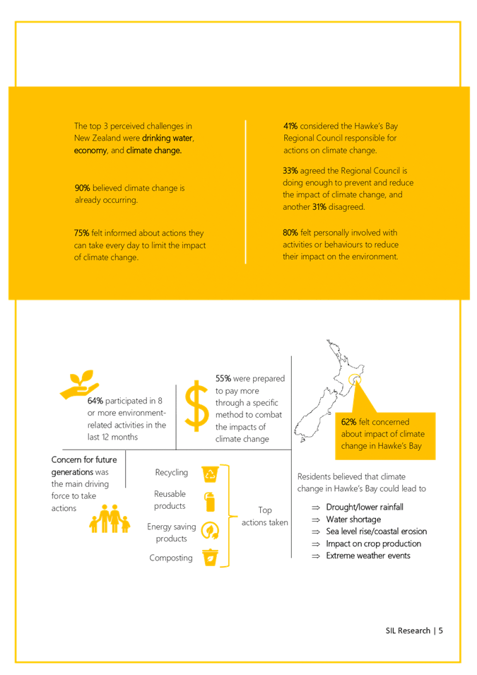
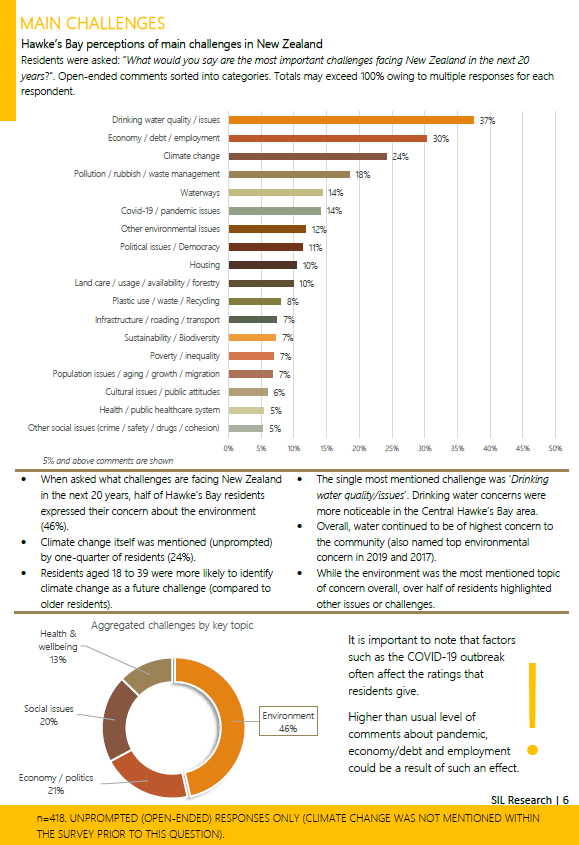
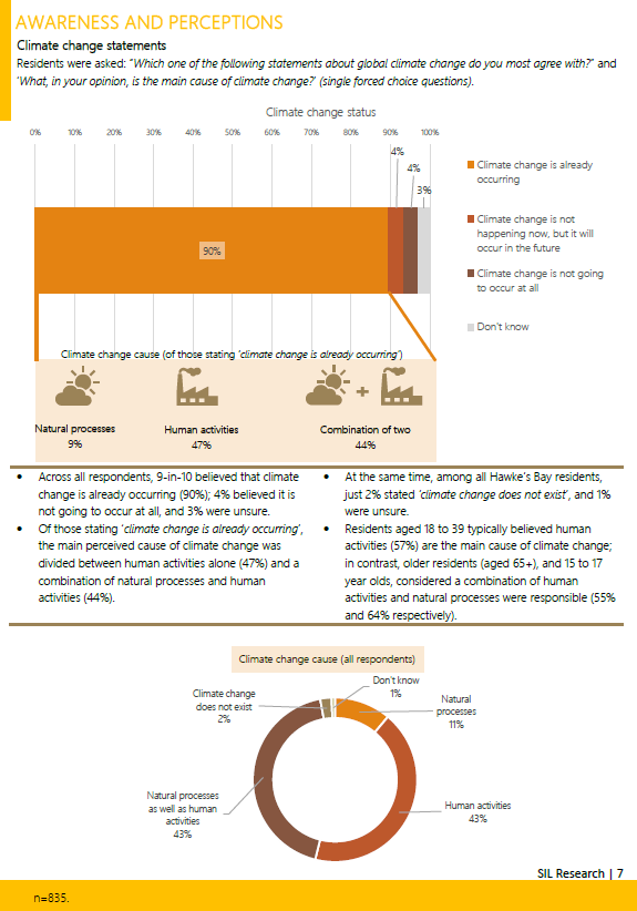

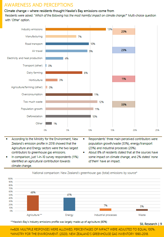
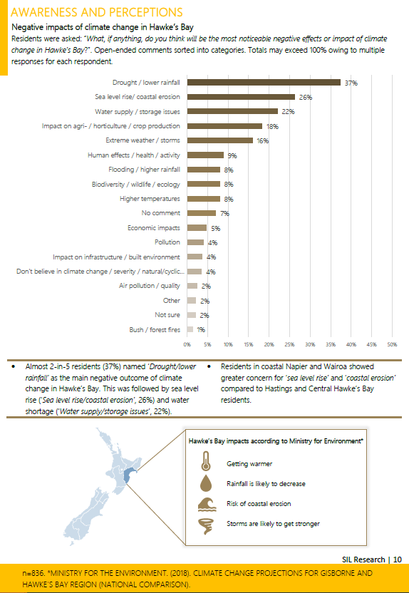
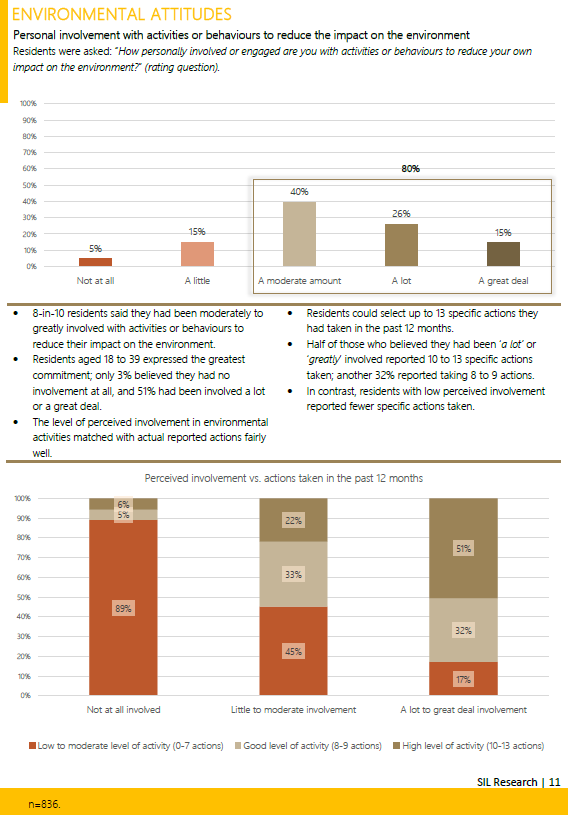
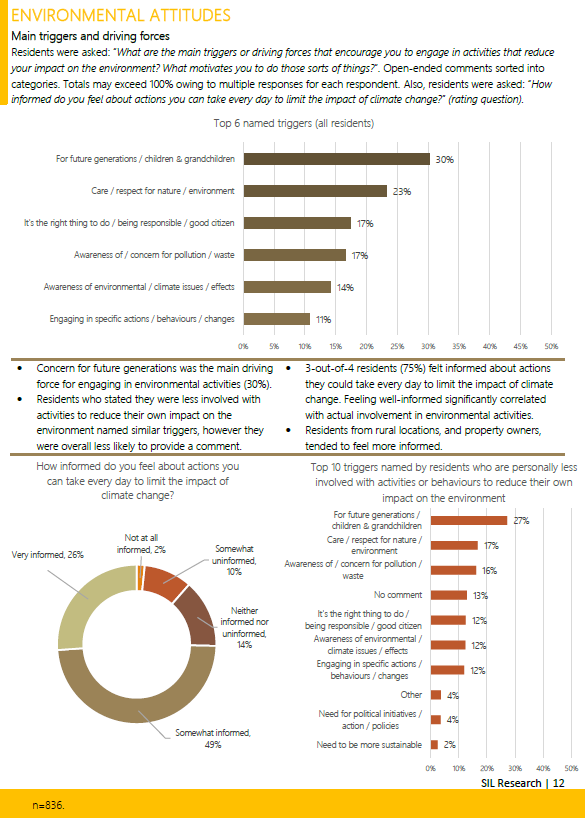
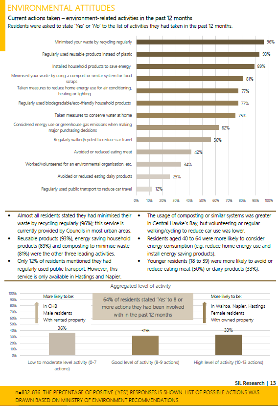
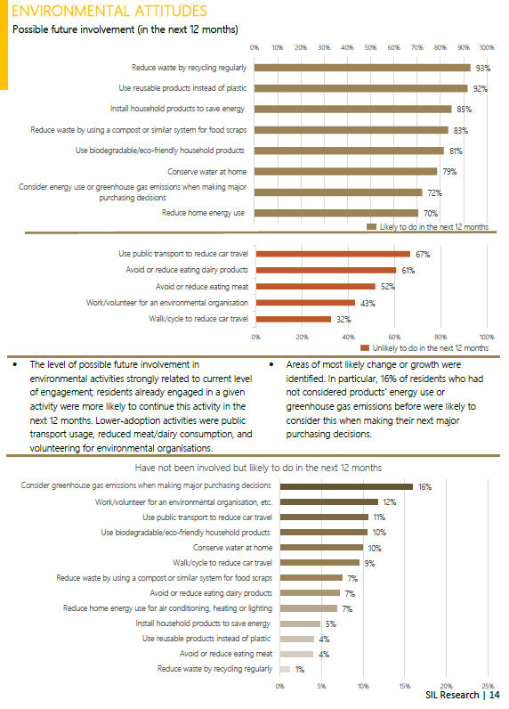
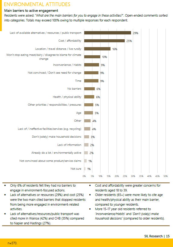
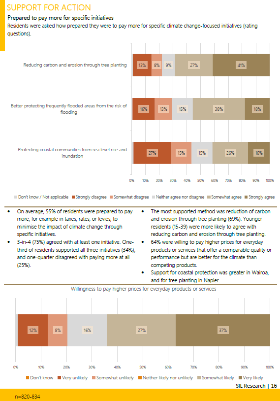
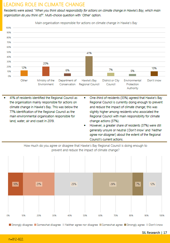
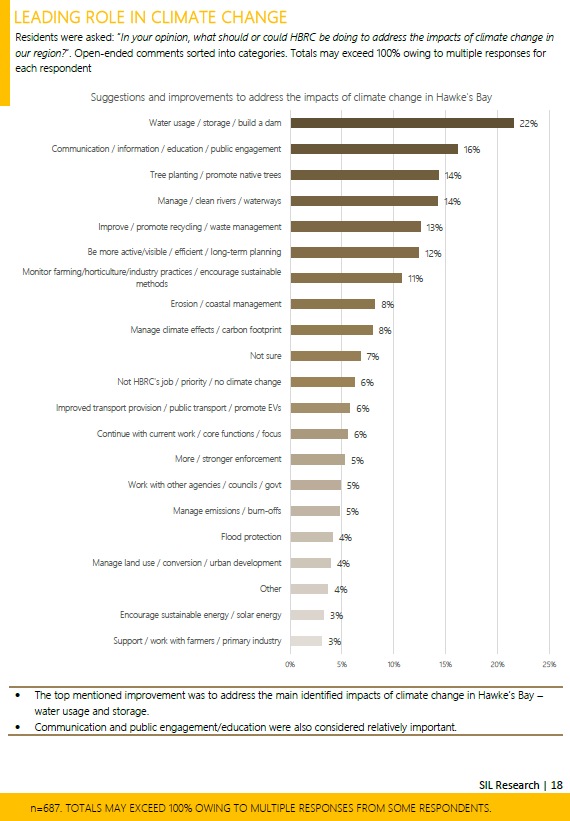
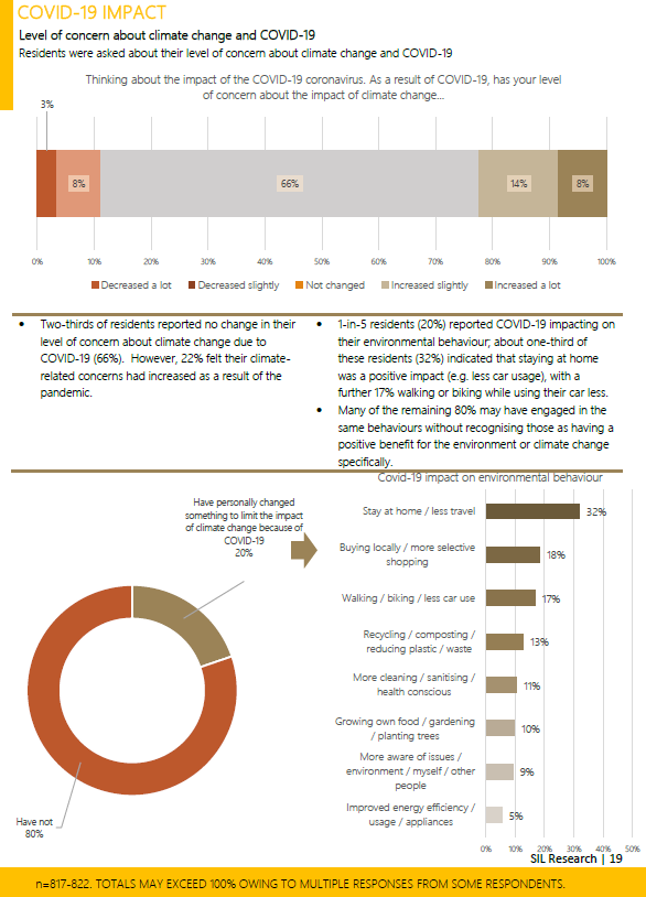
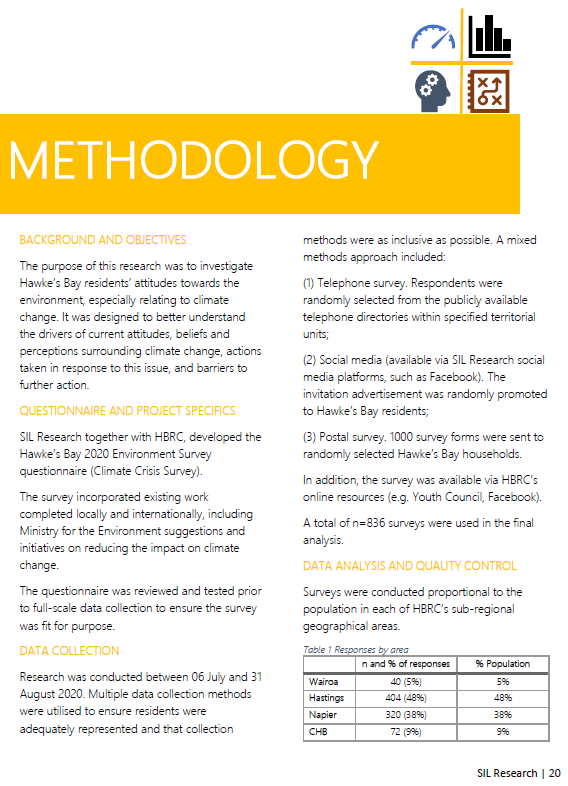
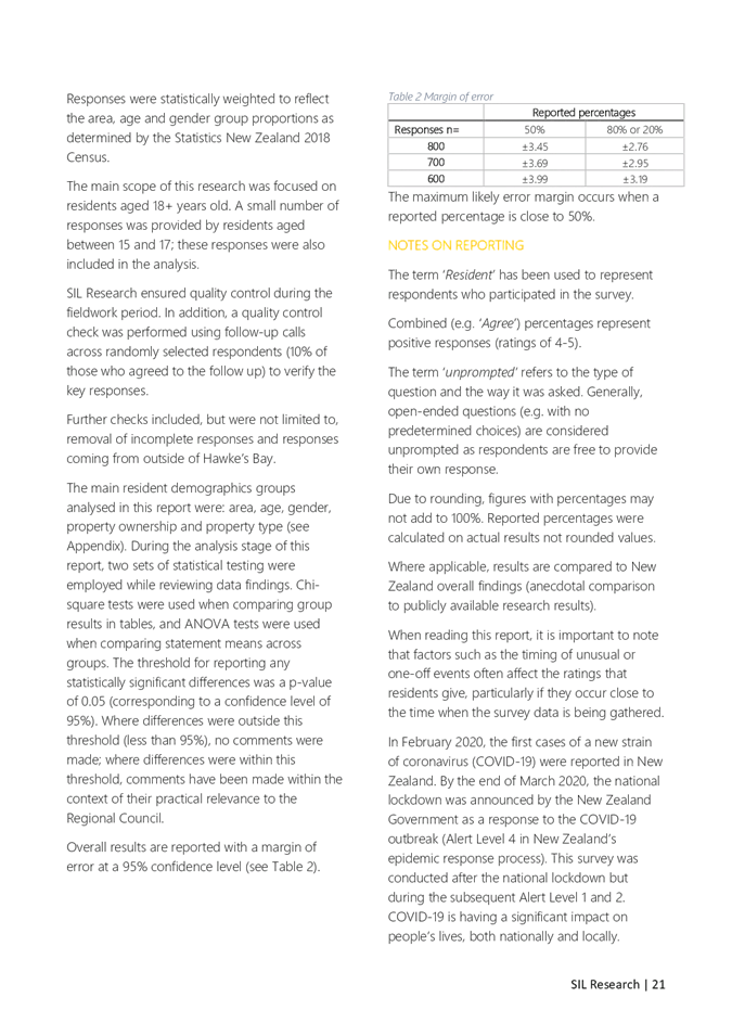
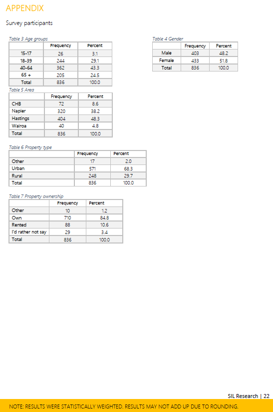
HAWKE’S BAY REGIONAL COUNCIL
Environment
and Integrated Catchments Committee
Wednesday 04 November 2020
Subject: Discussion of Minor
Matters Not on the Agenda
Reason for Report
1. This document has been prepared to assist
Committee members note the Minor Items to be discussed as determined earlier in Agenda Item
5.