Meeting of the Drought Committee
Date: Tuesday 10 March 2020
Time: 10.00am
|
Venue:
|
Council Chamber
Hawke's Bay Regional Council
159 Dalton Street
NAPIER
|
Agenda
Item Subject Page
1. Welcome/Notices/Apologies
2. Conflict
of Interest Declarations
Information or Performance Monitoring
3. Welcome from Rex
Graham, Chair, Hawke's Bay Regional Council
4. Indroduction from
Cr Will Foley
5. Situation update
from the Hawke's Bay Rural Advisory Group (HBRAG) 3
6. Situation
update: Hawke's Bay Regional Council Science Team 15
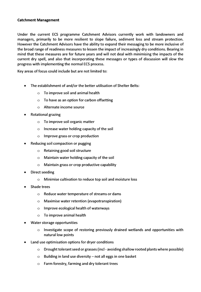
7. Catchment
Management Update - Dean Evans, Hawke's Bay Regional Council 23
8. Situation
update: Hawke's Bay Regional Council Regulation Team (verbal)
9. Situation
update: East Coast Rural Support Trust (verbal)
10. Roles and Responsibilities of
the Drought Committee
11. Aim for the Drought Committee
and mandate to act - Cr Will Foley (Background) 27
12. Are the right people in the
room?
13. Agreed Actions points
14. Next meeting date
HAWKE’S BAY REGIONAL COUNCIL
Drought
Committee
Tuesday 10 March 2020
Subject: Situation update:
Hawke's Bay Regional Council Science Team
Reason for Report
1. The Hawke’s Bay Drought Committee is meeting 9 March 2020 to
discuss the current extended dry period and to consider actions that may be
required to prepare for the possibility that the dry period may be prolonged
further.
2. This report is to inform the Committee on the current climatic and hydrological
status, along with a summary of the outlook and seasonal forecasts from various
models.
Discussion
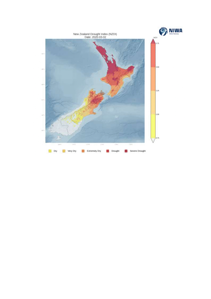
3. The NIWA New
Zealand Drought Index (NZDI) is updated every two days and as at 6 March,
when it was last updated, the NZDI showed dry conditions of varying severity
across the region. The driest areas were the Ruahine Range and surrounds
(Figure 1).
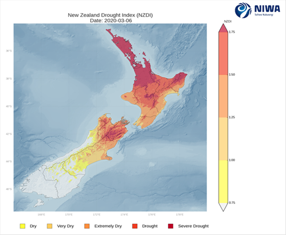
Figure 1: NIWA’s NZDI as at 6th March 2020 (source https://niwa.co.nz/climate/information-and-resources/drought-monitor).
4. Alongside the NZDI, NIWA’s soil moisture deficit map indicated
that the driest areas in Hawke’s Bay are on the Heretaunga Plains,
Central Hawke’s Bay and the region’s south coast (Figure 2 – map
on right).
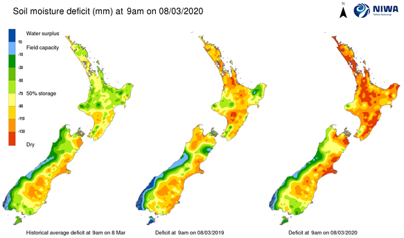
Figure 2:
NIWA’s daily soil moisture deficit map as at 8 March 2020 (source https://niwa.co.nz/static/climate/smd_map.png?1234)
5. Hawke’s Bay Regional Council monitoring up until the end of
February showed –
5.1 The Ruahine Range, Heretaunga Plains, Ruataniwha
Plains and southern coastal area experienced four months of below normal
rainfall (i.e. November to February inclusive). February totals in those
areas were approximately 10% of monthly averages, with only 2-18 mm recorded at
rainfall sites.
5.2 The Nov-Feb rainfall totals in the Ruahine Range
and Ongaonga area were the lowest recorded in the last 50-60 years.
5.3 Daytime temperatures in both Nov 2019 and
February 2020 were 3 °C warmer than the
respective monthly average. Average potential evapotranspiration (PET)
rates in those months were the highest recorded since monitoring began 10-15
years ago. December and January were also both 0.8 °C warmer than average. Sea surface temperatures
through February and the summer season were warmer than usual around Hawke Bay.
5.4 Cumulative rainfall minus PET at sites in the
Heretaunga and Ruataniwha Plains indicated that conditions were drier than
average at this point in the hydrological year (July to June) and also compared
to 2012-13.
5.5 Soil moisture was below average and in the
lowest 10th percentile in most of the region apart from
northern areas.
5.6 Many rivers and streams in the
southern part of the region were under water take bans.
6. Since the end of February,
the region experienced three days of rain and showers. The individual
site rainfall totals for seven days from 2 February are displayed in Figure
3. The highest totals were recorded in the north and in the western
ranges, though less so in the southern part of the Ruahine Range. Much of
Central Hawke’s Bay and the south coast received less than 10 mm.
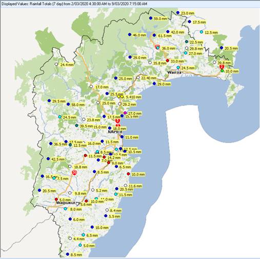
Figure 3: Site rainfall totals from 3rd March 2020 to midday
6th March 2020
Soil moisture
7. As at 9 March, soil moisture on both the Heretaunga and
Ruataniwha Plains (Figure 4) showed limited response to the rainfall and
remains at similar levels to those seen at the same time in 2012-13.
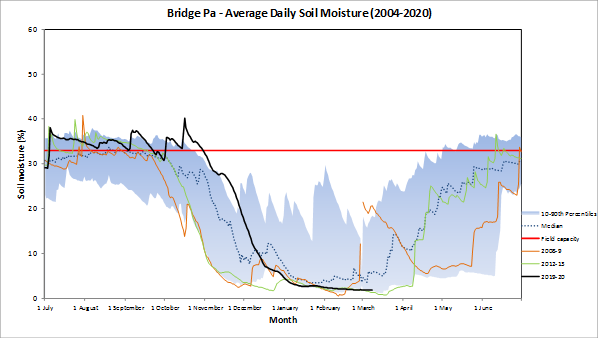
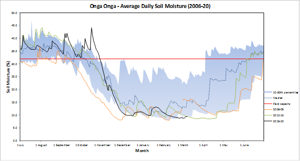
Figure 4: Daily soil moisture levels at Bridge Pa on the Heretaunga
Plains (top) and Ongaonga on the Ruataniwha Plains (bottom).
River flows
8. Flows measured in the Ngaruroro River at Fernhill and in the
Tukituki River at Red Bridge also remain within the lowest 5th
percentile of historical records (Figure 5).
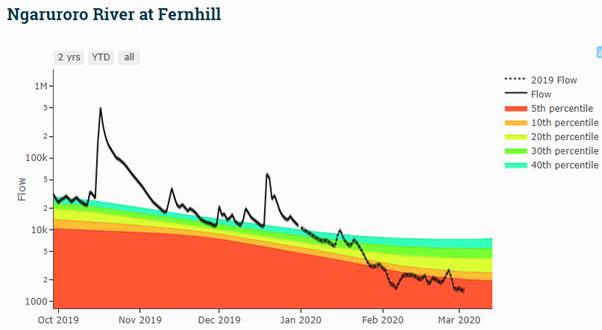
Figure 5: Daily mean river flows in the Ngaruroro River (upper plot) and
Tukituki River (lower plot).
Groundwater
9. While some groundwater levels during February 2020 remained normal
for that time of year, most levels were below normal or the lowest recorded
observation (Figure 6). Although some rain has fallen since groundwater
levels were measured in February, telemetered data indicate that groundwater
levels have merely stablised or experienced a small recovery. The
continuous groundwater level plot for Bridge Pa (Figure 7) is an example of
this. Hence, groundwater levels are currently expected to be similar to
the data shown in Figure 6.
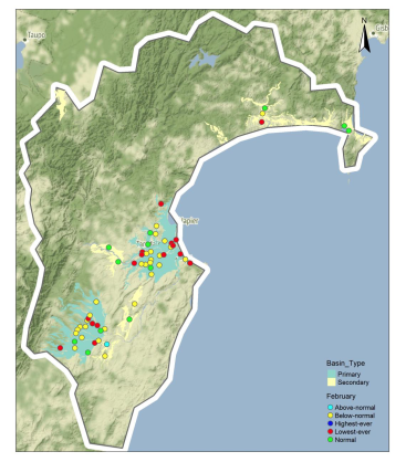
Figure 6: Regional groundwater levels during February 2020,
compared with historic groundwater levels for February. Wells with less than 5
years of record were excluded from analysis.
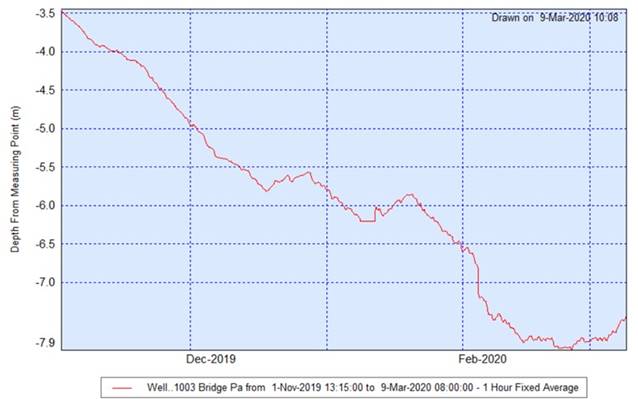

Figure 7: Telemetered groundwater level data from Well 1003 (Bridge Pa,
depth 9m below ground level), 1 November 2019 to 8 March 2020
Risk of saltwater intrusion to aquifer
systems
10. While
aquifer systems in Northland have been reported at risk of saltwater intrusion,
due to loss of aquifer pressure during the extended dry period, this is very
unlikely to be a risk for major aquifer systems in Hawke’s Bay. The
Ruataniwha aquifer system is inland and has no direct connection with the
coast. The Heretaunga aquifer system has considerable hydraulic head at
the coast (up to 10m above ground) and the groundwater is understood to
discharge to the ocean approximately 20km offshore. This means that
reduction of aquifer pressure during this extended dry period is highly
unlikely to cause saline intrusion to the major Heretaunga groundwater
resource.
Restrictions on surface water abstraction
11. The
recent rain enabled some bans on the Ngaruroro River to be lifted on 6 March
but on 9 March flow at the Fernhill site has again dropped below the trigger
flow for full ban (2,400 L/s). Extensive bans remain on rivers and
streams in Central Hawke’s Bay (Figure 8), with a full ban on the Tukituki
River at Red Bridge.
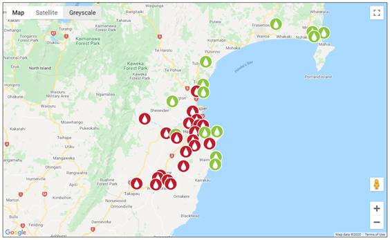
Figure
8: The status of bans on rivers and streams in Hawke’s Bay.
Red symbols indicate a ban is in force. (Sourced 9 March 2020 https://www.hbrc.govt.nz/environment/low-flows/)
Outlook
12. The
weather outlook in the short term, is for scattered rain or showers to start
the week. More significant rain is possible at the end of the week as a
low approaches the country from the northwest and an ex-tropical cyclone may
influence the country’s weather next week.
13. The three month seasonal forecasts (from NIWA, Metservice
and various forecast models) are for near normal rainfall and normal or warmer
than usual temperatures. ENSO is in neutral mode and is not a driver in
our weather currently. Tropical cyclone activity is currently subdued but
invigorates later in the week. Tropical systems have the potential to
disrupt the pattern of weather that has otherwise been dominant, whereby low
pressure systems move onto the southwest of NZ and weaken as they encounter a
ridge of high pressure over central and northern NZ. Any continuation of that pattern is a concern
and to date has contributed to the dry conditions.
Authored by:
|
Dr Kathleen
Kozyniak
Principal Scientist (Air)
|
Dr Jeff Smith
Manager Scientist
|
Approved by:
|
Iain Maxwell
Group Manager Integrated Catchment
Management
|
|
Attachment/s
There are no
attachments for this report.
HAWKE’S BAY REGIONAL COUNCIL
Drought
Committee
Tuesday 10 March 2020
Subject: Aim for the Drought
Committee and mandate to act - Cr Will Foley (Background)
Discussion
Hawke’s Bay Drought Committee
1. The Drought Committee is activated at times of severe drought in HB
to enable a coordinated response to the situation. Participants include
District Councils, East Coast Rural Support Trust, Ministry of Primary
Industries, and many stakeholders involved in the primary productive sector.
2. This Committee is facilitated by HBRC as part of its overview of
natural hazards for Hawke’s Bay and the Civil Defence Emergency
Management Joint Group.
3. During the 2012-13 summer drought the Committee was chaired by the
Regional Council Chairman.
4. Two representatives from Hawke’s Bay Regional Council were
appointed on 6 November 2019 to the Drought Committee, being Councillors
Will Foley and Jerf van Beek.
Authored by:
|
Annelie Roets
Governance Administration Assistant
|
|
Approved by:
|
Joanne
Lawrence
Group Manager Office of the Chief Executive
and Chair
|
|
Attachment/s
There are no
attachments for this report.

