Meeting of the Environment and Services Committee
Date: Wednesday 11 April 2018
Time: 9.00am
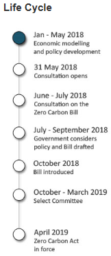
|
Venue:
|
Council Chamber
Hawke's Bay Regional Council
159 Dalton Street
NAPIER
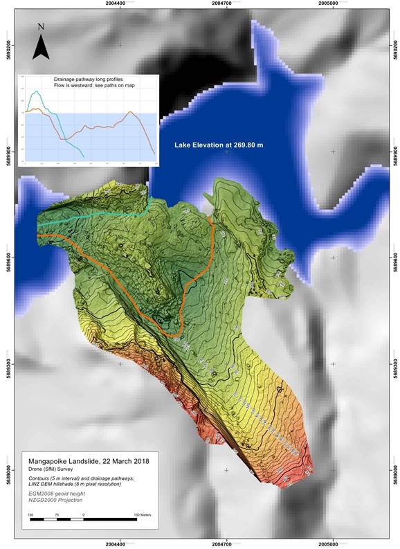
|
Agenda
Item Subject Page
1. Welcome/Notices/Apologies
2. Conflict
of Interest Declarations
3. Confirmation of
Minutes of the Environment and Services Committee meeting held on 21 February
2018
4. Call for Items of
Business Not on the Agenda 3
Decision Items
5. HBRC Enforcement
Policy Adoption Recommendation to Council 5
6. Process for
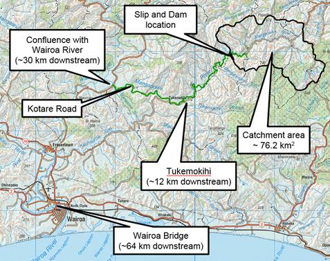
Awarding HBRC Certificate of Appreciation 7
Information or Performance Monitoring
7. April 2018 Hot
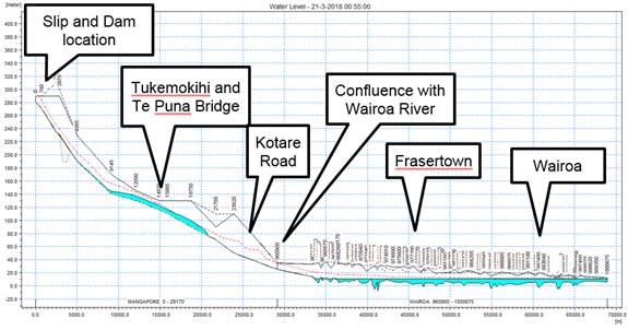
Spot/Freshwater Improvement Projects Update 11
8. Whitebait 15
9. Giant Willow Aphid
Update 19
10. Cycle Way Update – Mad
Mile 21
11. Mangapoike Landslide Update 25
12. Hawke's Bay Marine and Coastal
Group Roadmap 33
13. Taine Randell – Forest
and Carbon Presentation 10am
14. Zero Carbon 35
15. Summary of Hawke's Bay
Territorial Authorities' Key Long Term Plan Proposals 39
16. April 2018 Operational
Activities Update 41
17. Discussion of Items Not on the
Agenda 49
HAWKE’S BAY REGIONAL COUNCIL
Environment
and Services Committee
Wednesday 11 April 2018
Subject: Call for Items of
Business Not on the Agenda
Reason
for Report
1. Standing order 9.12 states:
“A meeting may deal with
an item of business that is not on the agenda where the meeting resolves to
deal with that item and the Chairperson provides the following information
during the public part of the meeting:
(a) the
reason the item is not on the agenda; and
(b) the
reason why the discussion of the item cannot be delayed until a subsequent
meeting.
Items not on the agenda may be brought before the
meeting through a report from either the Chief Executive or the Chairperson.
Please note that nothing in this standing order removes
the requirement to meet the provisions of Part 6, LGA 2002 with regard to
consultation and decision making.”
2. In addition,
standing order 9.13 allows “A meeting may discuss an item that is not
on the agenda only if it is a minor matter relating to the general business of
the meeting and the Chairperson explains at the beginning of the public part of
the meeting that the item will be discussed. However, the meeting may not make
a resolution, decision or recommendation about the item, except to refer it to
a subsequent meeting for further discussion.”
Recommendations
1. That
the Environment and Services Committee accepts the following “Items of
Business Not on the Agenda” for discussion as Item 17:
1.1. Urgent items of Business (supported
by tabled CE or Chairpersons’s report)
|
|
Item
Name
|
Reason not on Agenda
|
Reason discussion cannot be delayed
|
|
1.
|
|
|
|
|
2.
|
|
|
|
1.2. Minor items for discussion only
|
Item
|
Topic
|
Councillor
/ Staff
|
|
1.
|
|
|
|
2.
|
|
|
|
3.
|
|
|
|
Leeanne Hooper
GOVERNANCE MANAGER
|
Liz Lambert
GROUP MANAGER
EXTERNAL RELATIONS
|
HAWKE’S BAY REGIONAL COUNCIL
Environment
and Services Committee
Wednesday 11 April 2018
Subject: HBRC Enforcement Policy
Adoption Recommendation to Council
Reason for Report
1. To provide the
Committee with the HBRC Enforcement Policy as amended from feedback provided by
the Committee at the meeting on 21 February 2018, to enable a recommendation to
Council for adoption.
Discussion
2. At its meeting
21 February 2018 the Environment and Services Committee reviewed a draft of the
HBRC Enforcement Policy document.
3. As part of
providing assurance of HBRC’s decision making process, the policy
outlines the principles and guidelines that we apply and adhere to. This
includes transparency, consistency, fairness, proportional and evidence based
approach, laws and ethics, accountability, targeted compliance and responsive
and effective enforcement solutions.
4. Changes sought
at the 21 February Committee meeting, and now included for consideration are:
4.1. Insertion of
references to Council’s Strategic Vision and its RMA plans, and the
outcomes sought by those documents
4.2. Insertion of
a statement of intent for the policy that reflects HBRC’s intent to
encourage positive behaviour change in the first instance, and to ensure the
highest levels of compliance
4.3. Insertion of
reference to the role of political input into enforcement processes
4.4. Clarification
of the role the public can take in notifying HBRC of environmental breaches
4.5. Minor
formatting changes.
5. This document
will be a valuable reference tool for members of the public, Council staff
Councillors, and Environmental Officers. Once it is adopted by Council it will
be made available on the HBRC website.
Decision Making
Process
6. Council is required to make every decision in accordance with the
requirements of the Local Government Act 2002 (the Act). Staff have assessed
the requirements in relation to this item and have concluded:
6.1. The decision does not significantly alter the service provision or
affect a strategic asset.
6.2. The use of the special consultative procedure is not prescribed by
legislation.
6.3. The decision does not fall within the definition of Council’s
policy on significance.
6.4. The decision is not inconsistent with an existing policy or plan.
6.5. Given the nature and significance of the issue to be considered and
decided, and also the persons likely to be affected by, or have an interest in
the decisions made, Council can exercise its discretion and make a decision
without consulting directly with the community or others having an
interest in the decision.
|
Recommendations
1. The Environment and Services Committee receives and notes the “HBRC
Enforcement Policy” staff report.
2. The Environment and Services Committee recommends that Council:
2.1. Agrees that the decisions to be made are not significant under the
criteria contained in Council’s adopted Significance and Engagement
Policy, and that Council can exercise its discretion and make decisions on
this issue without conferring directly with the community and persons likely
to be affected by or to have an interest in the decision.
2.2. Adopts the April 2018 HBRC Enforcement Policy as provided.
|
Authored by:
|
Wayne Wright
Manager Resource Use
|
|
Approved by:
|
Liz Lambert
Group Manager External Relations
|
|
Attachment/s
|
⇨1
|
April 2018
HBRC Enforcement Policy
|
|
Under
Separate Cover
|
HAWKE’S BAY REGIONAL
COUNCIL
Environment
and Services Committee
Wednesday 11 April 2018
Subject: Process
for Awarding HBRC Certificate of Appreciation
Reason for Report
1. At the
Environment and Services Committee meeting held on 21 February 2018 staff were
requested to report back on a process to award, acknowledge and thank people in
the community for their efforts in helping Council to achieve positive outcomes
for the environment.
2. It is
acknowledged that Council does support environmental action in education
through our community engagement, and also acknowledges environmental
leadership in dairy farming through our nationally unique annual Dairy
Compliance Awards. In addition to this the Council sponsors the annual East
Coast Ballance Farm Environment Awards and is actively involved in the judging
of these awards, and periodically supports regional projects for recognition at
the national Green Ribbon Awards.
3. Research was
carried out through the regional sector group as to what other Councils are
doing in this space and this revealed that Taranaki Regional Council (TRC) is
the only regional council that hosts any formal environment awards process of
its own. Taranaki was broadly used as a template for this suggested process,
although in order to avoid overlap with existing initiatives and to minimise
additional costs to the Council, an annual awards ‘gala’ style
event with sponsors and monetary prizes (as is undertaken by TRC) is not
recommended.
4. It is suggested
that Council create three categories for nomination by Councillors being:
4.1. Te Taiao
me te Pakihi - Environmental Leadership in Business: Recognises
business or local authorities that demonstrate kaitiakitanga, innovation or
efficiency, or an ongoing commitment to environmental best practice.
4.2. Environmental
Leadership in Land Management: Recognises land users who are
committed to environmental stewardship and sustainability in their meat, fibre,
forestry or other land use operations.
4.3. Environmental
Action in the Community: Recognises not-for-profit organisations or
individuals that are taking action to protect or enhance the environment, or
are increasing understanding of environmental issues.
5. It is also
suggested that nominations are called for from Councillors at the Environmental
and Services Committee meetings in February and September each year using the
following guidelines for nomination.
5.1. The project
or activity must:
5.1.1. Make a
practical contribution to the sustainable management of Hawke’s
Bay’s natural resources or increase understanding and bring about change
on environmental issues
5.1.2. Be
sustainable over time and not require ongoing subsidy which is larger than the
benefit to the community
5.1.3. Be current,
ongoing or near completion
5.1.4. Be carried
out in the Hawke’s Bay region
ALSO
5.1.5. Previous
winners are eligible for nomination after a minimum of five years
5.1.6. Any
individual or organisation nominated should be considered suitable to promote
the integrity and good reputation of the awards.
6. Once nominees
are agreed then the acknowledgement is made at Council meetings in April and
November each year with the recipient, family and friends being invited to
attend morning or afternoon tea and the award being presented by the Council
Chair.
7. The suggested
award could be a framed botanical print including a plaque in recognition of
service to the environment.
8. This suggested
approach effectively has councillors acting as the ‘judges’ with
all nominees being awarded recognition. This is based on the presumption that
councillors are well placed to bring forward nominees given the nature of their
ongoing engagement with the community as elected representatives of
constituencies. An alternative approach would be to call for nominations from
the public and then a judging, selection or drafting process would likely be
required. In light of the resourcing implications of this alternative it is not
recommended as the proposed approach would deliver the same level of benefit
for less overall investment.
Financial and Resource Implications
9. The approach
proposed in this paper can be accommodated within existing governance and
communications resources. A more formal event would require reprioritisation of
existing budgets.
Decision Making
Process
10. Council
is required to make every decision in accordance with the requirements of the
Local Government Act 2002 (the Act). Staff have assessed the requirements in
relation to this item and have concluded:
10.1. The
decision does not significantly alter the service provision or affect a
strategic asset.
10.2. The use
of the special consultative procedure is not prescribed by legislation.
10.3. The decision
does not fall within the definition of Council’s policy on significance.
10.4. The persons affected by
this decision are all persons who may have a role
10.5. The
decision is not inconsistent with an existing policy or plan.
10.6. Given
the nature and significance of the issue to be considered and decided, and also
the persons likely to be affected by, or have an interest in the decisions
made, Council can exercise its discretion and make a decision without
consulting directly with the community or others having an interest in
the decision.
|
Recommendations
1. That the Environment and Services Committee receives and notes the
“Process for Awarding HBRC Certificate of Appreciation” staff
report.
2. The Environment and Services Committee recommends that Council:
2.1. Agrees that the decisions to be made are not significant under the
criteria contained in Council’s adopted Significance and Engagement
Policy, and that Council can exercise its discretion under Sections 79(1)(a)
and 82(3) of the Local Government Act 2002 and make decisions on this issue
without conferring directly with the community and persons likely to be
affected by or to have an interest in the decision.
2.2. Creates three categories for nomination to recognise environmental
stewardship, being:
2.2.1. Te
Taiao me te Pakihi - Environmental Leadership in Business:
Recognises business or local authorities that demonstrate kaitiakitanga,
innovation or efficiency, or an ongoing commitment to environmental best
practice.
2.2.2. Environmental
Leadership in Land Management: Recognises land users who are
committed to environmental stewardship and sustainability in their meat,
fibre, forestry or other land use operations.
2.2.3. Environmental
Action in the Community: Recognises no-for-profit organisations or
individuals that are taking action to protect or enhance the environment, or
are increasing understanding of environmental issues.
2.3. Calls for nominations to the above categories from Councillors at
the Environment and Services Committee held in February and September each
year with the Award being presented to the recipient at the April and
November Regional Council meetings with a morning or afternoon tea event.
|
Authored by:
|
Diane Wisely
Executive Assistant
|
|
Approved by:
|
James Palmer
Chief Executive
|
|
Attachment/s
There are no
attachments for this report.
HAWKE’S BAY REGIONAL COUNCIL
Environment
and Services Committee
Wednesday 11 April 2018
Subject: April 2018 Hot
Spot/Freshwater Improvement Projects Update
Reason for Report
1. To provide an update on progress on the Freshwater
Improvement/Hotspots environmental projects.
Background
2. The environmental ‘Hot Spot’ funding of $1m is to
accelerate action on six hot spots during 2017-18.
|
Ahuriri
|
Tukituki
|
Karamu
|
Marine
|
Tutira (FIF)
|
Whakaki (FIF)
|
|
$200,000
|
$100,000
|
$150,000
|
$150,000
|
$200,000 4 years
|
$200,000 5 years
|
Freshwater
Improvement Fund: Lake Tūtira (Te Waiū oTūtira, The Milk of
Tūtira), HBRC partnership with Maungaharuru-Tangitū Trust
3. The Project is now live. The Deed was officially countersigned by
MfE on 22 March 2018. Since then both the Project Team and Project
Governance Group have met with a focus on project objectives, activities and
timeframes.
4. Our first deliverable is creating an Integrated Catchment Management
Plan (ICMP) with the community. A working group met to outline a framework for
the ICMP. Contractor Billy Brough has begun work on the
ICMP, and we anticipate to have this completed by the end of August.
5. Land Science have started analysing the Tūtira Lake catchment
to identify high risk areas for sediment loss. This work is to be
completed before the end of May. The results will feed into both the ICMP and
Farm Environmental Management Plans (FEMP’s).
6. By the end of May existing FEMP’s will be reviewed and
templates created for the remainder of the Tūtira catchment.
7. By June a process will be created for the allocation of funds in the
Subsidy Scheme.
8. The re-connection of the Papakiri Stream is dependent on a meeting
request with key B-Block Landowners (Northern end of the Lake). By the
end of May, we will know whether the re-connection of the Papakiri is
achievable within the project timeframe (scheduled to be completed before the
end of June).
Freshwater Improvement Fund: Whakaki Lake (Sunshine, wetlands and bees will revitalise the taonga of Whakaki), HBRC partnership with Whakaki Lake Trust
9. The proposed additions (Waikatuku alignment and weir) to our FIF
stage two application have been approved by the Minister for the Environment,
subject to Council securing all consents prior to project commencement.
We require five consents across three project deliverables.
|
Deliverable
|
Year
|
Consents
required
|
|
Waikatuku
alignment
|
Year
1: March 2018-June 2018
|
Water
take diversion consent
|
|
Weir
|
Year
2: July 2018-June 2019
|
Land
use structure consent
|
|
Recirculating
wetland
|
Year
2: July 2018-June 2019
|
Surface
water take consent, Disturbance consent, Discharge contaminants to water
consent
|
10. Prior to
obtaining these consents, we planned to work with the community to refine the
design and delivery of our project deliverables. Our project budget included
$67,600, across five years, for community engagement. $12,500 of this is for
Year One (4 months), as we wanted to invest a significant amount of time in the
early stages of the project to work closely with the community.
Unfortunately these consenting conditions make this difficult, as MfE funding
is not guaranteed until a deed of funding has been signed by both parties;
noting any expenses incurred before this are not eligible for reimbursement.
11. MfE
acknowledge the additional funding condition will result in a delayed
commencement of the project, and they are happy to work with us to extend this
Stage 2 timeframe. Currently we are working on how to progress with Stage
2.
12. On 14
April, the Whakaki Lake Trust will be holding a hui with the community and
Iwitea to discuss ways forward to continue working with us on this project.
Hot Spot: Tukituki River
|
Tukituki
$100k
|
Project Lead
|
6,167 plants (approx)
|
1.57km fencing
|
|
$69k - Makirikiri restoration
|
Nicola McHaffie
|
2,200
|
530m
|
|
$29.5k - Hunt wetland
|
Joanne Hales
|
3,967
|
40m
|
|
$1.5k - Flood fencing demonstration
|
Brendan Powell
|
|
1km
|
13. The
Makirikiri restoration project. We have completed
the first and second rounds of weed control including the removal of
over-mature willow trees, and other weeds infestations in particular
blackberry. Fencing has been completed on the site and contracts are underway
for the planting. A whakawaatea hosted by the local marae occurred 11 February
2018 with councilors from both HBRC and CHBDC attending. HBRC are helping to
run visits with school groups to the site and are liaising with the marae and
the community to round up volunteers for the planting. Next steps: Works Group
to begin site preparation for the limestone path.
14. Hunt
wetland project is to restore a hectare of wetland,
situated alongside the Takapau Ormondville Road, back to native plants.
Currently this is area is in rank grass with minimal weed problems. The
first of the two stage spot spraying has occurred so long and dense grass
begins to break down in preparation for planting in the winter. The willows and
broom on the site have been removed, fencing and gate access for vehicles and
pedestrians have been erected and a pull over area created. Educational signage
will be erected at the site to describe the plants and the water quality
benefits of a wetland.
15. Flood
fencing demonstration behind Craggy Range. This
project demonstrates a flood fencing option for areas where permanent fencing
are unsuitable and are repeatedly wiped out by floods. The new fence was
installed on 21 March and consists of flexible fiberglass standards and
biodegradable polywire.
Hot Spot: Te Whanganui-ā-Orotu
(Ahuriri Estuary)
|
Ahuriri
$200k. Project
Lead: Anna Madarasz-Smith
|
|
$40k Ficopomatus
removal
|
|
$20k Ahuriri
Catchment Land Action Plan for sediment and nutrient control identifies high
erosion risk land within the catchment. (Action completed)
|
|
$100k Catchment
works
|
|
$40k Catchment
Hydrology
|
16. Ficopomatus
removal: To restore water flow between the upper
and lower estuary, we (in partnership with Mana Ahuriri Trust) removed 216
tonnes of invasive marine tubeworm from the estuary.
17. Catchment
works, identified through the Ahuriri Catchment
Land Action Plan, focus on landslide erosion (the major long-term source of
sediment) and streambank erosion (the regular and short-term source). We are
implementing erosion control measures, establishing wetland and riparian filters
and livestock exclusion from waterways.
18. The
recent flood has caused damages to some of the properties we are working
on. As these damages are a priority to fix, and will add cost to the
farmers, we have been working with them to revise our plans. This should not
make a significant difference to the programme.
|
Te Whanganui-a-Orotu
Project lead: Anna Madarasz-Smith
|
Plants
|
Fencing
|
Budget
|
|
14 properties in Ahuriri Catchment
|
5,575
(4,500 native / 1125 exotic)
|
7.1km
|
$100k
|
19. Catchment
Hydrology: Further research information is required
to better define the water budget, movement and export in this complex and
largely managed catchment. What are the contaminant pathways? How
much healthy freshwater does the estuary need to function. This is being scoped,
preliminary report due 9 April 2018.
Hot Spot: Te Karamū
|
Karamū
Project lead: Antony Rewcastle
|
10,725 plants
10,700 native / 25 exotic
|
1.65 km fencing
|
Budget
$150,000
|
|
06-00
Opaka, Karamū-Clive River
|
1000
|
155m
|
$12,500
|
|
16-50
Brookvale wetland enhancement, Mangateretere Stream
|
8000
|
500m
|
$90,000
|
|
29-00
Paki Paki enhancement, Hinetemoa Springs and Awanui Stream
|
1000
|
300m
|
$12,500
|
|
35-00
Bridge Pa fencing, Karewarewa-Paritu Stream
|
25
|
700m
|
$20,000
|
|
40-00
Kahurānaki (Te Hauke) Marae planting
|
700
|
-
|
$15,000
|
20. Opaka,
Old Ngaruroro (Karamu-Clive) River, left bank above
Whakatu Railway Bridge. Old man’s beard control completed.
Completion of silver poplar control and survey in progress. Fencing for stock
exclusion and revegetation planting to be completed.
21. Brookvale
wetland – Mangateretere Stream. Protection and enhancement of the stream to exclude stock and improve
water quality, habitat and biodiversity and demonstrate best practice land
management. Arboriculture work completed. Weed control in progress. Fencing
scheduled for April. Community planting day scheduled for 16 June 2018.
22. Paki
Paki enhancement - Hinetemoa Spring, Awanui Stream. Protection and enhancement of the waterway
to exclude stock and improve water quality, habitat and biodiversity for this
culturally significant site, which is visible as the southern entrance to
Heretaunga Plains. Fencing and revegetation enhancement planting in progress.
23. Paritua/Kārewarewa
Stream enhancement, Bridge Pa. Protection and enhancement of the waterway to exclude stock and
improve water quality on the Karewarewa-Paritua Stream, above Mangaroa Marae.
Tree work and fencing completed. Enhancement planting scheduled for June 2018.
24. Kahurānaki
(Te Hauke) Marae, Kahurānaki Stream. Working with representatives from the marae
to produce plans for weed control and enhancement planting on a tributary to
Lake Poukawa, and connection to biodiversity priority areas. Willow removal
complete, weed control in progress, planting scheduled for June 2018.
Hot Spot: Marine
|
Marine
$150k
|
Project Leads
|
|
$40k Hydrodynamic model of Hawke
Bay
|
Oliver
Wade
|
|
$110k Collaborative study: Wairoa
Hard
|
Anna
Madarasz-Smith
|
25. A Collaborative study
with NIWA, MPI and hapu looking at current state Wairoa Hard. This study
will use the NIWA vessel Ikatere to undertake multibeam echo sounder to define
the extent of hard substrate and potential habitats within the area. NIWA
have committed $35k of vessel time to the study, Ministry for Primary
Industries $25k, with the remaining $110k being funded by the HBRC Hotspot
fund. This 10 day mapping study is scheduled for April 2018, with further
work to be defined with PTSGs in the area.
26. Hydrodynamic model of
Hawke Bay: HBRC are working with model providers to understand various options
and create a scope of works. Port of Napier have agreed to provide us
with their input files. They are preparing this content for us.
27. Focus areas for modelling:
Cawthron Research Institute have completed their data analysis and are working
on a report for HBRC, expected end of May.
28. Boundary Conditions:
Currently MetOcean are generating a quote to provide HBRC with existing
boundary conditions information they have of the Hawke’s Bay.
29. Sampling Plan: We have
received two batches of water samples from GNS and NIWA. These are currently
being analysed at Hill Laboratory, Hamilton. We expect results in April.
Decision Making
Process
30. Staff have assessed the requirements
of the Local Government Act 2002 in relation to this item and have concluded
that, as this report is for information only, the decision making provisions do
not apply.
|
Recommendation
That the Environment and Services
Committee receives the “April 2018 Hot Spot/Freshwater
Improvement Projects Update” staff report.
|
Authored by:
|
Te Kaha
Hawaikirangi
Environmental Officer
|
Anna
Madarasz-Smith
Senior Scientist - Coastal Quality
|
|
Antony
Rewcastle
Senior Open Space Development Officer
|
Jolene
Townshend
Project Manager, Resource Management
|
|
Oliver Wade
Scientist
|
|
Approved by:
|
Dr Stephen
Swabey
Manager Science
|
Iain Maxwell
Group Manager Resource Management
|
Attachment/s
There are no
attachments for this report.
HAWKE’S BAY REGIONAL
COUNCIL
Environment
and Services Committee
Wednesday 11 April 2018
Subject: WhiteBAIT
Reason for Report
1. This report is in response to a request from Council to provide up
to date science, research and information on the policy/regulatory framework
around management and potential causes of stock depletion of whitebait species.
Background
2. The New Zealand ‘whitebait’ fishery typically involves 5
species of native, migratory galaxias. The 5 species are inanga, koaro, banded
kokopu, shortjaw kokopu and giant kokopu.
3. For all 5 species, the adult stage is spent in freshwater but the
3-6 month larval stage is typically spent in the ocean. The transparent
juveniles returning to freshwater are the target of the whitebait fishery.
Their migratory life history means different habitats are required for
different life stages, and all of these habitats need to be protected in order
for the species to flourish.
4. Whitebait runs appear to have drastically reduced since European
colonisation, with early anecdotes describing whitebait being used as
fertiliser.
5. It is difficult to assess the status of the whitebait fishery,
however, because official catch records are not collected and the fish species
involved are not estimated in a robust fashion. But, it seems likely that there
used to be a lot more whitebait around.
6. Most common hypotheses to explain their decline around New Zealand
relate to habitat alteration, swamp drainage, restricted access to suitable
habitat, competition with and predation by introduced species, and overfishing.
Management Roles
7. The whitebait fishery is managed by the Department of Conservation
as a recreational fishery. No license is required and there are no catch
limits, but restrictions on gear and fishing effort are used to create equal
opportunities to catch whitebait. Restrictions include a limited season;
fishing only allowed during daylight hours; a need for the individual to attend
their net; and restrictions on waterway obstruction. There are some no-take
rivers (akin to whitebait reserves) on the West Coast of the South Island. All
of the restrictions are designed to give fish an opportunity to escape, but it
is difficult to assess whether the measures are effective because few data are
collected.
8. Although whitebait is managed as a recreational fishery, there are
no laws to prevent individuals selling fish. Tonnes of whitebait are sold each
year by individuals in some parts of New Zealand (e.g. Southwest Fiordland and
the West Coast of the South Island). MPI regulate the food safety aspect of
catching and processing whitebait for sale. But there is no authority for MPI
to regulate the fishery component of the whitebait (e.g. through the quota
management system).
9. By contrast, MPI manages the commercial freshwater eel fishery
(shortfin and longfin eels) in a quota management system, as well as placing
catch limits on recreational anglers. So eels present an example of another
group of native freshwater fish targeted by fishing interests, but the eel
fishery is managed in a more formal manner in comparison to whitebait.
10. Another
contrasting example is salmonids, a group of exotic freshwater fish species,
strictly managed by Fish and Game. Salmonids in New Zealand include are brown
and rainbow trout and salmon species that are managed as recreational species,
with a very strong focus on quantitative fishery management, with tight
restrictions around seasons, gear and catch limits, as well as active stocking
programmes. Fish and Game also act as a strong lobby group for protection of
salmonid habitat.
11. According
to the New Zealand Conservation Authority, the whitebait fishery may benefit
from a tighter monitoring and regulatory framework, and they requested DOC to
consider this in 2017. But given that whitebaiting is a quintessential part of
kiwi culture, interfering with its present status may be unpopular.
12. Hawke’s
Bay Regional Council (HBRC) does not feature in the management of the whitebait
fishery directly. HBRC manages whitebait stands, because they are instream
structures that require a consent. This gives HBRC no direct power over fishing
regulations, but probably means HBRC has the most formal relationship with a
large group of whitebaiters of any of the agencies. HBRC also have clear
obligations around protecting habitat, maintaining the life supporting capacity
of waterways and preventing/mitigating barriers to fish migration, with these
actions indirectly impacting whitebait.
Issues for concern
13. Sediment
is a strong stressor on all life history stages. Larvae are visual feeders, and
suspended sediment in Hawke Bay decreases their feeding efficiency and
potentially decreases growth and survival. Juveniles actively avoid turbid
(muddy) water, indicating a preference for streams with less suspended sediment
in them. The adult stage of the 5 different species occupy different habitats,
but a reduction in fine sediment is likely to benefit all of them. High
sediment loads during floods can smother spawning grounds and decrease egg
survival.
14. Riparian
habitat management is also critical for whitebait species. An experiment by
NIWA demonstrated that stream reaches with good riparian habitat (cover and
instream woody debris) supported 4 times as many inanga as stream reaches with
poor riparian habitat. Proactive measures to increase the length of stream with
good riparian habitat will benefit whitebait species.
15. Barriers
to fish passage are a major threat to whitebait species because these interrupt
migration pathways and prevent individuals reaching suitable habitat. Inanga,
the main contributor to the whitebait fishery, is a weak climber and so is
particularly susceptible to barriers such as perched culverts. Tide gates and
pumping stations are also common in lowland reaches of waterways which is their
preferred habitat.
16. It is
unknown whether whitebaiting itself is a major threat to whitebait populations.
What can HBRC do?
17. A
decrease in hillslope erosion from afforestation should benefit all life stages
of the different species, and help enhance the whitebait fishery. Similarly,
riparian planting programmes will help increase bank stability, decrease
sedimentation as well as improve habitat conditions within streams.
18. Restoring
fish passage and protecting and enhancing aquatic habitat, including wetlands,
has significant potential to increase whitebait numbers, by essentially
increasing the habitat area available and thus the effective population size.
19. Identifying
and protecting inanga spawning habitat in upper reaches of estuaries should be
a particular focus, and Hawke’s Bay has been pioneering the
identification and protection of inanga spawning sites since the Catchment
Board days with the involvement of locals such as Hans Rook (retired-Department
of Conservation) who is passing his expertise onto tangata whenua. Active
programmes at HBRC are helping to continue these efforts. For example, Open
Spaces have been identifying spawning areas on HBRC owned land, identifying
potential spawning areas has been part of the Cape to City project, and the
Joella Brown and Hans Rook have been contracted to provide information on
potential inanga spawning areas for the TANK plan change.
20. One
optimistic aspect of the whitebait fishery is that it is primarily comprised of
inanga, which is an annual species, with individuals taking only 1 year to
reach sexual maturity. Restoring access to suitable habitat or enhancing or
creating new habitat will increase the carrying capacity of Hawke’s Bay
rivers for these species. Protecting and enhancing spawning grounds will maximize
spawning success. The short life history of this species will mean population
growth can be rapid – and therefore an increase in whitebait numbers
should theoretically occur quite quickly after improvements have been made.
21. Although
the whitebait life cycle is complicated and current management of the fishery
could be considered deficient, there are many things HBRC can and will continue
to do to contribute to an increase in whitebait numbers.
Decision
Making Process
22. Staff have assessed the
requirements of the Local Government Act 2002 in relation to this item and have
concluded that, as this report is for information only, the decision making
provisions do not apply.
|
Recommendation
That the Environment and Services
Committee receives and notes the “Whitebait” staff
report.
|
Authored by:
|
Dr Andy Hicks
Team Leader/Principal Scientist - Water
Quality and Ecology
|
|
Approved by:
|
Dr Stephen
Swabey
Manager Science
|
Iain Maxwell
Group Manager Resource Management
|
Attachment/s
There are no
attachments for this report.
HAWKE’S BAY REGIONAL
COUNCIL
Environment
and Services Committee
Wednesday 11 April 2018
Subject: Giant Willow Aphid
Update
Reason for Report
1. To provide the Committee with an update on Council’s response
to Giant Willow Aphid infestations on the flood protection scheme assets for
the 2017/18 Summer season.
Background


2. The giant willow aphid, which measures 5-6mm, was first sighted and
reported in Auckland in December 2013 and quickly spread throughout the North
Island and as far south as Clyde in Central Otago. Willows are its only
recognised host plant. It taps into the sugar flow in the stem and the pressure
of sap through the aphid produces honey dew.
3. Higher than normal numbers of wasps are likely indicators of aphid
infestation as they feed on the honey dew. Bees also harvest the honey dew,
which can change the characteristics of their honey including raising its
melting temperature and causing discoloration. It is difficult not to miss the
sight of blackened willows along the rivers. The blackening is sooty mould,
which feeds on the honeydew deposited on leaves and branches by the feeding
aphids and is denoted as a black layer on the top of the willow branches and
leaves.
Scheme Infestation
4. Since Giant Willow Aphid was discovered in our region in 2015, staff
have been monitoring and recording the infestations and affected areas. The
summer of 2015/2016 was particularly bad with large areas infested both within
and outside the flood control scheme areas.
5. In the summer last year (2016/2017) Giant Willow Aphid were evident
in all of our major rivers edge protection willows again, but infestations were
not as bad as experienced in 2015/16 due to strong winds early in Spring which
resulted in a late start to infestations and consequently less of a problem
overall and tree health not as badly affected. These trees recovered over
spring 2017 and early summer.
6. This summer (2017/2018) Giant Willow Aphid seems to be re-occurring
again in all locations with some areas more affected than others. Observations
are that the infestations are not nearly as bad as 2015/2016 with aphid numbers
on each tree much more dispersed and less numerous than previously. The
infestations have appeared later in the season this year, presumably due to
similar climate conditions as experienced in 2016/17.
7. Our concern with this particular plant pest is the unknown effects
of the longer term impact of the aphid. The concern relates to potential
weakening of the trees, particularly around the root holding capacity of the
trees, which is a primary requirement for flood control purposes. While the
trees are surviving the initial infestation progressive weakening of the trees
is being monitored, as experienced with the Sawfly outbreak in early 2000. Work
is ongoing with the Willow and Poplar Plant Material Collective looking at
solutions to the problem with current advice still to monitor annual
experiences and encourage the planting of alternative or resistant species.
8. One area of concern in the HPFCS that we are watching closely is the
Ngaruroro right bank Ormond to Carrick Road where last year 2700 willow poles
were planted. Most of these poles have some Giant Willow Aphid on them, as do
the older willows. To provide additional security to the edge protection works,
1000 Alders will be planted landward of the pole planting. This is in line with
current works to strengthen the willow planting with suitable alternative
exotic and natives species.
9. There has been a short section with dead willows downstream of
Fernhill to Maori Point, although the reason for the dead trees is unknown. At
this stage we have no evidence that their demise is due to aphids and is more
likely an age and stage issue. This area, will be replanted with willows and it
has a good coverage of exotic and native trees and so is of less concern.
10. Giant
Willow Aphid have been found throughout the Upper Tukituki scheme but to a much
lesser extent above SH50 this year. The main area of infestation is the
Tukituki from Rathbones Bridge to Burnside Road on both sides, but again not as
bad as previous years. The poles planted this season show no sign of Giant
Willow Aphid at all. On the Waipawa River there is evidence of aphids but
nowhere as bad as previous years.
Discussion
11. In
summary Giant Willow Aphid remains a problem and field staff will continue to
monitor and record the extent of the affected areas. Unlike the devastating
Willow Sawfly problem where willow trees died on mass, staff are quietly
confident at this stage that the willows are coping with the aphid infestation.
It is still a waiting game to some extent to see how repeated infestations will
affect the health of the trees.
12. Nevertheless,
we need to be vigilant and have back-up provisions to maintain the integrity of
the flood protection assets. The current levels of service review for the
schemes will include more extensive use of groynes that were designed and
tested as part of the sawfly remediation works. This will place less reliance
on the willows in critical locations.
Decision Making
Process
13. Staff have assessed the
requirements of the Local Government Act 2002 in relation to this item and have
concluded that, as this report is for information only, the decision making
provisions do not apply.
|
Recommendation
That the Environment and Services
Committee receives and notes the “Giant Willow Aphid
Update” staff report.
|
Authored by:
|
Gary Clode
Manager Regional Assets
|
|
Approved by:
|
Graeme Hansen
Group Manager Asset Management
|
|
Attachment/s
There are no
attachments for this report.
HAWKE’S BAY REGIONAL
COUNCIL
Environment
and Services Committee
Wednesday 11 April 2018
Subject: Cycle Way Update
– Mad Mile
Reason for Report
1. To provide Councillors with background information on a significant
health and safety issue on a section of the Landscapes ride referred to as the
‘Mad Mile’ and an update on progress finding a solution.
Background
2. HBRC has developed nearly 200km of mostly off road cycle trails
since 2009 with Hawke’s Bay being one of the most popular of the
twenty-two New Zealand Cycle Trail (NZCT) ‘Great Rides’. They
include approximately 185km of mostly off-road trails, owned or managed by
HBRC, which is a significant asset to HBRC and the region. The trails have a
New Zealand Cycle Trail ‘Great Ride’ status for Grades 1-3,
providing the easiest riding experience. It has been estimated that over
600,000 individual trip counts were taken on the trails in 2017, with a mix of
local, domestic and international visitors using Hawke’s Bay Trails.
3. Within the Landscapes ride, is a short section referred to as the
‘Mad Mile’ - between River Road and Craggy Range Winery adjacent to
Waimarama Road. This section was not able to be constructed off road, as
proposed in 2009, due to the lack of land access.
4. As a result cycle trail users must use an on-road section to
complete the ‘Tukituki Loop’ - resulting in an experience that is
out of context with most other sections of trail, does not meet NZCT’s
Great Ride standard, and which is a significant safety risk. The current
situation has trail users negotiating a narrow open road (80 km/h) section,
with high traffic counts, with very little shoulder in places, on a hill
climb/descent that is unsafe and not within the Hawke’s Bay Trails trail
grading.
5. A report (February 2015) produced by Hastings District Council
outlined issues with this section of trail. Some modifications have been made
by HDC to improve safety in the interim:
5.1. Reduce speed limit from 100km/hr to 80km/hr
5.2. Double yellow line for no passing in this area (this reduced the
road shoulder)
5.3. Fluoro yellow and black ‘Cyclist’ signage and
‘Share the Road’ signs.
Figure 1. Start of Waimarama Road and of Mad Mile Section
6. While an initial improvement, these measures have proven to be
insufficient to the NZCT Inc. Board who requested a temporary closure of this
trail section on 17th March 2017 – until a suitable solution is found.
7. The specific trail section, is on Waimarama Road, from River Road/Te
Mata Road intersection up and over the crest of the hill and down to Craggy
Range Winery off-road paved trail – approximately 2km long.
8. This project’s objective is to build a suitable safe off-road
alternative, within NZCT Design standards of Grade 2-3 off road specifications
to solve this safety issue and have this section of trail re-opened and remain
as part of the Landscape ride and Tukituki loop.
Options considered
9. In 2016 it was suggested to remove a significant section of the
Tukituki loop from River Road to Red Bridge to Moore Road (approx. 13km) and
build a bridge over the Tukituki River, to link the off-road trails.
Feasibility studies indicated a suspension bridge would be in excess of 260m
length, which is considerably longer than any other cycle bridge constructed in
NZ. It was estimated it would cost between $1.5m-$2m to build. Comparison costs
of recent NZ cycle/walking bridges:
9.1. The Waikato River Bridge built in 2016 is 130m long, 3m wide, 18m
high and budgeted cost $1.3m – actual cost $2.1m
9.2. The Timber Trail, Maramataha Bridge built in 2012 is 141m long, 2m
wide approx. and cost $500k.
10. Due to
these challenges and costs it was considered prudent to revisit previous
options from HBRC and HDC considered in 2015, these included:
Option 1 Off-road trail adjacent to Tukituki River to connect to existing
trail at Craggy Range
Option 2 On-road widening of Waimarama Road
Option 3 Off-road trail Te Mata Peak side Waimarama Road 1300m
Option 4 Bridge and off-road trail to Red Bridge on Tukituki road side only
Option 5 Bridge and off-road trail to connect to existing trail at Moore Road
Option 6 Off-road two way shared path beside Waimarama Road
11. Options 1
and 4 were discounted due to the challenges of achieving landowner approvals.
12. Options
2, 5 and 6 were discounted due to total project costs.
13. Option 3
has been progressed due to a willing landowner negotiation for land purchase,
affordable costs and achieving the health and safety objectives and meeting
NZCT trail standards.
Option 3
14. Project
Solution: Create a dedicated off-road lime sand trail on private land on the Te
Mata Peak side of Waimarama Road, linking to the existing off road section of
the Landscapes ride. (This follows the existing on road trail but takes users
off-road, parallel to road)
15. HBRC has
negotiated an arrangement to purchase land from a single landowner beside
Waimarama Road, which will be vested as road reserve upon deposit and create a
dedicated limesand trail on this road side land. This trail will be above the
road, thus linking similar off-road sections and avoiding the dangers of using
the road corridor.
16. This
preferred solution includes collaborating with Hastings District Council, which
will create a connecting off-road trail from opposite River Road to the new
proposed section with land easements in place. The new trail exit will connect
at the bottom of the hill adjacent to Craggy Range Winery, connecting with the
existing paving trail on Waimarama Road.
17. This
section of trail needs to comply with NZCT design standards, so will have a
steady gradient, be off-road and suitable for all trail users. The construction
requires culverts to traverse gullies and a board walk over a natural bog area.
A tree-planting plan is included in the design and will help to stabilise land,
enhance the ride experience and create a natural bird corridor, as agreed with
the landowner.
18. Rest
areas will also incorporate appropriate signage covering local and Maori
history of the area.
19. Recent
controversy and confusion associated with the Craggy Range trail, which is
coincidentally in the same area, has provided challenges for progressing the
Landscapes trail solution. We currently have an agreed sale and purchase
agreement with the landowner, an approved design solution and plans for
planting and construction, along with construction commitments. A residual
issue to progressing this project is a requirement that staff confirm that
governors of HBRC, HDC and Iwi are aware of this project. This paper is to
confirm that awareness.
Budget
20. This
section of trail is estimated to cost $340,000 with funding committed from
HBRC, MBIE, HDC, and Eastern and Central Community Trust. HBRC
successfully applied to MBIE for this to be funded as a ‘Priority
Project’ due to the NZCT Trail safety requirements and, based on the
above project solution, have secured funding for half the cost of this project.
HBRC would contribute $85,000.00 to the solution and this funding is provided
for in existing 2017-18 budgets.
Decision Making
Process
21. Staff have assessed the
requirements of the Local Government Act 2002 in relation to this item and have
concluded that, as this report is for information only, the decision making
provisions do not apply.
|
Recommendation
That the Environment and Services Committee
receives and notes the “Cycle Way Update – Mad Mile”
staff report.
|
Authored by:
|
Vicki
Butterworth
Cycle Network Coordinator
|
|
Approved by:
|
Graeme Hansen
Group Manager Asset Management
|
|
Attachment/s
There are no
attachments for this report.
HAWKE’S BAY REGIONAL
COUNCIL
Environment
and Services Committee
Wednesday 11 April 2018
Subject: Mangapoike Landslide
Update
Reason for Report
1. To update
committee on the situation at the Mangapoike landslide, and to identify what
actions are proposed in the near future, with a further update of any changed
circumstances on this developing activity to be provided on the day.
The Situation
2. On or about 25
February 2018, a landslide totalling approximately 11.5 million tonnes of rock
and clay was initiated in a valley on the true left side of the Mangapoike
River. An 8 million tonne block of material slid northwards along a joint
plane to block the Mangapoike River, which is tributary of the Wairoa River.
3. The event that
triggered instability in the landslide is likely to have been a 4.3M earthquake
centred about 17 km WSW of the site on 5 February 2018. The Waimaha rain
gauge nearby in Gisborne District recorded 143 mm of rain in February, largely
in the first half of the month (Figure 1). This rainfall will have lubricated
the slip during its subsequent rapid failure.
Figure 1: Daily rain
(mm) at Waimaha during February 2018
4. The rapid
movement of the slip may have been recorded as a shallow 2.2M earthquake at an
epicentre several kilometres away at 10:46 pm on 25 February 2018. The slip
moved quickly enough to cause air blast and to overtop spurs as it moved. Part
of the slip is in the Gisborne District and part is in the Wairoa District of
Hawke’s Bay Region (Figure 2).
5. The slip dammed
the Mangapoike River at Mangapoike. The river subsequently began to form a lake
(Lake Mangapoike) behind the slip. Most of the lake is in the Gisborne
District, but part is in the Wairoa District, Hawke’s Bay Region (Figure
2).
Figure 2: Landslide dam
(slip) and lake behind the slip (Lake Mangapoike) on the boundary (pink)
between Wairoa District (Hawke’s Bay Region) and Gisborne District
6. Access
to the area is difficult, and visits to the lake by road from Hawke’s Bay
must be made by a long detour through the Gisborne District.
7. The
Gisborne District Council (GDC) has been leading the investigation into the
landslide dammed lake by agreement with HBRC, by monitoring the lake’s
growth and depth, and by monitoring the stability of the landslide material.
8. The
risks associated with the landslide dam and the dammed lake are flooding of
land upstream (mostly in the Gisborne District) and sediment and water
discharge below the landslide dam (mostly in the Wairoa District).
The Response
9. Hawke’s
Bay Regional Council, Wairoa District Council (WDC) and the Hawke’s Bay
Civil Defence Group have collaborated with Gisborne District Council to
undertake civil defence activities, including working with the farms upstream
of the landslide dam as the lake grows in area, and notifying landowners
downstream of the landslide dam about the incident and actions being taken.
10. In the weeks following initial formation of the lake,
Gisborne District Council undertook various field visits, including oblique
(Figure 3) and aerial photography and mapping of the slip and the lake (Figures
4 and 5).
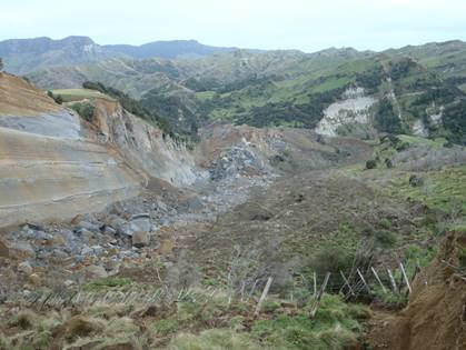
Figure 3: The
Mangapoike slip looking north-west towards the Mangapoike River/landslide dam
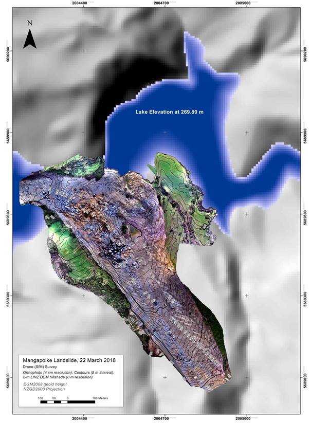
Figure 4: Aerial
photograph of the landslide dam on 22 March 2018
Figure
5: Potential pathways by which water may drain from Mangapoike Lake over (red)
or through (blue) the landslide dam
11. Initial
assessment undertaken by HBRC staff identified that the broad spread of the
slip meant that it was relatively stable and unlikely to fail rapidly or catastrophically.
12. To understand the potential future risk to people and
property from an overtopping dam, HBRC contracted Ian R Brown and Associates
(IRBA), an engineering geology firm, to assess stability of the landslide dam.
13. IRBA visited the landslide dam and Lake Mangapoike on 21
and 22 March 2018. IRBA’s visit was managed by Gisborne District Council,
but the contract work is funded by HBRC, reflecting the shared nature of the
hazard.
14. At the same time IRBA visited the site, University of Auckland
mapped the landslide and the lake. University of Auckland found that the
landslide had a volume of about 2.4 million tonnes of material deposited
to block the Mangapoike River, and a total of about 11.5 million tonnes of
material had moved.
15. The volume of water impounded by the landslide dam was
approximately 5 million m3 on 22 March 2018 (Figure 6), and that
about 6.3 million m3 of water could be impounded before
the dam overtopped (Figure 7).
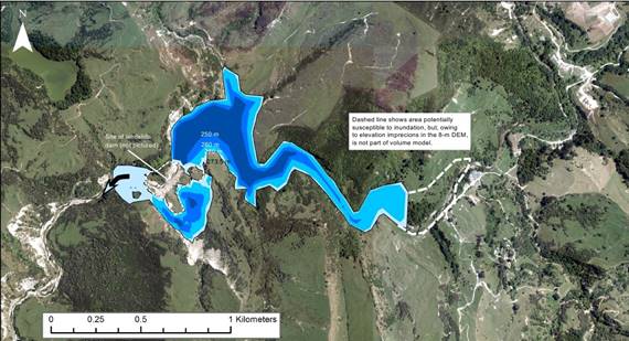
Figure 6: Assumed bathymetry of landslide-dammed Lake Mangapoike
16. The water level in Lake Mangapoike was at 270 m on 22 March
2018. It was expected that water would overtop into the lower part of the
landslide dam when the water level reaches 273.5 m, within a week (Figure 7).
This subsequently occurred on 2 April 2018.
17. The assessment by IRBA concluded that the landslide dam has
a broad base, which enhances the dam’s stability. However, IRBA noted
that landslide dams generally are short lived because water overtops them and
seeps through the dam core. There are exceptions to this, such as Waikaremoana
and Tūtira.
18. IRBA suggested the chance of catastrophic failure of the
landslide dam as no more than 10%. However, the landslide mass moved on a low
angle frictionless surface that may allow further movement.
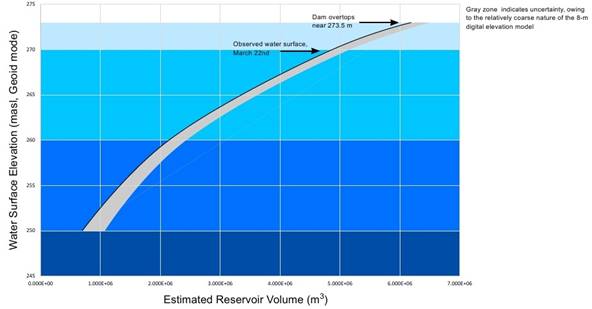
Figure 7:
Relationship between water level and reservoir (lake) volume
19. IRBA made 5 recommendations, which were:
19.1. Link the upper ponding area (the main body of the lake in
Figure 6) with the lower ponding area (the southern area of the lake in Figure
6, not yet full of water) with a constructed channel
19.2. Cut a spillway over the landslide dam and armour it to
control incision
19.3. Investigate the dam toe for points where it discharges
through the body of the dam, and monitor these
19.4. Investigate the landslide scarp for further cracks, and
restrict access to the site
19.5. Inspect slopes around the lake for cracking induced by the
rising water table, and any evacuate any affected occupied structures
20. Action 1 was completed on 29 March 2018 by GDC. Water
started moving from the upper ponding area to the lower ponding area on 3 April
2018.
21. Action 2 was initiated by HBRC on 30 March 2018 by
arranging to walk a digger to the slip location along the old Wairoa to
Gisborne highway through Tukemohiki Station. On 4 April 2018 a site visit to
see where the spillway could be dug was undertaken by GDC, WDC and the digger
contractors. This visit identified that it would be more suitable to use
explosives to construct the second spillway. This work was scheduled for 6
April 2018.
22. On 4 April 2018, approximately 10 days of inflowing
water could be accommodated before Mangapoike Station infrastructure began to
be affected. The water level had risen to 1.4 m below the bridge deck level on
Mangapoike Station.
What
Might Happen
23. The landslide dam may experience three possible
future scenarios:
23.1. The landslide dam remains stable, and water
exits from the dam by overtopping or through the dam core
23.2. The landslide dam is overtopped by the water
behind the dam and fails slowly by incising a channel through the dam material
23.3. The landslide dam fails rapidly by mass movement
induced by high water pressures in the dam core and by lubrication of the base
of the dam
24. The least likely scenario is scenario 3 –
sudden and rapid failure of the landslide dam. IRBA assess that this has a
likelihood of less than 10%. However, this scenario has potentially the most
severe consequences.
25. To understand what might happen if the water
impounded in Lake Mangapoike was released suddenly in the most severe scenario
(3), HBRC river engineers created a simple flood model for the catchment, and
routed a dam-break event through the Mangapoike River and Wairoa River (Figure
8).
Figure
8: Key locations in the Mangapoike River dam break modelling analysis
26. This flood modelling used a discharge scenario
from the dam of 10,000 m3/s. For comparison, a 2% (1:50 year) flood
event in the Wairoa River is about 4,350 m3/s at the railway bridge.
The discharge was modelled to occur very rapidly, as happens when a landslide
dam fails. In this scenario, high levels of discharge begin 20 minutes after
the event starts, and peak 30 minutes after the event starts.
27. In the modelled scenario, the pulse of water
released from the dam would reach Tukemokihi (Figure 8) in about 15 minutes,
and would probably cover the Te Puna bridge at that settlement. It is not known
whether the houses and other buildings at Tukemokihi would be affected by a
flood in this scenario. The Kotare Road bridge – a few kilometres
further downstream – would probably also be covered by a flood of this
magnitude.
28. As any flood wave travels down a river it is
flattened out by interaction with the bed and banks. Since the rivers in this
catchment are mostly well-incised into their floodplains, the modelled
landslide dam failure would be contained within the banks of the Mangapoike and
Wairoa rivers in almost all locations (Figure 9).
29. This means it is unlikely that sudden failure of
the landslide dam will adversely affect settlements downstream. Nonetheless,
large flows and sediment discharges still could occur, and river activities
such as fishing and boating should be discouraged downstream of the landslide
dam until the hazard has been assessed as very low.
Figure
9: Modelled landslide dam break in the Mangapoike River and Wairoa River in
long section along the channel from the landslide dam (left) to the sea
(right). The blue area at right shows the normal depth of Wairoa River flow.
The blue area at Tukemokihi is the flood from the modelled dam break scenario
shortly after it starts. The dashed red line shows the maximum height the flood
would reach as it progressed down the channel. The upper solid black line is
the height of the river banks along the channel.
Future
Actions
30. Monitoring of water levels of Lake Mangapoike by
Gisborne District Council will continue.
31. Any overtopping flows will be assessed to
determine whether channel armouring will need to be installed, to prevent uncontrolled
incision of the landslide dam.
32. Seepage from the toe of the dam will be
monitored by aerial photography, and by site visits.
33. Meetings between Gisborne District Council,
Wairoa District Council, Hawke’s Bay Regional Council and Hawke’s
Bay CDEM Group will continue as required.
34. An update on the situation will be provided
verbally to augment this paper during the meeting.
Decision Making
Process
35. Staff have assessed the
requirements of the Local Government Act 2002 in relation to this item and have
concluded that, as this report is for information only, the decision making
provisions do not apply.
|
Recommendation
That the Environmental and Services
Committee receives the “Mangapoike Landslide Update” staff
report.
|
Authored by: Approved
by:
|
Dr Stephen
Swabey
Manager Science
|
Graeme Hansen
Group
Manager
Asset Management
|
Attachment/s
There are no
attachments for this report.
HAWKE’S BAY REGIONAL
COUNCIL
Environment
and Services Committee
Wednesday 11 April 2018
Subject: Hawke's Bay Marine and
Coastal Group Roadmap
Reason for Report
1. This report
presents the Hawke’s Bay Marine and Coastal Group Research Roadmap
(attached) for the Committee’s information.
Background
2. The Roadmap has
been developed over the past 18 months by the Hawke’s Bay Marine and
Coastal Group in conjunction with Ecoast Ltd., to highlight key future coastal
and marine research themes.
3. The
Hawke’s Bay Marine and Coastal Group (HBMAC) is chaired by HBRC staff and
includes a range of our partners in the marine space.
4. HBMAC was
formed by HBRC some 3 years ago in response to growing concerns about the state
of the coastal environment and a lack of leadership among the diverse interests
in this area.
5. The development
of the Roadmap has been an extensive collaborative process. The document
includes the aspirations, priorities and expectations of all the members of the
group.
The Roadmap
6. The Roadmap
includes three themes:
6.1. Terrestrial
and Coastal Linkages
6.2. Ecosystems
and Habitats
6.3. Fisheries.
Mātauranga Māori
7. The principles
of kaitiakitanga and the impacts of climate change are integral to the research
themes. Under each of these themes sit a variety of research topics.
7.1. Terrestrial
and coastal linkages:
7.1.1 Quantifying
contaminant and sediment loads
7.1.2 Understanding
contaminant and sediment fate and transport.
7.1.3 Supporting
tangata whenua research across the coastal marine area.
7.2. Ecosystems
and habitats:
7.2.1 Determine
the location, extent and state of subtidal habitats and species
7.2.2 Monitor
and research marine mammals and seabirds.
7.3. Fisheries:
7.3.1 Research
fish species in Hawke’s Bay
7.3.2 Promote
citizen participation in fisheries monitoring and research
7.3.3 Identify
ways fisheries can be enriched through habitat enhancement, habitat creation or
conservation-related methods
7.3.4 Use
traditional knowledge and historical catch information to evaluate how sections
of the fishery have changed
7.3.5 Research
the effects of fishing in Hawke’s Bay.
8. The intention
of the Roadmap is to guide future marine research in Hawke’s Bay region
and ‘to ensure the restoration and ongoing health of the Hawke’s
Bay marine environment including an abundant fishery for present and future
generations’.
9. This Roadmap
will be followed by an implementation plan that will focus on the specific
requirements of meeting the objectives under each of the research themes.
10. There will be a launch
function for the Roadmap in Napier on Friday, 8 June 2018.
Strategic Fit
11. This Roadmap is intended to
guide Council’s and other partners’ research in the marine
environment of Hawke’s Bay. In so doing, this research will assist
Council with meeting its obligations under the RMA to ensure the sustainable
management of the Hawke’s Bay coastal marine area.
12. The collaborative nature
of this project meets the Council’s strategic vision of enhancing our
environment together.
Considerations of
Tangata Whenua
13. This Roadmap should have
positive impacts for Māori in that it acknowledges that the inclusion of
Mātauranga Māori and the principles of kaitiakitanga is fundamental
to achieving the desired outcomes of this document.
14. There are several tangata
whenua representatives in the Hawke’s Bay Marine and Coastal Group,
including representatives from Ngāti Kahungunu Iwi Inc, Ngāti Kere,
Ngāti Pāhuwera, Te Taiwhenua o Tamatea and Te Ohu Kaimoana.
15. The Roadmap is not a
statutory document, but it considers multiple influences on Coastal Marine Area
management.
Financial and Resource
Implications
16. Council has increased the
funding of its coastal and marine science considerably through the
‘Hotspot’ funding and through proposed increases within the Long
Term Plan. This, coupled with the significant increase in funding proposed for
land management related activities, will have a strong positive impact in this
area.
17. It is our intention to
work the other partners in this exercise to secure funding for the research
outlined in the Roadmap. In particular, MPI is seen as a key funding
agency.
Decision
Making Process
18. Staff have assessed the
requirements of the Local Government Act 2002 in relation to this item and have
concluded that, as this report is for information only, the decision making
provisions do not apply.
|
Recommendations
That the Environment and Services
Committee receives and notes the “Hawke's Bay Marine and Coastal
Group Roadmap” staff report.
|
Authored by:
Approved by:
|
Dr Stephen
Swabey
Manager Science
|
Iain Maxwell
Group Manager Resource Management
|
Attachment/s
|
⇨1
|
HB Marine and
Coastal Roadmap
|
|
Under
Separate Cover
|
HAWKE’S BAY REGIONAL
COUNCIL
Environment
and Services Committee
Wednesday 11 April 2018
Subject: Zero Carbon
Reason for Report
1. On 15 March 2018 the Minister for Climate Change called for
registrations of interest to participate in the Government’s consultation
on the Zero Carbon Bill. This paper discusses the Government’s timeline
and alignment with Council’s own activities.
Executive Summary
2. The Zero Carbon Bill is touted as being the “cornerstone of
New Zealand’s transition to a low emission climate resilient future that
will help achieve NZ’s international commitments.” The consultation
will also cover the role of the new independent Climate Change Commission. The
Commission is intended to take a long-term non-partisan view, provide
independent advice to the government of the day, and ensure New Zealand stays
on track to meet its climate change goals.
3. According to the Climate Change Minster’s own media statement,
formal consultation on this matter will be starting around the end of May
through to July. MFE’s webpage foreshadows further information on the
Bill’s proposals will be released at that time. Other than a few
media releases from Ministers, there is nothing publicly released about the Bill’s
proposals. The Government had previously signaled it will introduce a
Bill in late 2018, which will be the more formal opportunity for HBRC to make
submissions to the relevant Select Committee.

4. At the very least, our Council has made a commitment in our
strategic plan and draft LTP to being a carbon neutral region by 2040. We will
start this by making our Dalton St. offices a carbon neutral operation. This
includes putting in place an electric vehicle first policy, promoting telework,
reinvestigating solar heating and energy options, and seeking the procurement
of carbon offset units. This paper outlines HBRC’s broader scope of
activities for climate resilience.
Impacts of Climate
Change
5. Climate Change is real and affects everything we
do. Human caused greenhouse gas emissions have been adding additional pressures
to natural processes and cycles worldwide. Hawke’s Bay faces a range of
climate change challenges relevant to its Long-Term Plan time horizon, with
actions needing to be completed, or initiated by 2028.
6. The primary sector stands to suffer greater
exposure to drought risk, and whose wellbeing and livelihoods are threatened by
a warmer, dryer, and stormier future climate. Due to dryer conditions and more
extreme rainfall events, the region can also expect increased floods and
sedimentation of rivers that places burden on our local
infrastructure, freshwater health, and inshore fisheries. Coastal communities also stand to suffer from rising sea
levels, storm surges and infrastructure limitations. The task is to reduce
exposure to climate-related risk by bringing the region together under a common
purpose: climate resilience.
7. HBRC aims to support and incentivise change,
shape more climate resilient communities and reduce our collective risk in a
region economically dependent on the alignment of good soil and good water
supply. Council can also focus efforts on ensuring our
communities are ready for what is to come and play a role in helping our region
transition to a low-emissions economy.
8. HBRC climate change resilience activities fall into two broad
categories:
8.1. Climate change adaptation (learning to live with a changing climate)
8.2. Climate change mitigation (transitioning to a low carbon economy).
9. From a climate change adaptation perspective, it is important to
reduce exposure to climate-related risk for a) Council assets and services and
b) the wider regional community. Risks can arise from a lack of preparation or
ability to bounce back from an event or drought period.
10. Mitigation
can be achieved through prudent investments and strategic planning. We can lead by example and support emissions reduction or offsetting
activities.
11. Many
actions to adapt to and mitigate the impacts of climate change are
complementary. Policy synergies and alignment can
increase the effectiveness of both and promote additional benefits.
What HBRC Does
12. Current
HBRC activities already help reduce the region’s carbon emissions and
help our communities prepare for extreme events. These actions have not always
been explicitly for “climate change” but they firmly fit into the
category of climate change adaptation (coping with a changing climate) or
climate change mitigation (reducing greenhouse gas emissions).
13. While
some of these activities have occurred within the timeframe of the current long
term plan, many have been ongoing as part of HBRC BAU activities for a number
of years.
14. The
Council’s Long Term Plan includes a Level of Service Statement that
“HBRC will help the community prepare for the
future and increase community resilience to climate change.”
15. Most
recently, HBRC commissioned an external expert to conduct an assessment of the
council’s climate change contributions. These fell
into the following categories:
15.1. Facilities Management
15.2. Air Quality
15.3. Transport
15.4. Sustainable
Farming
15.5. Research, Monitoring & Planning Tools
15.6. Reforestation
15.7. Biodiversity & Biosecurity
15.8. Flood and Coastal Protection
15.9. Water Management.
Snapshot of
HBRC’s current work to reduce emissions
Facilities
Management
16. HBRC has
worked hard to increase the efficiency of our building operations and encourage
less emissions-intensive travel. We track energy use trends in our Dalton
Street office location and use these to inform enable more efficiency energy
management. We have also procured a number of lower emissions transport
vehicles for our staff to use and have measured our operations CO2 footprint.
Transport
17. HBRC
activities support the use of lower emissions and zero emissions transport
options. HBRC is part of a collaborative project with other councils, the
District Health Board and the Eastern Institute of Technology to promote the
uptake of electric vehicles. We also partner with a car pooling website (The Smart
Travel website) that matches people seeking car-pooling partners in the
Hawke’s Bay region. In addition, we promote the Hawke’s Bay trail
network which covers 200 km of off-road cycle and walking pathways.
Reforestation
18. HBRC has
a long history of collaboration with our rural communities, central government,
and research partners around the establishment of forests. Many of these
forests are planted on highly eroding land, are made up of a variety of
species, and have the ability to gain carbon credits.
Sustainable Farming
19. In
partnership with farmers HBRC has been undertaking soil conservation pole
planting in the latest phase of an on-going (inter-decadal) programme. This has
involved planting an estimated 2.2 million poplar and willow poles to stabilize
an estimated 45,000 ha of erodible land. HBRC has also funded riparian
vegetation plantings totalling 175,000 plants over the last three years. These
efforts have increased the flood and drought resilience of the land and in some
cases have helped remove a significant amount of carbon dioxide from the
atmosphere.
20. As a
means of mitigating the adverse effects of soil erosion, HBRC has taken an
active role in research initiatives targeting erosion control through
commercial and non-commercial tree plantings within the region. For example,
our partnership with the New Zealand Dryland Forests Initiative has established
a trail of naturally ground durable eucalypt species that will provide timber
revenue, carbon units, climate resilience, and erosion control. However, these
have been at a minor scale due to limited resources and funding.
21. The
Regional Council has a stated strategic goal within its newly adopted Strategic
Plan that at least 50% of highly erodible land (modelled to be over 200,000 hectares)
in the region will be treated with tree planting by 2030 and for all such land
to be under tree cover by 2050. While ambitious, the Council considers this
level of tree planting is necessary to achieve the water quality, climate
resilience, and carbon neutrality objectives it has set for the region.
Summary
22. In our
strategic plan, we state that “climate change impacts our region’s
physical and biological resources, and is a key consideration in everything we
do.” We want to evaluate what we do, what we want to do more of, what our
best role is, and how to make this happen. This provides an opportunity to
consider how other entities, such as central government, are supporting New
Zealand to better adapt to climate change and transition the country to a
low-emissions economy.
23. Making
our region carbon neutral will take time and sustained effort. HBRC is
committed to working with our communities to prioritise how we do this and
guarantee the climate co-benefits of our efforts in land and water management.
Innovative ideas to do this were supplied by an externally commissioned report
done by Dr Sean Weaver in Nov. 2017.
24. HBRC is well
placed to provide strong local leadership that can mobilise our communities and
encourage the transition to low-emissions land
uses, technologies, infrastructure, and activities. We want to make sure that
we put our efforts where they can make the most difference and provide support
for communities to be visionaries and pioneers.
25. We want
to help increase awareness of the impacts of climate
change as well as individuals impact on climate change. In doing this, we want
to promote community ownership and agency and align with our communities’
existing values. As part of this, we will support
collaborative dialogs about how our communities (urban, rural, and coastal) can
adapt to climate change and make a difference to reducing NZ emissions.
Decision
Making Process
26. Staff have assessed the
requirements of the Local Government Act 2002 in relation to this item and have
concluded that, as this report is for information only, the decision making
provisions do not apply.
|
Recommendation
That the Environment and Services
Committee receives and notes the “Zero Carbon”
staff report.
|
Authored by:
|
Tom Skerman
Group Manager
Strategic Development
|
|
Approved by:
|
James Palmer
Chief Executive
|
|
Attachment/s
There are no
attachments for this report.
HAWKE’S BAY REGIONAL
COUNCIL
Environment
and Services Committee
Wednesday 11 April 2018
Subject: Summary of Hawke's Bay
Territorial Authorities' Key Long Term Plan Proposals
Reason for Report
1. This report is in response to a request by the Chair of the
Environment and Services Committee for a summary of the key proposals in the
Consultation Documents of the Hawke’s Bay Territorial Authorities.
Background
2. Central Hawkes Bay District Council (CHBDC) was the first of the
Hawke’s Bay councils to adopt its Long Term Plan Consultation Document.
Its consultation period ran from 19 February to 29 March 2018. At the
Council meeting on 28 March, the HBRC endorsed a submission to CHBDC subject to
changes agreed by the Chair and CE. The submission covered four major topics:
2.1. The Big Water Story
2.2. Funding for Emergency Management
2.3. Enviroschools
2.4. Biodiversity
3. At the time of writing, none of the other Hawke’s Bay
territorial authorities have released their consultation documents, and plan
their LTP consultation as follows.
3.1. Hastings District Council is consulting from 7 April – 14 May.
3.2. Napier City Council is consulting from 13 April – 14 May.
3.3. Wairoa District Council plans to consult in May.
4. It is anticipated that HBRC will focus on topics similar to those in
the CHB DC submission in its submissions to other HB councils (with the
addition of comments related to land use and land transport proposals if
relevant). As agreed at the 28 March Council meeting, the draft submissions
will be circulated to Councillors for feedback via email prior to the CE and
Chairman finalising and lodging them.
Decision Making
Process
5. Staff have
assessed the requirements of the Local Government Act 2002 in relation to this
item and have concluded that, as this report is for information only, the
decision making provisions do not apply.
|
Recommendation
That the Environment and Services Committee
receives the “Summary of Hawke's Bay Territorial Authorities' Key Long
Term Plan Proposals” staff report.
|
Authored by: Approved
by:
|
Desiree Cull
Programme Leader
|
Liz Lambert
Group
Manager
External Relations
|
Attachment/s
There are no
attachments for this report.
HAWKE’S BAY REGIONAL
COUNCIL
Environment
and Services Committee
Wednesday 11 April 2018
Subject: April 2018 Operational
Activities Update
Reason for Report
1. To provide an update (attached) on the activities of Council’s
Regulation and Operations teams to the Environment and Services Committee.
Decision Making
Process
2. Staff have
assessed the requirements of the Local Government Act 2002 in relation to this
item and have concluded that, as this report is for information only, the decision
making provisions do not apply.
|
Recommendation
That the Environment & Services
Committee receives the “April 2018 Operational Activities
Update” staff report.
|
Authored by:
|
Gary Clode
Manager Regional Assets
|
Malcolm
Miller
Manager Consents
|
|
Dr Stephen
Swabey
Manager Science
|
Wayne Wright
Manager Resource Use
|
|
Mark Heaney
Manager Client Services
|
Nathan Heath
Acting Manager Land Management
|
Approved by:
|
Graeme Hansen
Group Manager Asset Management
|
Liz Lambert
Group Manager External Relations
|
|
Iain Maxwell
Group Manager Resource Management
|
|
Attachment/s
|
⇩1
|
Operational
Update for 11 April 2018
|
|
|
|
Operational
Update for 11 April 2018
|
Attachment 1
|
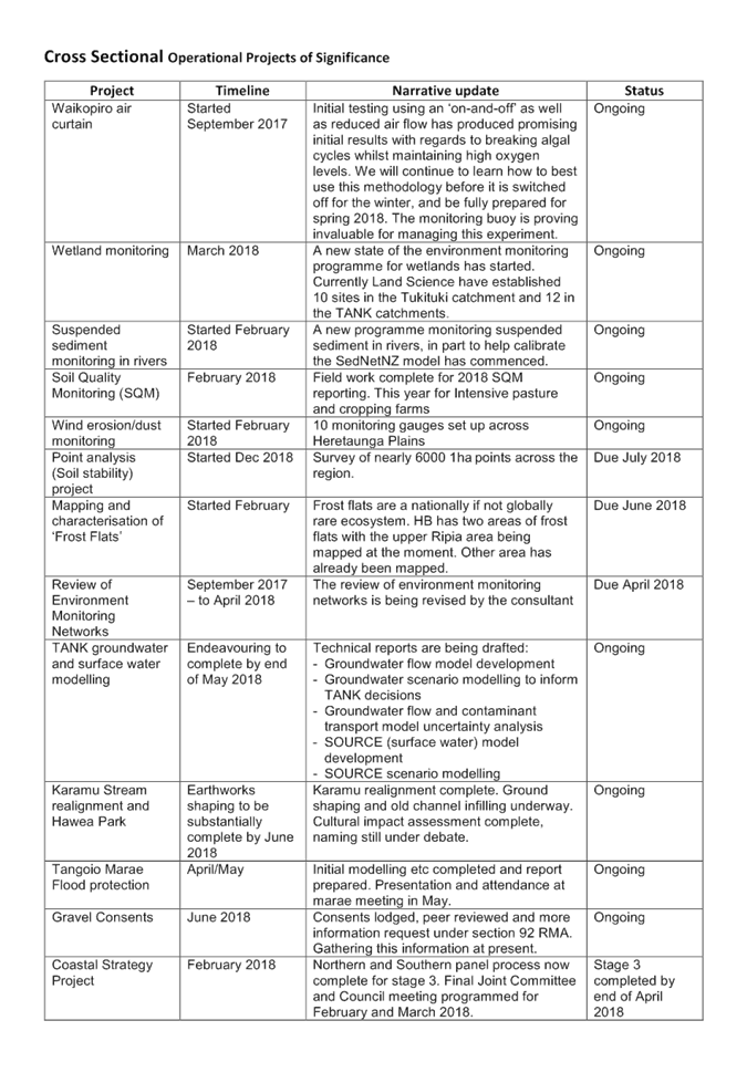
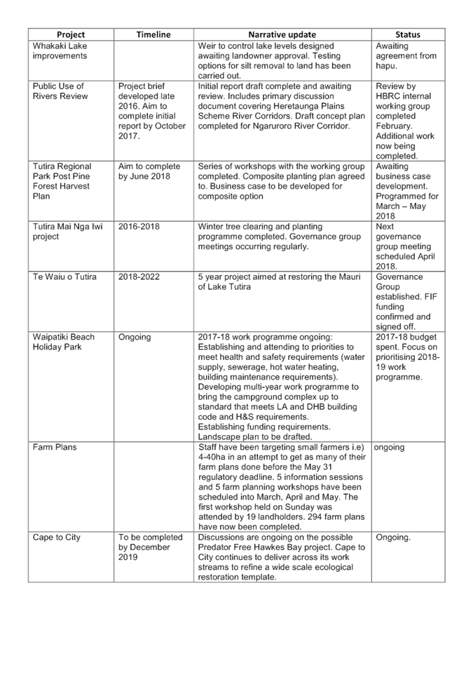
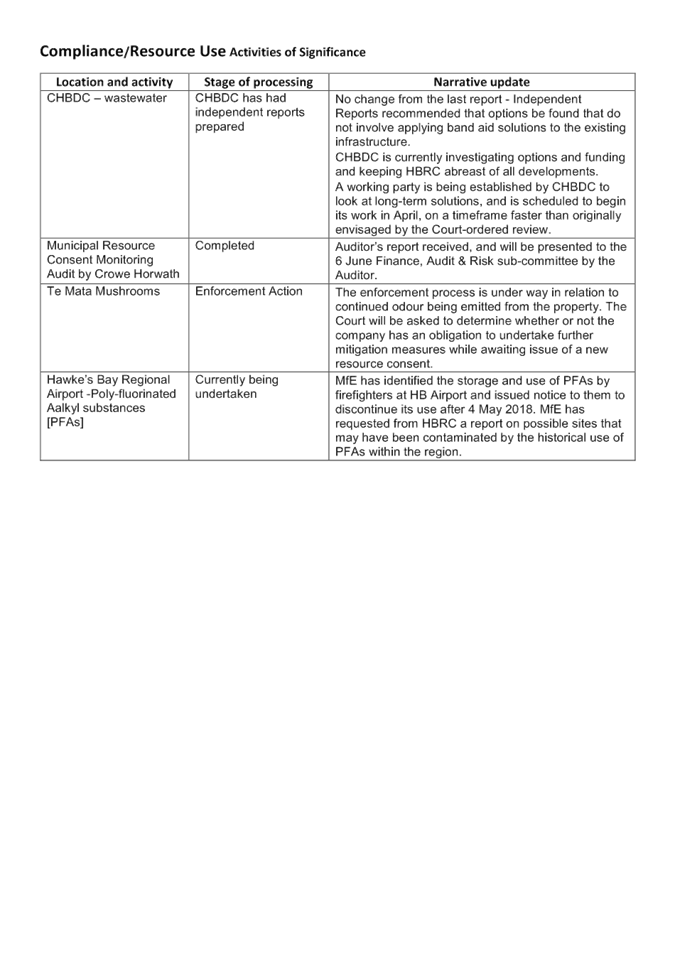
|
Operational
Update for 11 April 2018
|
Attachment 1
|
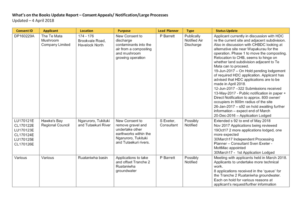
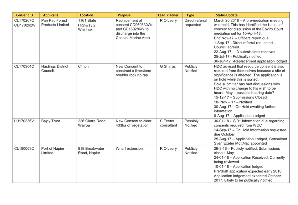
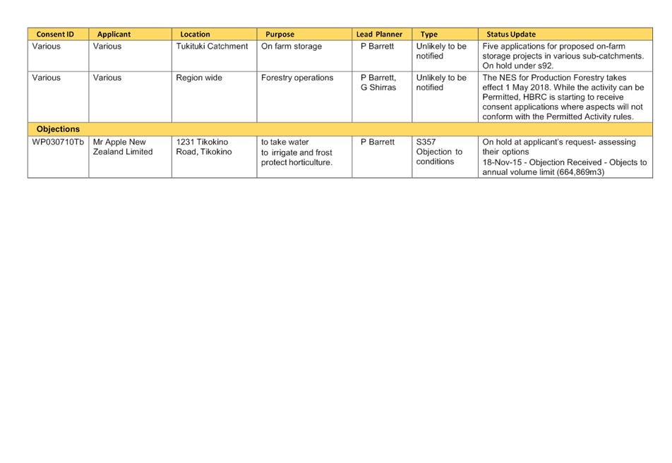
HAWKE’S BAY REGIONAL
COUNCIL
Environment
and Services Committee
Wednesday 11 April 2018
Subject: Discussion of Items Not
on the Agenda
Reason for Report
1. This document has been prepared to assist
Committee Members to note the Items of Business Not on
the Agenda to be discussed as determined earlier in Agenda
Item 5.
1.1. Urgent items of Business (supported by tabled CE or Chairman’s report)
|
|
Item
Name
|
Reason not on Agenda
|
Reason discussion cannot be delayed
|
|
1.
|
|
|
|
|
2.
|
|
|
|
1.2. Minor items (for discussion only)
|
Item
|
Topic
|
Councillor
/ Staff
|
|
1.
|
|
|
|
2.
|
|
|
|
3.
|
|
|