Hawke’s Bay Regional
Council
13
February 2025
Subject:
North Island Weather Events (NIWE) Wairoa Flood Mitigation
Reason for report
1. This item provides the
Council with:
1.1. an overview of the NIWE
funded Wairoa Flood Mitigation project progress to date
1.2. an update on the engagement
with mana whenua, key stakeholders and the community
1.3. the position of the Crown
Manager and Tripartite Partners – Wairoa District Council (WDC) and
Tātau Tātau o te Wairoa Trust (TToTW) – on a preferred option
for flood mitigation for the area of Wairoa with the land categorisation of 2C.
2. The information above is
provided to enable the Council to make the decisions to:
2.1. adopt the preferred option
for flood mitigation for the category 2C area of Wairoa
2.2. approve proceeding with a
Project Delivery Plan submission to Crown for approval and granting of the $70m
funding reserved for the Wairoa Flood Protection Scheme
2.3. Identify critical next
steps for the project, particularly in regard to working with landowners.
3. The critical next steps for
the project, particularly in regard to working with impacted landowners, are
identified within this report.
4. Given the project’s
scale and its potential to significantly enhance the safety and resilience of
Wairoa community, this decision is of paramount importance to both the local
community and the broader region.
Staff
recommendations
5. Staff recommend that
councillors consider the information presented in this agenda item, North
Island Weather Events (NIWE) – Wairoa Flood Mitigation, to inform the
Council decisions necessary for the project to proceed.
6. Further, staff recommend
that Council adopts Option 1C as the preferred option for flood mitigation
works for the area of the Wairoa township in category 2C, to enable the
submission of a Project Development Plan to the Crown and the next stages of
landowner engagement to begin.
7. The Council is also asked
to acknowledge that the preferred option will only proceed upon completion of:
7.1. The satisfactory findings
of an independent review of Option 1C by the Crown.
7.2. The completion and approval
of a Project Delivery Plan that satisfies the requirements of the Crown and
relevant Ministers.
7.3. Land access being secured
in accordance with the Public Works Act 1981 to enable delivery of the
preferred option.
7.4. Positive outcomes from
working with the Māori Land Court and Te Tumu Paeroa over the next 3 to 4
months to secure access to whenua Māori blocks in accordance with Te Ture
Whenua Maori Act 1993.
7.5. The final design of Option
1C may require modifications to the preliminary designs.
7.6. In discussion with the
Crown and Crown Manager, staff will pause design work on Option 1C, over the
period to secure land access.
8. Staff will report to
Council on the progress of key project milestones.
Executive
summary
9. We refer you to the Hawke’s
Bay Regional Council’s Land Categorisation Process and Framework
following Cyclone Gabrielle dated 11 September 2023 report which outlines
how HBRC applied the Government’s Future of Severely Affected Land Risk
Categorisation Framework following Cyclone Gabrielle. It details the process
and technical framework used to assess the risk to affected residential properties
in the Hawke’s Bay region, primarily impacted by flooding during the
cyclone. The report also discusses the funding outcomes negotiated with the
Government to support recovery and flood resilience efforts.
10. On 2 August 2023, HBRC
accepted the Government’s offer of $203.5 million towards flood
mitigation and approved an additional $44.15 million of debt to fund its
cost-share portion. The combined funding is based on community interventions to
move properties out of Category 2 to Category 1, thus limited the number of
properties that might otherwise become Category 3.
11. Of this, the Wairoa Flood
Mitigation project was allocated $70 million, which is 100% Crown funded, with
Council taking the funding risk for actual project costs exceeding the
Crown‘s capped contribution.
12. The main purpose of the
funding allocation is to mitigate flood risk for Category 2C residential
properties, however, noting that 626 (residential, commercial, industrial and
rural) properties in North Clyde and Frasertown areas of Wairoa will receive the
benefit of the flood infrastructure. A further breakdown of the 626 properties
are 380 residential properties with dwellings and 120 residential properties
with no dwelling, with the remaining being either commercial, industrial or
rural.
13. Following an eighteen month
process to identify flood mitigation options a single option, known as Option
1C, has been identified as preferred and is recommended to Council.
14. Option 1C has been
recommended to HBRC by the Crown Manager (Attachment 2) and Wairoa
District Council (Attachment 3) via their support at the Tripartite
Partners meeting dated 5 February 2025.
15. The Board of Tātau
Tātau o te Wairoa has advised that for reasons of tikanga, principally
that landowners need to speak for themselves about their whenua, and that it
does not support an option at this stage but will continue to support Māori
landowners through this process.
16. In the spirit of the
partnership approach to the Tripartite Group, Wairoa District Council and Tātau Tātau o te Wairoa Trust, will speak to
their positions at the 13 February 2025 Council meeting. The Crown Manager will
also speak to his position at this meeting.
Background
17. Cyclone
Gabrielle had a significant impact across the Hawke’s Bay region, with
the Wairoa town and wider district being one of the areas most impacted. The
Wairoa River channel overtopped and began flooding or inundating the area
around North Clyde on the morning of 14 February 2023.
18. Most of North
Clyde was inundated by between 0.5m- 1.5m flood waters which drove the
displacement of people from their homes and businesses and caused widespread
damage.
19. On
1 May 2023 the government announced its land categorisation framework in
response to Cyclone Gabrielle and Auckland Anniversary floods
20. In
June 2023, the initial land categorisation decision was made for Wairoa with
areas in Frasertown being categorised as Category 2P and North Clyde being
categorised as Category 2A.
21. In
July 2023, the Category 2P areas of Frasertown were re-categorised to Category
2A. Wairoa was assigned a Category 2A status to permit a full range of
mitigation approaches to be explored.
22. On 11 April 2024, Wairoa
was re-categorised from Category 2A to 2C, meaning that there were confirmed viable Category 2C solutions for Wairoa.
23. Subject
to confirmation of this pathway, Category 2Cs will be released to Category 1
only when the following conditions are met:
23.1. sound
concept that has a consenting pathway and
23.2. legal
interest in favour of HBRC in the relevant land and
23.3. available
funding.
24. A
stakeholder group was formed in October 2023 and worked through the
identification of 18 potential options for flood mitigation. This was
eventually shortlisted to 2 options, 1C and 1D as being the most technically
viable ones.
25. On
14 August 2024, the appointment of a Crown Manager, Mr. Lawrence Yule, to
Hawke’s Bay Regional Council and Wairoa District Councils was made by the
Minister for Local Government.
26. The
role of the Crown Manager is to direct the Council(s) to address any barriers
to effective flood management of the Wairoa catchment. This includes
facilitating the production of a medium-term flood management plan, actions
arising from the reviews of the June 2024 severe weather event and relationship
management regarding decisions on flood management.
27. The
Council is required, under section 258D(6) of the Act, to: co-operate with the
Crown Manager so that the Crown Manager may fulfil these Terms of Reference,
under which he was appointed; comply with the directions of the Crown Manager;
and comply with any reasonable request of the Crown Manager to provide relevant
information.
28. On
6 September 2024, using his powers under section 258D of the Local Government
Act, the Crown Manager directed the separation of the delivery of the
communications and engagement activity from Hawke’s Bay Regional Council,
and he appointed a communications and engagement lead and advisor who reports
directly to the Crown Manager.
29. Project
workshops to support decision making, were held and led by the Crown Manager
with Wairoa District Council and Tātau Tātau o te Wairoa board on the
28 January 2025 and with Hawkes Bay Regional Council on the 29 January 2025.
30. A
workshop and decision meeting were held with the Tripartite partners on 5
February 2025. The workshops listed above were the culmination of a long series
of engagements to test and refine the options.
Order in Council background
31. The
Government has made a short-term law change to the Resource Management Act 1991
(RMA) and associated regulations, and plans through the Severe Weather
Emergency Recovery Legislation Act 2023 (SWERLA) to speed up flood protection
works in Hawke’s Bay.
32. The
Hawke’s Bay Regional Recovery Agency (HBRRA) developed the Hawke’s
Bay Regional Recovery Plan, which set out the outcomes, priorities, actions and
funding needed for the region’s recovery. The recovery plan identified
flood protection works and mitigation, achieved through an Order in Council
(OiC), as a key action for the region’s recovery.
33. The
flood protection works require resource consents under the Resource Management
Act 1991 (RMA). Due to the complexity of these consents, a public notification
process would usually be required. This process can take up to 9 months for a
decision to be issued by the consent authority, with potentially a further 12
months or more is required if the decision is appealed to the Environment
Court.
34. The
OiC will help consent applicants to avoid these delays and give them greater
certainty, including conditions which ensure engagement occurs.
35. The
project works covered by this OiC include:
35.1. the
construction of stop-banks, culverts, retaining walls, bridge works, pump
stations, stream alignments and earthworks
35.2. activities
that are concerned with the construction or reinstatement of, making safety
enhancements to, or improving the resilience of land and flood protection
infrastructure.
36. The
OiC does not allow an existing consent to be varied. If a consent holder wants
to change or cancel the conditions of an existing resource consent, they will
need to use the standard s.127 RMA process.
37. The
OiC will ensure that people and communities in Hawke’s Bay can better
recover from the effects of Cyclone Gabrielle and are protected against future
events.
Category 2C Areas in Wairoa
38. The total property numbers
in the Category 2C Areas can be summarised as follows:
38.1. Number of properties = 626
(380 residential with dwellings, 120 residential with no dwelling, remaining
commercial, industrial and rural)
38.2. Number of residential
properties = 500 (approximately)
38.3. Number of residential
properties with dwellings = 380
38.4. Number of residential
properties with no dwelling = 120
38.5. Number of properties with
$0 improvement value = 140
38.6. Total Land Value =
$65,638,400
38.7. Total Capital Value =
$188,345,300
38.8. Total Improvement Value =
$122,706,900.
39. The
current Category
2C areas are in Frasertown and North Clyde, as follows.
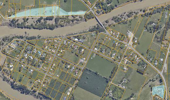
Category
2C area in Frasertown
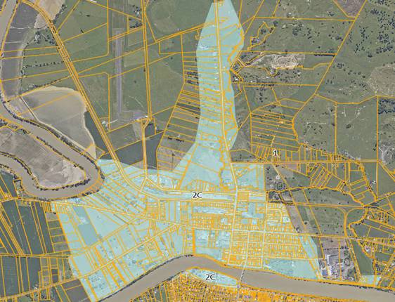
Category
2C area in North Clyde
Options assessment
40. A Stakeholder Group was
formed in October 2023 with one of their tasks being to consider and provide
feedback to the Wairoa Flood Mitigation Project Team on the various options for
flood mitigations in Wairoa.
41. Membership to the
Stakeholder Group was voluntary, with membership invited and appointed from the
following:
41.1. Wairoa District Council
– 2 members
41.2. Tātau Tātau o te
Wairoa Trust – 2 members
41.3. Hawke’s Bay Regional
Council – 2 members
41.4. Community members – 2
members
41.5. Local farming community
– 2 members
41.6. Local business community
– 2 members
41.7. One representative each
from Takitimu and Tawhiti-a-Maru Marae.
42. Eighteen long-list options
were identified and then considered and assessed via a multi- criteria analysis
led by Council’s contracted engineering service providers.
43. Of these options, 6 were
recommended from the long list, plus 4 additional floodway options or
combinations.
44. This has included seeking
input from subject matter experts and a peer review of short-listed options.
45. At the 15 August 2024
Stakeholder Group Meeting, the members considered the shortlist options, with
support from technical experts, resulting in their support for the 2 options of
Option 1C and a refined version of Option 1D where secondary inundation impacts
are minimised. It was agreed that these be forwarded to the Tripartite partners
for their consideration.
46. From November 2024, the
community of Wairoa was provided with a project brochure (Attachment 1) and presentations held at
several public meetings which outlined the process to date, the 18 options,
their benefits and limitations.
Option
1C and 1D analysis detail
47. A review of Options 1C and
1D has been undertaken across the 6 key criteria as follows:
47.1. Cost comparison
47.2. Constructability
47.3. Effectiveness
47.4. Overdesign and Climate
Change
47.5. Cultural impacts
47.6. Consenting.
48. Note: this analysis is as
at the time of this report being written. Staff continue fine tuning estimated
costs, designs and other project components.
49. It is also important to
note that the Ski Club stop bank/protective structures will be required for
both options and have been incorporated in the 6 key criteria.
50. The 6 assessed criteria can
be summarised as:
Cost
comparison
50.1. Option 1C – has a total project cost
estimate of $69.7m inclusive of contingencies of 35% for construction and 25%
for Land Access
50.2. Option 1D – has a total
project cost estimate of $65.9m inclusive of contingencies of 35% for
construction and 25% for Land Access
50.3. Analysis -Based on the total
project budget 1 D has the lowest overall cost but there is only a marginal
difference between the 2 options, and both are presently within the project
budget of $70m.
Constructability
50.4. Option 1C- Geotechnical investigations
and material testing has been conducted across the footprint and has been used
to assess the availability of suitable material, ground conditions including
water table depth. Based on these reports there is sufficient suitable material
for this option. Due to the depth of excavation and high-water table,
additional time and cost is required. A cost-effective method has been found
for the disposal of the surplus cut to waste material.
50.5. Option 1D- Geotechnical investigations
and material testing has been conducted across the footprint and has been used
to assess the availability of suitable material, ground conditions including
water table depth. Based on these reports there is sufficient suitable material
for this option. Due to the lower depth of excavation, the high-water table has
no significant effect.
50.6. Analysis- Based on the availability
and suitability of material, no requirement to dewater the site to the extent
of Option 1C and the reduced depth of excavation 1D has the better
constructability.
Effectiveness
50.7. When considering the effectiveness
of the option, the assessment considers the impacts of a 1 in 100 year event on
not only the area that receives the benefit of the flood infrastructure but the
remaining surrounding area.
50.8. Option 1C – This option will result in 10ha of land negatively (worse
off) affected by flooding compared to doing nothing, 513ha of land positively
affected (better off) by flooding compared to doing nothing. It is noted that the
spillway in Option 1C is the closest to the natural course the river is taking
in flooding events.
50.9. Option 1D- This option will result in
296ha of land negatively (worse off) affected by flooding compared to doing
nothing, 350ha of land positively affected (better off) by flooding compared to
doing nothing.
50.10. Analysis- Both options provide the
required benefit in reduced flooding to the land Category 2C area in North
Clyde, however Option 1C provides the most benefit with the minimal amount of
negatively affected land and increased positively affected land. Option 1C is
the option that is the closest to pathway that the river naturally wants to
follow in a major flood situation.
Overdesign
and Climate Change
50.11. Cyclone Gabrielle was assessed as a 1
in 70 year flood event in Wairoa, while other areas in Hawke’s Bay
experienced much more significant events. When modelling the options, we have
allowed for a larger event than what occurred during Cyclone Gabrielle, being a
1 in 100 year (current climate, base on post cyclone)
50.12. Option 1C
– This option, in a 1% AEP +12% climate change river flow situation will
result in a building flood hazard increase of 2 buildings in North Clyde and 27
in Wairoa. Whereas the number of buildings where the flood hazard has decreased
is 520 in North Clyde and 22 in Wairoa.
50.13. Option 1D – This option, in a 1% AEP
+12% climate change river flow situation will result in a building flood
hazard increase of 26 buildings in North Clyde and 488 in Wairoa. Whereas as
the number of buildings where the flood hazard has decreased is 540 in North
Clyde and 24 in Wairoa.
50.14. Analysis – In a 12% over
design event there is significant negative results for property on the town
side in Option 1D compared to Option 1C. In a 20% and 25% over design scenario
both options perform similarly to having no flood mitigation scheme in place.
Cultural
impacts
50.15. Option 1C- Cultural Impact
Assessment (CIA) highlights the impacts of excavation and building work at or
near the site of Pā Koutu (Kautu), work occurring around the residence of
Te Kautu and the exit of the spillway occurring in the same area and work in close
vicinity to Tawhiti a Maru Marae.
50.16. Option 1D - CIA highlights impacts of
the spillway travelling by the Makeakea Urupā, the spillway travels
over the possible site of an old whare which if unearthed would hold
significant cultural significance, intersects the path travelled by kohu
(mist) as described above between Makeakea urupā and Waihirere urupā,
the floodway encompasses a tī kōuka (as described above) that holds
significance and the spillway exit encompasses the anchorage / repair site for
Takitimu.
50.17. Analysis- Based on the details of the
CIA and the number of recommendations and how these can be accommodated in the
project, Option 1C has the lowest cultural impact with the fewer overall
recommendations that can be incorporated into final designs.
Consenting
50.18. Option 1C- The current Order in
Council (OIC) allows for most of the area required for this option. An
-application to increase the boundary may be required if the boundaries of the
spillway cannot be adjusted to fall within the OIC area.
50.19. Option 1D- The current Order in
Council (OIC) does not cover most of the area of this option. An application to
include the project area in the OIC will be required and this will likely take
some months.
50.20. Analysis- Both options require a
change to the current OIC project mapped boundary, with Option 1C requiring the
least number of changes.
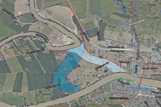 Map- Option 1C and 1D with
town side protection
Map- Option 1C and 1D with
town side protection
Summary
Option 1C solution
51. Excavated 170m wide, 1,100m
long and 2m deep floodway with an average 1.2m high with 4m crest, stopbanks
each side.
52. Stopbank/ flood mitigation
structures on town side from SH2 bridge past the Ski Club and continuing
upstream to higher ground. Total length approximately 1,200m.
53. Will potentially impact 16
houses, 6ha of Māori whenua and 18 ha of general title land.
54. Will protect 46ha of
Māori whenua and 298 ha of general title land
55. Will protect community
assets in Alexandra Park and private properties adjacent to Marine Parade,
Churchill Ave and Mitchell Road.
56. To include the elevation of
2 houses on Pakowhai Road and 1 house on Frasertown Road.
Summary
Option 1D solution
57. Consisting of a 250m wide
floodway and an average 0.9m depth. The stopbanks will average 2.3m high with a
4m crest, each side.
58. Stopbank/ flood mitigation
structures on town side from SH2 bridge past the Ski Club and continuing
upstream to higher ground. Total length approximately 1,200m
59. Will potentially impact 6
houses, 18.4ha of Māori whenua and 26.6 ha of general title land.
60. Will protect 30ha of
Māori whenua and 248 ha of general title land
61. Will protect community
assets in Alexandra Park and private properties adjacent to Marine Parade,
Churchill Ave and Mitchell Road.
62. To include the elevation of
2 houses on Pakowhai Road and 1 house on Frasertown Road.
Strategic
fit
63. The Wairoa Flood Mitigation
project aligns with the Strategic Plan 2020-2025 Outcomes, Goals, and Actions
(pages 12-15). This project contributes towards achieving the strategic goal of
sustainable and climate-resilient services and infrastructure, through
increasing flood protection levels to provide practical and affordable
protection to our communities.
64. This project contributes to
Council’s community outcomes of
64.1. Resilient Community- Our communities are
prepared for natural hazards, supported by planning and infrastructure,
partnerships and knowledge sharing on the increasing effects of climate change.
64.2. Prosperous Community- Our communities thrive from
high-performing regional infrastructure that enables the region's natural and
human resources to deliver goods and services that underpin prosperity and
wellbeing.
65. In addition to the
Strategic Plan 2020-2025 this project contributes towards achieving a resilient
and prosperous community as part of the Infrastructure Strategy in our
Three-Year Plan 2024-2027.
Significance
and Engagement Policy assessment
66. The Wairoa Flood Mitigation
project holds a high level of significance as it directly impacts the safety,
well-being, and economic stability of the Wairoa region. According to
Council’s Significance and Engagement Policy (SEP) contained in the
Long-Term Plan (pg. 208), the significance of this project is assessed as high.
67. This high level of
significance necessitates extensive community engagement to ensure that the
views and concerns of all stakeholders are adequately considered.
68. The project has involved extensive
engagement and collaboration with various community groups, including the
Stakeholder Group, which provides a platform for representative views from
different sections of the community.
69. The Crown Manager’s
team has made substantial progress in this area with the full knowledge,
support and agreement of Council. However, there is still engagement required
to ensure full compliance with our policy and other statutory obligations, including
those under the Local Government Act 2002 (LGA), Public Works Act 1981 (PWA),
Te Ture Whenua Māori Act 1993 and the Order in Council (OiC), specifically
in relation to land access and satisfy the conditions of the OiC.
Considerations
of and engagement with tangata whenua interests
70. The Wairoa Flood Mitigation
Project has been approached with a view to working with the cultural, social,
and economic interests of mana whenua and tangata whenua, ensuring that any
infrastructure delivered with the principles of Te Tiriti o Waitangi prioritised.
This section outlines the key considerations, legislative context, and
mitigation measures adopted to support an approach that is consistent with Te
Tiriti o Waitangi.
71. The Public Works Act (PWA)
provides the statutory framework for land access for the implementation of
public infrastructure projects. While the PWA does give certain rights to
Council, similarly it provides protection to landowners to ensure they are treated
fairly, consistently and placed in a ‘no better no worse’ situation
than they presently enjoy. However historically, the application of the PWA has
often resulted in the displacement of Māori communities and a weakening of
their connection to ancestral lands, particularly in Wairoa. This challenging
and painful history is acknowledged by Council.
72. When considering access to
whenua Māori, Te Ture Whenua Māori Act 1991 (TTWMA) is also relevant.
One of the principal purposes of TTWMA is to promote the retention of land in
Māori ownership. The Māori Land Court is already engaged in this
project and an order of the Court will be required granting access to each
Māori Freehold land parcel that is impacted by the project.
73. In response, the project
has been developed to ensure compliance with statutory requirements with a
focus on safeguarding the cultural heritage of mana whenua and tangata whenua.
We are also working with the Māori Land Court to explore an approach to
land access for impacted whenua Māori which ensures retention of land in
Māori ownership and continued rights of access for Māori after
completion of the project.
74. Further a thorough review
of significant cultural sites has been integrated into the project design. This
process has identified key cultural sites and practices that are integral to
the community’s heritage. The design incorporates measures to avoid or
protect these sites, thereby ensuring that the cultural values attached to the
land are maintained. Such measures include clearly defined buffer zones and
protection protocols, which are integral to preserving the integrity of
culturally significant areas.
75. Engagement has been
conducted through established project stakeholder and governance groups, which
include representation from local marae, and the wider community. These groups
and individuals have provided essential input on the integration of cultural
site protections and the overall approach to land access.
76. With a preferred option
selected, a period of focussed engagement with mana whenua and impacted
Māori landowners can commence. This will be the primary focus for the
project team over the next 3 to 4 months with the Māori Land Court and Te
Tumu Paeroa involved to support and oversee this engagement process. A judicial
conference will be set by the Court later this month.
Financial
and resource implications
77. Under the Crown Funding
Agreement for the NIWE projects, signed October 2023, the Wairoa Category 2
Flood Mitigation Project was estimated at $70m. This is fully funded by the
Crown, with any project overruns to be met by Council.
78. The costs for Option 1C and
1D have been built up from various sources with the most critical being:
78.1. Construction estimates are
Quantity Survey estimates based on concept designs
78.2. Land Access costs have been
established by property experts from desk top information
78.3. Professional fees and IPMO
costs are based on actuals to date plus costs estimated to the project
completion
79. The cost estimates
critically include the following contingencies:
79.1. Construction costs 35%
79.2. Land Access 25%
80. Current cost estimates are:
80.1. Option 1C - $69.7m
including a $16.5m project contingency
80.2. Option 1D - $65.9m
including a $15.5m project contingency.
81. The cost estimates contain
appropriate contingencies, as these are necessary at this early stage of the
project lifecycle. Despite these contingencies, a robust approach to cost
management throughout the term of the project will be critical to ensure the
costs fall within the Crown funding limit and if possible, the project is
completed within the budget. This will then create the possibility of further
flood mitigation works being completed for the Wairoa township.
Community
and stakeholder engagement
82. The Tripartite partners
– Wairoa District Council, Tātau Tātau o te Wairoa Trust and
Hawke’s Bay Regional Council, together with the Crown Manager have been
working together on communication and engagement initiatives to support the
project.
83. Early in the project, these
initiatives largely involved the Wairoa Flood Mitigation Project Stakeholder
Group, mana whenua, river engineers and other technical experts, as the project
worked to progress to a point of having technically viable options to take to
the community.
84. More recently, following
the Tripartite partners’ endorsement of the project’s overarching
C&E Strategy, this engagement activity has extended out to include
potentially impacted whānau, home and landowners as well as the broader Wairoa
community.
85. Direct engagement with those home
and landowners potentially impacted by Options 1C and 1D commenced from
mid-October and has remained a priority area of focus for the project team. In
many cases this, one-to-one engagement has continued on a regular basis at the
request of individual owners.
86. Additionally, both the
Māori Land Court and Te Tumu Paeroa are already engaged, and a judicial
conference will likely be held later this month. Any decisions relating to
whenua Māori will need to be approved by the Māori Land Court which means
that decisions of the Court will be critical in progressing this project.
87. At this stage in the
project, the sentiment of specific home and landowners regarding Options 1C and
1D remains varied. There are owners in both Options who have indicated they are
fully supportive and prepared and ready to relocate – equally, there are
owners in both Options who have indicated a preference to remain in their home
or on their land.
88. Ongoing conversations with
owners regarding their individual circumstances, preferences and aspirations
have occurred and, where possible, refinements or adjustments to either option
have been discussed.
89. Additionally, at the most
recent Tripartite recommendation hui of 5 February 2025, it was agreed that an
intensive, three-month period of sustained focus specifically on direct
engagement with impacted land owners of bare land, including owners of whenua
Māori, would remain the focus.
90. A dedicated project website
(https://www.wairoafloodproject.co.nz/) has been developed with information,
reports and updated news being loaded regularly. This site also has contact
details for the project team.
91. The following table
summarises the key engagement milestones described in that Communications
Strategy and the achievements to date.
|
Date
|
Activity
|
|
June
2023
|
HBRC
Comms and Engagement commences
|
|
June
|
Community
based feedback sessions
|
|
2
October 2024
|
Tripartite
partners endorsement of C&E Strategy
|
|
14
October
|
Early
engagement direct w potentially impacted owners
|
|
30
October
|
Dedicated
project website live
|
|
30
October
|
First
wānanga for potentially impacted whānau
|
|
5
November
|
First
community hui
|
|
5
November
|
First
proactive media release
|
|
26
November
|
Second
wānanga for potentially impacted whānau, home and landowners, and
North Clyde 2C residents
|
|
2
December
|
Second
community hui
|
|
3
December
|
Cultural
and ‘lived experience’ hui with Tātau Tātau o te Wairoa
Trust Hinemihi Marae
|
|
11
December
|
Second
proactive media release
|
|
21
January 2025
|
Drop-in
engineers session / site visit to Wairoa A&P Showgrounds
|
|
21
January
|
Third
wānanga for potentially impacted whānau, home and landowners, and
North Clyde 2C residents
|
|
27
January
|
Information
evening for potentially impacted owners on Wairoa town side of the river
|
|
5
February
|
Project
update following the Tripartite recommendation hui, proactively communicated
to potentially impacted home and landowners
|
|
Ongoing
|
Direct
engagement with potentially impacted owners, as requested.
|
Key milestones moving forward
92. The following table
summarises the key milestones that are programmed over the next 5 months.
|
Date
|
Activity
|
|
10
February
|
Crown
review of preferred option commences
|
|
13-
28 February
|
Finalise
Draft Project Delivery Plan
|
|
13
February
|
Fourth
wānanga for impacted whānau, home and landowners in the preferred
option area.
|
|
21
February
|
Kopu
Road and Ngamotu Option Concept Drawing, Cost
estimates, visualisations completed
|
|
6
March
|
Tripartite
Hui- Kōpu Road, bar consideration
|
|
7
March
|
Final
PDP completed and submitted to National Infrastructure Funding and Finance
(NIFF)
|
|
10-20
March
|
Treasury
reviews, NIFF approvals, submission to Central Government Ministers
|
|
31
March
|
Target
for Minister approved Project Delivery Plan
|
|
February
|
Property
Specialists and others will be engaged to work with impacted owners on behalf
of Council
|
|
February
- June
|
Focus
on seeking to better understand land accessibility, working closely with
Māori Land Court and Māori Trustee, through Te Tumu Paeroa, to
support whenua Māori owners through the process.
|
|
As
key milestones occur
|
Updated
project reports to Council
|
Project risks
93. Projects of this complexity
and cost all come with a degree of risk, which need to be identified,
mitigated, monitored and reported on. The following are the higher risks and
summarised mitigation methods in place.
94. Land access –
Dedicated land access team, Clear compensation framework in place, Transparent,
professional and targeted communication, Outstanding relationship management
with landowners, Engagement of appropriate, people-focused, capable property services
advisors.
95. Scope creep – All
potential scope and design changes to go through control group process,
High-value and significant design changes require senior leadership/ Council
sign-off, Robust communication with all key stakeholders.
96. Extended schedule –
Regular schedule reviews and updates, Identification of early work
opportunities, with a view to accelerating work wherever possible.
97. Unknown presence of
contaminated land and buildings – Engagement of suitable testing
contractor, Early and comprehensive testing of sites and buildings.
98. Reputation lost and/or
relationship damage – Media & Public – Robust relationship
management, Crown Manager overseeing all comms and engagement and is working in
partnership with HBRC, WDC, TToTW. Regular community and stakeholder updates, A
no surprises approach.
99. Underperforming contractors
– Thorough vetting during procurement process, Proactive monitoring and
evaluation, Robust contract documentation, Early problem identification and
rapid resolution processes initiated.
100. Disturbance resulting from
construction activities – Employ best practice construction and
mitigation methods (e.g. dust suppression), Proactive engagement with affected
parties throughout construction, Rapid response to any complaints.
Other considerations
101. The Crown Manager is recommending to
Council that it proceed, with Option 1C and develop a Project Delivery Plan,
submit it to the Crown for approval and the granting of the $70m funding
reserved for the Wairoa Flood Protection Scheme. His Option 1C recommendation
is based on the following:
101.1. It is the most direct overland path
closest to where the river has gone in previous flood events. It is the best
hydraulic solution of the two options.
101.2. A solution has been found to the 1C
water table and cut-to-waste issue, and fill may have a beneficial use
elsewhere including Kopu Road.
101.3. Due to a cut to waste solution, 1C can
now be undertaken within the $70m funding.
101.4. Option 1C has significantly less
upstream impacts.
101.5. While it impacts 10 more homes than
1D, up to 10 homes will have to be lifted in 1D to avoid secondary effects.
101.6. Option 1C has a smaller land footprint
including significantly less Whenua Māori land.
101.7. It impacts 12 parcels of Whenua
Māori Land compared with 29 in 1D and avoids significant cultural sites
around Makeke Urupa.
101.8. Both 1C and 1D will have land access
challenges and current knowledge means this is not a consideration in his
recommendation.
102. The Crown Manager also wishes to
inform Council that he intends, with Council support and participation, to
spend the next 3 months focusing on seeking to better understand land
accessibility and this may result in some movement in the exact footprint. Land
access remains the key unquantified risk to the project.
103. Council is currently undertaking
additional work to identify options for the flood mitigation of the Kopu Road
and Ngamotu Road and the management of the Wairoa River Bar. Significant work
is in progress in the upper catchment to manage erosion and sediment loss.
Currently a stocktake on this is underway.
Decision-making considerations
104. Council and its committees are
required to make every decision in accordance with the requirements of the
Local Government Act 2002 (the Act). Staff have assessed the requirements in
relation to this item and have concluded:
104.1. The decision does not relate to a
strategic asset, as listed in the Council’s Significance and Engagement
Policy.
104.2. The decision will involve the
commencement of a new significant activity, being flood protection works for
Wairoa. This type of decision needs to be provided for in the Council’s
Long-Term Plan (LTP), and for that reason – while the Council had not yet
determined its preferred option – it included provision for this project,
and others, in the 3-year LTP 2024-2027. As a result, this decision is
not inconsistent with any existing Council policy or plan.
104.3. The use of the special consultative
procedure is not required in this situation, as provision for the decision has
been included in the existing LTP.
104.4. The decision is significant under the
criteria contained in Council’s adopted Significance and Engagement
Policy.
104.5. The persons affected by this decision
are the Wairoa residents, mana whenua, property and business owners, whenua
Māori owners and visitors to Wairoa.
104.6. Given the nature and
significance of the issue to be considered and decided, and reflecting on
the community engagement to date. It can be concluded that Council has
sufficient understanding of the views and preferences of interested
parties/affected persons so that it can make the decision without any further
consultation.
Recommendations
That Hawke’s Bay Regional
Council:
1. Receives and considers the North
Island Weather Events- Wairoa Flood Mitigation staff report.
2. Agrees that given the nature and significance
of the issues to be considered and decided, and reflecting on the community engagement to date,
Council has sufficient understanding of the views and preferences of interested
parties and affected persons to enable it to make the relevant decisions
without consulting further with the community at this time.
3. Notes
that investigation of options for flood mitigation for North Clyde (Category
2C) have been completed to a stage where a preferred option has been
identified.
4. Notes
that work has been guided by the Tripartite Group and the Crown Manager.
5. Adopts
Option 1C as the preferred option for flood mitigation for the Category 2C area
of Wairoa as it provides the best possible mitigation within budget.
6. Directs
the project team to complete a Project Development Plan for submission to the
Crown based on Option 1C.
7. Notes that the next step in
the project, working with the Crown Manager and Tripartite Partners, will be to
engage with impacted landowners in the 1C Option area to determine the
probability of securing land access necessary to allow the project to proceed.
8. Notes that land access will
be secured in accordance with the Public Works Act 1981.
9. Notes that land access over
Māori Freehold land will be secured in accordance the Te Ture Whenua
Māori Act 1993, and that the Māori Land Court and Te Tumu Paeroa are
already engaged in this process.
10. Thanks mana whenua, the
Wairoa community, landowners and homeowners, the Stakeholder Group, the
Tripartite Group and the Crown Manager for their work in reaching this step in
the project.
Authored by:
|
Steve Fabish
Senior Project Manager
|
Jess Bennett
Programme Finance & Controls
Manager
|
|
Andrew Caseley
Manager Regional Projects /
Programme Director IPMO
|
Chris Dolley
Group Manager Asset Management
|
Approved by:
Attachment/s
|
1
|
Information for the Wairoa community
30 October 2024
|
|
Under Separate Cover
online only
|
|
2
|
Crown Manager 10 February 2025
Recommendation to HBRC
|
|
Under Separate Cover
online only
|
|
3
|
Wairoa District Council 10 February
2025 recommendation to HBRC
|
|
Under Separate Cover
online only
|