Meeting of the Environment and Services Committee
Date: Wednesday 11 May 2016
Time: 9.00 am – Powhiri
Formal meeting to commence at 9.25 am
|
Venue:
|
Kohupātiki
Marae
Farndon Road, Clive
|
Agenda
Item Subject Page
1. Welcome/Notices/Apologies
2. Conflict
of Interest Declarations
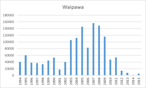
3. Confirmation of
Minutes of the Environment and Services Committee held on 9 March 2016
4. Matters Arising
from Minutes of the Environment and Services Committee held on 9 March 2016
5. Follow-ups from
Previous Environment & Services Committee Meetings 3
6. Call for any Minor
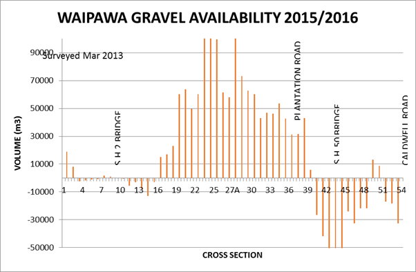
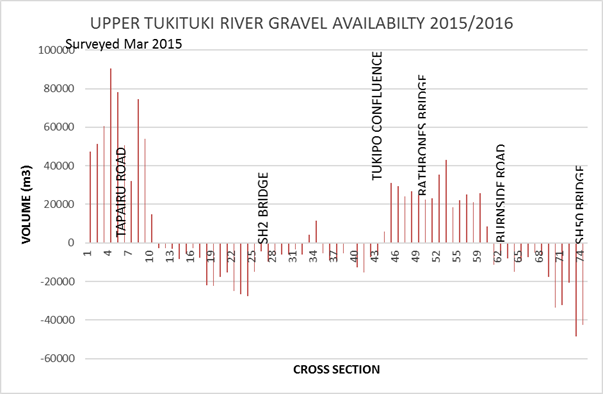
Items Not on the Agenda 15
Decision Items
7. Kohupātiki
Marae - Awa Enhancement for Matatini – 9.30 am 17
8. Te Mata Park 10
Year Management Plan 23
9. Upper Tukituki
Scheme Review 39
10. Tangoio Soil Conservation
Reserve Management Plan 53
11. Biosecurity Operational Plans
for 2016-17 55
Information or Performance Monitoring
12. Cape to City Update 105
13. Land Science Update 111
14. Minor Items Not on the Agenda 113
HAWKE’S BAY REGIONAL COUNCIL
Environment
and Services Committee
Wednesday 11 May 2016
SUBJECT: Follow-ups from Previous Environment
& Services Committee Meetings
Reason for Report
1. Attachment 1 lists items
raised at previous meetings that require follow-ups. All items indicate who is
responsible for each, when it is expected to be completed and a brief status
comment. Once the items have been completed and reported to the Committee they
will be removed from the list.
Decision
Making Process
2. Council is required to make a decision in
accordance with Part 6 Sub-Part 1, of the Local Government Act 2002 (the Act).
Staff have assessed the requirements contained within this section of the Act
in relation to this item and have concluded that as this report is for
information only and no decision is required in terms of the Local Government
Act’s provisions, the decision making procedures set out in the Act do
not apply.
|
Recommendation
1. That the Environment and Services Committee
receives the report Follow-up Items from Previous Environment &
Services Committee Meetings.
|
|
Mike Adye
Group Manager
Asset Management
|
Iain Maxwell
Group Manager
Resource Management
|
Attachment/s
|
1
|
Follow Up
Items from the Previous Environment & Services Committee
|
|
|
|
2
|
296-081 Te
Karamu Enhancement Before & After Photos 1972-2015
|
|
|
|
Follow
Up Items from the Previous Environment & Services Committee
|
Attachment 1
|
Follow-ups from Previous Environment & Services
Committee Meetings
9 March 2016
|
|
Agenda item
|
Follow-up item
|
Person Responsible
|
Status/Comment
|
|
1
|
Follow-ups
|
Gravel
Management Review Timetable Tukituki Gravel Issues
|
M Adye
|
Paper to the
Environment & Services Committee 11 May 2016.
|
|
2
|
Follow-ups
|
A
Land Science Update report covering soil monitoring and molybdenum would be
provided at the next E&S meeting.
|
I Maxwell
|
Paper
to the Environment & Services Committee 11 May 2016.
|
|
3
|
Follow-ups
|
Visit from PCE to talk about Oil & Gas Exploration
regulation
|
L Lambert
|
No
response since last report.
|
|
4
|
Otane Wastewater
Resource Consent Application
|
A
further update requested on the ground water quality at the next meeting.
|
M Miller / I Maxwell
|
The
data relating to this investigation is still not available as the
investigation is ongoing. When this information is available a paper will
come back to the Committee updating on groundwater quality.
|
|
5
|
Lake Tutira Science
Update
|
Circulate
a copy of Dr Hick’s presentation with the draft minutes.
|
M Thomsen
|
Completed,
circulated on 23 March 2016.
|
|
6
|
Lake Tutira Science
Update
|
Present
to the 12 April 2016 Maori Committee meeting.
|
A Hicks / I Maxwell
|
This
item was presented to the Maori Committee on 12 April 2016.
|
|
7
|
Resource Use Update
|
Introduce
the new Harbourmaster to the Committee.
|
W Wright / I Maxwell
|
The
Harbourmaster will attend the next Committee meeting and present his work.
|
|
8
|
Te Karamu Enhancement
Strategy and Operational Plan
|
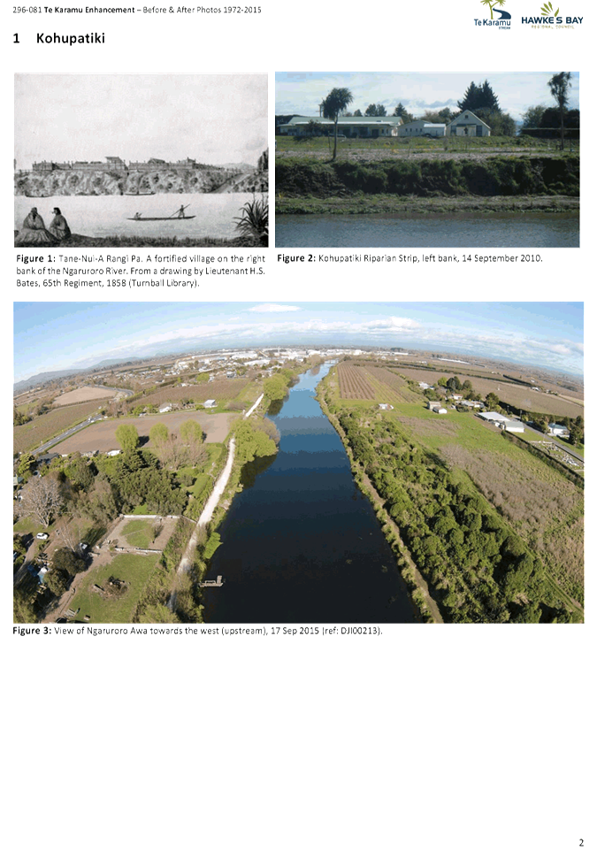
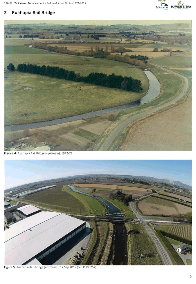
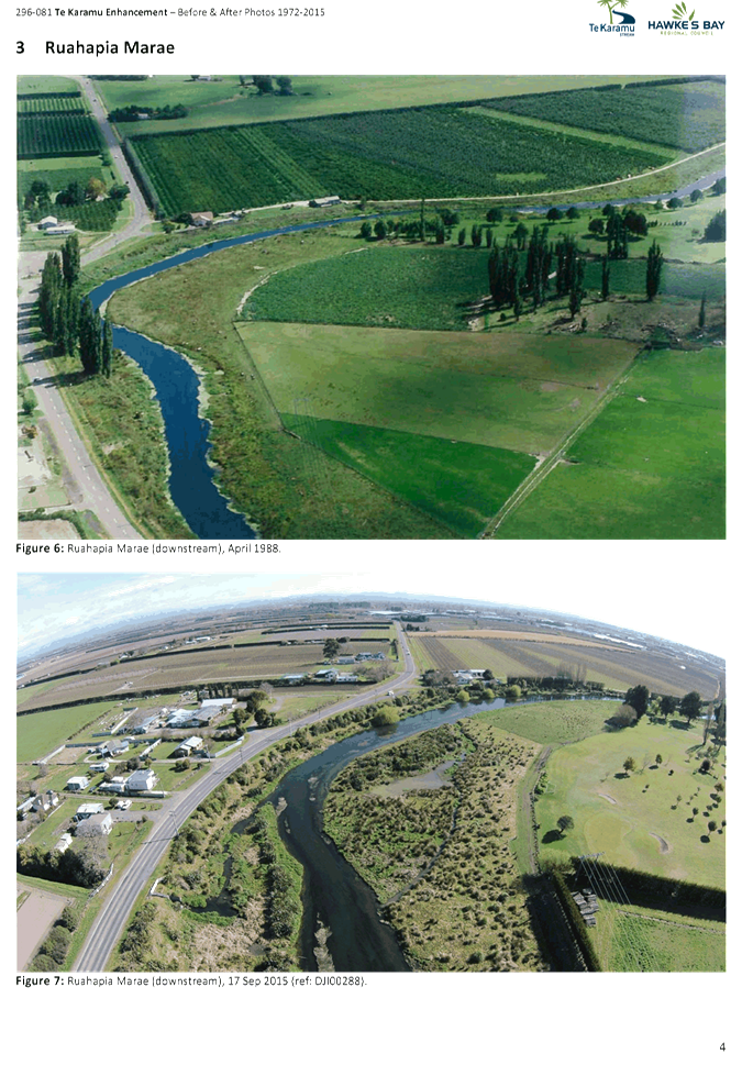
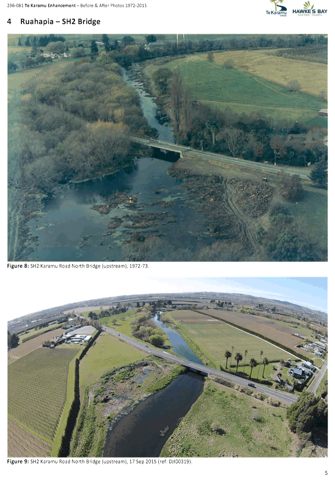
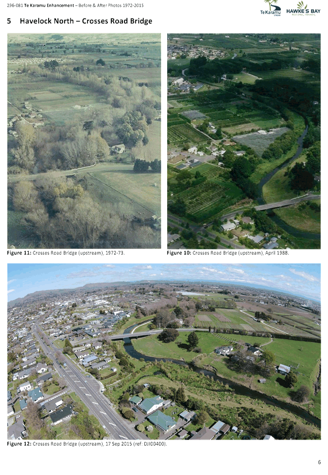
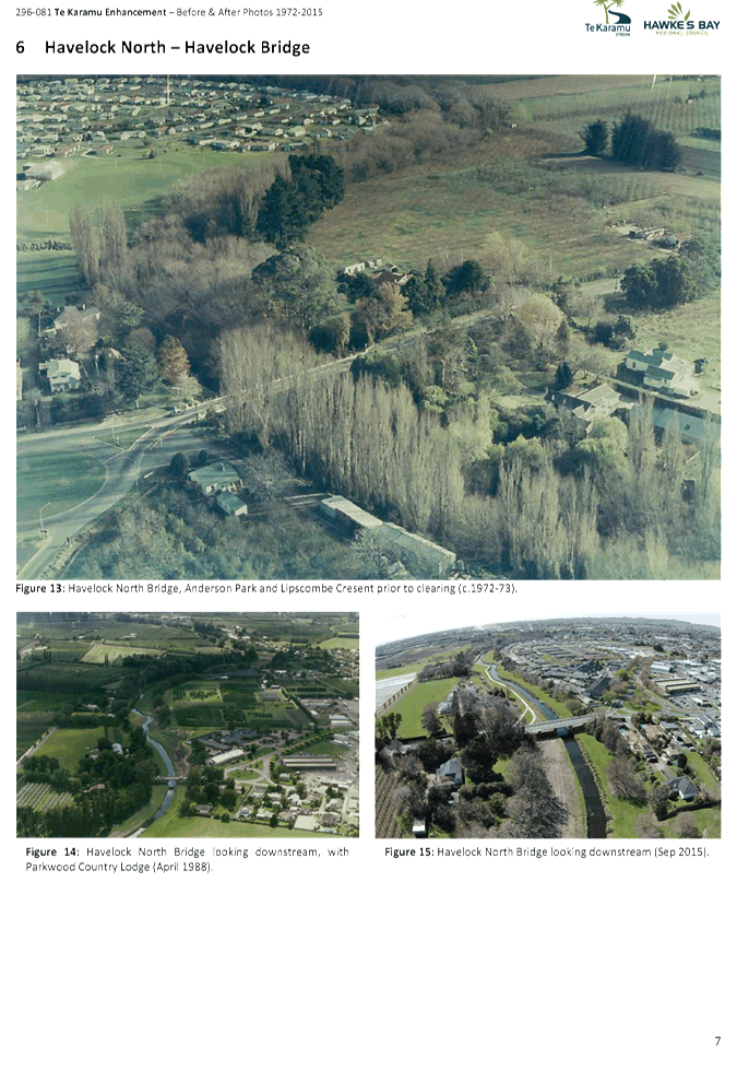
Circulate
before and after photos of the Te Karamu Enhancement.
|
A Rewcastle / S Cave
|
Attached
for information.
|
|
296-081 Te Karamu
Enhancement Before & After Photos 1972-2015
|
Attachment 2
|
HAWKE’S BAY REGIONAL COUNCIL
Environment
and Services Committee
Wednesday 11 May 2016
SUBJECT: Call for any Minor Items Not on the Agenda
Reason for Report
1. Under standing orders, SO 3.7.6:
“Where an item is not on the agenda
for a meeting,
(a) That item
may be discussed at that meeting if:
(i) that
item is a minor matter relating to the general business of the local authority;
and
(ii) the
presiding member explains at the beginning of the meeting, at a time when it is
open to the public, that the item will be discussed at the meeting; but
(b) No
resolution, decision, or recommendation may be made in respect of that item
except to refer that item to a subsequent meeting of the local authority for
further discussion.”
2. The Chairman will request any items to be added for discussion at
today’s meeting and these will be duly noted, if accepted by the
Committee by resolution, for discussion as Agenda Item 14.
|
Recommendation
That the
Environment and Services Committee accepts the following minor items not on
the agenda, for discussion as item 14.
|
|
Mike Adye
Group Manager
Asset Management
|
Iain Maxwell
Group Manager
Resource Management
|
HAWKE’S BAY REGIONAL COUNCIL
Environment
and Services Committee
Wednesday 11 May 2016
Subject: KOHUPĀTIKI MARAE -
AWA ENHANCEMENT FOR MATATINI
Reason for Report
1. Kohupātiki
Marae is requesting assistance from HBRC, in the lead up to the 2017 Matatini,
to:
1.1. Improve the
state of the river bed adjacent to Kohupātiki Marae and Whakatu
1.2. Ensure water
is flowing at a meaningful level in the Karewarewa stream, at Bridge Pa and
Pakipaki, in February 2017.
2. Presentations
will accompany this report from:
2.1. Kohupātiki
Marae will present an overview of the Ngāti Hori Management Plan as well
as the significance of Matatini to the regional community. They will also
provide an account as to the need to have the awa (river) presented in the best
possible state at the time of Matatini.
2.2. To achieve
this staff are formulating options for improving the state of the river bed
adjacent to Kohupātiki Marae via trials that could then be used in a
broader context depending on the trial outcomes.
3. Staff have
worked in partnership with Marae representatives to prepare this briefing
paper.
Background
Naming
Convention of “the awa”
4. The main awa of
the Karamu catchment is recognised by different names depending on the location
and the history of a particular reach. At Whakatu and Clive the full Māori
name of the awa is the ‘Ngaruroro moko tuararo ki rangatira’.
Presently most know the river as the Clive or lower Clive, upstream around the
confluence of the Raupare it becomes the Karamu Stream and further up the
Awanui where the Irongate Stream joins the Karamu. For the purpose of
this briefing paper the river will be referred to as “the awa”
except at Bridge Pa where it will referred to as the Karewarewa Stream
downstream of Raukawa Road, and the Paritua Stream upstream of Raukawa Road.
5. Kohupātiki
Marae acknowledges the whakapapa that interconnects them to all those other
marae and whanau who belong to the greater Heretaunga takiwa (region).
Ngāti
Hori Management Plan
6. In
2012 the Ngāti Hori Management Plan was adopted by Kohupātiki Marae
which saw Operation Patiki implemented. This management plan was presented to
the HBRC Maori Committee at Kohupātiki Marae in
2013.
7. The plan is
based around the following priorities and values of Ngāti Hori in
freshwater management:
7.1. Achieving
sufficient water flow
7.2. Improving
water quality
7.3. Protection
and restoration of traditional riparian vegetation
7.4. Protection
and restoration of fish and fish habitat.
8. To date,
significant work has been completed focusing on protecting and restoring traditional
riparian vegetation. This mahi (work) has involved a greater community network
including schools, whanau, visitors, friends, sympathetic organisations and
local authorities. As a result it is now being replicated at many localities
along the awa from the coast to 35 km upstream at Bridge Pa.
9. They now wish
to address the other three priorities (7.1, 7.2 and 7.4 above).
10. The whanau of Kohupātiki
Marae recognises its responsibility as Kaitiaki and said by Akinehi Paipper “we
must ensure freshwater fish species enter and depart in hospitable waters. If
they are Happy we are Happy”.
Te Matatini
11. “Te Matatini” is a significant cultural
festival and the pinnacle event for Māori performing arts. Held every two
years, it is one of the most highly anticipated events for performers, their
whānau and the mass of passionate kapa haka fans throughout the world.
Hosted in a different city each time, the festival draws thousands of people
who come to witness the best of the best.” http://www.tematatini.co.nz/events/
12. Te Matatini also encourages Māori performers to display those
issues that are impacting on the lives of Māori whānau today. The quality of the waterways features on many
marae agendas nationally, including Kohupātiki Marae.
13. Kohupātiki Marae whānau looks to this project to support their matauranga Māori values, to
ensure their kaitiakitanga is practised and achieved for the benefit of all
within the Heretaunga takiwa.
14. With Te Matatini coming to Heretaunga in February 2017,
Kohupātiki
will be one of many host Marae. As hospitality, manakitanga, whanaungatanga are
paramount for host marae, Kohupātiki would like their awa (Ngaruroro/Karamu) to reflect
their values and Mana. Many of the host marae are located adjacent to awa fed
from the Karamu catchment and in particular the Ngaruroro/Karamu.
15. The awa will also be a focus leading into Matatini as part
of the dedication of pou to acknowledge "Tanenuiarangi Pa" at the
historic site on the right bank, during which time waka are proposed to travel
upstream from Clive.
Lower
Ngaruroro Scheme History
16. Between 1962 and 1975 a comprehensive flood control scheme
involved a complete diversion of the Ngaruroro River starting immediately upstream
of what is now Pakōwhāi Regional Park, diverting flow down what was then its
overflow channel and combining with the Tutaekuri River at the coast.
17. Prior to the flood control scheme, during the extreme flood
event of 1867, the Ngaruroro River changed its course from the Irongate and
Karamu Stream through what is now Flaxmere joining the Karamu Stream upstream
of Havelock North. The course of the Lower Ngaruroro River downstream of
Pakōwhāi was again changed
by the HB Catchment Board in the late 1960’s away from flowing past Kohupātiki Marae into the
channel it is in today. Isolated sections with gravel substrate remain
throughout the old channels, however reduced flow, and sediment and nutrient
loading means that aquatic weed and sediment are present throughout much of the
lower Karamu catchment including the section of the Old Ngaruroro (Clive) River
adjacent to Whakatu and Kohupātiki Marae.
18. Aquatic plant communities cover most of the bed of the
lower Karamu catchment year-round. Emergent water celery and watercress extend
out from the margins through summer and autumn. HBRC actively controls aquatic
plants by periodic cutting by weedboat. This clears the channel of weed but
does not impact on their rooting structure and therefore they continue to
regrow.
19. The weed boat operates from the Awanui Stream (Turamoe Rd)
and the Irongate Stream (Maraekakaho Road) downstream to the Karamu-Raupare
Stream confluence (floodgates) 6 to 8 times each year (September to June). The
weed boat also operates between the Karamu-Raupare Stream confluence (CS17)
downstream to the Farndon Road pump station (CS7) 3 times each year
(July/December/March).
20. Land use adjacent to the Old Ngaruroro (Clive) River
includes stock grazing, native revegetation, horticulture, industrial, and
residential.
21. Cutter-suction dredging and pumping to sea occurred on the
lower Old Ngaruroro (Clive) River in 2000 (to approx. 200 m upstream of
the Rowing Club, involving approx. 60,000 m³) and in 2010 (to approx.
50 m upstream of the Clive Bridge). The requirement for dredging is
subject to a 2 year survey, a design depth of approximately 2m, and is expected
to be required every 10-12yrs at a cost of approximately $700k to $800k.
22. Sediment depth varies along the reach downstream of the
Raupare confluence to the Clive Bridge. It is estimated that 6,000m³
of sediment is present in a 1km reach of river downstream of Kohupātiki Marae.
Current State
of the Ngaruroro
23. Kohupātiki believe the awa is not in a state that will reflect
well on the region, marae community and local authorities responsible for the
wellbeing of the awa. This is due to many factors; the most urgent relating to
sedimentation of the riverbed and aquatic weed growth in the lower reaches and
water flow in the upper reaches. These factors do impact on ecosystem health,
traditional use and aesthetics.
24. Kohupātiki requests the Council recognise this opportunity to
showcase this region in 2017 and take steps in supporting the implementation of
work programmes that will enable the awa to be presented in a state all can be
proud of.
Options for
Improvement
25. Staff have completed preliminary investigations into
strategies for removing weed and sediment from the river bed. These are based
on either a combination of weed cutting and mechanical excavation via digger,
or auger suction via dredge. To fully consider the dredging option a consultant
investigation is required. Specifically this investigation is required to
confirm;
25.1. practical feasibility
25.2. consent requirements
25.3. disposal options for
excavated sediment and weed
25.4. long term viability
25.4.1. ecological and social
benefits
25.4.2. rate of re-sedimentation
25.4.3. rate of weed re-invasion
25.5. cost.
26. A full investigation by
consultants to prepare a detailed project plan and cost estimate for the auger
suction via dredge methodology will cost $30,320. A rough order cost estimate
has been supplied by Southwater Dredging and Water Management indicating a cost
of $300,000 to remove and dispose of 6,000m³ of sediment over a 1km reach.
27. This work is realistically
unable to be completed in time for the Matatini festival, and staff suggest
this approach may be one of a suite of possible remediation options considered
through the TANK process.
28. For Matatini staff propose
a mechanical excavation trial adjacent to Kohupātiki Marae ahead of the "Tanenuiarangi Pa" pou unveiling and
Matatini. The experience gained through this trial will assist in confirming
the practical feasibility of mechanical excavation of sediment and its impact
on weed growth. The immediate outcome of the trial will be that part of the
reach of the river bed adjacent to Kohupātiki Marae is sediment and weed
free for Matatini.
29. Indicative cost of a
mechanical excavation trial over a 200m reach is approximately $25,000 subject
to consent and sediment disposal requirements. Note that the proposed work may
not extend for the full width of the river.
30. It is further proposed
that additional weed cutting and catching of weed upstream of Kohupātiki
at the Karamu - Raupare confluence is scheduled prior to Matatini. The cost
estimate for this work is $20,000, but this work may be accommodated by
adjusting timing for programmed maintenance work.
Recommended Work Programme 2016-17
31. Options
for weed and sediment removal with rough order cost estimates are summarised in
the table below:
|
Option
|
Methodology
|
Cost
|
|
Trial
Excavation - Digger
|
Excavate 100m X 30m
reach using Long Reach Digger
including sediment and weed disposal
Excavate 100m X 30m
reach using 12 tonne Digger including sediment and weed disposal
|
$12,500
$12,500
|
|
Extra Weed
Cutting & Catching
|
Extra weed
cut over entire length and catch at Karamu / Raupare confluence
|
$20,000
|
|
|
TOTAL
|
$44,500
|
32. In addition to the above
it is recommended that further investigation is undertaken during the 2016-17 financial
year for auger suction dredging at a cost of $30,200.
33. The costs for all work
proposed can be met through the Heretaunga Plains Flood Control Scheme –
Rivers. This Scheme includes the awa (Clive River downstream of the Raupare /
Karamu confluence to the sea) and includes budget for the development of a long
term capital works programme to upgrade the river flood defences, and a portion
of this provision could be diverted to meet this cost.
Water Augmentation at Bridge Pa /
Pakipaki
34. Providing an appropriate
flow level in the Karewarewa Stream adjacent to Mangaroa Marae at the time of
Matatini depends on water being available upstream of the Mangaroa Marae.
Options for augmentation of stream flows will be investigated, and developed,
if suitable. Any arrangements should be finalised some months prior to Matatini
to ensure sufficient water will be available to maintain appropriate flow
levels at the time required.
35. Staff are seeking
direction from Council on what role HBRC should take in assisting Marae to
prepare for Matatini.
Decision Making
Process
36. Council
is required to make every decision in accordance with the requirements of the
Local Government Act 2002 (the Act). Staff have assessed the requirements
in relation to this item and have concluded:
36.1. The decision
does not significantly alter the service provision or affect a strategic asset.
36.2. The use of
the special consultative procedure is not prescribed by legislation.
36.3. The decision
does not fall within the definition of Council’s policy on significance.
36.4. The persons affected by this
decision are the ratepayers to the Heretaunga Plains Scheme – Rivers, and
Marae and their associated communities adjacent to rivers across the Heretaunga
Plains
36.5. Options that
have been considered are set out in the briefing paper.
36.6. The decision
is not inconsistent with an existing policy or plan.
36.7. Given
the nature and significance of the issue to be considered and decided, and also
the persons likely to be affected by, or have an interest in the decisions
made, Council can exercise its discretion and make a decision without
consulting directly with the community or others having an interest in
the decision.
|
Recommendations
1. The Environment and Services Committee receives and notes the
“Kohupātiki Marae - Awa Enhancement for Matatini”
report.
2. The Environment and Services Committee recommends that Council:
2.1. Agrees that the decisions to be made are not significant under the
criteria contained in Council’s adopted Significance and Engagement
Policy, and that Council can exercise its discretion and make decisions on
this issue without conferring directly with the community and persons likely
to be affected by or to have an interest in the decision.
2.2. Agrees to staff working in partnership with Kohupātiki Marae to trial
excavation of sediment and weed over approximately 200m in the vicinity of
the Marae prior to Matatini.
2.3. Agrees to staff working in partnership with Mangaroa Marae and
upstream landowners to augment flows in the Karewarewa Stream throughout
Matatini.
2.4. Agrees to continue investigations to assess options for reducing
the impact of seasonal aquatic weed growth and sedimentation throughout the
Karamu Stream and Clive River schemes.
|
|
Anthony Rewcastle
Development Officer
Open Spaces
|
Steve Cave
Asset Manager
Open Spaces
|
|
Gary Clode
Manager REGIONAL ASSETS
|
Mike Adye
Group Manager
Asset Management
|
Attachment/s
There are no
attachments for this report.
HAWKE’S BAY REGIONAL
COUNCIL
Environment
and Services Committee
Wednesday 11 May 2016
Subject: Te Mata Park 10 Year
Management Plan
Reason for Report
1. At their
meeting on 30 March 2016, Council agreed with the Environment and Services
Committee recommendation to:
1.1. Retain the allocation of
$500,000 in the Long Term Plan for the Te Mata Park Visitor & Education
Centre for the period to 30 June 2016 pending consideration of a final 10 year
Management Plan for Te Mata Park to be prepared and presented to Council prior
to that date.
2. The Te Mata
Park Trust Board has now completed their 10 year Management Plan for
consultation with the community. A copy of the Plan is provided as Attachment
1 and 2 for information. Representatives from the Trust will present at the
meeting to respond to any queries that the Committee may have.
3. The 10 year
Management Plan includes a number of improvement works and indicative
costs. The Trust presents the works for which they seek funding from HBRC
in the attached (Attachments 3 and 4) Te Mata Park Trust Board Community
Facilities Fund Application. In this document the Trust has assessed the
projects against the HBRC Community Facilities Fund criteria which has been
provided to them by staff.
4. Staff have also
assessed these projects against Council’s criteria for Community
Facilities Fund applications. This paper sets out that assessment and
requests that the Committee recommend to Council which projects they believe
should be supported by the fund.
Discussion
5. A copy of the
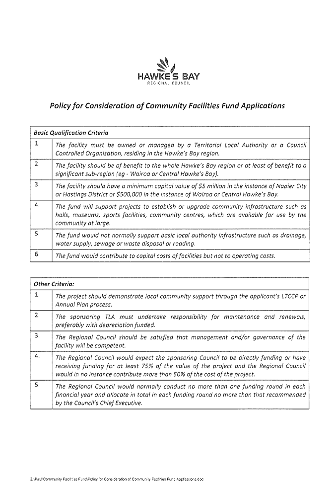
policy for consideration of Community Facilities Fund applications adopted by
Council is attached (Attachment 5). Staff have assessed the
funding sought against this policy.
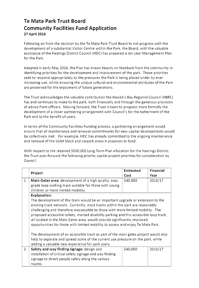
6. The following
improvement works have been identified by the Trust as potential items for HBRC
funding.
|
|
Item
|
Detail
|
Indicative cost
|
|
1
|
Main gate development
|
Loop track
|
$40,000
|
|
2
|
Safety and way finding
signage
|
|
$40,000
|
|
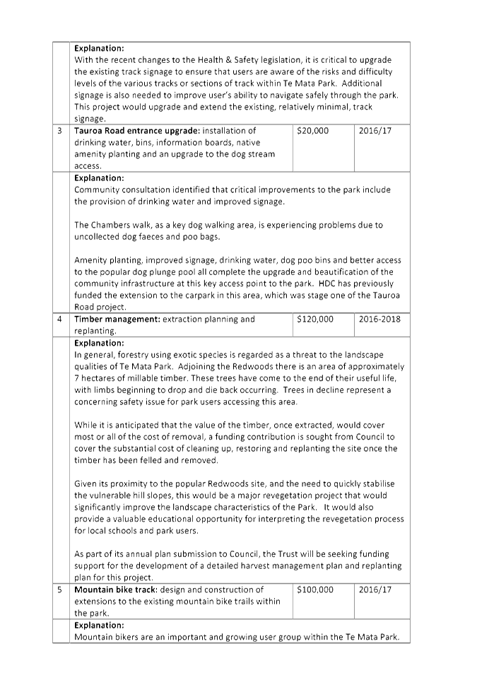
3
|
Tauroa Road entrance
upgrade
|
Drinking a rubbish
facilities and information signage
|
$20,000
|
|
4
|
Timber management
|
Harvesting and
replanting of pine blocks
|
$120,000
|
|
5
|
Tracks
|
Mountain bike track
extensions
|
$100,000
|
|
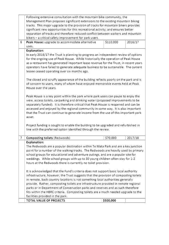
6
|
Peak House
|
upgrade
|
$110,000
|
|
4
|
Amenity additions -
Redwoods
|
Composting toilets
|
$70,000
|
|
|
|
|
$500,000
|
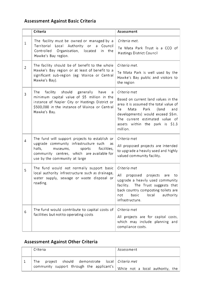
7. The overall
project has been assessed against Council’s policy for consideration of
Community Facilities Fund applications in the table following.
|
|
Criteria
|
Assessment
|
|
1
|
The facility must be owned
or managed by a Territorial Local
Authority or a Council Controlled Organisation, located in the Hawke's
Bay region.
|
Criteria
met.
Te Mata Park Trust is
a CCO of Hastings District Council
|
|
2
|
The facility should be of benefit to the whole
Hawke's Bay region
or at least
of benefit to a significant sub-region (eg: Wairoa or Central Hawke's
Bay).
|
Criteria met.
Te Mata Park is well
used by the Hawke’s Bay public and visitors to the region
|
|
3
|
The facility should generally have
a minimum capital value of $5 million in the
instance of Napier City or Hastings District or $500,000 in the instance of Wairoa or Central Hawke's Bay.
|
Criteria may be met
The individual projects
are not of the value set by the criteria, however the total value of Te Mata
Park is likely to exceed $5m.
|
|
4
|
The fund will support projects to establish or upgrade community infrastructure such
as halls, museums, sports facilities, community centres, which are available for use by the community at large
|
Criteria met for
some projects
This project is to
upgrade a community facility – Te Mata Park, however some projects,
e.g. timber management, do not fit this criteria.
|
|
5
|
The fund
would not normally support basic local
authority infrastructure such as
drainage, water supply, sewage or waste
disposal or roading.
|
Criteria met for
some projects
This project is to
upgrade a community facility, however projects for which funding is requested
include the installation of composting toilets and drinking water supply.
|
|
6
|
The fund
would contribute to capital costs
of facilities but not to operating
costs
|
Criteria met for
some projects
The majority of
projects are for capital items, however harvesting of the pine block does not
fit this criteria.
It is not clear how
operating costs for the additional facilities for which funding is requested
are to be provided for. Eg Peak House
|
Other
criteria
|
|
Criteria
|
Assessment
|
|
7
|
The project should
demonstrate local community support through the applicant’s LTCCP or
Annual Plan process.
|
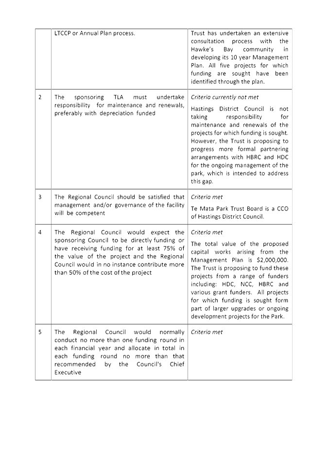
Criteria met
The Trust is not a
local authority, however it has been through an extensive consultation
process with the Hawke’s Bay community to develop its 10 year plan from
which the projects have been identified.
|
|
|
8
|
The sponsoring TLA
must undertake responsibility for maintenance and renewals, preferably with depreciation funded
|
Criteria not met
Hastings District
Council is not taking responsibility for maintenance and renewals of all
projects for which funding is sought. This is discussed in more detail under
8 - 13 below.
|
|
|
9
|
The Regional Council should
be satisfied that management and/or
governance of the facility will
be competent
|
Criteria met
Te Mata Park Trust
Board is a CCO of Hastings District Council.
|
|
|
10
|
The Regional Council would expect
the sponsoring Council
to be directly funding or have
receiving funding for at least
75% of the
value of the project and the Regional Council would in no
instance contribute more
than 50% of the
cost of the project
|
Criteria may be
met
The total value of
proposed capital works as set out in Appendix 2 is in the order of $2,000,000
with a proposal that these are funded from funders including HDC, NCC, HBRC
and grant funded. Te Mata Trust are requesting HBRC to fund 100% of
some items.
|
|
|
11
|
The Regional Council would normally conduct no more
than one funding
round in each financial year and allocate
in total in each funding
round no more than that recommended by the Council's Chief
Executive
|
Criteria met
It is proposed that
appropriate provision is included in the 2016-17 Annual Plan, and subsequent
plans depending on the proposed timing for the projects.
|
|
|
|
|
|
|
8. With reference
to individual projects set out in Attachments 3 and 4, staff
assessment against the criteria is set out in the table below.
|
|
Item
|
detail
|
Comment
|
|
1
|
Main gate development
|
Loop track (Indicative
cost $40k)
|
May be considered as
part of track upgrades/ extensions)
|
|
2
|
Safety and way finding
signage
|
Design and production
($40k)
|
May be considered as
part of track upgrades/ extensions)
|
|
3
|
Tauroa Road entrance
upgrade
|
Drinking water, bins,
information boards, native amenity planting etc ($20k)
|
Does not strictly fit
criteria 5, however is part of the overall upgrade of Te Mata Park
facilities.
|
|
4
|
Timber management
|
Harvest planning and
harvesting
Replanting (120k)
|
No details have been
provided on cost of harvest vs revenue, or plans for post-harvest
planting. This appears to be an operational item.
|
|
5
|
Tracks
|
Mountain bike track
extensions
Installation of safety
and wayfinding signage
($100k)
|
Upgrading/ extension to
tracks could be considered as major upgrade to Te Mata Park.
|
|
6
|
Peak House
|
Upgrade
to accommodate alternative uses ($110k)
|
No clarity provided for
use, and no information provided on ongoing operational and depreciation
costs
|
|
7
|
Amenity additions
|
Composting
toilets ($70k)
|
Does not fit criteria
5, however toilets are installed in open space areas managed by HBRC.
|
9. Criteria 8
requires that the sponsoring TLA must
undertake responsibility for maintenance and renewals, preferably with depreciation funded. HBRC has increased its annual contribution to Te
Mata Park Trust in its 2015/25 LTP to $65,000 per year to fund operational
costs. Te Mata Park Trust utilise this money employ a park caretaker.
10. As far as staff are aware
no financial provision is made by Te Mata Park Trust for depreciation of
current assets/facilities, and therefore their replacement at the end of their
useful life. No information has been provided regarding potential increases
in operational costs associated with the facilities for which funding has been
requested.
11. Staff understand that
currently HDC maintain roads within the Park, including the summit car parking
area, and also roads and carparks that service the Park. In addition
staff understand that HDC will commit to ongoing cleaning and maintenance of
toilet facilities proposed as part of the main gate development. Staff also
understand that the annual contribution by HBRC is the only funding available for
other routine operational costs.
12. Staff are unable to advise
whether or not the current level of operational funding is adequate to maintain
the Park and associated facilities to a defined level of service. Staff
recommend that Council partner with Te Mata Park Trust to develop an asset
management plan for the Park. The park asset management plan would define
the level of service that the Park would provide for its visitors and
stakeholders and identify work that is required to maintain the Park to provide
the defined level of service.
13. The completed Park asset
management plan would then allow the necessary long term costs for managing and
maintaining the Park to be better defined, and options on how that management
and maintenance could best be delivered to be considered.
Decision Making
Process
14. Council
is required to make every decision in accordance with the requirements of the
Local Government Act 2002 (the Act). Staff have assessed the requirements
in relation to this item and have concluded:
14.1. The
decision does not significantly alter the service provision or affect a
strategic asset.
14.2. The use
of the special consultative procedure is prescribed by legislation, and was
included in the consultation on the 2012-22 Long Term Plan.
14.3. The
decision does not fall within the definition of Council’s policy on
significance.
14.4. No persons are directly
affected by this decision.
14.5. Options
are either to carry-over all or part of the funding for the Te Mata Park Trust
to 2016-17, or to decline the request of the Trust to do so.
14.6. The
decision is not inconsistent with an existing policy or plan.
14.7. Given
the nature and significance of the issue to be considered and decided, and also
the persons likely to be affected by, or have an interest in the decisions
made, Council can exercise its discretion and make a decision without
consulting directly with the community or others having an interest in
the decision.
|
Recommendations
1. That the Environment and Services Committee receives and notes the
“Te Mata Park 10 Year Management Plan” report.
2. The Environment and Services Committee recommends that Council:
2.1. Agrees that the decisions to be made are not significant under the
criteria contained in Council’s adopted Significance and Engagement
Policy, and that Council can exercise its discretion and make decisions on
this issue without conferring directly with the community and persons likely
to be affected by or to have an interest in the decision.
2.2. Considers the request to fund work set out in the Te Mata Park
proposed capital works programme and agrees whether or not to fund each of
the following items with funding being sourced from Council’s community
Facilities Fund.
|
|
Item
|
Detail
|
Year
|
Indicative
cost
|
|
1
|
Main gate
development
|
Loop track
|
2016-17
|
$40,000
|
|
2
|
Safety and
way finding signage
|
Design and
production
|
2016-17
|
$40,000
|
|
3
|
Tauroa
Road entrance upgrade
|
Drinking water, bins,
information boards, native amenity planting etc
|
2016-17
|
$20,000
|
|
4
|
Timber
management
|
Harvest planning and
harvesting
Replanting
|
2017-18
2018-19
|
$120,000
|
|
5
|
Tracks
|
Mountain bike track
extensions
Installation of
safety and wayfinding signage
|
2016-17
|
$100,000
|
|
6
|
Peak House
|
Upgrade to
accommodate alternative uses
|
2016/17
|
$110,000
|
|
7
|
Amenity
additions
|
Composting toilets
|
2017-18
|
$70,000
|
2.3. Proposes to
Te Mata Park Trust that the two organisations work in partnership to develop
a Park asset management plan to inform its ongoing operational needs.
The plan would include estimated long term costs for managing and maintaining
the Park, and options on how that management and maintenance could best be
delivered and funded. It should be noted that the cost of this work may
be sought by the Trust through a submission to the HBRC Annual Plan 2016-17.
|
|
Steve Cave
Asset Manager
Open Spaces
|
Mike Adye
Group Manager
Asset Management
|
Attachment/s
|
1
|
Te Mata Park
Management Plan May 2016
|
|
Under
Separate Cover
|
|
2
|
Te Mata Park
Management Plan Appendices May 2016
|
|
Under
Separate Cover
|
|
3
|
Te Mata Park
Trust Board Community Facilities Fund Application
|
|
|
|
4
|
Te Mata Park:
Proposed Capital Works Programme 2016-2020
|
|
|
|
5
|
Policy for
Consideration of Community Facilities Fund Application
|
|
|
|
Te
Mata Park Trust Board Community Facilities Fund Application
|
Attachment 3
|
|
Te Mata Park: Proposed
Capital Works Programme 2016-2020
|
Attachment 4
|


|
Policy for Consideration of
Community Facilities Fund Application
|
Attachment 5
|
HAWKE’S BAY REGIONAL COUNCIL
Environment
and Services Committee
Wednesday 11 May 2016
Subject: Upper Tukituki Scheme
Review
Reason for Report
1. This report
provides the Committee with an update on:
1.1. Gravel issues
on the Upper Tukituki rivers
1.2. A review of
the Upper Tukituki Flood Control Scheme rating review, and
2. The paper is
presented in two parts covering the above issues.
3. The paper:
3.1. Updates the
Committee on what specific action is currently underway seeking solution(s) to
deal with the impact that river bed gravel accumulation is having on some land
adjacent to stopbanks, and;
3.2. Seeks a
decision on whether or not Council should proceed with reviewing the basis for
setting targeted rates levied to either fund the current level of service for
the Scheme, ie the ongoing maintenance and improvement for flood protection
purposes, or fund an increased level of service including additional gravel
management measures.
Background
4. Over the past
several years staff have discussed with Upper Tukituki Scheme ratepayers a
number of issues regarding the Upper Tukituki Scheme and the state of the
rivers that are managed as part of the Scheme. These issues include the
following:
4.1. River bed
levels – specifically the build-up of gravel in some rivers and the
impact that is having on their properties which neighbour the rivers.
4.2. Increased
ground water levels and the challenges of maintaining productive land through
increased on farm drainage costs.
4.3. The potential
impact of climate change and the risk to the level of flood protection provided
by the Scheme;
4.4. The amount
paid in targeted rates to fund the ongoing maintenance and improvement of the
Scheme, and whether or not individual ratepayers are receiving fair value for
the rates that they pay.
5. A community
focus group was formed in 2015 to assist HBRC work through these issues.
The group last met on 1 March 2016. No further meetings of the group have
been arranged, however staff are keen to continue to work with the group.
The decisions made by Council in considering this briefing paper will allow
staff to provide the group with an intended programme and timelines to address
the range of above issues.
Gravel
Background
6. The report
(Upper Tukituki Catchment Control Scheme, Investigations and proposed Scheme, G
J Williams August 1985) upon which the Upper Tukituki Scheme as we know
it today was based, recognised that a sustained increase in the rate of gravel
extraction would be needed to control the aggradation of gravel. The
report states that “the removal of excess bed material is the only
feasible option in the controlled (confined by river control works and
stopbanks) reaches of the rivers. Extraction must continue
indefinitely.”
7. There is a
significant source of sediment feeding the rivers of the Ruataniwha catchment.
Of these the Waipawa and Upper Tukituki rivers and their tributaries contribute
the largest quantities of sediment, in particular gravel. Excessive gravel
build-up in the river beds can present a risk to the flood protection scheme
due to loss of flood carrying capacity and/or increased risk of damage to live
tree edge protection which confines the “active channel” of the
river.
8. Figure 1
illustrating the “active river channel”
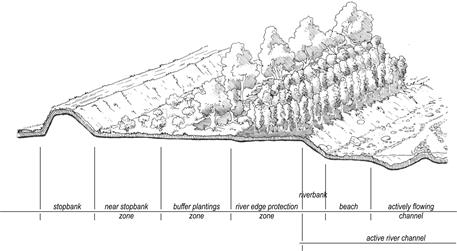
9. Gravel
extraction together with beach raking are used to manage the river bed levels
within reaches of rivers where there are river control schemes but in recent
times with a downturn in the economy the demand for gravel has fallen quite
severely in the Upper Tukituki Scheme rivers. Since 2008/2009 the annual volume
of gravel extracted from all of the Upper Tukituki Rivers has fallen
substantially, from in excess of 100,000m3/year to less than 20,000m3.
10. Gravel is extracted by
commercial extractors at no cost to the Scheme.
11. A number of property
owners who pay targeted rates to fund the Upper Tukituki Flood Control Scheme
have complained that the accumulation of gravel in some of the Upper Tukituki
rivers is resulting in elevated ground water levels on their properties, or
increased flood frequency, both of which are adversely impacting on the
productivity of their land. Particular concerns have been expressed by
land owners adjacent to the Tukituki and Makaretu Rivers.
12. Attached to this briefing
paper as Appendix 1 is a map showing the locations of cross sections that are
regularly surveyed on the Upper Tukituki rivers. Cross section locations
are referred to later in this report. Cross sections are re-surveyed
every 3 years where gravel is extracted and every 6 years
elsewhere. The data is used to monitor flood capacity in the
rivers, and to determine availability of gravel for extraction.
13. Figures 2 and 3 below
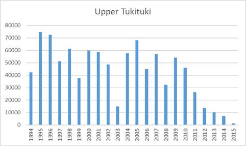
graph the volumes of gravel extracted annually from the Upper Tukituki River
and the Waipawa River since 1994. These graphs show clearly the
significant downward trend in extracted volumes since 2008/2009.
14. It should also be noted
that the majority of the gravel extraction from these rivers occurs in the
vicinity of SH 2 and SH 50 as these locations are easily accessible by
extractors and travel distances are minimised between the point of extraction
and point of use. River reaches away from easy access points are the
worst affected by gravel build-up.
15. Figure 2 – Gravel
volumes extracted from Upper Tukituki River between 1994 and 2015
|
|
|
|
|
|
|
|
|
|
|
|
|
|
|
|
|
|
|
|
|
|
|
|
|
|
|
|
|
|
|
|
|
|
|
|
|
|
|
|
|
|
|
|
|
|
|
|
|
|
|
|
|
|
|
|
|
|
|
|
|
|
|
|
|
|
|
|
|
|
|
|
|
|
|
|
|
|
|
|
|
|
|
|
|
|
average
|
|
42,682
|
cubic
metres/year
|
16. Figure 3 - Gravel volumes
extracted from Waipawa River between 1994 and 2015
|
|
|
|
|
|
|
|
|
|
|
|
|
|
|
|
|
|
|
|
|
|
|
|
|
|
|
|
|
|
|
|
|
|
|
|
|
|
|
|
|
|
|
|
|
|
|
|
|
|
|
|
|
|
|
|
|
|
|
|
|
|
|
|
|
|
|
|
|
|
|
|
|
|
|
|
|
|
|
|
|
|
|
|
|
|
average
|
|
61,895
|
cubic
metres/year
|
17. Data collected over the
period 1994 to 2014 has been analysed for the Waipawa River and the Upper
Tukituki River.
18. Figure 4 below for the
Waipawa River shows that there has been a decrease in the above grade gravel
availability from a peak of nearly 2 million m3 down to
about 1.5 million m3 and the average (net)
availability has reduced from approx. 1,600,000m3 to approx.
1,000,000m3 over the 20 year period from 1994 to 2014. It also shows
that increased extraction has occurred below grade from 0.1 million m3
to 0.5 million m3 reflecting the fact that extraction has
been concentrated in reaches nearest access to main roads. The overall trend
shows that gravel extraction and other river management activities (eg beach
raking) has resulted in an overall reduction in the total gravel quantity above
the ideal grade line.
Figure 4: Waipawa Gravel Trends. 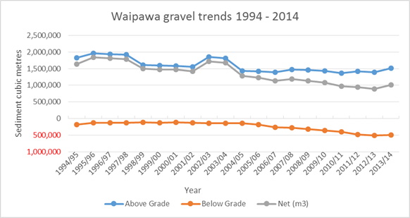
19. It
should be noted however in terms of Mean Bed Levels that in 1995 the average
bed level above grade was 0.47m and below grade it was -0.19m and a net of
0.37m. In 2012 the average bed level above grade was 0.60m and below grade it
was -0.38m and a net of 0.23m. This means that the situation in areas
where gravel is accumulating is worsening.
20. Similarly for the Upper
Tukituki there has been a small reduction in above grade gravel availability
but a small increase in the average (net) trend of gravel above the ideal grade
line by about 250,000m3 over the 20 year period, with the below
grade volumes recovering from -0.9 million m3 to -0.5 million m3.
21. Figure
5: Upper Tukituki Gravel Trends. 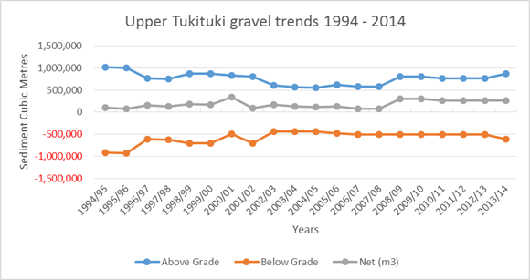
22. In terms of Mean Bed
Levels the Upper Tukituki River shows similar trend to the Waipawa River with
the average bed level in 1995 above grade by 0.35m and below grade by -0.27m,
compared with the average bed level in 2015 being above grade 0.48m and below
grade -0.34m and a net of 0.03m.
23. Gravel availability
assessments prepared in 2015 clearly show the locations where there is surplus
gravel. While the quantity of surplus gravel is greater in the Waipawa
River, staff have received little enquiry from ratepayers adjacent to the
Waipawa River regarding elevated water levels impacting on their land.
The majority of this sort of enquiry has come from landowners adjacent to the
Upper Tukituki River upstream of its confluence with the Tukipo River and
downstream of Burnside Road.
24. Figures 6 and 7 –
Gravel availability in Waipawa and Upper Tukituki Rivers
25. From the above it can be
concluded that gravel extraction and other maintenance activities, such a beach
raking, has generally been sufficient over the past 20 years to maintain gravel
in the Upper Tukituki and Waipawa rivers without a significant increase in the overall
quantity, however because extraction has not occurred uniformly throughout the
length of these rivers, a surplus of gravel is continuing to accumulate in some
areas.
Options for
addressing reaches in gravel surplus
26. There are two possible
approaches to increase the amount of gravel extracted from sections of the
rivers where gravel is continuing to accumulate.
26.1. Approach 1
– Require or encourage commercial extractors to extract the gravel at no
cost to the Scheme. Legal advice received indicates that HBRC does not have the
legal ability to direct extractors to specific areas where extraction is
required. This approach, if a legal mechanism is or could be available, could
result in an increase in transport costs for extractors, which they in turn
would expect to recover through an increased cost of their product.
26.2. Approach 2
– HBRC or others extract the excess gravel from reaches where the
accumulation is impacting on adjacent properties.
Approach 1
27. It is imperative for
Council to have an effective framework for the ongoing management of the gravel
resource within the region, supported by robust science and processes. This was
the subject of a paper to Council on 09 November 2010 where a scoping report
was presented that outlined the issues and proposed a way forward.
28. The scoping report
identified the issues associated with the current management of the
region’s river bed gravel resource that when completed would:
28.1. Improve Council’s
understanding of riverbed gravel transport and the impact of gravel extraction
on flood protection works and coastal processes.
28.2. Enable Council to review
its management regime for assessing the gravel resource and for managing its
extraction.
28.3. Examine the future
demand for the resource working with the extraction industry.
28.4. Inform co-management
discussions with regard to the gravel resource and its management with Treaty
Claimant Groups.
29. The scoping report adopted
by Council included a prioritised programme of work that could be accommodated
in a 6 year time span. This work is programmed for completion in 2016-17.
The last update to Council on this programme of work was provided to the
Environment and Services Committee at their meeting on 15 December 2015.
30. The table below shows the
progress to date and target completion dates.
|
Issue No.
|
Issue
|
Completion date
|
Target date for
completion
|
|
1
|
Hydrological review
|
2011-12
|
Completed
|
|
2
|
Gravel Supply and Transport
|
Begun and ongoing
|
June 2017
|
|
3
|
Gravel Resource Inventory
|
2015
|
Completed
|
|
4
|
Implications for Flood Protection
|
|
October 2016
|
|
5
|
Gravel Demand and Forecast
|
2014
|
Completed
|
|
6
|
Gravel Monitoring & Determination of Resource
Availability
|
Begun 2015
|
Completed
|
|
7
|
Instream Ecological Effects
|
Underway, due 2015*
|
June 2016
|
|
8
|
Riverbed Birds and Flora
|
Underway, due 2015*
|
June 2016
|
|
9
|
Tangata Whenua Values
|
Ongoing
|
June 2017
|
|
10
|
Effectiveness of Beach-raking
|
2013
|
Completed
|
|
11
|
RMA Issues
|
Commenced
|
Draft
in August 2016
|
|
12
|
Allocation
and Financial Mechanisms
|
Commenced
|
Draft
in August 2016
|
|
13
|
Riverbed Gravel
Management Plan
|
Staff
may be able to bring completion date forward, but this will depend on the
outcome of 11 and 12
|
June 2017
|
*
Items 7 and 8 were put on hold to fit in with the consultant’s work
programme
31. Issue No 11 and 12 relate
directly to Approach 1. Legal advice has confirmed that HBRC does not
currently have the legal ability under its current Regional Resource Management
Plan or gravel allocation process to direct extractors to take gravel from
river reaches where gravel is currently accumulating. Item 12 above
includes a review to identify an approach that would address this. This
work was originally intended to be undertaken during the 2017 calendar year but
has been brought forward in order to inform options to deal with gravel issues
on the Upper Tukituki Scheme rivers.
32. The work has been
commissioned and will be completed over the next few months. It will
involve a thorough evaluation of an optimal permitting system for gravel
extraction and an investigation of a range of plausible options for managing
river bed gravel to achieve a balance between flood control needs, the
avoidance of unintended consequences such as extractors moving to land based
sources, and the financial and practical issues for extractors operating in a
competitive market. Staff are working towards the possibility of updating
Committee members on this work through a workshop session immediately following
the next E&S Committee meeting programmed for 24 August 2016.
33. The final stage of the
gravel review programme will be the development of a Riverbed Gravel Management
Plan. This Plan will be a non-statutory document, and will have a series
of recommendations for its implementation. These may include
recommendations for changes to the current consenting regime and/or
HBRC’s Regional Resource Management Plan.
Approach 2
34. Removing the surplus of
gravel from the reaches where it is impacting on adjacent properties is an
option. While it will be relatively easy to commission a contractor to
undertake the necessary work, the question is who should pay?
35. Indicative costs are
estimated to be
35.1. $5.50/m3 -
$6.50/m3 to remove gravel from above the water level and transport
approx. 750m. This would require the material to be deposited on private land
in the vicinity of the stopbank and would therefore require land owner
agreement.
35.2. To transport greater
distance would substantially increase the cost. If it was to be removed
by an extractor and transported to their plant for processing an indicative
cost of over $17/m3 has been provided
36. Landowners between cross
section 45 and 60 on the Upper Tukituki River (see Figure 6 above) are
adversely affected by high ground water levels and are very keen to explore
ways to reduce the gravel accumulation in this reach of the river. Figure
6 shows that the gravel accumulated in this reach totals approximately 350,000
m3 above the ideal grade line for the river. This equates to a
cost of $2,100,000 if the material were to be removed to a stockpile close to
the river, or over $6M if it were to be transported to Heretaunga Plains.
37. Alternatively if an annual
programme of extraction of say 20,000m3 were to take place that may
be sufficient to reduce the accumulation over time. The cost could be in the order
of $120,000/year if there was agreement from adjacent landowners to stockpiling
the material on their land.
38. An issue for any of these
options will be who should pay? As stated in paragraph 6 at the time of
establishment of the Scheme no provision was included for gravel
extraction. At that time it was envisaged that gravel extraction would
need to continue utilising commercial gravel extractors. Therefore there
is no provision within the rates collected to fund the scheme to meet any
additional costs associated with gravel extraction.
39. The options therefore
available are for the land owners affected, or for the Upper Tukituki Scheme
(and therefore all Scheme ratepayers) to meet the cost of extraction.
40. It should also be noted
that while the focus in this briefing paper is on the Waipawa and Upper
Tukituki Rivers, landowners adjacent to the Makaretu River are also
experiencing additional flood risk to their land as a result of gravel
accumulation. As this part of the Scheme is not stopbanked, flood flows
flow across adjacent land depositing gravel and other debris and damaging
crops.
Allocation of rates
41. The Upper Tukituki Scheme
has an annual budget for maintenance, administration and improvement of approx.
$850,000 /year. 17.5% of this is sourced from general rating sources, and
the remaining 82.5% is funded from a targeted rate levied on properties the
benefit from the Scheme.
42. The targeted rates are
levied on the basis of a classification system that was developed and
introduced in the late 1980’s under the Soil Conservation and Rivers
Control Act 1941.
43. Currently the scheme
includes 6,351 properties; has a total targeted rate take of approx. $690,000
(+ GST).
44. The table below gives an
indication of the level of targeted rates individual properties receiving
benefit from the Scheme are paying:
|
Ratepayers paying greater than
$16,000 incl GST
|
2
|
|
Ratepayers paying greater than
$1,000 incl GST
|
125
|
|
Ratepayers paying greater than $100
incl GST
|
905
|
|
Ratepayers paying less than $100
incl GST
|
5320
|
45. The current basis of
rating for the Upper Tukituki Scheme was for flood protection and did not
include provision for extraction of gravel. If Council determines that
the Upper Tukituki Scheme should meet the cost of extracting gravel, then this
will be an additional service provided and accordingly the current basis of
rating should be reviewed to provide a fair and equitable basis for the costs
to be distributed. This will require a complete review of the basis of
rating for the Scheme.
46. While current legislation
is not as prescriptive as previous legislation in terms of the range of issues
for consideration in determining a rating system, it is implicit in its
expectation that Council will make judgements on the fairness and equity of
rating systems as part of their decision making.
47. Since the current basis
for rating allocation was developed in 1985 there has been ongoing changes in
land use (particularly around the urban fringe), changes to maintenance
techniques, approaches and priorities; and if the Ruataniwha Water Storage
Scheme proceeds there could be considerable changes to land ownership, land
value (determined by productive potential) and land use. In addition a
number of anomalies in the current rating Scheme have been identified during
the work undertaken on this review to date.
48. In addition rating
legislation has changed since the original classification was developed.
Under the previous legislation the basis for rating was aligned to benefit
received. While this principle remains, new legislation requires the
basis of rating to be aligned to the service provided to the property.
Accordingly significant adjustments to rating Schemes established under
previous legislation cannot be made.
49. For these reasons staff
believe it would be prudent for Council to review the basis of rating for the
Scheme to ensure that the allocation of rates was fair and equitable to all
ratepayers. Staff propose that such a review would be funded from the
“Central and Southern Rivers and Streams Scheme” (project 278)
which is funded 90% from a targeted rate on all ratepayers within Hastings
District Council, Central Hawke’s Bay District and Napier City Council
areas, and 10% general funding.
Other issues
50. Members of the Upper
Tukituki community have raised concerns that the accumulation of gravel is a
result of a slug of gravel moving down the river, and over time this will
migrate further downstream reducing the flood capacity of the Scheme in the
vicinity of Waipukurau. While there is evidence of ongoing accumulation
of gravel occurring in specific reaches of the Rivers, there is no evidence to
suggest that this will over time impact on the flood risk to Waipawa or
Waipukurau. Flood models show that the Scheme has the capacity to convey
a flood likely to occur on average once every 100 years. In addition the
river bed in the vicinity of both Waipawa and Waipukurau are currently below
their ideal grade because of the easy access for gravel extractors from SH 2.
Summary
51. Gravel is accumulating in
some reaches of rivers administered by HBRC as part of the Upper Tukituki
Scheme.
52. HBRC does not have the
legal ability to require gravel extractors to take gravel from these areas,
under its current gravel allocation process.
53. Staff are progressing a
review of the gravel management framework and is exploring options for changing
the gravel allocation process to meet current Council, community and extractor
needs. This work is expected to be completed in 2017.
54. The current basis for
allocating the ongoing cost of maintaining and improving the Upper Tukituki
Scheme is unlikely to provide a fair and equitable allocation of costs to
remove the gravel if the work was to be undertaken by the Scheme and funded by
an increase Scheme rates to meet the cost of that work.
55. A full review of the basis
of rating (ie who benefits and who should pay) in accordance with the Local
Government Act 2002 and Local Government (Rating) Act 2002 would be prudent to
ensure that the basis of rating is fair and equitable.
Decision Making
Process
56. Council
is required to make a decision in accordance with the requirements of the Local
Government Act 2002 (the Act). Staff have assessed the requirements
contained in Part 6 Sub Part 1 of the Act in relation to this item and have
concluded the following:
56.1. The decision
may require a significant alteration to a service currently provided by
Council.
56.2. The use of
the special consultative procedure may be required to progress this issue,
however further work will be required before that stage is reached.
56.3. The decision
does not fall within the definition of Council’s policy on significance,
however it is noted that any subsequent decisions as a result of the study to
increase the level of service on the Upper Tukituki Scheme or to change the
basis of rating from which the Scheme is funded will have a significant impact
on the ratepayers to the Scheme and would require a special consultative
process.
56.4. The persons affected by this
decision are the ratepayers of the Upper Tukituki Scheme.
56.5. Options that
have been considered to date are set out in the briefing paper, however further
options may need to be considered if further work is required.
56.6. The decision
is not inconsistent with an existing policy or plan.
56.7. Given the
nature and significance of the issue to be considered and decided, and also the
persons likely to be affected by, or have an interest in the decisions made,
Council can exercise its discretion and make a decision without consulting
directly with the community or others having an interest in the
decision.
|
Recommendations
1. That the Environment and Services Committee receives and notes the
“Upper Tukituki Scheme Review” report.
2. The Environment and Services Committee recommends that Council:
2.1. Agrees that the decisions to be made are not significant under the
criteria contained in Council’s adopted Significance and Engagement
Policy, and that Council can exercise its discretion and make decisions on
this issue without conferring directly with the community and persons likely
to be affected by or to have an interest in the decision.
2.2. Notes that Council does not have the necessary legal ability to
require gravel extractors to take gravel from these areas, under its current
gravel allocation process.
2.3. Notes that work relevant to the management and extraction of
gravel from the region’s rivers is progressing and parts of the project
specifically relevant to gravel allocation to commercial extractors has been
commissioned and is currently in progress, and staff are working towards the
possibility of updating Committee members on this work through a workshop
session immediately following the next E&S Committee meeting programmed
for 24 August 2016.
2.4. Requests staff to provide an indicative programme and cost to
undertake a review of the basis of rating for the Upper Tukituki Flood
Control Scheme for consideration by Council as part of their deliberations on
the 2016/17 Annual Plan.
|
|
Mike Adye
Group Manager
Asset Management
|
Liz Lambert
Chief Executive
|
Attachment/s
|
1
|
Upper
Tukituki Scheme Review Map
|
|
|
|
Upper
Tukituki Scheme Review Map
|
Attachment 1
|
HAWKE’S BAY REGIONAL COUNCIL
Environment
and Services Committee
Wednesday 11 May 2016
Subject: Tangoio Soil
Conservation Reserve Management Plan
Reason for Report
1. This report
refers to the management plan for the Tangoio Soil Conservation Reserve for the
period 1 July 2016 to 30 June 2021. This report recommends that Council
adopt the management plan as attached.
2. As part of this
Management Plan long term financial predictions have been developed for income
and outgoings from the Tangoio Soil Conservation Reserve fund. Outgoings
include annual transfers to the Maungaharuru-Tangitū catchment fund
required by the Maungaharuru-Tangitū Hapū Claims Settlement
Act. This report recommends that Council agree to the proposed rate of
transfer for the period of this management plan.
Financial and Resource Implications
3. The Management
Plan includes a 40 year estimated cashflow for the Tangoio Soil Conservation
Reserve which shows the cashflows for planned operational costs and harvesting
revenues for the Reserve, including an annual transfer of funds to the
Maungaharuru-Tangitū catchment fund.
4. It should be
noted that estimates include predictions about the net income that the Reserve
will realise from harvesting areas as they mature. These predictions can
vary significantly depending on the market at the time, and the cost of
harvest.
5. In 2020
harvesting is programmed for 96ha of forest within the Reserve. A net
income of $1,334,200 excluding replanting costs is predicted from
this.
6. The financial
modelling spreadsheets show that for the period of this Plan an annual transfer
of $100,000 plus an adjustment for inflation to the Maungaharuru-Tangitū
catchment fund is sustainable.
7. While the
credit balance in the Reserve fund is predicted to increase from $3,774,384 as
at 1 July 2015 to $3,850,458 as at 1 July 2021 this is as a result of the
harvest income programmed for 2020. In subsequent years ongoing operation
costs will need to be met from the Reserve fund with sporadic income. The
modelling is sensitive to harvest income, inflation and interest rates, and
therefore staff recommend that it is regularly reviewed together with the
quantum of money available to transfer to the Maungaharuru-Tangitū
catchment fund.
Decision Making
Process
8. Council is required to make every decision in accordance with the
requirements of the Local Government Act 2002 (the Act). Staff have
assessed the requirements in relation to this item and have concluded:
8.1. The decision does not significantly alter the service provision or
affect a strategic asset.
8.2. The use of the special consultative procedure is not prescribed by
legislation.
8.3. The decision does not fall within the definition of Council’s
policy on significance.
8.4. The persons
affected by this decision are Maungaharuru-Tangitū Hapū and crown as
owners of the Tangoio Soil Conservation Reserve, Department of Conservation as
neighbours and co- developers of the walkways traversing the Tangoio Soil
Conservation Reserve.
8.5. Options that have been considered are set out in this management
plan and previous briefing papers and reports on this subject
8.6. The decision is not inconsistent with an existing policy or plan.
8.7. Given the nature and significance of the issue to be considered and
decided, and also the persons likely to be affected by, or have an interest in
the decisions made, Council can exercise its discretion and make a decision
without consulting directly with the community or others having an
interest in the decision.
|
Recommendations
1. That
the Environment and Services Committee receives and notes the “Tangoio
Soil Conservation Reserve Management Plan” report.
2. The
Environment and Services Committee recommends that Council:
2.1. Agrees that the decisions to be made are not significant under the
criteria contained in Council’s adopted Significance and Engagement
Policy, and that Council can exercise its discretion and make decisions on
this issue without conferring directly with the community and persons likely
to be affected by or to have an interest in the decision.
2.2. Adopts the Tangoio Soil Conservation Reserve Management Plan for the period 1 July 2016 to 30 June 2021.
2.3. Agrees
to transfer $100,000 in the 2016/16 financial year, and in subsequent years
$100,000 per annum plus a cumulative inflation allowance, from the Tangoio
Soil Conservation Reserve fund to the Maungaharuru-Tangitū catchment
fund until the 2020/21 financial year, after which the annual amount may be
reviewed.
|
|
James Powrie
Team Leader Natural Assets
|
Mike Adye
Group Manager
Asset Management
|
Attachment/s
|
1
|
Tangoio Soil
Conservation Reserve Management Plan
|
|
Under
Separate Cover
|
HAWKE’S BAY REGIONAL
COUNCIL
Environment
and Services Committee
Wednesday 11 May 2016
Subject: Biosecurity Operational
Plans for 2016-17
Reason for Report
1. Council is the management agency for the Hawke’s Bay Regional
Pest Management Strategy (now Regional Pest Management Plan – RPMP) and
Regional Phytosanitary Pest Management Strategy (now Regional Phytosanitary
Pest Management Plan - RPPMP). Section 100B of the Biosecurity Act 1993
requires that the management agency for a pest management plan prepare and
review the operational plan for each Plan annually. Operational Plans have been
prepared for both the RPMP and RPPMP and are appended to this paper for
Committee reference and are available to other parties on request.
2. Staff believe that the current operational plans have proven to be
effective and therefore with the exception of wide scale predator control only
minor changes from the 2015/16 plans are proposed.
3. The HBRC Regional Pest Management Plan review is proposed to begin
in mid-2017. Staff will be initiating a range of stakeholder groups on key
issues within the next 2-3 months.
4. This agenda item seeks Council adoption of the 2016/17 operational
plans.
Comment
Regional Pest
Management Plan
5. Key RPMP work programmes included in the 2016/17 operational plan
include:
5.1. The control of possums within urban areas. This programme is proving
to be very successful with bellbird numbers trebling and Tui quadrupling within
the urban areas monitored.
5.2. The implementation of stage two of the Cape to City wide scale
predator control has begun. Already there are some clear transformational
opportunities for predator pest management within the region arising from the
project.
5.3. The transition of approximately 50,000 ha of TBFree New Zealand
possum control vector management areas to ongoing maintenance under
HBRC’s Possum Control Area programme.
6. Attached are the Pest Management Operational Plans 2016/17.
Regional Phytosanitary
Pest Management Plan
7. There has been no requirement for Council to undertake any
activities under the Regional Phytosanitary Pest Management Plan. No changes
are proposed to this operational plan. The Regional Phytosanitary Pest
Management Operational Plan is attached.
Decision Making
Process
8. Council is required to make every decision in accordance with Part 6
Sub-Part 1, of the Local Government Act 2002 (the Act). Staff have assessed the
requirements contained within this section of the Act in relation to this item
and have concluded the following:
8.1. The decision does not significantly alter the service provision or
affect a strategic asset.
8.2. The use of the special consultative procedure is not prescribed by
legislation.
8.3. The decision does not fall within the definition of Council’s
policy on significance.
8.4. Under the Biosecurity Act 1993 (sec 100B), Council is required to
review its operational plans annually.
8.5. The operational plans must be consistent with the pest management
strategy they are prepared for, and therefore will only affect persons to an
extent that has already been considered by Council through the process of
developing the existing pest management strategy.
8.6. The decision is not inconsistent with an existing policy or plan.
8.7. Given the nature and significance of the issue to be considered and
decided, and also the persons likely to be affected by, or have an interest in
the decisions made, Council can exercise its discretion and make a decision
without consulting directly with the community or others having an interest in
the decision.
|
Recommendations
1. The
Environment and Services Committee receives and notes the “Biosecurity
Operational Plans for 2016-17” report.
The Environment and Services Committee
recommends that Council:
2. Agrees that the decisions to be made are not significant under the
criteria contained in Council’s adopted Significance and Engagement
Policy, and that Council can exercise its discretion under Sections 79(1)(a)
and 82(3) of the Local Government Act 2002 and make decisions on this issue
without conferring directly with the community and persons likely to be
affected by or to have an interest in the decision.
3. In
accordance with the requirements of the Biosecurity Act 1993 adopts, after
the inclusion of any amendments made as a result of the Committee’s
consideration, the:
3.1. Animal
Pest Operational Plan 2016-17
3.2. Plant
Pest Operational Plan 2016-17
3.3. Phytosanitary
Operational Plan 2016-17.
|
|
Campbell Leckie
Manager Land Services
|
Mike Adye
Group Manager
Asset Management
|
Attachment/s
|
1
|
Animal Pest
Operational Plan 2016-17
|
|
|
|
2
|
Plant Pest
Operational Plan 2016-17
|
|
|
|
3
|
Phytosanitary
Operational Plan 2016-17
|
|
|
|
Animal
Pest Operational Plan 2016-17
|
Attachment 1
|

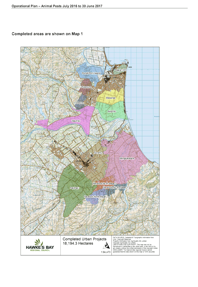
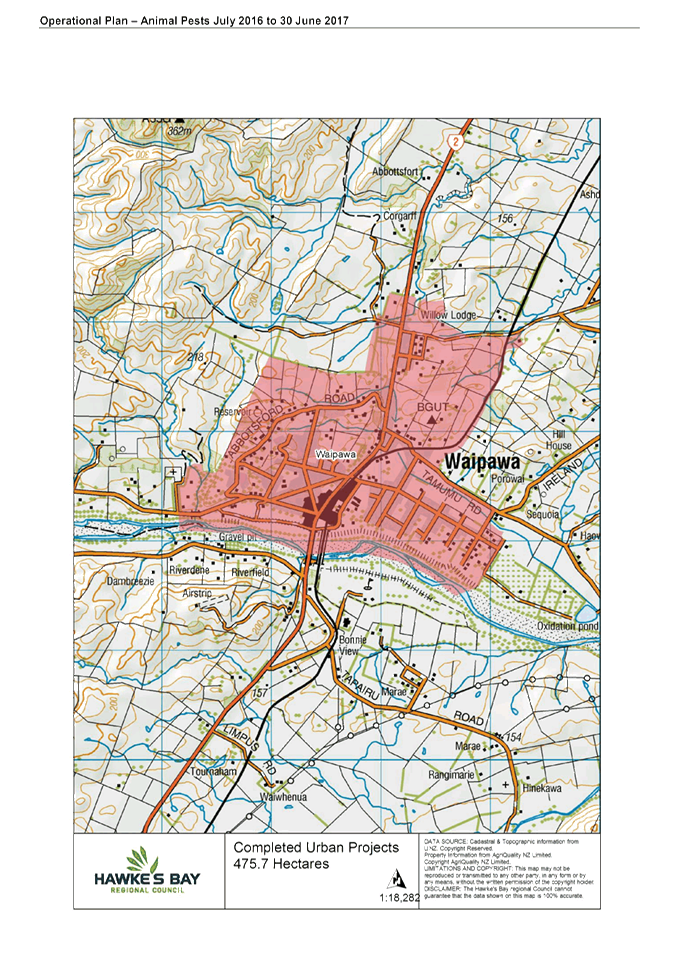

|
Animal
Pest Operational Plan 2016-17
|
Attachment 1
|
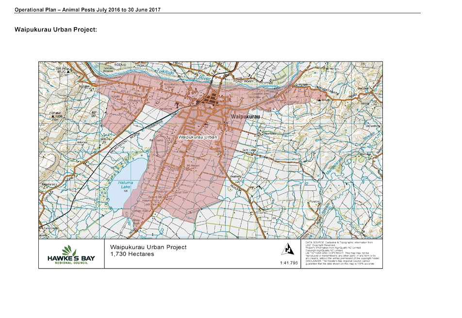
|
Animal
Pest Operational Plan 2016-17
|
Attachment 1
|
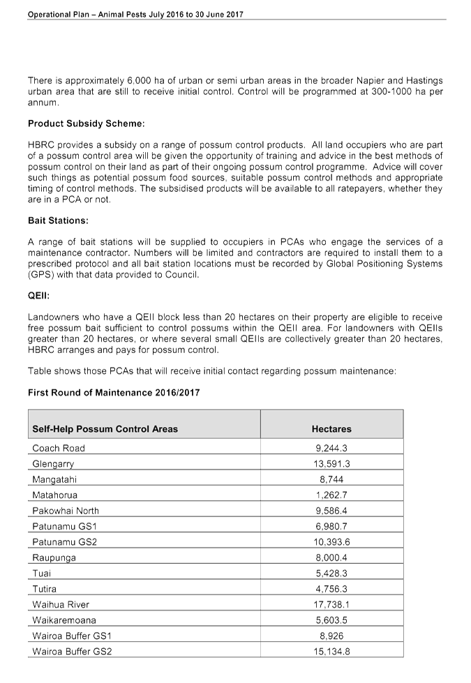
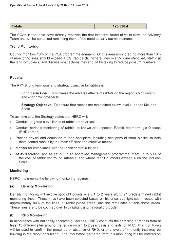
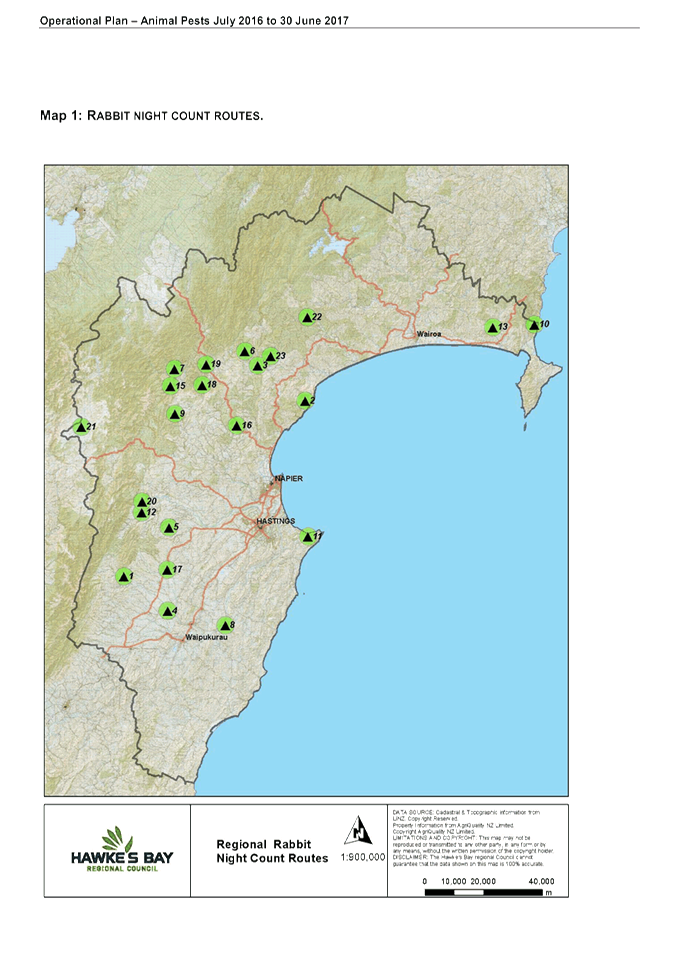
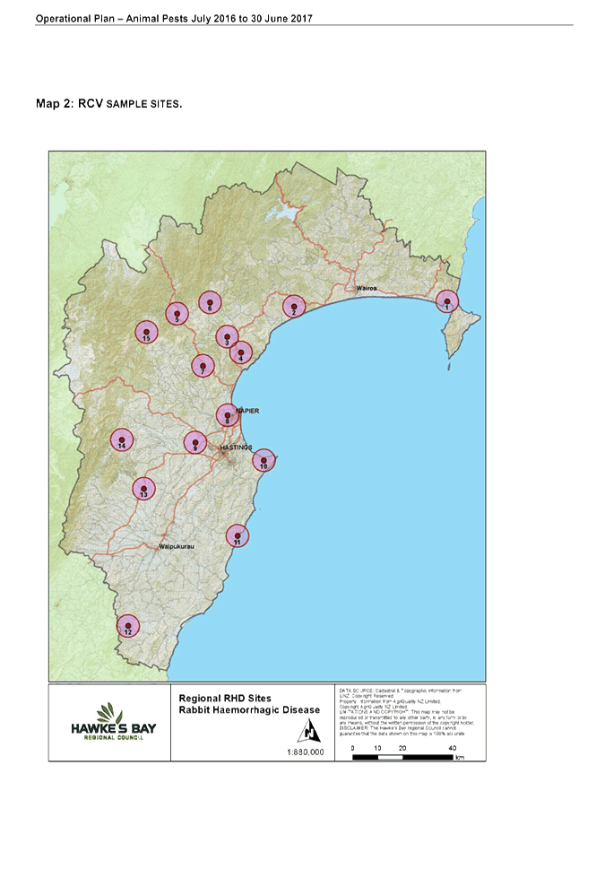
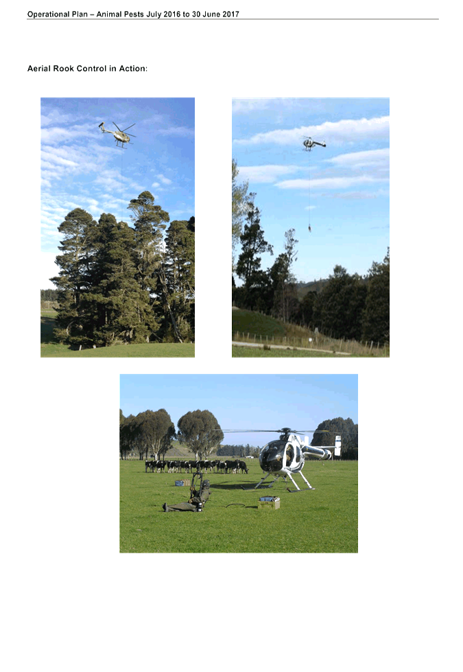
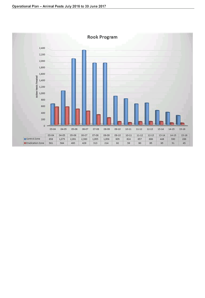
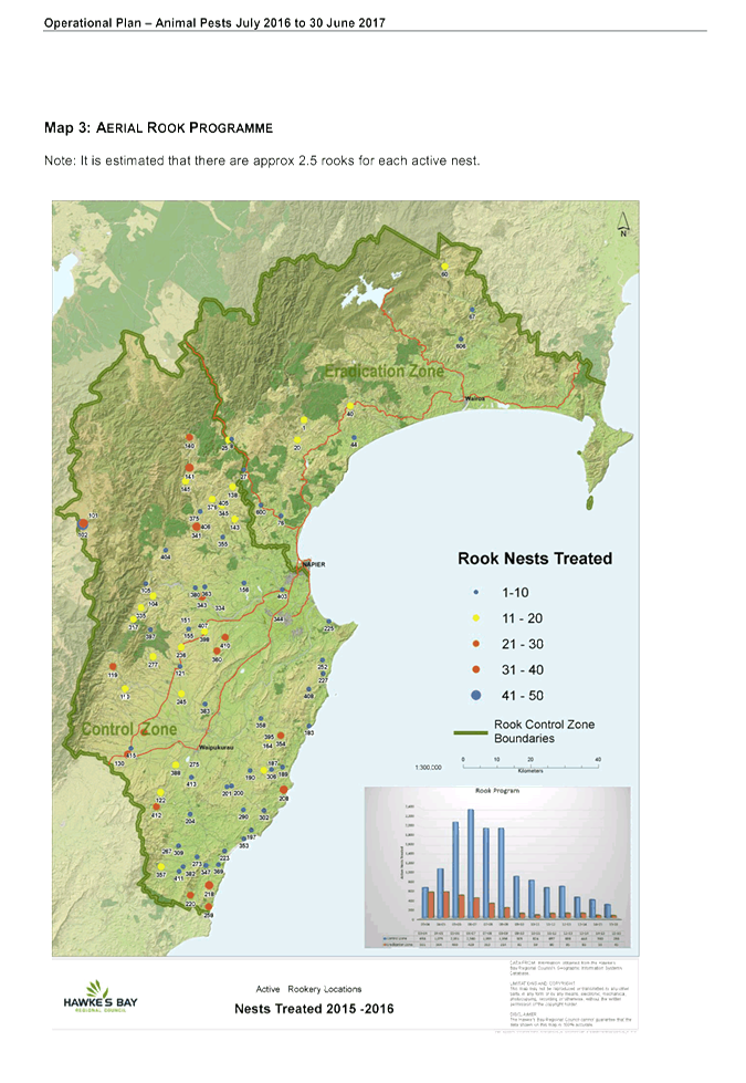
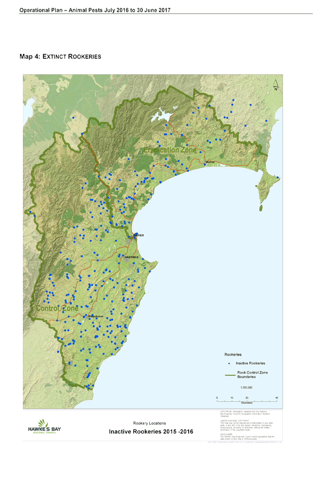

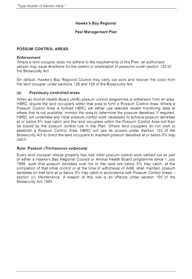
|
Plant
Pest Operational Plan 2016-17
|
Attachment 2
|
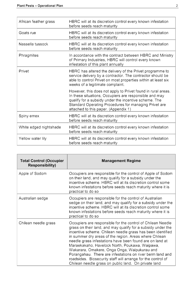
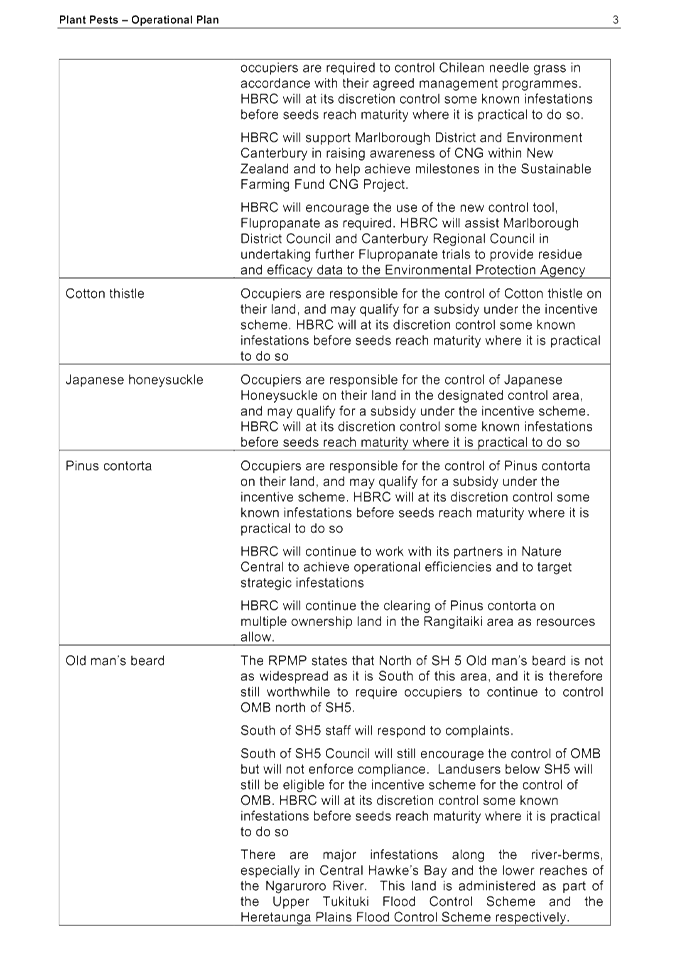
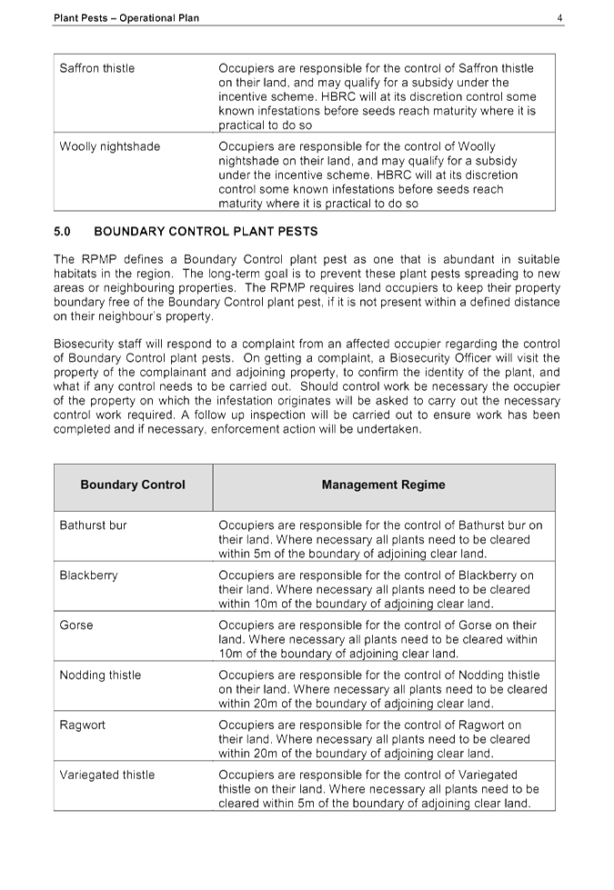
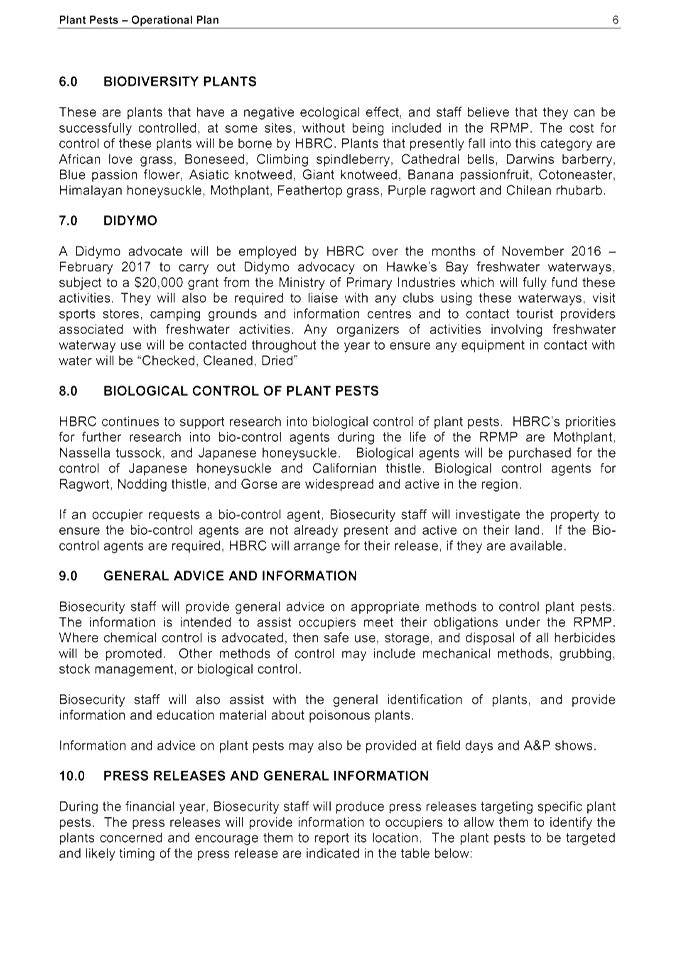
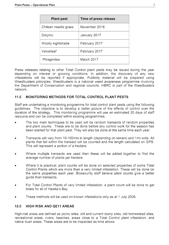
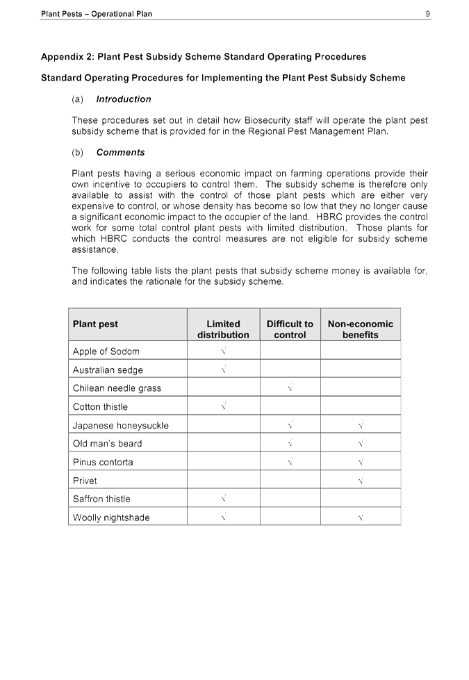
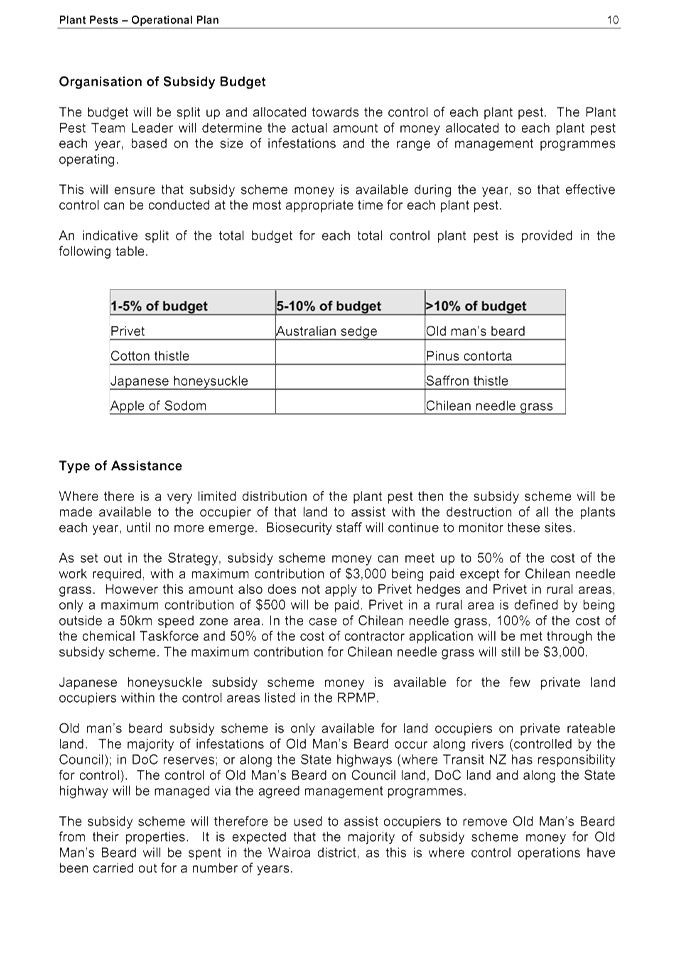

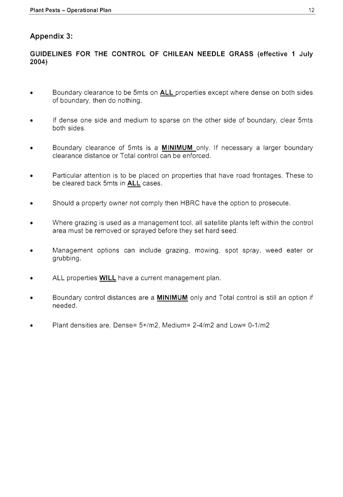
|
Phytosanitary Operational
Plan 2016-17
|
Attachment 3
|

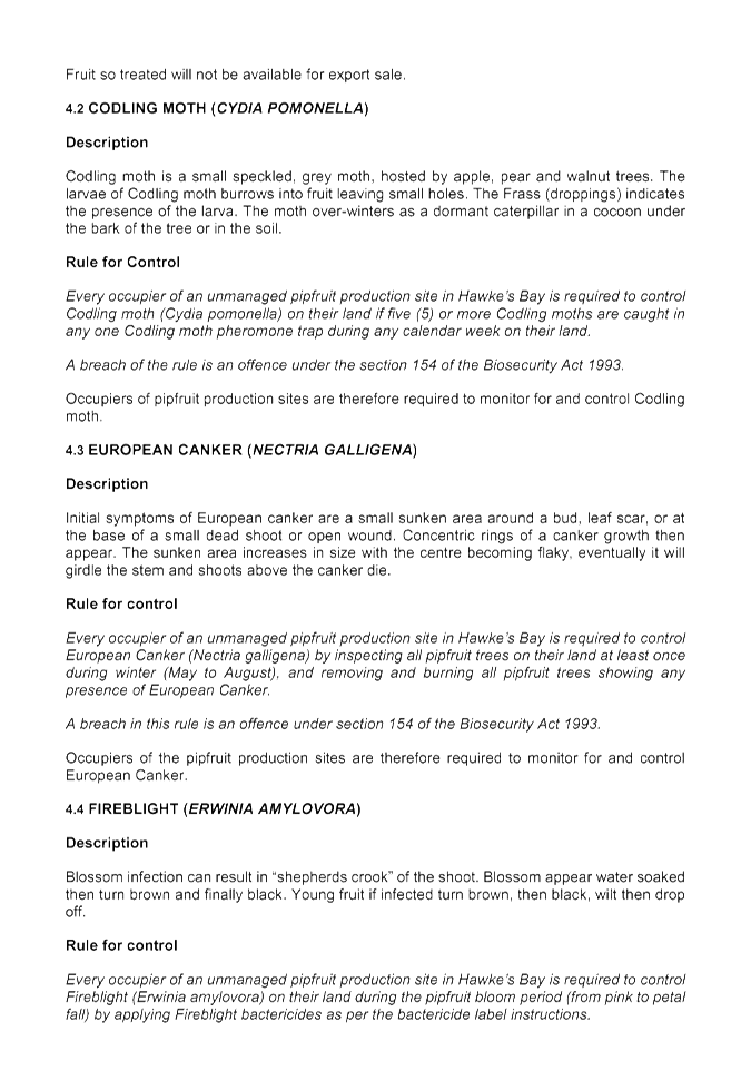
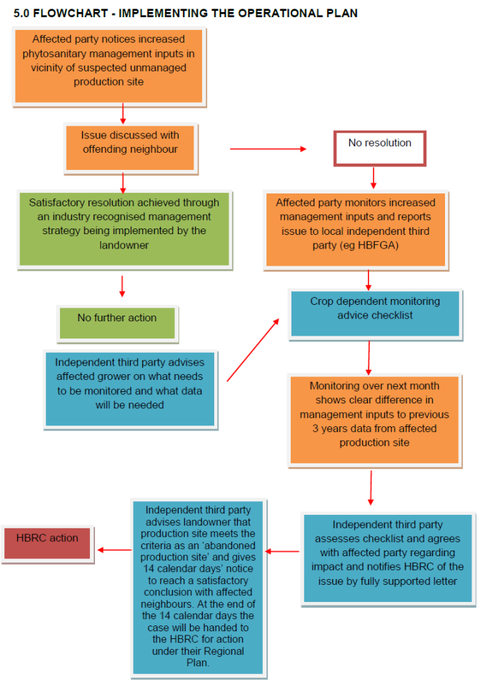
HAWKE’S BAY REGIONAL COUNCIL
Environment
and Services Committee
Wednesday 11 May 2016
Subject: Cape to City Update
Reason for Report
1. The Cape to City project, which along with its sister project
Poutiri Ao o Tane, commenced in early 2015 and will continue over a 5 year
period at a total cost of $6.1 million. In December 2014 Council approved
funding of $1.5m from biosecurity budgets over a five year period for Cape to
City and Poutiri Ao o Tane. Other funders include Aotearoa Foundation,
Landcare Research, Department of Conservation and Cape Sanctuary.
2. The project is potentially transformational both in terms of
biodiversity and community engagement. The two most significant impacts on NZ
and HB’s unique biodiversity are plant and animal pests and loss of
habitat. Part of the project is designed to see if predator control can be
integrated into HBRC’s possum control area programme. If successful it
will act as the large scale predator pest layer that can sit alongside other
HBRC and community biodiversity restoration initiatives such as riparian
planting.
3. Achieving a number of the outcomes in the Hawke’s Bay
Biodiversity Strategy will only be possible if a cost effective way of reducing
the impact of predators on our native fauna and flora can be found and
implemented. This combined with habitat restoration is another key element of
biodiversity recovery.
4. This report updates Council on the Cape to City project.
Campbell Leckie, project manager, for the project, will provide a presentation
to the meeting on the project and the range of items below.
National engagement
and alignment
5. There is significant national interest in Cape to City and Poutiri
Ao o Tane projects. The project manager and members of the project
governance group are working with a number of interested agencies, groups and
individuals. These include the Minister of Conservation, Director General
of the Department of Conservation, key farming industry figures, Local Members
of Parliament, Hastings District Council and Napier City Council, local SPCA,
Zero Invasive Predators (ZIP), the Biological Heritage National Science
Challenge (BHNSC) and Predator Free New Zealand Trust.
Cape to City project
workstreams update
Pest management
6. The pest management workstream includes the full scale field trial
of cost effective widescale predator control (feral cats, mustelids and
hedgehogs) integrated into possum control across 26,000 ha. If successful,
integrated predator control could be considered as part of the Regional Pest
Plan Review which is proposed in mid to late 2017.
7. Initial predator control in Cape to City is underway now in the
first of three control zones. There is strong landowner support for the
programme and significant numbers of predators and in particular feral cats are
being caught.
8. Hastings District Council is providing resources for plant pest
management in key areas of reserves within the project footprint.
9. The pest management workstream is also leading (alongside Taranaki,
Greater Wellington and Horizons regional councils) an initial scoping study
about the application of predator control across multiple regions on two
million hectares of the central and southern north island.
Habitat restoration and
enhancement
10. Significant
habitat restoration and enhancement forms part of the project. The majority of
this is along the riparian margin of the Maraetotara River where historically
HBRC have undertaken significant willow clearance and fencing. This programme
has been done in collaboration with the Maraetotara Tree Trust who have funded
and undertaken planting with land owner support. Fifty thousand native trees
will be planted this winter with the planning proceeding to double that next
winter.
11. An
opportunity is being explored with the honey company Comvita. This opportunity
is considering the possibility of joint investment in high performance Manuka
plantations that will potentially drive multiple economic and environmental
benefits for the region in steeper hill country.
12. A
partnership is developing with the “Trees that Count” project
funded by the Tindall Foundation. Trees that Count will fund some of the 2016
planting project for the Cape to City project. A more detailed update on this
will be provided to Council over the next few months.
13. There are
a number of other restoration opportunities being developed within the project
including working with Waimarama Marae, and the provision of habitat for
whitebait spawning areas.
Research and monitoring
14. There is
a significant commitment to research and monitoring within the project. The
combined research budget for the 15-16 and 16-17 financial years will be $1.5m.
15. Cape to
City has become one of a small number of “partner” projects to the
Biological Heritage National Science Challenge.
16. A
significant amount of applied research is being undertaken including largescale
trap network optimisation, the application of motion sensitive camera
technology, and assessing predator / prey responses such as the risk of rabbit
number increases post predator control.
17. A range
of outcome monitoring programmes are in place including:
17.1 Lizards
and invertebrates including comparing conventional invertebrate monitoring to
soil DNA monitoring
17.2 Birds
including generalist species such as Tui, bellbird and kereru and also rare and
threatened species outflow from Cape Sanctuary
17.3 Whether
the incidence of the disease Toxoplasmosis can be reduced in the wider
landscape through the large scale reduction of feral cats
17.4 Public
engagement surveys for urban and rural residents.
Community engagement /
Education
18. A launch
has been undertaken for landusers within the project at the Waimarama hall.
19. A range
of education programme initiatives with schools and the EIT are underway.
20. A range
of initiatives are underway to build Maori engagement into the project
including representation on the project team, marae meetings and a proposed
larger hui in the next few months.
21. A website http://capetocity.co.nz/ and Facebook page https://www.facebook.com/capetocity
have also been set up to assist with public engagement with the project.
Species restoration
22. The
opportunity to restore a range of species to mainland Hawke’s Bay will be
available if the predator control and habitat enhancement undertaken under the
project is successful.
23. Species
translocations proposed include:
23.1 Tomtits
and robins into the Mohi Reserve on the Maraetotara Plateau within the next 3-4
months
23.2 Kiwi
onto the Maraetotara Plateau farms within the next two years
23.3 Whio
(Blue duck) onto the Maraetotara River within the next 4 years subject to key
resources being secured.
The Project
24. The map
attached as Attachment 1 shows the areas involved in the projects.
Governance
25. The
project governance group is made up of
25.1. Andy
Lowe, land owner including part of Cape Sanctuary
25.2. Bruce
Wills,
25.3. Richard
Gordon, CE Landcare Research
25.4. Tania
Hopmans
25.5. Reg
Kemper from the Department of Conservation
25.6. Mike
Adye
Decision Making
Process
26. Council
is required to make a decision in accordance with the requirements of the Local
Government Act 2002 (the Act). Staff have assessed the requirements contained
in Part 6 Sub Part 1 of the Act in relation to this item and have concluded the
following:
27. The
decision does not significantly alter the service provision or affect a
strategic asset.
28. The use
of the special consultative procedure is not prescribed by legislation.
28.1. The
decision does not fall within the definition of Council’s policy on
significance.
28.2. The
persons affected by this decision are the ratepayers and residents of
Hawke’s Bay.
28.3. Options
have been canvassed as part of the development of the HB draft Biodiversity
Strategy and previous reviews of the Regional Pest Management Strategy.
28.4. The
decision is not inconsistent with an existing policy or plan.
28.5. Given
the nature and significance of the issue to be considered and decided, and also
the persons likely to be affected by, or have an interest in the decisions
made, Council can exercise its discretion and make a decision without
consulting directly with the community or others having an interest in the
decision.
|
Recommendation
1. That the Environment and Services
Committee receives and notes the “Cape to City Update”
report.
|
|
Campbell Leckie
Manager Land Services
|
Mike Adye
Group Manager
Asset Management
|
Attachment/s
|
Cape
to City Map
|
Attachment 1
|

HAWKE’S BAY REGIONAL COUNCIL
Environment
and Services Committee
Wednesday 11 May 2016
Subject: Land Science Update
Reason for Report
1. To update Council on the work currently being carried out by the
Land Science team.
Background
2. The Land Science programme is divided into 2 projects: 339 - Land
Research and Investigations; and 340 - Land Monitoring.
3. Project 339 includes ‘one-off’ programmes of work
involving specific existing catchment issues such as Papanui Catchment nutrient
yield, new research such as riparian zone mapping, and longer term projects
such as S-map, which is the new regional soil mapping programme, and also work
for proposed plan changes and current plan implementation.
4. Project 340 includes State of the Environment (SoE) programmes (soil
quality monitoring) and other long-term monitoring such as wetlands, land use
change, and erosion. In all there are 9 jobs within the 2 projects.
5. Land Science also assists in other HBRC programmes of work,
including Land Management projects, providing technical input to consent
decisions, compliance monitoring and response to compliance matters.
6. A dedicated Land Science team is a recent addition to Environmental
Science at HBRC, being established 6 years ago. Land Science has expanded
recently with the appointment of a Terrestrial Ecologist and the recruitment of
another Land Scientist, bringing the Land Science team to 4 people.
7. The only existing SoE work programme at the moment is the Soil
Quality Monitoring (SQM) programme. The SoE programme is being expanded to
include wetlands, riparian margins and land erosion on both hill country and
plains.
8. The SQM programme currently examines soil quality at 89 sites across
the region that have a range of land uses and soil types. A range of physical,
chemical and biological parameters are monitored at each site, and a report is
produced each year presenting the results from a specific land use.
9. Establishment of the sites commenced in 2010, providing some
baseline information on the state of soil quality. This year the cycle of
monitoring will begin again and the sites will be revisited for the first time.
SoE monitoring is intended to examine trends in environmental conditions, so
the sites will need to be revisited several times before any trends in soil
quality are evident.
10. Recently
interest has been expressed on the effects of molybdenum in soil. Molybdenum is
not an element that is usually lacking in New Zealand soils and is not
considered to be toxic in concentrations usually found in the environment. High
levels of molybdenum in the diet may cause copper deficiency in stock, because
it interferes with animals’ ability to absorb copper, and can cause poor
growth and reproductive problems. Copper deficiency appears to have little
effect on adult sheep, but in ewes can result in lambs being born with bone or
nervous system disorders, causing death within a few weeks of birth.
11. Molybdenum
is not routinely monitored as part of HBRC’s SQM programme and only
Waikato Regional Council currently monitors molybdenum as part of their SQM
programme.
12. Other
large scale projects that are underway at the moment are sediment modelling and
soil mapping of the entire region. The HBRC are leading the way nationally with
our soil mapping (S-map) and sediment modelling (SedNetNZ) projects. Once the
work is completed (2017 SedNetNZ & 2018 S-map), HBRC will be the only
region in the country to be fully covered.
Decision Making
Process
13. Council is required to
make every decision in accordance with Part 6 Sub-Part 1, of the Local
Government Act 2002 (the Act). Staff have assessed the requirements in
relation to this item and have concluded that, as this report is for
information only and no decision is to be made, the decision making provisions
of the Local Government Act 2002 do not apply.
|
Recommendation
1. That the Environment and Services
Committee receives and notes the “Land Science Update”
report.
|
|
Dr Barry Lynch
Principal Scientist / Team Leader - Land
|
Iain Maxwell
Group Manager
Resource Management
|
Attachment/s
There are no
attachments for this report.
HAWKE’S BAY REGIONAL
COUNCIL
Environment
and Services Committee
Wednesday 11 May 2016
SUBJECT: Minor Items Not on the Agenda
Reason
for Report
This document has been prepared to assist Councillors note
the Minor Items Not on the Agenda to be discussed as determined earlier in Agenda Item 6.
|
Item
|
Topic
|
Councillor / Staff
|
|
1.
|
|
|
|
2.
|
|
|
|
3.
|
|
|
|
4.
|
|
|
|
5.
|
|
|