Meeting of the Asset Management and Biosecurity
Committee
Date: Wednesday 9 March 2011
Time: 9.00am
|
Venue:
|
Council Chamber
Hawke's Bay Regional Council
159 Dalton Street
NAPIER
|
Agenda
Item Subject Page
1. Welcome/Notices/Apologies
2. Conflict of Interest Declarations
3. Confirmation of Minutes of
the Asset Management and Biosecurity Committee held on 9 November 2010
4. Matters Arising from Minutes of the Asset Management and
Biosecurity Committee held on 9 November 2010
5. Actions from Asset Management and Biosecurity Committee
meetings
6. Consideration of General Business Items
Decision Items
7. Mahia Community Wastewater Project - Memorandum of
Understanding (MOU)
8. Regional Pest Management Strategy - Discussion Document
Information or Performance Monitoring
9. Multi-Value Assessment of Napier Urban Waterways:
Prioritisation for Enhancement
10. Heretaunga Plains Flood Control Scheme - Rivers: Review
Levels of Service
11. General Business
HAWKE’S BAY REGIONAL COUNCIL
Asset
Management and Biosecurity Committee
Wednesday 09 March 2011
SUBJECT: Actions from Asset Management and
Biosecurity Committee meetings
INTRODUCTION:
1. On the
list attached as Appendix 1 are items raised at Council meetings
that require actions or follow-ups. All action items indicate who is
responsible for each action, when it is expect to be completed and a brief
status comment for each action. Once the items have been completed and
reported to Council they will be removed from the list.
DECISION MAKING PROCESS:
2. Council
is required to make a decision in accordance with Part 6 Sub-Part 1, of the
Local Government Act 2002 (the Act). Staff have assessed the requirements
contained within this section of the Act in relation to this item and have
concluded that as this report is for information only and no decision is
required in terms of the Local Government Act’s provisions, the decision making
procedures set out in the Act do not apply.
|

Mike Adye
Group
Manager Asset Management
|
|
Attachment/s
|
1View
|
Actions from
AMB Meetings
|
|
|
|
Actions from AMB Meetings
|
Attachment 1
|
Actions from Asset Management and Biosecurity
Committee Meetings
The following are a list of items
raised at Asset Management and Biosecurity Committee meetings that require
actions or follow-ups. All action items indicate who is responsible for each
action, when it is expected to be completed and a brief status comment for each
action. Once the items have been completed and reported back to the Committee
they will be removed from the list.
11 November 2010
|
|
Agenda Item
|
Action
|
Person Responsible
|
Due Date
|
Status Comment
|
|
|
5
|
A
question on the existence of a local irrigator’s user group; it is believed
no specific group still exists however this will be checked on and reported
back.
|
MA
|
Feb 2011
|
This informal group was brought
together prior to Council becoming involved in water harvesting projects.
Water User Groups have now superseded this group.
|
|
|
|
|
|
|
|
HAWKE’S BAY REGIONAL COUNCIL
Asset
Management and Biosecurity Committee
Wednesday 09 March 2011
SUBJECT: Mahia Community Wastewater Project -
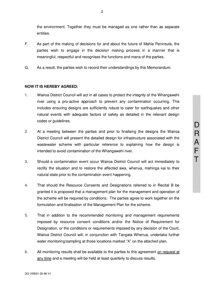
Memorandum of Understanding (MOU)
REASON FOR REPORT:
1. Hawke’s Bay Regional Council and Wairoa
District Council are working collaboratively to establish carbon sequestration
forests and irrigate wastewater onto land.
2. There has been a significant community
engagement process led by Wairoa District Council to gain resource consent and
environment court approval for this project to proceed. The community engagement
process has led to five Mahia linked Marae seeking a Memorandum of
Understanding to be signed with WDC and HBRC. The MOU is to
provide a framework to guide decision making and engagement with regard to the
forestry / wastewater project site and Whangawehi catchment
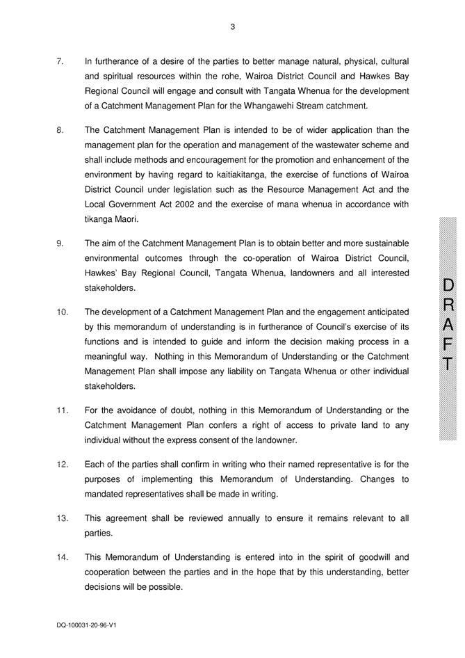
Background
3. The proposed MOU helps provide some
confidence to local Marae that cultural concerns regarding the waste water land
treatment and forestry activities, are being considered and risks appropriately
managed.
4. With the consultation on the wastewater
project local iwi have become resolved to have a more active environmental
guardianship role with regard to the wider Whangawehi catchment that the waste
water treatment facility is located in. They see the development of a wider catchment
management plan as an important tool to achieving this stronger environmental
protection role. Hawkes Bay Regional Council’s principal commitment in the MOU
is to assist the community to develop a wider Whangawehi catchment management
plan.
5. The Marae representatives understand
that Council’s commitment is to provide, where appropriate, staff technical
expertise, time, and facilitate access to other subsidy or incentive resources
that are available. There is no community expectation that resources will
automatically be made available for the catchment management plan, but rather
that Council will endeavour to support the plan with appropriate resources
where possible.
6. Marae representatives would prefer the
MOU to be signed by the Mayor of WDC and the Chair of HBRC as the most senior
representatives of their organisation.
DECISION MAKING PROCESS:
7. Council is required to
make a decision in accordance with Part 6 Sub-Part 1, of the Local Government
Act 2002 (the Act). Staff have assessed the requirements contained within this
section of the Act in relation to this item and have concluded the following:
7.1. Sections 97 and 98 of
the Act do not apply as these relate to decisions that significantly alter the
service provision or affect a strategic asset.
7.2. Sections 83 and 84
covering special consultative procedure do not apply.
7.3. The decision does not
fall within the definition of the Council’s policy on significance.
7.4. The persons affected by
this decision have been involved in the development of the attached Memorandum
of Understanding that is the subject of this report.
7.5. The options have been
considered by the group that has developed the attached Memorandum of
Understanding that is the subject of this report.
7.6. Section 80 of the Act
covering decisions that are inconsistent with an existing policy or plan does
not apply.
7.7. Council
can exercise its discretion under Section 79(1)(a) and 82(3) of the Act and
make a decision on this issue without conferring directly with the community or
others having given due consideration to the nature and significance of the
issue to be considered and decided, and also the persons likely to be effected
by or have an interest in the decisions to be made.
|
RECOMMENDATIONS:
That the
Asset Management and Biosecurity Committee recommend Council:
1. Agrees that the decisions to be made
are not significant under the criteria contained in Council’s adopted policy
on significance and that Council can exercise its discretion under Sections
79(1)(a) and 82(3) of the Local Government Act 2002 and make decisions on
this issue without conferring directly with the community and persons likely
to be affected by or to have an interest in the decision due to the nature and significance of the issue to be considered
and decided.
2. Endorse the signing of the Memorandum of Understanding (MOU)
with the Mahia community marae.
3. Delegate signing authority to the
Council Chairman.
|
|

Campbell Leckie
Biosecurity
Manager
|

Mike Adye
Group
Manager Asset Management
|
Attachment/s
|
1View
|
Memorandum of
Understanding
|
|
|
|
Memorandum of Understanding
|
Attachment 1
|
HAWKE’S BAY REGIONAL COUNCIL
Asset
Management and Biosecurity Committee
Wednesday 09 March 2011
SUBJECT: Regional Pest Management Strategy -
Discussion Document
REASON FOR REPORT:
1. The
Regional Pest Management Strategy (RPMS) is to be reviewed in 2011. At their
meeting in November 2010 the Committee agreed to a
process associated with that review.
2. As an initial stage in
that process the Committee agreed that a discussion document be published
seeking feedback from the community on some of the key issues that have arisen
since the current RPMS was adopted in December 2006.
3. This report presents the
Draft Discussion document for Committee consideration and adoption.
BACKGROUND:
Review
timetable
4. The process and timeframe for the review of the Regional Pest
Management Strategy (RPMS) is as follows:
|
Feb 2011
|
Mar 2011
|
Apr 2011
|
May 2011
|
Aug 2011
|
Aug 2011
|
Sep 2011
|
Nov 2011
|
Dec 2011
|
|
Feb 9 AM&B
Committee
Considers Final
draft of discussion document
|
Regional Pest
Management Strategy discussion document out for public comment
|
Public comment
period for discussion document closes
|
11 May
AM&B
Committee
Considers
submissions on discussion document
|
11 Aug
AM&B
Committee
Considers
proposed reviewed RPMS for public submission
|
RPMS publically
notified for submissions
|
Public
submissions close
|
9 Nov AM&B
Committee
Considers
Completed revised
RPMS
|
Revised Strategy
adopted by Council
|
Dissemination of information
5. Staff propose:
5.1. The discussion document
be circulated in hard copy to key stakeholders under cover of a letter advising
of Council willingness to meet with them to discuss any particular issues or
concerns.
5.2. The discussion document
be posted on Council website
5.3. Press releases be
provided to regional and community newspapers alerting the public to the review
process and the discussion document.
5.4. Public meetings only be
held if a significant number of issues are raised by a particular sector of the
community or a specific issue attracts significant interest.
Governance process
6. The review of the
Regional Pest Management Strategy (RPMS) will require consideration of
submissions on the discussion document as well as consideration of submissions
both written and verbal on the Proposed Reviewed RPMS.
7. Staff suggests the
consideration of submissions could be handled by.
7.1. The full Asset
Management and Biosecurity Committee.
7.2. A subcommittee of the
Asset Management and Biosecurity Committee made up of; the Committee Chair
Councillor Rose, two or three other Councillors, and ex officio the Council
Chairman.
DECISION MAKING PROCESS:
1. Council is required to
make a decision in accordance with Part 6 Sub-Part 1, of the Local Government
Act 2002 (the Act). Staff have assessed the requirements contained within this
section of the Act in relation to this item and have concluded the following:
1.1. The review of the
Regional Pest Management Strategy is required under the Biosecurity Act 1993,
which includes a requirement for public consultation. Accordingly in complying
with the requirements of the Biosecurity Act, Council will be meeting Local
Government Act 2002 requirements.
|
RECOMMENDATIONS
The Asset Management and Biosecurity Committee recommends that
Council:
1. Notes that
in complying with the requirements of the Biosecurity Act 1993, it will meet
the requirements of the Local Government Act 2002.
2. Adopt, subject to any changes agreed by the Committee, the
Discussion document for the Review of Council’s Regional Pest Management
Strategy.
3. Agree that
consideration of submissions on both the Discussion document and the Proposed
Reviewed Regional Pest Management Strategy be handled by:
3.1. Either the full
Asset Management and Biosecurity Committee, or.
3.2. A subcommittee of
the Asset Management and Biosecurity Committee made up of; the Committee
Chair Councillor Rose, two or three other Councillors, and ex officio the
Council Chairman.
|
|

Campbell Leckie
Biosecurity
Manager
|
Mike Adye
Group
Manager Asset Management
|
Attachment/s
|
1View
|
Draft RPMS
Discussion Document
|
|
|
|
Draft RPMS Discussion Document
|
Attachment 1
|
Regional
Pest Management strategy
Discussion Document
Issues for Consideration
March 2011
|
Draft RPMS Discussion Document
|
Attachment 1
|
Table of Contents
·
Purpose.............................................................................................................. 1
·
The
Process...................................................................................................... 2
·
Background...................................................................................................... 2
·
RPMS
Highlights............................................................................................... 2
·
A
Guide to Providing Comment.................................................................... 3
·
Plant
Pests....................................................................................................... 4
·
Privet.................................................................................................................... 4
·
Purple
ragwort..................................................................................................... 4
·
Plant Pest
Accord................................................................................................. 5
· Summary of changes suggested for plant pests................................................... 5
· Key Questions:...................................................................................................... 5
·
Animal
Pests..................................................................................................... 6
·
Possums................................................................................................................ 6
·
Improving
the benefits of the Possum Control Area programme by increasing management of
mustellids and cats................................................................................................. 6
· Key questions:...................................................................................................... 6
·
Focus
of Council’s Biosecurity Programme.......................................... 8
·
Possible
Additional Work Suggested to Council:............................... 8
·
Pest
Pathway Management..................................................................................... 8
· Key Questions....................................................................................................... 8
·
Improved
Surveillance........................................................................................... 8
· Key Questions....................................................................................................... 9
·
Rabbits.................................................................................................................. 9
· Key Questions:...................................................................................................... 9
·
Rooks.................................................................................................................... 9
· Key Questions:.................................................................................................... 10
·
Goats................................................................................................................... 10
· Key Questions..................................................................................................... 10
·
Argentine
Ants..................................................................................................... 10
·
Effective
Long Term Management Options is to:................................................... 11
· Key Questions..................................................................................................... 11
|
Draft RPMS Discussion Document
|
Attachment 1
|
Purpose
The purpose of this discussion document
is to seek initial comment from landowners and other people in Hawke’s Bay on
the best way to continue to manage and control a range of plant and animal
pests. This will assist the Council as it completes its review of the existing
Regional Pest Management Strategy (RPMS). This is a preliminary informal
discussion to gain initial feedback on what is going well, and what
improvements could be made, to enable Council to deliver an efficient and
effective biosecurity service for the benefit of the Hawke's Bay region.
In December
2006 Hawke’s Bay Regional Council adopted the existing RPMS, which sets out a
range of plant and animal pest species, and what Councils role is in
controlling or managing them.
The implementation of the existing Pest
Management Strategy has generally been successful. Success is particularly
notable in the regions possum control area (PCA) programme. Initial control on
all rateable land within the region is programmed to be completed in 2012/2013
3-4 years ahead of 2016, which was Council’s target after the project was
commenced in 2001.
Over the past five years new pest species
such as argentine ants have been responded to. The RPMS review is the
appropriate time to consider if management of additional pests should be more
formally recognised and committed to.
This discussion document sets out those
issues and seeks your comment so that when Council undertakes its formal RPMS
review process the views of affected landowners can be taken into account.
After consideration of comments on this
discussion document Council will formally review its existing Strategy and
publish a new proposed strategy for public consultation in accordance with the
requirements of the Biosecurity Act 1993.
The Process
The process of reviewing the existing
Pest Management Strategy needs to meet the requirements of the Biosecurity Act
1993. You have two opportunities to provide comment to Council on how you
think it is best to manage and control pests in Hawke’s Bay:
· Now by providing comment on the
issues raised in this discussion document. Comment must be provided to the
Council by 8 April 2011; and
· In August / September 2011 by making
a formal submission on the Proposed Revised Pest Management Strategy. (Note
the deadline for formal submissions will be published in the Proposed Revised
Pest Management Strategy).
The expected timeline for
reviewing the Pest Management Strategy and the steps that will be taken are set
out below.
|
February 2011
|
March 2011
|
April 2011
|
May
2011
|
August 2011
|
August 2011
|
September 2011
|
November 2011
|
December 2011
|
|
9 February AM
& B
Committee
Considers final
draft of discussion document
|
Regional Pest
Management Strategy discussion document out for public comment
|
Public comment period for discussion document closes
|
11 May
AM & B
Committee
Considers submissions on discussion document
|
11 August
AM & B
Committee
Considers
proposed reviewed RPMS for public submission
|
RPMS publically notified for submissions
|
Public submissions close
|
9 Nov
AM&B Committee
Considers
Completed revised RPMS
|
Revised Strategy adopted by Council
|
Proposed RPMS Review Timeline
Background
The existing
Regional Pest Management Strategy (RPMS) came into effect in December 2006.
The Biosecurity Act 1993 requires the Council to review its RPMS at least once
every five years, therefore, the Council must undertake a review and publish
that review for public comment before December 2011.
RPMS Highlights
Under the
existing RPMS the Council and landowners are successfully managing or
controlling most of the pests targeted in the Strategy. Key achievements are:
· There are approximately 440,000
hectares of rateable land in Hawke’s Bay now operating as Possum Control Areas
(PCA). Monitoring results over this land show possum numbers to be generally
well below the 5% trap catch objective. (Trap catch is the measure used for
possum densities with 1% equalling 1 possum caught per 100 trap nights under a
specific protocol). PCA initial control is likely to be completed in 2012/2013
3-4 years ahead of schedule. The total area now under control is shown on the
attached map.
· Council’s ground and aerial rook
control programme is well advanced towards achieving the goal of eradicating
rooks north of State Highway 5, and reducing and maintaining numbers below
7,000 birds south of State Highway 5. The number of active nests treated each
year is declining.
· Rabbit monitoring results show that
while rabbit population spikes are occurring, and small-localised areas may
sometimes be above 4 on the Mclean scale, rabbit populations are still not at
pre RHD levels. There are however now generally high immunity levels to the RHD virus in rabbit populations and these are likely to further increase over time.
· Landowners have continued to manage
the plant pests on their land. Council has assisted landowners with some Total
Control plant pests, particularly where the level of infestation of these
plants is low, or where a contractor is the most efficient and effective
service delivery option.
These issues
are discussed in detail in this document, and Council is keen to get your
comment on them.
A Guide to Providing Comment
Hawke’s Bay Regional Council
invites comment on the issues raised in this discussion document from any
person. Comment can be posted, faxed, emailed, or delivered to the Council.
Contact details are:
Postal address:
Hawke’s Bay
Regional Council
Private Bay
6006
NAPIER 4140
Attn: Campbell Leckie
Physical
address: 159 Dalton St, Napier.
Fax:
(06)-835-3601 Attn: Campbell Leckie
E-mail:
pests@hbrc.govt.nz
comment should be provided by Friday 15 April
2011
When
providing comment please provide your full name and address. You may provide
comment on any of the matters covered in this discussion document, and any
other biosecurity issue.
Council would
like to know whether you agree or disagree with the suggested changes and
options covered in this discussion document.
If you think
that changes should be made to the way pests are managed in Hawke’s Bay, it
would greatly assist the Council if you could provide specific comments on what
changes you believe should be made.
After
receiving all the comment, Hawke’s Bay Regional Council will consider comments
received and take account of the comments when it reviews the RPMS. As
required by the Biosecurity Act, the Council will then publish a Proposed
Reviewed Pest Management Strategy and seek formal public submission on it.
A timeline
for the review process is included, under the Process section near the
beginning of this discussion document.
Plant Pests
The RPMS only
includes plants for which the benefit of control outweigh costs, and for which
Council coordinated collective intervention can be justified. The existing Pest
Management Strategy has three categories of plant pests being:
|
Total
Control
(Service
Delivery)
|
Total
Control
(Occupier
Responsibility)
|
Boundary
Control Plant pests
|
|
African
feather grass
|
Apple
of Sodom
|
|
|
Goats
rue
|
Australian
sedge
|
|
|
Nassella
tussock
|
Chilean
needle grass
|
|
|
Phragmites
|
Cotton
thistle
|
|
|
Spiny
emex
|
Japanese honeysuckle
|
|
|
White
edged nightshade
|
Pinus
contorta
|
|
|
Yellow
water lily
|
Old
man’s beard
|
|
|
|
Privet
|
|
|
|
Saffron
thistle
|
|
|
|
Woolly
nightshade
|
|
Council is considering
the following changes:
Privet
Both Chinese
and tree privet cause respiratory illness in some people during their spring
/summer flowering period.
Council had
been managing privet for a number of years as a total control occupier
responsibility plant pest. However a review in 2009 found that this was a very
inefficient way to control privet. Council staff often visited occupiers 4-5
times on one site to get privet removal. In addition auditing by council staff
found that where occupiers were removing privet, at least 50% of removals did
not effectively treat the privet, and it would simply regrow.
For the last
two years staff have been trialling the removal of privet using a council
approved contractor. This has proven to be very successful. The removals are
taking place at a much lower cost allowing more work to be done. In addition
the use of a professional contractor has ensured effective control is achieved.
Council is
proposing to amend the strategy to confirm privet as a Total Control (service
delivery) plant pest in line with the successful trial of the last two years.
Purple ragwort
Purple
ragwort (senecio glastifolius) is an aggressive invader that can become the
dominant cover, displacing more desirable plants. It is an upright perennial
plant that grows up to 1.5m tall and has purple, mauve or pink flowers.
It is
predominant around Te Mata park and the surrounding area. Left uncontrolled in
time it is likely that this plant pest will come to dominate grassland areas in
and around Te Mata park. This will have a visual impact on the park at time of
flowering, and will compete with some of the other flora and biodiversity in
the park. Some control of purple ragwort is carried out by the Te Mata park
Trust Board but there is not a coordinated programme for the plant pest. The
long term potential adverse effects of purple ragwort mean it is very likely to
meet the Biosecurity Act tests for inclusion in the RPMS.
Given the
iconic regional nature of Te Mata park a decision needs to be made whether the
purple ragwort should be controlled in a more coordinated way while it is still
at a relatively low distribution.
The options are:
(1) Continue
with ad hoc control programmes with the likely result that over time purple
ragwort will slowly increase over the park
(2) Make
purple ragwort an occupier responsibility total control plant pest within the
area defined in the following map. Occupiers will be responsible for their own
control and may access a subsidy for control if they use a contractor for
control of purple ragwort within the total control zone. Over time this is
likely to see a reduction in purple ragwort in and around Te Mata park.
Council believes that
these suggested changes better reflect the present situation.
Plant Pest Accord
In addition to the plant pests listed in the Pest Management
Strategy Council will continue to monitor and assist in controlling those
plants listed on the Pest Plant Accord (see http://www.biosecurity.govt.nz/pests-diseases/plants/accord.htmases/plants/accord.htm
for more information on the Pest Plant Accord) and those that have been
declared as unwanted organisms by the Ministry of Agriculture and Forestry.
(The list of unwanted organisms can be found at http://www.biosecurity.govt.nz/commercial-imports/unwanted-organisms-register.
The
Biosecurity Act also provides powers to the Council to undertake small-scale
control work if the presence of harmful plants is observed.
Summary of changes suggested for plant pests
Council is suggesting
that:
(1) The
plant pest privet becomes a service delivery plant pest with control undertaken
by a council approved contractor.
(2) The
plant pest purple ragwort is included in the RPMS as a new plant pest. It would
be included as a Total Control (Occupier responsibility) plant pest
specifically for the Te Mata Park and the surrounding areas.
Key Questions:
(1) Do
you agree / disagree with the proposed changes?
(2) What
additional changes do you think should be made? If the change you are proposing
is likely to increase the cost of delivering Councils plant pest programme,
should that cost be met by removing other plants from the RPMS or by additional
funding ?
Animal Pests
Possums
There are two possum
control programmes operating in Hawke’s Bay at present. These are:
(1). Possum
Control Areas, where the Regional Council undertakes initial possum control and
the landowners are then responsible for the maintenance of low possum numbers
on their land. This work is undertaken in compliance with the existing Pest
Management Strategy. Approximately 60,000 hectares of rateable land still
requires initial possum control. It is likely that this will be completed in
2012/2013.
(2) Animal
Health Board bovine Tb vector control operations as part of the National Pest
Management Strategy for Bovine Tb undertaken by contractors with the aim of
eradicating Bovine tuberculosis (Tb). Council currently manages the programme
in Hawkes Bay with the areas to be treated determined by AHB on the basis of
risk of bovine TB in domestic herds.
There is now
approximately 440,000 hectares of land within Possum Control Areas. Landowners
in Possum Control Areas have been very successful at controlling possums.
Monitoring has shown that landowners are managing, by working together, to keep
possum densities over their land below a 5% trap catch.
The existing Possum Control Area model is working well in Hawke’s
Bay, with a high degree of land occupier support. The benefits of maintaining
low possums numbers are seen as being:
· An increase in pasture production, and therefore stock carrying
capacity, equating to an economic benefit of around $2/ha per annum;
· A significant improvement in the growth of winter fodder crops;
· Biodiversity benefits (seen in extra growth and flowering of trees
and increases in native bird populations);
· A reduction in damage to soil erosion control and amenity plantings;
· A reduction in
damage to forestry plantings.
· A lower risk of Bovine Tb spreading;
Improving the benefits of the Possum Control
Area programme by increasing management of mustellids and cats
The combined possum control area and Animal Health Board programmes
will effectively be over 900,000ha within the next two years. This is a very
large area that is being successfully managed for possum pests with a very
strong level of community support. Combined with new toxins and traps there
is also the potential to grow pest control benefits through the control of
additional pests such as mustellids (stoats, ferrets, weasels) and feral cats.
Currently an integrated wide scale predator control trial is being
undertaken in the Tutira catchment in conjunction with Department of
Conservation and Landcare Research. Councils objectives for this trial are to
establish if wide scale predator (particularly mustellids and cat) control can
be cost effectively achieved and sustained. In addition if it can be achieved
to understand what biodiversity or other community outcomes it contributes to.
Key questions:
(1) Do
you believe council should look to increase the area under active management
for predators? Please explain your reasons why/why not.
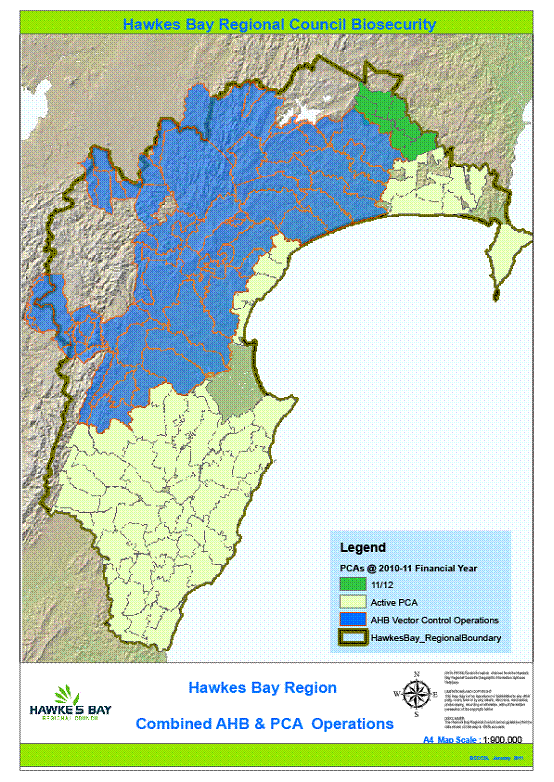
Land covered by possum control areas and the Animal Health Board
programme is shown on the following map.
Figure 1: Possum control operations in Hawke's Bay
Focus of Council’s Biosecurity Programme
The biosecurity programme seeks to protect the Region’s economy and
environment through control of plant and animal pests.
While there are many plant and animal pests that have the potential
to adversely impact the Region’s economy and environment, the Strategy focuses
on those where Council intervention can make a significant difference at an
affordable cost. In many cases the cost is borne by the land occupier on whose
property the pest resides. The Strategy takes into account affordability to
individual land occupiers for management and for control.
Pest management is funded from:
· A targeted rate on each
property over 4ha
· general funding
(general rates and investments)
Council aims to implement the Strategy objectives as efficiently as
possible within the budget.
Key questions:
(1) What
do you think Council should be doing for the management or control of pests in
addition to the current programme of work,
(2)
What do you think Council should not be doing
Possible Additional Work Suggested to
Council:
Pest Pathway Management
Council has traditionally had a focus on the control of pest
species. However there are a range of potential new and existing pests where
the most effective management measure may be through reducing their spread by
managing the pest pathways that they spread through. An example of this is the
movement of pot plant or nursery material which is a key way that argentine
ants spread.
A more proactive involvement in pest pathway management within the
Region might slow the spread of certain pests, and could potentially reduce the
risk of spread from some pests during a new to New Zealand pest incursion.
However intervention by Council to achieve meaningful control may be difficult
and expensive.
Key Questions
(1)
Do you believe Council should consider becoming involved in pest pathway
management within the region? Please explain your reasons why/why not.
(2) If
you believe Council should become involved in this area how could it be done
cost effectively?
Improved Surveillance
MAF Biosecurity New Zealand is the agency responsible for incursion
surveillance for potential new to New Zealand pests. However in some instances
it may be of value to have surveillance in combination with regional industry
for pests that could have significant impacts on Hawke’s Bay, but may not be
the subject of a national surveillance programme.
Key Questions
(1)
Do you believe Council should consider becoming involved in incursion
surveillance? Please explain your reasons why/why not and who should pay.
Rabbits
Council and
its predecessors have a long history of controlling rabbits in Hawke’s Bay.
However, with the spread of Rabbit Haemoraghic disease (RHD) through Hawke’s
Bay in the 1990’s rabbit numbers fell dramatically and have remained below pre RHD levels since. The current Pest Management Strategy took advantage of the effectiveness of RHD, and Council changed its activities from controlling rabbits to monitoring rabbit
populations. Control action is only required if rabbit numbers exceeded a
certain threshold (being 4 on the Mclean Scale). Control is the responsibility
of the landowner but Council will provide advice and subsidise certain control
work. Subsidy is only provided to landowners where they agree to undertake any
ongoing rabbit management programme approved by Council.
Rabbit
monitoring over the last five years indicates that rabbit population spikes are
occurring and small-localised areas are above 4 on the Mclean Scale from time
to time.
Staff currently take a pragmatic interpretation on the management of
rabbits through the RPMS. Where rabbit numbers are high on an individual
property, but are not impacting on neighbours or having soil conservation or
biodiversity impacts on site, then the land user triggers control based on
their willingness to pay 50% of control costs.
Key Questions:
(1) Do
you agree with the current approach to rabbit management within the region?
(2) What
additional suggestions would you make to manage rabbits within the region?
Rooks
The existing
objective for managing rooks is:
From
North of the ‘rook clear line’ destroy all known rookeries by 30 June 2006.
From
South of the ‘rook clear line’ reduce rook numbers to 7,000 birds by 31
December 2004 and maintain rooks, such that numbers do not exceed that amount
in the future.
The “rook
clear line” in the existing Pest Management Strategy is State Highway 5.
Over the last
five years, Council has undertaken a combined ground and aerial rook control
program designed to achieve the objective of eradicating rooks north of SH5 and
reducing and maintaining numbers below 7,000 birds south of SH5.
As well has
controlling known rookeries Council continues to monitor for new rookeries.
The ongoing control programme has meant that 20 of the 54 known rookeries
within the eradication zone are no longer active and bird numbers are
substantially lower across those rookeries that remain. However, Council staff
believe that it will take at least another five to six years of control work
before they will be confident that the last remaining rookeries north of State
Highway 5 have been eradicated. Council is therefore suggesting that this
objective be extended to 2017.
Control work
will also continue south of State highway 5 to continue reducing the number of
rooks in that area.
Key Questions:
(1) What
additional work should Council be doing to ensure rook numbers continue to
reduce in Hawke’s Bay?
Goats
Within the Hawke’s Bay region goats are
an economic resource and a farm management tool. They are also a significant
threat to conservation or biodiversity values, particularly in sites where
conservation values are high. The successful management of goats within the
region requires the careful balancing of these two priorities.
Over the last two years the Hawke’s Bay
Regional Council has led a stakeholder forum with the objective of gaining more
effective long term management of goats in the region.
This forum has shown that more effective
long term management of goats is achievable, but is likely to require more
coordinated management of the risks goats create to biodiversity values at
certain sites.
Key Questions
(1) Do you
believe that Council should resource more effective coordinated management of
goats in conjunction with other stakeholders, and if so how should that be
achieved?
(2) What else
do you believe Council could do to gain more effective long term management of
goats within the region, and who should pay for this work?
Argentine Ants
The
Argentine ant (Linepithema humile) is recognised worldwide as an invasive ant
species. It is native to Argentina and Brazil but is now present in
a number of regions of New Zealand including Hawke’s Bay.
Argentine
ant infestations are frequently not detected until they have reached the stage
of becoming a human nuisance. By the time they have reached this level of
infestation they are well established, impacting on the outdoor lifestyle that
we are accustomed to here in Hawke’s Bay.
Left
unchecked Argentine ants are able to reach very high densities as all Argentine
ant colonies are genetically related. With a lack of in-fighting between
colonies the species is able to form super colonies. Therefore this ant species
can have a significant impact on lifestyle, horticulture and the environment.
They
can also become a serious indoor pest as they often form trails into houses
(especially kitchens) to get the food they require. They are very good at
getting into screw top jars, microwaves and fridges.
The
ability to “hitch” a lift with humans makes the Argentine ant a challenge to
control, especially when Argentine ants produce around ten times more queens
than other species.
Nests found on private land are
the landowner’s responsibility. Hawke’s Bay Regional Council does not carry to
any ant control operations. However Council does provide contact details for contractors
who are able to control the ants professionally and effectively.
Over
the last two years Council has been assessing the extent of the Argentine ant
population in the Region to assist the community in making the most appropriate
long term management response.
Activities Council has been
involved in are:
· Monitoring
to establish the extent of the Argentine ant population in the Region
· Working
with local pest contractors to ensure best practise control is undertaken
· Working
with communities who have Argentine ants to ensure they understand best practise
control and to facilitate communities forming Argentine ant community control
groups
· Engaging
recognised New Zealand Argentine ant specialists to help develop long term
management strategies
· Reviewing
other regions who have Argentine ant control programmes to understand what has
been successful and what lessons have been learned in those regions for
Argentine ant management.
· Undertaking
research both at a coordinated national level into more effective control tools
and at a regional level into how the community perceives Argentine ants and the
risks they pose.
· Working
with other agencies such as Port of Napier, Napier City Council and Hastings
District Council to assist agencies to coordinate control on their land in
support of community baiting initiatives.
There are currently over 2500
properties in Hawke’s Bay across more than a dozen sites where Argentine ants
have been identified. Experts engaged to review the Hawke’s bay Argentine ant
management options and the experience of other regions agree eradication is not
an option.
Effective Long Term Management Options is to:
Focus on the current programme of
monitoring, best practise control education, facilitating community control
groups where there is sufficient interest in the community, and supporting
national research into more effective control tools.
Key Questions
(1) Do you believe Council should support longer term
management of Argentine ants within the Region?
(2) What other initiatives do you believe Council
could undertake to achieve effective management of Argentine ants?
HAWKE’S BAY REGIONAL COUNCIL
Asset
Management and Biosecurity Committee
Wednesday 09 March 2011
SUBJECT: Multi-Value Assessment of Napier
Urban Waterways: Prioritisation for Enhancement
REASON FOR REPORT:
1. This report is to
inform the Asset Management Biosecurity Committee on a recently completed
report on multi-value assessment of the Napier urban waterways. This work was
part of the HPFCS Drainage projects in 2009/10 (Project 290 and 291). The report
is entitled “Multi-Value Assessment of Napier Urban Waterways: Prioritisation
for Enhancement, February 2011”.
Background
2. The project is about
determining a methodology for assessing, valuing and ranking the Napier urban
streams according to their current and potential ecological, recreational,
health and safety, cultural, landscape and drainage values. The methodology is
applicable to locations other than just Napier.
3. This committee has
previously been given a presentation on the Stream Ecological Valuation method
(SEV) developed for aquatic ecology. Because of the success of the SEV
methodology and the wide acceptance of its use, a similar procedure has been
developed for the other stream values.
4. Council has adopted a
multi-value approach for managing the waterways in scheme areas. However it is
quite difficult and complex to assess and rank these values without some form
of measurement methodology. One method is to attribute dollar values to such
values. For example, benefit / cost analyses for roading projects may include
the dollar cost of a life, injury, travel time etc. and these costs form part
of the evaluation process. The Multi-Value Assessment method (MVA) assesses and
ranks the values using a scoring system based on assessment criteria, and
economic decisions on how and where to proceed then follow.
5. In effect, once the
assessment has been carried out the streams have a benchmark reflecting their
current values. When any enhancement work is proposed its relative value can be
assessed and decisions can be made to carry out, or not, as appropriate. Later
this work can be reassessed and a measure of the improvements gained. This can
then provide a meaningful measure of the Level of Service (LOS) achieved
through enhancement.
Methodology
6. MWH New Zealand Ltd
prepared the report (Adam Forbes and Dave Compton-Moen) using their expertise
in the areas of ecology, landscape, recreation and health and safety. HBRC
provided expertise in drainage and culture. The cultural assessment was guided
by Jenny Mauger based in part on the Cultural Health Index work; approval and
field work was carried out by (Heitia Hiha and Arapera Riki for Mana Ahuriri
Inc.).
7. As well as the chosen
experts in their fields applying the methodology, a small number of
consultation interviews were held with members of the public that use the
network. This information was used to gauge the public perception and use of
the network and assist with the values assessments and weighting.
8. On completion of the
field data collection and assessment a workshop was held between the experts
and others chosen for their abilities to provide an audit and advice role. This
workshop reviewed the data, the values and assessment criteria. A review was
also carried out on the enhancement actions, the ranking of reaches and the MVA
assessment tool. Now that the tool has been developed, a workshop would not be
a necessary part of any future MVA assessment for other streams.
9. Each stream was divided
into reaches based around the reaches used in the SEV study, for ease of
reference. In total five Napier streams were evaluated. These were:
9.1. Old Tutaekuri
Riverbed (OTR) (3 reaches)
9.2. Taipo (5 reaches)
9.3. Purimu (3 reaches)
9.4. County (4 reaches)
9.5. Plantation (3
reaches)
Results
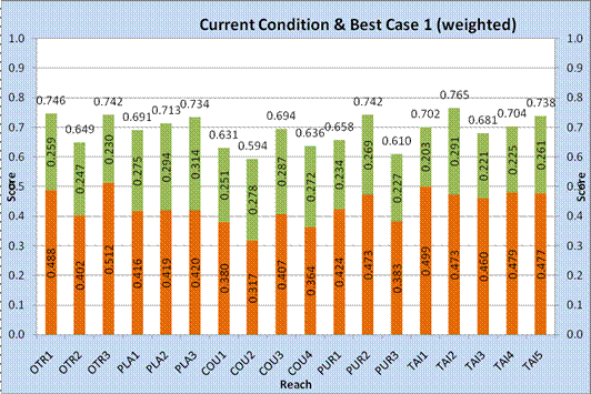
10. The field assessments of
current condition and enhancement gains are scored on a scale of 1 to 20. The
results are normalised to a scale of 0 to 1 with 1 being the highest (or best)
score. The current condition scores ranged from 0.32 to 0.51. The enhancement
gain scores ranged from 0.2 to 0.31 and not in the same order as the current
condition scores.
1.
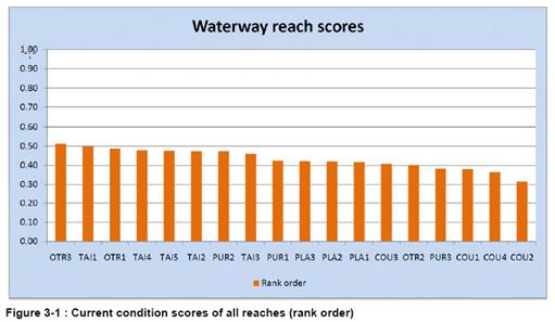
11. Although all the stream
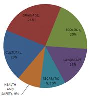
values are assessed on an equal basis, there is a need to weight the values to
ensure that the primary functions are not overwhelmed by the secondary
functions. For these streams Drainage is the primary function, there is no
getting away from that fact. Ecology and Culture are weighted equally just
behind Drainage; with Landscape, Recreation and Health and Safety following in
order. The pie graph below shows the breakdown of these weightings.
2.
3.
These weightings were assessed by the panel of
experts as being appropriate for the Napier streams in the survey. The
methodology scoring spreadsheet can accommodate any combination of weighting to
suit a particular stream’s primary purpose.
12. To demonstrate the value
of the MVA it is interesting to look in detail at each site. For example the
highest current condition score was site OTR3 (which is the waterway alongside
Georges Drive). The interesting thing about the score is that it scored highest
for recreation and landscape and high for health and safety. On the other hand
the ecology and cultural values were low.
13. Another example is the
OTR2 reach (middle reaches of the OTR) which scored notably lower than its
adjoining upper and lower reaches due to its lower health and safety,
recreational and landscape values yet it had high ecology and drainage values.

Enhancement Gains
14. All three Plantation
waterway reaches featured in the six largest gain scores with PLA3 showing the
greatest potential of all 18 reaches. PLA3 is the reach that is in this year’s
annual plan for enhancement. (Work is due to begin at the beginning of March
2011). The figure below shows the enhancement gains for the reaches examined.
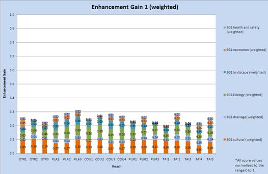
15. Of the five highest
scoring (enhancement) reaches, terrestrial ecology and cultural values stand
out as consistently contributing most to enhancement gain scores. These reaches
are shown circled in the figure below.
Discussion
16. The Multi Value
Assessment (MVA) method highlights both Higher Value Reaches that should be
protected and Lower Value Reaches that have good enhancement potential. This is
an important distinction as the approach to achieving good outcomes will be
different.
17. The report identifies
and recommends sites that should be the focus of ‘protection’ management
options. For example:
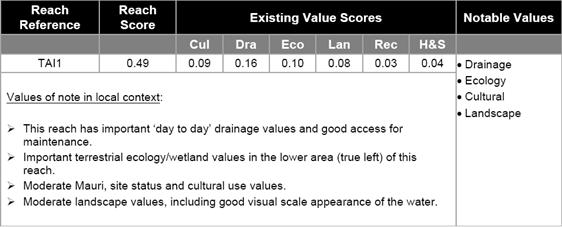
18. The current Lower Value
Reaches with good enhancement potential have all been prioritised as per the
table below.
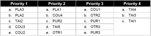
19. The Multi-Value analysis
provides the information for each of the priority groups about which particular
value is downgraded and will benefit the most from appropriate enhancement
works. It is interesting to note that the value areas of Culture (all
criteria), Landscape (naturalness of waterway), Ecology (wildlife corridors),
and Recreation (public access to the water) are all strong themes for
enhancement.
DECISION MAKING
PROCESS:
20. Council is required to
make a decision in accordance with Part 6 Sub-Part 1, of the Local Government
Act 2002 (the Act). Staff have assessed the requirements contained within this
section of the Act in relation to this item and have concluded that, as this
report is for information only and no decision is to be made, the decision
making provisions of the Local Government Act 2002 do not apply.
|
RECOMMENDATION:
1. That the Asset Management and Biosecurity Committee recommend that Council
receives the report.
|
|

Gary Clode
Manager
Engineering
|

Mike Adye
Group
Manager Asset Management
|
Attachment/s
There are no
attachments for this report.
HAWKE’S BAY REGIONAL COUNCIL
Asset
Management and Biosecurity Committee
Wednesday 09 March 2011
SUBJECT: Heretaunga Plains Flood Control
Scheme - Rivers: Review Levels of Service
REASON FOR REPORT:
1. Council manages and
administers the Heretaunga Plains Flood Control Scheme to maintain an effective
flood control network that provides protection from frequent river flooding to
communities and productive land on the Heretaunga Plains.
2. Flood protection is
provided through river control works, stopbanking, and a network of drainage
waterways and pumping stations.
3. Council has committed,
through the 2009-2019 LTP, to review the current levels of service provided by
the Heretaunga Plains Scheme, to determine whether they are still appropriate
or should be increased.
4. Council approved the
project plan to guide the level of service review in May 2010. The review is
scheduled for completion in 2011.
5. The purpose of this
paper is to inform the Committee of progress made to-date in reviewing the
levels of service for the Heretaunga Plains Scheme – Rivers.
Background
6. The attached progress
report sets out:
6.1. A brief overview of
the key factors driving the level of service review;
6.2. A summary of the
steps and timeframes required to complete the review; and,
6.3. The findings of two
key studies undertaken to support the review (economic analysis and regulatory
planning assessment).
Investigations
7. An economic analysis
was carried out by Sean Bevin of Economic Solutions Ltd in Napier, in August
2010. The study analysed:
7.1. The current profile
and level of demographic, economic and investment activity in the Heretaunga
Plains area protected by the Heretaunga Plains Flood Control Scheme;
7.2. The main economic
changes that have occurred in the area over the past 20 years;
7.3. The main economic
trends and changes forecast for the area over the longer-term;
7.4. The local and
regional economic impacts of a significant failure(s) of the present flood
control scheme;
7.5. The implications of
the above analysis for the future level of flood protection provided by the
Scheme; and,
7.6. The appropriateness
of the current benefit allocation approach used by HBRC for funding the costs
of operating and maintaining the Scheme.
8. A regulatory planning
assessment was completed by Gavin Ide, HBRC Team Leader Policy, in December
2010. The assessment supported two investigation outcomes;
8.1. A review of current
and proposed planning provisions with respect to the level of protection
provided to flood control assets in the Scheme, and any changes in land use
intensification/use that they promote; and,
8.2. Identification of
opportunities to restrict development in strategic areas adjoining flood
protection assets in order to manage for super design flood events; and, where
suitable areas of land for protection are identified, the processes available
to ensure that these areas are protected from inappropriate subdivision, use and
development.
9. These assessments,
along with the hydrodynamic modelling currently underway, will inform
development and consideration of a range of options for improving the Scheme
levels of service.
DECISION MAKING
PROCESS:
Council is required to
make a decision in accordance with Part 6 Sub-Part 1, of the Local Government
Act 2002 (the Act). Staff have assessed the requirements contained within this
section of the Act in relation to this item and have concluded that, as this
report is for information only and no decision is to be made, the decision
making provisions of the Local Government Act 2002 do not apply.
|
RECOMMENDATION:
1. That the Asset Management and Biosecurity Committee recommends that
Council receives the report.
|
|

Larissa Coubrough
Asset
Engineer
|

Gary Clode
Manager
Engineering
|
|

Mike Adye
Group
Manager Asset Management
|
|
Attachment/s
|
1View
|
Project
Update
|
|
|
|
2View
|
Map Roys Hill
Scenario
|
|
|
|
3View
|
Map Taradale
Scenario
|
|
|
|
4View
|
Map Moteo
Scenario
|
|
|
|
Project Update
|
Attachment 1
|
HERETAUNGA PLAINS FLOOD CONTROL
SCHEME – RIVERS LEVEL OF SERVICE REVIEW
PROJECT UPDATE
February 2011
1.0 PURPOSE
This report
provides a summary of progress made to-date with respect to the Heretaunga
Plains Flood Control Scheme (HPFCS) - Rivers Level of Service (LOS) Review.
The findings of two key studies undertaken to support the review; the Economic
Analysis and the Regulatory Planning Assessment, are detailed.
Section 4.0
sets out next steps in terms of advancing the project to completion.
2.0 BACKGROUND
Council
committed, through the 2009-2019 LTP, to “review the current flood control
levels of service provided by the Scheme to determine whether they are still
appropriate or should be increased.” The LTP Performance Targets provide for
project completion by 2012.
The review
is being driven by a number of factors, including:
· Community
feedback associated with a public survey undertaken in 2008, which identified
‘flooding hazard’ to be in the top three most important threats in Hawke’s
Bay. The survey also found that the community would like greater resources
allocated to address this;
· The
Council’s decision in 2007 to adopt a new multi-value approach to waterway
management. This new approach seeks to protect and enhance the cultural,
heritage, landscape, drainage, recreation, and ecological values of Council
owned and administered watercourses;
· Land
use and regulatory change. The most recent upgrade of the flood control scheme
was undertaken more than 20 years ago when land use on the Plains was less
intensive and land values much lower than they are today. These factors, in
conjunction with the recent completion of the Heretaunga Plains Urban
Development Strategy (HPUDS), suggest the need to re-evaluate the level of
protection that is and should be provided so that the levels of service better
align with the needs of current and future generations; and,
· Anticipated
projections of climate change in Hawke’s Bay, which suggests lower total
rainfall but more frequent, more intense, rain events in future. Seasonal
changes are also anticipated with lower rainfall in winter and spring and
greater rainfall in summer and autumn. Greater intensity events are likely to
result in an increased frequency of flooding. Climate change predictions need
to be carefully considered in order to determine whether a greater level of
protection is required to protect against changing weather patterns.
Council’s
Asset Management and Biosecurity Committee approved a project brief to guide
the LOS review at their meeting in May 2010. The project restricts
consideration to the major rivers and their associated flood control works; it
was agreed that drainage would be considered separately due to the differing
nature of issues associated with the HPFCS drainage network. A project brief
for this secondary assessment will be developed shortly.
The LOS
review closely aligns with a number of other projects also currently underway,
including; the HPFCS Asset Management Plan review; the Environmental Code of
Practice review; the gravel management review; and, development of the
Ngaruroro and Tutaekuri Ecological Management and Enhancement Plans.
Consideration will be given to the implications that the LOS review may have on
these other policies and processes currently under development.
Key
components of the project and their agreed timeframes for completion are as
follows:
|
1. Review established levels of
service
|
June-July
2010
|
|
2. Complete economic analysis
|
August
2010
|
|
3. Review existing/proposed
regulatory planning instruments
|
November
2010
|
|
4. Model flood scenarios (incl.
climate change) and develop options
|
March
2011
|
|
5. Discuss options with TLAs in
terms of the strategic planning process
|
March
2011
|
|
6. Complete cost/benefit
analysis
|
April
2011
|
|
7. Circulate options paper to
AMB Committee
|
May 2011
|
|
8. Seek public feedback on
options
|
May-June
2011
|
|
9. Circulate summary report to
AMB Committee
|
August
2011
|
|
10. Implement agreed changes
|
August
2011
|
3.0 PROGRESS
AND STUDY FINDINGS
The LOS
review is progressing as scheduled with the hydrodynamic modelling and option
development currently underway. The economic analysis and regulatory planning
assessment were completed in 2010 and will also inform the development and
consideration of options. The following sections summarise the outcomes of the
two key studies completed to-date:
3.1.1 Economic Analysis
Sean Bevin,
an Economic Analyst at Economic Solutions Ltd, Napier, was commissioned in
August 2010 to complete an economic analysis of the Heretaunga Plains Flood
Control Scheme. The analysis required assessment of:
· The
current profile and level of demographic, economic and investment activity in
the Heretaunga Plains area protected by the HPFCS;
· The
main economic changes that have occurred within the area over the past 20
years;
· The
main economic trends and changes forecast for the area over the longer-term;
· The
local and regional economic impacts of a significant failure(s) of the present
flood control scheme;
· The
implications of the above analysis for the future level of flood protection
provided by the HPFCS; and,
· The
appropriateness of the current benefit allocation approach used by HBRC for
funding the costs of operating and maintaining the HPFCS.
Information
to complete the analysis was sourced from Statistics NZ, Food and Crop
Research, NZ Institute of Economic Research, Ministry of Agriculture and
Forestry (Hastings Office), and Dr Warren Hughes, Honorary Fellow at the
University of Waikato’s Department of Economics. Council’s rating information
and flood hazard maps were used to identify directly and indirectly affected
properties within the Scheme area.
The study
concluded that:
· There
has been a significant increase since 1991, in the demographic base of the
HPFCS catchment, with the total population increasing by 12% and household
numbers by 20%.
The
current resident population of the total catchment area for the HPFCS is approximately
127,000; representing approximately 96% of the combined population of the
Napier/Hastings districts and 82% of the total Hawke’s Bay region population.
Approximately 55,000 people live within the directly floodable or impacted area
of the catchment and 72,000 live within the indirectly affected area.
· Over
the past decade, the catchment economy has grown by approximately one-third,
accompanied by a significant degree of production diversification and change.
The
total number of businesses operating in 2009 in the HPFCS catchment stood at
approximately 13,700, representing over 90% of the combined Napier-Hastings
district’s total and 74% of the Hawke’s Bay regional total. Primary production
and related processing accounts for 18.4% of all business in the area, with
pastoral farming and fruit growing leading the sector. Manufacturing activity
accounts for 3.4% of total businesses and the services sector 78.2%.
· The
HPFCS catchment is the ‘engine room’ of the Hawke’s Bay economy, comprising the
majority part of the Hawke’s Bay primary production/processing and related
servicing base. The Heretaunga Plains is an important contributor to the
national fruit and horticultural sector.
Total
annual sales from the primary production, processing, manufacturing, and
service sector enterprises located in the HPFCS area are currently estimated at
$15.5 billion (83% of the regional total). The primary production sector accounts
for 19% of total catchment area sales; processing/manufacturing 20%; and the
broad services sector the balance of 61%.
Primary
production activities in the catchment accounts for 70% of total sales for the
sector at the regional level, with the processing/manufacturing sector
accounting for 75% of regional sales for this sector, and the services sector
accounting for 91% of regional sales for this sector. The directly impacted
area for the HPFCS accounts for 57% of the total catchment area industry sales
and the indirectly impacted catchment 43%.
The
leading fruit and horticultural growing industries in the catchment area
include; pip-fruit (4,524ha and 24.5% of total production area), wine grapes
(4,709ha and 25.7%), and outdoor vegetables (7,513ha and 41.0%). Together they
account for in excess of 90% of the total production area.
· The
area of the total HPFCS catchment that would be directly impacted by a major
flood event is a key and growing part of the total catchment economy.
On
the basis of the current annual GDP estimate for the Hawke’s Bay region, total
catchment area industry sales, and the catchment’s share of total regional
employment, GDP for the total catchment is currently estimated at $5.2 billion.
In
2009, total employment in the HPFCS area stood at 65,024, comprising 54% in the
direct catchment and 46% in the indirect catchment. The total for both
catchments represents 97% of overall employment in the combined Napier/Hastings
districts and 85% of total Hawke’s Bay-wide employment. Within the total
catchment, the primary production sector accounts for 15% of all industry
employment, processing/manufacturing 12%, and services 73%.
Regional
rating information indicates a total current underlying land valuation in the
area of $10.1 billion, comprising 71% in the directly floodable part of the
catchment and the residual 29% in the indirectly impacted part. The
residential sector component of the total valuation is estimated at $6.1
billion (60%). The total catchment capital valuation is approximately $20.5
billion, with 85% comprising the directly floodable area and the balance of 15%
comprising the indirectly impacted area.
· Further
significant demographic, economic, rural production and other industry growth
is forecast for the catchment area over the longer-term. Demographic growth is
also forecast to be higher in the directly floodable part of the catchment.
Using
the HPUDS projections as a base, the resident population of the HPFCS total
catchment area is projected to increase from the current estimate of 127,000 to
139,000 by Year 2045; equating to a gain of 12,000 or 9.4%. The population of
the directly floodable part of the catchment is projected to increase by 18%
and the population of the indirectly impacted part by around 3%. In 2045, the
directly affected area will account for approximately 45% of the total
catchment population and the indirect area 55%.
The
number of households in the total HPFCS catchment is projected to increase by
approximately 11,390 (22.4%) over the period 2010-2045. The number of
households in the direct catchment is projected to increase by 5,156 (25%) over
this period and account for approximately 41% of all households in the total
catchment by 2045. The number of households in the indirectly affected area is
projected to increase by 6,233 (21%).
Overall,
real average annual economic growth of 2% is forecast for the Napier-Hastings
area over the period 2010-2045. The most significant growth over the next
decade is forecast for agriculture, health and community services, machinery
and equipment manufacturing, business services, forest products processing and
manufacturing, Central Government administration, tourism/hospitality services,
transport/storage services, communication, construction, and wholesale/retail.
The industry sector is forecast to grow over the 2010-2045 period at an annual
rate of approximately 3%.
· Major
flooding within the HPFCS catchment has the potential to result in a very
significant economic impact loss for the local and regional economies.
Economic
impact assessments were carried out for three stop bank breach scenarios: a
breach at Roys Hill; Taradale; and Moteo. These scenarios were chosen as being
representative of a large-scale flooding event, as well as a smaller urban and
smaller rural event. The resulting floodable areas used for the exercise were
sourced from Council’s ‘Flood Hazard Study’, June 1999 (refer to maps attached)
and considered in conjunction with regional economic profile and trend information.
Table
1 presents the total direct and backward linkage economic impact for Hawke’s
Bay associated with a stop bank breach at Roys Hill, Taradale, or Moteo.
Table 1:
Total Regional Economic Impact Losses
|
Economic Impact Measure
|
Total Multiplied Economic Impact
Losses
|
|
Roys Hill Breach
|
Taradale Breach
|
Moteo Breach
|
|
Net Household Income ($M)
|
182.0
|
135.7
|
9.9
|
|
Total Employment
|
6,040
|
4,124
|
365
|
|
GDP
|
385.5
|
277.2
|
21.7
|
Net
Household Income refers to the additional income accruing to households in the
local economy, net of taxation and various forms of saving. Total Employment
refers to total full and part-time persons engaged in work on an annual basis.
GDP refers to the total value of additional economic activity generated within
a particular local economy, after removing the value of imported goods and
services. In this case of production losses, these measures need to be viewed
from the opposite point of view. For example, GDP will refer to the total loss
in economic activity in the region following the direct production losses
generated by the flooding.
The
economic impacts in Table 1 include both the direct and indirect/induced
multiplier, or flow-on, impacts. Direct impacts refer to ‘first round’ revenue
or spending impacts. Indirect impacts refer to impacts on supplier or backward
linked industries. Induced impacts refer to the flow-on household consumption
spending impacts.
Backward
linkage impacts refer to the adverse impacts (of the production losses) on
those industries supplying various production inputs to the industries directly
affected by the flooding. In the case of the Roys Hill flooding scenario, the
total GDP impact indicated comprises a direct impact of $186.8 million and a
backward linkage/supplier impact of $198.7 million.
The forward
linkage economic impact losses within the region refers to the impact of the
flooding on forward linked industries such as food processing, wholesaling and
retailing, and construction etc. that utilise the outputs from the directly
affected industries. In the Roys Hill case, the total forward linked GDP
impact loss in the region is $140.5 million. The estimated forward linked
impact losses for the other two areas are; Taradale $40 million, and Moteo $10
million.
Table 2
summarises the direct, backward linked, and forward linked economic impact
losses for the three flooding/stop bank breach scenarios.
Table 2:
Napier-Hastings Major Flood Event Economic Impact Total GDP/Value Added Losses
|
Economic
Impact
|
Economic Impact Losses ($M)
|
|
Roys Hill Breach
|
Taradale Breach
|
Moteo Breach
|
|
Direct
Impact
|
186.8
|
138.3
|
11.2
|
|
Backward
Linkage Impact
|
198.7
|
138.9
|
10.5
|
|
Forward
Linkage Impact
|
140.5
|
40.0
|
10.0
|
|
Total
|
526.0
|
317.2
|
31.7
|
· The
current public/private benefit allocation ‘formula’ used for funding the
operation of the HPFCS remains appropriate and generally consistent with other
regional council practice in New Zealand. It should, therefore, be maintained.
The
investigation indicated that across the 12 Councils reviewed, the private
benefit proportion ranged from 50-100% with two Councils using a range of
50-80%, two using a 70% figure, three 80%, one 85%, one 93-98% (for different
schemes) and three using a 100% private benefit approach. An averaging across
all proportions indicates a figure of around 80%. It is noted that this figure
is ‘inflated’ by those Councils managing multiple localised schemes with a
resulting higher private/direct benefit element.
The
common rating approach amongst the Councils reviewed was the use of targeted
rating for private benefits and general rating for public benefits.
3.1.2 Regulatory Planning
Assessment
The
Regulatory Planning Assessment supported two investigation outcomes:
1. A review of current and
proposed planning provisions with respect to the level of protection provided
to flood control assets, and any changes in land use intensification/use that
they promote; and,
2. Identification of
opportunities to restrict development in strategic areas adjoining flood
protection assets in order to manage for super design flood events; and, where
suitable areas of land for protection are identified, the processes available
to ensure that these area are protected from inappropriate subdivision, use and
development.
The
assessment was carried out by Gavin Ide, HBRC Team Leader Policy, in December
2010. The investigation concluded that:
· There
are three principle planning documents that have relevance to flood control
assets and adjoining land use development on the Heretaunga Plains: Hawke’s Bay
Regional Resource Management Plan; Hastings District Plan; and City of Napier
District Plan.
· Within
the existing district plans, there are some limited opportunities to restrict
development that may impinge upon flood control assets; however, these
opportunities are not comprehensive and processes are typically ad-hoc (e.g.
only available through a subdivision and/or land use consent application
process).
· Some
tools and provisions could be incorporated into the Napier and Hastings
District Plan’s to offer more comprehensive and explicit opportunities to
restrict development that impinges upon flood control assets. These could be
introduced through a plan change request process or a scheduled plan review
programme.
· Designations
appear to be the most versatile ‘tool’. They are able to provide for existing
and new flood control assets within the designated area and could give HBRC (as
the requiring authority) an elevated status as an interested or affected party
in any land use proposal within or adjacent to the designation. They are often
depicted on district planning maps; hence they would also offer something of a
graphical ‘flag’ to plan users. However, it is acknowledged that there can
also be an attached expectation of compensation for owners of private land
designated for essential infrastructure purposes.
· Beyond
district plans, there are a range of other tools or interventions that could be
implemented to provide for existing and new flood control assets, and to
restrict development adjoining any such assets. Tools range from lightweight
provision of information through to stronger proprietary interests in land
(e.g. covenants, easements, freehold land ownership etc.).
· No
one tool has been identified as always being suitable for every situation and
it may be that adoption of more than one tool is required to deliver the best
outcome for the HPFCS and community.
· Hastings
District Council is commencing its second district plan review, so it is timely
that managers of the HPFCS consider the merits of designations as a versatile
tool for securing and delivering desired levels of service. TLA’s preparation
of structure plans also provides an opportunity to highlight the demands and
requirements of existing and foreseeable flood control assets in and around new
Greenfield development areas.
· There
may also be an opportunity for HBRC’s own ‘Growth Management’ package of
Regional Policy Statement changes to incorporate elements that recognise the
importance of flood control assets (e.g. the merits of a technique akin to the
‘regional focus areas’ in Greater Wellington’s 2009 RPS warrants some further
investigation).
4.0 NEXT
STEPS
Hydrodynamic
modelling is currently underway to confirm the current level of protection
provided by the Scheme flood control assets and to determine the effects that
climate change will have on existing assets. Scenarios are being run for 100
and 500 year return events, both with and without climate change predictions
factored in, to help determine where additional protection may be required.
This work is due for completion in March 2011 and will inform development of a
range of options for improving the levels of service provided to the HPFCS
community.
A workshop
scheduled for March 10th will bring together planning and emergency
management professionals from across the region to discuss development of a
joint strategy for integrating planning for hazard risks in Hawke’s Bay. The
workshop will provide a useful forum for initiating discussion with TLA
planning staff regarding opportunities for enhancing planning provisions to
better protect flood protection assets from inappropriate use and
development. It is anticipated that this initial discussion will inform
further discussions with individual TLA’s and, perhaps over the longer-term,
formal application of proposals to amend current district planning provisions.
A thorough
cost/benefit analysis of options will be required prior to seeking public
comment on any changes proposed, and this is scheduled to begin in March also.
A public discussion document, setting out the options proposed and specific
costs and benefits for Scheme ratepayers, will be drafted in April and
circulated to Council’s Asset Management and Biosecurity Committee for approval
at their next meeting.
Public
feedback will be sought throughout June 2011, and summarised for the Committee
during their August meeting. Any agreed changes will then be incorporated into
the 2012 LTP review, annual plan, and HPFCS Asset Management Plan.
|
Map Roys Hill Scenario
|
Attachment 2
|
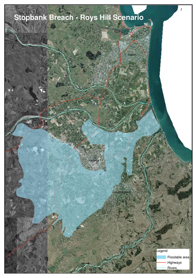
|
Map Taradale Scenario
|
Attachment 3
|
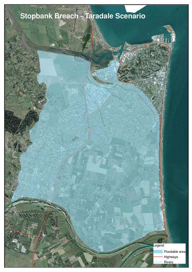
|
Map Moteo Scenario
|
Attachment 4
|
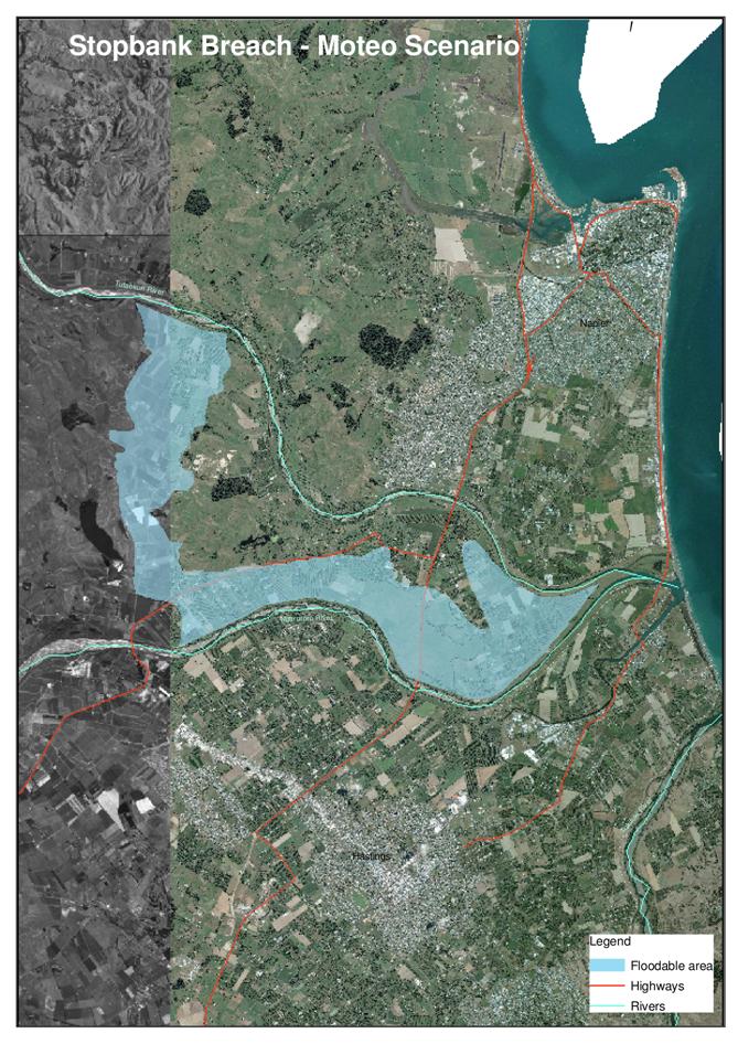
HAWKE’S BAY REGIONAL COUNCIL
Asset
Management and Biosecurity Committee
Wednesday 09 March 2011
SUBJECT: General Business
INTRODUCTION:
This
document has been prepared to assist Councillors note the General Business to
be discussed as determined earlier in Agenda Item 6.
|
Item
|
Topic
|
Councillor
/ Staff
|
|
1.
|
|
|
|
2.
|
|
|
|
3.
|
|
|
|
4.
|
|
|
|
5.
|
|
|
|
6.
|
|
|
|
7.
|
|
|
|
8.
|
|
|
|
9.
|
|
|
|
10.
|
|
|
|
11.
|
|
|
|
12.
|
|
|
|
13.
|
|
|
|
14.
|
|
|
|
15.
|
|
|
|
16.
|
|
|