Meeting of the Hawke's Bay Regional Council Maori Committee


Date:                 Tuesday 22 February 2011

Time:                10.15am

Venue:

Council Chamber

Hawke's Bay Regional Council

159 Dalton Street

NAPIER


Agenda


Item       Subject                                                                                                                  Page


1.         Welcome/Notices/Apologies 

2.         Conflict of Interest Declarations  

3.         Confirmation of Minutes of the  Maori Committee held on 23 November 2010

4.         Matters Arising from Minutes of the  Maori Committee held on 23 November  2010

Decision Items

5.         Short Term Replacements

6.         Consideration of General Business Items

7.         Action Items

Information or Performance Monitoring

8.         Update on Current Issues by CEO - Verbal

9.         Review of Fish Habitat Requirements for the Tukituki and Ngaruroro Rivers

10.       Kahungunu Wai Symposium:  Determining the Kahungunu Flow of a Waterway - Verbal

11.       Regional Stormwater Strategy Update - Verbal

12.       Statutory Advocacy Update

13.       General Business  


HAWKE’S BAY REGIONAL COUNCIL

Maori Committee  

Tuesday 22 February 2011

SUBJECT: Short Term Replacements        


REASON FOR REPORT:

1.      Council has made allowance in the terms of reference of the Committee for short term replacements to be appointed to the Committee where the usual member/s cannot stand.


RECOMMENDATION:

That the Maori Committee :

That ______________  be appointed as member/s of the Maori Committee of the Hawke’s Bay Regional Council for the meeting of Tuesday, 22 February 2011 as short term replacements(s) on the committee for ________________


Viv Moule

Human Resources Manager


Andrew Newman

Chief Executive


Attachment/s

There are no attachments for this report.


HAWKE’S BAY REGIONAL COUNCIL

Maori Committee  

Tuesday 22 February 2011

SUBJECT: Action Items        


REASON FOR REPORT:

1.      There are no action items to be considered at this meeting.


Viv Moule

Human Resources Manager


Attachment/s

There are no attachments for this report.  


HAWKE’S BAY REGIONAL COUNCIL

Maori Committee  

Tuesday 22 February 2011

SUBJECT: Review of Fish Habitat Requirements for the Tukituki and Ngaruroro Rivers        


REASON FOR REPORT

1.      Minimum flows set within the Resource Management Plan are an important component of surface water management.

2.      This report covers the re-assessments of all habitat models in the Tukituki River catchment and a new assessment of the lower Ngaruroro River.  Data and conclusions are provided to support future water management in the Ngaruroro and Tukituki catchments.

3.      The aim of recent habitat modelling work was to provide accurate, robust, and peer reviewed information on the habitat requirements for fish species in the Tukituki and Ngaruroro Rivers.

4.      The flows in this report are based on instream habitat for a range of fish species.  There are many other values within each catchment that need to be considered in addition to fish habitat when setting minimum flows.

Model Reviews:  Tukituki Catchment

5.      A series of instream habitat models were completed for the Waipawa, upper Tukituki, Tukipo, and lower Tukituki Rivers between 1997 and 2007.

6.      Full reports on each model were not completed, rather a summary section was written on habitat modelling data from 1997 as part of the report “Sustainable Low Flow Project: Ruataniwha Rivers” (Wood 1998).  Subsequent models were completed, but full documentation of data collection and modelling methods was not provided in formal reports.

7.      No formal peer reviews were completed for instream habitat models in the Tukituki catchment prior to 2008.

8.      The Cawthron Institute was contracted in September 2008 to review the instream habitat model for the lower Tukituki River (Hay 2008).  The primary purpose of the review was to determine if the model was sufficiently robust to use for successive modelling and would withstand scrutiny in Environment Court and other RMA processes.

9.      The Cawthron review concluded that the model was sufficiently robust if a number of issues were addressed and proper model interpretation methods were employed.

10.    The recommendations in the Cawthron review were used to reconstruct the lower Tukituki model.  Additional reconstructions were completed for the Waipawa, upper Tukituki, and Tukipo models, using the same considerations highlighted in the Cawthron review.

11.    The new versions of models for 2011 in the Tukituki catchment were satisfactorily reviewed by the Cawthron Institute.

Model Reviews: Ngaruroro River

12.    The previous instream habitat model for the lower Ngaruroro River suffered from a number of problems. The decision was made to complete a new river survey to construct a new habitat model for the lower Ngaruroro.

13.    The Ngaruroro model was completed in January 2011 and has been satisfactorily reviewed by the Cawthron Institute.

Model Results

14.    The modelling software RHYHABSIM (River Hydraulics and Habitat Simulation) was used for instream habitat modelling on all five rivers.

15.    RHYHABSIM predicts habitat in the form of weighted usable area (WUA).  WUA is a metric that incorporates habitat quantity and quality.  The data are given per unit of flow and are easily visualised in a graph (Figure 1).

16.    The optimum flow and slope of the WUA curve are the most important features when considering minimum flows as this describes ideal flow for a given fish species and the sensitivity of that species to changes in flow.  The steeper the curve, the more sensitive the species is to flow changes.

17.    Where the optimum flow exceeds the mean annual low flow (MALF), the slope of the curve is used to aid the minimum flow setting process by choosing the flow which provides a particular level of habitat protection.  This is described in further sections.

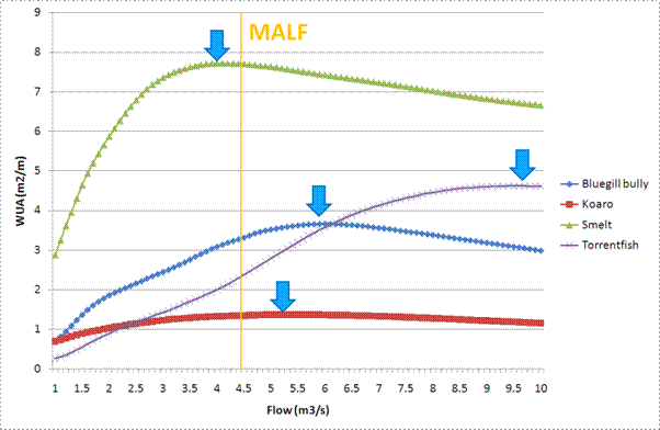
Figure 1: WUA plot for several native species with optimum flows indicated by blue arrows (from Ngaruroro River RHYHABSIM model).

Minimum Flow Considerations

Management Objectives

18.    There are many considerations to be made in the minimum flow setting process, not the least of which is defining the values that the community wishes to maintain or enhance.  It is not the intention of this report to define those values as that process involves all stakeholders in the Tukituki and Ngaruroro catchments as part of a full assessment of RMA Section II (economic, cultural, social, and environmental matters).  However, there are many National and Regional examples to guide minimum flow selection for instream habitat, which have been included in this report.

19.    One of the longstanding management objectives in the major Hawke’s Bay catchments is maintaining high quality rainbow trout fisheries.  Rainbow trout have been a prominent management species for the Tukituki and Ngaruroro Rivers and have been the primary instream management objective for past minimum flow setting processes.

20.    Native fish habitat is becoming an increasingly important topic in minimum flow setting processes.  The latest report on the threat status of New Zealand native fish has assigned a heightened threat status of “At Risk – Declining” to several species that occur in Hawke’s Bay rivers (Allibone 2011).  This indicates a heightened importance of habitat protection for these species.

Habitat Retention Levels

21.    Minimum flow considerations for instream habitat requirements across New Zealand are almost exclusively based on retaining a percentage of the optimum habitat available for the key management species.  Where the optimum habitat of a key species occurs at flows greater than the mean annual low flow (MALF), the habitat retention level is based on a percentage of the habitat level available at the MALF.

22.    This method incorporates two significant concepts; that the instream environment is built around the natural hydrology of the river (where MALF represents a significant control on fish populations), and that reductions in the annual low flow by use of a minimum flow represent an exercise in risk management, whereby increased reductions in the annual low flow (as a result of water abstraction) represent increased risk to fish populations.

23.    The habitat retention levels chosen for the existing lower Tukituki and lower Ngaruroro minimum flows targeted an 80% habitat retention level.  The rationale for this level was that given the natural “variability around the MALF, then a reduction of 20% is seen as reasonable to meet both instream and out of stream requirements” (Wood 2004).

24.    The report for the Waipawa and upper Tukituki recommended minimum flows that provided for a range of species including trout, native fish, and macroinvertebrates (Wood 1998).  A direct comparison cannot be made against new model results as no habitat retention level was specified.

25.    The 2011 Cawthron review highlighted that the final minimum flow recommendation from the lower Tukituki model neither met the objective of providing for 80% habitat retention, nor did it align with habitat retention levels currently used across New Zealand for highly valued rainbow trout fisheries.

26.    National precedent in minimum flow setting is to assign high habitat retention levels for high valued fisheries. Jowett and Hayes (2004) provide suggested habitat retention levels for trout and native fish. For rivers and streams with brown and rainbow trout fisheries, the suggested habitat retention level provides for 90% of habitat available at the MALF, as per Jowett and Hayes (2004). This level has been adopted by several regional councils.

27.    Habitat retention values for native fish have yet to be thoroughly established through precedent as many native fish often have flow requirements less than trout species and native fish do not often comprise significant fisheries (with the exception of eels and whitebait species).

28.    The most up-to-date native fish habitat data indicate that in many Hawke’s Bay rivers, the flow requirements of some native species are equal or greater than rainbow trout.

29.    Also, the recent increase in threat status of a number of native fish species found in Hawke’s Bay indicates that protection of their habitat would be of regional and national importance.

Summary of Results

30.    Data for all the included catchments have been compiled to show the previous minimum flows, the flows required to retain 80% of habitat available at the MALF, and the % of MALF that each minimum flow represents (Table 1).  This table has been compiled to present a direct comparison of the current minimum flows and the minimum flows required to meet the original management objective of 80% habitat retention for rainbow trout, based on the updated model results.  Please note the minimum flows for the Waipawa and upper Tukituki incorporated a number of species’ habitat requirements, so a direct comparison cannot be made.  See Wood (1998) for a full description of the minimum flow recommendations.

Table 1: Compiled minimum flow data for all modelled rivers with comparisons to the mean annual low flow (MALF).

River

Current Minimum Flow

Current Minimum Flow as %MALF

Flow Demanding Species

Flow necessary for 80% habitat retention level*

Flow necessary for 80% habitat retention level as %MALF

Lower Tukituki


3500 l/s

57%

Rainbow trout

Torrentfish

4300 l/s

5100 l/s

67%

80%

Waipawa

2300 l/s

77%

Rainbow trout and longfin eel

2000 l/s

67%

Upper Tukituki

1900 l/s

68%

Rainbow trout and longfin eel

1800 l/s

64%

Tukipo

150 l/s

81%

Rainbow trout and bluegill bully

150 l/s

81%

Ngaruroro

2400 l/s

53%

Rainbow trout

torrentfish

3400 l/s

3900 l/s

76%

87%

*all habitat retention levels refer to the % of habitat available at MALF

31.    Flow requirements for key management species (defined here as the most flow demanding or having high fishery value) have been compiled (Table 2). This table shows the flows necessary to align with current precedent from other New Zealand river systems regarding habitat retention levels.

Table 2: Flows required to maintain 90% of habitat available at the MALF for key management species and the %MALF each flow represents.

River

Key Management Species

Flow necessary for 90% habitat retention level

Flow necessary for 90% habitat retention level as %MALF

Lower Tukituki


Rainbow trout

Torrentfish

5300 l/s

5800 l/s

87%

95%

Waipawa

Rainbow trout

Longfin eel

2400 l/s

2500 l/s

80%

83%

Upper Tukituki

Rainbow trout and longfin eel

2200 l/s

79%

Tukipo

Rainbow trout

Bluegill bully

175 l/s

163 l/s

94%

88%

Ngaruroro

Rainbow trout

torrentfish

3900 l/s

4200 l/s

87%

93%

*all habitat retention levels refer to the % of habitat available at MALF


References

Allibone, R., David, B., Hitchmough, R., Jellyman, D., Ling, N., Ravenscroft, P., Waters, J. 2010. Conservation status of New Zealand freshwater fish, 2009. New Zealand Journal of Marine and Freshwater Research. v44:3, 129-148.

Hay, J. 2008. Review of Hawke’s Bay Regional Council’s Instream Habitat Modelling on the Lower Tukituki River. Prepared for Hawke’s Bay Regional Council. Cawthron Report No. 1542.

Jowett I.G., Hayes, J.W. 2004. Review of methods for setting water quantity conditions in the Environment Southland draft Regional Water Plan. Prepared for Southland Regional Council. NIWA Client Report HAM2004-018.

Wood, G. 1998. Sustainable Low Flow Project: Ruataniwha Rivers Waipawa – Tukipo – Tukituki. Hawke’s Bay Regional Council Environmental Management Group Technical Report EMT 98/2. ISSN 1174-3077.

Wood, G. 2004. Lower Tukituki IFIM. Hawke’s Bay Regional Council Environmental Management Group Technical Report, Unpublished.

DECISION MAKING PROCESS

32.    Council is required to make a decision in accordance with Part 6 Sub-Part 1, of the Local Government Act 2002 (the Act).  Staff have assessed the requirements contained within this section of the Act in relation to this item and have concluded that, as this report is for information only and no decision is to be made, the decision making provisions of the Local Government Act 2002 do not apply.


RECOMMENDATION

1.    That the Maori Committee receives the report.


Kolt Johnson

Scientist


Rob Christie

Team Leader - Hydrology


Graham Sevicke-Jones

Manager Enviromental Science


Darryl Lew

Group Manager

Resource Management


Attachment/s

There are no attachments for this report.  


HAWKE’S BAY REGIONAL COUNCIL

Maori Committee  

Tuesday 22 February 2011

SUBJECT: Statutory Advocacy Update        


REASON FOR REPORT

1.      This paper reports on proposals considered under Council’s statutory advocacy project and the Resource Management Act 1991.

Background

2.      The proposals on which Council has an opportunity to make comments or lodge a submission include, but are not limited to:

2.1  Notified Resource Consent Applications

2.2  Plan Changes

2.3  Private Plan Change Requests

2.4  Notices of Requirement

2.5  Non-statutory Strategies and Structure Plans.

3.      The summary attached includes an actual list and description of the proposals, whether submissions were lodged in support or opposition, and the reasons for lodging a submission. A location map is also attached.

DECISION MAKING PROCESS

4.      Council is required to make a decision in accordance with Part 6 Sub-Part 1, of the Local Government Act 2002 (the Act).  Staff have assessed the requirements contained within this section of the Act in relation to this item and have concluded that, as this report is for information only and no decision is to be made, the decision making provisions of the Local Government Act 2002 do not apply.

RECOMMENDATION

That the Maori Committee receives the Statutory Advocacy Update Report.


Esther-Amy Bate

Planner


Gavin Ide

Team Leader Policy


Attachment/s

1View

Stat Ad Map


2View

Stat Ad Update


Stat Ad Map

Attachment 1


Stat Ad Update

Attachment 2


Statutory Advocacy Update

Received

TLA

Map Ref

Activity

Applicant/ Agency

Status

Current Situation

16 November 2010

RDC

1

Proposed District Plan

The Proposed Rangitikei District Council Plan October 2010.

RDC

Proposed

6 December 2010

·  Proposed District Plan received for Councils review.  Plan reviewed no further action required.

5 November 2010

NCC

2

Notice of Requirement – Te Awa Structure Plan

Notice of requirement for designation to allow for the construction of public works in the Te Awa Structure Plan area by Napier City Council.

NCC

Notified by NCC

6 December 2010

·  The Council’s Engineering Team has provided comment.  The Engineering Team believes that the proposed second pump station is unnecessary due to sufficient infrastructure already available in that there is scope to utilise infrastructure previously built for the Cross Country drain.

·  Council will submit in support but provide further comments on the above.

5 November 2010

NCC

2

Plan Change 6 – Te Awa Structure Plan

The purpose of the plan change is to rezone the area from Main Rural to Main Residential and incorporate the outcomes sought in the Te Awa Structure Plan into the District Plan.

NCC

Notified by NCC

6 December 2010

·  Engineering Team has provided comments.  The proposed stormwater solution does not consider Low Impact Urban Design principles.  It also appears that the four Wellbeings of Economic, Social. Cultural and Environment have not adequately been considered in the Structure Plan.

·  Council will submit in support of the application but provide comment on the above.

7 October 2010

HDC

3

Notice of Requirement – Arataki School

The applicant seeks to designate land at 139 Arataki Road for Education purposes.  The designation will provide land to construct a Primary School and early childcare facility.  The site is currently owned by the Arataki Campground.

Ministry of Education


Consultant –

OPUS International Consultants

Notified by HDC

15 October 2010

·  Proposal has been assessed. No issues warrant lodging a submission.

·  Detailed site development plans for site layout and configuration yet to be prepared by MOE.  Detailed plans to follow if designation approved.

20 September 2010

NCC

4

Resource Consent – Subdivision

The applicant proposes to subdivide an area of land currently part of the Snapper Holiday Park for a 2 lot residential subdivision.  The address of the property is 10 Gill Road and the legal description is Lot 2 DP 28507.

J.A. & J.S. Coyle


Consultant – Wallis Consultants

Notified Restricted Discretionary

15 October 2010

·  Proposal has been assessed.  No issues warrant lodging a submission.

·  Resource consent for the discharge of wastewater from proposed lots previously granted.

17 September 2010

NZTA

5

State Highway 2 & State Highway 5 Intersection

The purpose of the project is to improve the safety and efficiency of this section of State Highway network.

NZTA


Consultant - MWH

Pre-application

15 October 2010

·  Comments received from Operations Group.  No preliminary issues of concern from Engineering and Operations sections.

·  Council has no land within the proposed area.  Access for maintenance is through Wairoa Road (SH2).

17 September 2010

NCC

6

Resource Consent – Land Use

The applicant proposes to establish a Napier Plunket Centre to be located within Lot 6 DP 10462 Recreation Reserve (1983/4071) which forms Onekawa Park in Napier.

Royal NZ Plunket Society


Consultant – Eos Design

Notified Discretionary

15 October 2010

·  Proposal has been assessed.  No issues warrant lodging a submission.

·  HAIL database records site as location of a historical landfill and that there maybe contamination issues.

·  In lieu of submission, letter sent to Napier CC and applicant advising HAIL classification.  Napier CC already has this information.  Letter suggested further investigation be undertaken to confirm landfill situation.

17 September 2010

CHBDC

7

Resource Consent – Subdivision

The applicant’s agent sought information relating to the wastewater requirements for Lot 2 DP 430476 Pt Lot A DEEDS 16 DCDB Document ID: CT M2/629 or 793 SH2 Otane should an application for subdivision be sought.

Consultant -

Dagg & Thorn Surveyors

Pre-Application

20 September 2010

·  Land elevation contour information was provided to the consultant by the Engineering section.  Policy provided regulatory advice on the RRMP.

·  Applicant yet to lodge formal application.

9 September 2010

NCC

8

Resource Consent - Subdivision

The applicant seeks to undertake a 2 Lot subdivision to create one (1) 0.178 hectare residential Lot (being proposed Lot 1) and a balance Lot which will be 3.31 hectares (being proposed Lot 2).  The address for the subdivision is 45 Rogers Road, Bay View, legal description Lot 4 DP 7344.

Cindy McKinnie


Consultant –

Consult Plus

Notified Restricted Discretionary


7 December 2010

·  Application Hearing held on 24th November, Application declined by NCC.


8 October 2010

·  HBRC lodged submission opposing application.  Consent should be declined unless the proposed 2 residential lots are fully serviced or sufficient information is provided to show that adverse effects of on-site wastewater discharges (particularly in combination with the proposed soak-pit means of stormwater disposal), will be adequately avoided, remedied or mitigated. 

·  Submission stated installation of a reticulated sewage system for the Bay View community to be a sustainable long-term solution for the treatment and disposal of wastewater.

·  Submission also seeks clarification of floor level for flooding risk also requested.

23 August 2010

NCC

9

Resource Consent – Subdivision

The application seeks to subdivide 58 McElwee Street, Jervoistown Certificate of Tile HBM2/1351 into two separate lots.

Mr B. Joseph


Consultant –

Consult Plus

Notified Restricted Discretionary

27 January 2011

·  Council has become a party to the appeal lodged by the applicant under Section 274 of the Resource Management Act 1991.  The Council is interested in all of the proceedings but in particular is interested in issues relating to the effects of increased site coverage and stormwater collection, treatment and disposal.


16 December 2010

·  Council has received a Notice of Appeal from the applicant on the NCC decision.   


17 November 2010

·  Application was declined at Hearing held 17 November 2010 as it was decided that the creation of two 2000m2 lots was contrary to the intent of the Napier District Plan.


20 September 2010

·  HBRC lodged submission opposing application.

·  Reasons include:

No provision for stormwater disposal and will likely result in adverse conditions in terms of flood levels and duration of flooding at a local level and the wider Jervoistown community. 

Proposal to increase maximum site coverage from 10% to 25%.  Concern that this will also increase adverse conditions in terms of flood levels and duration of flooding.

·  A 2009 report prepared by this Council (Jervoistown Drainage Analysis, Hawke’s Bay Regional Council, April 2009) outlines the drainage issues and provides the conclusion that incremental development at Jervoistown will continue to result in reduced drainage standard for the existing houses.  A copy of this report was provided to Napier CC shortly after its publication.

12 July 2010

NCC

10

Resource Consent – Land use

The application seeks to locate two existing facilities to one building located at 82 Taradale Road, Napier, where an extensive refurbishment and revitalisation project is proposed.

Department of Corrections


Consultants –

MWH

Limited Notification Discretionary

15 October 2010

·  Applicant further reviewing options prior to hearing.


13 July 2010

·  HBRC lodged submission in opposing application.  Decision requested that application be declined unless the bus stop which the applicant proposes to remove is replaced with a new in-set bus stop on Taradale Road, midway between Carnegie Road and Austin Street.

24 May 2010

NCC

11

Resource Consent - Subdivision

The application seeks to subdivide an area of land currently zoned as main rural on Franklin Road, Bay View into 6 lots and undertake earthworks.

Gerald Howe


Consultant – Alan Petersen

Notified Restricted Discretionary

15 October 2010

·  No recent activity.


2 August 2010

·  Policy staff have met with the applicant’s consultant.  Options and scenarios for wastewater consenting and servicing are under consideration.


14 July 2010

·  Council submitted in opposition to the application seeking that the application be declined unless all of the 6 Lots were fully serviced.


12 June 2010

·  Comment has been sought from the Regulation and Engineering teams.  The stormwater solutions for the site are acceptable due to the free draining nature of the soils.  The same soil types present an issue with on-site wastewater disposal and insufficient treatment.  Coupled with the proximity of the subdivision to the coastal marine environmental it is likely that the Council will submit against the application.  Submissions closed 24 June 2010.

18 January 2010

CHBDC

12

Plan Change 1 – Fault lines

This change identifies more accurately the fault lines that Waipukurau, Waipawa and Otane and introduces new rules which reflect the expected level of risk associated with earthquakes.

CHBDC

Notified by CHBDC

14 December 2010

·  CHBDC has placed the application on hold while further feasibility investigations are carried out.


15 October 2010

·  Awaiting CHBDC to confirm hearing arrangements.


15 March 2010

·  Further submissions invited. HBRC further submission unnecessary.


16 February 2010

·  Submission lodged in support of the Plan Change.


4 February 2010

·  This Plan Change is a result of work undertaken by Geological Nuclear Science (GNS) to locate and define fault lines in Central Hawke’s Bay at the instigation of HBRC and CHBDC.

·  The Study “Earthquake Fault Trace Survey: Central Hawke’s Bay District” (GNS Science Consultancy Report 2006/98) has been received and accepted buy Council Staff.

·  As HBRC instigated the work it is likely that a submission will be lodged in favour of the Plan Change.


26 June 09

HDC

n/a

Plan Change 49 – Rural Zone Subdivision

The plan change seeks to amend the rules regarding the creation of lifestyle sites to ensure that the issues associated with applications for multiple lifestyle sites being created at once can be managed more effectively.

HDC

Notified by HDC

27 August 2010

·  Hastings DC issued decisions on submissions.  No decisions warrant appeal by HBRC.


3 February 2010

·  Further submissions closed 29/010/10.

·  Council spoke with HDC staff no need for further submission as original submission supports PC in its entirety.


7 August 2009

·  Council has submitted in support of PC49 as it considers that the PC will contribute to the sustainable management of the rural zone by restricting the current rate of rural subdivision for residential purposes.


17 July 2009

·  PC 49 under evaluation.

20 January 2009

HDC

13

Proposed Private Plan Change

The plan change will seek to rezone land at Elwood Road, Tomoana from Plains to Industrial.  The subject land comprises 16.4286 hectares and is legally described as Lot 3 DP 27427 and Lot 1 DP 27890.  The site directly adjoins land zoned Industrial 2 known as the Tomoana Industrial Area.

Elwood Road Holdings


Consultant - MWH

Pre-Application

3 June 2010

·  Council receives the applicant’s stormwater and water proposal for its comments.  A meeting between Council and the applicant is scheduled for in late June.

23 March 2009

·  Council provided comments to MWH on stormwater and the historical Tomoana Freezing Works offal disposal sites (pye holes).

20 January 2009

·  MWH request Councils comments on the proposed Plan Change

14 March 2008

NCC

14

Plan Change 2 – Business Park Zone

The plan change proposes to rezone 30 hectares located immediately north of Prebensen Drive and west of the Hawke’s Bay Expressway Legal Description (Lot 114 DP 377350) and backing onto the Southern Marsh, part of the Ahuriri Estuary.

NCC

Notified by NCC

31 May 2010

·  Council’s Engineering Team assessed stormwater management plan and found contaminant solution acceptable.  Council’s concerns would be satisfied by management plan’s proposals.

·  Napier CC to confirm hearing arrangements.

30 April 2010

·  Council received stormwater management plan for the business park.

23 April 2010

·  Letter received confirming Council’s submission and inviting further submissions.  No further submission is lodged.

14 March 2008

·  The Council opposes the Plan Change due to concerns related to the discharge of contaminants from stormwater into the Ahuriri Estuary.


HAWKE’S BAY REGIONAL COUNCIL

Maori Committee

Tuesday 22 February 2011

SUBJECT: General Business        


INTRODUCTION:

This document has been prepared to assist Councillors note the General Business to be discussed as determined earlier in Agenda Item 6.

Item

Topic

Councillor / Staff

1.   


2.   


3.   


4.   


5.   


6.   


7.   


8.   


9.   


10. 


11. 


12. 


13. 


14. 


15. 


16.