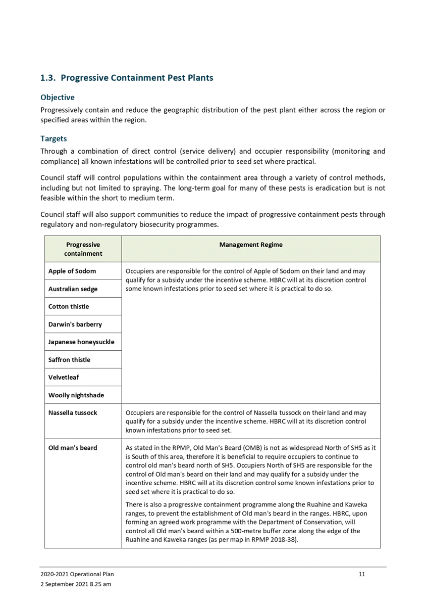
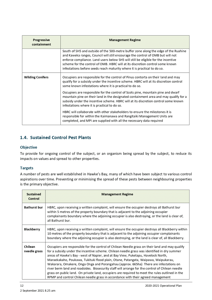
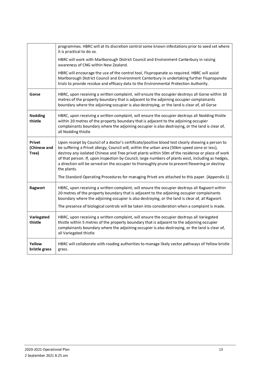
Meeting of the Environment and Integrated Catchments
Committee
Date: Wednesday 8 September 2021
Time: 9.00am
|
Venue:
|
Council Chamber
Hawke's Bay Regional Council
159 Dalton Street
NAPIER
|
Agenda
Item Title Page
1. Welcome/Karakia/Notices/Apologies
2. Conflict
of Interest Declarations
3. Confirmation of Minutes of the Environment and Integrated Catchments
Committee held on 23 June 2021
4. Follow-ups from
Previous Environment and Integrated Catchments Committee Meetings 3
5. Call for Minor
Items Not on the Agenda 7
Decision Items
6. Biosecurity
2020-21 Annual Report and 2021-22 Operational Plan 9
7. Right Tree Right
Place Project Acceleration 59
Information or Performance Monitoring
8. Enviroschools
2020-21 Update 65
9. Possum Control
Area Partial Plan Review Update 69
10. An Introduction to the
Catchments Policy Implementation Work Programme 77
11. Tukipo Wetland 87
12. Update on the 3D Aquifer
Mapping Project (SKYTEM) 91
13. Update on the Whakaheke o Te
Wai (TWOTW): MBIE Funded Endeavour Programme and Heretaunga Plains Groundwater
Case Studies 97
14. Update on IRG Flood Control
Resilience Funded Projects 101
15. Public Use of Rivers 107
16. Call for Certificate of
Appreciation Nominations 125
17. Discussion of Minor Items not
on the Agenda 127
HAWKE’S
BAY REGIONAL COUNCIL
Environment and
Integrated Catchments Committee
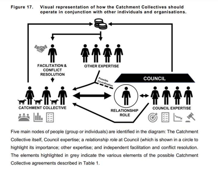
Wednesday 08 September 2021
Subject: Follow-ups from
Previous Environment and Integrated Catchments Committee Meetings
Reason
for Report
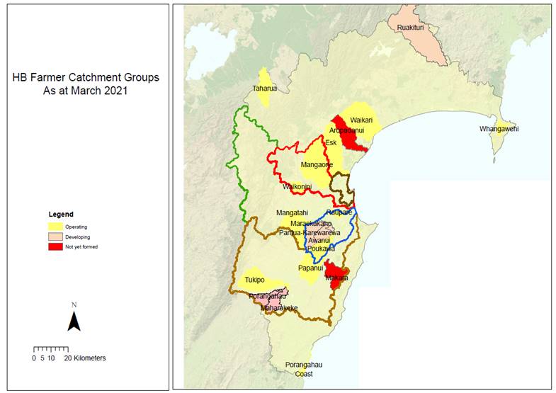
1. On the list attached are items raised at previous Environment and
Integrated Catchments Committee meetings that staff have followed up on. All
items indicate who is responsible for follow up, and a brief status comment.
Once the items have been reported to the Committee they will be removed from
the list.
Decision
Making Process
2. Staff have assessed the requirements of the Local Government Act
2002 in relation to this item and have concluded that, as this report is for
information only, the decision-making provisions do not apply.
Recommendation
That the Environment and Integrated Catchments Committee
receives and notes the “Follow-ups from Previous Meetings”.
Authored by:
|
Annelie Roets
Governance ADVISOR
|
|
Approved by:
|
Chris Dolley
Group Manager Asset Management
|
Iain Maxwell
Group Manager Integrated Catchment
Management
|
Attachment/s
|
1⇩
|
Followups for
September 2021 EICC meeting
|
|
|
|
Followups
for September 2021 EICC meeting
|
Attachment 1
|
HAWKE’S BAY REGIONAL COUNCIL
Environment
and Integrated Catchments Committee
Wednesday 08 September 2021
Subject: Call for Minor Items
Not on the Agenda
Reason
for Report
1. This item provides the means for committee members to raise minor
matters relating to the general business of the meeting they wish to bring to the attention of the meeting.
2. Hawke’s Bay Regional Council standing order 9.13
states:
2.1. “A
meeting may discuss an item that is not on the agenda only if it is a minor
matter relating to the general business of the meeting and the Chairperson
explains at the beginning of the public part of the meeting that the item will
be discussed. However, the meeting may not make a resolution, decision or
recommendation about the item, except to refer it to a subsequent meeting for
further discussion.”
Recommendations
That the Environment and Integrated Catchments Committee accepts the
following “Minor Items
Not on the Agenda” for discussion as Item 17:
|
Annelie Roets
GOVERNANCE ADVISOR
|
James Palmer
CHIEF EXECUTIVE
|
HAWKE’S BAY REGIONAL COUNCIL
Environment
and Integrated Catchments Committee
Wednesday 08 September 2021
Subject: Biosecurity 2020-21
Annual Report and 2021-22 Operational Plan
Reason for Report
1. This item presents the Hawke’s Bay Regional Council’s
Biosecurity Annual Report for the 2020-21 year and Operational Plan for the
2021-2022 year.
Executive Summary
2. Pest management is an important part of the sustainable management
of natural resources in Hawke’s Bay. The Hawke’s Bay Regional
Council (Council) manages risks posed by pests and other organisms through its
Biosecurity programme. The Hawke’s Bay Regional Pest Management Plan
(RPMP) 2018-2038 is the core document behind this and establishes the
regulatory basis for pest management in Hawke’s Bay. The RPMP was
made operative in February 2019.
3. As the management agency, Council is directed by the Biosecurity Act
1993 (the Act) to prepare an Annual Operational Plan (AOP) that sets out how
the RPMP is to be implemented. Following the end of each financial year,
Council is required to produce an Annual Report (AR), recording progress in
implementation of the RPMP via the Operational Plan.
Background
4. Regional councils have a mandate under Part 2 of the Act to provide
regional leadership in activities that prevent, reduce, or eliminate adverse
effects from harmful organisms that are present in their region. HBRC therefore
has this leadership role in the Hawke’s Bay region.
5. The purpose of the RPMP is to provide for the efficient and
effective management or eradication of specified harmful organisms in the
Hawke’s Bay region. It builds on the 2013 Strategy and previous pest
management programmes. The purpose of the Plan is to:
6.1 minimise the actual or potential adverse or unintended effects
associated with those organisms; and
6.2 maximise the effectiveness of individual actions in managing pests
through a regionally coordinated approach.
6. Many organisms in the Hawke’s Bay region are considered
undesirable or a nuisance. The RPMP only addresses pests where voluntary action
is insufficient due to the nature of the pest or the related costs and benefits
of individual action or inaction. The Act specifies criteria that must be met
to justify such intervention.
7. The RPMP empowers Council to exercise the relevant advisory, service
delivery, regulatory and funding provisions available under the Act to deliver
the specific objectives identified within the Plan.
Discussion
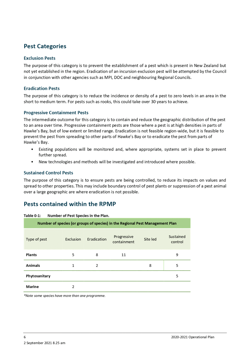
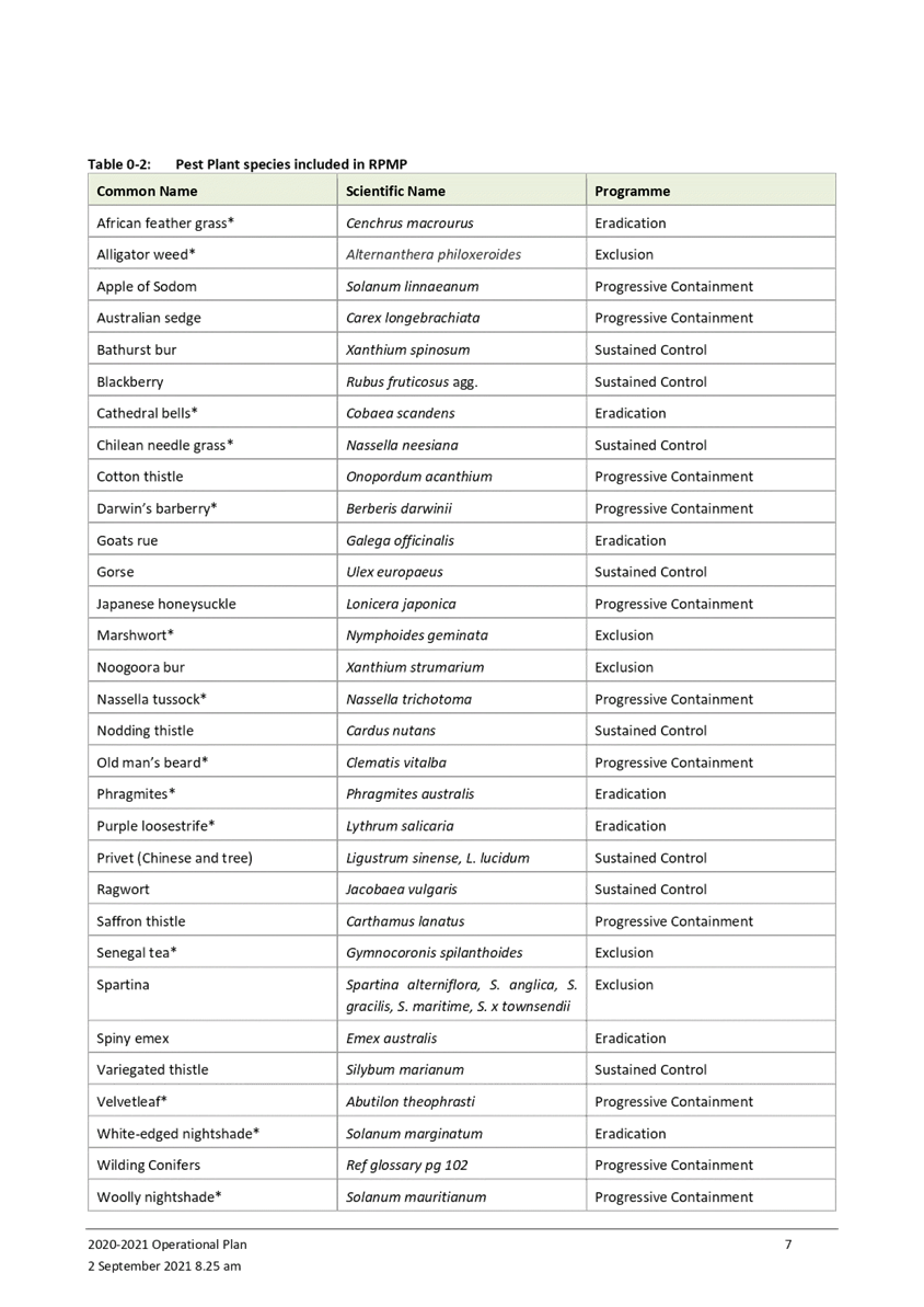
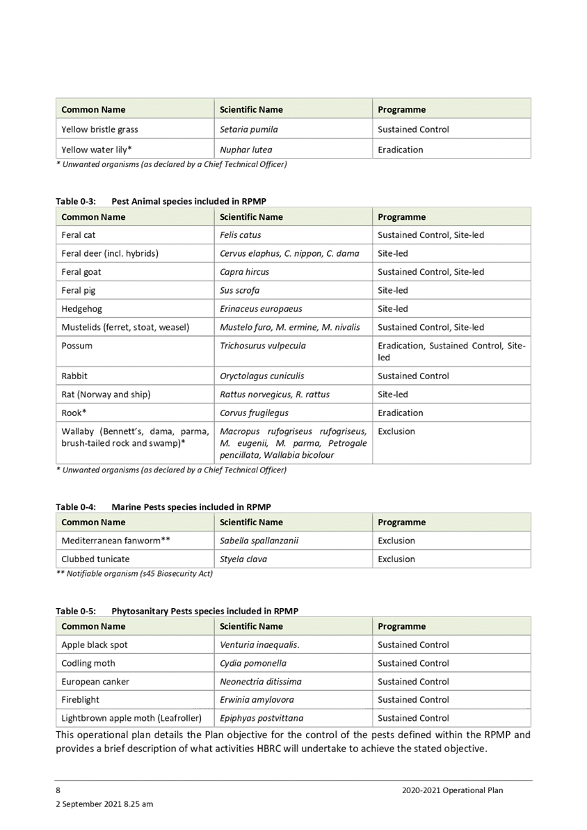
8. The RPMP contains 63 pests, comprising of 33 pest plants, 23 pest
animals, two marine pests and five horticultural pests.
9. Some of the key outputs during the 2020-2021 financial year were:
9.1. The Pest Plant team visited 2,100 properties undertaking weed
control or auditing
9.2. Staff undertook 5 biocontrol releases (Californian green thistle
beetle)
9.3. No exclusion pest plants were detected in the Hawke’s Bay
region
9.4. Eight Notices of Direction were issued
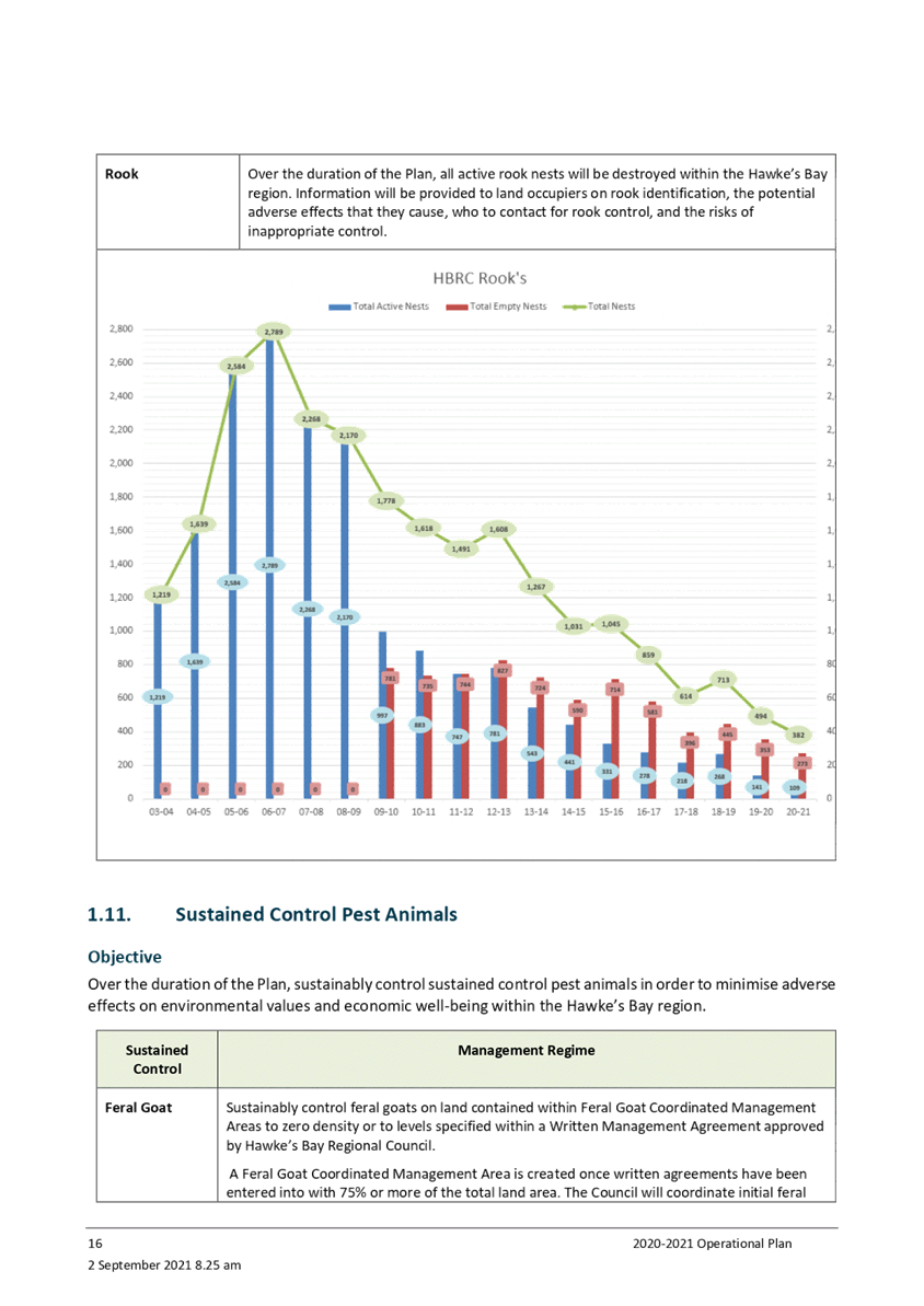
9.5. A total of 109 active rook nests were treated
9.6. A total of 755 feral goats were controlled within the Mahia and
Maungaharuru feral goat coordinated management areas (CMA)
9.7. A total of 70 rabbit enquiries were responded to
9.8. Staff worked with 39 land occupier/community groups in managing site
specific pests, primarily predators
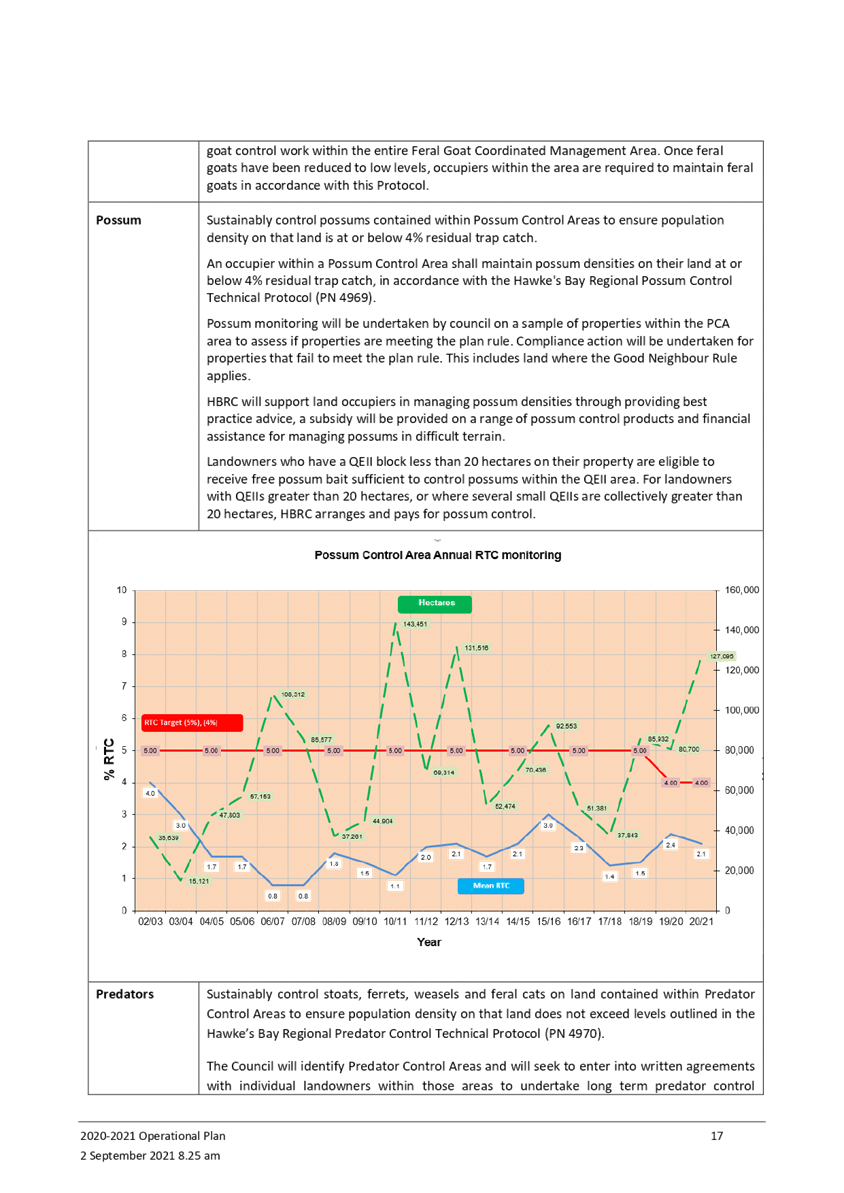
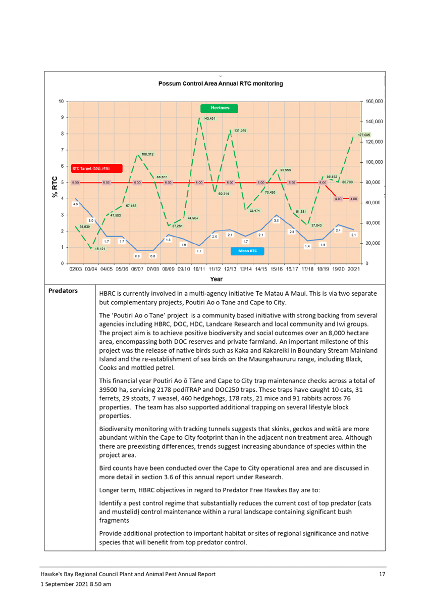
9.9. Possum monitoring was undertaken across 127,000 ha (approximately
18% of the PCA area) with the overall trap catch across the area being 2.1%
9.10. Predators
were controlled over 54,000 ha, removing 10 feral cats, 31 ferrets, 29 stoats,
460 hedgehogs and 178 rats
9.11. Outcome
monitoring showed increases in native bird abundance within the predator
control areas.
10. Although
almost all programme objectives were achieved, the following areas of concern
were identified:
10.1. 226
possum monitoring lines were above a 4% RTC, resulting in 18 properties failing
their monitor (19.9% of properties monitored). These properties were followed
to ensure additional possum control occurred to reduce numbers.
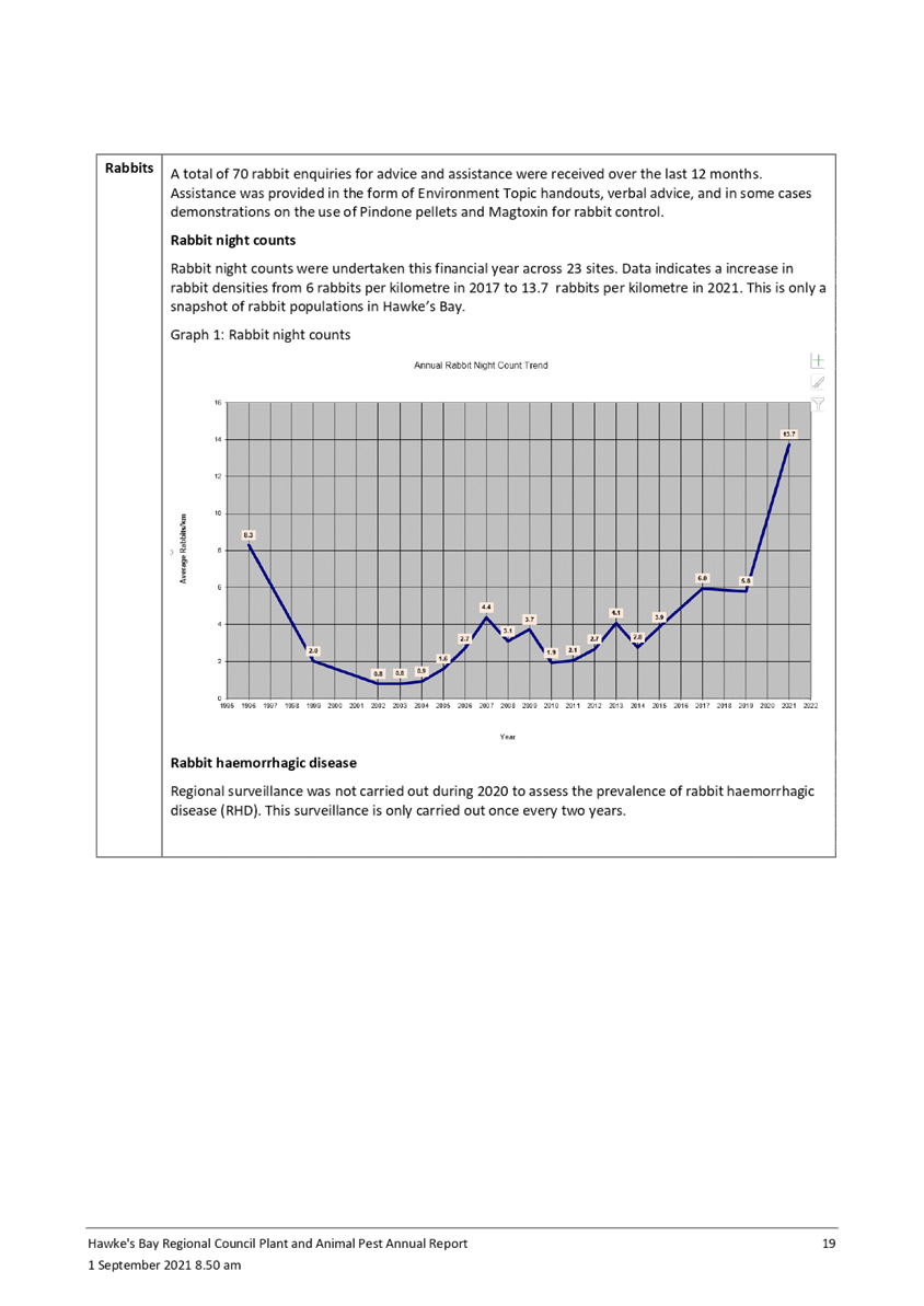
10.2. Rabbit
enquiries continue to increase, particularly in urban areas. Rabbits are a
difficult pest to control, requiring expensive ongoing management. Regional
night count lines indicate an increase from 5.8 to 13.7 rabbits per spotlight
kilometer. The management of rabbits continues to be a discussion across
the sectors biosecurity experts as it is recognized to be a national not
regional problem.
10.3. The
number of properties with pest plants (primarily Chilean Needle Grass)
continues to grow, resulting in increased pressure on Pest Plant budgets and
staff.
Strategic Fit
11. Regional
pest management sits within a biosecurity framework for the Hawke’s Bay
region, which includes the RPMP, the Hawke’s Bay Biodiversity Strategy
and the HBRC Strategic Plan. Neighbouring Regional Pest Management Plans and
national legislation, policy and initiatives have also influenced Hawke’s
Bays RPMP.
12. The
activity that is reported in the AOR and AP support Council’s healthy
functioning biodiversity priority area in it Strategic Plan and the strategic
outcome that Agricultural and environmental pests are managed and eradicated
through the Regional Pest Management Plan.
Next steps
13. A
proposal to undertake a partial plan review of the PCA programme was agreed by
the EICC in May this year. This partial plan review process is underway and is
reported separately to the EICC on this committee agenda.
14. A review
of the Chilean Needlegrass programme is underway and will be reported to the
November EICC.
15. Staff
have continued having a significant level of communication with OSPRI, who have
moved to a new geographically based operating model, with staff now based in
the region. There are currently 17 herds infected. OSPRI believe they are
managing the outbreak and expect the number of infected herds to drop
substantially over the next 6 months.
Decision Making
Process
16. Council
and its committees are required to make every decision in accordance with the
requirements of the Local Government Act 2002 (the Act). Staff have assessed
the requirements in relation to this item and have concluded:
16.1. The
decision does not significantly alter the service provision or affect a
strategic asset, nor is it inconsistent with an existing policy or plan.
16.2. The use
of the special consultative procedure is not prescribed by legislation.
16.3. The
decision is not significant under the criteria contained in Council’s
adopted Significance and Engagement Policy.
16.4. The persons affected by
this decision are all persons in the region with an interest in the
region’s biosecurity activities and biodiversity outcomes.
16.5. Given
the nature and significance of the issue to be considered and decided, and also
the persons likely to be affected by, or have an interest in the decisions
made, Council can exercise its discretion and make a decision without
consulting directly with the community or others having an interest in
the decision.
|
Recommendation
1. That
the Environment and Integrated Catchments Committee
receives and notes the “Biosecurity 2020-21 Annual Report and
2021-22 Operational Plan” staff report.
2. The Environment and Integrated Catchments Committee recommends that
Hawke’s Bay Regional Council:
2.1. Agrees that
the decisions to be made are not significant under the criteria contained in
Council’s adopted Significance and Engagement Policy, and that Council
can exercise its discretion and make decisions on this issue without
conferring directly with the community or persons likely to have an interest
in the decision.
2.2. Adopts the Biosecurity
Operational Plan for 2021-22.
|
Authored by:
|
Campbell
Leckie
Manager Catchment Services
|
Mark Mitchell
Team Leader Principal Advisor Biosecurity
Biodiversity
|
Approved by:
|
Iain Maxwell
Group Manager Integrated Catchment
Management
|
|
Attachment/s
|
1⇩
|
2021-22
Combined Pest Plant and Pest Animal Operational Plan
|
|
|
|
2⇩
|
HBRC
Biosecurity Annual Report July 2020 - June 2021
|
|
|
|
2021-22
Combined Pest Plant and Pest Animal Operational Plan
|
Attachment 1
|

|
HBRC Biosecurity Annual
Report July 2020 - June 2021
|
Attachment 2
|

HAWKE’S
BAY REGIONAL COUNCIL
Environment and
Integrated Catchments Committee
Wednesday 08 September 2021
Subject: Right Tree Right Place
Project Acceleration
Reason for Report
1. This item requests approval from the Council to bring
forward up to $500,000 in operating expenditure out of the total committed Long
Term Funding for the for the Right Tree Right Place (RTRP) project. The funds
are to be moved from year-3 (2023-24) to year-1 (2021 22) and the expenditure
is funded from reserves (Sale of Land Reserve).
Officers’ Recommendation(s)
2. That
the committee receives the update on initial progress with RTRP Pilot project
and initial project timing; and
3. That the
committee recommends that Council approves the request for a change of timing,
with up to $500,000 of expenditure brought forward from year-3 to year-1 of the
approved 2021-31 LTP budget.
Executive Summary
4. This matter was
workshopped with Council on 4 August 2021.
5. From a project
planning perspective, the RTRP project is being viewed as two parallel, but
aligned streams of work: The RTRP Pilot aimed to plant up to five farms and due
diligence on a scale-up to move it to a market driven approach.
6. Aligning the
RTRP Pilot with the scale-up assessment requires up to $500,000 Opex funding to
be brought forward in the approved 3-year LTP funding in order to accelerate
aspects of planned work.
7. If the due
diligence on the scale-up opportunity is successful, it may result in earlier
than anticipated funding from external impact related funders.
8. Investment
advice and investigation will be required during the due diligence process on
commercial aspects of a scaled-up impact investment proposition, including
investment vehicle and governance arrangements proposed during the due
diligence process.
9. Since approval
of LTP funding, the RTRP project is gathering momentum with the current focus
on developing the project/procurement plan and budget.
Background /Discussion
10. The significant challenges
facing the region about the adverse impacts of erosive processes and
corresponding sedimentation alongside its response to climate change have been
well traversed with Council. Targeted afforestation is a critical tool to
achieve a range of outcomes that this Council is seeking.
11. Council
has identified approximately 250,000ha of the region that has land
eroding at more than 1000 tonnes/km2/yr.
There is expected to be around 10,000ha of the highest risk land planted over
the next ten years by grant funding initiatives directly supported by Council
such as through Council’s investment of $30M in the Erosion Control
Scheme. However, the scale of the regional context still represents significant
challenges, risks and opportunities.
12. During the 2021-31 LTP
process, Council was presented how the RTRP project can
address the significant erosion problem through demonstrating a successful RTRP
model by refining a planting model with several objectives:
12.1. To recover its own costs
12.2. Encourage planting of
trees on erodible land
12.3. Stimulate the market to
invest in trees on farms that strengthens financial and environmental outcomes
12.4. Reducing the need for
whole farm afforestation
12.5. Plant enough trees to
prepare for climate change; and
12.6. Significant
environmental benefits.
13. Council committed to fund
the RTRP project ~$4.8M through the 2021-31 LTP process apportioned as follows:
13.1. $2.6M in Capex for
planting trees by providing debt funding to farmers to be repaid with interest
over 10 years; and
13.2. $2.2M in Opex from reserves
to fund operational aspects of the project over 3-years with the goal of
recovering this cost if the pilot trial is scaled up.
RTRP Project Update
14. Council are reminded that
staff workshopped this paper with them and its content on 4 August.
15. This section provides a
brief update on the RTRP Pilot project following Council’s approval of
$4.8M in funding in late June 2021. A project lead has been appointed –
Michael Bassett-Foss has transitioned into the role and completed a hand-over
process from Campbell Leckie. Campbell will continue to offer guidance as
required.
16. A discussion is underway
with the Catchment Delivery team (CDT) to integrate RTRP into their service
offering with farmers. In time, they will be able to assist the filtering of suitable
farms and updating a database with potential RTRP farm information.
17. CDT is assisting to
collate a shortlist of potential farms suitable as RTRP pilot farms. Farm
selection criteria have been developed and discussions are underway with
several potential pilot farm landowners.
18. Procurement and project
plans are being developed with associated project budgets being compiled.
19. Progress has started on
assessing the potential to scale-up the RTRP concept with the use of an
external impact funding model alongside partners.
RTRP Comms and Engagement
20. Fundamental to this
project is engagement, education and attitude change with the farming sector
toward afforestation. Comms and engagement are a critical component to the
project. Communications with farmers and wider industry has ramped up.
20.1. Our communication team
is developing five short videos of farmer leaders telling their stories about
planting trees. Three videos have been released already across the
Council’s and other key stakeholder social media platforms. The videos
have been very successful, with high engagement. Wairoa farmer Dave
Read’s video reached over 10,000 people and the video was viewed over
7,000 times. To see the videos, go to hbrc.govt.nz and search #RTRP. The videos
are being developed into case study briefs and will be published in local media
publications
20.2. High level information
has been included in various farmer communication channels including
HBRC’s Our Environment section of Hawke’s Bay Today, CHB Mail and
Wairoa Star
20.3. Communications
and Marketing has drafted a farmer information booklet which is being
reviewed by the CDT. It will be expanded to contain more information targeted
at HBRC internal teams
20.4. A dedicated email
address is being monitored (righttreerightplace@hbrc.govt.nz) and a list of
interested parties collected for future communication updates about the project
20.5. Comms is developing a
strategic comms and engagement plan for the next 6 to 12 months. Upcoming
communications and engagement activity will include thought leadership pieces,
farmer sentiment survey, farmer workshops, and internal resources for catchment
staff.
RTRP Short-term Focus
21. From a project planning
perspective, the RTRP project is being viewed as two parallel but aligned
streams of work:
21.1. RTRP Pilot involving
planting trees on up to five farms with associated farm plan development,
farmer comms/engagement, commercial arrangements for HBRC debt funding and an
environmental monitoring framework; and
21.2. Investigating the
potential to accelerate transition of the project to a market driven scaled-up
initiative.
22. Due diligence into a
scaled-up RTRP initiative aims to explore the questions for which we
don’t currently have answers for including an outline of key research
needed, preferred afforestation financing models, farmer sentiment, preferred
consultancy partners, preferred investors, primary risks, potential for
government involvement, etc.
23. Should the impact
investment model be successful, it will position the project to scale up
quickly to a subsequent roll-out in the NZ$400-500m investment range
that’s required to plant the more than 250,000ha of highly erodible land
in the region.
Options Assessment
24. The Committee and Council
can either approve the change in timing for the approved funding, as requested
or officers can be directed to keep within the original LTP spend profile, or
an alternative adjustment to the profile could be approved.
25. The preferred option is
for the funds to be brought forward so that the Pilot C and associated scoping
study can be accelerated as proposed. No change is requested to the
approved 3-year budget in the LTP. The impact relates to the timing of
expenditure. The cost of the preferred option is the cost of financing the
expenditure earlier (lost interest on reserves) estimated at $20,000 which is 2
years at 2%.
Strategic Fit
26. The RTRP project aligns
with Council’s strategic plan, priority areas and associated objectives
for sustainable land use, biodiversity and water quality. This report
seeks to accelerate funding within the total set out in the 2021-31 LTP to deliver
on those priority areas.
Significance and Engagement Policy
Assessment
27. This matter is not
significant, as defined in Council’s significance and engagement
policy. The RTRP pilot project and associated funding is already included
in Council’s 2021-31 LTP.
Climate Change Considerations
28. The RTRP is part of
Council’s climate change response, as set out in the LTP.
Considerations of Tangata Whenua
29. There are no specific
considerations required in relation to the request made in this report as this
merely seeks to accelerate existing funding for the project.
Financial and
Resource Implications
30. Accelerating investigation
into the potential to move the RTRP concept to a market driven, scaled-up
initiative will require bringing forward work tasks that had planned to be
completed over the 3-year LTP funding period. These tasks have previously
communicated with Council and include:
30.1. Farmer engagement and
communication including farmer sentiment survey
30.2. Tangata whenua and other
stakeholder engagement
30.3. Farm database management
– establish pipeline of potential farms suitable for RTRP
30.4. Detailed farm plans for
the entire farms that most closely match farm selection criteria
30.5. Monitoring framework for
pilot farms including water quality outcomes
30.6. Advice for commercial
arrangements for on-farm investment and for preferred commercial arrangements
for a scaled-up RTRP proposition.
31. This work was initially
envisaged to proceed over three years of the RTRP Pilot period. Accelerating
this work over a 12 to15 month timeframe will underpin due diligence for the
scaled-up opportunity, thereby leveraging HBRC funding to attract external
investment into the RTRP proposition from as early as year-2 of the LTP period.
32. Focus areas for
accelerated activity are farmer engagement and the completion of detailed farm
plans on a representative number of farm properties. This will provide the due
diligence process with information about farmer appetite for RTRP along with
the associated costs and revenue streams for afforestation on those properties.
This information is needed for the business case development and discussions
with investors, including the preferred investment vehicle and governance
arrangements.
33. The funding approved by
Council during the LTP process for the Opex portion of RTRP funding is detailed
in the table below. In order to accelerate aspects of this work, funding will
need to be brought forward from year-3 to year-1. The estimated change in
funding is also illustrated in the table below. Note that the 3-year Opex
funding total remains unchanged at $2,221,051.
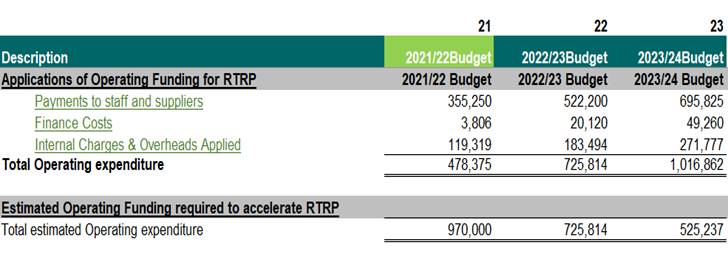
34. Funding for RTRP Opex is
from HBRC reserves. Subject to completion of the final project plan and budget,
it is forecast that up to $500,000 is required to be brought forward from
year-3 to year-1 of the LTP period. Financing this expenditure earlier than
originally budgeted will have little impact when compared with benefits of
achieving increased external investment into planting trees in the RTRP model.
At a 2% finance cost on $500,000 funding brought forward 2 years, the increased
financing cost is approximately $20,000.
35. Timely agreement from
Council for this change in funding will allow staff to work with partners to
confirm the project plan for the 12–15-month accelerated process and
initiate initial work.
Consultation
36. The RTRP funding was
included in the LTP. As this proposal does not seek to change the total
amount of funding allocated to this initiative no consultation is required.
Decision Making Process
37. Council
and its committees are required to make every decision in accordance with the
requirements of the Local Government Act 2002 (the Act). Staff have assessed
the requirements in relation to this item and have concluded:
37.1. The
decision does not significantly alter the service provision or affect a
strategic asset, nor is it inconsistent with an existing policy or plan.
37.2. The use
of the special consultative procedure is not prescribed by legislation.
37.3. The
decision is not significant under the criteria contained in Council’s
adopted Significance and Engagement Policy.
37.4. The persons affected by
this decision are all ratepayers, in relation to the financial impact of the
proposed acceleration of the programme funding.
37.5. Given
the nature and significance of the issue to be considered and decided, and also
the persons likely to be affected by, or have an interest in the decisions
made, Council can exercise its discretion and make a decision without consulting
directly with the community or others having an interest in the
decision.
Recommendations
That the Environment and
Integrated Catchments Committee:
1. Receives and
considers the “Right Tree Right Place Project Acceleration”
staff report.
2. Recommends that
Hawke’s Bay Regional Council:
2.1. Agrees that
the decisions to be made are not significant under the criteria contained in
Council’s adopted Significance and Engagement Policy, and that Council
can exercise its discretion and make decisions on this issue without conferring
directly with the community or persons likely to have an interest in the
decision.
2.2. Approves the request
for a change of timing, with up to $500,000 of expenditure brought forward from
year-3 to year-1 of the approved 3-year LTP budget.
Authored by:
|
Michael
Bassett-Foss
RTRP Project Manager
|
|
Approved by:
|
Ross Franklin
Acting Chief Financial Officer
|
Iain Maxwell
Group Manager Integrated Catchment
Management
|
Attachment/s
There are no
attachments for this report.
HAWKE’S
BAY REGIONAL COUNCIL
Environment and Integrated
Catchments Committee
Wednesday 08 September 2021
Subject: Enviroschools 2020-21
Update
Reason for Report
1. This agenda
item provides an update on Enviroschools in Hawke’s Bay.
Executive Summary
2. Enviroschools
is specifically designed to meet Local Government outcomes including improving
biodiversity, restoring waterway health, reducing waste at school and home,
water conservation, energy efficiency, and resilient and connected communities.
3. The kaupapa of
Enviroschools provides our tamariki with real life natural experiences and
plays a pivotal role in the delivery of environmental education.
4. The programme
has a focus on Learning for Sustainability, Māori
Perspectives, Empowered Students, Sustainable Communities and Respect for the
Diversity of People and Culture.
5. In
Hawke’s Bay, the programme includes exposure to Council activities, such
as the work of the Open Spaces, Biodiversity and Catchment teams, including a
freshwater focus aligned to the TANK Plan.
6. Today we have
68 Hawke’s Bay Enviroschools,
32 ECEs and 36 schools. In recent months we welcomed Ongaonga School to the
programme.
Strategic Fit
7. Hawke’s
Bay Regional Council has supported facilitation of the Enviroschools programme
since 2002.
8. The
facilitation team is well placed to work with schools and their wider
communities to deliver on Regional Council initiatives and campaigns. Currently
we are looking to highlight a Freshwater Focus and our impacts on our Changing
Climate.
9. Enviroschools
programmes support the Regional Council’s strategic focus areas of water
quality, safety and climate-resilient security; climate-smart and sustainable
land use; healthy, functioning and climate-resilient biodiversity, and
sustainable and climate-resilient services and infrastructure.
10. Across Hawke’s Bay,
our Enviroschools continue their involvement in restoration projects.
Throughout winter tamariki have been supporting their local communities. This
has also included growing and planting natives right across our region.
11. We continue to collaborate
with Te Mata Park and have recently been supporting their Kaitiaki programme
involving local schools adopting a section of newly-developed planting areas.
12. This year as part of
Matariki we worked with the Ātea a Rangi Educational
Trust to support their week long schools education programme.
13. We have just appointed a
new facilitator in the Wairoa region, Julia Howard. Julia joins Sonya and Amy
who support our schools in Napier/ Hastings and Central Hawke’s Bay
respectively.
Opportunities for growth
14. A secondary school sector
Climate Action Camp took place in March 2021. We hosted 47 students from seven
different Hawke’s Bay High Schools over two and a half days. The Regional
Council’s wide focus and diverse activities offer so many possibilities
for positive action, we plan to keep the conversation going.
14.1. Specifically following
up and visiting schools that participated in the camp
14.2. Building a stronger base
for our Youth Environment Council.
15. As a result of successful
new funding being approved from the recent Long Term Plan round we will be
boosting our environmental education team. We are looking forward to this role
focusing on the initial priorities of:
15.1. Secondary School sector
– developing stronger relationships to assist field activities; local
curriculum development – including supporting teachers with environmental
NCEA unit standards.
15.2. Scoping out new educational
initiatives that actively engage with the Regional Council’s strategies
and environmental work programmes.
16. I successfully requested
funding from three of our Local Authorities through the Long Term Plan process
in 2021. We are thankful for the continued support of Central Hawke’s Bay
District Council and Napier City Council and welcome back Hastings District
Council as a financial supporter to Enviroschools in the Hastings region. This
is a validation of the work the team carries out and the benefits they see
through Enviroschools supporting their activities, at schools and in the wider
community. This funding will assist with:
16.1. Specific in region
connections, i.e. workshops, resources, professional development opportunities
and supporting our kindergarten partners.
17. Continuing to foster close
contacts with staff at all Hawke’s Bay councils. Regular catch-ups are a
good opportunity to discuss relevant issues and how we can potentially play a
part in solutions at a school and community level.
Summary and next Steps
18. The Enviroschools
programme is highly regarded, however it wouldn’t exist in the
Hawke’s Bay region without the Regional Council’s support.
19. Our local Enviroschools
are well placed to work with us, extending beyond each school into local
communities to tackle challenges head on.
20. Our local focus already
speaks to key catchment-based programmes such as the TANK Plan, with strong
focus on the Karamū and Ahuriri catchments. The facilitation team will
also support the development of local community engagement in the Kotahi Plan
as this work evolves.
Decision Making Process
21. Staff have assessed the
requirements of the Local Government Act 2002 in relation to this item and have
concluded that, as this report is for information only, the decision making
provisions do not apply.
Recommendation
That the
Environment and Integrated Catchments Committee receives and notes the Enviroschools
2020-21 Update.
Authored by:
|
Sally
Chandler
Community Engagement Coordinator (Schools)
|
|
Approved by:
|
Drew Broadley
Marketing & Communications Manager
|
|
Attachment/s
There are no
attachments for this report.
HAWKE’S BAY REGIONAL COUNCIL
Environment and
Integrated Catchments Committee
Wednesday 08 September 2021
Subject: Possum Control Area
Partial Plan Review Update
Reason for Report
1. This item
updates the Committee on the preparation of the proposal
for a partial plan review for the Possum Control Area (PCA) programme staff
were instructed to prepare.
2. The item also
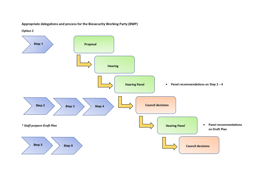
discusses the process for establishing and delegating some partial plan review
decision-making authority to a sub-committee/ Biosecurity Working Party (BWP)
which will also serve as a Hearing Panel during the submission process. A BWP
with appropriate delegated powers will help deliver the partial plan review of
the PCA programme in alignment with the Annual Plan / Long Term Plan amendment
process.
Executive Summary
3. If a
significant change is required to the current PCA programme, a Partial Plan
Review to amend the Hawke’s Bay Regional Pest Management Plan (RPMP)
(under sections 70 to 77 of the Biosecurity Act – the Act) will need to
be undertaken. The steps to ‘making’ a RPMP are clearly
outlined within sections 70 to 77 of the Biosecurity Act 1993. This
includes preparation of a proposal in accordance with the Act, public
notification, receipt of submissions and conducting a hearing process.
4. A final draft
of the amended RPMP, along with a report outlining proposed decisions, will be
tabled for council to make a final decision upon in accordance with section 75
of the Act. Staff will develop the PCA partial plan review proposal over the
next four months and it will be presented to Council early in the new calendar
year.
5. If a
substantive change to resourcing is required to the PCA programme as a result
of the partial plan review process, an amendment to the long-term plan will
also be required to fund it. Consultation would occur concurrently with the
Annual Plan process in March 2022.
6. A key initial
step of the proposal preparation is the Cost Benefit Analysis (CBA) process.
This will require having an indicative range of likely contracting costs for
the contracting out of the PCA programme. It will also require a reworking of
the CBA analysis carried out for the 2019-2039 Regional Pest Management Plan
CBA for possums. Consultants have been appointed to undertake the CBA.
7. Staff
will recommend that at the November EICC a Biosecurity Working Party (BWP) is
established consisting of three appointed Councillors, three appointed members
of the Regional Planning Committee and one independent member with biosecurity
and hearings experience. This panel will hear submissions and can also be
delegated the authority to make certain decisions under the Act. These
delegations will allow for a streamlined, stepped approach, saving Council time
as well as speeding up the hearing process.
Background
8. The
Hawke’s Bay Regional Pest Management Plan is the main statutory document
implementing the Biosecurity Act 1993 in the region; providing a framework for
the management of plant, animal and horticultural pests in Hawke’s Bay.
9. Subsequent to a review of the PCA programme staff were instructed at
the 12 May EICC to prepare a proposal for a partial plan review to consult
publicly on contracting out the delivery of PCA possum control. Staff have
begun preparing the proposal which will require meeting sections 70 - 76 of the
Act. The main requirements of a proposal under S 70 of the Act are outlined in
attachment two for the committee’s information.
10. An
important component of compliance with the Act is a cost benefit analysis (CBA)
and a cost allocation report. The CBA analysis will be undertaken by Jon
Sullivan at Lincoln University and Melissa Hutchison at Tenex consultants. Jon
and Melissa undertook the CBA analysis for the 2019 - 2039 RPMP and have the
appropriate skills and experience for the review of the PCA CBA. Staff are
seeking appropriate consultants to undertake the cost allocation report.
11. Central
to the CBA assessment is the likely cost of contracting out the delivery of
possum control across the region. The actual costs of contracted possum control
cannot be known until (and if) tenders are received from contractors for areas
to receive possum control. However, an indicative range of costs is possible,
and the CBA can be run based on these. A number of factors will drive the cost
of possum control including contract conditions, risk, and the geographic area
possum control is undertaken. Staff will be engaging with possum contractors
who work in the Hawkes Bay region to ensure that the indicative cost range used
in the CBA is realistic.
12. In undertaking the public
notification and receipt of submissions process, as part of the consultation
plan, a hearing panel is required to hear submissions. This panel (the BWP) can
also be delegated the authority to make certain decisions under the Act.
13. The decisions that a
hearings panel can be required to make with delegated authority are:
13.1 Considering and
recommending advice on the PCA partial plan review process and key issues
13.2 Considering reports
on the PCA partial plan review and giving guidance on recommended approach
13.3 Considering reports
on the PCA partial plan review proposal and reviewing and giving guidance on
the proposal and providing guidance on the alignment of the partial plan review
with other plans and strategies
13.4 Reviewing and
giving guidance on received submissions.
14. As shown by the graphic in
attachment one, these delegations to the BWP will allow for a streamlined,
stepped approach, saving Council time as well as speeding up the hearing
process.
15. During the 2019 - 2039
RPMP development, the BWP included one independent, out of region member, with
both Biosecurity and hearings process experience, to sit on the panel as a
Biosecurity expert. This worked well and staff will recommend this take place
for the partial plan review as well.
16. As part
of the 2019-2039 RPMP process, BWP membership included three members each from
the Environment and Integrated Catchments Committee and the Regional Planning
Committee respectively. Staff will be proposing the same membership and
seeking approval for the working party with member nominations at the November
EICC and December RPC.
17. A more
detailed outline of the appropriate delegations and
process for the BWP will be provided initially at the November EICC.
Strategic Fit
18. The
PCA programme sits within the RPMP. The RPMP plays an important role in
achieving both the Biodiversity and Land strategic outcomes and goals in the
HBRC Strategic Pan 2020-25.
19. Failing to achieve the
RPMP objective and council Level of Service Measures for the PCA programme
could affect achieving the strategic outcomes and goals in the HBRC Strategic
Pan 2020-25 for Biodiversity and Land.
Significance and
Engagement Policy Assessment
20. The decision sought in this item is low under the criteria contained
in council’s adopted Significance and Engagement Policy as it is
only seeking to develop a proposal with more detailed information that is to be
subsequently presented to council for consideration and potential public
consultation.
Considerations of
Tangata Whenua
21. Staff consider tangata
whenua will have a strong interest in this topic and will be engaged as part of
the consultation process.
22. If council agree to the
staff recommendation engagement with tangata whenua will occur as part of the
development of the partial plan review process and associated changes to
councils LTP.
Financial and
Resource Implications
23. The average estimated cost
for landscape maintenance control from Hawke’s Bay possum contractors
contacted as part of the PCA review was $7-8/ha. This is acknowledged by
staff as very rough estimate that needs rigorous testing. Staff are now
going through a more detailed contracting cost assessment process as part of
the CBA required under the Act. This information would be included within the
Proposal that would come back to council for consideration before being
released for public consultation.
24. Following
the development of the revised programme and the changes to the levels of
service required for delivery, a change to the Revenue and Financing Policy
will likely be required. The funding needs analysis will be undertaken to
assess the beneficiaries and exacerbators of the revised programme to determine
the most appropriate funding model in accordance with Section 101 (3) of the
Local Government Act.
25. As the
Proposal is highly likely to significantly alter current Levels of Service
consulted on and agreed in the 2021-31 LTP there is likely the need to amend
the 2021-31 LTP and so may necessitate an Annual Plan consultative process
later in 2021/early in 2022 to do this. Staff will provide further advice
on this later in the process.
Consultation
26. A
full consultative process will be undertaken as required within sections 70 to
77 of the Biosecurity Act 1993. This includes public notification,
receipt of submissions and conducting a hearing process.
Decision Making Process
27. Staff have assessed the
requirements of the Local Government Act 2002 in relation to this item and have
concluded that, as this report is for information only, the decision making
provisions do not apply.
Recommendations
That the
Environment and Integrated Catchments Committee receives and notes the “Possum Control Area Partial Plan Review Update” staff report.
Authored by:
|
Campbell
Leckie
Manager Catchment Services
|
Lauren
Simmonds
Project Manager - Biosecurity review
|
Approved by:
|
Iain Maxwell
Group Manager Integrated Catchment
Management
|
|
Attachment/s
|
1⇩
|
Appropriate
delegations and process for the Biosecurity Working Party
|
|
|
|
2⇩
|
Proposal
Requirements
|
|
|
|
Appropriate
delegations and process for the Biosecurity Working Party
|
Attachment 1
|
|
Proposal
Requirements
|
Attachment 2
|
HAWKE’S
BAY REGIONAL COUNCIL
Environment and
Integrated Catchments Committee
Wednesday 08 September 2021
Subject: An Introduction to the
Catchments Policy Implementation Work Programme
Reason for Report
1. This item
provides an overview of the work of Council’s policy implementation
teams, the structural reorganisation that led to development of these teams and
the drivers, focus and priorities of the work.
Executive Summary
2. HBRC has a
Regulatory Policy Implementation team (RI) situated in the Policy and
Regulation Group, and a Catchments Policy Implementation team (CI) situated in
the Integrated Catchment Management Group. These teams work together as a
virtual team and across other sections of council.
3. While this
paper primarily refers to the work in the CI team, it touches on the work in
the RI team.
4. The current
context is one of growing complexity and regulatory requirements for
landowners. This generates potential for confusion and stress in the farming
community.
5. Part of the
role of these teams is to work with other primary sector organisations, rural
professionals and landowner groups (particularly catchment groups) to ensure
clear, consistent and staged messaging to help people navigate a path through
these requirements and to engage with the “why”. The primary reason
for growing requirements is the issues that exist and outcomes needed at the
sub-catchment level.
6. This paper
contains more detail on the work associated with new roles within the team
focused on TANK and Tukituki catchments, as Farm Environmental Management Plan
(FEMP) and Water Efficiency work has been reported to this committee in recent
months.
Strategic Fit
7. The HBRC
Strategic Plan 2020-25 has the mission statement “Enhancing our
Environment Together”. “Together” requires a joined-up
approach across teams within council, and an approach which draws catchment
communities together to strengthen connections to their awa (river) and
collectively work on issues that will improve the health of their catchments.
This builds on the good work done by individual approaches and actions on a
farm by farm basis.
8. The work of CI
connects catchment communities to catchment issues to bring about visible
improvement.
9. The work of the
team is primarily in the Strategic Plan focus areas of land (climate smart and
sustainable land use) and water (quality, safety and climate-resilient
security) and contributes to the following strategic goals and objectives from
the Strategic plan listed below.
Strategic goals
10. By 2050, there is an
increasing trend in the life-supporting capacity of all of the region’s
degraded rivers and major streams.
11. By 2025, Land Use
Suitability information is available to all landowners to inform smarter land
use.
12. By 2025, all farms,
orchards and vineyards operate under a Farm Environment Management Plan or an
independently audited industry best-practice framework.
13. By 2030, all land-users in
critical source areas have phosphorus management plans being implemented, with
at least 50% of highly erodible land treated with soil conservation plantings
14. By 2025, catchment
management plans are established to target improvements on land that lead to
water quality improvements
15. By 2050, there are 50%
less contaminants from urban and rural environments into receiving waterbodies.
Strategic Objectives
16. That Hawke’s Bay
farmers and growers understand their environmental impacts, what they can do to
reduce these, and are implementing good management practice on-farm.
17. That land use is managed
to ensure pathogens and contaminants are being reduced, and water is being
allocated sustainably to highest value use.
Other legislated drivers for the work
Freshwater
Farm plans
18. Resource Management Act
2021 Part 9A outlines requirements for the development of a framework for
Freshwater Farm Plans which will be required nationally.
19. A proposal for a framework
and more detailed regulations to support the development of Freshwater Farm
Plans nationally is currently out for consultation. This proposal includes a
role for council to provide a catchment context to farmers, farm plan providers
and certifiers so that plans can be tailored to address catchment specific
issues.
Tukituki Plan Change 6
20. In 2015 the Change 6 to
the Regional Resource Management Plan (RRMP) for the Tukituki catchment became
operative. This required Farm Environmental Management Plans to be developed
for each farm over 10ha in the catchment by May 2018. There are a range of other
regulatory requirements including thresholds, triggers and dates for requiring
consents, and requirements for stock exclusion from waterbodies.
21. Each regulatory
requirement has needed a program of communication, follow up and coordination
of work across various council teams. This is ongoing.
22. While the plan took a
property specific regulatory approach to set bottom line expectations for stock
exclusion and to manage high instream nitrogen levels in sub-catchments and
individual properties, instream dissolved reactive phosphorus (DRP) is treated
differently as it could not be quantified and managed by rules that seek to
manage phosphorus (P) loss from land at a property scale. P loss still needs to
be managed however, and the Board of Inquiry accepted that managing P loss
required a more flexible farm specific approach requiring farm planning to
address critical source areas on farm for P management.
23. Policy TT5 1.f also
requires HBRC to provide land advisory services and incentives and prioritise
non-regulatory efforts on high P sub-catchments to work with the community and
collaborate with the primary sector. Part of this requires us to encourage
industry good practice and identification of critical source areas to reduce P
loss.
24. Work in priority
sub-catchments (places), with catchment communities (people) to identify
critical source areas and encourage industry good practice and practices that
go beyond regulatory bottom lines will deliver on this policy.
25. Rules and incentives alone
will not be enough to reach the instream DRP targets in exceeding
sub-catchments. Collective catchment engagement and action on the issues is
needed.
TANK Plan Change
26. The
notified draft Change 9 to the RRMP (TANK Plan Change) contains map schedules
of sub-catchment issues and priorities. The proposal developed by the farmer
reference groups for a catchment collective approach had unanimous support from
the TANK stakeholder group. This raised community expectations for HBRC support
for the growth and development of catchment collectives to address
sub-catchment issues. Such support is imbedded in the draft TANK Implementation
plan. The role of council and the form of support is outlined in the 2018
report by Connelly which outlines barriers and risks to adoption of proposed
mechanisms within the TANK Plan Change and focuses particularly on the
requirements for success of catchment collectives. https://www.hbrc.govt.nz/assets/Document-Library/TANK/TANK-Key-Reports/SD-18-007-TANK-Barriers-Report-2018.08.27.pdf
27. The
sub-catchment priorities and the catchment collective approach are unlikely to
change through the remaining TANK hearings process.
Essential Freshwater
package of reforms
28. This
package of reforms was introduced on 3 September 2020. It includes regulations
requiring stock exclusion from water bodies, and National Environmental
Standards (NES) covering a range of other activities such as intensive winter
grazing of forage crops, stock holding areas, land use intensification,
nitrogen fertiliser use.
29. These
requirements require interpretation, clarification and communication to
landowners.
30. The
first requirements of concern to farmers have been those related to intensive
winter grazing (IWG). This is because decision making on crop location and some
management factors are locked in almost a year in advance of the crop being
grazed.
31. Central
government now requires quarterly reporting from regional councils on
monitoring and actions taken in relation to IWG. The first report was 1 August
2021.
Background
Relevant
History
32. The National Policy
Statement for Freshwater Management 2020 (NPS-FM) requires that all councils in
New Zealand must have statutory plans for all catchments notified by the end of
2024.
33. Prior to this requirement
Council had begun a rolling review of the RRMP by catchment. The first of
these catchment-based plan changes to the RRMP was Change 6 to the RRMP for the
Tukituki catchment which was made operative by HBRC in September 2015 and then
required coordinated implementation.
34. Ahead of the first
Tukituki regulatory deadlines in May 2018 the coordination of implementation in
that catchment was largely led by the Land Management team and a “key
practitioners” group within council. In particular, the Land Management team
created an awareness of the Tukituki plan focusing on the priority
sub-catchments and worked with the primary sector and potential farm plan
providers to develop initial processes and external capability for Farm
Environmental Management Plans (FEMPs) to be prepared.
35. Following the 2018 first
regulatory deadlines (requiring FEMPs) there were several changes brought in by
the 2018 HBRC Long term plan (LTP):
35.1. Land Management became
three zone-based Catchment Management teams and refocused on individual farmer
contact in erodible areas of Hawke’s Bay to drive more on-ground erosion
control work to deliver on expectations enabled by the newly established
Erosion Control Scheme
35.2. A project manager role
was created for the FEMP work which was ongoing and needing further
development. This role sat within the client services team alongside Heatsmart
35.3. A Principal Advisor
Policy Implementation role was established in the regulation group to focus on
coordinating implementation of Tukituki regulatory requirements as these became
due.
36. Following a review process
there was a further reorganisation of the Catchment Management team structure
in 2020. Some reasons for this were:
36.1. The work of the Erosion
Control Scheme and erosion control work was the dominant focus of the catchment
teams, and homogenous in its policy and conditions across the region. It
required consistency of processes and efficiency and clarity of approach which
would be best served by a single team in three locations rather than three
teams
36.2. At the same time there
was a recognition of gaps left from the work the Land Management Team had
previously done and an environment of increasing demands and complexity. These
were:
36.2.1. Work required outside
of erodible areas, in the more intensively managed land with water quality
issues other than sediment
36.2.2. Targeted development
and promotion of key good management practices to deal with these other issues
36.2.3. An approach that goes
beyond regulation and individual incentives for on-ground work to bring
catchment communities together to collectively address issues that vary at the
sub-catchment level
36.2.4. A need to provide
support for people to grow understanding, clarity and engagement with catchment
issues and to navigate through the complexity of growing requirements.
37. Since the last catchment
management team reorganisation in 2020 a CI team has gradually been brought
together around this work. There are several connected strands to this work.
The team comprises
38. The 0.4 FTE Water Management
advisor role focused on water efficiency work. Last update on this work was
given to the 12 May 2021 EICC meeting
39. Farm Environment Management Plans (FEMP).
Two roles working on the FEMP project delivery brought across from Client
services team following a review. Last update was given to EICC on 3 February
2021.
40. Two Senior Catchment
Advisor roles that were due in the last LTP, but delayed until February this
year to assist overall HBRC financial conservation in the last financial year.
These roles are focused in the Tukituki and TANK catchments mainly working with
sub-catchment communities.
41. One Science Translator
role presently being recruited and funded from an existing repurposed role.
Regulatory
Policy Implementation work
42. This
connected team comprises of two roles being a Principal Advisor for policy
implementation (in place since 2018) and a Senior Regulatory Advisor (in place
since 2020). These two roles are focused on coordinating cross council
workstreams to ensure the timely implementation of both national and regional
legislative regulatory requirements as prescribed through NES and Regional
plans.
43. The RI
teams internal focus is to ensure that the council has the necessary resources
and processes in place to be able to implement the regulation required by the
Regional Plans, NES and s.360 regulations, as well as ensuring that relevant
staff (mainly regulatory), have an understanding of Council’s obligations
in implementation and receive any required training or upskilling to enable
them to complete their roles successfully. The Senior Regulatory Advisor also
provides technical expertise for the wider regulation group and the FEMP
project team, regarding farm systems and nutrient budgeting.
44. The RI
teams external focus is to ensure that the requirements of Regional Plans, NES
and s.360 regulations are communicated clearly to the affected communities. The
main focus since 2018, has been predominantly in the Tukituki catchment and the
regulatory requirements for FEMPs and production land use resource consents.
This has been achieved by close collaboration with the CI team.
45. When the
TANK plan becomes operative, the RI team will co-lead the internal cross
council implementation team to ensure that the new rules are understood and
communicated to both internal and external stakeholders.
46. Since the
introduction of the NES for freshwater in September 2020, the team has also
been heavily involved in the interpretation of what these new standards will
require from the council and communicating this to both internal staff and
external stakeholders. The team also represents the council on many of the
national working groups established through both MfE and the regional sector to
determine the implications of these new standards and interpret how they will
impact on both council and the communities in our region.
47. As with
the CI team, the RI team has a role to play in the development of Kotahi. As
the plan is developed, the RI team will work with other teams across council to
ensure that the correct processes and resources are in place to successfully
implement the plan and that resources are developed to clearly communicate the
objectives of the plan to the wider community along with any regulatory
requirements.
Discussion
48. As the FEMP and water efficiency work has been reported in
recent months the focus of this discussion will be the catchment work
undertaken by the new roles within the CI team in recent months and the
priorities of this work for the year ahead.
Focus of the
work
Priority places and people - Catchment groups/Collectives
49. Two Senior Catchment Advisor roles are focused in Tukituki
and TANK catchments. In line with the requirements of the Tukituki and TANK
plans outlined earlier there is a focus on supporting the growth and
development of catchment groups. These groups engage catchment communities in
building collective understanding and work within catchments. There are
successful examples of such groups in Hawke’s Bay eg Whangawehi.
50. The starting proposition for HBRC involvement is a group
that is self-motivated, and the aim is to support their development to becoming
self-sufficient. This is a more sustainable model with broader reach than
Council driving group activities. Groups will also be prioritised where their
aims align with HBRC’s, to improve land use or water quality. Catchment
groups commonly form with this aim, but broader social benefits can also occur.
There are also sub-catchment priorities based on current condition.
51. There is currently a growing movement of catchment group
formation across New Zealand. Other agencies such as MPI, Landcare Trust and
Beef and Lamb have an interest in this work. Part of the role of HBRC in
managing relationships with catchment groups is to broker support from other
sources and regional coordination of support from various agencies so that
there is clarity rather than confusion for landowners on available support.
52. The diagram below from Connelly 2018 describes the council
“Catchment Collective” support role required in the TANK
catchments.
53. In particular, recognising and supporting local leadership
development within sub-catchments and providing catchment context will be
important. The Science Translator role will underpin and support the work of
the Catchment Advisors in these catchments by making the resource of HBRC
science information accessible and understandable to landowners at the
sub-catchment level by user testing and adapting the information with catchment
groups.
54. The Science team is currently well focused on supporting
the large amount of policy development work which is underway. The Science
Translator shortcuts that process by taking the issues clearly and directly to
the catchment communities we are working with.
Priority
Practices – Good management practice
55. Some practices have a potential disproportionately large
effect on water quality. A focus on some of these key practice improvements is
another area of focus. Intensive winter grazing (IWG) of forage crops is the
one that is a current focus of work.
Catchment based work
from February to present
Intensive
winter crop grazing
56. A coordinated IWG campaign has been designed and delivered,
with communications through various media and field-days and coordination and
reporting of activities to central government. There were 9 field-day, group
presentations, or catchment group sessions presented on this across the region
to communicate expectations for winter crop management. There was a joint
approach to these field days with other primary industry groups and vets to
include animal welfare messages were covered.
Catchment
group work
57. The team has made a good start since February, connecting
with and offering support to the various catchment groups in Tukituki and TANK
catchments and across the rest of the region. This has also involved working with
and supporting groups in erodible areas with existing relationships to the
catchment delivery team. Support has included sessions on a range of topics
requested by the groups and sessions to help clarify and agree on purpose at
the formation stage.
58. A stocktake of these groups contacted show 26 groups across
the region at various stages of development from expressing an interest in
formation to well-formed with a legal structure in place such as an
incorporated society. There are currently 6 groups in TANK out of 41
sub-catchments and 7 groups in Tukituki out of 17 sub-catchments.
Priorities for
the year ahead 2021-22
Practices
59. IWG work to continue with a further campaign of delivery
through the season to support farmers with clear information at key decision
times. This links IWG with developing national freshwater farm plan
requirements.
60. Development of a project focused on nitrogen management in
arable systems in the TANK area in collaboration with industry stakeholders.
Catchments
61. Continue development of support packages for catchment
group startup, growth and development. These will include workshops, training
and access to information.
62. Begin a programme across TANK subcatchments, raising
awareness of subcatchment priority issues, TANK plan and the catchment
collective opportunity. There will be a pilot project supported by the Science
Translator with two subcatchments to develop, test and refine communication of
subcatchment issues. This will then be replicated for other sub-catchments.
Provision of catchment context material is also a proposed requirement for
regional councils in the current national freshwater farm plan documentation.
The Science Translator will focus on developing supporting material in TANK
catchments in the first year before moving on to other areas.
63. Build a network structure between catchment groups within
major catchments and regionally to bring catchment group leaders together to
create an accelerated learning environment for catchment group development. The
first workshop is scheduled for 21 September.
64. Begin developing a relationship between catchment groups
and a Tukituki reference group to gain feedback on implementation
effectiveness.
Work with
implementation partners
65. Both implementation teams (Catchments and Regulatory) will
work with rural professionals, primary sector industry bodies and organisations
to ensure alignment and work to resolve issues so that landowners receive clear
and consistent messages to help navigate a path through requirements. A Pan
Primary Sector group will be re-formed to assist this.
Ongoing plan
development
66. Connection and contribution to Kotahi plan development to
ensure plan is able to be implemented.
Next Steps
67. Future delivery of
catchment-based plans will present growing needs for internal and external
coordination of catchment place-based implementation. The need for this overall
coordination of TANK implementation as that plan comes on stream has been
recognised across HBRC teams with identified responsibilities in the TANK draft
implementation plan. There is a position for an overall TANK project
coordinator in year 3 of LTP to deal with that.
68. Action
plans – The National Policy Statement for Freshwater Management (NPSFM)
2020 recognises that catchment-based plans need to be implemented and put into
action. This signals a future requirement for more tangata whenua and community
involvement and ownership in development, review and improvement of these
implementation plans which are labelled “action plans”. Staff
are exploring ways that this can be achieved. What can be signalled is
that in future, the development of, and then implementation of Kotahi will
require more dedicated internal and external coordination.
Decision Making Process
69. Staff have assessed the
requirements of the Local Government Act 2002 in relation to this item and have
concluded that, as this report is for information only, the decision making
provisions do not apply.
Recommendation
That the
Environment and Integrated Catchments Committee receives and notes the “An Introduction to the Catchments Policy Implementation Work
Programme” staff report.
Authored by:
|
Louise
McPhail
Principal Advisor (Policy Implementation)
|
Brendan
Powell
Manager Catchments Policy Implementation
|
|
Kate Proctor
Senior Regulatory Advisor
|
|
Approved by:
|
Katrina
Brunton
Group Manager Policy & Regulation
|
Iain Maxwell
Group Manager Integrated Catchment
Management
|
Attachment/s - There are no
attachments for this report.
HAWKE’S
BAY REGIONAL COUNCIL
Environment and Integrated
Catchments Committee
Wednesday 08 September 2021
Subject: Tukipo Wetland
Reason for Report
1. This item
provides an update on the successful delivery of the 1.6ha constructed wetland
in Tukipo following Hawke’s Bay Regional Council committing $100,000 of
the Recovery Fund to this project in the 2020-21 financial year.
Background
2. Ambitious
nitrogen targets have been set in the Tukituki Plan, and in some cases require
instream Dissolved Inorganic Nitrogen (DIN) levels to be more than halved.
3. Fonterra
included the Tukipo catchment to be part of their Sustainable Catchments
programme, due in large part to proactive work from the Tukipo Catchment Care
Group (TCCG). The Tukipo sub-catchment was sitting at 2.32 mg/l, which is
almost 3 times over the 0.8 mg/l DIN target and indicated a 66% reduction in
instream DIN levels would be required.
4. Ongoing
research has proven the effectiveness of constructed wetlands at removing
nitrogen from waterways via biological conversion (microbial denitrification)
rather than plant uptake. This confirms that a strategic network of constructed
wetlands, in combination with on farm improvements around nutrient management,
may help achieve the ambitious nitrogen reduction targets.
5. The Council
Tukituki implementation team believe that constructed wetlands may form a key
part of the strategic Tukituki response, and are very supportive of the
constructed wetland initiative. It is hoped that the outcomes from this project
will provide a model that is transferable to other properties in Hawke’s
Bay. A well-designed constructed wetland that is sized to 1% of the catchment area
can remove 20-30% of the nitrogen passing through it.
6. Fonterra
provided HBRC and the TCCG funding to undertake a scoping exercise to identify
willing landowners who had suitable sites to build a constructed wetland to
achieve DIN reduction on a catchment scale ($30k). A further $226k was then
provided to design and construct a wetland on the most promising site.
7. Over this same
time period, NIWA obtained funding from MPI’s Sustainable Land Management and Climate Change: Freshwater
Mitigation Fund to comprehensively monitor 6 constructed wetlands to
collect high quality data to refine our understanding on wetland performance
and help improve the wetland modules available in Overseer or for use in other
nutrient modelling approaches. The two projects aligned and so NIWA designed
the Tukipo wetland so that it could be used in their national project.
8. Following
completion of the scoping exercise a preferred location was selected that had
full support from the landowner to construct a 1.6ha wetland to capture and
treat water from a 180ha catchment. The wetland was designed larger than
originally expected in order to meet requirements for inclusion in the national
NIWA study.
9. To fit in with
project timelines and due to COVID-19 lockdown in 2020 preventing site visits,
the wetland design work had to be completed remotely and was based off LiDAR
(remote sensing using pulse lasers to measure elevation) which gave the most
accurate data set available at the time.
10. Prior to construction
beginning the design was double checked with a surveyor building a 3D model for
machinery to run off. However, this process revealed that the LiDAR data
underestimated the volume of earth that needed to be moved. This resulted in
the construction costs increasing to exceed the available budget.
11. A decision was made to
proceed with the construction to meet project timeframes. This meant the
wetland earthworks would be completed within available budget, but the site
could not have been planted with the correct wetland plants needed to ensure a
highly functioning constructed wetland in time to be part of the NIWA
monitoring project, unless additional funding as obtained.
12. To fill the budget gap, a
paper was successfully presented to the Corporate and Strategic Committee on 3
March 2021 seeking $100k to be committed from Councils $1m Recovery Fund to
allow for the complete delivery of this project to ensure the wetland could be
created within the timeframes needed for inclusion into the NIWA national
monitoring programme.
13. Prior to this decision the
constructed wetland project had been exclusively funded by Fonterra (approx.
$250k), with Council only committing a small amount of staff time.
Councils’ investment provided an opportunity to further collaborate with national
organisations to lead and deliver an exciting research and development project.
The results of which could provide a model that would add significant value to
how we target nitrogen reduction throughout the region and provide a more
holistic understanding of the water quality benefits derived from wetlands. It
would also provide a local farm feature for the Tukituki community to consider.
Discussion
14. Construction of the
wetland was completed in May 2021 which included the planting of approximately
24,000 native wetland plants. Further details on the development of the wetland
will be presented during the Environment and Integrated Catchment Committee
meeting.
15. A successful planting day
was held involving Tukipo Catchment Care Group and a range of HBRC from
Regulation, Consents/Compliance and Catchment Delivery.
16. HBRC Comms Team prepared a
media release covering the successful delivery of the project that highlighted
the collaborative approach between key organisations and landowners to
investigate possible solutions to current water quality issues. This was
covered by multiple radio and print media as well as TVNZ One News and included
staff/landowner interviews. The landowner has welcomed multiple calls from
other interested farmers based on his interview.
17. NIWA are committing their
expertise and the equipment required to continuously monitor flow, nitrate,
turbidity and floods, alongside covering the laboratory costs for monthly monitoring
at the wetland inflow and outflow for three years with monitoring set to begin
late summer. The expectation is that a well-designed wetland that is sized to
1% of the catchment area can remove 20-30% of the nitrogen passing through it.
18. The
collaborative approach taken to deliver this project has helped build and
strengthen relationships with rural landowners in the region, creating positive
solution focused discussions about how to improve water quality.
19. Hawke’s Bay region
has a paucity of functioning wetlands and the establishment of this new wetland
will also be of significant value to the region for biodiversity through
increased habitat.
Next Steps
20. Regional Councils and NIWA
are exploring how best to provide nitrogen credits to farmers who are using
constructed wetlands to help meet their nitrogen reduction targets.
21. Fonterra are interested in
committing further funding for projects targeting water quality improvement in
the Tukituki catchment. We are currently in discussions around funding a
scoping exercise for the entire Ruataniwha Plains, using Lidar and land use
layers to identify optimum areas for locating catchment scale constructed
wetlands for Nitrogen stripping. This approach will seek to identify the best
locations for a strategic network of constructed wetlands of various sizes on
both private and HBRC owned land.
Decision Making Process
22. Staff have assessed the
requirements of the Local Government Act 2002 in relation to this item and have
concluded that, as this report is for information only, the decision making
provisions do not apply.
Recommendation
That the
Environment and Integrated Catchments Committee receives and notes the
“Tukipo Wetland” staff report.
Authored by:
|
Dr Andy Hicks
Team Leader/Principal Scientist Water
Quality and Ecology
|
Thomas Petrie
Programme Manager Protection &
Enhancement Projects
|
Approved by:
|
Iain Maxwell
Group Manager Integrated Catchment
Management
|
|
Attachment/s
There are no attachments
for this report.
HAWKE’S BAY REGIONAL COUNCIL
Environment and
Integrated Catchments Committee
Wednesday 08 September 2021
Subject: Update on the 3D
Aquifer Mapping Project (SKYTEM)
Reason for Report
1. This
item provides the Committee with an
update on the progress of the 3D Aquifer mapping project, including revisiting
the objectives and outcomes sought, timeframes, budgets and partners
involved. It also provides an overview of the data collected, the analysis
undertaken and presents some of the preliminary findings
Executive Summary
2. The Hawke’s Bay 3D Aquifer Mapping
Project (3DAMP) is a three-year initiative (2019-2022) jointly funded by the
Provincial Growth Fund (PGF), Hawke’s Bay Regional Council (HBRC) and GNS
Science (GNS). The project applies Airborne Electromagnetic surveys (SkyTEM)
technology to improve mapping and modelling of groundwater resources within the
Heretaunga Plains, Ruataniwha Plains and Poukawa and Otane Basins. 3DAMP
involves collaboration between HBRC, GNS and the Aarhus University
HydroGeophysics Group (HGG). The programme is also supported with specialist
project management services from Project Haus.
3. Between Jan/Mar 2020, SkyTEM were flown
over the Heretaunga Plains, Ruataniwha Plains and Poukawa and Otane Basins by
SkyTEM Australia. Within Heretaunga and Ruataniwha Plains, work is currently
underway to collect additional geological data for model calibration through an
exploratory drilling programme. Completion of this work is planned in
stages based on the areas surveyed.
4. GNS Science have completed processing and
modelling of SkyTEM data in the Poukawa and Otane Basins. This work involved
removing data impacted by electromagnetic noise, developing resistivity models,
and interpreting basin-wide hydrogeological characteristics. Work is underway
to develop similar models within the Heretaunga and Ruataniwha Plains. This
report provides an update on these work programmes.
Strategic Fit
5. This work underpins actions and outcomes
listed in the 2017-2021 Strategic Plan as things that council will continue to
do; and will do differently.
Water Quality,
Safety and Uncertainty. Kia kounga, kia haumaru, kia pumau te pai o te wai
6. Aquatic ecosystems are protected and
enhanced for all to safely enjoy, and all water users have knowledge on what
water is available to meet their needs
6.1. Land use is managed to ensure pathogens
and contaminants are being reduced, and water is being allocated sustainably to
highest value use
6.2. Identify/protect Hawke’s Bay’s
outstanding freshwater bodies
6.3. Better understand trends/risks for each
catchment
6.4. Work with stakeholders in high-risk areas
to design viable solutions
6.5. Ensure efficiency of water use
6.6. Investigate alternative sources.
Smart,
Sustainable Land Use. Kia koi, kia ukauka te whakamahinga o te whenua
7. Focus on managing the effects of intensive
land use/irrigation.
8. The proposal also links to Sustainable
Services and Infrastructure in relation to:
8.1. transforming natural resources to economic
prosperity; along with
8.2. providing regional leadership and
enhancing relationships and partnerships (especially with identification of
safe drinking water supplies).
9. Drivers include the NPS-FM and objectives
set in RRMP Tukituki Plan Change 6, along with the proposed TANK plan change 9.
Background
10. The concept of using SkyTEM to map regionally significant
groundwater resources was proposed by HBRC Staff during development of the
Heretaunga groundwater model. This led to discussions between the GNS Science
and Council on the potential application of airborne electromagnetic (AEM)
technology for groundwater mapping.
11. In 2017, following discussions with GNS Science, a proposal
for an AEM survey was presented to Council as part of Science’s business
case for the Long-Term Plan (LTP). This business case proposed to deliver a
high-resolution geophysical dataset for the entire Heretaunga Plains aquifer
system. At the request of the Council this was extended to include the
Ruataniwha Basin and was adopted in the 2018-2028 Long-Term Plan.
12. In 2018 and 2019, HBRC engaged GNS Science and Project Haus
Limited to carry out planning for the SkyTEM survey and to develop a strategy
for all tasks required for processing, modelling, and interpretation of SkyTEM
data, including refinement of groundwater knowledge and information (such as refining
geological and groundwater models).
13. During 2019, with assistance from GNS Science and Project
Haus Limited, HBRC applied to the Provincial Growth Fund (PGF) for additional
funding. The application included surveying the Poukawa and Otane Basins in
addition to the Heretaunga and Ruataniwha Plains. This was notified as
successful in June 2019. In October 2019, SkyTEM Australia Pty Ltd was
contracted by HBRC to acquire AEM data using SkyTEM technology. This survey was
flown during January and February 2020.
14. GNS Science have completed processing and modelling of SkyTEM
data in the Poukawa and Otane Basins. This work involved removing data impacted
by electromagnetic noise, developing resistivity models, and interpreting
hydrogeological characteristics for the groundwater resources. Work is underway
to develop similar models within the Heretaunga and Ruataniwha Plains.
15. A programme of work is planned to update the Heretaunga
numerical groundwater models based on the hydrogeological frameworks derived
from interpretation of the AEM data. SkyTEM data is currently being used to map
the base of the aquifer in the Bridge Pa area, as part of model developments
for the Te Whakaheke o Te Wai programme.
16. The AEM data, combined with existing borehole data, provides
considerable improvement in understanding of the hydrogeologic framework
at a level of accuracy not previously achievable. Such refinements aim to
expand the utility of predictions made using numerical groundwater models
and provide water-resource managers with increased knowledge upon which their
decisions are based.
Objectives and
benefits of SkyTEM
17. The primary objective of the 3D aquifer
mapping project is the provision of improved scientific data and information,
leading to accurate and reliable groundwater management decisions. This
information is vital to ensure the health and well-being of groundwater
resources are protected (including surface water connections), drinking water
is safe, and users have confidence in the reliability of water supply.
18. Airborne Electromagnetic data is needed to
help understand the location, extent, and physical properties of
hydrogeological layers (i.e., aquifers and confining layers). The
hydrogeological framework is a fundamental source of information for
quantitative and qualitative groundwater analysis. Poorly conceptualised
settings based on limited knowledge of the hydrogeological framework can lead
to incorrect parameterisation and erroneous or misleading model predictions,
and ultimately sub-optimal groundwater management decisions.
19. The hydrogeologic framework for most
groundwater analysis is traditionally based on lithological (description of the
geological properties) borehole logs, however, scarcity of lithological logs
(particularly at depth or over difficult terrain) and low-quality of logging
means existing information is often missing or insufficient to fully capture
regional and local-scale geological structures. This, coupled with the high
cost associated with drilling and high cost of professionally logging
exploration wells, means characterising groundwater systems with a dedicated
drilling programme is neither practical nor feasible.
20. Airborne Electromagnetic data provides a
cost-effective, non-invasive data collection method to map large areas with a
higher density of data coverage and the ability to cover areas with rugged
terrain with minimal impacts to local activities.
21. The Hawkes Bay Regional Council has
invested significant amount of staff time and cost into development of
numerical groundwater models for the Heretaunga and Ruataniwha Plains. Results
of these models underpin policy developed for Plan Change 9 and Plan Change 6
respectively. Understanding the complex groundwater and surface water
interactions in the Heretaunga and Ruataniwha Plains has allowed managers to
develop defensible and sound policy in support of these plan changes.
Furthermore, simulation of management scenarios, aimed at balancing demand
for water supply with impacts on the environment, were critical in setting
allocation limits.
Who’s
involved?
22. The 3D Aquifer Mapping Project is a
three-year initiative (2019–2022) jointly funded by the Provincial Growth
Fund (PGF), HBRC and GNS Science (GNS). The project applies SkyTEM technology
to improve mapping and modelling of groundwater resources within the Heretaunga
Plains, Ruataniwha Plains and Poukawa and Otane Basins. This project involves
collaboration between HBRC, GNS Science and the Aarhus University
HydroGeophysics Group (HGG). The programme is also supported with specialist
project management services from Project Haus.
Budgets and funding
23. The budget for the 3D Aquifer mapping
project is $4.86 million (Table below). This includes costs for the SkyTEM
survey, additional data collection, such as drilling, resistivity and
geological modelling, and refinement of the Heretaunga numerical groundwater
model. Provision is made for all services and works within the Council’s
Long-Term Plan. This project is funded through a combination of capital loan
funding, general rates, GNS in-kind contributions and PGF funding.
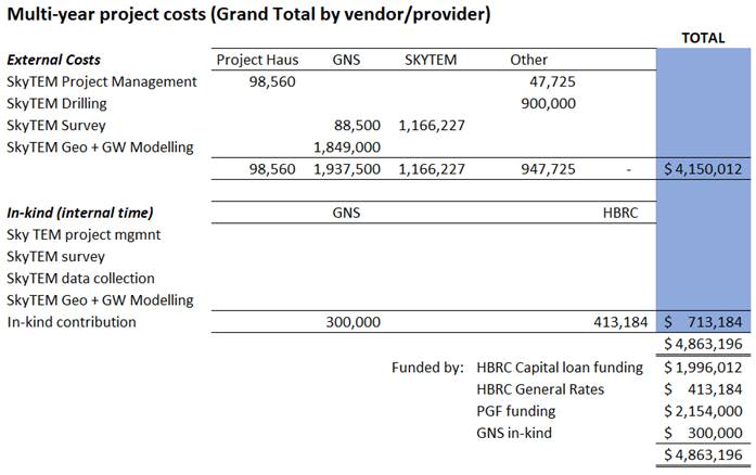
Discussion
Summary of SkyTEM survey and current
results
24. In October 2019, SkyTEM Australia Pty Ltd was contracted by
HBRC to acquire airborne electromagnetic (AEM) data using SkyTEM technology.
This was flown using helicopter during the period 12 January to 10 February
2020 using a New Zealand company Heli A1 Limited.
25. The survey acquired 7,786 kilometres of transient
electromagnetic (TEM) and magnetic data. The Heretaunga surveys delivered
2,540.5km of data along transects spaced approximately 170 metres apart. The
Ruataniwha survey delivered 3884.2km of data along transects spaced
approximately 250 metres apart. The Poukawa survey delivered 1220 km of data
along transects spaced 200 metres apart. A further 69.6km of data was collected
offshore spaced 400m apart.
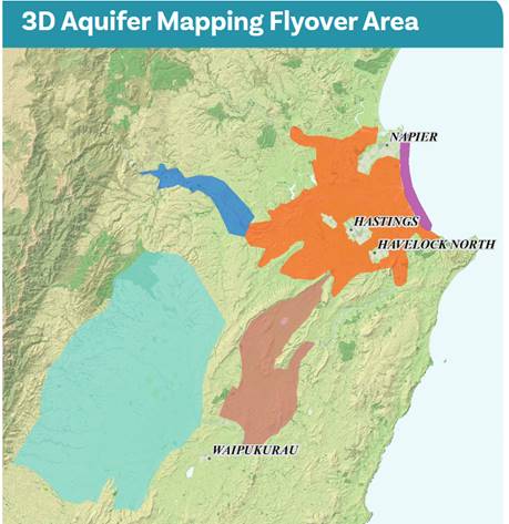
26. GNS Science have finalised processing and
resistivity modelling for the Poukawa and Otane Basements and are working on
finalising interpretations from this data set. The SkyTEM survey reveals a
detailed 3D resistivity picture of the subsurface which in some locations
extends down to 490 metres below land surface.
27. The resistivity data has been used to
delineate the Poukawa and Otane basins into three major hydrogeological units
(HU) of which two of these units are further split into two hydrogeological
subunits (sub-HU). The delineations enable a view of the subsurface geology and
hydrogeology not previously possible and provide significant refinement of the
existing understanding of groundwater resources in the Poukawa and Otane
basins. These hydrogeological units will be demonstrated during the meeting.
Summary of the work programme
28. The work programme for the 3D Aquifer
Mapping project commenced September 2019 and completion is planned for December
2022. Key milestones are:
28.1. Complete airborne electromagnetic surveys
of the Heretaunga, Ruataniwha and Otane/Poukawa aquifer surveys (completed)
28.2. Develop quality assured resistivity models from the collected
SkyTEM data (Work In Progress - WIP)
28.3. Undertake a simple groundwater-relevant
assessment of the resistivity models for Heretaunga Plains, Ruataniwha Plains
and Otane/Poukawa Basin (WIP)
28.4. Complete a more complex
groundwater-relevant assessment of the resistivity models for Heretaunga Plains
and Ruataniwha Plains considering factors such as confinement status and
groundwater-surface water interaction (i.e., clay fraction models) (WIP)
28.5. Develop Geological Models using the
resistivity data and interpretations for Heretaunga Plains and Ruataniwha
Plains, for the purposes of visualisation, conceptual understanding of the
aquifer systems and for informing groundwater flow models (WIP)
28.6. Refine existing Numerical Groundwater
Models using the resistivity data and interpretations for Heretaunga Plains
(WIP).
Next Steps
29. Multiple workstreams are underway including:
29.1. An additional data collection programme – exploratory
drilling and ground-based Transient Electromagnetic (TEM) Surveys are being
used to constrain resistivity inversions and assist with secondary
interpretations. This programme of work is nearing completion with exploratory
drilling remaining for one site in the Ruataniwha Plains.
29.2. GNS Science are processing and modelling the resistivity data
for the Heretaunga Plains survey area. A draft report on these findings is
expected in September for staff review.
29.3. The 3D aquifer mapping project team (HBRC/GNS Staff and
Project:Haus) have been developing a communication strategy for delivering 3D
aquifer mapping products, this includes:
29.3.1. Developing a ESRI StoryMap to present
findings from resistivity modelling and secondary interpretations, explain
concepts related to the methods of data collection, provide links to reports
and to provide updates on the project. HBRC are looking to use a similar
StoryMap template as used by the USGS for the Mississippi1
29.3.2. Continuing with quarterly newsletter
reports to interested stakeholders
29.3.3. Capturing digital media such as drone
footage and interviews explaining the data collection methods and modelling
29.3.4. Exploring online options for visualising
and interrogating resistivity data and interpretations. Staff have held
discussions with two providers of geological modelling software and GNS Science
are developing a prototype portal using the Poukawa data set as an additional
third option.
Decision Making Process
30. Staff have
assessed the requirements of the Local Government Act 2002 in relation to this
item and have concluded that, as this report is for information only, the
decision-making provisions do not apply.
Recommendation
That the
Environment and Integrated Catchments Committee receives and notes the
“Update on the 3D Aquifer Mapping Project (SKYTEM)” staff report.
Authored by:
|
Simon Harper
Senior Scientist
|
Dr Jeff Smith
Manager Science
|
Approved by:
|
Iain Maxwell
Group Manager Integrated Catchment
Management
|
|
Attachment/s
There are no
attachments for this report.
HAWKE’S BAY REGIONAL COUNCIL
Environment and
Integrated Catchments Committee
Wednesday 08 September 2021
Subject: Update on the Whakaheke
o Te Wai (TWOTW): MBIE Funded Endeavour Programme and Heretaunga Plains
Groundwater Case Studies
Reason for Report
1. This item provides the Committee with an overview
on the progress of this programme, including revisiting the objectives and
outcomes sought, timeframes, and partners involved. It also provides an
overview of the data collected, the analysis undertaken and present some of the
preliminary findings.
Executive Summary
2. The Te Whakaheke o Te Wai (TWoTW) research
programme is a 5-year programme (2018-2023) funded through the Ministry of Business,
Innovation and Employment (MBIE) aimed to better support water
management-decisions based on an improved understanding of groundwater flow
sources, pathways, and time-lags. The programme seeks to incorporate
groundwater age and isotope tracers, surface and groundwater
mātauranga Māori (Māori knowledge), and other data into numerical models, which are developed across a
range of scales. The programme is led by GNS Science in collaboration with
national and international organisations and key stakeholders.
3. The Heretaunga Plains is a critical case study
for this programme and is being used to develop understandings and
methodologies for groundwater system that will be extended across New Zealand.
Key partners in the Heretaunga Plains case study include HBRC, Ngāti
Kahungunu, and Hastings District Council.
4. Beyond the Heretaunga Plains, the programme is
undertaking a nationwide sampling programme of groundwater age tracers and
isotope tracers. The programme is also developing a national groundwater age
model based on this nationwide sampling programme. Methods and tools to allow
rapid, robust, and cost-effective building and deployment of groundwater models
are also being developed.
5. To date the programme has sampled isotope,
dissolved gas, and the hydrochemistry signature of surface water and
groundwater within the Heretaunga Plains. This work is to refine the
understanding of groundwater recharge sources, and the flow system throughout
the Plains.
6. As part of the TWoTW programme, five different
groundwater models are in the process of development within the Heretaunga
Plains, each with a different modelling purpose, e.g., development of methods
for incorporating new information from new data sources, such as SkyTEM,
isotope data, mātauranga knowledge,
etc. Models are also being used to test how this new information can be
used to support:
6.1. groundwater allocation limit setting
6.2. groundwater source protection zone delineation
6.3. estimates of lags between land use change and
water quality changes
6.4. providing a numerical voice to local concerns,
and
6.5. hypothesis testing.
7. All the model development is being undertaken in
a Bayesian context, where the uncertainty of specific predictions is quantified
and reduced to the extent that available data allows.
8. An archive of mātauranga Māori in the
plains is being compiled. This is focusing on identifying the long-term
changes in the groundwater-surface water system of the Heretaunga Plains area.
To date this work has centred around identification and mapping of features and
indicators that hold significance to local iwi.
Strategic Fit
9. This work
underpins actions and outcomes listed in the 2017-2021 Strategic Plan as things
that council will continue to do; and will do differently:
Water Quality, Safety and Uncertainty. Kia kounga, kia
haumaru, kia pumau te pai o te wai
10. Aquatic ecosystems are
protected and enhanced for all to safely enjoy, and all water users have
knowledge on what water is available to meet their needs
10.1. Land use is managed to
ensure pathogens and contaminants are being reduced, and water is being
allocated sustainably to highest value use
10.2. Identify/protect
Hawke’s Bay’s outstanding freshwater bodies
10.3. Better understand
trends/risks for each catchment
10.4. Work with stakeholders
in high-risk areas to design viable solutions
10.5. Ensure efficiency of
water use
10.6. Investigate alternative
sources.
Smart, Sustainable Land Use. Kia koi, kia ukauka te
whakamahinga o te whenua
11. Focus on managing the
effects of intensive land use/irrigation
12. The proposal also links to
Sustainable Services and Infrastructure in relation to:
12.1. transforming natural
resources to economic prosperity; along with
12.2. providing regional
leadership and enhancing relationships and partnerships (especially with
identification of safe drinking water supplies)
13. Drivers include the NPS-FM
and objectives set in RRMP Tukituki Plan Change 6, along with the proposed TANK
plan change 9.
Overview of progress to date
14. New data from the
Heretaunga Plains has been gathered and already enabled unprecedented new
understanding of groundwater flow boundaries, recharge source,
river-groundwater interaction, flow velocities, and mātauranga o te wai,
and is being used to improve groundwater-surface water models. The next
steps in the project will see this enhanced understanding through analysis of
groundwater age tracer data and mātauranga Maori to be rolled out NZ-wide.
Modelling work components that are currently underway to support this are
further summarised below.
15. National-scale groundwater
model of New Zealand (using MODFLOW 6) developed in conjunction with the NZ
Water Model project (NZWaM), is incorporating nationally consistent datasets
and providing seamless coverage of groundwater flow information across NZ. It
also provides the foundation for the national groundwater age map and serves as
an optimal starting point for the rapid generation of regional and local scale
models that can be modified to address specific questions in areas of interest.
16. Our existing Heretaunga
Plains groundwater model has been updated into the new MODFLOW 6 software
platform, in collaboration with HBRC, allowing 'communication' between the national
and local models and information transfer through aquifer model
boundaries. The Heretaunga Plains model also serves for testing a range
of methodologies developed to enhance the model-based assimilation of
information from groundwater age and other tracer data, as well as the SkyTEM
survey data.
17. Development of local
groundwater models focussing on the area around Bridge Pa, with the aim of
combining groundwater modelling and mātauranga Māori to give a
numerical voice to the concerns of the community, and to explore how community
observations of long-term changes in the groundwater system can reduce the
uncertainty of predictions used to underpin water management decisions.
The methodology for this work combines five main components.
17.1. gaining an understanding of the nature of community concerns
surrounding groundwater and surface water
17.2. research into the long-term changes in the groundwater and surface
water system
17.3. collating all available long-term and recent data to form a conceptualisation
of the groundwater-surface water system, and building a numerical model on this
basis
17.4. undertaking history matching, predictive simulations, uncertainty
quantification analyses, and exploring the extent to which key predictions are
reduced by the information in different data
17.5. exploring the feasibility of mitigation options in the context of the
understanding of the system encapsulated in the model, while acknowledging the
remaining uncertainties.
18. Development of new
efficient and robust approaches for source protection zone modelling addressing
two fundamental problems.
18.1. Up-scaling (coarse approximations) of small-scale sedimentary features
(e.g. open framework gravels) that dominate transport problems
18.2. Identifying simple and robust source protection zone delineation
methods without exaggerating land required, nor underestimating risk to health,
for a range of hydrogeological and water supply contexts.
19. Develop meta-modelling
approaches for the Heretaunga Plains by using statistical relationships between
groundwater age and other groundwater parameters, such as, distance to the
coast, hydrochemistry, geology, etc to provide estimates of groundwater age in
unsampled parts of aquifers. These approaches are currently being tested
and developed using data sets from several regions.
20. A database of surface
water and groundwater Mātauranga observations that span both space and
time has been developed, including a spring stocktake whereby all known springs
have been accurately mapped and identified. This has also involved archival
research, working with early maps of the area located at the MTG (Napier
Museum), as well as those created for the Māori Land Court hearings in the
1870s. This information is supported by aerial photographs, oral
histories, and collectively provides a record of observed behaviour and
long-term changes in the groundwater and surface water system.
Who’s involved?
21. The TWoTW is collaborating
with a number of national and international organisations and key stakeholders[1].
22. The 3D Aquifer Mapping
Project (reported separately to this meeting) is providing information on the
aquifer basement, and hydraulic properties for use in the models being
developed. As more information comes available from the 3D Aquifer Mapping
project further refinements may occur.
Budgets and funding
23. The Te Whakaheke o Te Wai
(TWOTW) research programme received $9.5 million from the MBIE Endeavour Fund.
HBRC provides in-kind contribution via data collection programmes and modelling
support.
Decision Making Process
24. Staff have assessed the
requirements of the Local Government Act 2002 in relation to this item and have
concluded that, as this report is for information only, the decision-making
provisions do not apply.
Recommendation
That the
Environment and Integrated Catchments Committee receives and notes the “Update
on the Whakaheke o Te Wai (TWOTW): MBIE Funded Endeavour Programme and
Heretaunga Plains Groundwater Case Studies” staff report.
Authored by:
|
Simon Harper
Senior Scientist
|
Dr Catherine
Moore
PRINCIPAL GROUNDWATER MODELLER –
GNS SCIENCE
|
|
Dr Jeff Smith
Manager Science
|
|
Approved by:
|
Iain Maxwell
Group Manager Integrated Catchment
Management
|
|
Attachment/s
There are no
attachments for this report.
HAWKE’S BAY REGIONAL COUNCIL
Environment and Integrated
Catchments Committee
Wednesday 08 September 2021
Subject: Update
on IRG Flood Control Resilience Funded Projects
Reason for Report
1. This report
provides an update on the four projects approved for funding as part of the
Crown’s Flood Control Resilience Funding with the Infrastructure
Reference Group managed by Kānoa – Regional Economic Development
& Investment Unit, formerly known as the Provincial Development Unit.
Background
2. Council
has received IRG funding for a total amount of up to $19.2m (plus GST, if any)
which is a 64% contribution to four projects.
3. Works commenced on all four projects in late November 2020.
Discussion
Project
1: Heretaunga Plains
Flood Control Scheme (HPFCS) Levels of Service - $20m
4. The HPFCS
Levels of Service project will review and upgrade sites across the Tūtaekurī,
Ngaruroro, Lower Tukituki and Clive rivers, to increase flood protection across
the scheme to a 1 in 500-year event.
5. This project is
programmed over a three-year with IRG funding but will carry on after this
period and will build upon existing river modelling, condition assessment and
property analysis undertaken as part of the Heretaunga Plains Flood Control
Scheme level of service review.
6. HBRC co-funding
of $7.2 million is required to match IRG funds of $12.8 million.
7. Prioritisation
of 39 stop bank sites is being established by Asset Management based on
freeboard levels, risk of overtopping, consequence of failure and value of
assets protected. Sites are being assessed in order of priority and at least 8
sites will be upgraded through the course of this project. Assessment and
upgrade of remaining sites will continue beyond the 3-year programme.
8. HBRC has
commenced works on the priority sites and 3 sites are in advanced phases with
Taradale being designed by HBRC and consultants engaged to undertake
investigation for Ngatarawa and Roy’s Hill. Consultants are being
appointed for further 2 sites, based on HBRC’s Panel for Engineering
Services which will be fully established mid-September.
9. To date, works
completed are:
|
Site Name &
Location
|
River
|
Works Completed
to Date
|
Proposed
Works**
|
|
Taradale Stopbank
Strengthening (XS 17 - 22 LHS)
|
Tūtaekurī
|
Archaeology assessment,
geophysical testing, Geotechnical investigation, Topographical survey,
Preliminary Design
|
Increase height of
stopbank for overtopping, increased width of stopbank,
|
|
Moteo Stopbank
Strengthening (XS 43b - 47 RHS)
|
Tūtaekurī
|
Archaeology assessment,
geophysical testing, Geotechnical investigation scoping, Topographical survey
|
TBC pending output from
geotechnical testing and ground model
|
|
Omaranui (XS 23-41 RHS)
|
Tūtaekurī
|
Archaeology assessment,
Topographical survey
|
Increase height of
stopbank for overtopping
|
|
Haumoana Stopbank
Strengthening (XS 1 - 4 RHS)
|
Lower Tukituki
|
Archaeology assessment,
Geotechnical investigation scoping, Topographical survey
|
Increase height of
stopbank for overtopping
|
|
East Clive Stopbank
Strengthening (XS 1 - 4 LHS)
|
Lower Tukituki
|
Archaeology assessment,
Geotechnical investigation scoping, Topographical survey
|
Increase height of
stopbank for overtopping
|
|
Pakowhai Park (XS 15-20
RHS)
|
Ngaruroro
|
Geophysical testing,
Topographical survey
|
|
|
Raupare Lower (XS 20-27
RHS)
|
Ngaruroro
|
Geophysical testing,
Topographical survey
|
|
|
Ngatarawa (XS 49 - 51
RHS)
|
Ngaruroro
|
Archaeology assessment,
Geotechnical investigation underway, Topographical survey
|
|
|
Roy's Hill (XS 41 - 44
RHS)
|
Ngaruroro
|
Archaeology assessment,
Geotechnical investigation underway, Topographical survey
|
|
|
Meeanee d/s motorway
(XS 13-17 LHS)
|
Tūtaekurī
|
Topographical survey
|
|
|
Haumoana Upstream of
Blackbridge (XS 4 - 10 RHS)
|
Lower Tukituki
|
Archaeology assessment,
Topographical survey
|
Increase height of
stopbank for overtopping
|
|
Farndon Road Erosion
|
Clive
|
Works scoped for
Engineering Panel
|
Scour protection to
Farndon Road
|
**
Subject to outputs from site investigations, geotechnical modelling and any
additional hydraulic modelling
10. Another key part of work
in FY 2020-21 was engagement of an ecologist to provide a biodiversity
management plan and increase biodiversity at key sites, initial plans have been
developed for Taradale, Moteo, Ngatarawa, Roy’s Hill and East Clive
berms. This work maintains a link with proposed Public Use of Rivers (PUR)
project.
11. HBRC have committed to
deliver eight stop bank strengthening projects over the three-year period
through IRG funded works. Further, by undertaking integrity investigations of
similar or higher priority sites in tandem, HBRC provides confidence in the
resilience of our flood protection assets and thus achieve the objective of
increasing climate resilience of HPFCS systematically. Should these
investigations lead to physical work requirement, this will add to the below
list.
|
Year
|
Committed Projects
|
|
1
|
Taradale Stop Bank
(earthworks, stop bank upgrade, PUR)
|
|
1
|
Moteo Stop Bank (berm
improvement – groynes or strategic planting; earthwork requirement
being assessed as part of design)
|
|
1/2
|
East Clive (stop bank
upgrade required following overtopping assessments; landfill on riverside
presented additional challenges)
|
|
2
|
Clive River @ Farndon
Road (erosion protection - potentially sheet piling)
|
|
2
|
Omarunui (stop bank
upgrade required & archaeological complications being worked through)
|
|
2
|
Haumoana (stop bank
upgrade required & archaeological complications being worked through)
|
|
2/3
|
Pakowhai Park
(earthworks, stop bank upgrade, PUR)
|
|
3
|
Haumoana upstream of
Blackbridge (earthworks, stop bank upgrade)
|
12. FY 20-21 expenditure was
$832k against a projection of $944k.
13. The estimated value of FY
2021-22, 2022-23 and 2023-24 planned works is $10.68 million, $4.62 million and
$3.9 million respectively. In 2021-22 this includes stop bank
strengthening construction works on two sites (Taradale and East Clive),
detailed design of five sites (based on results from geotechnical
investigations), commencement of investigative work on further six sites.
14. FY 2022-23 planned works
includes stop bank strengthening construction works on at least further four
sites, detailed design of two sites (based on results from geotechnical
investigations) and completion of environmental enhancement of 5 sites.
15. FY 2023-24 planned works
includes stop bank strengthening construction works on at least further two
sites and completion of environmental enhancement of 3 sites. The Upper
Tukituki (UTT) Gravel Extraction project will seek opportunities to subsidise
gravel extraction from this scheme with a focus on competitive tendering and
supporting the local economy. Gravel extraction is required to maintain
existing nameplate capacity of 1:100 level of protection within this scheme.
Project 2: Upper Tukituki
Gravel Extraction Flood Control Scheme - $8 million
16. The Upper Tukituki (UTT)
Gravel Extraction project will seek opportunities to subsidise transportation
of gravel from this scheme with a focus on competitive tendering and supporting
the local economy. Gravel extraction is required to maintain existing
nameplate capacity of 1:100 level of protection within this scheme. As a consultation
topic in the 2020 Long Term Plan, Council agreed to fund the HBRC
co-contribution of $2.88m from the UTT scheme through a long term loan allowing
the project to proceed.
17. HBRC have engaged a
consultant to assist with Expressions of Interest (EOI) which will form a
pre-qualification for extraction contractors to tender on reaches for
extraction. The EOI shall provide contractors with testing data and
prioritisation maps in order to confirm industry’s demand for gravel
extraction volumes both locally and further afield and give context to
timeframes. It is expected that the EOI data will dictate a detailed extraction
programme based on industry demand.
18. EOI’s are expected
to be sent out to industry late September with contract documentation to be finalised
within the same timeframe. Contracts for extraction and gravel removal
partially funded under the IRG programme anticipated in October 2021 for a
period of 25 months.
19. To date, HBRC has
completed:
19.1. Gravel material testing
programme - results will be made available to all tenderers as part of the EOI.
This information has been requested and shared with several local contractors
and is generally available upon request prior to submission of the EOI
19.2. Prioritisation of key
reaches – Determined on the following criteria: Freeboard (related to 100
year flood risk), Average annual flood risk (related to availability), Lateral
erosion risk. This allows extraction to focus on areas which are critical to
the flood protection of the UTT scheme
19.3. Availability of gravel
– based on prioritisation, data to be provided as part of EOI to
tenderers and shall assist with programming. This data has also been shared
with local contractors, upon request, following the last public meeting
19.4. Identification of
additional access – HBRC Schemes Team assisting with landowner
discussions for critical accesses
19.5. Request for Information
from industry – 17 submissions received relating to cost for extraction
and transportation. This data will underpin the project’s rationale for
reasonable subsidised costs, specifically relating to transportation of
material
19.6. Public meetings with
both ratepayers and contractors to provide updates on project status.
Contractor representation at public meetings was attended by small and medium
sized local businesses as well as larger businesses from out of the region.
HBRC have also met on site with a small local contractor to better understand
their business and how they might support any potential Chilean Needle Grass
(CNG) studies
19.7. Assessment of known
archaeological assessment sites – Working with New Zealand Archaeological
Association (NZAA) to map known sites on HBRC GIS with buffer zones based on
site type
19.8. Liaison with HBRC
Biosecurity and AgResearch to scope a testing programme to manage CNG within
the UTT scheme. Works are likely to benefit out with this programme and
external funding is being considered to achieve successful outcomes
19.9. Met with both Heretaunga
Taiwhenua and NKII and discussed a permanent HBRC “Kaitiaki” role
funded by for supervision of the works.
20. FY 2020-21 expenditure was
$298,000 and FY 2021-22 costs are estimated at $2.99 million.
21. In FY 2022-23 costs for
gravel extraction are estimated at $4.712 million.
Project
3: Upper Tukituki Flood Control Scheme SH50/Waipawa Erosion - $1 million
22. This one-year project
provided engineered erosion protection works on the right and left bank of the
Waipawa river, immediately upstream of SH50 bridge.
23. To complete the project,
HBRC Works Group installed 75 precast concrete akmon units on the left bank of
the Waipawa river, carried out earthworks to cut and fill gravel to form the
new river channel, including excavation, carting and shaping approximately 70,000m3
of gravel, and installed 3,166 lineal metres of rail irons and 8,100 lineal
metres of wire rope to form permeable groynes on the left and right banks.
24. An independent ecological
impact assessment undertaken at the site concluded that the completed project
has resulted in an overall net positive effect on biodiversity.
25. The planting of 4,700 pole
trees in the berm area and a further 1,000 native trees was undertaken in
partnership between Kaitiaki Rangers (Waiohiki Marae) and Works Group. Training
and upskilling was provided to the Kaitiaki Rangers on this collaborative
project which has received positive feedback from Kānoa due to HBRC
fulfilling its social procurement outcomes to engage and upskill Māori/Pasifika
businesses.
26. Project completion was
completed at a total value of $1.25 million.
Project 4: Wairoa River, River Parade Erosion - $1
million
27. This one-year project
programme will provide steel sheet piled erosion protection works on left bank
of the Wairoa River.
28. Geotechnical
investigations, design optioneering and preliminary design and detailed of the
proposed sheet pile wall have been completed and the physical works contractor
has procured the necessary steel sheet piles to enable a Mid-September start
date (notwithstanding further delays from COVID).
29. The relocation of the
Wairoa District Council watermain has been completed in collaboration with
Wairoa District Council
30. The proposed steel sheet
piled wall is 73 lineal metres with 12 metre screw anchors which are drilled
below the existing River Parade Road.
31. The local civil
engineering contracting company Lattey’s Civil and Precast have been
appointed to as main contractor with Wairoa based QRS providing sub-contracting
services relating to civil works.
32. Planting of the upstream
riverbank with the appropriate trees and bush will provide stability to the
rivers edge whilst also contributing to the biodiversity of the river. This
will allow safe access for the public to the river’s edge and popular whitebating
(Inanga) area.
33. HBRC have been engaging
with local groups Tātau Tātau o Te Wairoa Trust, Wairoa Reserves
Board – Matangirau (WRB) and Wairoa District Council to identify the
aspirations and requirements of this project on the cultural values to the region.
HBRC are in the process of undertaking a cultural impact assessment of the
local Iwi groups, as well as an assessment of environmental impacts on the
fish, birds and plants of the river and surrounding area.
34. FY 2020-21 expenditure was
$98k, and FY 2021-22 costs are estimated at $902k.
Decision Making Process
35. Staff have assessed the
requirements of the Local Government Act 2002 in relation to this item and have
concluded that, as this report is for information only, the decision making
provisions do not apply.
Recommendation
That the
Environment and Integrated Catchments Committee receives and notes the “Update
on IRG Flood Control Resilience Funded Projects”.
Authored by:
|
Martina
Groves
Manager Regional Assets
|
David
Keracher
Manager Regional Projects
|
Approved by:
|
Chris Dolley
Group Manager Asset Management
|
|
Attachment/s
There are no
attachments for this report.
HAWKE’S BAY REGIONAL COUNCIL
Environment and
Integrated Catchments Committee
Wednesday 08 September 2021
Subject: Public Use of Rivers
Reason for Report
1. In February
2019, a paper “Management of Public use of river berm lands update”
was presented to the Environment and Services Committee advising of updating
the investigation into Management of Public Use of River Berms (PUR) within the
Heretaunga Plains Flood Control Scheme.
2. The purpose of
this paper is to provide an update to the Committee on progress and next steps.
Our intent is that this project will partly integrate with the Heretaunga
Plains Flood Control Scheme Level of Service (HPFCS LoS) upgrade work co funded
by the Covid Recovery Infrastructure Reference Group fund.
Executive Summary
3. In
2016 HBRC undertook a review of how its key river corridors are managed, and
how our management obligations and their use by the public can be best
accommodated. This was in response to increased expectations by the community
in regard to the provision of space for recreational activities and the effects
associated with those activities. In particular, how Council balances such
effects with their other management responsibilities such as flood protection
and biodiversity outcomes.
4. The
primary goal of this project was to explore various management and maintenance
methods for the river corridors and a review of existing and potential public
use activities. The report would then provide provision of guidance on the most
appropriate management methods and outline a long term plan for management.
5. An
analysis report was prepared in 2018 which identifies:
5.1. Existing
activities that are undertaken in the rivers
5.2. Effects
associated with public use and access
5.3. Preliminary
assessment of methods that could be employed to manage such effects
5.4. Preliminary
assessment of potential capital projects to enhance and develop such areas.
6. The
Asset Management Group has already implemented some changes to existing
practice, for example:
6.1. Grazing
has been reduced and other activities trialed and changed to mowing or
planting. No grazing on the Karamū Stream
6.2. Widespread
trials have been conducted on the Ngaruroro including hay bailing in areas
above Chesterhope Bridge and increased planting (native) on the right bank
above the SH2 bridge and Chesterhope Bridge
6.3. A
portion of the right bank of the Ngaruroro has been retired between Fernhill
Bridge and the mouth and grazing has ceased here
6.4. Ongoing
planting with different natives and exotics to enhance biodiversity value
6.5. Restricted
vehicle access to some reaches of the river to decrease rubbish dumping and
vandalism.
7. The
PUR project has been put on hold after the adoption of the report in 2019 due
to:
7.1. Insufficient
detail of the HPFCS LoS project in identifying the improvements required to
deliver a resilient scheme to a 1:500 year of projection. This is to ensure
that the primacy of the scheme is maintained and informs the PUR work. This
will assist in minimizing an inefficient use of capital.
7.2. It
has been identified that no comprehensive iwi engagement had been undertaken
and a consultation has only taken place with existing recreation groups.
Effective iwi consultation was required to inform the PUR project in terms of
sites of importance, iwi culture and aspirations.
8. When the HPFCS
LoS project was accelerated due to IRG funding in November 2020, the PUR
project was identified as the key component to inform the project of likely
future use of any component of the scheme that was upgraded. HBRC commenced
work to develop a consultation document. This document (attached to the paper)
has been developed to better understand the values people associate with the
rivers, concerns people may have about the use of rivers and aspirations for
future use.
9. It is noted
that some consultations have already commenced as part of the ongoing planting
and flood protection work with different iwi groups and other river users (4W
drivers club, motocross club, BMX users).
10. As part of this work we
are identifying known culturally sensitive sites. The project team has mapped
all known sensitive cultural sites and engaged an archaeologist to work with us
through the project planning.
11. A planting strategy has
also been commenced to identify not only how to enhance biodiversity on the
berm areas but also to look into options of commercial forest planting which
will have potential benefit in the future for carbon credit and also additional
income for the scheme.
12. The project area being
considered for both LoS and Public Use of rivers are:
12.1. Tūtaekurī
River – priority area as per attached map
12.2. Ngaruroro River –
priority areas as per attached map
12.3. Lower Tukituki River -
priority areas as per attached map.
13. The project is restricted
to the land that is owned and manged by the Council. It does not cover any
privately owned land.
14. High level planning for
some of the river access points as part of the Level of Service upgrade work is
now underway with consultation to be scheduled prior construction.
15. The final PUR report will:
15.1. identify a long term
strategy for managing our river berms for scheme requirements, cultural,
biodiversity and recreational outcomes
15.2. Provide a recommended
30-year capital investment plan to deliver 15.1
15.3. Provide a recommended
30-year operational budget to deliver 15.1.
Background
16. HBRC’s Asset Management Group is responsible for managing the
flood protection schemes including access points and public spaces within the
scheme areas. There are existing issues of vandalism, antisocial behaviour,
rubbish dumping, undesirable vehicle use, freedom camping and illegal or
antisocial activities have been ongoing for too long and appear to be
escalating. These issues often involve health and safety matters as well as
environmental damage, at an increasing cost to ratepayers.
17. In December 2016, a paper
and report “Review of use of Heretaunga Plains Scheme River Berm
Land” was presented to the Environment and Services Committee advising of
an investigation into Management of Public Use of River Berms within the
Heretaunga Plains Flood Control Scheme followed by an update to the 13
September 2017 meeting on investigations to understand and / or respond to:
17.1. Perceived declining
regional community tolerance over some aspects of river berm management, such
as berm grazing.
17.2. Increasing community
level of service expectations as berm land has become both more accessible
through higher public use such as cycle trails and more visible due to
expressway developments.
17.3. Pressures on scheme land
area to accommodate new activities and infrastructure such as horse trails,
jet-ski/ boat ramps, carparks and sports grounds whilst not compromising flood
protection services and the continued opportunity for existing public use and
activity.
17.4. Inappropriate public use
and activity such as rubbish dumping, vehicle hooning, freedom camping and
illegal activity.
17.5. The need to consider the
above in the context of multiple use opportunities such as flood control and
drainage objectives, iwi aspirations, biodiversity and ecological enhancements.
18. There are various Māori
accounts regarding naming, settlement and use of the awa. This stage of the
project is to engage with iwi to enrich understanding of the cultural values
and find ways in which to celebrate and share appropriate cultural histories.
Discussion
19. The next step of this
project seeks to achieve the following key outcomes:
19.1. Enhance the
understanding of cultural values and history
19.2. Engaged coordinator to start
the process on engaging with mana whenua
19.3. Work with mana whenua to
understand their aspirations for this area
19.4. Focus on the priority
areas and integrate this project with Level of Services review (IRG).
Next Steps
20. To optimise the use of
capital the Asset Management Group intends to integrate outcomes of the PUR
project into HPFCS LoS program. This will coordinate deliverables of both
programmes at key prioritised sites, identified as part of the IRG funded
projects.
21. Key outcomes are also to:
21.1. Enhance the
understanding of cultural values and history
21.1.1. Work with mana whenua
and archaeologists to map significant sites
21.1.2. Incorporate existing
Hapu management Plans into this project
21.1.3. Invite input from iwi
and hapu into priorities managing the HPFCS that reflects the culture and
aspirations of iwi
21.1.4. Develop opportunities
for education celebrate appropriate cultural history.
22. The next steps are Iwi
engagement and public consultation.
23. Focused early consultation
for specific sites may be led through HPFCS LoS upgrade projects and later
incorporated into the greater PUR project.
Decision Making Process
24. Staff have assessed the
requirements of the Local Government Act 2002 in relation to this item and have
concluded that, as this report is for information only, the decision making
provisions do not apply.
Recommendations
That the
Environment and Integrated Catchments Committee receives and considers the
“Public Use of Rivers” staff report and supports the staff
proposal to proceed with the iwi consultation with the assistance of the Māori
Partnerships group.
Authored by:
|
David
Keracher
Manager Regional Projects
|
Martina
Groves
Manager Regional Assets
|
Approved by:
|
Chris Dolley
Group Manager Asset Management
|
|
Attachment/s
|
1⇩
|
Public Use of
Rivers Consultation Document
|
|
|
|
2⇩
|
Executive
Summary - Review of Public Use of Rivers - February 2018
|
|
|
|
3⇩
|
Map - HPFCS -
LoS Priority Areas
|
|
|
|
Public
Use of Rivers Consultation Document
|
Attachment 1
|
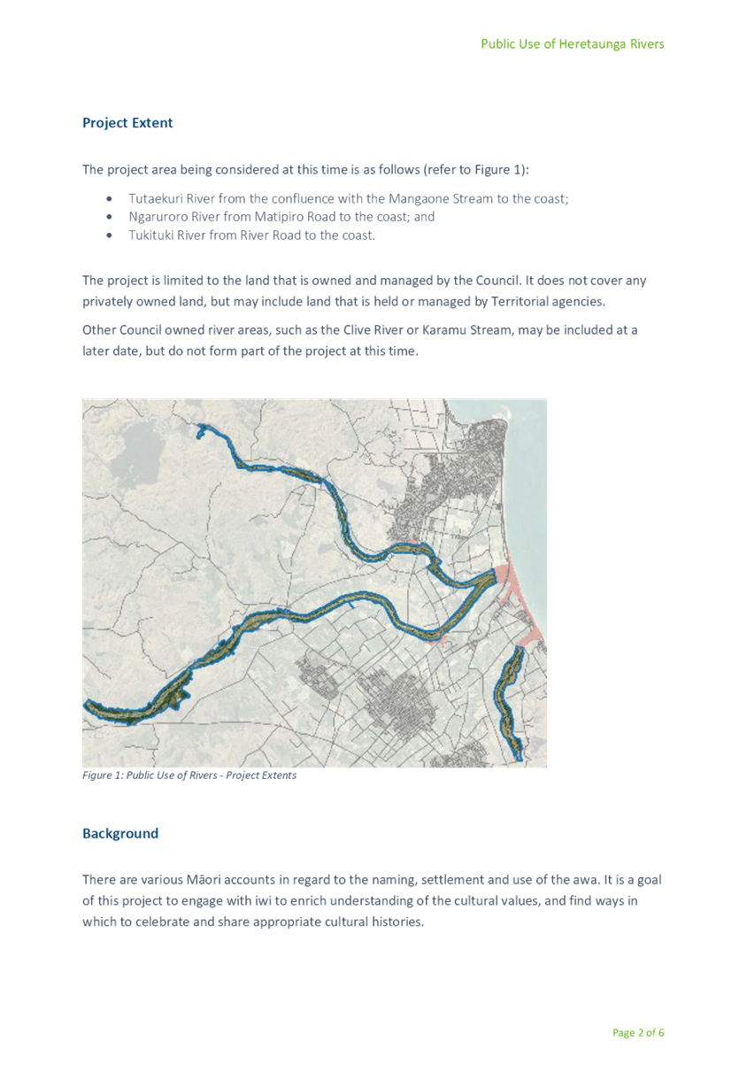
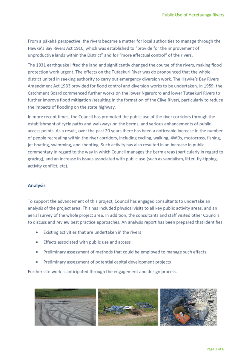
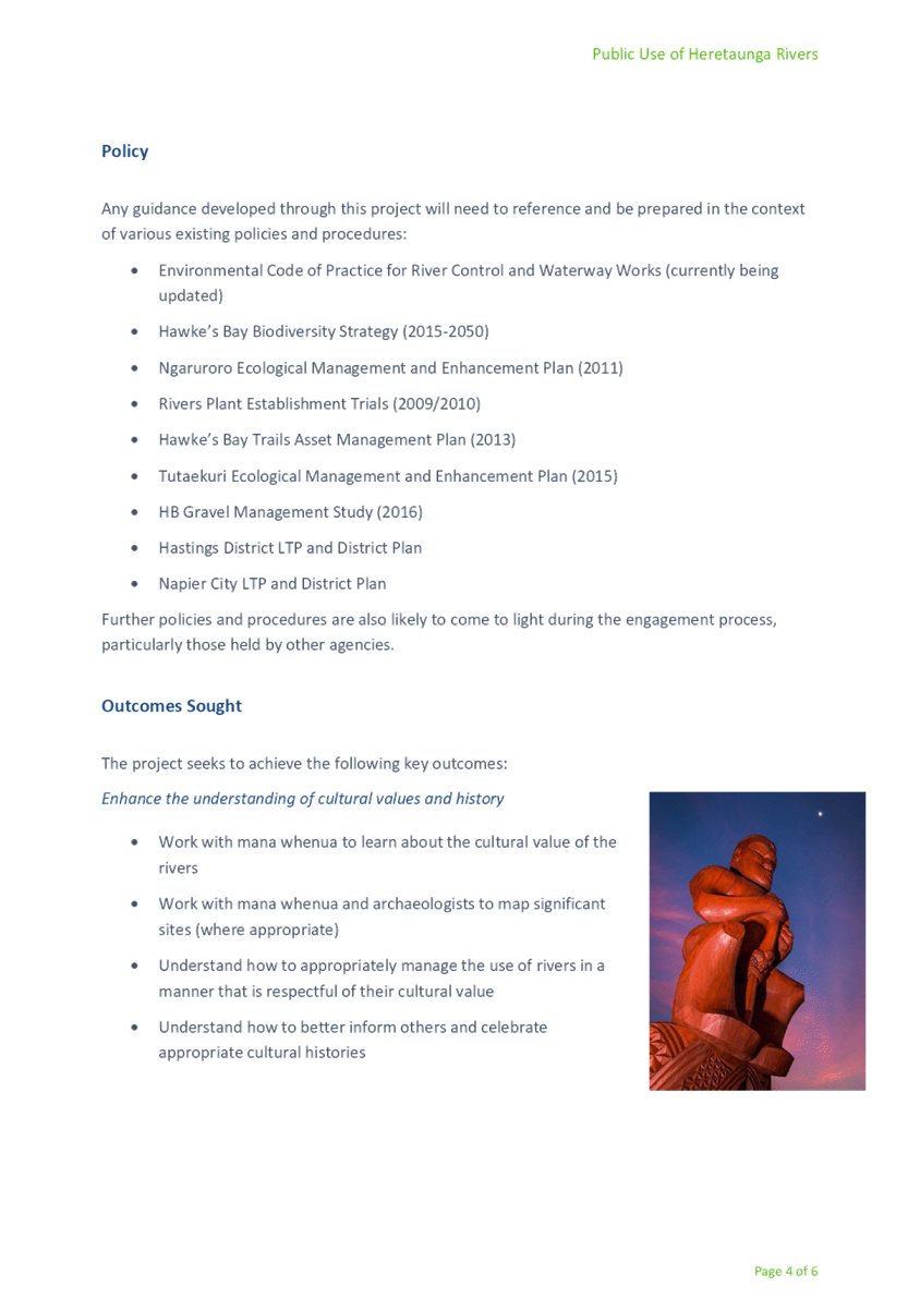
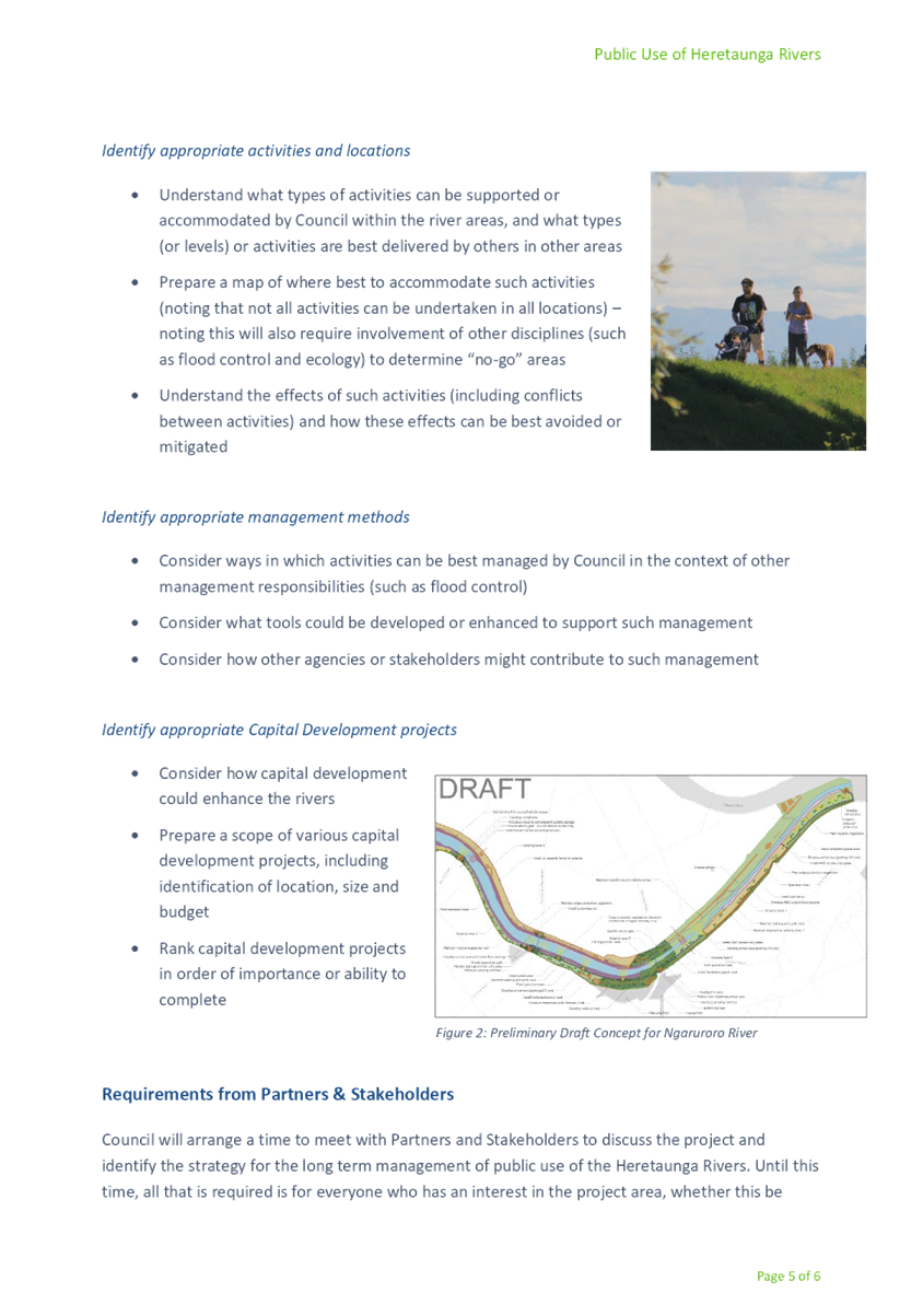
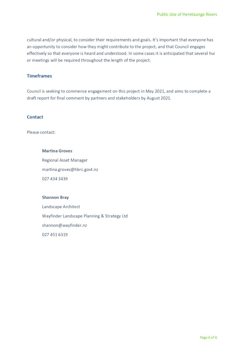
|
Executive Summary - Review
of Public Use of Rivers - February 2018
|
Attachment 2
|
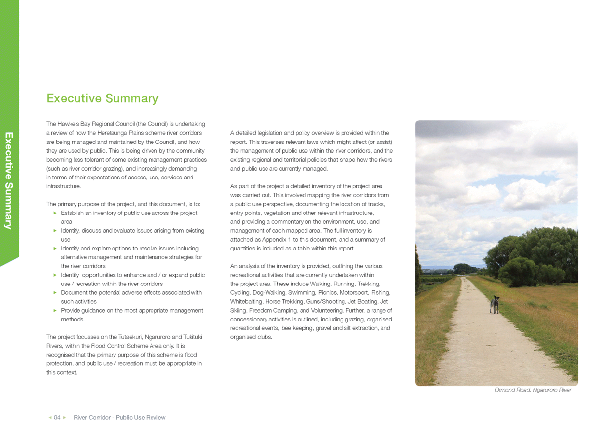
|
Map - HPFCS - LoS Priority
Areas
|
Attachment 3
|
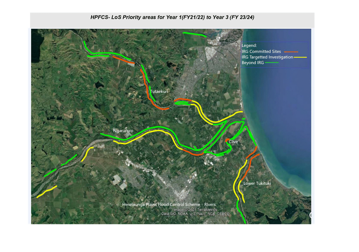
HAWKE’S BAY REGIONAL
COUNCIL
Environment
and Integrated Catchments Committee
Wednesday 08 September 2021
Subject: Call for Certificate of
Appreciation Nominations
Reason for Report
1. To call for nominations by Committee members, for HBRC environmental
certificates of appreciation.
Background
2. At its meeting on 24 April 2018, the Regional Council resolved:
2.1. Creates three categories for nomination to recognise environmental
stewardship, being:
2.1.1. Environmental
Leadership in Business – Te Hautūtanga Taiao me te Pakihi:
Recognises businesses or local authorities that demonstrate kaitiakitanga,
innovation or efficiency, or an ongoing commitment to environmental best
practice.
2.1.2. Environmental Leadership in Land Management – Te
Hautūtanga Taiao me te Whakahaere Whenua:
Recognises land users who are committed to environmental stewardship and
sustainability in their meat, fibre, forestry or other land use operations.
2.1.3. Environmental
Action in the Community – Te Oho Mauri Taiao ki te Hapori:
Recognises not-for-profit organisations or individuals that are taking action
to protect or enhance the environment, or are increasing understanding of
environmental issues.
2.2. Calls for nominations to the above categories from Councillors at
the Environment and Services Committee held in September each year, with the
Award being presented to the recipient at the November or December Regional
Council meetings with a morning or afternoon tea event.
3. The awards were initiated as a result of councillors’ desire
to recognise valuable contributions to environmental enhancement by people and
organisations in the community in a semi-formal manner as
‘nominated’ by councillors themselves. Past recipients, by way of
example, include:
3.1. Forest
& Bird Hastings and Napier for Environmental
Action in the Community in recognition of their involvement in and sponsorship
of community and HBRC led planting events, in particular, riparian planting at
Pekapeka and along the Karamu Stream
3.2. Bostocks for Environmental
Leadership in Business in recognition of planting carried out along the Karamu
as well as leadership of the GMO Free Hawke’s Bay movement
3.3. James
Hunter for Environmental Leadership in Land Management in recognition
of his protection of 51 hectares in QEII Covenants, including
9ha wetlands and regenerating bush/scrublands that would have been lost without
intervention. He was also recognised for representing farmers as a member of a
group involved with the Massey University award winning study on getting
farmers to understand and adopt the newest ideas and innovations from
agricultural science, as well as the Huatokitoki Landcare Community Project
“Creating a climate for successful catchment management”.
3.4. Jill Snelling for Environmental
Leadership in Land Management, in recognition of her work turning her farm into
a reserve with minimum use of chemicals and a reliance on the old ways of doing
things, willingly sharing her knowledge with others and welcoming groups to
gather heirloom seeds/seedlings from her property, as well as supporting the
Wairoa nursery project.
1.1. Karituwhenua
Reserve Trust received the certificate of appreciation for Environmental
Action in the Community in recognition of a long history of
work stretching back to 1992, planting trees, enhancing the reserve area around
the Karituwhenua stream and encouraging birdlife, creating pathways and
addressing erosion issues.
Next Process Steps
4. The proposed process leading to the awarding of Certificates is that:
4.1. Councillors email any nominations, including full details of the
initiative and supporting information, location, award category and person or
group/organisation being nominated, to Peter Martin, Senior Governance Advisor,
by 4pm on Thursday 30 September 2021.
4.2. Nominees’ details, including reasons for the nomination and
award category, will be collated as an agenda item for councillors’
consideration, discussion, and resolution of award winners in public excluded
session at the Regional Council meeting on 27October 2021.
4.3. Successful award recipients will be invited to the 15 December 2021
Regional Council meeting for formal awarding of certificates.
Decision Making
Process
5. Staff have
assessed the requirements of the Local Government Act 2002 in relation to this
item and have concluded that, as this report is for information only, the
decision making provisions do not apply.
|
Recommendation
That the Environment and Integrated
Catchments Committee receives and considers the “Call for
Certificate of Appreciation Nominations” staff report and requests
that Councillors endeavour to provide nominee details as requested, to Peter
Martin by 4pm on Thursday, 30 September 2021.
|
Authored by:
|
Leeanne
Hooper
Team Leader Governance
|
|
Approved by:
|
Desiree Cull
Strategy & Governance Manager
|
|
Attachment/s
There are no
attachments for this report.
HAWKE’S BAY REGIONAL COUNCIL
Environment and
Integrated Catchments Committee
Wednesday 08 September 2021
Subject: Discussion of Minor
Items not on the Agenda
Reason for Report
1. This document has been prepared to assist
Committee Members note the Minor Items Not on the Agenda to be discussed as
determined earlier in Agenda Item 6.
[1] Primary
collaborators: National Institute of Water and Atmospheric Research
(NIWA, NZ), Institute of Environmental and Scientific Research (ESR, NZ), Te
Tai Whenua O Heretaunga (Hawke’s Bay, NZ), Victoria University of
Wellington (VUW, NZ), Watermark Numerical Computing (AUS). Additional
collaborators: Hawke's Bay Regional Council (HBRC, NZ), Environment
Canterbury Regional Council (ECan, NZ), Monash University (AUS), University of
Saskatchewan (CAN), Luxembourg Institute of Science and Technology (LUX),
Hastings District Council (HDC, NZ), Hawke’s Bay District Health Board
(HBDHB, NZ), Ministry for the Environment (MfE, NZ), Ngāti Kahungunu Iwi
Incorporated (NZ),