Meeting of the Regional Planning Committee
Date: Wednesday 21 September 2016
Time: 10.00am
|
Venue:
|
Council Chamber
Napier City Council
Hastings Street
NAPIER
|
Agenda
Item Subject Page
1. Welcome/Notices/Apologies
2. Conflict
of Interest Declarations
3. Confirmation of
Minutes of the Regional Planning Committee held on 3 August 2016
4. Matters Arising
from Minutes of the Regional Planning Committee held on 3 August 2016
5. Call for any Minor
Items Not on the Agenda 5
6. Follow-up Items
from Previous Regional Planning Committee Meetings 7
Decision Items
7. Regional Planning
Committee Activity Annual Report 2015-16 for Adoption 11
8. Mohaka Catchment
Characterisation Report: A Physical Characterisation of the Mohaka Catchment 29
9. Mohaka Plan Change
Work Programme 33
10. Weekly Meter Reading for Water
Takes from November 2016 45
Information or Performance Monitoring
11. Northern Hawkes Bay Land
Management Issues 49
12. 2009-14 Assessment of State
and Trends in Groundwater Quality of Hawke's Bay Region 53
13. Spatial Oxygen-Flow Models for
Streams of the Heretaunga Plains 57
14. Hawke’s Bay Regional
Council Land Science Strategy 2016: A New View of the Land 59
15. National Policy Statment for
Freshwater Managment - Progressive Implementation Programme Annual Report
2015-16 63
16. Translating Mana Whenua Values
to Attributes for the Ngaruroro Awa 69
17. September 2016 Resource
Management Planning Project Update 71
18. August-September 2016
Statutory Advocacy Update 75
19. Minor Items Not on the Agenda 83
1.
Free 2-hour on-road
parking is available on Vautier Street adjacent to the HBRC Building & on
Raffles Street.
2.
There is free all day
parking further afield – on Munroe Street or Hastings Street by Briscoes.
3.
There are limited
parking spaces (3) for visitors in the HBRC car park – entry off Vautier
Street – it would be appropriate that the “visitors” parks be
available for the members travelling distances from Wairoa and CHB.
4.
If you do pay for
parking elsewhere, please provide your receipt to the Receptionist for
reimbursement – or include with your expenses claim for the meeting.
NB: Any carparks that have
yellow markings are NOT to be parked in please.
Regional
Planning Committee Members
|
Name
|
Represents
|
|
Karauna Brown
|
Ngati Hineuru
Iwi Inc
|
|
Nicky
Kirikiri
|
Te Toi Kura o
Waikaremoana
|
|
Matiu Heperi
Northcroft
|
Ngati
Tuwharetoa Hapu Forum
|
|
Peter Paku
|
He Toa
Takitini
|
|
Rangi Spooner
|
Mana Ahuriri
Incorporated
|
|
Tania Hopmans
|
Maungaharuru-Tangitu
Trust
|
|
Toro Waaka
|
Ngati
Pahauwera Development and Tiaki Trusts
|
|
Roger Maaka
|
He Toa
Takitini
|
|
Allen Smith
|
Te Tira
Whakaemi o Te Wairoa
|
|
Pare Hill
|
Te Uru
Taumatua – Ngai Tuhoe
|
|
Alan Dick
|
Hawkes Bay
Regional Council
|
|
Christine
Scott
|
Hawkes Bay
Regional Council
|
|
Dave Pipe
|
Hawkes Bay
Regional Council
|
|
Debbie Hewitt
|
Hawkes Bay
Regional Council
|
|
Chairman
Fenton Wilson
|
Hawkes Bay
Regional Council
|
|
Peter Beaven
|
Hawkes Bay
Regional Council
|
|
Rex Graham
|
Hawkes Bay
Regional Council
|
|
Rick Barker
|
Hawkes Bay
Regional Council
|
|
Tom Belford
|
Hawkes Bay
Regional Council
|
Total number of
members = 19
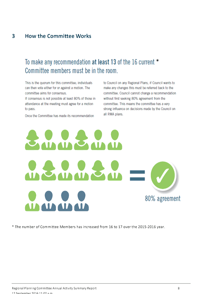
Quorum
and Voting Entitlements Under the Current Terms of Reference
Quorum
(clause (i))
The Quorum for the Regional Planning Committee is 75%
of the members of the Committee
At the present time, the quorum is 14 members.
Voting Entitlement (clause (j))
Best endeavours will be made to achieve decisions on a
consensus basis, or failing consensus, the agreement of 80% of the Committee
members in attendance will be required. Where voting is required all
members of the Committee have full speaking rights and voting entitlements.
Number of Committee members present Number
required for 80% support
19 15
18 15
17 14
16 13
15 12
14 11
HAWKE’S BAY REGIONAL COUNCIL
Regional
Planning Committee
Wednesday 21 September 2016
SUBJECT: Call for any Minor Items Not on the Agenda
Reason for Report
1. Under standing orders, SO 3.7.6:
“Where an item is not on the agenda
for a meeting,
(a) That
item may be discussed at that meeting if:
(i) that
item is a minor matter relating to the general business of the local authority;
and
(ii) the
presiding member explains at the beginning of the meeting, at a time when it is
open to the public, that the item will be discussed at the meeting; but
(b) No
resolution, decision, or recommendation may be made in respect of that item
except to refer that item to a subsequent meeting of the local authority for
further discussion.”
2. The Chairman will request any items committee members wish to be
added for discussion at today’s meeting and these will be duly noted, if
accepted by the Chairman, for discussion as Agenda Item 19.
|
Recommendations
That Regional
Planning Committee accepts the following minor items not on the agenda, for
discussion as item 19:
1.
|
|
Liz Lambert
Chief Executive
|
|
HAWKE’S BAY REGIONAL
COUNCIL
Regional
Planning Committee
Wednesday 21 September 2016
Subject: Follow-up Items from
Previous Regional Planning Committee Meetings
Reason for Report
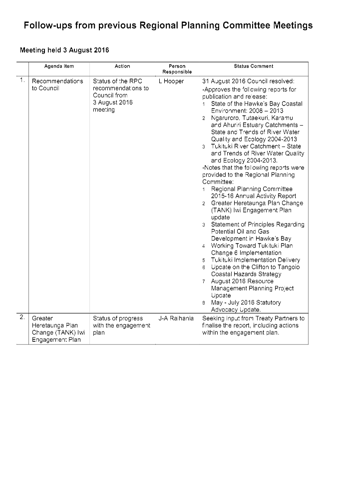
1. On the list attached as Attachment 1 are
items raised at previous Regional Planning Committee meetings that require
actions or follow-ups.
2. All items indicate which RPC agenda item it
relates to, who is responsible for the follow-up, and a brief status comment.
Once the items have been completed and/or reported to the Committee they will
be removed from the list.
Decision Making Process
3. Council is required to make a decision in
accordance with Part 6 Sub-Part 1, of the Local Government Act 2002 (the Act).
Staff have assessed the requirements contained within this section of the Act
in relation to this item and have concluded that as this report is for
information only and no decision is required in terms of the Local Government
Act’s provisions, the decision making procedures set out in the Act do
not apply.
|
Recommendation
That the Regional Planning Committee receives
and takes note of the report “Follow-up Items from Previous Regional
Planning Committee Meetings”.
|
|
Iain Maxwell
Group Manager
Resource Management
|
James Palmer
Group Manager
Strategic Development
|
Attachment/s
|
1
|
Follow-ups
from Prevoius Regional Planning Committee Meetings
|
|
|
|
Follow-ups
from Prevoius Regional Planning Committee Meetings
|
Attachment 1
|
HAWKE’S BAY REGIONAL COUNCIL
Regional
Planning Committee
Wednesday 21 September 2016
Subject: Regional Planning
Committee Activity Annual Report 2015-16 for Adoption
Reason for Report
1. The “Regional Planning Committee – Annual Report for the
1 July 2015 – 30 June 2016 period” provides a summary record of the
work undertaken and decisions made by the Regional Planning Committee over the
past financial year.
2. This version of the report incorporates previous feedback from
Committee members and is ready for publication subject to adoption by the Committee.
An earlier draft version of the annual report, plus the proposal for digital
video format, was presented to the Committee in August.
3. Following the Committee’s meeting in August, a new approach
with this year’s Annual Activity Report has been taken which focussed on
a multimedia production to be made available for public viewing on YouTube,
LinkedIn and Instagram. The finalised production is available to view using the
following link https://www.youtube.com/watch?v=GEP1Q-ICgJg
4. The production will also be available to view at the Regional
Planning Committee meeting on 21 September 2016 for final approval.
Decision Making
Process
5. Council is required to make every decision in accordance with the
requirements of the Local Government Act 2002 (the Act). Staff have
assessed the requirements in relation to this item and have concluded:
5.1. The decision does not significantly alter the service provision or
affect a strategic asset.
5.2. The use of the special consultative procedure is not prescribed by
legislation.
5.3. The decision does not fall within the definition of Council’s
policy on significance.
5.4. Given the nature and significance of the issue to be considered and
decided, and also the persons likely to be affected by, or have an interest in
the decisions made, Council can exercise its discretion and make a decision
without consulting directly with the community or others having an interest in
the decision.
|
Recommendations
That the Regional Planning Committee:
1. receives and notes the “Regional Planning Committee Annual
Report for 1 July 2015 – 30 June 2016 and accompanying multimedia production”
2. adopts the “Regional Planning Committee Annual Report for 1
July 2015 – 30 June 2016” and accompanying multimedia production for public release
and distribution.
|
Authored by:
|
Drew Broadley
Community Engagement and Communications
Manager
|
Esther-Amy
Powell
Planner
|
|
Joyce-Anne
Raihania
Senior Planner Maori Policy Advisor
|
|
Approved by:
|
Gavin Ide
Manager, Strategy and Policy
|
James Palmer
Group Manager
Strategic Development
|
Attachment/s
|
1
|
RPC Annual
Report 2015 - 2016
|
|
|
|
RPC
Annual Report 2015 - 2016
|
Attachment 1
|

|
RPC
Annual Report 2015 - 2016
|
Attachment 1
|
HAWKE’S BAY REGIONAL
COUNCIL
Regional
Planning Committee
Wednesday 21 September 2016
Subject: Mohaka Catchment
Characterisation Report: A Physical Characterisation of the Mohaka Catchment
Reason for Report
1. The report
“A Physical Characterisation of the Mohaka Catchment” has
been prepared to provide an overview of the Regional Council’s scientific
understanding of the natural resources of the Mohaka Catchment and its river
system.
2. The report will
inform the development of a proposed plan change to the Hawke’s Bay
Regional Resource Management Plan (RRMP), addressing the Mohaka Catchment.
3. This report
will be a resource for stakeholders in the Mohaka catchment and other
interested parties who may wish to participate in the Mohaka Catchment Plan
Change process. Hard copies have been provided to members of the Regional
Planning Committee only, and will be available to members of the public upon
request once it has been finalised and approved for publication.
Background
4. This
characterisation report draws on Council’s state of environment
monitoring, an intensive Taharua-Upper Mohaka investigations programme ongoing
since 2006, and recent wider Mohaka investigations. It aims to highlight key
trends and gives a “snapshot” of current state and risks. It should
assist discussion of Mohaka issues, policy needs and provide a baseline for
plan effectiveness monitoring, however it does not claim to be definitive and
knowledge gaps and weaknesses are stated where known. Ongoing science
monitoring and investigations will continue to clarify the picture over time.
5. Nitrogen loss
from land in the Taharua sub-catchment, particularly from 3 large dairy farms,
has degraded the quality of the Taharua and upper Mohaka rivers in recent
years. The Taharua River and the upper Mohaka River have been the focus
of detailed science investigations since 2006, triggered by monthly Taharua
water quality monitoring since 1999.
Executive Summary and Key Findings
6. The Mohaka
Catchment is one of the 7 major water management zones in the Hawke’s Bay
Region. This report is intended to describe the current environmental state and
condition of the catchment through an investigation of different aspects of its
environment. The report is divided into six chapters covering:
6.1. Climate
6.2. Hydrology
6.3. Land
6.4. Groundwater
and geology
6.5. Terrestrial
ecology and
6.6. Wetlands.
Climate
7. The Mohaka
Catchment tends to be wetter and colder than the regional average, and snow on
higher parts of the catchment is not uncommon during winter. Rainfall
over at least the last 30 years does not appear to have exhibited any
particular trends that are strong or consistent across the catchment, except
perhaps that easterly storms have increased in frequency or intensity.
8. Based on warm
air temperatures alone, eastern areas of the catchment could provide the
minimum number of Growing Degree Days (GDDs) required for crops such as grapes
and kiwifruit. Gusty north westerly winds feature in the catchment as they do
elsewhere in the region and assist with drying out the catchment during the
spring and summer period, so that a soil moisture deficit typically exists for
up to 60 days in eastern parts of the catchment where PET exceeds rainfall by
up to 400 mm.
9. Over the next
50 years, climate change is predicted to result in a marginal increase in
annual rainfall over the catchment, based on the median value of an ensemble of
climate models, and a more marked increase in the occurrence of heavy rainfall
events and droughts. Predicted decreases in rain during spring, together with
rising temperatures, increase the need for irrigation by median values of 15 to
25 mm during the growing season.
10. The variations in rainfall
predictions between individual climate models are large and the outcomes less
certain than the predicted rise in air temperature, which is expected to be
1-2°C by 2065. This is expected to result in higher water
temperatures throughout the catchment.
11. The anticipated warming,
and more specifically the associated increase in GDDs, may mean that growing
crops such as grapes and kiwifruit becomes easier or more feasible over a
broader area of the catchment, provided other conditions are suitable.
The Mohaka Catchment is unlikely to change from a temperate to a sub-tropical
climate within the next 50 years.
Hydrology
12. River flow summary
statistics for sites located within the Mohaka River Catchment show the
variations in flow that occur within the Mohaka River and its
tributaries. River flows increase downstream through the Mohaka
River. The Taharua Stream contributes a large proportion of the flow in
the upper Mohaka River during a wide range of flow conditions. Taharua
Stream flows are more stable, with a higher baseflow component in comparison to
flows at most sites on the Mohaka River and its other tributaries. Mean
monthly river flows in the catchment are lowest during February and March.
13. Mean annual flows deviate
from long-term average annual river flows at the Mohaka River at Raupunga site
more prior to 1980, than subsequently. This relates to long-term climate
variability, particularly the positive and negative phases of the Interdecadal
Pacific Oscillation (IPO). Analyses of annual low flows and annual maximum
flows showed no apparent trends.
14. An assessment of consent
information and river flows indicates that the current and historical consented
water abstraction demand in the catchment is low and that the total potential
abstraction effects on river flows are minor, even at low flows.
15. Concurrent gauging data
for the Taharua Stream Catchment show flow in the Taharua Stream increases
downstream through the catchmentas surface water catchment area increases. Flow
data indicates that the interaction between surface water and groundwater is
reasonably consistent throughout the surface water catchment.
Land
16. Mohaka Catchment land is
generally very healthy. Most of the catchment is in native bush, with the next
biggest land use being commercial forestry. There is scope for land use
intensification in the catchment, but large scale intensification is unlikely
due to the high relief and difficulty of access to land in the catchment. It is
possible that commercial forestry could expand within the region. However,
forestry is generally considered one of the less intensive land use systems,
and expansion of forestry should not detrimentally affect the ecological health
of Mohaka Catchment.
17. There are areas of concern
in the upper catchment due to nutrient losses from dairy farms that have
affected water quality and ecosystem health in both the Taharua River and the
upper Mohaka River. This issue is currently being addressed with the help of
the farmers concerned and other stake holders.
Geology and Groundwater
18. The geology of the Mohaka
catchment consists of mostly soft sedimentary rock in the mid to lower
catchment and hard greywacke basement rock, volcanic ignimbrite rock and
unconsolidated pumice in the upper catchment. The volcanic ignimbrite rock and
unconsolidated pumice are sourced from the Taupo Volcanic Zone.
19. The known groundwater
resource in the Mohaka Catchment is mostly confined to the volcanic ignimbrite
in the upper catchment of the Taharua valley. The remainder of the Mohaka
Catchment is dominated by greywacke rock, which is unlikely to yield a
productive groundwater resource. In the lower Mohaka catchment several bores
have been drilled into the sedimentary mudstone, sandstone and limestone rock
formations, but there is little information known about the groundwater
resource in these rock formations.
20. The focus of groundwater
investigation has been on the Taharua sub-catchment to support water quality
investigations. From available geological bore logs, 3 water bearing formations
are found in this sub-catchment:
20.1. Gravels eroded from the
nearby greywacke ranges (30-100 m deep)
20.2. Ignimbrite rock aquifer
sourced from the eruptions in the northern Taupo Volcanic Zone (also 30-100 m
deep)
20.3. A shallow Taupo Pumice
aquifer up to 20 m thick.
21. Chemical groundwater
quality assessment of shallow investigations bores and private water supply
bores in the Taharua Catchment indicates groundwater in both the shallow Taupo
pumice aquifer and the deeper Ignimbrite/gravel aquifer ignimbrite can be used
for drinking without treatment.
22. The Taupo pumice aquifer
is impacted by nitrate-N in the upper Taharua sub catchment and at some sites
have high nitrate- N which is half the drinking water Maximum Allowable Value.
The most likely sources of the nitrate-N are from intensive dairying in this
area. Some sites in the shallow pumice aquifer are also elevated in iron and
manganese and do not meet the guideline values. Most sites also comply
with the ANZECC irrigation guidelines except for low hardness, which may cause
corrosion of metal pipework.
23. Trend analyses of data
from shallow bores and Taharua spring indicates that nitrate-N in groundwater
has decreased in 2 bores and increased in 1 monitoring bore and phosphorus
levels have increased in 1 monitoring bore and the Taharua spring. The sites
with both increasing and decreasing trends are located in the vicinity of dairy
farms.
24. All 3 monitoring sites are
located on a dairy farm that has undergone a significant decrease in stocking
rate and associated reduction in nitrogen inputs after a change in farm
ownership in 2009[1].
Further monitoring is needed to confirm the validity of these trends.
25. The groundwater from the
deep ignimbrite/gravel aquifer has a mean residence time >90 years,
suggesting that the groundwater in the deeper ignimbrite aquifer is very old
and has a long residence time indicating that the active groundwater flows does
not reach this depth. Groundwater in the shallower Taupo Pumice aquifer
groundwater has a mean residence time of less than five years suggests that
recharge source is derived from local rainfall recharge sources.
26. The age of Taharua River
water increases down the catchment from 1 year at the spring to 8 years at the
confluence with the Mohaka River. This steady increase in water age downstream
in the Taharua River indicates an increasing contribution of water from longer
flow paths from deeper parts of the groundwater system with increasing distance
from the head of the recharge area.
27. The presence of
significant amounts of old water in the stream is probably related to larger
water storage capacity of the volcanic pumice aquifer material. Good hydraulic
conductivity of the volcanic material in the Taupo Pumice aquifer is suggested
by streams sourced from the greywacke rock hill country running dry at the
interception with the volcanic pumice which infills the valley forming the
current topographic surface (Morgenstern, 2014).
Biodiversity
28. The pattern of indigenous
vegetation habitat loss in the Mohaka Catchment is similar to the regional and
national situation, where these habitats have been lost from lowlands and
remained on mountain ranges. However, the catchment is characterised by a
higher proportion of indigenous forest and scrub than the region.
29. Most of the catchment is
part of - or adjacent to - key public and privately-owned conservation areas,
where conservation efforts have been made. The catchment is also home to
2 of the few remnants of frost flats left in New Zealand. Although there
is no quantitative framework, the Mohaka Catchment has high values of
terrestrial biodiversity.
Wetlands
30. The catchment has lost
most of its wetlands. The condition of remaining wetlands requires targeted
investigation and investigation of why it has been lost. There is very
low representation of wetlands in existing protected areas. This, and the
degree of loss, leaves wetlands as one of the most acutely threatened
ecosystems in the Mohaka Catchment.
Decision Making
Process
31. Council is required to
make every decision in accordance with Part 6 Sub-Part 1, of the Local
Government Act 2002 (the Act). Staff have assessed the requirements in
relation to this item and have concluded that, as this report is for
information only and no decision is to be made, the decision making provisions
of the Local Government Act 2002 do not apply.
|
Recommendations
That the Regional Planning Committee receives and takes note of
the “Mohaka Catchment Characterisation Report: A Physical
Characterisation of the Mohaka Catchment”.
|
Authored by:
|
Dr Barry
Lynch
Principal Scientist /
Team Leader - Land
|
Dr Kathleen
Kozyniak
Principal Scientist Climate & Air
|
|
Keiko Hashiba
Terrestrial Ecologist
|
Dougall
Gordon
Principal Scientist, Groundwater
|
|
Rob Waldron
Senior Resource Analyst
|
|
Approved by:
|
Dr Stephen
Swabey
Manager, Science
|
Iain Maxwell
Group Manager
Resource Management
|
Attachment/s
There are no
attachments for this report.
HAWKE’S BAY REGIONAL
COUNCIL
Regional
Planning Committee
Wednesday 21 September 2016
Subject: Mohaka Plan Change Work
Programme
Reason for Report
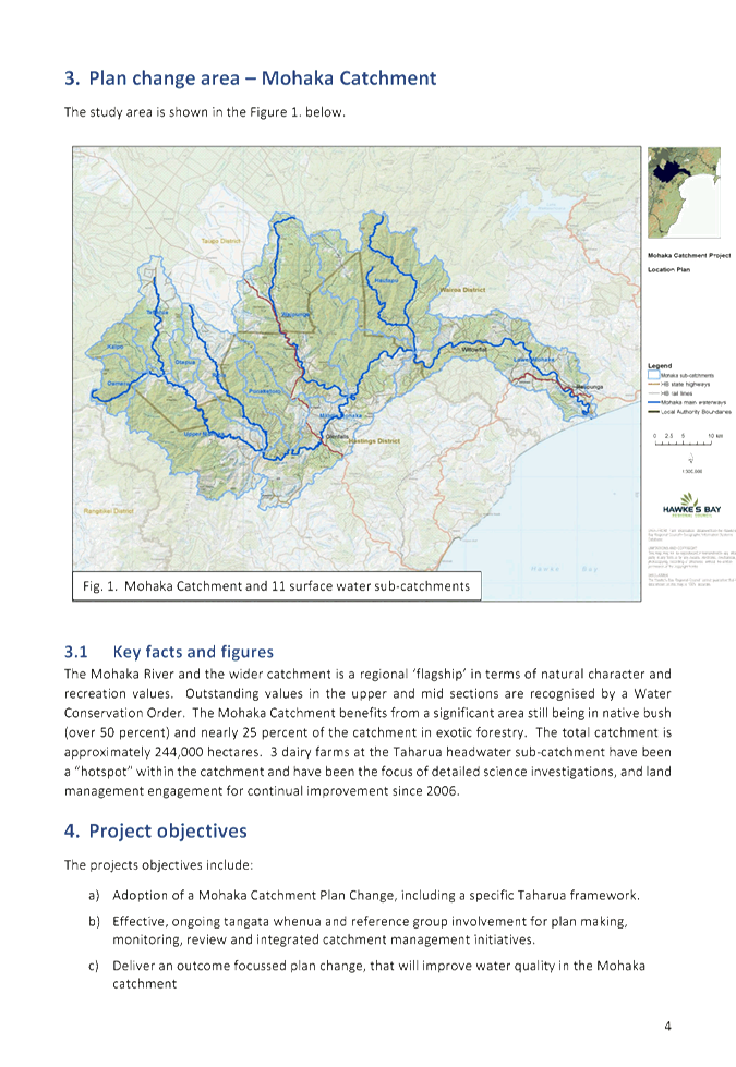
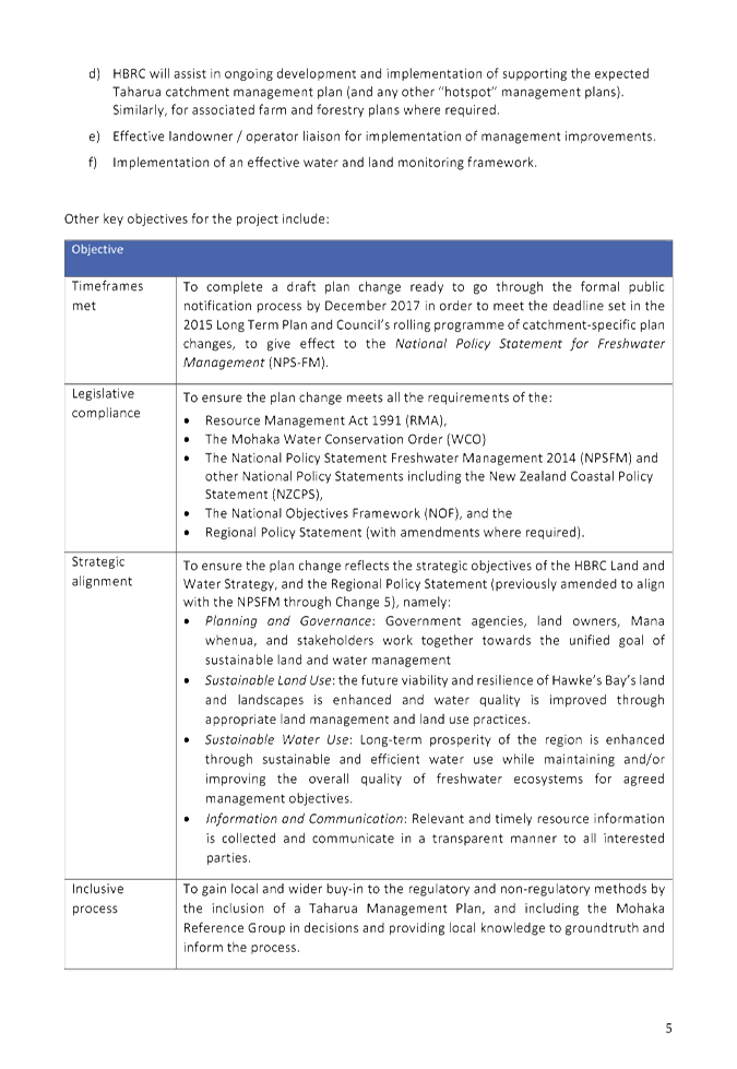
1. The purpose of
this report is to advise the Regional Planning Committee (RPC) of the work
programme for the Mohaka Plan Change project to give effect to the National
Policy Statement on Freshwater Management 2014 in the Mohaka catchment. This
includes the attached project plan, seeking to deliver the draft plan change by
December 2017. This coincides with the completion of the Mohaka Catchment
Environmental Characterisation Report, (refer separate agenda item for
RPC’s 21 September meeting).
2. The
Environmental Characterisation Report provides the additional prerequisite
science and information to re-engage with the previously convened Mohaka
Stakeholder Reference Group to progress the plan change. This complements an
earlier notable report presented to the RPC in 2015 - the Mohaka River Catchment
– State and Trends of River Water Quality and Ecology October 2015.
3. Whilst
timeframes and resourcing will remain challenging, staff are committed to
completing the draft plan change by December 2017 in line with Long Term Plan
(LTP) timeframes.
Financial and Resource Implications
4. Delivery of the
draft Plan Change is provided for and budgeted in the LTP and Annual Plan.
Costs associated with forthcoming engagement and drafting are funded from
budgets for Project 192 Strategy and Planning. The most significant costs
associated with engagement were invested over the previous five year
collaborative Taharua Stakeholder Group process.
Decision Making
Process
5. Council is required to make every decision in accordance with the
requirements of the Local Government Act 2002 (the Act). Staff have
assessed the requirements in relation to this item and have concluded:
5.1. The decision does not significantly alter the service provision or
affect a strategic asset.
5.2. The use of the special consultative procedure is not prescribed by
legislation.
5.3. The decision does not fall within the definition of Council’s
policy on significance.
5.4. The persons
affected by this decision are all people with an interest in the region’s
management of natural and physical resources under the RMA.
5.5. Options that have been considered include the requirements
placed on engagement with the Mohaka Reference Group and Mohaka iwi/hapu to
allow a sufficiently robust plan change to be prepared within timeframes. It is
considered that continued documentation of the level of engagement provides
transparency and helps manage expectations for all interested
parties/stakeholders as drafting of the plan change moves to completion.
No option was evaluated associated with extending the December 2017 timeframe.
5.6. The decision is not inconsistent with an existing policy or plan.
5.7. Given the nature and significance of the issue to be considered and
decided, and also the persons likely to be affected by, or have an interest in
the decisions made, Council can exercise its discretion and make a decision
without consulting directly with the community or others having an
interest in the decision.
|
Recommendations
1. That the Regional Planning Committee receives the “Mohaka
Plan Change Work Programme” report.
2. The Regional Planning Committee recommends that Council:
2.1. Agrees that the decisions to be made are not significant under the
criteria contained in Council’s adopted Significance and Engagement
Policy, and that Council can exercise its discretion under Sections 79(1)(a)
and 82(3) of the Local Government Act 2002 and make decisions on this issue
without conferring directly with the community and persons likely to be
affected by or to have an interest in the decision.
2.2. Approves the Mohaka Project Plan, subject to any adjustments
required and agreed by the Regional Planning Committee, to guide delivery of
the Draft Plan Change for the Mohaka catchment.
|
Authored by:
|
Desiree Cull
Programme Leader
|
Shane Lambert
Senior Planner
|
Approved by:
|
James Palmer
Group Manager
Strategic Development
|
|
Attachment/s
|
1
|
Final Mohaka
Project Plan
|
|
|
|
Final
Mohaka Project Plan
|
Attachment 1
|
HAWKE’S BAY REGIONAL COUNCIL
Regional
Planning Committee
Wednesday 21 September 2016
Subject: Weekly Meter Reading
for Water Takes from November 2016
Reason for Report
1. This is an
update on the implementation of the Resource Management (Measurement and
Reporting of Water Takes) Regulations 2010 (MRWT Regulations). There is a final
phase in for metering smaller takes that is required in November. Council has
been advising affected resource consent holders of this over the past year.
Discretion may be applied as to whether daily or weekly recording is required.
2. A Council
decision is required to determine whether takes of 5 L/s to 9.99 L/s should be
able to report on a weekly basis where they are in a sensitive groundwater
area.
Background
3. The MRWT
Regulations phased in the requirements for water meters, with rates of take
> 20 L/s required to have water meters by November 2012, and takes
with a rate between 10 L/s and 19.99 L/s requiring a meter by November 2014.
4. The MRWT
regulations require consented water takes with an authorised rate of take of
between 5 L/s and 9.99 L/s to be metered prior to 10 November 2016.
5. There is no
discretion under the MRWT Regulations as to whether takes greater than
5 L/s are metered or not.
6. The MRWT
Regulations require daily meter readings unless an approval to allow for weekly
readings is given by the Council under Regulation 9.
7. Council has
delegated this discretion to Council Officers.
8. Council’s
approach (Council Decision 24 November 2010) has been to only give approval for
weekly readings to be taken where the take is not a surface water take or stream
depleting groundwater take, and where the groundwater take is not located
within a ‘sensitive groundwater area’.
9. ‘Sensitive
groundwater areas’ have been defined internally by staff. They
include areas identified by the RRMP Schedule VI as being ‘Water
Short’ plus other areas where there are known issues of well interference
or stream depletion.
10. There are 220 groundwater
consents with a rate of take of 5 L/s to 9.99 L/s; 40 are already required to
be metered (18%), and the remaining 180 consents will be required to install
meters prior to 10 November 2016.
11. Of the 180 groundwater
takes that will need to install meters under the MRWT Regulations this year,
about half (90) of them are located within a ‘sensitive groundwater
area’ (SGA), and under the Council’s past approach would have been
required to take daily readings from 10 November 2016. In practice, this
requirement often results in the need for people to install telemetry systems.
12. Of the 86 groundwater
consents within the SGA, most are orchards (54%), cropping blocks (16%) and
vineyards (11%). The average size of the blocks is approximately
7 ha.
13. Should these 86 takes be
required to take daily readings, or is approval for weekly readings
appropriate?
14. In considering this
question the following factors have been taken into account:
14.1. A requirement for daily
water use readings may practically result in the need for people to install
telemetry. There is a significant cost associated with installation and
operation of a telemetry system.
14.2. The blocks are
relatively small, and are less likely to be run by larger scale operators with
existing telemetry systems.
14.3. The TANK plan change is
likely to contain policy provisions which set out metering and telemetry requirements.
The s32 report for the TANK plan change will consider the costs and benefits of
any approach that is put forward.
14.4. It is unlikely that
daily water use data for these relatively small takes will be used to support
groundwater science (e.g. the groundwater model). It is more likely that
aggregated water use data at a monthly or annual time period will be
used. This data would still be available from these takes even if they
read their meters at a weekly frequency.
15. The identified options are
to:
15.1. Allow an interim
exemption to all groundwater takes with rates of take between 5 L/s to
9.99 L/s until 10 November 2019, or some other defined date.
15.2. Continue with the past
approach and not provide any exemptions to those takes within sensitive
groundwater areas.
16. While option 2 has the
benefit of being consistent with the past approach, it will result in more
onerous requirements for small scale consent holders. It is recommended
that option 1 be taken. TANK may determine that daily meter readings
and/or telemetry is warranted across the plains, in which case the approval to
take weekly readings under Regulation 9 will not be extended. Taking this
option will ensure that the metering requirement is consistent with the provisions
of the TANK plan change, which will be developed with full regard to potential
costs and benefits, and in light of any input from key stakeholders.
17. It is noted that the
approvals for weekly readings may not be given or may be subsequently revoked
in any case where there is doubt over the actual pump rate and volume taken,
where there is lack of compliance with the return of water meter data, where
transfer and sharing of water permits occurs, or where portable meter systems
are being used on portable pumps across multiple properties.
Financial and Resource Implications
18. There are no financial
implications to the Council. The cost on consent holders of more frequent
reading of meters and potentially telemetry will not be imposed on small scale
groundwater takes where more frequent reporting is not required.
Decision Making
Process
19. Council
is required to make every decision in accordance with the requirements of the
Local Government Act 2002 (the Act). Staff have assessed the requirements
in relation to this item and have concluded:
19.1. The decision
does not significantly alter the service provision or affect a strategic asset.
19.2. The use of
the special consultative procedure is not prescribed by legislation.
19.3. The decision
does not fall within the definition of Council’s policy on significance.
19.4. The persons affected by this
decision are existing and future consent holders with water take permits for
small rates and quantities of water.
19.5. Options that
have been considered include require daily reporting or allow weekly
reporting where appropriate.
19.6. The decision
is not inconsistent with an existing policy or plan.
19.7. Given
the nature and significance of the issue to be considered and decided, and also
the persons likely to be affected by, or have an interest in the decisions
made, Council can exercise its discretion and make a decision without
consulting directly with the community or others having an interest in
the decision.
|
Recommendations
1. That the Regional Planning Committee receives and notes the
“Weekly Meter Reading for Water Takes from November 2016” report.
2. The Regional Planning Committee recommends that Council:
2.1. Agrees that the decisions to be made are not significant under the
criteria contained in Council’s adopted Significance and Engagement
Policy, and that Council can exercise its discretion and make decisions on
this issue without conferring directly with the community and persons likely
to be affected by or to have an interest in the decision.
2.2. Agrees to Council staff exercising discretion to allow consent
holders of groundwater water takes that are greater than 5 L/s and less than
9.99 L/s to measure and report their usage weekly where this is appropriate.
|
Authored by:
|
Paul Barrett
Senior Consents Planner
|
|
Approved by:
|
Malcolm
Miller
Manager Consents
|
Iain Maxwell
Group Manager
Resource Management
|
Attachment/s
There are no
attachments for this report.
HAWKE’S BAY REGIONAL COUNCIL
Regional
Planning Committee
Wednesday 21 September 2016
Subject: Northern Hawkes Bay
Land Management Issues
Reason for Report
1. This
paper updates the Regional Planning Committee on a report by Dr Sean Weaver
commissioned by the Council and the Ministry for Primary Industries which
explores options for addressing both acute and chronic effects of land use in
Northern Hawke’s Bay. Further advice on a package of actions proposed by
the Ministry and council staff will be brought back to the Committee once
funding decisions have been made by ministers.
Background
2. Clearance
of indigenous forest for pastoral lands in Northern Hawke’s Bay has long
been a source of soil erosion with associated land use productivity, flood
management, water quality and coastal environmental impacts. The topography and
geomorphology in Northern Hawke’s Bay induces erosion of an exceptionally
high intensity by both national and international standards. Since the 1941
Soil Conservation and River Controls Act, central government through the NZ
Forest Service, catchment boards and more latterly the Hawke’s Bay
Regional Council, have sought to address this erosion through the establishment
of erosion control planting and plantation forestry on particularly erosion
prone land. Tax incentives during the 1990s spurred further forest establishment.
3. Many
of these plantation forests are now being harvested with considerably more
harvest activity yet to come. These harvests are putting the spotlight on the
impacts of harvest practices – particularly sediment and forest slash -
on waterways, coastal environments and infrastructure, and on the
Council’s ability to regulate these activities to the satisfaction of the
community. Harvests are also posing questions for industry and for the Council
on where replanting should occur or where permanent retirement from forestry
may be required to meet water quality and soil conservation objectives over the
longer-term. The predicted increased frequency of extreme climatic events may
well accentuate or accelerate some of these challenges.
4. Freshwater
reform will pose particular challenges for the Council and the local community
in Northern Hawke’s Bay given that historic land use decisions are having
a significant impact on water quality and that land use and land management
practice will have to undergo major changes if high levels of ecological health
are to be achieved. In some cases forestry will be a necessary alternative to
current pastoral land-use and will continue to be an important component in the
district’s economy.
5. Issues
arising from harvest practices are exacerbating community concerns toward
forestry, which risk undermining the social license for the industry to operate
and the ability for the Council to promote forestry as part of the tool-box of
solutions for erosion prone land. In addition to this community sentiment there
are also other social and economic barriers to land use change that need to be
carefully considered.
Comment
6. Following
the Council Chairman’s recent meeting with Ministers Guy and Tolley
regarding the effects of land management activities on waterways in the Wairoa
District, Dr Sean Weaver was commissioned by the Council and Ministry for
Primary Industries to provide options for enhancing existing initiatives to
improve land and water outcomes.
7. The
attached Weaver Report has highlighted that the existing tool-box of
interventions, from which the Council and central government can currently draw
upon, are insufficient to support the level of land use management and change
for both forestry and pastoral farming necessary to deliver high levels of
water quality. Further tools, including land and water science, decision
support advice, and financial incentives for land management and land use
change will be required. This will require resources that are currently not
available or provided for in the Council’s Long Term Plan, and mechanisms
available from central government fall short of what is required as well.
8. A
policy decision taken by central government in the early 1990s saw the East
Coast Forestry Project, which provided financial assistance for converting
erosion vulnerable land to forestry following Cyclone Bola, confined to the
Gisborne District. This was an arbitrary decision that did not account for the
fact that land use issues in Northern Hawke’s Bay are the same as the
Gisborne District. In light of persistent underspends in the East Coast
Forestry Project the Ministry for Primary Industries, which administers the
Project, is currently providing advice to ministers on whether changes to the
scheme are warranted to address land use challenges in Northern Hawke’s
Bay. These changes may make funding available for a programme of work to
address land management issues in this part of the region, including new
science, decision support and incentives, and potentially piloting initiatives
for scaling up regionally and potentially nationally.
9. At
the time of writing we are awaiting a decision from ministers on resourcing
available to develop a proposed programme of work. This programme is still very
much under development, drawing from the Weaver Report. Details of the
proposed programme of work will come to the Regional Planning Committee once
MPI’s resources have been secured and local engagement has been
undertaken on design. This programme could help deliver the Regional Economic
Development Strategy actions that relate to land use productivity, freshwater
reform and climate change resilience.
Financial and Resource Implications
10. The Council
already has two land management advisors based in Northern Hawkes Bay who work
with land owners to address land management practices. Should funding be made
available then the Council will look to deploy these staff, as well as science
staff, in a complementary manner to support a programme of work to the extent
that is possible. However, capacity to redeploy in this manner is limited given
other pressures and longer-term the Council will need to consider the full
resource implications of implementing freshwater reform and NPSFM
implementation in North Hawkes Bay. It is proposed that advice on these
implications will be provided as part of the next iteration of the Long Term
Plan in the 2017/18 year.
Decision Making
Process
11. Council is
required to make every decision in accordance with Part 6 Sub-Part 1, of the
Local Government Act 2002 (the Act). Staff have assessed the requirements
in relation to this item and have concluded that, as this report is for
information only and no decision is to be made, the decision making provisions
of the Local Government Act 2002 do not apply:
|
Recommendations
1. That the Regional Planning Committee receives and notes the “Northern
Hawkes Bay Land Management Issues” report.
1.1. Notes the report from Dr Sean Weaver on land use issues in
Northern Hawkes Bay.
|
Authored by:
|
James Palmer
Group Manager
Strategic Development
|
|
Approved by:
|
Liz Lambert
Chief Executive
|
|
Attachment/s
|
1
|
Northern
Hawke's Bay Sustainable Land Management Strategy Options Paper
|
|
Under
Separate Cover
|
HAWKE’S BAY REGIONAL
COUNCIL
Regional
Planning Committee
Wednesday 21 September 2016
Subject: 2009-14 Assessment of
State and Trends in Groundwater Quality of Hawke's Bay Region
Reason for Report
1. Under Section
35(2)(a) of the Resource Management Act (RMA) local authorities are required to
monitor the state of the whole or any part of the environment to the extent
that is appropriate to enable the local authority to effectively carry out its
functions under the RMA. State of the Environment (SoE) monitoring and
reporting is a key statutory function of the Regional Council.
2. Hawke’s
Bay Regional Council (HBRC) undertakes routine groundwater quality data
collection at monitoring sites in the main productive aquifers in the region.
Groundwater quality monitoring is used to assist with policy development and
policy effectiveness and resource management consent decision making.
3. This technical
report is provided as underlying information that informs the five yearly State
of the Environment: Trends report. Hard copies have been provided to RPC members
only, and will be made available to the public upon request.
Background
4. Groundwater is
used and relied upon as a source of drinking water, industrial, irrigation and
stock water supplies across the Hawke’s Bay region. Groundwater discharge
to surface water plays an important role in the maintenance of surface stream
flow, so groundwater quality also has a consequential impact on surface water
quality. Intensification of land use poses a potential threat to the
sustainability of the groundwater resource.
5. This report
summarises the state and trends in groundwater quality from 40 monitoring sites
across the region, including the Heretaunga and Ruataniwha Plains, Wairoa,
Poukawa and Mahia aquifer systems. State is assessed over the 5 years of data
collected between January 2009 and 31st December 2013 and trends are
assessed using the long term data set from 1 January 1999 to 31st
December 2013.
6. Key water
quality parameters are used to assess the state and trends in groundwater
quality and are assessed relative to New Zealand Drinking Water Standards
(DWSNZ) and Australian and New Zealand (ANZECC) irrigation guidelines, as
outlined in the HBRC’s Regional Resource Management Plan (RRMP).
7. There are both
maximum acceptable values (MAV) related to human health and also guideline
values in the DWSNZ. The ANZECC irrigation guidelines trigger values key
parameters in the guidelines. The parameters used in state and trend
assessments include; the microbiological indicator E. coli, and chemical
parameters including ammoniacal nitrogen, nitrite- nitrogen, nitrate-nitrogen,
manganese, iron, sulphate, sodium, chloride total hardness, total dissolved
solids, and pH.
Key Findings
8. Hawke’s
Bay aquifer systems are generally suitable for drinking water supply, except
where they are affected by naturally occurring iron, manganese and hardness,
which are water quality parameters that affect aesthetics. Manganese also has
health MAV and 78% of sites in the region comply with this limit. Iron,
manganese and hardness are particularly elevated in the Poukawa (limestone),
Wairoa and Mahia aquifer systems.
9. Nitrate levels
are typically low, and better than drinking water standards. In the last
5-years 88% of sites monitored were between 90% and 100% compliant with the microbiological
indicator E. coli.
10. Elevated E. coli is
sometimes found in monitoring bores less than 10 m deep in unconfined aquifers.
Shallow unconfined aquifers are susceptible to contamination by pathogens
because they have limited ability to filter out contamination. Bores less than
10 m deep are considered unsecure, according to the DWSNZ, and use of water for
drinking would require treatment. The remaining sites in the region are over 10
m deep and were generally compliant with the DWSNZ.
11. 17.5% of Hawke’s Bay
sites had increasing (worsening) trend in nitrate-nitrogen (nitrate-N). The
largest proportion of increasing trends occurs in the Ruataniwha aquifer
system, followed by the Mahia aquifer system and the Heretaunga aquifer system.
No trends in nitrate-N were found in the Poukawa and Wairoa aquifer systems.
The Ruataniwha and Heretaunga plains have more intensive horticulture and
agriculture, while Mahia has lower intensity pastoral farming. However, the
Mahia aquifer is likely to be more susceptible to contamination since the
aquifer is unconfined sand and alluvium.
12. The figure of 17.5%
worsening sites in Hawke’s Bay compares with a national trend of 20%
increasing nitrate-N for sites across New Zealand (Daughney et.al 2008).
13. Most sites in the region
comply with the irrigation guidelines for quality contained within the
Australian and New Zealand Guidelines for Fresh and Marine Water, except for
iron and manganese, which is elevated in most aquifers in the region. No sites
in the Poukawa and Wairoa aquifers complied with iron, manganese or hardness
guidelines. 87% of sites in the Heretaunga Plains aquifer comply with manganese
and iron guidelines. Sites that did not comply were generally in deeper parts
of the aquifer system. In the Ruataniwha basin 50% of sites had hardness levels
that were better than the hardness corrosion limit.
14. 80% of sites in the region
have a decreasing trend in manganese and 40% of sites have decreases in iron.
These 2 parameters are naturally occurring and are enriched in deeper parts of
aquifer systems because they reside there for long periods of time. It is
difficult to identify the factors controlling the worsening trend. It could be
related to changes in recharge that may be affecting water-rock interactions.
15. 72.5% of sites had no
trend in phosphorus. However, 27.5% of sites had an increase in phosphorus. The
highest proportion of sites with increases in phosphorus were located in the
Mahia and Heretaunga aquifer systems, followed by the Ruataniwha aquifer
system. These increasing trends may be related to land-use activities over the
aquifer systems.
16. The Hawke’s Bay
Regional Council is one of 14 regions that participates in the national
pesticide monitoring programme. No pesticides were detected in groundwater for
either the 2010 and 2014 regional pesticide survey.
Decision Making Process
17. Council is required to
make every decision in accordance with Part 6 Sub-Part 1, of the Local
Government Act 2002 (the Act). Staff have assessed the requirements in
relation to this item and have concluded that, as this report is for
information only and no decision is to be made, the decision making provisions
of the Local Government Act 2002 do not apply.
|
Recommendations
That the Regional Planning Committee receives and takes note of
the “2009-14 Assessment of State and Trends
in Groundwater Quality of Hawke's Bay Region” report.
|
Authored by:
|
Dougall
Gordon
Principal Scientist, Groundwater
|
|
Approved by:
|
Dr Stephen
Swabey
Manager, Science
|
Iain Maxwell
Group Manager
Resource Management
|
Attachment/s
There are no
attachments for this report.
HAWKE’S BAY REGIONAL
COUNCIL
Regional
Planning Committee
Wednesday 21 September 2016
Subject: Spatial Oxygen-Flow
Models for Streams of the Heretaunga Plains
Reason for Report
1. This report investigates the relationship between stream flow and
dissolved oxygen available for fish in Heretaunga Plains streams. This
information is intended to inform limit selection (e.g. minimum flow sites) by
the TANK (Tutaekuri, Ahuriri, Ngaruroro, Karamu) Stakeholder Group, which was
assembled for the Greater Heretaunga Plan Change.
Background
2. Fish and other stream life depends on having sufficient freshwater
to survive. Reduced flow can reduce oxygen in low-gradient streams, like the
Karamu, that support high abundances of aquatic plants.
3. Hawke’s Bay Regional Council manages allocation of water, to
safeguard the life-supporting capacity of our streams. For example, there is a
minimum flow of 300 L/s set for the Raupare Stream, which affords a level of
protection to whitebait and eels inhabiting the stream. When stream flow drops
below 300 L/s, some irrigators are required to stop water use until higher
flows return. That minimum flow will be revisited during the proposed Greater
Heretaunga Plan Change.
4. A previous report provided recommendations on minimum flows for the
Raupare Stream, plus 2 other sites. This most recent report expands on that, by
identifying streams on the Heretaunga Plains that are more susceptible to low
oxygen. This is intended to inform decisions on where minimum flow sites might
be located. This report will not evaluate the magnitude of minimum flows at
particular sites.
5. Along with identifying streams that are more susceptible to low
oxygen, the role of aquatic plants was also assessed. The investigation also
evaluated the positive role that riparian shading has on flow requirements for
oxygen supply.
6. The process of selecting minimum flows will probably require the
identification of oxygen limits for streams. This report presents new
information that has implications for those oxygen limits, including the
physical constraints on oxygen in low-gradient streams and the measured
response of fish to oxygen. Oxygen limits are discussed in this report to
better inform that limit-setting process.
Discussion
7. Observations and modelling both indicate that oxygen is a critical
issue to consider when managing flows of these streams to safeguard their
life-supporting capacity.
8. The modeling indicates that, for the same flow, less oxygen is
produced in streams with flatter gradients and larger channels.
9. A prioritised list of potential monitoring sites is presented for
each sub-catchment on the Heretaunga Plains, which is intended to inform
decisions by stakeholders or regulators. Priority was given to sites that
better represent the reaches at risk of low oxygen and with the highest water
demand. The flexibility of a prioritised list allows sites to be added in
future, as water demand increases. That flexibility also allows stakeholders to
choose lower priority sites based on other criteria (e.g. higher instream
values).
10. Riparian
shading that reduces solar access (incident sunlight on the stream) to less
than 30% of the November-April maximum is expected to reduce aquatic plant
growth and improve oxygen supply to fish.
11. Both flow
management and riparian management can be applied to ensure oxygen supply from
the water exceeds oxygen demand for fish survival.
12. Alternative
oxygen limits are recommended for low-gradient streams, including a daily
minimum of 40% oxygen saturation. The National Policy Statement for Freshwater
Management includes a ‘National Bottom Line’ of 50% oxygen. That
bottom line is not a statutory limit for minimum flows because it only applies
“below point discharges”.
13. The
external peer-reviewer of the technical report did not agree with the 40% limit
that was proposed. Rather than seek scientific consensus, both limits will be
presented to stakeholders as alternative options.
Decision Making
Process
14. Council is required to
make every decision in accordance with Part 6 Sub-Part 1, of the Local
Government Act 2002 (the Act). Staff have assessed the requirements in
relation to this item and have concluded that, as this report is for
information only and no decision is to be made, the decision making provisions
of the Local Government Act 2002 do not apply.
|
Recommendations
That the Regional Planning Committee
receives and takes note of the “Spatial Oxygen-Flow Models for
Streams of the Heretaunga Plains” report.
|
Authored by:
|
Thomas
Wilding
Senior Scientist
|
|
Approved by:
|
Dr Jeff Smith
Team Leader/Principal Scientist
Hydrology/Hydrogeology
|
Dr Stephen
Swabey
Manager, Science
|
|
Iain Maxwell
Group Manager
Resource Management
|
|
Attachment/s
There are no
attachments for this report.
HAWKE’S BAY REGIONAL
COUNCIL
Regional
Planning Committee
Wednesday 21 September 2016
Subject: Hawke’s Bay
Regional Council Land Science Strategy 2016: A New View of the Land
Reason for Report
1. This report outlines a new Land Science Strategy for Hawke’s
Bay Regional Council (HBRC). The new strategy will guide the Council’s
Land Science programme of work through the short to medium term period ahead.
Background
2. In recent years land science has come much more to the fore
nationally with an increasing understanding of how land issues are affecting
water quality. Central and regional government are placing more emphasis on
policies, legislation and directives around the terrestrial environment than
ever before creating a more complex environment for Council land science to
operate in.
3. The new Land Science Strategy has looked at all of the current
national and regional land science initiatives and linked them with
HBRC’s work programme. By doing this we can be confident that
HBRC’s Land Science programme is not only meeting regional needs but also
taking into account national level strategies keeping HBRC’s Land Science
programme relevant and robust heading in to the future.
Summary
4. The management
of risks, realising opportunities such as increasing land productivity, and
meeting reporting obligations within a regional council require timely and
effective science input. The purpose of this project is to provide the
Hawke’s Bay Regional Council (HBRC) with strategic guidance for Land
Science, providing clarity on regional land priorities as well as the research
impacts and initiatives needed to deliver on these priorities.
5. The strategic
guidance has been designed to ensure that the Land Science Programme:
5.1. has
access to the right science to support better land management decision-making
5.2. is
equipped with the right science-based tools to monitor progress towards
outcomes
5.3. makes
the best investment in research activities to support the needs of the region
and
5.4. leverages
and contributes to wider system efforts, thereby increasing cost-effectiveness.
Approach
6. The guidance is
structured to provide clarity on the:
6.1. role of Land
Science within HBRC (the who)
6.2. outcomes the
Land Science Programme should enable (the why)
6.3. research
impacts to be delivered (the what)
6.4. way the Land
Science Programme should work (priorities, partnerships and connections –
the how).
Results
7. A Strategic
Roadmap provides clarity on the role, outcomes, research impacts, and way in
which Land Science should be provided. The Roadmap also offers a number of
pathways for Land Science to ensure consistency, particularly for the
implementation of national policies (e.g. freshwater reforms) and to fulfil
national obligations (e.g. under the Environmental Reporting Act) as well as
leverage initiatives across the regions and nationally.
8. The rudimentary
review, analysis, and ranking of research impacts through an outcome-based
framework will ensure Land Science has a clear rationale for investment
decision-making, makes intentional choices on priorities, and remains relevant
to today's operating environment.
Recommendations
9. Five
recommendations are provided to ensure the intent of the project is realised
and the Roadmap becomes a resource of enduring relevance and value to the Land
Science programme and HBRC more generally. They are:
9.1. The
prioritised research impacts and Roadmap are presented widely within the
Council and shared with key external collaborators
9.2. Greater
effort is made to jointly explore science needs and scope in areas of mutual
interest, in particular with Land Management and Water Science
9.3. Immediate
action is taken to optimise the opportunities in the external environment
9.4. The Land
Science team continues to contribute and participate in relevant activities
outlined in the Roadmap to maximise the opportunities for leverage and
alignment
9.5. Strategic
scans are periodically undertaken to ensure the Roadmap remains relevant to
needs and changes in the wider system.
Decision
Making Process
10. Council is required to
make every decision in accordance with Part 6 Sub-Part 1, of the Local
Government Act 2002 (the Act). Staff have assessed the requirements in
relation to this item and have concluded that, as this report is for
information only and no decision is to be made, the decision making provisions
of the Local Government Act 2002 do not apply.
|
Recommendation
That the Regional Planning Committee
receives and notes the “Hawke’s Bay Regional Council Land
Science Strategy 2016: A New View of the Land” report.
|
Authored by:
|
Dr Barry
Lynch
Principal Scientist / Team Leader - Land
|
|
Approved by:
|
Iain Maxwell
Group Manager
Resource Management
|
|
Attachment/s
|
1
|
HBRC Land
Science Strategy 2016
|
|
Under
Separate Cover
|
HAWKE’S BAY REGIONAL
COUNCIL
Regional
Planning Committee
Wednesday 21 September 2016
Subject: National Policy
Statment for Freshwater Managment - Progressive Implementation Programme Annual
Report 2015-16
Reason for Report
1. The purpose of
this paper is to report on key implementation milestones and activities
undertaken by HBRC during the 2014-15 financial year as part of implementing
the 2014 National Policy Statement for Freshwater Management (NPSFM) as set out
in the Progressive Implementation Programme.
2. The content of
this report will form the basis of the HBRC Annual Report 2015-2016.
Background
3. The first NPSFM
came into effect on 1 July 2011, and was then amended in 2014. The NPSFM sets
the direction for maintaining and improving water quality and protecting
life-supporting capacity of our rivers, lakes, streams and aquifers.
4. The NPSFM
directs councils to ensure limits and management objectives are in place for
all waterbodies by 2025 and provides guidance of how decision making should be
undertaken to update regional policy statements and plans. The NPSFM does not
contain specific limits or objectives, which reflects the desire of Government
that it is up to each regional community to determine this for themselves.
Annual report
back on activities
5. Policy E2 of
the NPSFM requires that HBRC report annually on the extent to which the
Progressive Implementation Programme has been implemented. That reporting is
incorporated into the HBRC’s Annual Report at the completion of each
financial year period. In this way, the reporting is deliberately
retrospective. Its purpose is not to describe intended actions and
activities to implement the NPSFM in the future.
6. A first draft of
HBRC’s Annual Report (covering all activities and associated financial
reports for the 1 July 2015 to 30 June 2016 period) was presented to the
Regional Council meeting on 31st August. The Regional Council
will consider formally adopting a final 2015-16 Annual Report at its final
meeting on 28th September.
7. This paper
summarises some of HBRC’s major policy and plan highlights as part of the
NPSFM implementation programme that have occurred during the 2015-2016 year.
The table provided at Attachment 1 provides some further detail of these
highlights along with several other activities undertaken to implement the
NPSFM.
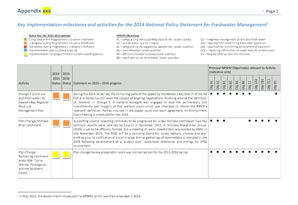
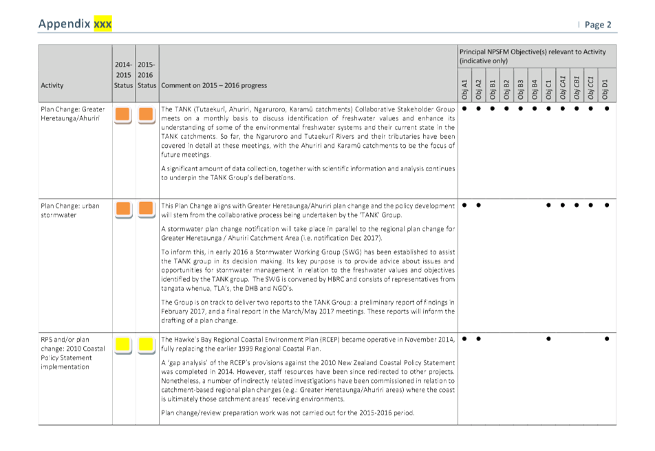
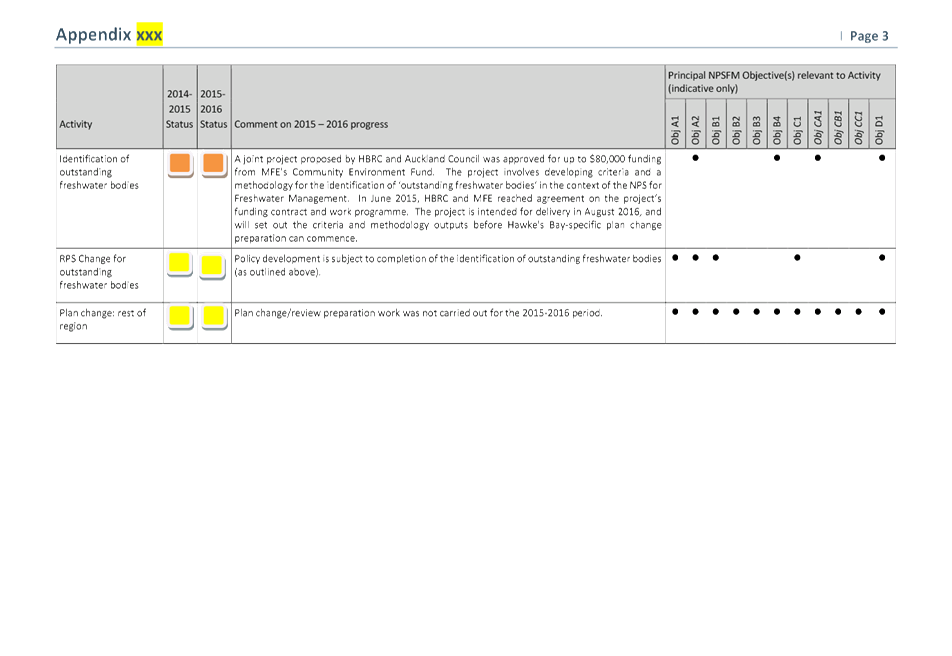
8. Highlights
include:
8.1. Progression
of a regional plan change for the Greater Heretaunga/Ahuriri catchment area
(aka the ‘TANK” catchments), with the TANK Stakeholder Group
assessing a range of policy options to inform a draft policy change which will
include input from the wider public. The project is on track to have a proposed
plan change ready for Council adoption in December 2017.
8.2. The November
2015 Regional Planning Committee sign-off of a key technical report outlining
the science of ecology and surface water for the Mohaka catchment. The report
is significant as it outlines the science pertaining to the surface water and
ecology for the catchment, as well as being communicated and shared to external
stakeholders.
8.3. Commencement
of a significant joint project with Auckland Council and funding from the
Ministry for the Environment’s Community Environment Fund aimed at developing
methodology for the identification of ‘outstanding freshwater
bodies’ in the context of the NPSFM. This project is intended for
delivery in August 2016.
8.4. Continued
involvement in negotiations with NZ Fish and Game Council and other parties on
the definition of ‘wetland’ in Plan Change 5. A wetland ecologist
was engaged to map the permanently wet margins of five wetland areas which was
intended to inform the RRMP’s ‘wetland’ definition. As
a result of ongoing disagreement on the definition, an Environment Court
hearing is scheduled for late 2016 on this matter.
Decision Making
Process
9. Council is
required to make every decision in accordance with Part 6 Sub-Part 1, of the
Local Government Act 2002 (the Act). Staff have assessed the requirements
in relation to this item and have concluded that, as this report is for
information only and no decision is to be made, the decision making provisions
of the Local Government Act 2002 do not apply.
|
Recommendations
That the Regional Planning Committee receives and notes the “National
Policy Statement for Freshwater Management - Progressive Implementation
Programme Annual Report 2015-16”, for inclusion in the
Council’s 2015-16 Annual Report.
|
Authored by:
|
Rina Douglas
Senior Planner
|
James Palmer
Group Manager Strategic Development
|
Approved by:
|
Rina Douglas
Senior Planner
|
Gavin Ide
Manager,
Strategy and Policy
|
|
James Palmer
Group Manager
Strategic Development
|
|
Attachment/s
|
1
|
Update table
for activities 2015-2016 NPSFM
|
|
|
|
Update
table for activities 2015-2016 NPSFM
|
Attachment 1
|
HAWKE’S BAY REGIONAL COUNCIL
Regional
Planning Committee
Wednesday 21 September 2016
Subject: Translating Mana Whenua
Values to Attributes for the Ngaruroro Awa
Reason for Report
1. To introduce the “Translating Mana Whenua Values to Attributes
for the Ngaruroro Awa” presentation from the working group of Ngati
Kahungunu Iwi Incorporated (NKII).
Background
2. The way land and water resources are managed in the Greater
Heretaunga and Ahuriri area is under review. The area encompasses the
Tutaekuri, Ahuriri, Ngaruroro and Karamu catchments ('TANK'), plus the
Heretaunga Plains aquifer system.
3. TANK is taking a community-based decision-making approach to work
out how these unique water bodies should be managed. The TANK Group comprises
30+ Hawke's Bay members representing a wide range of interests. This is
consistent with many approaches to develop freshwater management plans in New
Zealand.
4. There is still
much ground to cover before the Group can make well-informed decisions about
the form and content of the Plan Change - a wide range of science, cultural and
economic information is necessary to assist decisions.
5. As well as
making recommendations on values and overall objectives, there are a number of
key aspects of the Regional Plan that the TANK Group will recommend to Council.
One of these matters under consideration is the use of Mātauranga
Māori in monitoring and reporting.
6. Earlier this year NKII were contracted to conduct research which
would translate Mana Whenua values to attributes for the Ngaruroro Awa.
7. NKII members of the working group will present the findings of their
draft research to the committee meeting on 21 September, having presented to
the TANK Group the day before.
8. The final report will be submitted to the next RPC meeting, once it
has been approved by the TANK Group.
Decision Making
Process
9. Council is
required to make every decision in accordance with Part 6 Sub-Part 1, of the
Local Government Act 2002 (the Act). Staff have assessed the requirements
in relation to this item and have concluded that, as this report is for
information only and no decision is to be made, the decision making provisions
of the Local Government Act 2002 do not apply.
|
Recommendation
That the Regional Planning Committee receives and notes the draft
findings from the “Translating Mana Whenua
Values to Attributes for the Ngaruroro Awa” presentation.
|
Authored by:
|
Joyce-Anne
Raihania
Senior Planner
Maori Policy Advisor
|
|
Approved by:
|
James Palmer
Group Manager
Strategic Development
|
|
Attachment/s
There are no
attachments for this report.
HAWKE’S BAY REGIONAL
COUNCIL
Regional
Planning Committee
Wednesday 21 September 2016
SUBJECT: September 2016 Resource Management Planning Project Update
Reason for Report
1. This report provides a brief outline and update of the
Council’s various resource management projects currently underway.
Discussion
2. The projects covered in this report are those involving reviews
and/or changes under the Resource Management Act to one or more of the
following planning documents:
2.1. the Hawke's Bay Regional Resource Management Plan (RRMP)
2.2. the Hawke's Bay Regional Policy Statement (RPS) which is
incorporated into the RRMP
2.3. the Hawke's Bay Regional Coastal Environment Plan (RCEP).
3. From time to time, separate reports additional to this one may be
presented to the Committee for fuller updates on specific plan change projects.
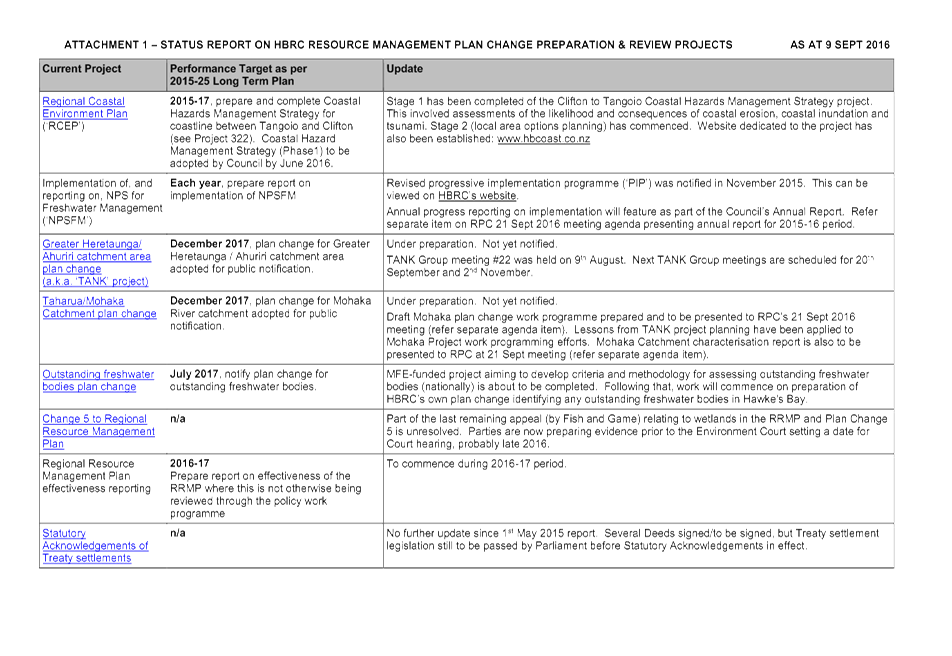
4. The table in Attachment 1 repeats the relevant parts of the resource
management planning work programme from the 2015-25 Long Term Plan.
5. Similar periodical reporting will also be presented to the Council
as part of the quarterly reporting and end of year Annual Plan reporting
requirements.
Decision Making
Process
6. Council is required to make a decision in accordance with Part 6
Sub-Part 1, of the Local Government Act 2002 (the Act). Staff have
assessed the requirements contained within this section of the Act in relation
to this item and have concluded that, as this report is for information only
and no decision is to be made, the decision making provisions of the Local
Government Act 2002 do not apply.
|
Recommendation
1. That the Regional Planning Committee
receives and takes note of the ‘September 2016 Resource
Management Planning Projects Update’ report.
|
|
Gavin Ide
Manager, Strategy and Policy
|
James Palmer
Group Manager
Strategic Development
|
Attachment/s
|
Status
Report
|
Attachment 1
|
HAWKE’S BAY REGIONAL COUNCIL
Regional
Planning Committee
Wednesday 21 September 2016
SUBJECT: August-September 2016 Statutory
Advocacy Update
Reason for Report
1. This paper reports on proposals forwarded to the Regional Council
and assessed by staff acting under delegated authority as part of the
Council’s Statutory Advocacy project between 1 August 2016 and 21
September 2016.
2. The Statutory Advocacy project (Project 196) centres on resource
management-related proposals upon which the Regional Council has an opportunity
to make comments or to lodge a submission. These include, but are not
limited to:
2.1. resource consent applications publicly notified by a territorial
authority
2.2. district plan reviews or district plan changes released by a
territorial authority
2.3. private plan change requests publicly notified by a territorial
authority
2.4. notices of requirements for designations in district plans
2.5. non-statutory strategies, structure plans, registrations, etc
prepared by territorial authorities, government ministries or other agencies
involved in resource management.
3. In all cases, the Regional Council is not the
decision-maker, applicant nor proponent. In the Statutory Advocacy
project, the Regional Council is purely an agency with an opportunity to make
comments or lodge submissions on others’ proposals. The Council’s
position in relation to such proposals is informed by the Council’s own
Plans, Policies and Strategies, plus its land ownership or asset management
interests.
4. The summary plus accompanying map outlines those proposals that the
Council’s Statutory Advocacy project is currently actively engaged in.
Decision Making
Process
5. Council is required to make a decision in accordance with Part 6
Sub-Part 1, of the Local Government Act 2002 (the Act). Staff have
assessed the requirements contained within this section of the Act in relation
to this item and have concluded that, as this report is for information only
and no decision is to be made, the decision making provisions of the Local
Government Act 2002 do not apply.
|
Recommendation
1. That the Regional Planning Committee
receives the August-September 2016 Statutory Advocacy Update
report.
|
|
Esther-Amy Powell
Planner
|
Gavin Ide
Manager, Strategy and Policy
|
|
James Palmer
Group Manager
Strategic Development
|
|
Attachment/s
|
1
|
Statutory Advocacy Map
|
|
|
|
2
|
Statutory Advocacy Update
|
|
|
|
Statutory
Advocacy Map
|
Attachment 1
|
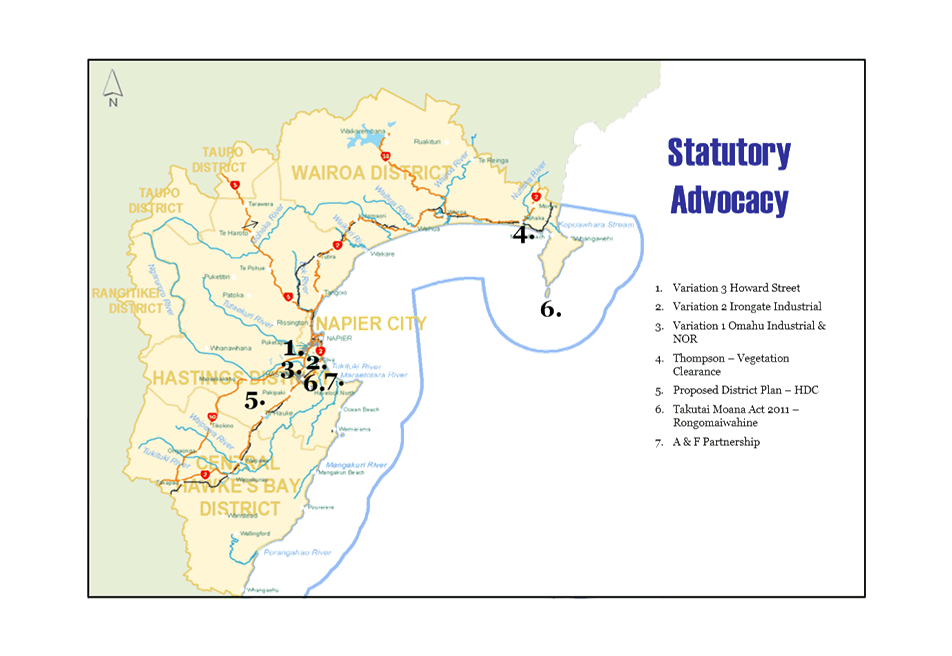
|
Statutory Advocacy Update
|
Attachment 2
|
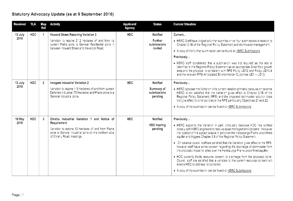
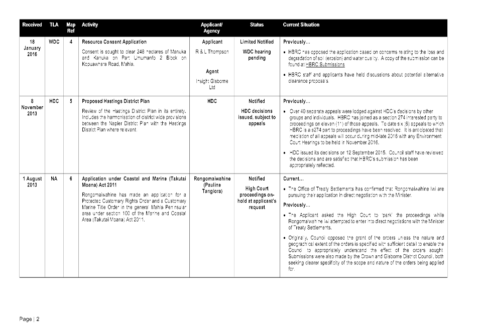
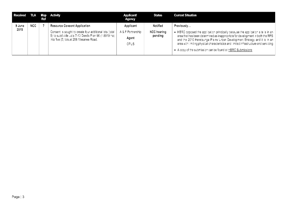
HAWKE’S BAY REGIONAL COUNCIL
Regional
Planning Committee
Wednesday 21 September 2016
SUBJECT: Minor Items Not on the Agenda
Reason for Report
This document has been
prepared to assist Councillors note the Minor Items Not on the Agenda to be
discussed as determined earlier in Agenda Item 5.
|
Item
|
Topic
|
Councillor
/ Staff
|
|
1.
|
|
|
|
2.
|
|
|
|
3.
|
|
|
|
4.
|
|
|
|
5.
|
|
|