Meeting of the Regional Planning Committee
Date: Wednesday 1 June 2016
Time: 9:00am
|
Venue:
|
Council Chamber
Hawke's Bay Regional Council
159 Dalton Street
NAPIER
|
Agenda
Item Subject Page
1. Welcome/Notices/Apologies
2. Conflict
of Interest Declarations
3. Confirmation of
Minutes of the Regional Planning Committee held on 20 April 2016
4. Matters Arising
from Minutes of the Regional Planning Committee held on 20 April 2016
5. Follow-up Items
from Previous Regional Planning Committee Meetings 3
6. Call for any Minor
Items Not on the Agenda 7
Decision Items
7. Iwi - Hapu
Engagement Plan for the Development of the Greater Heretaunga (TANK) Plan
Change 9
8. Effectiveness of
Regional Plans for managing Oil & Gas Activities 13
9. Tukituki
Implementation Principles 19
10. Regional State and Trends of
River Water Quality and Ecology 23
Information or Performance Monitoring
11. Ngaruroro Water Conservation
Order 35
12. Verbal Update on the TANK
Project
13. Verbal Presentation on the
TANK Information Portal
14. June 2016 Resource Management
Planning Project Update 49
15. March 2016 - May 2016
Statutory Advocacy Update 53
16. Presentation of Pataka - A
Resource Management Tool
17. Minor Items Not on the Agenda 59
1.
Free 2-hour on-road
parking is available on Vautier Street adjacent to the HBRC Building
2.
Public parking in the
NCC lots either side of Vautier Street cost $4 for all day parking. This cost
will be reimbursed by Council.
3.
There are limited
parking spaces (3) for visitors in the HBRC car park – entry of Vautier
Street – it would be appropriate that the “visitors” parks be
available for the members travelling distances from Waiora and CHB.
NB: Any
carparks that have yellow markings are NOT to be parked in.
Regional Planning Committee Members
|
Name
|
Represents
|
|
Karauna Brown
|
Ngati Hineuru Iwi Inc
|
|
Nicky Kirikiri
|
Te Toi Kura o Waikaremoana
|
|
Nigel Baker
|
Ngati Tuwharetoa Hapu Forum
|
|
Peter Paku
|
He Toa Takitini
|
|
Rangi Spooner
|
Mana Ahuriri Incorporated
|
|
Tania Hopmans
|
Maungaharuru-Tangitu Trust
|
|
Toro Waaka (co-chair)
|
Ngati Pahauwera Development and Tiaki
Trusts
|
|
Allen Smith
|
Te Tira Whakaemi o Te Wairoa
|
|
Alan Dick
|
Hawkes Bay Regional Council
|
|
Christine Scott
|
Hawkes Bay Regional Council
|
|
Dave Pipe
|
Hawkes Bay Regional Council
|
|
Debbie Hewitt
|
Hawkes Bay Regional Council
|
|
Fenton Wilson (co-chair)
|
Hawkes Bay Regional Council
|
|
Peter Beaven
|
Hawkes Bay Regional Council
|
|
Rex Graham
|
Hawkes Bay Regional Council
|
|
Rick Barker
|
Hawkes Bay Regional Council
|
|
Tom Belford
|
Hawkes Bay Regional Council
|
Total number of members = 17
Quorum
and Voting Entitlements Under the Current Terms of Reference
Quorum (clause (i))
The Quorum for the Regional Planning
Committee is 75% of the members of the Committee
At the present time, the quorum is 13
members.
Voting Entitlement (clause (j))
Best endeavours will be made to achieve
decisions on a consensus basis, or failing consensus, the agreement of 80% of
the Committee members in attendance will be required. Where voting is
required all members of the Committee have full speaking rights and voting
entitlements.
Number of Committee members present Number
required for 80% support
17 14
16 13
15 12
14 11
13 10
HAWKE’S BAY REGIONAL COUNCIL
Regional
Planning Committee
Wednesday 01 June 2016
Subject: Follow-up Items from
Previous Regional Planning Committee Meetings
Reason for Report
1. Attachment 1 lists the items raised at previous Regional Planning Committee
meetings that require actions or follow-ups.
2. All items indicate which RPC agenda item it
related to, who is responsible for the follow-up, and a brief status comment.
Once the items have been completed and/or reported to the Committee they will
be removed from the list.
Decision Making Process
3. Council is required to make every decision in
accordance with Part 6 Sub-Part 1, of the Local Government Act 2002 (the Act).
Staff have assessed the requirements in relation to this item and have
concluded that as this report is for information only and no decision is
required, the decision making procedures set out in the Act do not apply.
|
Recommendation
That the Regional Planning Committee receives
and notes the “Follow-up Items from Previous Regional Planning
Committee Meetings” report.
|
|
Iain Maxwell
Group Manager
Resource Management
|
James Palmer
Group Manager
Strategic Development
|
|
Liz Lambert
Chief Executive
|
|
Attachment/s
|
1
|
Follow-ups
from Previous Regional Planning Committee Meetings
|
|
|
|
Follow-ups
from Previous Regional Planning Committee Meetings
|
Attachment 1
|

HAWKE’S BAY REGIONAL COUNCIL
Regional
Planning Committee
Wednesday 01 June 2016
SUBJECT: Call for any Minor Items Not on the Agenda
Reason for Report
1. Under standing orders, SO 3.7.6:
“Where an item is not on the agenda
for a meeting,
(a) That
item may be discussed at that meeting if:
(i) that
item is a minor matter relating to the general business of the local authority;
and
(ii) the
presiding member explains at the beginning of the meeting, at a time when it is
open to the public, that the item will be discussed at the meeting; but
(b) No
resolution, decision, or recommendation may be made in respect of that item
except to refer that item to a subsequent meeting of the local authority for
further discussion.”
2. The Chairman will request any items committee members wish to be
added for discussion at today’s meeting and these will be duly noted, if
accepted by the Chairman, for discussion as Agenda Item 17.
|
Recommendations
That Regional
Planning Committee accepts the following minor items not on the agenda, for
discussion as item 17:
1.
|
|
Liz Lambert
Chief Executive
|
|
HAWKE’S BAY REGIONAL COUNCIL
Regional
Planning Committee
Wednesday 01 June 2016
Subject: Iwi - Hapu Engagement
Plan for the Development of the Greater Heretaunga (TANK) Plan Change
Reason for Report
1. The purpose of
this report is to seek the Regional Planning Committee’s endorsement of
proposed engagement with iwi/hapu for the Greater Heretaunga / Ahuriri (TANK)
plan change as described in the revised draft Engagement Plan set out in
Attachment 1.
2. Previously, the
Committee approved the Engagement Plan for other stakeholders at its February
2015 meeting and this separate, yet complementary iwi/hapu engagement plan has
been prepared in liaison with TANK mana whenua representatives.
Resource Management Act (RMA) requirements
3. Clause 3 of RMA
Schedule 1 outlines the consultation requirements during the preparation of a
proposed plan or plan change. In relation to tangata whenua, it states
that during the preparation of a proposed plan change, the local authority
concerned (i.e. HBRC) shall consult the tangata whenua of the area who may be
affected, through iwi authorities, and any customary marine title groups in the
area.
4. This engagement
plan looks to identify how HBRC will engage with tangata whenua to satisfy
those RMA requirements. Note that there are currently no customary marine title
groups in vicinity of the TANK catchments.
Hapu/Iwi Engagement Plan
5. The initial
engagement plan was developed in collaboration with Te Manaaki Taiao, a unit of
Te Taiwhenua o Heretaunga.
6. It incorporated
the consultation and engagement principles outlined in the ‘Mana
Ake’ collective Hapu Management Plan. Mana Ake was developed by Te
Manaaki Taiao under the guidance and direction of Te Runanganui o Heretaunga, a
collective of Heretaunga hapu representatives. ‘Mana Ake’ has
previously been presented to the Regional Planning Committee.
7. A first draft
of the iwi/hapu engagement plan was considered by Te Runanganui o Heretaunga
and feedback has been incorporated into the new document. A draft was also
considered by the TANK Mana Whenua Group which comprises hapu members of the
TANK Collaborative Stakeholder Group.
8. The TANK area
includes the rohe of Te Taiwhenua o Te Whanganui A Orutu, Mana Ahuriri
Incorporated, He Toa Takitini and Maungaharuru-Tangitu Trust. The revised
draft engagement plan (Attachment 1) has been sent to those organisations and
HBRC planning staff will be arranging meetings with those groups to discuss the
draft engagement plan.
9. Feedback on the
earlier engagement plan acknowledged concerns that the TANK Collaborative
Stakeholder Group (the TANK Group) did not include full representation of iwi
and hapu and that those participating who are staff of Ngati Kahungunu Iwi Incorporated
and Te Taiwhenua o Heretaunga were not in a position to speak on behalf of
hapu. It is hoped that the second version engagement plan will enable the views
of hapu to be expressed so that they can be conveyed to the TANK Group by
iwi/hapu representatives, as well as the HBRC policy team conveying those views
directly to the Regional Planning Committee.
10. In recent weeks, Mr Wayne
Ormsby, as a representative of the Mana Whenua roopu has been working closely
with HBRC planning staff to further develop partnership aspects of the second
draft version of the engagement plan.
11. The second version of the
iwi/hapu engagement plan was presented to the TANK Mana Whenua representatives
on Tuesday 24 May. Deadlines for production of the RPC’s meeting
agenda meant feedback from that 24 May meeting is not included in this paper,
but will be outlined at the 1 June RPC meeting.
Decision Making
Process
12. Council
is required to make every decision in accordance with the requirements of the
Local Government Act 2002 (the Act). Staff have assessed the requirements
in relation to this item and have concluded:
12.1. The decision
does not significantly alter the service provision or affect a strategic asset.
12.2. The use of
the special consultative procedure is not prescribed by legislation.
12.3. The decision
does not fall within the definition of Council’s policy on significance.
12.4. The persons affected by this
decision are tangata whenua affected by proposed policy and plan change for the
management of natural and physical resources in the Greater Heretaunga /
Ahuriri area.
12.5. Options
include adjusting the level of engagement, however it is considered that the
proposed level of engagement is appropriate given the number of hapu in this
area.
12.6. The decision
is not inconsistent with an existing policy or plan.
12.7. Given the
nature and significance of the issue to be considered and decided, and also the
persons likely to be affected by, or have an interest in the decisions made,
Council can exercise its discretion and make a decision without consulting
directly with the community or others having an interest in the
decision.
|
Recommendations
1. That the Regional Planning Committee receives and notes the
“Iwi - Hapu Engagement Plan for the Development of the Greater
Heretaunga (TANK) Plan Change” and staff report.
2. The Regional Planning Committee recommends that Council:
2.1. Agrees that the decisions to be made are not significant under the
criteria contained in Council’s adopted Significance and Engagement
Policy, and that Council can exercise its discretion and make decisions on
this issue without conferring directly with the community.
2.2. Endorses the Iwi - Hapu Engagement Plan
for the Development of the Greater Heretaunga (TANK) Plan Change, subject to:
2.2.1. finalisation by staff and the inclusion of any minor amendments
arising from further iwi/hapu feedback
2.2.2. any material proposed amendments being brought back to the
Regional Planning Committee for further recommendations.
|
|
Joyce-Anne Raihania
Senior Planner
Maori Policy Advisor
|
Gavin Ide
Manager, Strategy and Policy
|
|
James Palmer
Group Manager
Strategic Development
|
|
Attachment/s
|
1
|
Draft
Iwi-Hapu Engagement Plan for Development of the TANK Plan Change
|
|
Under
Separate Cover
|
HAWKE’S BAY REGIONAL
COUNCIL
Regional
Planning Committee
Wednesday 01 June 2016
Subject: Effectiveness of
Regional Plans for managing Oil & Gas Activities
Reason for Report
1. The purpose for
this paper is to present the findings of a review of the effectiveness of
Regional Resource Management Plan (RRMP) provisions to manage actual and
potential effects of oil and gas related activities in the Hawke's Bay region.
Background
2. In June 2014
the Parliamentary Commissioner for the Environment (PCE) released her report
titled “Drilling for oil and gas in New Zealand: Environmental
oversight and regulation” (“the PCE’s report”). The
PCE’s report made a number of recommendations to regional councils for
the more effective management of oil and gas exploration and production
activity.
3. Shortly
following release of the PCE’s report, Council, in its 2015-25 Long Term
Plan signalled that before 30 June 2016, it would:
3.1. complete a
report on the effectiveness of the RRMP and Regional Coastal Environment Plan
(RCEP) in relation to managing the effects of oil and gas exploration and
development
3.2. complete a
report to the Regional Planning Committee to consider whether a limited scope
Regional Plan Change is necessary and appropriate to address any relevant
recommendations from the Parliamentary Commissioner for the Environment’s
2014 report.
4. The following
two reports were commissioned to address the Long Term Plan commitments above:
4.1. “Policy
Review: Oil and Gas Exploration Development for HBRC” commissioned
from van Voorthuysen Environmental Limited (Attachment 1); and
4.2. “Review
of the oil and gas exploration in the Hawke’s Bay region & assessment
of relevance of PCE’s recommendations for Hawke's Bay regional
plan” commissioned from Environmental Management Services Limited
(EMS Limited) (Attachment 2).
5. Both reports
(collectively referred to as “the reports”) are attached to this
briefing paper. Key points arising from each of these reports are
discussed following.
The Reports
6. The van
Voorthuysen report was completed in October 2015. It reviewed the adequacy of
the existing plan framework at a high-level as against the PCE’s
recommendations. That report’s scope was not asked to examine the merits
of the PCE’s recommendations. Subsequently, the report concluded by
saying that if the Council wished to give effect to the
PCE’s recommendations, then a limited scope plan change was necessary.
7. Although this
report was helpful to a certain extent, it did not adequately answer the
question of whether or not the PCE’s recommendations were appropriate
when taking into account both the unique geology of Hawke’s Bay and our
current planning framework.
8. More recently,
HBRC contracted EMS Limited to carry out a more in-depth assessment (Attachment
2) of two matters.
8.1. Firstly, an
overview of the history and current state of oil and gas exploration in the
East Coast Basin (ECB), including within Hawke’s Bay; and a geological
assessment of Hawke’s Bay as it relates to oil and gas reserves and
prospectivity.
8.2. Secondly,
consideration of whether or not the RRMP and associated consent decision-making
processes already appropriately address matters identified in the PCE’s
report. This examination would reveal the extent to which the PCE’s
recommendations remain relevant in the Hawke's Bay planning context.
9. As a result of
their examination, EMS Limited made several findings; the key findings being:
9.1. The
PCE’s recommendation 2e states that councils should “classify
drilling, fracking and waste disposal as ‘discretionary
activities’”. EMS Limited are of the view that the existing
rules in the RRMP are adequate as the key activities described by the PCE are
already discretionary activities with the one exception being for the process
for obtaining a bore permit, which is a controlled activity (switching to
restricted discretionary if basic conditions are not met) and is not
differentiated in the RRMP’s rules between drilling for water or drilling
for oil and gas.
9.2. The
inclusion of two further ‘Matters for Control’ in RRMP Rules 1
& 2 (those matters being “type of drilling fluid” and
“casing”).
9.3. The
possibility for the development of controls specific to oil and gas drilling
within the area of the Heretaunga and Ruataniwha Plains aquifers. This
suggestion also relates to the PCE’s recommendation 2b that councils
“identify areas where oil and gas drilling can and cannot take
place.” The RRMP does not currently identify areas where oil and gas
drilling should be prohibited (although Hastings District Council have taken
steps to do so as a land use control over the unconfined Heretaunga Plains
aquifer by making oil and gas exploration, extraction and production in this
area a prohibited activity). EMS Limited stated that they are
“reluctant to recommend a similar action by the regional council in the
absence of sound evidence that the effects of drilling either can or cannot be
adequately managed and contained.”
Analysis
10. The current discretionary
status for drilling, fracking and waste disposal provides HBRC adequate control
(through the ability to set consent conditions) but does not automatically
prescribe public notification and a hearings process. Requiring public
notification and hearings for the activity of drilling a hole in the ground for
oil and gas, and not for water, may be difficult to justify on the grounds of
environmental risk management as the activity itself (i.e. drilling a bore) has
what would be normally considered less than minor effects.
11. This is not to be confused
with other activities associated with subsequent use of the bore
(e.g. abstraction of water and/or discharge of contaminants into the ground).
12. It is possible that a
section 32 analysis necessary for supporting a plan change will reveal that the
cost to applicants of making this activity discretionary outweigh the benefits.
The PCE’s recommendation about discretionary activity status is related
to the PCE’s recommendation 2e which recommends councils “make
explicit the circumstances when consents will be notified”. The existing
regional plan already has guidance (in the Rule tables and Sections 8.2.2 and
8.2.3 of the RRMP) for when consents for various activities should be
notified. There is also a well-developed body of RMA case law about the
notification of resource consent applications.
13. Staff recommend the
question of discretion for the drilling of bores and the associated level of
public notification and participation in the decision-making process be
considered as part of a review of the RRMP in 2020-21, or at any other earlier
plan change as it presents.
14. EMS Limited has also
recommended that the RRMP is amended to include “type of drilling”
and “casing” as specific matters for control in relation to
consents for bore drilling. Staff believe it would indeed be useful to be more
explicit about the types of matters our consenting processes cover, but that
this is a relatively minor matter as in practice the well casing and types of
drilling fluid used would be subject to HBRC oversight even under the rules at
present. On this basis we recommend these minor changes be considered as part
of a review of the RRMP in 2020-21, or at any other earlier plan change as it
presents.
15. In relation to the
possibility of controls for drilling within the area of the Heretaunga and
Ruataniwha aquifers, staff acknowledge public concerns previously expressed,
particularly by the ‘Guardians of the Aquifer’ group, about
drilling in or near the aquifers. If a precautionary approach was
favoured by the Regional Planning Committee, the RPC might wish to recommend to
the Council that a prohibited activity status be investigated for oil and gas
drilling on or near the aquifers.
16. It should be noted that
New Zealand Petroleum and Minerals (NZP&M) have sought to be sensitive to
public concerns and had excluded the known aquifers from their last Block Offer
process in the area. At present HBRC staff are aware of no current oil and gas
exploration permits over the aquifer area.
17. Staff agree with EMS
Limited’s finding that the current decrease in oil and gas exploration
activity, along with the new Hastings District Council controls, allows time
for a more considered assessment of this issue and the development of an
appropriate policy response and be considered as part of a review of the RRMP
in 2020-21, or at any other earlier plan change as it presents.
18. It is also recognised that
the PCE made a range of recommendations that are less contentious and more
mechanical in terms of council processes, for example Recommendation 2d:
“require consent applications to be ‘bundled
together’” and Recommendation 2f: “conduct joint
hearings whenever possible.” Those types of consent processes can
already occur by HBRC and territorial authorities as a matter of course when
relevant – they do not require a plan change to be achieved.
19. Several other
recommendations from the PCE also don’t require changes to the RRMP and
are rather a question of council practice, such as Recommendation 5: “require
regional councils to be responsible for HSNO on oil & gas sites” and
Recommendation 2c: “set core requirements for environmental
monitoring”. Staff will examine these issues if and when interest in
drilling for oil and gas in the region grows again.
20. Additionally, the PCE also
recommends that councils “identify and plan for cumulative
effects”. With respect to using water resources for drilling
activity current provisions in the RRMP adequately provide for cumulative
effects to be managed. Landscape impacts and the cumulative effect on noise,
dust and light from a large number of drilling sites and associated
infrastructure, such as experienced in Taranaki, are the domain of territorial
authorities and their district plans. However, in the near term there is no
prospect of this being an issue for the Hawke’s Bay region. If and when
such a prospect appears likely, HBRC staff will engage with counter parts in
territorial authorities to ensure these cumulative effects are appropriately
managed.
21. Finally, the PCE also
recommended that councils “consider how solid waste from the east
coast can be disposed of”. The RRMP already classifies disposal
of solid drilling waste as a discretionary activity, so can be managed on a
consent application by application basis. Given the limited prospects for a
resurgence in drilling and exploration activity in the Hawke’s Bay region
within the next decade staff recommend that work on a plan to manage large
volumes of ongoing drilling waste be considered a low priority for HBRC at this
time.
Central
Government response to PCE’s report and recommendations
22. In recent weeks, HBRC
planning staff made renewed enquiries to Ministry for the Environment (MfE)
officials about Government’s possible response to the PCE’s report,
particularly her recommendation for a National Policy Statement. MfE
officials have advised HBRC planning staff that work has stalled on national
policy direction for the time being due to a lack of resource.
23. Given this, there clearly
remains a degree of uncertainty about what and when any form of national direction
on oil and gas-related regulation might emerge. Staff will maintain
regular liaison with MfE officials on any central government policy direction
proposals regarding regulation of oil and gas exploration and development
activities as it might relate to functions of regional councils.
Conclusions
24. Based on the detailed
analysis contained in the reports, it is considered that the RRMP already
sufficiently addresses the PCE’s substantive recommendations. We consider
there to be no immediate haste to change the RRMP. This is reinforced by EMS
Limited’s analysis which demonstrates that geological unsuitability of
large parts of Hawke’s Bay for oil and gas drilling, and sharp decline in
fortunes in the industry means that there is adequate time for a considered
assessment of whether or not a plan change is still needed.
25. As noted above, the next
scheduled review of the RRMP is in 2020-21. This would be a suitable time to
assess the merits of amending the RRMP. Alternatively, there may be other
earlier plan changes which are also considered appropriate. In addition, these
reports are not section 32 reports. Therefore, a full evaluation under
section 32 of the Resource Management Act to assess the costs and benefits of a
plan change is still required.
26. We would also make several
general observations regarding the PCE’s report. Firstly, we note that
the recommendations are occasionally unclear. This means that both reports have
had to speculate on the actual intent behind the recommendations. Additionally,
the PCE has advocated for a national response to oil and gas issues in the form
of a National Policy Statement – the form and timing of which remains
very uncertain.
27. Oil and gas matters also
sit within the broader context of the development of an Energy Strategy for
Hawke’s Bay. This strategy will consider aspirations for energy usage and
advancement of renewables in the region. The strategy is not anticipated to
have any significant impact upon the matters contained in this report.
Public opinion
28. The issue of oil and gas
exploration in Hawke’s Bay has generated significant public interest.
Common concerns relate to potential impacts upon the aquifers from drilling and
fracking activities, and also the levels of regulatory control placed upon such
activities.
29. The Guardians of the
Aquifer hold particular concerns that drilling activities will contaminate
drinking supplies. They are seeking a discrete plan change under
the RRMP that would change drilling on or near the water catchment from a controlled
activity to a prohibited activity.
Financial and Resource Implications
30. There are a range of
implications if it was deemed necessary to commence an immediate discrete plan
change on any or all of the matters discussed in this report. At present
there is no budget allocated for such an undertaking. However, there is
approximately $150k left in the budget which was set originally aside for
assessment of the PCE’s report and is currently in use for preparation of
a Regional Energy Strategy. Furthermore, increased resource within the
Strategic Development Group to carry out this work.
31. As noted above, a full
section 32 analysis would be required to be undertaken in support of any
regional plan change. This would include a thorough evaluation of the
appropriateness, costs and benefits of such a plan change. Furthermore, it is
not guaranteed that a section 32 evaluation will find in favour of a plan
change proposition. It should also be noted that the reports by van
Voorthuysen Ltd and EMS Ltd are a helpful start, but are insufficient alone to
pass as a s32 analysis if a plan change was indeed to be prepared and notified.
32. Finally, at this stage it
is difficult to provide an estimate of how much any such plan change would
cost. This is determined by the scale and complexity of such a proposed change,
alongside its pace of preparation relative to other workstreams already
prioritised and resourced.
Decision Making
Process
33. Council
is required to make a decision in accordance with the requirements of the Local
Government Act 2002 (the Act). Staff have assessed the requirements in
relation to this item and have concluded:
33.1. The decision
does not significantly alter the service provision or affect a strategic asset.
33.2. The use of
the special consultative procedure is not prescribed by legislation.
33.3. The decision
does not fall within the definition of Council’s policy on significance.
33.4. The persons affected by this
decision are those persons with an interest in sustainable management of the
region’s natural and physical resources.
33.5. Options
include reconsidering the need for a regional plan change to address some or
all of the recommendations made by the PCE, and EMS Limited; and prioritising
any such plan change as an immediate need or something to be considered as part
of the 2020/21 review of the RRMP.
33.6. The decision
is not inconsistent with an existing policy or plan. The 2015-25 Long
Term Plan does not state a regional plan change will be prepared, rather that a
review of the existing plan provisions’ effectiveness will be reported on
by 30 June 2016.
33.7. Given the
nature and significance of the issue to be considered and decided, and also the
persons likely to be affected by, or have an interest in the decisions made,
Council can exercise its discretion and make a decision without consulting
directly with the community or others having an interest in the
decision.
|
Recommendations
1. That the Regional Planning Committee receives and notes the:
1.1 “Policy Review: Oil and Gas Exploration Development for
Hawke’s Bay Regional Council” report prepared
by van Voorthuysen Environmental Limited dated October 2015
And the
1.2 “Review of Oil and Gas Exploration in the Hawke's Bay Region
& Assessment of Relevance of PCE’s Recommendations for Hawke's Bay
Regional Plan” report prepared by
Environmental Management Services Limited dated May 2016.
2. The Regional Planning Committee recommends that Council:
2.1. Agrees that the decisions to be made are not significant under the
criteria contained in Council’s adopted Significance and Engagement
Policy, and that Council can exercise its discretion and make decisions on
this issue without conferring directly with the community.
2.2. Agrees that the current provisions of the Regional Resource
Management Plan adequately address the Parliamentary Commissioner for the
Environment’s substantive recommendations and that no immediate plan
change is required to Hawke's Bay regional plans.
2.3. Agrees that an assessment of a plan change is not necessary until
the 2020-21 review of the Regional Resource Management Plan, or an earlier
related plan change as it presents.
|
|
Rina Douglas
Senior Planner
|
Gavin Ide
Manager, Strategy and Policy
|
|
James Palmer
Group Manager
Strategic Development
|
|
Attachment/s
|
1
|
van
Voorthuysen Plan Effectiveness Report
|
|
Under
Separate Cover
|
|
2
|
EMS Review of
Oil and Gas Exploration in Hawke's Bay
|
|
Under
Separate Cover
|
HAWKE’S BAY REGIONAL
COUNCIL
Regional
Planning Committee
Wednesday 01 June 2016
Subject: Tukituki Implementation
Principles
Reason for Report
1. Council is soon
to consider a paper that describes the work occurring and the work required to
achieve implementation of the Change 6 policy and rule framework for the
Tukituki catchment. To frame this discussion it is important to consider
the overarching principles that will apply to the approach taken to allow staff
to deal with the inevitable ambiguity that will arise in this journey.
Discussion
2. Over the past
12 months staff have been working through the development of a working document
that outlines the intended approach to implementation of the broad policy and
rule frame work embodied in Change 6 for the Tukituki catchment. This
document is deliberately entitled Working Towards Implementation as it reflects
that the formal Implementation Plan was required by Policy TT16 to be delivered
by the end of 2014 but for a variety of reasons this was a timeframe that was
ever going to be achieved.
3. Staff are of
the view that the final and comprehensive Implementation Plan should be
completed at the latest in early to mid-2018 to allow the implications of this
to Councils work plan to be understood and then adequately resourced through
the 2018-2028 Long Term Plan.
4. In developing
this work it has become evident that aspects of the framework are clear and are
able to be easily developed into an approach and that there are other aspects
that are at best ambiguous and the approach to implement are uncertain and
unclear. Staff are comfortable with this challenge.
5. In developing
an approach for the matters that are ambiguous decisions will need to be made
and approaches developed. Staff are seeking guidance from Council on a
range of overarching principles that will guide and shape the thinking and
discussions with external parties as we continue to develop the formal
Implementation Plan.
6. We acknowledge
that the principles may need to adapt over time and/or be added to as we
further understand the challenges and risks/opportunities in various approaches
to implementing this policy. This paper is intended to outline the
thinking of staff thus far and to seek feedback on what is missing or needed to
be improved.
The Principles
7. The Cambridge
English dictionary defines a principle as, a basic idea or rule that
explains or controls how something happens or works. Staff envisage
that the principles would explain or control how the approach to policy and
rules for the catchment are put into practise, how they are enforced and how
they are developed.
8. Principles
identified are:
8.1. We are
adaptive and we will innovate – much of the policy we understand well
and the approaches are prescriptive and clearly laid out. Much of it is
not so and will require thought and discussion to find the right
approach. This will require us to be flexible (adaptive) and to look for
alternatives (innovate).
8.2. We aim to
be enabling – within the purpose of the RMA it promotes sustainable
management and sustainable management allows for the use of natural and
physical resources to enable communities to provide for social, cultural and
economic wellbeing’s while ensuring sustainability, life supporting
capacity and the management of effects. The fact that
the RMA is intended to be an enabling piece of legislation is therefore important
and a crucial principle.
8.3. We
recognise that landowners and occupiers are critical for making a difference –
the vast majority of the actions (either regulatory or non-regulatory) required
to achieve policy outcomes for this catchment need to be ‘delivered’
by landowners and occupiers. They are the critical piece of the puzzle to
successful implementation and therefore effectiveness of the policy.
8.4. We are
outcome focused – throughout the implementation journey it is
important that we retain a focus on the big picture and what the policy seeks
to achieve, the objectives. If we continually ask the question,
‘will this take us towards the desired outcome (objective)’ as we
make choices.
8.5. We will
focus on areas of risk that have high initial return – our current
understanding of the catchment and the water quality issues clearly identifies
where the priorities are and where we should focus our efforts. This
approach, to prioritise where we focus our efforts is a key principle as we
build capability and develop the work programme
8.6. We will
not drive people out of business – the policy and rule framework for
the catchment will require a change to the way that some enterprises are
managed. This has the potential to impact income and the profitability of
an enterprise. We do not believe that the Board of Inquiry, nor Council
would intend that the implementation of PC6 in the catchment unnecessarily
drove people out of business. It is accepted that business approaches may
need to change and the introduction of Industry Good Practise will incur cost,
but that this should not be required to such a level as to make a business
unprofitable thereby driving people out of business.
8.7. Our
communication is open and honest – it is important that we communicate
openly with landowners and occupiers, tangata whenua and the broader community
about our success and failures. In doing so we look to create an
environment of continual improvement and acceptance that we may need to make
mistakes to move forward.
8.8. Our
solutions/approaches are relevant, enduring and workable – given that
some aspects of the policy implementation are unclear and we need to work
through how these will work solutions and new approaches are inevitable.
In creating new approaches and solutions we should be mindful that they should
be able to be continued to be resourced and supported by Council and
landowners/occupiers so that they continue and remain effective.
8.9. We
recognise tangata whenua as a partner in implementation – Policy TT16
requires that we establish and maintain a special relationship with iwi and
hapu within the catchment to develop the implementation plan and ongoing
monitoring of cultural values and mauri. In order that we do this well we
will require a solid and enduring relationship with Maori within the catchment.
9. We recognise
that other stakeholder groups can contribute knowledge, resources and
processes, and we will partner with these groups – There are a broad
range of groups, both statutory and non-statutory who have an interest in the
successful implementation of policy. We should work constructively with
them and use their knowledge to improve our approaches where appropriate.
Decision Making
Process
10. Council
is required to make every decision in accordance with the requirements of the
Local Government Act 2002 (the Act). Staff have assessed the requirements
in relation to this item and have concluded:
10.1. The decision does not
significantly alter the service provision or affect a strategic asset.
10.2. The use of the special
consultative procedure is not prescribed by legislation.
10.3. The decision does not
fall within the definition of Council’s policy on significance.
10.4. The persons affected by
this decision are all persons with an interest in the management of the
Tukituki catchment.
10.5. The decision is not
inconsistent with an existing policy or plan.
10.6. Given the nature and
significance of the issue to be considered and decided, and also the persons
likely to be affected by, or have an interest in the decisions made, Council
can exercise its discretion and make a decision without consulting directly
with the community or others having an interest in the decision.
|
Recommendations
1. That the Regional Planning Committee:
1.1. Receives and notes the “Tukituki Implementation
Principles” report
1.2. Identifies any principles that are missing or that need to be
improved.
2. The Regional Planning Committee recommends that Council:
2.1. Agrees that the decisions to be made are not significant under the
criteria contained in Council’s adopted Significance and Engagement
Policy, and that Council can exercise its discretion and make decisions on
this issue without conferring directly with the community and persons likely
to be affected by or to have an interest in the decision.
2.2. Subject to matters raised at the RPC meeting, adopts the Tukituki Implementation Principles for development of the PC6
implementation plan.
|
|
Iain Maxwell
Group Manager
Resource Management
|
|
Attachment/s
There are no
attachments for this report.
HAWKE’S BAY REGIONAL
COUNCIL
Regional
Planning Committee
Wednesday 01 June 2016
Subject: Regional State and
Trends of River Water Quality and Ecology
Reason for Report
1. This report
provides the Committee with three technical State of the Environment reports
and seeks their recommendation to Council for formal approval for publication
and release. The draft reports have been distributed to Councillors and
Regional Planning Committee members in hard copy only, and will be available
upon request once they have been approved for publication by Council and
finalised.
2. The Council
undertakes routine water quality and ecology monitoring around the region to
assess the current state of freshwater resources, and identify whether changes
in key parameters are occurring over time.
3. State of the
Environment monitoring and reporting is a key statutory function of the
Regional Council, and the parameters we monitor help us assess whether the life
supporting capacity of the waterways is being maintained. Parameters examined
include the physical and chemical attributes of the waterways such as nutrient
levels (nitrogen and phosphorus), water clarity, suspended sediment, and
dissolved oxygen levels. Biological attributes such as faecal bacteria,
periphyton (slime algae) and macroinvertebrate communities are also examined.
4. At a broad
scale, the information can be used to assess policy effectiveness. The
monitoring is of particular interest to tangata whenua, our partners and other
stakeholders, as well as interested members of the general community. State of
the Environment information is important to inform proposed policy changes, and
serves as a contextual base to assess potential impacts of ongoing consent
applications.
5. Here, water
quality and ecology information collected from State of the Environment
Monitoring programmes between January 2004 and December 2013 is provided for
three sub regions:
5.1. Waikare,
Aropaoanui and Esk
5.2. Wairoa and
Northern Coastal
5.3. Porangahau
and Southern Coastal
6. Key points of
concern that have emerged from the SOE monitoring are:
6.1. Significant
deteriorating trends in E coli at four sites in the Porangahau and Southern
Coastal catchments
6.2. Mahiaruhe and
Sandy Creek nutrient levels remain high, with TN levels significantly
increasing in the Mahiaruhe (downstream of Lake Tutira)
6.3. Waingongoro
Stream stands out as having noticeably high nutrient levels
6.4. Widespread
sediment related issues throughout the Porangahau, Wairoa, Northern Coastal and
Southern Coastal catchments
Waikare, Aropaoanui and Esk Catchments:
State and Trends of River Water Quality and Ecology
7. This report
summarises states and trends in river water quality and ecology in the Waikari,
Aropaoanui and Esk catchments. The report is 1 of 6 State of the Environment
(SOE) reports for the Hawke’s Bay region summarising river water quality
and ecology data. The reports form the detailed regional 5 yearly review of
surface water quality and ecology and are an update from the previous round of
reports completed in 2009.
8. The combined
Esk, Aropaoanui and Waikari catchments form the smallest of the sub regions in
this technical report series, covering a total area of 761 km2, with
the Waikari the largest (at 324 km2) and Aropaoanui the smallest
(168 km2) of the 3 catchments.
9. There are
currently 7 SOE monitoring sites in the Esk, Aropaoanui and Waikari catchments,
which were used for analyses in this report:
9.1. Two sites on
the Esk River: at Berry Road in the upper catchment and at Waipunga Bridge on
the lower River
9.2. Three sites
in the Lake Tutira/ Aropaoanui catchment: at Sandy Creek, which used to flow
into the lake but is now diverted directly to the lake outlet, the Mahiaruhe
Stream, where the second monitoring site is located and on the lower Arapaoanui
River, just inland from Waipatiki Beach
9.3. Two sites in
the Waikari catchment: on the Anaura Stream, an upper catchment tributary and
on the lower Wakari River mainstem.
10. Water quality and
ecological indicators monitored as part of the SOE monitoring programme may be
considered in the following groups.
10.1. Microbiological water
quality indicators, such as Escherichia coli (E. coli), which provides
an indication of the level of health risk to recreational users of the water
10.2. Basic physico-chemical
indicators, such as temperature, dissolved oxygen and pH
10.3. Indicators associated
with the visual appearance of the water, such as visual water clarity and
turbidity
10.4. Toxicants, such as
nitrate-nitrogen and ammoniacal nitrogen
10.5. Nutrients, such as
nitrogen and phosphorus, as controlling factors, or indicators of risk of
eutrophication (excessive plant/algae growth)
10.6. Biological indicators of
eutrophication (periphyton biomass) and ecological health (macroinvertebrate
communities).
11. The various water quality
and ecological indicators were compared with appropriate environmental
guidelines and trigger values to provide an indication of the state of water
quality. Statistical analyses of trends through time were performed to
determine whether the water quality indicators have been improving or
degrading. For the relevant indicators, and where data were available, the
various indicators were compared with the Regional Plan (RRMP) Guidelines, and
with the National Policy Statement for Freshwater management (NPS-FM) (2014)
Attribute States. Monitoring data collected during the 2004-2013 period
indicate the following:
Microbiological
water quality
12. All 7 monitoring sites
fall into the NPSFM “A” Attribute State, indicating that water
quality is generally suitable for secondary (e.g. wading, boating) contact
recreation at all sites across the Esk, Aropaoanui and Waikari catchments. All
7 sites are also generally suitable for primary contact recreation, with 4 sites
presenting a low risk (NPSFM “A” grade), and 3 (Sandy Creek,
Mahiaruhe Stream and the Aropaoanui River) presenting a moderate risk (NPSFM
“B” grade) to water users.
Dissolved
Oxygen
13. Data available do not
point to any significant issues associated with dissolved oxygen (DO)
concentration or saturation at any of the sites, although it should be noted
that the data are limited to ‘spot’ measurements, which are
unlikely to capture the daily minima.
Water
clarity and turbidity
14. Water clarity is generally
relatively low in the Esk, Aropaoanui and Waikari catchments. Water clarity
meets the ANZECC guideline for recreational waters of 1.6 m only at the
Aropaoanui River and the Waikari River. Sandy Creek and the Mahiaruhe Stream
have the worst water clarity of all sites in this sub-region.
15. The sites examined in this
study rank in the middle of other sites in the Hawke’s Bay region for
water clarity and turbidity.
16. A deterioration in water
clarity (black disc) over time was detected at only 1 site (Mahiaruhe Stream)
while deteriorating trends in turbidity (i.e. an increase over time) were
detected at 3 sites, including the Esk River at Berry Road, Mahiaruhe Stream
and the Aropaoanui River.
Toxicants
17. Nitrate nitrogen and
ammoniacal nitrogen concentrations were always low at all sites, well below
guideline values indicating that the risk of toxic effects from either nitrate
or ammonia can be considered low at all SOE monitoring sites in the Esk,
Aropaoanui and Waikari catchments. All sites fall within the NPSFM
“A” Attribute State for nitrate and “A” or
“B” Attribute State for ammonia.
18. Nitrate concentrations
improve (i.e., reduce) over time at the 2 sites in the Waikari catchment, with
no change at any of the sites within the other 2 catchments.
Nutrients
19. Nutrient concentrations
vary in the following ways.
19.1. Nitrogen concentrations,
both Total Nitrogen (TN) and Dissolved Inorganic Nitrogen (DIN), were generally
moderate and better than the relevant ANZECC trigger values, with the exception
of Sandy Creek and the Mahiaruhe Stream
19.2. Median Total Phosphorus
(TP) concentrations were better than the ANZECC trigger values at all sites
except Sandy Creek and Mahiaruhe Stream. However, only the Anaura Stream was
better than the ANZECC trigger value for Dissolved Reactive Phosphorus (DRP)
concentrations
19.3. The Anaura Stream had
the lowest nutrient (N and P) concentrations of all sites
19.4. Sandy Creek and the
Mahiaruhe Stream had the highest nutrient concentrations (both nitrogen and
phosphorus), were often worse than ANZEEC trigger values and RRMP guidelines
19.5. Nutrient concentrations
at the 2 Esk River sites were very similar, indicating no change in nutrient
status along the course of the Esk River
19.6. DIN/DRP ratios suggest
co-limited conditions occur at all sites except the Aropaoanui River and the
Anaura Stream. Nitrogen-limited conditions were likely to occur at times in the
Aropaoanui River, whilst a mix of co-limited and P-limited conditions were
likely to occur in the Anaura Stream. In Sandy Creek and the Mahiaruhe Stream,
any nutrient limitation was likely to be very weak or absent (unlimited
conditions). By contrast, moderate to strong co-limitation of periphyton growth
was likely in the Aropaonui, Esk and Waikari main stems. Strong nutrient
limitation of periphyton growth (a mix of co- and P-limited conditions) was
likely in the Anaura Stream.
20. Compared with other SOE
sites in the region, most Esk, Aropaoanui and Waikari sites ranked in the
bottom 40% for the region for both DIN and DRP.
21. Nutrient concentrations
were generally stable over time across the study area, although improvements in
DIN were detected in the Aropaoanui River, Anaura Stream and Waikari River. No
changes in DRP (improvements or deterioration) occurred at any sites in the
Esk, Aropaoanui and Waikari catchments. Significant improvements in TN and TP
were observed, but only in the Esk River at Berry Road and Anaura Stream, and
for TP in the Aropaoanui River. TN concentrations significantly increased in the
Mahiaruhe Stream, which is the combination of Sandy Creek and the outlet of
Lake Tutira.
Biological
indicators
22. MCI scores at both
Esk River sites, in the Aropaoanui River and the Anaura Stream were indicative
of good water quality, while those in Sandy Creek and the Mahiaruhe Stream and
the Waikari River had in-stream macroinvertebrate communities indicative of
‘fair’ water quality. The Mahiaruhe Stream had the worst median MCI
score and was the only site where MCI scores indicative of ‘poor’
water quality (<80) were observed.
23. Periphyton biomass
was generally under both the 120 mg/m2
‘recreational’ and 50 mg/m2 ‘biodiversity’
thresholds in the Anaura Stream, Sandy Creek and Aropaoanui River, indicating
good water quality. However, Sandy Creek and the Mahiaruhe Stream are unsuited
to periphyton development.
24. Both sites on the Esk
River and the Waikari River site had higher median periphyton biomass levels,
exceeding the threshold for the protection of aquatic biodiversity values, but
within or just exceeding the threshold for the protection of aesthetics and
recreational values. At all 3 sites, periphyton biomass at times largely
exceeded the 120 mg/m2 ‘recreational’ threshold.
The highest levels (represented by 90th percentile whiskers) were
observed in the Waikari River.
25. Data at all sites were
limited to annual measurements (1 to 5 annual measurements available at each
site), and are insufficient to provide a robust indication of periphyton
biomass patterns at these sites, particularly if, or how often
“nuisance” levels of periphyton growth occur.
Wairoa and Northern Catchments: States and
Trends of River Water Quality and Ecology
26. This report summarises
states and trends in river water quality and ecology in the Wairoa River
catchment. The report is 1 of 6 State of the Environment (SOE) reports for the
Hawke’s Bay region summarising river water quality and ecology data.
These reports form the detailed regional 5 yearly review of surface water
quality and ecology and are an update from the previous round of reports
completed in 2009. The six SOE reports cover the following sub regions.
27. The Wairoa River is
located in the northern part of Hawke’s Bay Region, draining to the sea
at the township of Wairoa, and is Hawke’s Bay’s largest catchment
at 3,670 km2. The upper boundaries of the catchment lie in the
indigenous forest of Te Urewera National Park, and include Lake Waikaremoana.
The subregion also includes a number of coastal catchments, including those of
the Waihua, Kopuawhara and Opoutama Streams and the Mahia Peninsula.
28. There are 12 SOE
monitoring sites in the Wairoa River/Northern Coastal catchment. The water
quality and ecological data collected at these sites form the basis for the
analysis presented in this report.
29. Ten of the SOE sites are
within the Wairoa River catchment. They consist of 3 small streams located in
the upper catchment above Lake Waikaremoana in Te Urewera National Park (Mokau,
Te Kumi and Aniwhaniwa), and another small stream (Te Iringaowhare), which
contributes to the Waiau River. Four further sites are mid-sized rivers, with
an upstream catchment size of approximately 500 km2. Of these,
the Waikaretaheke River is located below the outlet of Lake Waikaremoana, and
the Ruakituri, Hangaroa and Mangapoike Rivers drain the north-eastern area of
the Wairoa catchment. Further downstream is an SOE site located on the Wairoa
River itself, upstream of the Wairoa Township. This site is influenced by the
tide.
30. The 2 other monitoring
sites are located on the Kopuawhara and the Opoutama Streams, which drain north
and south of the tombolo which connects the Mahia peninsula to the rest of
Hawke’s Bay. These are small lowland streams with catchment areas of 68
km² (Kopuawhara), and 14.8 km² (Opoutama).
31. Water quality and
ecological indicators monitored as part of the SOE monitoring programme may be
considered in the following groups.
31.1. Microbiological water
quality indicators, such as E. coli, which provides an indication of the
level of health risk to recreational users of the water
31.2. Basic physico-chemical
indicators, such as temperature, dissolved oxygen and pH
31.3. Indicators associated
with the visual appearance of the water, such as visual water clarity and
turbidity
31.4. Toxicants, such as
nitrate-nitrogen and ammoniacal nitrogen
31.5. Nutrients, such as
nitrogen and phosphorus, as controlling factors, or indicators of risk of
eutrophication (excessive plant/algae growth)
31.6. Biological indicators of
eutrophication (periphyton biomass) and ecological health (macroinvertebrate
communities).
32. The various indicators
were compared with appropriate guidelines to provide an indication of the state
of water quality. Statistical analyses of trends through time were performed to
determine whether the water quality indicators have been improving or degrading
over time. For the relevant parameters, and where data were available, the
various indicators were compared with the Regional Plan (RRMP) Guidelines, and
with the National Policy Statement for Freshwater management (NPS-FM) (2014)
Attribute States. Monitoring data collected during the 2009-2013 period
indicates the following.
Microbiological
water quality
33. All 12 monitoring sites
fall into the NPSFM “A” Attribute State, indicating that water
quality is generally suitable for secondary (e.g. wading, boating) contact
recreation at all sites across the Wairoa and Northern Coastal catchments. In
addition, 7 out of the 12 sites are suitable for primary contact recreation,
with 6 sites presenting a low risk (NPSFM “A” grade), and one (the
coastal Kopuawhara Stream) presenting a moderate risk (NPSFM “B”
grade) to water users. The microbiological water quality is at times unsuitable
for primary contact recreation at the remaining 5 sites, including the Wairoa
River main stem upstream of Wairoa and some of its tributaries (Ruakituri,
Hangaroa and Mangapoike Rivers), and the coastal Opoutama Stream.
Microbiological water quality was generally stable over time across the
catchment.
Dissolved
Oxygen
34. Data available do not
point to any significant issues associated with dissolved oxygen (DO)
concentration or saturation at any of the sites, although it should be noted
that the data are limited to ‘spot’ measurements, which are
unlikely to capture the daily minima.
Water clarity
and turbidity
35. Water clarity is generally
relatively low and turbidity relatively high in the Wairoa and Northern coastal
catchments. Unsurprisingly, the sites within or close to the upper, forested
reaches of the catchment in the Waikaremoana area present the best water
clarity, and sites further down the catchment, in particular the Wairoa River
main stem, the poorest water clarity. It is interesting to note that the Te
Kumi stream does not meet the RRMP guideline of 1.6 m clarity approximately one
third of the time, indicating that the guideline can regularly be breached even
under natural conditions in a catchment dominated by tertiary sedimentary
geology.
36. Compared with other SOE
sites in the region, most sites rank relatively poorly, with half of the Wairoa
and Northern Coastal catchment sites in the bottom 25% of the Hawke’s Bay
region for water clarity and turbidity.
37. No significant temporal
trends were detected in water clarity, but declining (trends in turbidity i.e.
an increase over time) were detected at three sites, including the Te Kumi and
Aniwhaniwha Stream in the Waikaremoana area. The presence of temporal trends at
2 essentially undisturbed sites signals that natural factors such as climatic
patterns may at least in part explain the trends detected.
Toxicants
38. Concentrations of nitrate
nitrogen and ammoniacal nitrogen are always low at all sites, well below both
trigger or guideline values, indicating that the risk of toxic effects from
either nitrate or ammonia can be considered low at all SOE monitoring sites in
the Wairoa and Northern Coastal catchments. All sites fall within the NPSFM
“A” Attribute State for nitrate and “A” or
“B” Attribute State for ammonia. Improving trends (i.e. a reduction
over time) in nitrate concentrations were detected at 3 sites, including 2
sites in the Waikaremoana area and the Northern Coastal site on the Opoutama
Stream. The presence of temporal trends at 2 essentially undisturbed sites
signals that natural factors such as climatic patterns may at least in part
explain the trends detected, although other factors such as changes in
agricultural practices may also have played a role in the Opoutama catchment.
Nutrients
39. Nitrogen concentrations,
both Total Nitrogen (TN) and Dissolved Inorganic Nitrogen (DIN), were generally
relatively low and meet the ANZECC trigger values in the Wairoa and Northern
Coastal catchments. The highest DIN concentrations were measured in the
Opoutama Stream, followed by the Mangapoike River.
40. Similarly, phosphorus
concentrations, both Total Phosphorus (TP) and Dissolved Reactive Phosphorus
(DRP), were generally relatively low and meet the ANZECC trigger values and
RRMP guidelines, except in the Te Iringaowhare Stream, a small tributary of the
Waiau River.
41. Compared with other SOE
sites in the region, the majority of Wairoa catchment sites rank highly, with 9
of the 12 sites in the top third of sites in the region for both DIN and DRP.
42. Nutrient concentrations
were generally stable over time across the study area, although improvements in
both DIN and DRP were detected in the Te Kumi Stream (in the Waikaremoana area)
and Opoutama Stream. Significant improvements in TN and TP were also detected,
but only in the Te Kumi Stream. As already indicated above, the presence
of temporal trends at 2 essentially undisturbed sites signals that natural
factors such as climatic patterns may at least in part explain the trends
detected, although other factors such as changes in agricultural practise may
also have played a role in the Opoutama catchment.
43. DIN/DRP ratios indicate
that, with 4 exceptions (the Waiau and Mangapoike Rivers, and the 2 Northern
Coastal streams), most sites in the Wairoa catchment have nutrient ratios
indicative of co-limited conditions. Given that concentrations of both DIN and
DRP are low to moderate at these sites, this means that both nutrients are
likely to provide a degree of limitation to periphyton growth. The more
elevated DIN/DRP ratios indicate a dominance of P-limited conditions in the Mangapoike
River and the two Northern Coastal streams. By contrast, the nutrient ratios
indicate that the Waiau River is dominated by N-limited conditions, this being
the result of very low DIN but moderately elevated DRP concentrations.
Biological
indicators
44. MCI scores at 5 of
the 12 sites (the 3 Waikaremoana area sites, the Waiau and Ruakituri Rivers)
are comparable with those measured at ‘reference’ sites, indicate
reference or close to reference conditions. Scores at 3 additional sites
(Waikaretaheke River, Te Iringaowhare and Kopuawhara Stream) indicate generally
good water quality. The Hangaroa, Mangapoike and Opoutama Streams have
generally lower MCI scores, indicative of “fair” water quality. The
Wairoa River upstream of Wairoa is the only site with MCI scores indicating
poor water quality, although interpretation of the MCI score at this site is
complicated because the site is influenced by tides.
45. Periphyton biomass
levels across the catchment are generally low, and with 2 exceptions, are below
both the 120 mg/m2 ‘recreational’ and 50 mg/m2 ‘biodiversity’
thresholds. Data at the 2 sites where median biomass exceeds 50 mg/m2 (Waiau
and Ruakituri Rivers) are insufficient to provide a robust indication of
periphyton biomass patterns at these sites, in particular if - or how often -
“nuisance” levels of periphyton growth occur.
Porangahau and Southern Coastal
Catchments: State and Trends of River Water Quality and Ecology
46. This report summarises
states and trends in river water quality and ecology across the Porangahau
River and Southern Coastal catchments. The report is one of 6 State of the
Environment (SOE) reports for the Hawke’s Bay region summarising river
water quality and ecology data. The reports form the detailed regional 5 yearly
review of surface water quality and ecology and are an update from the previous
round of reports completed in 2009.
47. The Porangahau and
Southern Coastal catchments are located in the southern part of the
Hawke’s Bay region and cover a combined total area of 1360 km2.
48. There are 8 SOE monitoring
sites in the Porangahau/Southern Coastal catchments:
48.1. Three sites on the
Porangahau River: Taurekaitai Stream, Mangaorapa Stream and the Porangahau
River main stem
48.2. Five sites in the
Southern Coastal catchment: the Mangakuri River, Pouhokio Stream, Waingongoro
Stream and Maraetotara River at Waimarama Road and at Te Awanga.
49. The Porangahau River and
Mangakuri Stream flow into the Pacific Ocean on the east coast of southern
Hawke’s Bay. They are spring fed systems with slow water velocities that
are usually dominated by aquatic macrophytes. The soft sedimentary geology of
the catchments provide for extensive reaches of fine sediment (muddy) substrate
which may be interrupted occasionally by small pebble reaches. The
Pouhokio and Waingongoro streams flow into the Pacific Ocean to the north of
Waimarama, while the Maraetotara River flows into the Pacific Ocean to the
north of Cape Kidnappers, at Te Awanga.
50. The Pouhokio, Waingongoro
streams and Maraetotara River are also spring fed systems but with moderate
water velocities that are usually dominated by cobble/gravel substrate with
periphyton communities. During low flow periods aquatic macrophytes increase
their coverage from the stream edges and can form mats in slower velocity areas
of the streams. As in the Porangahau catchment, the soft sedimentary geology of
the catchments provides for extensive reaches of fine sediment substrate in
slower velocity areas.
51. With the exception of the
Maraetotara site at Waimarama Road, all sites have extensive stream bank
erosion caused by stock access and freshes that can come through during storm
events.
52. Water quality and
ecological indicators monitored as part of the SOE monitoring programme may be
considered in the following groups.
52.1. Microbiological water
quality indicators, such as Escherichia coli (E. coli), which
provides an indication of the level of health risk to recreational users of the
water
52.2. Basic physico-chemical
indicators, such as temperature, dissolved oxygen and pH
52.3. Indicators associated
with the visual appearance of the water, such as water clarity and turbidity
52.4. Toxicants, such as
nitrate-nitrogen and ammoniacal nitrogen
52.5. Nutrients, such as
nitrogen and phosphorus, as controlling factors, or indicators of risk of
eutrophication (excessive plant/algae growth)
52.6. Biological indicators of
eutrophication (periphyton biomass) and ecological health (macroinvertebrate
communities).
53. The various water quality
and ecological indicators were compared with environmental guidelines and
trigger values to provide an indication of the state of water quality.
Statistical analyses of trends through time were performed to determine whether
the various water quality indicators have been improving or degrading over
time. For the relevant indicators available, data were compared with the
Regional Plan (RRMP) Guidelines, and with the National Policy Statement for
Freshwater management (NPSFM) (2014) Attribute States. Monitoring data collected
during the 2004-2013 period indicate the following.
Microbiological
water quality
54. All 8 monitoring sites
fell into the NPSFM ‘A’ Attribute State for median E. coli
concentrations, indicating that water quality was generally suitable for
secondary contact recreation such as wading or boating at all sites across the
Porangahau and Southern Coastal catchments. When considering primary contact
recreation (e.g. swimming), 6 of the 8 sites presented a low risk (NPSFM
‘A’ grade), but 2 sites (Taurekaitai Stream and Mangakuri River)
presented a high risk (NPSFM “C” grade) to water users.
55. Annual E. coli
concentration trends increased over time by 26% at Porangahau River and by
17.8% at Taurekaitai Stream, both in the Porangahau catchment. They also increased
by 11.4% at Mangakuri River and by 19.1 % at Maraetotara River at Waimarama Rd
in the Southern Coastal catchments. These were the only worsening water quality
trends identified in this report.
56. All SOE sites in the
Porangahau River and Southern Coastal catchments were in the worse 50% of all
Hawke’s Bay regional sites. The Taurekaiatai Stream was the worst SOE
site of the 8 considered in this report, and was in the worse 5% regionally.
Dissolved
oxygen
57. There were no significant
issues associated with DO concentration or saturation at any of the sites,
except in the Taurekaitai Stream, where occasional low DO
concentrations/saturations occurred. However, the data were limited to
‘spot’ measurements, which are unlikely to capture the daily
minima.
Water
clarity and turbidity
58. Water clarity was
generally low in the Porangahau and Southern Coastal catchments. Sites on the
Maraetotara River at Waimarama Rd and Te Awanga had the highest median black
disc sighting distances (both at 2.2 m), and were the only sites to meet
ANZECC guideline for recreational waters of 1.6m. Median water clarity at all
sites (including the Maraetotara River) was well below the recommended minimum
3.5 m for ‘significant trout fisheries’.
59. Most sites - except the 2
on the Maraetotara River at Waimarama Rd and at Te Awanga - were in the worse
50% of the Hawke’s Bay region for water clarity and turbidity.
60. No significant trends
through time in either black disc water clarity or turbidity were identified in
the Porangahau and Southern Coastal catchments.
Toxicants
61. Concentrations of
ammoniacal nitrogen were always low at all sites, and were lower than both
ANZECC and RRMP guideline values (where high values are bad), indicating that
the risk of toxic effects from ammonia can be considered low at all SOE
monitoring sites in the Porangahau and Southern Coastal catchments. All sites
fall within the NPSFM ‘A’ or ‘B’ Attribute State for
ammonia.
62. Concentrations of nitrate
nitrogen for all sites, except the Waingongoro Stream, ranged from 0.020 to
0.800 mg/L, well below any toxicity threshold. For example, a median
concentration of 1.0 mg/L is the 99% species protection level under the
NPSFM. The results were within the NPSFM ‘A’ Attribute State for
nitrate (toxicity), indicating minimal risk of toxic effects to aquatic life.
63. The Waingongoro Stream had
the highest nitrate-nitrogen concentrations of all 8 sites at 1.91 mg/L,
which is between the toxicity threshold for 99% and 95% species protection
levels. This site was within the NPSFM ‘B’ Attribute State for
nitrate (toxicity), indicating some growth effect on up to 5% of species.
64. Trend analysis of these
SOE monitoring sites shows improvements (decreases) in nitrate-nitrogen at the
site on the Porangahau River main stem, but no change at any sites within the
other catchments.
65. The Porangahau catchment
sites and the Mangakuri River were in the better 30% of the SOE monitoring
sites for the Hawke’s Bay Region, whilst the remaining Southern Coastal
sites (Pouhokio stream, both Maraetotara River sites and Waingongoro Stream)
were in the worse 40% of regional SOE sites.
Nutrients
66. Nutrient concentrations
have the following patterns.
66.1. Both Total Nitrogen (TN)
and Dissolved Inorganic Nitrogen (DIN), were generally low in the Porangahau
catchment and the Mangakuri River, and below the ANZECC upland and lowland
trigger values. Dissolved Reactive Phosphorus (DRP) and Total Phosphorus (TP)
were also generally low at these sites, except in the Taurekaitai Stream, where
moderately elevated concentrations of DRP were measured.
66.2. Either or both nitrogen
(N) and phosphorus (P) concentrations were low at all these sites, indicating
strong nutrient limitation of periphyton growth. The Mangakuri River and the
Porangahau River were co-limited, whilst the Taurekatai Stream was likely to be
N-limited and co-limited. The Mangaorapa Stream was likely to have P-limited
conditions, with some co-limited conditions. These sites ranked in the top
third of sites regionally for both nitrogen and phosphorus.
66.3. The Mangaorapa Stream in
the Porangahau River catchment, had the lowest N & P concentrations of all
sites.
66.4. The Pouhokio Stream
and the Maraetotara River were characterised by low to moderate
concentrations of P, generally meeting the ANZECC trigger values, and
moderately elevated N concentrations, generally exceeding or just meeting ANZEC
trigger values. Nutrient ratios indicated that these sites were likely to be
dominated by strongly P-limited conditions. These sites were in the worse half
of SOE sites regionally for DIN, but in the upper half with regards to DRP.
66.5. Concentrations of both N
& P were elevated in the Waingongoro Stream, exceeding ANZECC
trigger values and RRMP guidelines. Periphyton growth at this site was unlikely
to be limited by nutrient supply.
66.6. Neither N nor P was
increasing in concentration at any of the sites. Decreases in nutrient
concentrations over time were identified:
66.6.1. Significant
improvements in DIN at the Taurekaitai Stream and Porangahau River
66.6.2. Significant
improvements in DRP at the Pouhokio Stream and Waingongoro Stream
66.6.3. Significant
improvements in TN and TP at the Porangahau River, as well as in TP at the
Pouhokio Stream.
Biological
indicators
67. MCI (macroinvertebrate
community index) scores provide an integrated indicator of the general state of
water quality and aquatic health.
68. MCI scores <80
indicated ‘poor’ water quality at all sites in the Porangahau
catchment, whilst those in the Southern Coastal catchment had in-stream
macroinvertebrate communities indicative of ‘fair’ water quality.
The Maraetotara River at Waimarama Road was the only site with a median MCI
score above 100, indicating ‘good’ water quality. MCI scores ranged
from 76 to 101 and were in the lower half (46th to 81st
percentile) of all regional SOE monitoring sites.
69. Periphyton is the
brown or green slime or filamentous material coating stones, wood, or other
stable surfaces in streams and rivers. It is a natural component of riverine
environments, however, excessive (‘nuisance’) growths can affect
both human use of the river and ecological values.
70. Periphyton biomass was:
70.1. generally low in the
Taurekaitai Stream and the Mangakuri River, which was comparable to the
Ngaruroro reference sites
70.2. generally low to
moderate in the Porangahau River, the Mangaorapa Stream and the lower
Maraetotara River (at Te Awanga), although a few samples came close to or
slightly exceeded the 120 mg/m2 ‘recreational’
threshold
70.3. more elevated at the 3
remaining sites (Pouhokio Stream, Waingongoro Stream and Maraetotara River at
Waimarama Road), with individual samples significantly exceeding the
120 mg/m2 ‘recreational’ threshold, clearly
indicating that excessive (nuisance) periphyton growths occurred on occasion at
these sites.
71. Data were insufficient to
provide a robust indication of periphyton biomass patterns at these sites, and
additional monitoring would be useful to better characterise these patterns,
such as examining how often nuisance levels of periphyton growth occur.
Decision Making
Process
72. Council
is required to make every decision in accordance with the requirements of the
Local Government Act 2002 (the Act). Staff have assessed the requirements
in relation to this item and have concluded:
72.1. The decision
does not significantly alter the service provision or affect a strategic asset.
72.2. The use of
the special consultative procedure is not prescribed by legislation.
72.3. The decision
does not fall within the definition of Council’s policy on significance.
72.4. The persons affected by this
decision are all person with an interest in the region’s management of
natural and physical resources under the RMA, particularly those interested in
water quality and ecology, and particularly residents in the three subregions
covered by these reports
72.5. The decision
is not inconsistent with an existing policy or plan.
72.6. Given
the nature and significance of the issue to be considered and decided, and also
the persons likely to be affected by, or have an interest in the decisions
made, Council can exercise its discretion and make a decision without
consulting directly with the community or others having an interest in
the decision.
|
Recommendations
1. That the Regional Planning Committee receives and notes the:
1.1. Waikare, Aropaoanui and Esk Catchments: State and Trends of River
Water Quality and Ecology report
1.2. Wairoa and Northern Catchments: States and Trends of River Water
Quality and Ecology report
1.3. Porangahau and Southern Coastal Catchments: State and Trends of
River Water Quality and Ecology report.
2. The Regional Planning Committee recommends that Council:
2.1. Agrees that the decisions to be made are not significant under the
criteria contained in Council’s adopted Significance and Engagement
Policy, and that Council can exercise its discretion and make decisions on
this issue without conferring directly with the community and persons likely
to be affected by or to have an interest in the decision.
2.2. Approves publication and release of the:
2.2.1. Waikare, Aropaoanui and Esk Catchments: State and Trends of River
Water Quality and Ecology report
2.2.2. Wairoa and Northern Catchments: States and Trends of River Water
Quality and Ecology report
2.2.3. Porangahau and Southern Coastal Catchments: State and Trends of
River Water Quality and Ecology report.
|
|
Andy Hicks
Team Leader - Water Quality and Ecology
|
Dr Stephen Swabey
Manager, Science
|
|
Iain Maxwell
Group Manager
Resource Management
|
|
Attachment/s
There are no
attachments for this report.
HAWKE’S BAY REGIONAL COUNCIL
Regional
Planning Committee
Wednesday 01 June 2016
Subject: Ngaruroro Water
Conservation Order
Reason for Report
1. This paper firstly provides an update about the Ngaruroro and Clive
Water Conservation Order (WCO) application and secondly, outlines possible
process options that could efficiently and effectively serve the needs of both
the conservation order and regional plan outputs.
Background
2. An application for a WCO for the Ngaruroro and Clive Rivers was
lodged with the Minister for the Environment in December 2015.
3. The RPC received a report in February 2016 outlining issues that
would arise should the Minister accept this application. The concerns
were raised in relation to the process of hearing the application, not the
actual merits of the application.
4. The Minister was informed of these concerns (which are appended in
attachment 1 for reference.)
5. There is no time limit by which the Minister must make his
choice. While a response from the Minister on whether the application
would be accepted or not was expected by the end of April, no information is
yet available about the application’s fate.
6. In the meantime, staff have been in contact with Ministry officials
and the applicants in an effort to assist all parties in developing a process
that will allow the necessary decision making to be done in such a way as to
meet the needs and requirements of a Water Conservation Order process as well
as the TANK plan change process. These discussions are an attempt to
address the issues raised in the February report.
7. This paper explains the suggestions and potential approach to the
WCO and TANK plan change processes arising from those discussions.
8. No decision by the RPC is required as there is no information yet
about the WCO on which to base any recommendations. However, this paper
suggests a cost effective and efficient approach that the RPC will receive
further information on as more information becomes available.
Decision Steps in Regional Plans and WCOs
Processes
Identifying the Values and their
Significance
9. The WCO process requires identification and assessment of the values
of the rivers to which an application applies. A Conservation Order is
designed to preserve in a natural state any water body that is
outstanding. It can also protect characteristics that a water body has or
contributes to and which are considered outstanding as a habitat, fishery, or
for scenic, scientific and social values.
10. A
regional plan development process that will give effect to the NPSFM 2014 must
also identify and appropriately provide for the values a community holds for
its water bodies. These values must include the specified compulsory
national values of ecosystem health and human health for recreation plus any
others which might be determined by the community.
11. In
addition, the plan must also protect the significant values of outstanding
water bodies.
12. Attachment
2 provides a summary of the values and their significance as identified in the
WCO application. Attachment 2 also provides a brief description of the
matters considered in assigning significance and criteria that were used in the
application. The TANK Group could use (assess and review) this
information in making any recommendations about the values of these rivers
Mechanism for protection
13. Once
identified and agreed as outstanding, values of freshwater bodies can be
provided for in either in a conservation order or through a regional
plan. Terrestrial landscapes and natural features are typically
identified and provided for in district plans.
14. A
Conservation Order provides a high (national) level of recognition and a high
level of protection to the rivers it applies to. It provides a longer
term protection mechanism for water bodies compared to a regional plan.
15. The
ability to amend a WCO is greatly restricted for two years following the Order
being made. After that any applications to amend an Order are treated as
if they are an application for an Order.
16. A
regional plan can also recognise and provide for outstanding values and in fact
is specifically required by the NPS to protect significant values of
outstanding water bodies. A plan must include methods, including rules
that ensure objectives for those water bodies can be met.
17. A plan
can be reviewed and refined by the council, and a review is required every ten
years, although a council may review a plan at any time (a review may not
result in a change).
Types of protection or management measures
18. There are
no prescribed forms of ‘protection’ in the RMA nor NPSFM2014,
therefore decision-makers have some discretion about exactly what policy
method(s) are used for ‘protection’.
19. Both the
Plan and a Conservation Order could impose restrictions or prohibitions
relating to:
19.1. the
quantity, quality, rate of flow, or level of the water body
19.2. the
maximum and minimum levels or flow or range of levels or flows, or the rate of
change of levels or flows to be sought or permitted for the water body
19.3. the
maximum allocation for abstraction or maximum contaminant loading consistent
with the purposes of the order, and
19.4. the
ranges of temperature and pressure in a water body.
20. A
Conservation Order imposes restrictions on the exercise of a regional
council’s powers as they relate to water. Those restrictions are
typically in relation to:
20.1. What a
plan can or cannot include or do
20.2. What
decisions a council can or cannot make regarding certain types of resource
consent applications.
21. In
contrast, a regional plan imposes the restrictions on resource users.
22. An order
may specify specific restrictions on some types of activities, but it cannot
affect or restrict any consent already granted or any lawful use established
before the order is made. Any new resource consent application (including those
made to replace an existing consent) will be subject to an Order.
23. A council
cannot grant water permits or discharge permits contrary to any provisions in
an Order.
24. A
regional plan can be more adaptive, integrated and include a wider range of
both regulatory and non-regulatory measures to achieve specified
objectives. A plan has a potentially wider scope as it manages land use
activities as well as water use and discharge activities. A plan may also
establish rules that apply to existing water or discharge consent holders, or
impose new restrictions or rule requirements for permitted water take or
contaminant discharge activities that otherwise require consent.
Process for decision making
25. There is
an overlapping requirement in both a conservation order and plan development
process to identify water body values – especially outstanding
values. Staff consider that the decision making required to identify and
agree on outstanding water bodies is part of the TANK plan change process in
any case.
26. The TANK
Group will need to examine the case for ‘outstanding’
classification for the Ngaruroro River values and in particular identify any
significant values of outstanding water bodies, if there are any
‘outstanding freshwater bodies’ within the TANK area.
27. It is
still the view of staff that the preferred process would be to have the WCO
application process follow the TANK plan change process. Many of the
reasons for this preference were outlined in recent letters to Ministers (i.e.
concerns in Attachment 1).
28. However,
should the WCO application be accepted by the Minister, parties involved will
need to consider how to manage commitments and involvement in both TANK and WCO
processes in a way that reduces complexity and overlap and not increase costs
for any parties wishing to be involved.
29. Upon
notification of the Order and call for submissions by the Special Tribunal, all
parties will need to make submissions to the Tribunal so that they can be part
of the WCO process as well as the regional plan process.
30. The
Special Tribunal has authority to manage timeframes and hearings of submissions
in any way it sees fit. It is within the council’s, (and other
parties’) scope to bring the Tribunal’s attention to the TANK plan
change process and suggest the Tribunal co-ordinate their hearings with the
TANK plan change process.
31. In this
way the Special Tribunal can take advantage of the TANK project’s work to
understand and provide for outstanding values, as well as include outputs of
the science programme in deciding on the measures to be included in the
Order. Nonetheless, the Special Tribunal is not obliged to coordinate or
join the WCO and TANK hearing processes.
Outstanding Values
32. There are
as yet no recognised criteria for determining ‘outstanding’ in
either a WCO or a regional plan context. The Council is working closely with
the Ministry and Auckland Council on a Ministry funded project to develop
criteria for outstanding (hopefully in a way that reduces the tension between
how this term is used in the NPSFM and in the RMA itself).
33. Those
Tribunals which have previously made decisions on the existing conservation
orders all considered various characteristics, thresholds and evidence about
water body values that contributed to its outstanding classification.
There is no “template” for decisions on WCOs and no consistent
methodology as each application is heard on a case by case basis.
34. However,
it is reasonably clear that “outstanding” does mean out of the
ordinary – and for a conservation order this is at a national
scale. For the NPSFM, it is less clear about the scale at which
‘outstanding’ is to be considered – in either case, there
will be a need to decide where the water body is deserving of national
recognition through a WCO.
35. The
evidence submitted with the Ngaruroro WCO application, while still needing
wider assessment, does indicate that the natural and social values of the upper
Ngaruroro River are clearly at a very high level of significance.
36. There is
potentially much wider debate on the significance of the values in the lower
Ngaruroro and Clive rivers.
37. Decisions
in relation to both the significance of the values and the measures required to
provide for them will be able to take advantage of the science and policy
programme currently set up to support the TANK plan change process.
38. There was
a concern expressed in the previous report to the RPC about the nature of
‘collaboration’ by the TANK Group where some of its members are
party to the WCO application. There is still a need for either a Tribunal
process or the TANK plan change process for a decision to be made on the level
of significance of the river values. Despite the parties having established
positions, it is still considered possible for the TANK collaborative process
to reduce the areas of contention and thus assist in reducing the costs of
either a Schedule 1 RMA hearing or a Special Tribunal hearing process.
Recommendation for WCO or Plan mechanism
39. Should
the TANK Group agree and confirm that all or parts of Ngaruroro and Clive
Rivers do have outstanding values that warrant protection at a national level
through an order, it could make a recommendation to the Regional Planning Committee
and the Council to that effect. The Council (and any other submitters)
could provide this information to the Tribunal in support of submissions.
Note that this could also be an outcome if the Conservation Order application
is not accepted by the Minister in immediate future.
40. A
community approach to a water conservation order application is unique and
possibly optimistic, however, the process of arriving at this level of
community support is a powerful and cost effective approach to establishing
WCOs.
41. Staff are
not as optimistic about the fate of the application for the lower Ngaruroro and
Clive rivers. Any such conclusion is obviously yet to be considered by
the Regional Planning Committee and Council, so that view remains a staff
view. It is likely that if the applicants persist with this part of the
application, a Special Tribunal hearing process will eventually be
required. The TANK Group could nonetheless agree some aspects of the
lower reaches are outstanding and deserving of particular attention in a
regional plan.
Conclusions
42. Any duplication of
decision making processes through both regional plan development and Special
Tribunal (should the Minister form one) will increase costs and complexity and
should be avoided.
43. Staff will continue to
advise to the RPC, ministry officials, applicants and stakeholders a combined a
WCO and TANK plan change process that reduces costs and confusion, and which
take advantage of and is aligned with the TANK plan change process.
44. This TANK plan change
process, as well as taking a collaborative approach to decision making, is also
supported by an extensive science programme that will assist the Special
Tribunal in its own deliberations.
Decision Making
Process
45. Council is required to
make every decision in accordance with Part 6 Sub-Part 1, of the Local
Government Act 2002 (the Act). Staff have assessed the requirements in
relation to this item and have concluded that, as this report is for
information only and no decision is to be made, the decision making provisions
of the Local Government Act 2002 do not apply.
|
Recommendation
That the Regional Planning Committee
receives and notes the “Ngaruroro Water Conservation Order
Update” report.
|
|
Mary-Anne Baker
Senior Planner
|
Gavin Ide
Manager, Strategy and Policy
|
|
James Palmer
Group Manager
Strategic Development
|
|
Attachment/s
|
1
|
RPC Concerns
Expressed to Minister
|
|
|
|
2
|
Water Body
Values & Significance as per Ngaruroro WCO Application
|
|
|
|
RPC
Concerns Expressed to Minister
|
Attachment 1
|

|
Water Body Values &
Significance as per Ngaruroro WCO Application
|
Attachment 2
|
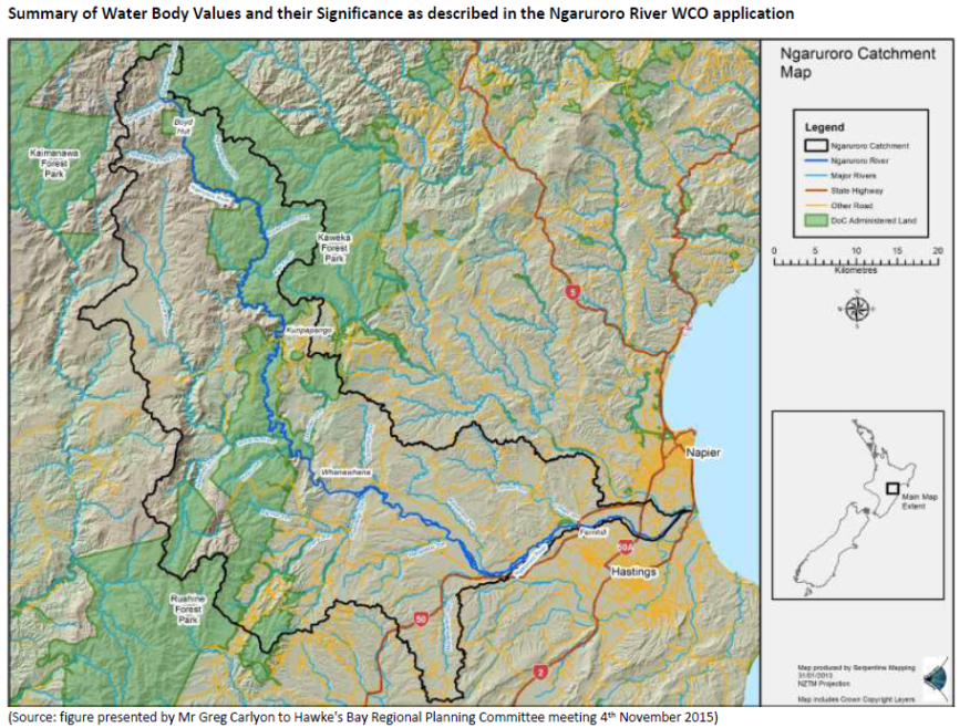
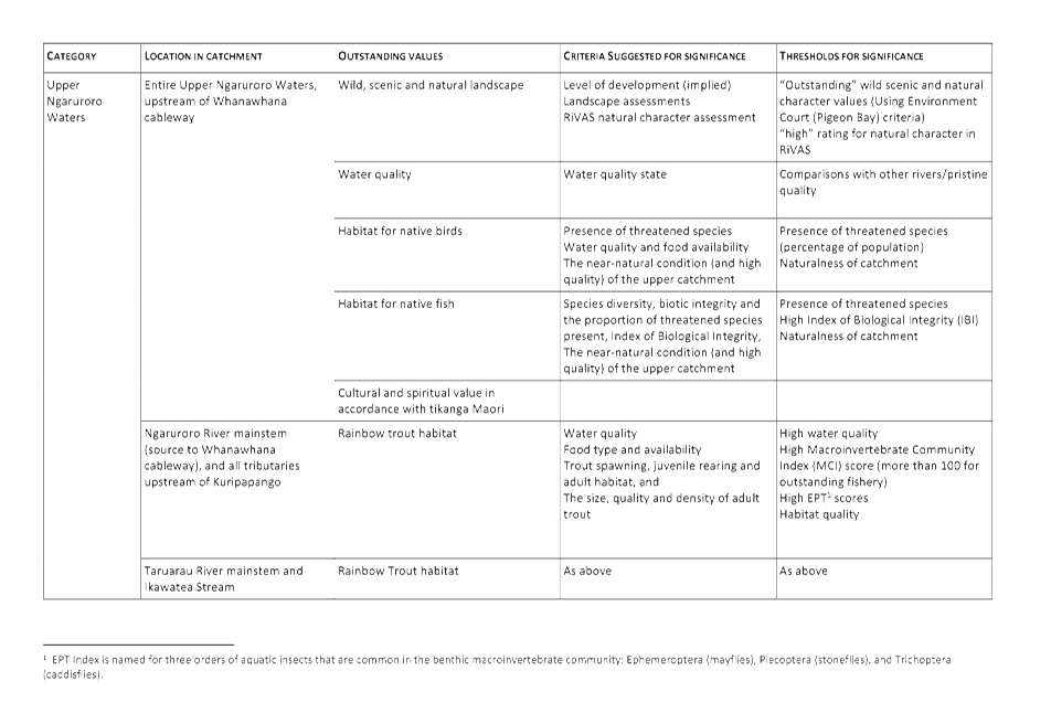
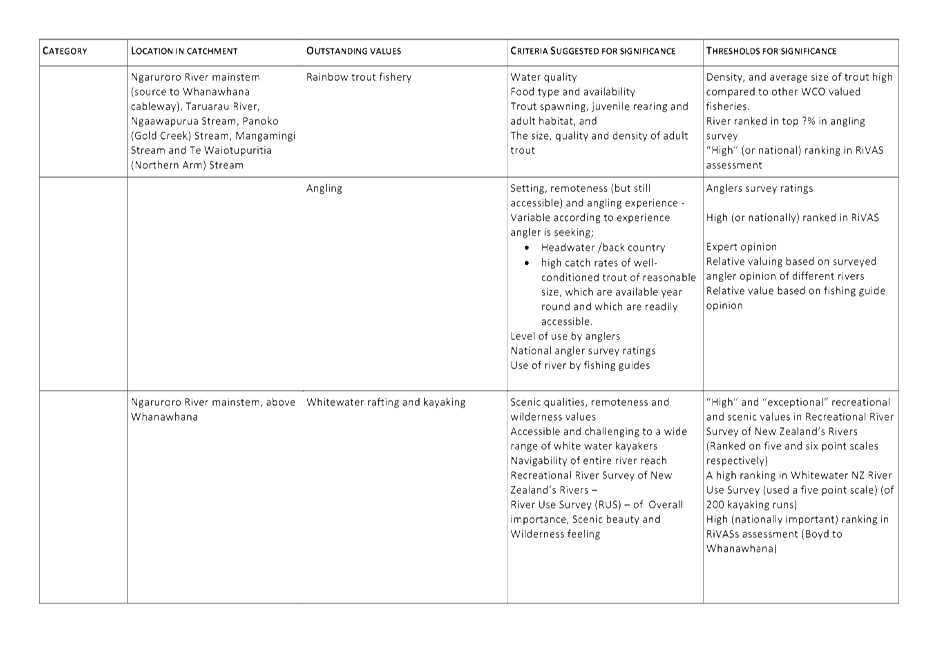
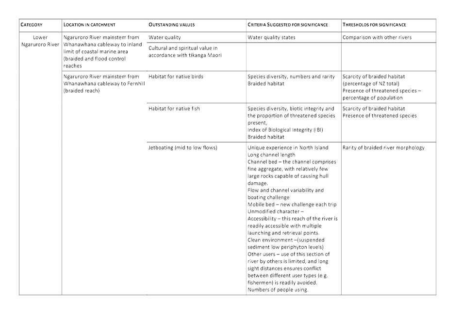
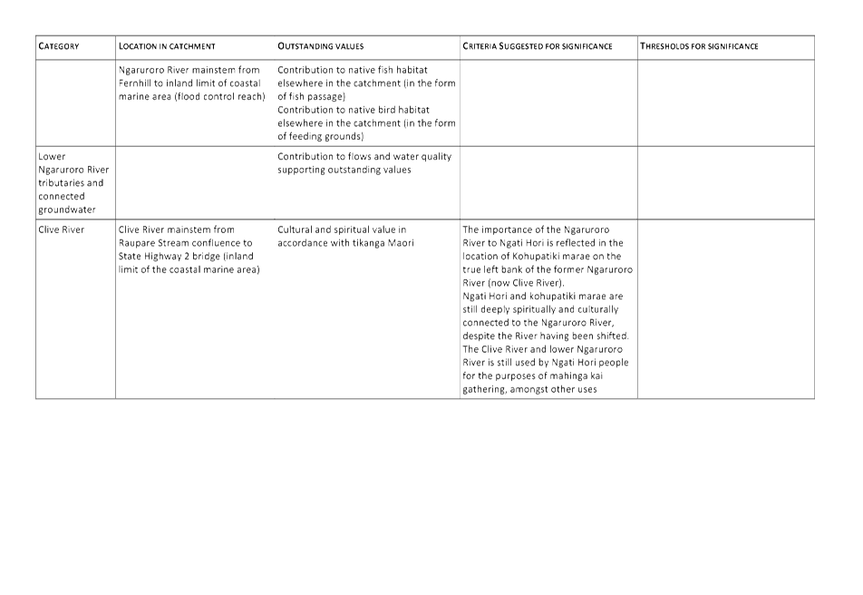
HAWKE’S BAY REGIONAL COUNCIL
Regional
Planning Committee
Wednesday 01 June 2016
SUBJECT: June 2016 Resource Management Planning Project Update
Reason for Report
1. This report provides a brief outline and update of the
Council’s various resource management projects currently underway.
Discussion
2. The projects covered in this report are those involving reviews
and/or changes under the Resource Management Act to one or more of the
following planning documents:
2.1. the Hawke's Bay Regional Resource Management Plan (RRMP)
2.2. the Hawke's Bay Regional Policy Statement (RPS) which is
incorporated into the RRMP
2.3. the Hawke's Bay Regional Coastal Environment Plan (RCEP).
3. This report does not cover the variety of other strategies and
planning projects also underway.
4. From time to time, separate reports additional to this one may be
presented to the Committee for fuller updates on specific plan change projects.
5. The table in Attachment 1 repeats the relevant parts of the resource
management planning work programme from the 2015-25 Long Term Plan.
6. Similar periodical reporting will also be presented to the Council
as part of the quarterly reporting and end of year Annual Plan reporting
requirements.
Decision Making
Process
7. Council is required to make a decision in accordance with Part 6
Sub-Part 1, of the Local Government Act 2002 (the Act). Staff have
assessed the requirements contained within this section of the Act in relation
to this item and have concluded that, as this report is for information only
and no decision is to be made, the decision making provisions of the Local
Government Act 2002 do not apply.
|
Recommendation
That the Regional Planning Committee
receives and takes note of the ‘June 2016 Resource Management
Planning Projects Update’ report.
|
|
Gavin Ide
Manager, Strategy and Policy
|
James Palmer
Group Manager
Strategic Development
|
Attachment/s
|
1
|
Status Report
on HBRC Resource Management Plan Change Preparation & Review Projects as
at 25 May 2016
|
|
|
|
Status
Report on HBRC Resource Management Plan Change Preparation & Review
Projects as at 25 May 2016
|
Attachment 1
|
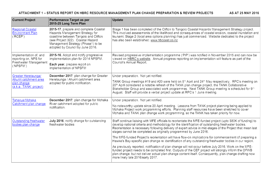
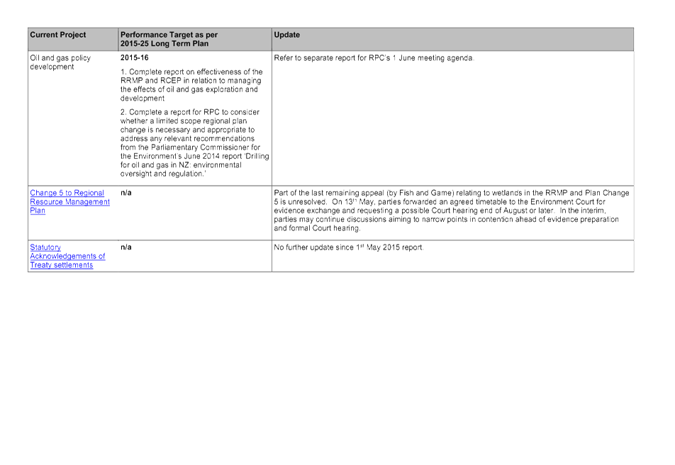
HAWKE’S BAY REGIONAL COUNCIL
Regional
Planning Committee
Wednesday 01 June 2016
SUBJECT: March 2016 - May 2016 Statutory
Advocacy Update
Reason for Report
1. This paper reports on proposals forwarded to the Regional Council
and assessed by staff acting under delegated authority as part of the
Council’s Statutory Advocacy project between March 2015 and May 2016.
2. The Statutory Advocacy project centres on resource
management-related proposals upon which the Regional Council has an opportunity
to make comments or to lodge a submission. These include, but are not
limited to:
2.1. resource consent applications publicly notified by a territorial
authority
2.2. district plan reviews or district plan changes released by a
territorial authority
2.3. private plan change requests publicly notified by a territorial
authority
2.4. notices of requirements for designations in district plans
2.5. non-statutory strategies, structure plans, registrations, etc
prepared by territorial authorities, government ministries or other agencies
involved in resource management.
3. In all cases, the Regional Council is not the
decision-maker, applicant nor proponent. In the Statutory Advocacy
project, the Regional Council is purely an agency with an opportunity to make
comments or lodge submissions on others’ proposals. The Council’s
position in relation to such proposals is informed by the Council’s own
Plans, Policies and Strategies, plus its land ownership or asset management
interests.
4. The summary plus accompanying map outlines those proposals that the
Council’s Statutory Advocacy project is currently actively engaged in.
Decision Making Process
5. Council is required to make every decision in accordance with Part 6
Sub-Part 1, of the Local Government Act 2002 (the Act). Staff have
assessed the requirements in relation to this item and have concluded that, as
this report is for information only and no decision is to be made, the decision
making provisions of the Local Government Act 2002 do not apply.
|
Recommendation
1. That the Regional Planning Committee
receives the March 2015 – May 2016 Statutory
Advocacy Update report.
|
|
James Palmer
Group Manager
Strategic Development
|
|
Attachment/s
|
1
|
Statutory Advocacy Map
|
|
|
|
2
|
Stautory Advocacy Update
|
|
|
|
Statutory
Advocacy Map
|
Attachment 1
|

|
Stautory Advocacy Update
|
Attachment 2
|
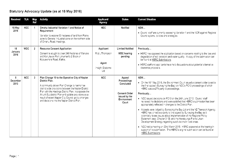
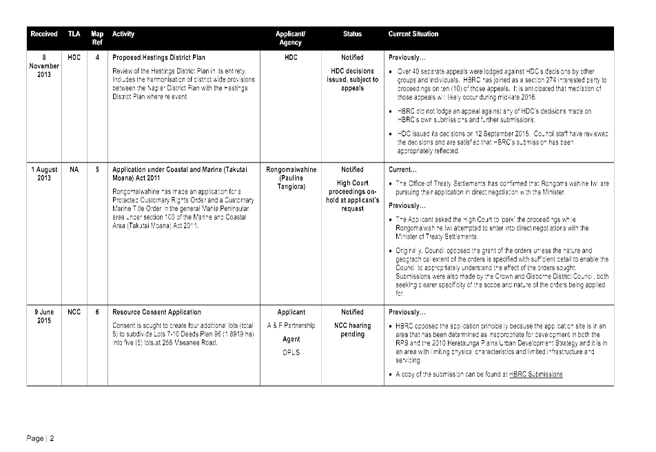
HAWKE’S BAY REGIONAL COUNCIL
Regional
Planning Committee
Wednesday 01 June 2016
SUBJECT: Minor Items Not on the Agenda
Reason for Report
This document has been
prepared to assist Councillors note the Minor Items Not on the Agenda to be
discussed as determined earlier in Agenda Item 6.
|
Item
|
Topic
|
Councillor
/ Staff
|
|
1.
|
|
|
|
2.
|
|
|
|
3.
|
|
|
|
4.
|
|
|
|
5.
|
|
|