Meeting of the Regional Planning Committee
Date: Wednesday 16 September 2015
Time: 9.30am – Tangata Whenua Representatives Hui
10.45am – morning tea
11.00am – Public Committee meeting commences
12.30pm – Lunch
1.00pm – Public Committee meeting recommences
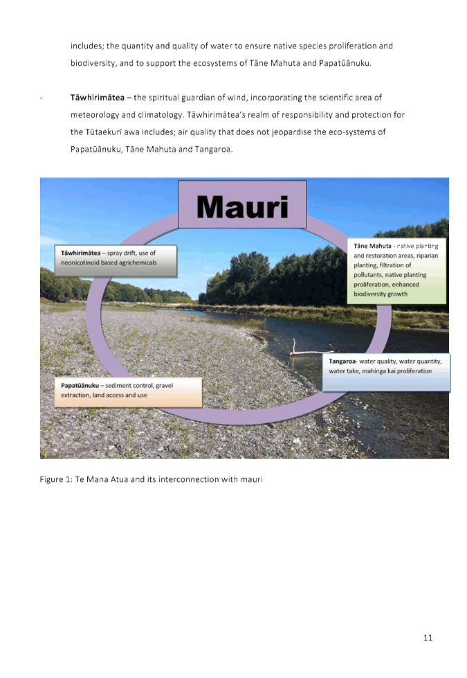
|
Venue:
|
Council Chamber
Hawke's Bay Regional Council
159 Dalton Street
NAPIER
|
Agenda
Item Subject Page
1. Welcome/Notices/Apologies
2. Conflict of
Interest Declarations
3. Confirmation of
Minutes of the Regional Planning Committee held on Wednesday 20 May
4. Matters Arising
from Minutes of the Regional Planning Committee held on Wednesday 20 May
5. Follow-up Items
from Previous Regional Planning Committee Meetings 3
6. Call for any Minor
Items Not on the Agenda 7
Decision Items
7. Regional Planning
Committee Annual Activity Report 2014-15 9
8. Verbal Nga
Hapu o Tutaekuri Hapu Management Plan – 1:30pm
Te Kaha/Hinewai 27
9. Clean Air
Compliance Strategy 73
10. Petroleum Exploration Proposed
Block Offer 2016 81
Information or Performance Monitoring
11. Verbal Ngaruroro Water
Conservation Order Proposal – 1:00pm Greg
Carlyon 93
12. Forestry Policy Issues 95
13. September 2015 Resource
Management Planning Project Update 103
14. Verbal Matatini 2017 - 3:00pm
- Narelle Huata
15. May-September 2015 Statutory
Advocacy Update 107
16. Minor Items Not on the Agenda 113
Please note – Pre Meeting for Tangata
whenua members of the committee begins at 9:30am
1.
Two hour on-road parking
is available in Vautier Street at the rear of the HBRC Building
2.
The public park in
Vautier Street costs $4 for all day parking. This cost will be reimbursed by
Council.
3.
There are limited
parking spaces (3) for visitors in the HBRC car park – entry of Vautier
Street – it would be appropriate that the “visitors” parks be
available for the members travelling distances from Waiora and CHB
NB:
Any carparks that have yellow markings should NOT be used to park in.
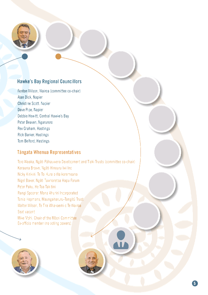
Regional Planning Committee Members
|
Name
|
Represents
|
|
Karauna Brown
|
Ngati Hineuru Iwi Inc
|
|
Nicky Kirikiri
|
Te Toi Kura o Waikaremoana
|
|
Nigel Baker
|
Ngati Tuwharetoa Hapu Forum
|
|
Peter Paku
|
He Toa Takitini
|
|
Rangi Spooner
|
Mana Ahuriri Incorporated
|
|
Tania Hopmans
|
Maungaharuru-Tangitu Trust
|
|
Toro Waaka (co-chair)
|
Ngati Pahauwera Development and Tiaki
Trusts
|
|
Walter Wilson
|
Te Tira Whakaemi o Te Wairoa
|
|
Alan Dick
|
Hawkes Bay Regional Council
|
|
Christine Scott
|
Hawkes Bay Regional Council
|
|
Dave Pipe
|
Hawkes Bay Regional Council
|
|
Debbie Hewitt
|
Hawkes Bay Regional Council
|
|
Fenton Wilson (co-chair)
|
Hawkes Bay Regional Council
|
|
Peter Beaven
|
Hawkes Bay Regional Council
|
|
Rex Graham
|
Hawkes Bay Regional Council
|
|
Rick Barker
|
Hawkes Bay Regional Council
|
|
Tom Belford
|
Hawkes Bay Regional Council
|
Total number of members = 17
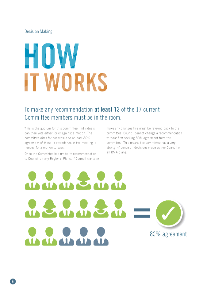
QUORUM AND VOTING ENTITLEMENTS UNDER THE
CURRENT TERMS OF REFERENCE
Quorum (clause (i))
The Quorum for the Regional Planning
Committee is 75% of the members of the Committee
At the present time, the quorum is 13
members.
Voting Entitlement ( clause (j))
Best endeavours will be made to achieve
decisions on a consensus basis, or failing consensus, the agreement of 80% of
the Committee members in attendance will be required. Where voting is
required all membes of the Committee have full speaking rights and voting
entitlements.
Number of Committee members present Number
required for 80% support
17 14
16 13
15 12 14 11 13 10
HAWKE’S BAY REGIONAL COUNCIL
Regional
Planning Committee
Wednesday 16 September 2015
Subject: Follow-up Items from
Previous Regional Planning Committee Meetings
Reason for Report
1. On the list attached as Attachment 1 are
items raised at previous Regional Planning Committee meetings that require
actions or follow-ups.
2. All items indicate which RPC agenda item it
relates to, who is responsible for the follow-up, and a brief status comment.
Once the items have been completed and/or reported to the Committee they will
be removed from the list.
Decision Making Process
3. Council is required to make a decision in
accordance with Part 6 Sub-Part 1, of the Local Government Act 2002 (the Act).
Staff have assessed the requirements contained within this section of the Act
in relation to this item and have concluded that as this report is for
information only and no decision is required in terms of the Local Government
Act’s provisions, the decision making procedures set out in the Act do
not apply.
|
Recommendation
1. That the Regional Planning Committee receives
the report “Follow-up Items from Previous Regional Planning Committee
Meetings”.
|
|
Gavin Ide
Manager, Strategy and Policy
|
Liz Lambert
Chief Executive
|
Attachment/s
|
1
|
Follow-ups
from Previous Meetings
|
|
|
|
Follow-ups
from Previous Meetings
|
Attachment 1
|
Follow-ups
from previous Regional Planning Committee Meetings
Meeting cancelled 15 July
|
|
Agenda Item
|
Action
|
Person Responsible
|
Status Comment
|
|
1. 4
|
Hawke's
Bay Biodiversity Strategy
|
Nil – Meeting cancelled.
|
I Maxwell
|
Hawke's
Bay Regional Biodiversity Strategy presented to Council meeting 29 July and
endorsed at that meeting
|
|
2. 5
|
NPS
for Freshwater Management – 2014-15 Progressive Implementation Report
|
Nil – Meeting cancelled.
|
G Ide
|
Email
sent 28 July to RPC members inviting feedback on draft NPSFM Implementation
Annual Report. Draft report has since been presented to Council meeting
on 26 August.
|
|
3. 6
|
Regional
Planning Committee Annual Activity Report 2014-15
|
Nil – Meeting cancelled.
|
G Ide
|
Email
sent 28 July to RPC members inviting feedback on draft Annual Activity
report. Report publishing on hold pending supply of photos/photography
of members. See separate item on RPC agenda for 16 Sept meeting.
|
|
4. 7
|
Proposed
National Environmental Standard for Plantation Forestry
|
Nil – Meeting cancelled.
|
G Ide
|
Email
sent 28 July to RPC members inviting feedback on draft comments. Staff
presented report to Council meeting on 29 July. HBRC’s submission
was lodged on 11 August.
Also refer to separate item on RPC agenda for 16 Sept meeting.
|
|
5. 8
|
Notice
of Motion from Councillor Peter Beaven
|
Nil – Meeting cancelled.
|
L Lambert
|
Councillor
Beaven’s Notice of Motion was considered at 29 July Council meeting and
further reporting by staff presented at Council meeting on 26 August
|
|
6. 9
|
Ngaruroro
water Conservation Oder Proposal
|
Nil – Meeting cancelled.
|
I Maxwell
|
Presentation
re-scheduled to 16 September 2015 RPC meeting.
|
|
7. 10
|
Karamu
Oxygen Report
|
Nil – Meeting cancelled.
|
I Maxwell
|
Karamu
Catchment - In-stream Flows for Oxygen technical report was approved at 29 July
Council meeting for publication and public release.
|
|
8. 11
|
‘Pataka’
hapu / iwi records tool
|
Nil – Meeting cancelled.
|
G Ide
|
‘Pataka’
online mapping and information storehouse was launched early August.
|
|
9. 12
|
July
Resource Management Planning Project update
|
Nil – Meeting cancelled.
|
G Ide
|
Refer
revised update separate on RPC Agenda meeting 16 September 2015.
|
Meeting held 20 May 2015, plus cancelled
15 July meeting
|
|
Agenda Item
|
Action
|
Person Responsible
|
Status Comment
|
|
10
|
Regional
Planning Committee - Terms of Reference
|
Hui
to be held to seek agreement to the amended Terms of Reference
|
L Lambert
|
|
|
11
|
Water
Quantity Allocation Policy and Consenting Processes
|
Workshop
for RPC members to be held
|
L Lambert/
I Maxwell
|
|
|
12
|
State
of Our Environment Five-Yearly Summary Report
|
Not considered due to loss of quorum
|
I Maxwell
|
Hard
copies of the report distributed with the September RPC agenda
|
HAWKE’S BAY REGIONAL COUNCIL
Regional
Planning Committee
Wednesday 16 September 2015
SUBJECT: Call for any Minor Items Not on the Agenda
Reason for Report
1. Under standing orders, SO 3.7.6:
“Where an item is not on the agenda
for a meeting,
(a) That
item may be discussed at that meeting if:
(i) that
item is a minor matter relating to the general business of the local authority;
and
(ii) the
presiding member explains at the beginning of the meeting, at a time when it is
open to the public, that the item will be discussed at the meeting; but
(b) No
resolution, decision, or recommendation may be made in respect of that item
except to refer that item to a subsequent meeting of the local authority for
further discussion.”
2. The Chairman will request any items committee members wish to be
added for discussion at today’s meeting and these will be duly noted, if
accepted by the Chairman, for discussion as Agenda Item 16.
|
Recommendations
That Regional
Planning Committee accepts the following minor items not on the agenda, for
discussion as item 16:
1.
|
|
Liz Lambert
Chief Executive
|
|
HAWKE’S BAY REGIONAL COUNCIL
Regional
Planning CommitteE
Wednesday 16 September 2015
SUBJECT: Regional Planning Committee Annual Activity Report 2014-15
Reason for Report
1. The attached Draft Report “Regional Planning Committee –
Annual Report for the 1 July 2014 – 30 June 2015 period” provides
an overview of the form and function of the Regional Planning Committee and
reports on its activities over the period 1 July 2014 to 30 June 2015.
2. This version incorporates previous feedback from Committee members
and is virtually ready for publication and printing, pending the inclusion of
members’ photographs.
Decision Making
Process
3. Council is required to make a decision in accordance with the
requirements of the Local Government Act 2002 (the Act). Staff have assessed
the requirements contained in Part 6 Sub Part 1 of the Act in relation to this
item and have concluded the following:
3.1. The decision
does not significantly alter the service provision or affect a strategic asset.
3.2. The use of the
special consultative procedure is not prescribed by legislation.
3.3. The decision
does not fall within the definition of Council’s policy on significance.
3.4. Given the
nature and significance of the issue to be considered and decided, and also the
persons likely to be affected by, or have an interest in the decisions made,
Council can exercise its discretion and make a decision without consulting
directly with the community or others having an interest in the decision.
|
Recommendations
1. That the Regional Planning Committee receives the draft
“Regional Planning Committee Annual Report for 1 July 2014 – 30
June 2015” and instructs staff to proceed with the publication and
distribution of the finalised report as amended as agreed.
|
|
Esther-Amy Powell
Planner
|
Gavin Ide
Manager, Strategy and Policy
|
|
Liz Lambert
Chief Executive
|
|
Attachment/s
|
1
|
Annual
Activity Report 2014-15
|
|
|
|
Annual
Activity Report 2014-15
|
Attachment 1
|


HAWKE’S BAY REGIONAL COUNCIL
Regional
Planning Committee
Wednesday 16 September 2015
Subject: Nga Hapu o Tutaekuri Hapu
Management Plan
Reason for Report
1. The
purpose of this paper is to introduce the report ‘Tutaekuri Awa
Management and Enhancement Plan” - an
iwi/hapu management plan prepared by Nga Hapu o Tutaekuri (Attachment 1).
2. Nga
Hapu o Tutaekuri is mandated by Waiohiki Marae, Moteo Marae, Wharerangi Marae
and Timikara Marae for the development of the iwi/hapu management plan. Representatives
from Nga Hapu o Tutaekuri will be giving a presentation on Tutaekuri Awa
Management and Enhancement Plan at the meeting.
Relevance of this Iwi
Management Plan
3. This iwi/hapu
management plan has been approved by Ngati Kahungunu Iwi Incorporated as an iwi
authority under the RMA and it therefore has status under the Resource
Management Act.
4. As part of the
plan change process for the Greater Heretaunga / Ahuriri catchments (aka the
‘TANK plan change’), the Regional Planning Committee must
‘take into account’ iwi management plans that have been approved by
an iwi authority and lodged with the Regional Council.
5. How iwi/hapu
management plans are ‘taken into account’ will be demonstrated
through various planning reports that will be presented to the Committee as
part of future RMA-related policy development processes.
6. Previously in
relation to presentations being delivered to the Committee by representatives
of earlier iwi/hapu management plans, the Committee has chosen to recommend
Council “acknowledges the role” of IHMPs in relevant resource
management policy and plan change processes, over and above just
‘receiving’ the IHMP.
Decision Making
Process
7. Council is required to make a decision in accordance with the
requirements of the Local Government Act 2002 (the Act). Staff have
assessed the requirements contained in Part 6 Sub Part 1 of the Act in relation
to this item and have concluded the following:
7.1. The decision does not significantly alter the service provision or
affect a strategic asset.
7.2. The use of the special consultative procedure is not prescribed by
legislation.
7.3. The decision does not fall within the definition of Council’s
policy on significance.
7.4. The persons
affected by this decision are members of Nga Hapu o Tutaekuri.
7.5. There are no
alternative options. Once an iwi/hapu management plan is approved by an iwi
authority and lodged with Council, the plan must be taken into account in
relevant RMA-related policy development initiatives. There is no option
to ‘reject’ a hapu/iwi management plan that has been approved by an
iwi authority and then lodged with the council.
7.6. The decision is not inconsistent with an existing policy or plan.
7.7. Given the nature and significance of the issue to be considered and
decided, and also the persons likely to be affected by, or have an interest in
the decisions made, Council can exercise its discretion and make a decision
without consulting directly with the community or others having an
interest in the decision.
|
Recommendations
1. That the Regional Planning Committee receives the presentation on Tutaekuri Awa
Management and Enhancement Plan by representatives of Nga Hapu o Tutaekuri.
2. The Regional Planning Committee recommends that Council:
2.1. Agrees that the decisions to be made are not significant under the
criteria contained in Council’s adopted policy on significance and that
Council can exercise its discretion under Sections 79(1)(a) and 82(3) of the
Local Government Act 2002 and make decisions on this issue without conferring
directly with the community and persons likely to be affected by or to have
an interest in the decision due to the nature and
significance of the issue to be considered and decided.
2.2. Acknowledges the role of Tutaekuri Awa Management and Enhancement
Plan in the Greater Heretaunga / Ahuriri policy development process under the
Resource Management Act.
|
|
Esther-Amy Powell
Planner
|
Gavin Ide
Manager, Strategy and Policy
|
|
Liz Lambert
Chief Executive
|
|
Attachment/s
|
Management
Plan
|
Attachment 1
|


HAWKE’S BAY REGIONAL COUNCIL
Regional
Planning Committee
Wednesday 16 September 2015
Subject: Clean Air Compliance
Strategy
Reason for Report
1. This report is
to inform on the current position for the HBRC Heatsmart programme in terms of
effectiveness in meeting NES targets, and to propose a strategy that encourages
compliance with the air plan rules.
Background
2. HBRC aims to
improve air quality and meet the National Air Quality Standards. In this report
you will read the terms PM10, NES and airsheds.
3. PM10 is made up
of solid or liquid particles less than 10 micrometres in diameter, roughly a
fifth of the width of a human hair. PM10 cannot be seen by eye, can remain
suspended in air for long periods and is easily inhaled. In 2010 92 -95% of
PM10 emissions in urban centres came from domestic fires. The ability to
readily inhale PM10 means that it can contribute to respiratory diseases and it
has also been associated with cardiovascular problems. Those at most risk are
the elderly, young children and people with existing respiratory and
cardiovascular diseases. The smaller the particle, the further it can penetrate
into the airways and lungs and the ultra-fine particles, less than 0.1
micrometres, may enter the blood stream. There is no known “safe”
threshold for PM10 so the NES is designed to provide a set level of protection
for human health and the environment.
4. The Government
set a National Environmental Standard (NES) for PM10 in 2005 at an average
concentration of no more than 50mg/m3 measured in open air over a 24hour
period. Only one exceedance of this level is allowed in an airshed in a twelve
month period.
5. Airsheds are
air quality management areas designated by Regional Councils and they are
typically where levels of pollutants are known to, or likely to exceed NES. The
Napier airshed has to achieve compliance with no more than one exceedance per
year by 2016, and Hastings one exceedance by 2020 with an interim target of 3
exceedances by 2016, i.e. next year. The first phase out date banned the use of
inefficient open fires in 2012, and in 2014 burners installed before
1996. The next target is January 2016 where burners from 1996-2005 have
to be replaced or not used.
6. Since 2009 HBRC
has monitored air quality and has had a funding package in place to assist and
incentivise home owners and landlords to install insulation and clean forms of
heating (i.e. heatpump/aircon or compliant burners).
7. HBRC has now
achieved over half the projected volume targets for the Heatsmart
incentive/grants programme and seen a corresponding drop in NESAQ exceedances
in the cities. It is now timely to review some key issues.
Will we meet the NES target?
8. Original
estimates suggested that 10,000 fires would have to be replaced in order to
meet NES targets assuming that at least 40% would be replaced with fires rather
than heatpumps. The programme was anticipated to run for ten years, with an
average 1000 fires per annum. We are just over half way to meeting target
volumes for converting non-compliant fires. The following table shows that HBRC
has supported the replacement of 6932 fires to date with increased activity in
the phase out years.
|
Details
|
2009-10
|
2010-11
|
2011-12
|
2012-13
|
2013-14
|
2014-15
|
Total
|
$
|
|
Insulation Loans
|
150
|
221
|
471
|
809
|
372
|
128
|
2,151
|
4,122,582
|
|
Clean Heat Loans
|
97
|
143
|
297
|
439
|
801
|
548
|
2,325
|
7,076,442
|
|
Clean Heat Grants
|
52
|
124
|
442
|
1,074
|
1,689
|
1,226
|
4,607
|
2,844,011
|
|
TOTAL
|
299
|
488
|
1,210
|
2,322
|
2,862
|
1,902
|
9,083
|
14,043,035
|
9. In the year
2014 – 2015 we met 2020 NES target for the first time, five years early.
While this shows we are heading in the right direction and making good progress
it doesn’t mean we have solved the problem. Its only one year, and we
need five consecutive years of meeting the targets under the current
legislation to deregulate the areas, and then we are still required to continue
monitoring.
10. The NES level of 50mg only
breached once this winter in Hastings on 9th June but came close on
several occasions in both Napier and Hastings. On eight additional days
Hastings scored over 40 mg, and in Napier there were 11 days between 30 -50
mg. Other drivers beyond our control may result in an increase in
exceedances. For example a high pressure weather system staying in place with
low wind for more than three low temperature days would have a significant
impact causing one or more exceedances in a relatively short period of time.
11. The other major influences
on emissions are how and what people burn, whether or not they have a compliant
fire. This requires ongoing education, behaviour change strategies and
regulation under local bylaws for nuisance burning.
12. Survey information and an
emissions inventories sourced in 2010 and 2015 suggests that we will meet the
targets as currently specified.
Fig. 1 -
shows how the amount of PM10 has decreased by 50% between 2010 and 2015 in
Napier and the proportional sources of PM10
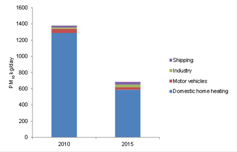
Fig. 2 -
shows how Napier is tracking toward NES targets 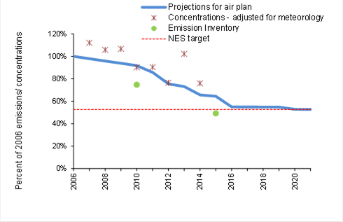
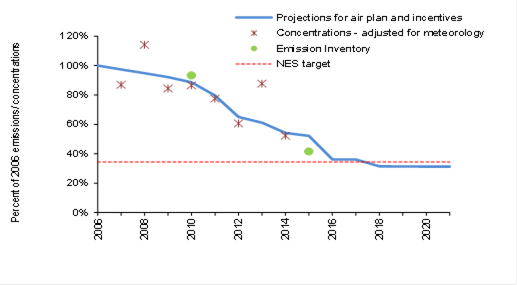
Fig. 3
- shows how the amount of PM10 has decreased by 56% between 2010 and 2015 in
Hastings and the proportional sources of PM10 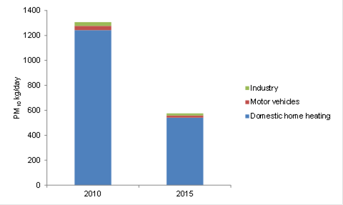
Fig. 2 -
shows how Hastings is tracking toward NES targets
13. In the five years between
2005 and 2015 there has been a significant gain over the target projections for
the air plan and the Heatsmart programme. If the current conversion rate of
non-compliant fires continues, combined with a burning behaviour change
programme, targets can be achieved.
Where is public perception on this matter?
14. Since 2010 there has been
a positive shift from ‘why’ to ‘when’ as we have moved
through the first two phase out dates. The next major phase out date in January
2016 when non-compliant fires installed from 1996 to 2005 (when the legislation
was introduced) become prohibited from use. We have no idea how many of these
there are as records of installation prior to 2005 are unreliable and fires
replaced with heatpumps do not require permits. It is also likely that a number
of these older fires have already been replaced prior to the phase out date due
to our ‘point of sale’ rule that brings forward the non-compliance
date.
Public perceptions that need to be
addressed
15. “I don’t
need to do anything now, we’ve met the targets.”
15.1. Self-congratulation in
the media for meeting the target this year could encourage complacency at best,
and further resistance at worst. Meeting the target is a ‘good
news’ item but doesn’t address the issues of inequity or
resistance. Its only one year, and we need five consecutive years of meeting
the targets under the current legislation to deregulate the areas, and then we
are still required to continue monitoring.
16. “No one has been
fined, or is likely to be. HBRC won’t know if I use a non-compliant
fire.”
16.1. Nobody has yet been
fined locally or nationally for use of domestic non-compliant fires and it may
be hard to reconcile the first fine being in the year that there were zero
exceedances in Napier. There have been 420 smoke complaints to Council since
the air plan was enacted. Initial response to complaints was aimed towards
education but in the past 9 months Council has issued 4 infringement fines and
1 abatement notice in response to complaints about outdoor burning.
17. “I don’t
have a smokey chimney, it’s all the others in my street and you’re
not doing anything about it and ……these new fires aren’t as
good as the old ones”
17.1. Just replacing a fire
(unless with a zero emission heatpump or a gas fire) does not address the
‘what and the how’ of burning. Research carried out as part of a
project sponsored by MFE shows that people think they aren’t the problem
and don’t know how much smoke their fire is generating because they
don’t go outside and check. There is a gap between perception and reality
where education and training on fire management could have a significant impact
on emission levels. HBRC is on the governance group for this project and is
working with Environment Canterbury and five other regional councils to develop
a behaviour change programme to be used nationally.
18. HBRC has a communication
plan in place for 2015 and is planning for the phase out planned in January
2016. The marketing and communications programme will continue to promote
HBRC’s package of Heatsmart loans and grants, and education material. In
late 2015 we will inform people about the 1996-2005 burners need for
replacement and reinforce key messages to those who have not yet replaced
non-compliant burners.
19. Key target areas are
Taradale, Tamatea, Maraenui, Napier South and Raureka, Mayfair and Flaxmere.
Key Public Messages
20. Hawke’s Bay halfway
through the programme, we are halfway to meeting targets and getting cleaner
winter air as planned.
21. HBRC can still help with
your smokey burner – loans, grants, replacement advice.
22. HBRC charges you a rate
for cleaning the air – have you claimed what you’ve paid for?
23. Lower interest rates on
loans now available from HBRC =3%
24. Beat the rush –
busiest time for installers is April/May. Act now to get in for winter as
there is up to a 6 weeks wait.
25. To really improve smoke
emissions install heat pumps.
26. Burn dry wood only.
27. January 2016 - next phase
out date for burners installed 1996-2005. Anything installed after the
clean air legislation came in in 2005 is likely to be compliant.
What do we do about inequity and/or
resistance?
28. It is reasonable to assume
that the population is divided into three main groups, those who will, those
who might, and those who won’t adopt change.
29. The Heatsmart programme
has to date focused on encouragement, providing financial incentives,
education, and promoting of the benefits associated with better air quality.
HBRC has primarily targeted increasing affordability for ‘those who
will’ and ‘those who might’ to maximize our return on
investment. While all ratepayers within the airsheds pay an annual targeted
rate to fund the programme, there is a concern regarding inequity between those
who have changed and those who are resistant, where the cost of change is being
born by those who have met the expense of installing clean heat.
30. As the programme moves
into the second half, the issue of regulation and compliance is going to become
more important as the number of those remaining will come from the group that
are most resistant to change.
31. Enforcement of the air
rules as they relate to non-compliant domestic fires is problematic in that
there is no legal power of entry for officers to enter into dwelling houses to
physically check on compliance. I.e. to physically view and check whether or
not the installed fire is compliant or actually being used.
32. This restriction is
contained in section 332[1] of the Resource Management Act that allows
enforcement officers to enter onto land under certain circumstances, but
expressly prohibits entry into a dwelling house. That also precludes an
enforcement officer from standing outside the dwelling and looking through a
window or door to assess compliance.
33. While there have been
limited reports from the public of people using non-compliant fires, those
reports have been followed up by compliance staff. The current manner of follow
up is to provide educational material to those involved in an attempt to get
them to upgrade their current fireplace and/or take advantage of the Council
loans and grants available for that purpose. No data has been collected to
measure the success of that approach or otherwise.
34. There have been 420 smoke
complaints to Council since the air plan was enacted. Initial response to
complaints was heavily leaned towards education but in the past 9 months
Council has issued 4 infringement fines and 1 abatement notice in response to
complaints related to outdoor burning. There is every indication that education
has had a positive effect.
35. Under the current rule
regime, there is scope to become more active in the enforcement space and the
value of doing that needs to be assessed closely.
36. Without any rule change,
it is possible to investigate complaints by observing if excessive smoke is
being discharged from a suspected property chimney or flue. There is an ability
to check installer records to ascertain if a compliant fire has been installed,
Council has access to those records. Should it appear on reasonable grounds
[excess smoke and no record of a compliant burner being fitted] that the
property owner is operating a non-compliant fire, an abatement notice may be
issued requiring them to either cease the use of that fire or replace it with a
complying fire.
37. Our understanding is that
this strategy has had some success in Canterbury and Nelson, where there has
been no need to take any further enforcement action beyond abatement. In all
probability the same level of success would operate in Hawke’s Bay but
there is still a minimal risk that the installer information might be wrong or
that the property owner fails to comply with the abatement notice and this
Council must decide on whether to take further enforcement action or not. This
year Environment Canterbury introduced a new compliance tool to their air plan
which could be of significant benefit if adopted in Hawke’s Bay. All
fires produce smoke at start up and when re-fuelled (20mins on start-up and
5mins on re-fuel) however, efficient burning produces very little particulate
matter and an education programme linked to a ‘No visible smoke’
rule is proving effective in reducing emissions beyond that achieved by
replacing non-compliant fires.
38. The major benefit of the
‘No visible smoke’ rule is that it provides a unambiguous measure
for regulatory purposes, it avoids the problem of not being able to enter the
property and would encourage public engagement in enforcing bylaw 13 by the
Napier and Hastings councils which states:
38.1. “No occupier of
any private residential premises shall permit smoke, noxious fumes or other
matter to be emitted from any chimney, fireplace, barbecue, incinerator or
other device on such premises to such an extent as to cause a nuisance, to
persons residing or being in the neighbourhood. Where in the opinion of a duly
authorised officer of Council a nuisance is being caused, the officer may
require the nuisance to be abated to his or her satisfaction immediately”
39. Amending our Air Plan
rules to include a ‘No visible smoke’ clause would require planning
time and resources that are currently fully committed. It should be noted that
the Minister for the Environment has also signalled a review of national
emission standards that may involve a move to PM2.5 rather than PM10 and a
consequent adjustment in targets that would require an Air Plan Change, which
could then include a ‘no visible smoke’ clause.
40. It is recommended that
staff evaluate the Environment Canterbury initiative for possible future
implementation in Hawke’s Bay.
41. In determining whether or
not this strategy is appropriate, some issues should be taken into account:
41.1. Any increased
enforcement of the rules are likely to raise community awareness
41.2. Is this level of
enforcement justified yet?
41.3. If no action is taken
against persons complained of, what message does this send to others in the
community who have taken active steps to comply with the rules?
41.4. Is there likely to be a
negative public reaction to whichever strategy Council follows?
Regulatory response
42. All complaint calls are responded
to with an on-site inspection.
43. If there is no evidence to
support the complaint the occupier is notified of the complaint, information is
offered but no enforcement action is taken.
44. If there is evidence,
depending on severity, an abatement notice may be issued and instruction given
to cease or replace as appropriate to a reasonable timeframe. If not,
information and advice given. Any future report or inspection that is a
repetition following an abatement could be liable for infringement fine at the
discretion of the inspecting officer.
45. Share all complaints and
outcomes with relevant territorial authority for action under Bylaw 13.
Proposed non-regulatory interventions
46. January 2016 direct mail
out to all airshed properties that have no record of compliant heating; Inform
of air rules; invite to update our records.
47. Mail drop to areas showing
high PM10 averages stating ‘spotter’ inspections will be carried
out between stated winter dates; Inspection identifies smoke problems; Letter specifying
date observed and corrective action required; Repeat inspection at monthly
intervals.
48. The table below describes
the current actions being taken to encourage compliance and in italics,
new initiatives proposed
|
Proposal
|
Advantage
|
Disadvantage
|
|
Maintain the scheme until target
achieved for five years
|
Meeting current NES target
|
Cost to ratepayers
|
|
Continue with education and new
behavior change initiatives
|
Positive, supportive reputation
|
|
|
Promote dry wood scheme
|
Encourages better burning / less
emissions for those who replace fires with fires
|
|
|
Maintain Pollution hot line for
reporting Nuisance burning (bylaw 13 Napier and Hastings) and continue with
enforcement visits
|
Public visibility on enforcement
response to public requests
|
Danger of HBRC being seen as the
smoke police
|
|
Circulate all home owners in
targeted areas with reminder letter that records show they are likely to have
a non-compliant fire and what action to take
|
Awareness that HBRC
‘knows’ who may be non-compliant
Updated records
|
Cost
Perception of harassment
|
|
Investigate No visible smoke rule
|
Objective observation that can
provide evidence without entering the property
|
Cost of plan change and committed
work programme
|
|
Spotter teams – in house and
outsourced
|
Increased awareness
|
Cost
|
Decision Making
Process
49. Council
is required to make a decision in accordance with the requirements of the Local
Government Act 2002 (the Act). Staff have assessed the requirements
contained in Part 6 Sub Part 1 of the Act in relation to this item and have
concluded the following:
49.1. The decision
does not significantly alter the service provision or affect a strategic asset.
49.2. The use of
the special consultative procedure is not prescribed by legislation.
49.3. The decision
does not fall within the definition of Council’s policy on significance.
49.4. The persons affected by this
decision are ratepayers in Airsheds
49.5. The decision
is not inconsistent with an existing policy or plan.
49.6. Given the
nature and significance of the issue to be considered and decided, and also the
persons likely to be affected by, or have an interest in the decisions made,
Council can exercise its discretion and make a decision without consulting
directly with the community or others having an interest in the
decision.
|
Recommendations
The Regional
Planning Committee recommends that Council:
1. Agrees that the decisions to be made are not significant under the
criteria contained in Council’s adopted policy on significance and that
Council can exercise its discretion under Sections 79(1)(a) and 82(3) of the
Local Government Act 2002 and make decisions on this issue without conferring
directly with the community and persons likely to be affected by or to have
an interest in the decision due to the nature and significance
of the issue to be considered and decided.
2. Notes progress to date in meeting NES targets
3. Approves the proposed actions regarding communication and
enforcement
4. Instructs staff to investigate the efficacy of a ‘no visible
smoke’ rule.
|
|
Mark Heaney
Client Services Manager
|
Wayne Wright
Manager Resource Use
|
|
Iain Maxwell
Group Manager Resource Management
|
|
Attachment/s
There are no
attachments for this report.
HAWKE’S BAY REGIONAL
COUNCIL
Regional
Planning Committee
Wednesday 16 September 2015
SUBJECT: Petroleum Exploration Proposed Block Offer 2016
Reason for Report
1. New Zealand Petroleum and Minerals (NZP&M) has invited the
Hawke's Bay Regional Council and other local authorities to provide comments on
its proposed Block Offer 2016 for petroleum exploration. The deadline for
comments to be lodged is 30 October 2015.
2. Staff have prepared draft comments (see Attachment 2) for the
Committee to consider and amend as necessary before referring on to the Council
for further consideration.
3. It is worth noting that these draft comments are virtually identical
to the Council’s comments made in respect of last year’s 2015 Block
Offer which related to slightly different parts of the offshore Pegasus Basin.
Discussion
4. NZP&M (a branch of the Ministry of Business, Innovation and
Employment) administers the Block Offer 2016 and is seeking the Council’s
comments on specific areas of consultation in and near the Hawke's Bay region
(see location map in Attachment 1).
5. The Block Offer process is a process through which the Government
seeks to attract companies that have a demonstrated ability to prospect,
explore and mine petroleum in a safe and environmentally responsible way.
Exploration won’t necessarily be undertaken in all the blocks on offer.
6. The Block Offer 2016 requires bidders to submit ‘staged work
programme bids’ – where bids are submitted to undertake a work
programme to explore for petroleum resources. The specific exploration
activities[2]
to be undertaken in a permitted area are not determined as part of the
Block Offer process. The Government is consulting on a total 537,632
square kilometres across four proposed offshore areas and one proposed onshore
areas. The areas being consulted on generally exclude any existing permits,
and do not include any World Heritage sites, Marine Reserves or areas listed in
Schedule 4 of the Crown Minerals Act 1991.
7. In relation to the Hawke's Bay region, the proposed area for
consultation is the Offshore Pegasus East Coast basin (68,661 km2) (see
Attachment 1).
8. Much of this proposed offshore area lays beyond the region’s
12 nautical mile limit. Provisions of the Hawke's Bay Regional Coastal
Environment Plan do not apply beyond the 12 nautical mile limit (approximately
22 kilometres offshore).
9. The Minister says feedback from iwi and local authorities ensures
that any areas of sensitivity are carefully considered before the 2016 tender
round is finalised.
10. Staff
have drafted comments on the Block Offer 2016. Those comments are set out in
Attachment 2. It is recommended that the RPC considers and discusses
those draft comments for Council consideration.
11. Following
consultation with iwi/hapu about Block Offer 2016, and feedback from local
authorities, NZP&M will prepare a report for the Minister. The
Minister will then make a final decision on the blocks to be included in the
Block Offer 2016. No further consultation will be undertaken with
iwi/hapu and councils on the Block Offer 2016 and subsequent decisions on the
grant of petroleum exploration permits.
|
Recommendations
1. That the Regional Planning Committee receives the Petroleum Exploration Proposed Block Offer 2016 draft comments
and amend as necessary for referral to the Council.
2. The Regional Planning Committee recommends that Council:
2.1. Agrees that the decisions to be made are not significant under the
criteria contained in Council’s adopted policy on significance and that
Council can exercise its discretion under Sections 79(1)(a) and 82(3) of the
Local Government Act 2002 and make decisions on this issue without conferring
directly with the community and persons likely to be affected by or to have
an interest in the decision due to the nature and
significance of the issue to be considered and decided.
2.2. Lodges the comments on Block Offer 2016, including agreed
amendments, with New Zealand Petroleum and Minerals by the 30 October 2015
deadline.
|
|
Gavin Ide
Manager, Strategy and Policy
|
Liz Lambert
Chief Executive
|
Attachment/s
|
1
|
Location Map
- Proposed Block Offer 2016 Offshore Pegasus East Coast Basin area
|
|
|
|
2
|
DRAFT
Comments on NZ Petroleum and Minerals proposed Block Offer 2016
|
|
|
|
Location
Map - Proposed Block Offer 2016 Offshore Pegasus East Coast Basin area
|
Attachment 1
|

|
DRAFT Comments on NZ
Petroleum and Minerals proposed Block Offer 2016
|
Attachment 2
|
Our Ref: RMP
2-2
xx October 2015
Josh Adams
New Zealand Petroleum and Minerals
Ministry of Business, Innovation and
Employment
PO Box 1473
Wellington 6140
via email to:
blockoffer2016@mbie.govt.nz
Dear Mr Adams
Comments
on Proposed Block Offer 2016
Thank
you for the opportunity to provide comments on the proposed Block Offer 2016
(‘BO2016’).
You
had invited comments on a number of specific matters. Those comments are
provided in section 2. We note that these comments are virtually a
replica of our comments on the Block Offer 2015 because in both 2015 and 2016
Block Offers, the proposed area was the offshore Pegasus East Coast Basin.
These
comments were considered and agreed by the Council at its meeting on [date].
Yours sincerely
liz lambert
Interim Chief
Executive
Phone: (06) 835 9214
Email: liz@hbrc.govt.nz
Address for Service: Hawke's
Bay Regional Council
Private Bag
6006
NAPIER
4142
Attn:
Gavin Ide
e: gavin@hbrc.govt.nz
p:
(06) 833 8077
1. General comments
1.1 Capacity and engagement
In recent years, HBRC has
continued to develop capacity and liaise with other councils and central
government agencies regarding oil and gas exploration activities in Hawke's
Bay. Examples include participation in a public forum event hosted by Hastings
District Council on the topic of oil and gas exploration industry.
Another example is the ongoing liaison at various levels with government
officials and departments, including NZP&M.
Oil and gas exploration has
clearly emerged over recent years as a hot topic in public submissions made on
HBRC’s Long Term Plan and 2014-15 Annual Plan. We are conscious
that the issue of oil and gas exploration is one in which there is significant
public interest, and there is much debate within our community around the
environmental issues and risks associated with these activities. The Oil and
Gas Symposium hosted by Hastings District Council just over two years ago
confirmed the high level of public interest.
HBRC recognises that
significant local and national economic benefits may accrue should oil and gas
production develop commercially in the East Coast Region. We are also
conscious of the potential impact on our broader economy and social environment
and take this opportunity to provide comments on some additional matters.
HBRC’s work programme
adopted in the 2015-25 Long Term Plan indicates HBRC will:
1. develop a Hawke's
Bay Energy Strategy (with a draft strategy adopted by Council by March 2016);
2. complete a report
on the effectiveness of the Regional Resource Management Plan and Regional
Coastal Environment Plan in relation to managing the effects of oil and gas
exploration and development;
3. prepare a
community engagement plan for potential oil and gas exploration and development
in Hawke's Bay;
4. complete a report
for the Regional Planning Committee to consider whether a limited scope
regional plan change is necessary and appropriate to address any relevant
recommendations from the Parliamentary Commissioner for the Environment’s
June 2014 report ‘Drilling for oil and gas in New Zealand: environmental
oversight and regulation.”
1.2
Sensitive areas
HBRC has previously
indicated to NZP&M in relation to earlier Block Offers that we would be
uncomfortable with any offer made across the region’s productive
aquifers. We welcomed the Minister’s decision on the 2014 Block
Offer to exclude the aquifers from the finalised areas.
We note that the BO2016
does not propose any onshore areas, so we do not have to revisit exclusions of
the region’s productive aquifers.
From the maps available
with the BO2016 documentation, it appears that the BO2016 Offshore Pegasus area
barely extends into the Hawke's Bay region, with much of the area lying south
east of the region beyond the 12 nautical mile limit. The 2015 Block
Offer proposed similar offshore areas which we commented on.
1.3
HBRC’s Tier2 Marine Oil Spill Contingency Plan
You will probably be aware
that HBRC has a statutory responsibility under the Maritime Transport Act 1994
(MTA) to conduct a Tier 2 response to marine oil spills that occur within the
coastal marine area under our jurisdiction. As part of this responsibility, and
in accordance with the MTA, we are required to maintain a plan which details
how a Tier 2 response operation is to be undertaken in response to a marine oil
spill. The Plan can be viewed on HBRC’s website. Annex 4 of that
Plan sets out sensitive areas and twenty priority areas for protection (in the
event of an oil spill incident).
2. Comments on
particular matters
The following comments are provided in
response to your invitation to comment on two particular matters:
(a) an indication of how HBRC classifies petroleum
exploration activities in regional planning documents; and
(b) wāhi tapu areas and other areas of
significance to Maori.
2.1
Classification of petroleum exploration activities in RMA planning documents
In relation to the BO2016,
we provide comments only in relation to the region’s coastal plan (i.e.
the Hawke's Bay Regional Coastal Environment Plan, or ‘RCEP’) and
not our other regional plan applicable onshore.
HBRC’s RCEP contains
very little policy direction specifically relates to petroleum
exploration. Instead, most RCEP provisions relate to a type of effect or
activity generally - they do not allow, restrict or prohibit petroleum
exploration or production activities per se. (We suggest this would be
fairly typical of regional planning instruments prepared under the RMA because
the RMA focuses on the actual and potential effects (both beneficial and
adverse effects) of activities on the environment – not the activities
and types of activities themselves).
There are a number of resource consent
requirements likely as a result of activities associated with petroleum
exploration. In general terms, the presumption in the RMA is that many
activities in the coastal marine area (s12), any discharges of contaminants to
water (s15) must either comply with a rule in a regional plan, or gain resource
consent[3].
2.2 Consent requirements for petroleum exploration
Table 1 outlines the possible consent
requirements for petroleum exploration activities[4]. This is a list of the likely
activities that will be involved in their operation.
In some cases, an exploration permit
holder may determine that they can comply with all conditions of the relevant
permitted activity rules and therefore can carry out those activities without
requiring consent. This level of detail is anticipated to be determined by
permit holders nearer the time of operations, or when other consent
applications are lodged.
TABLE 1: Indicative
summary of regional rules applicable to offshore[5]
petroleum exploration in Hawke's Bay CMA
|
Activity Type
|
Relevant RCEP
rule(s)[6]
INDICATIVE ONLY
|
Rationale for consent requirements
|
Likely consent requirements
|
|
Disturbances, depositions and extractions
in CMA
|
|
Removal or Deposition of Material
|
Removal:
Rule 144 [D]
Deposition:
Rule 147 [RD]
Rule 151 [D]
|
Removal of sand or gravel other
than small scale.
Deposition of any substance on
the foreshore or seabed. Relevant threshold 50,000m3 at a site in
any 12 month period.
|
Discretionary activity.
Restricted Discretionary or Discretionary
activity.
|
|
Drilling, construction or alteration of
bores for gas and oil resources, seabed explorations and geotechnical
investigations
|
Rule 138 [P]
Rule 130 [D]
|
Disturbance of the foreshore and seabed,
including location in relation to management areas:
§ Port or Harbour
Management Area
§ Significant
Conservation Area
§ Historic Heritage
Area
§ Aquaculture
Management Area
|
Permitted or Discretionary activity.
|
|
Disturbance of foreshore and seabed
affecting historic heritage
|
Rule 141 [RD]
|
Disturbance in a manner that will destroy,
damage or modify an historic heritage feature. Refer to Schedule M and
planning maps for locations.
|
Restricted Discretionary activity.
|
|
Disturbances within specified Significant
Conservation Areas
|
Rule 143 [Pr]
Rule 144 [D]
|
Disturbance or removal of materials in
fours SCAs, - exemption for applies scientific purposes.
|
Prohibited activity.
|
|
Disturbances of seabed arising from
manoeuvring of ships (e.g. propeller wash)
|
Rule 135 [P]
|
Disturbance of foreshore and seabed arising
from passage and manoeuvring ships.
|
Permitted activity.
|
|
Discharges to land and water in CMA
|
|
Discharge of contaminant or water into
water in CMA, or discharge of contaminant into land (e.g. hydraulic
fracturing)
|
Rule 160 [D]
|
Discharge of contaminant which may result
in that contaminant (or any other contaminant emanating as a result of
natural processes from that contaminant) entering water in the CMA
|
Discretionary activity (unless
specifically classed by another rule in the RCEP as non-complying or
Prohibited activity).
|
|
Discharge of drilling muds, cuttings and
fluids for purposes of investigating oil and gas resources
|
Rule 161 [P]
Rule 160 [D]
|
Control over location, contamination level
and risk of discharge of groundwater to surface water.
|
Permitted or Discretionary activity.
|
|
Discharges to air
|
|
Flaring of hydrocarbons from petroleum
exploration or mining
|
Rule79 [C]
Rule 86 [D]
|
Discharge of contaminants to air impacting
surrounding areas.
|
Controlled or Discretionary activity.
|
|
Discharges of contaminants to air in Coastal
Environment
|
Rule 81 [P]
Rule 63 [RD]
Rule 64 [D]
|
Other discharges of contaminants to air.
|
Permitted (minor discharges) or Restricted
Discretionary (not complying with Permitted activity conditions) or
Discretionary (not regulated by other rules).
|
|
Structures in CMA
|
|
Structures for storage of petroleum
products or other contaminants within a SCA
|
Rule 129 [Pr]
|
Any activity involving erection or
placement of such a structure in, on, under or over the foreshore or seabed
within a SCA.
|
Prohibited activity (consent cannot be
applied for).
|
|
Removal and demolition of structures in ,
on, under or over the foreshore or seabed
|
Rule 121 [P]
Rule 117 [D]
|
Disturbance and any associated deposition.
|
Permitted or Discretionary activity.
|
|
Occupation of space in CMA
|
|
Occupation of space associated with
exploration operations and structures
|
Rule 180 [P]
Rule 178 [D]
|
Effects of excluding public and other
activities from use of coastal space, including potential conflict with other
uses and users.
|
Permitted or Discretionary activity.
|
Storage and dumping of hazardous substances
in CMA
|
|
Hazardous substances in the CMA (storage or
dumping)
|
Storage:
Rule 172 [P]
Rule 171 [RD]
Rule 174 [Pr]
Dumping:
Rule 173 [Pr]
|
Manage risk according to character, scale
and intensity of activity and any associated effects of potential spillage or
discharge, including sensitivity of environment.
|
Permitted, Restricted Discretionary or
Prohibited activity (in a SCA).
Prohibited activity.
|
|
Noise emissions in CMA
|
|
Emission of noise for marine seismic
surveying purposes
|
Rule 176 [P], Rule 175 [RD]
|
Potential impact of underwater noise
(including vibration) on marine life.
|
Permitted or Restricted Discretionary
activity. Rule 176 includes “effects on marine mammals”
as a matter for discretion.
|
|
Noise emissions in CMA
|
Rule 176 [P]
Rule 175 [RD]
|
Level, characteristics and frequency of
noise (construction and other) including compatibility with surrounding
environment. Rule 175 includes effects on marine mammals as a matter for
discretion.
|
Permitted or Restricted Discretionary
activity.
|
|
Take and, use of coastal water
|
|
Taking and use of coastal water
|
Rule 156 [P]
Rule 154 [D]
|
Effects of water take on SCAs and their
values. Permitted rule does not apply to taking of water in six SCAs.
|
Permitted or Discretionary activity (in
some SCAs).
|
2.3
Additional considerations
Table 1 is intended as an indicative
summary of rules in the RCEP. There are may be other activities that may
trigger the need for consent (or compliance with a permitted activity rule).
In relation to offshore installations
and ships, we are aware that the Resource Management (Marine Pollution)
Regulations 1998 are applicable within the coastal marine area to some of the
operations undertaken during mineral exploration. For some operations and
activities covered by these Regulations, rules in the RCEP also apply.
2.4 Wāhi
tapu and other sites of significance to Māori
Wāhi tapu and other sites of
significance to Maori above mean high water springs are not identified in
regional plans or the regional policy statement. These are typically
identified in district plans.
In relation to the coastal marine
area, the Hawke's Bay Regional Coastal Environment Plan (RCEP) is the relevant
regional planning document. The RCEP identifies 21 Significant
Conservation Areas that have important ecological, historic, scientific and/or
cultural value. The RCEP also identifies a number of historic heritage
areas and features. Some of those historic heritage areas relate to
wāhi tapu areas registered on the Historic Places Register. In
addition to these mapped areas in the RCEP, Ngati Kahungunu has proclaimed that
the “whole of the coastal marine area is of significance to Ngati
Kahungunu. The Coastal Margin is also of importance to Ngati
Kahungunu.” [7]
Based on the map titled
‘Proposed Block Offer 2016 Offshore Pegasus 16PEG-R1’ available
from NZP&M, none of the ‘Proposed Release Areas’ appears to be
located in any of the RCEP’s Significant Conservation Areas nor Historic
Heritage Areas. We submit that the BO2016 Offshore Pegasus area remains
as not extending into any of those Significant Conservation Areas or Historic
Heritage Areas.
3. Attachments:
1. Location
map of Significant Conservation Areas in Hawke's Bay coastal marine area (from
RCEP planning maps).
ATTACHMENT
– Location map of Significant Conservation Areas (‘SCAs’) in
Hawke's Bay coastal marine area and proposed Offshore Pegasus East Coast Basin
Release Areas in Block Offer 2016.
[Editor’s note, image below is a placeholder only,
pending production of a map combining SCAs and Block Offer 2016 area].

![[image] Pegasus and East Coast Basins](RPC_16092015_AGN_AT_files/image068.jpg)
HAWKE’S BAY REGIONAL COUNCIL
Regional
Planning Committee
Wednesday 16 September 2015
Subject: Ngaruroro Water
Conservation Order Proposal
Reason for Report
1. A consortium of groups and organisations been working to prepare an
application for a ‘Water Conservation Order’ for the Ngaruroro
River. Greg Carlyon from the Catalyst Group is project leader of that WCO
application. Mr Carlyon has been invited to the Committee meeting to
give a presentation about the Ngaruroro River WCO application. At the
time of writing, the WCO application was still in draft form and had not been
lodged with the Environment Minister.
Background
What is a water
conservation order?
2. A water conservation order recognises the outstanding amenity or
intrinsic values that a specific water body provides, in either a natural or
modified state. WCOs can be used to preserve that natural state, or to
protect specific characteristics such as:
2.1. the water body's value as a habitat or fishery
2.2. its wild and scenic nature
2.3. its value for recreational, historic, spiritual, cultural or scenic
purposes.
3. WCOs can apply to rivers, lakes, streams, ponds, wetlands or
aquifers. They can cover fresh water or geothermal water, but not coastal
water.
4. In Hawke’s Bay, the only current WCO is the Mohaka River Water
Conservation Order which was issued in 2004 after a lengthy process.
What can a water conservation order do?
5. A WCO can prohibit or restrict a regional council from issuing new
water and discharge permits, although it cannot affect existing permits.
Once a WCO is made, councils need to ensure that their regional policy
statements and regional/district plans are not inconsistent with its
provisions. Councils cannot grant water permits, coastal permits or
discharge permits that are contrary to the restrictions, prohibitions or
provisions of a WCO.
What can a water conservation order not
do?
6. A WCO cannot affect or restrict any existing resource consent or
lawful use established before the order is made. A WCO cannot affect or
restrict land use consenting.
How are water conservation orders
developed?
7. Anyone can apply to the Minister for the Environment for a WCO. If
the application meets specific RMA criteria, the Minister appoints a special
tribunal to consider and make recommendations on the application.
Decision Making
Process
8. Council is
required to make a decision in accordance with Part 6 Sub-Part 1, of the Local
Government Act 2002 (the Act). Staff have assessed the requirements contained
within this section of the Act in relation to this item and have concluded
that, as this report is for information only and no decision is to be made, the
decision making provisions of the Local Government Act 2002 do not apply.
|
Recommendation
1. That the Regional Planning Committee receives and takes note of
the “Ngaruroro Water Conservation Order Proposal” presentation by
Greg Carlyon.
|
|
Gavin Ide
Manager, Strategy and Policy
|
|
Attachment/s
There are no
attachments for this report.
HAWKE’S BAY REGIONAL
COUNCIL
Regional
Planning Committee
Wednesday 16 September 2015
Subject: Forestry Policy Issues
Reason
for Report
1. Forestry activities in Hawke’s Bay have had a high profile in
the past six months. This has been in part due to the adverse
environmental and social effects of the moblisation of slash and woody debris
in the Kopuawhara catchment in northern Hawke’s Bay in May 2015.
2. There has also been the release of a discussion document on a Draft
National Environmental Standard for Plantation Forestry (NES-PF) by the
Ministry of Primary Industries.
3. The Regional Planning Committee was scheduled to consider a paper on
the draft NES-PF on 15 July 2015. However due to a lack of a quorum the
Committee meeting was cancelled. Due to time constraints associated with
the scheduling of the Regional Planning Committee meetings, the draft
submission was circulated via email to Committee members and Councilors for
consideration and to provide their comments.
4. Having considered those comments provided, a high level strategic
submission on the draft NES-PF was submitted to the Ministry for Primary
Industries on 11 August 2015.
5. It is therefore considered timely to present a paper that outlined
the current regulatory and non-regulatory framework relating to plantation
forestry in Hawke’s Bay, and the Council’s submission on the draft
NES-PF.
Background
6. In the 1960s a significant proportion of steep, highly erodible hill
country was afforested by central government primarily to address the depletion
of the native forest resource and establish employment opportunities in the
provinces. The majority of the Crown’s plantations were established
on regenerating ex-pasture blocks that had otherwise limited commercial
opportunities. In the late 80’s early 90’s there was a
progression of corporatizing then privatising of the state forests. The
land was not sold but was envisaged for Treaty of Waitangi settlements.
Today Mohaka and Esk forest land is in iwi ownership.
7. Concerns around the effects of forestry are not new. The Hawke's Bay
Regional Council along with the Hawke's Bay forestry sector invested hundreds
of thousands of dollars between 1993 and 2005 into the Pakuratahi –
Tamingimingi Landuse Study Report (ISBN 1-877405-05-01) to compare forestry
with a pastured catchment. The collaborative venture was initiated in response
to public concerns over the potential effects of forestry on water quantity and
quality, erosion and sediment generation, and in-stream values. This is one of
the few paired catchment studies done in New Zealand.
8. The key findings of the report are as relevant today as when the
report and summary documents were written in 2006. A selection of these
findings include:
8.1. Commercial forestry is a sustainable land use.
8.2. Mature pine forests were more effective at moderating storm impacts
than pasture.
8.3. Pasture produced almost 4 times more sediment than mature forest
8.4. During harvest there was a 6 fold increase in sediment yield
8.5. Sediment yield reduced to mature forest levels within 2-3 years of
harvest.
8.6. During harvest, native fish and macro-invertebrate communities
became similar to pasture but returned to pre-harvest levels within 3 – 5
years.
8.7. The growth of a post-harvest forest cover substantially reduced the
amount of slip erosion, compared to areas in pasture.
8.8. Over the length of a forest rotation total suspended yields from
forested catchments should be considerably less than those in pasture.
9. As the rotation harvests on steep lands have proceeded, the issue of
sediment and woody debris deposition into waterways, onto floodplains and
beaches and ultimately the coastal environment have become of increasing public
concern, particularly in heavy rain events such as occurred in the Kopuawhara in
May 2015. As other steep lands are harvested these concerns are
expected to continue.
10. Prior to human habitation almost the entire Hawke's Bay region was
in forest. The depletion of the forests was rapid after European arrival.
By the 1880’s much of it had already gone. Forests were replaced by
pasture even in the least productive grazing locations. As a result the
region has had little woody debris in streams, lagoons and the coastal
environment for over a century.
11. Some coarse woody debris is considered to be a critical habitat for
insects and fish in streams. Council often removes log jams due to flood
risk or drainage impediments, but the variability in flow and channel
characteristics generated by woody debris also creates geomorphic diversity
which supports greater biodiversity. The coarse woody debris also
provides direct habitat and food sources for some species.
The
Forestry Industry in Hawke’s Bay
12. Forestry is a leading
primary sector in Hawke’s Bay and will continue to grow. The projected
harvest will likely double to over 2.5 million tonnes within 7 years. This will
lead to significantly more direct employment and downstream benefits to its
service sector.
13. Forestry is the largest
primary sector exporting out of the Port of Napier. Pan Pac is the port’s
largest customer.
14. There are little or no
new forest plantings. This is due to many reasons including the price of land,
the ETS uncertainties and liabilities, and policy that has not favoured
forestry expansion.
15. According to the 2014
National Exotic Forest Description (NEFD) survey, the total estimated exotic
plantation forestry area is 133,324 hectares or 9.3% of the Hawke’s Bay
region. The target population for the 2014 NEFD survey was all known forest
owners and managers with at least 40 hectares of planted production forest so
this number is likely to be conservative.
16. The Hawke's Bay forestry
sector is dominated by a few large companies. The three largest ones, Pan Pac,
Rayonier and Roger Dickie accounts for more than half of the total forest area.
17. The Hawke’s Bay
Forestry Group’s, the sectors’ industry organisation, account for
over 100,000 of the 134,000 hectares of forest.
18. According to the 2010
Hawke’s Bay Annual Economic Profile the forestry sector generated $21
million in economic outputs in 2010. The sector contributed 0.5% to the
region’s economy in 2010 up from 0.1% in 2000. Hawke’s
Bay’s forestry sector grew by 11.9% in 2010 compared with growth of 14.9%
in the sector nationally. Growth in the sector in Hawke’s Bay has
averaged 17.8% per annum up to 2010, varying from a low of -7.9% in 2002 to a
high of 62.2% in 2001.
19. Employment growth in the
sector averaged 15.6% up to 2010 compared with total employment growth in the
region of 1.6%. Growth in the sector peaked at 91.9% in 2001.
20. Approximately 240
business units were in operation in the forestry sector in Hawke’s Bay in
2010, which was slightly down from 242 in 2009. The number of business
units peaked at 271 in 2006.
21. PanPac is one of the
largest integrated forestry, sawmilling and pulp operations in New Zealand and
has been operating from its Whirinaki site since 1973. PanPac has a
workforce of over 350 permanent staff and over 450 people contracted to assist
in forestry, harvesting and transport operations.
22. According to a 2005 BERL
report, PanPac makes significant economic and social contributions to the
region. For example, through generating 1,683 full-time equivalent (FTE)
jobs or about 2.7% of employment in the region. This total includes 787 FTEs
employed in PanPac’s own operations and 896 FTEs employed in other
industries across the region. Since 2005 Pan Pac has continued to expand
its operations so its regional contribution will have likely increased.
Forestry Liaison Group
23. The
Hawke’s Bay Forestry Group - the sectors’ industry organisation -
accounts for over 100,000 of the 134,000 hectares of forest. The
membership is around 10 companies and includes the Hawke's Bay Regional
Council.
24. The
Hawke's Bay Forestry Group (HBFG) was established in 2002. Its aim is to:
24.1. Promote
best environmental management practices towards maintaining reasonable planning
provisions in district and regional plans in Hawke’s Bay
24.2. Provide
a forum for forest managers in Hawke’s Bay to meet to discuss issues of
common interest and to develop strategies to achieve common goals
24.3. Advocate
with territorial authorities
24.4. Communicate
with the media and other organisations on forestry issues
24.5. Promote
education, training and careers in forestry
Benefits and Costs of
Forestry
25. Forestry has significant
economic and environmental positive benefits. It employs a significant
number of people and generates substantial economic activity in the
Hawke’s Bay region. The soil conservation and water quality
benefits of forestry can also be significant. The key findings of the
council’s Pakuratahi study, as mentioned above, provides objective
research over a 12 year period, that forestry is a sustainable land use in erosion-prone
hill country.
26. Research suggests that
the overall water quality benefits of the 25-30 years in forest outweigh the
negative effects of the harvest and approximately five year period when the
land is most at risk of erosion events.
27. The challenge for plantation
forestry is woody debris generated at harvest. Woody debris impacts on
the New Zealand Transport Agency and council infrastructure and private
property such as culverts and roads.
28. The Hawke's Bay geology,
mudstone and sandstone, generates mid-slope slips and failures particularly in
heavy rain events such as occurred in the Kopuawhara. As other steep
lands are harvested these concerns are expected to continue. As this
potentially impacts licenses to operate, the New Zealand Forest Owners Association
and the Farm Forestry Association have been looking at ways to reduce the
off-site impacts of woody debris. This has included a global tour by an
industry panel to assess how other countries were addressing the challenge.
29. Sediment is increasingly
viewed differently by government agencies and the public from woody
debris. Since wood is no longer a component of the ecosystem due to the
deforestation of land to farming, it is viewed as un-natural and a
pollutant. Major debris, like the Kopuawhara, has led to widespread
negative sentiment.
30. These economic and
environmental benefits are most significantly seen in land with moderate
topography. Harvesting of the steep land followed by rainfall events at
or beyond 25mm in an hour during the length of the risk period can result in
landslips and mobilisation of sediment, windblown trees (which are not
harvested but left where they fell), forestry slash and other woody debris. In
some instances the weight of material is so significant it will crash through
remaining native riparian areas or buffers.
31. Research has not been
done on the overall impact of forestry on steep land with very thin soils, and
a key question is whether the benefits still outweigh the costs – and
whether forestry on a 20-30 year rotation is sustainable in this type of
location.
Forestry as a Resource
Management Tool
32. Sixty four percent
(approximately 900,000ha) of the region’s rural land is classed as
erodible to highly erodible hill country; of that approximately 300,000ha is
under a land use that is likely to exceed the sustainable capacity of the
soil. The Pakuratahi Project recognised that commercial forestry is a
sustainable land use.
33. The loss
and degradation of soils in Hawkes Bay’s hill country particularly in northern
and coastal areas, is considered to be a regionally significant issue in the
Regional Resource Management Plan (RRMP).
34. While
there is a natural rate of erosion under natural vegetation, accelerated
erosion due to the removal of natural forest and pasture establishment, and
aggravated erosion due to inappropriate land management practices are of most
concern.
35. Forestry
is a key resource management tool to mitigate erosion in landscapes that are
highly susceptible to erosion and to also provide key environmental services
such as habitat for improved biodiversity and regulating water quality and
quantity.
36. Plantation
forests can reduce the amount and degree of erosion by intercepting rainfall,
increasing evapotranspiration rates and reinforcing soils through the root
network about 25% of a trees mass is underground. Good forestry practice
can reduce the risk of soil erosion that may follow harvesting, particularly
when followed by storm events.
37. The level
and extent of erosion that results from the removal of trees is dependent on a
number of factors including the tree species, the area felled, the method of
felling, the implementation of other forestry management techniques used to
minimise runoff and erosion and the underlying geology.
38. HBRC is currently
undertaking work towards an East Coast Hill Country Strategy which will
consider in part the environmental and economic sustainability of further
development or retirement of the East Coast’s hill country, and forestry
is likely to be a significant element of that strategy.
Existing Non-regulatory
Framework
39. The
Hawke’s Bay Land and Water Management Strategy (LAWMS) provides direction
and a common focus for the management of land and water for improved economic
and environmental outcomes. It recognises that development potential and
pressures vary across the region as do the values associated with the land,
rivers, lakes and wetlands and therefore different responses are
required.
40. Pertinent
to plantation forestry is the sustainable land use objective:
40.1. The future viability and resilience of Hawke’s Bay’s
land and landscapes is enhanced and water quality is improved through
appropriate land management and land use practices.
41. Relevant
policies include:
41.1. Re-vegetation of erosion prone hill country pasture with trees and
bush species is incentivised; and
41.2. Research and development investment is aligned to support long term
potential including preparing for climate change.
42. In
addition, Council’s Long Term Plan 2015-25 (LTP) contains two relevant
strategic goals:
42.1. Profitable farming systems that adapt to pest threats, greater
weather extremes and take advance of new opportunities
42.2. Smart management links biodiversity, land, freshwater and our
coastal marine areas.
43. The
Regional Resource Management Plan including the Regional Policy Statement
includes a number of regulatory and non-regulatory, objectives, policies and
rules directed towards managing forestry in Hawke’s Bay.
44. The
relevant chapters of the Regional Policy Statement include:
44.1. Chapter
3.3 Loss and Degradation of Soil
44.2. Chapter
3.5 Effects of Conflicting Land Use Activities
44.3. Chapter
3.6 Agrichemical Use
44.4. Chapter
3.12 Natural Hazards
44.5. Chapter
3.14 Recognition of Matters of Significance to Iwi/Hapu.
45. The above
chapters of the Regional Policy Statement contain a number of non-regulatory
methods that are of relevance to forestry and in particular promote the use of:
45.1. Economic
instruments such as financial incentives. For
example the Afforestation Grant Scheme designed to encourage more planting of
trees in small forests and on farms; the Regional Landcare Scheme were
landowners can apply annually for funds to promote environmental outcomes and
the Hill Country Erosion Fund were the Ministry for Primary Industries and the
Regional Council jointly fund initiatives for soil conservation and
biodiversity outcomes.
45.2. Education
and co-ordination, actively promoting
self-regulation by land-owners, assisting with the formation of land care
groups, preparing soil conservation farm plans, providing information about
sustainable land management practices and responding to requests for advice.
45.3. Encouragement
for self-regulation using industry best practice
and the adoption of guidelines and codes of practice by resource user groups.
46. The
forestry sector in Hawke's Bay has been pro-active at demonstrating its
commitment to the environment. The two largest companies, Pan Pac and Rayonier,
which jointly have one third of the forest estate have the Forest Stewardship
(FSC) environmental certification. It is considered the gold standard of global
forest certification schemes. The initial audit for Pan Pac involved three
auditors for five days reviewing criteria that assesses against the
environmental, social and economic sustainability pillars. Annual surveillance
audits involve a three day visit comprising of about half that time out in the
forest. The certificates are valid for 5 years and then need a full
re-assessment audit. FSC is in over 80 countries and there is about 190 million
hectares certified.
Waterways Design
Guidelines
47. The
primary objective of these guidelines is to outline and demonstrate the
Council’s preferred waterway design approaches. The guidelines are
non-statutory living documents that may be reviewed from time to time as
industry standards change and best practice evolves.
48. In 2008
Council released Draft Forestry Erosion and Sediment Control guidelines for
consultation with Hawkes Bay Foresters based on the Auckland Regional
Council’s Technical Publication No. 223 “Forestry Operations in the
Auckland Region: Erosion and Sediment Control Guidelines”.
49. The
intent of these Guidelines is to.
49.1. provide
a comprehensive guideline for erosion and sediment control in forestry
situations
49.2. minimise
adverse environmental effects of sediment discharge through the appropriate use
and design of specific measures.
Existing Regulatory
Controls on Forestry
50. Currently
there are no rules specifically managing ‘plantation forestry’ in
the RRMP or the Regional Coastal Environment Plan (RCEP). Instead,
generic rules apply to forestry activities such as for example vegetation
clearance and generic rules on discharges of contaminants – discharges to
land/water.
51. There are
a number of effects associated with forestry activities that need to be managed
in order to minimise risk to the environment, communities and infrastructure.
52. Table 1
shows the key activities associated with plantation forestry and the potential
adverse effects or risks, with the current method of control through the RRMP.
Table 1: Current Regulatory Controls under
the RRMP.
|
Activity
|
Potential Adverse Effect
|
Regulatory Controls through
the RRMP
|
|
Mechanical Land Preparation
|
Erosion
and sedimentation, related effects on habitats and water quality from
sediment run-off.
|
Permitted
(subject to conditions) [Rule 7]
Non-compliance
– RDA [Rule 8]
|
|
Afforestation
|
“Wilding”
spread, sedimentation from earthworks in erosion-prone areas.
|
Unregulated
– Permitted
|
|
Earthworks
|
Erosion
and sedimentation (for example, from construction of roads and
infrastructure).
|
Permitted
(subject to conditions) [Rule 7]
Non-compliance
– RDA [Rule 8]
|
|
Forest Quarrying
|
Similar
to effects from earthworks, impacts on cultural sites, over burden disposal.
|
Permitted
(subject to conditions) [Rule 7]
Non-compliance
– RDA [Rule 8]
|
|
River Crossings
|
Erosion
and sedimentation, restricting or preventing fish passage bed erosion,
accumulation of debris, damage to structures during flooding.
|
Permitted:
- Use of existing
structures [Rule 63]
- Maintenance (subject
to conditions) [Rule 64].
- Removal/demolition
(subject to conditions) [Rule 66]
- Dams/weirs etc
(subject to conditions) [Rule67]
- Catch-all for
non-specific structures in river/lake beds (subject to conditions) [Rule 72]
- Small –scale
bed disturbance (subject to conditions) [Rule75]
Discretionary:
- Structures affecting
river control and drainage schemes [Rule 71]
- Non-compliance with
conditions [Rule 69]
|
|
Pruning and thinning to waste
|
Usually
minor environmental effects, effect on and in water bodies if debris not
appropriately managed.
|
Unregulated – Permitted
|
|
Harvesting
|
Discharge
of slash and sediment onto land and into water, soil disturbance and erosion,
riparian vegetation disturbance.
|
Permitted (subject to conditions) [Rule 7]
Non-compliance – RDA [Rule 8]
|
|
Replanting
|
Similar
to effects for afforestation, although likely to be less impact from
earthworks in second generation forestry because of pre-existing infrastructure.
|
Unregulated – Permitted
|
A National
Environmental Standard for Plantation Forestry (NES-PF)
53. On 17th
June 2015, the Ministry for Primary Industries released a discussion document
containing a draft NES-PF. Submissions on the draft NES-PF closed on 11th
August 2015.
54. The
discussion document proposed an NES-PF to cover the whole plantation forest
cycle and included draft activity-specific rules that are intended to provide
certainty for local authorities, forest owners and communities.
55. The draft
NES-PF has been developed in the form of a set of draft rules, which are based
on established good industry and environmental practice in the forestry
sector. The draft rules are also underpinned by a set of environmental
risk assessment tools that take account of local environmental conditions
(particularly relating to erosion susceptibility and fish habitat).
56. Forestry requires a long
term view so needs stability. One of the primary goals of the NES-PF was to
standardise and stabilise the legislative framework to help forestry
flourish. Currently in the life of a tree there are 10 central government
and local body elections cycles and potentially numerous modifications to the
RMA. In order to commit to trees, there needs to be certainty. An
NES–PF would assist the establishment and harvest of trees.
57. The NES-PF should be considered in
the wider legislative landscape. If the council wants more forests then
the message should be one of support. In discussion with Brett Gilmore,
the Chair of the Hawke's Bay Forestry Group, the NES-PF means more hurdles for
those wishing to invest in forestry over other land uses because of the
potential consent requirements for hill country forestry development. The
HBFG’s view was all primary sectors should have similar base rules. If
the NES-PF does eventuate, then the requirements for forestry should be
mirrored for other sectors to maintain parity or equity.
58. Council
broadly supported the intent of the draft NES-PF but made specific comments on
how the draft NES-PF relies
heavily on the preparation and monitoring of various plans for different
activities without providing councils with an ability to assess whether such
plans adequately address the risks and to not approve them where they
don’t.
59. Furthermore,
the Councils submission considered the overall strategic implications of the
draft NES-PF in a regional context. While the intent of the draft NES-PF
was supported, the operational aspects were found to require more
consideration. In general, the Council made comments on the following
themes:
59.1. National
consistency
59.2. Erosion
Susceptibility Classification
59.3. Erosion
and Sediment Control Plans
59.4. Genetically
modified tree stock
59.5. National
Policy Statement for Freshwater Management implementation.
Case Study –
Kopuawhara
60. During
the 23 May 2015 a rain fall event in the Wharerata Ranges in the Gisborne
District, recorded rainfall of 105mm in 24 hours and 52mm across two hours
– a 1:20 year event. Large amounts windblown pines, forestry slash,
other woody debris and sediment were mobilised ending up on the Kopuawhara
flats, and on the nearby beaches resulting in significant impacts on
infrastructure and social structures within the Hawke’s Bay region.
61. The
Gisborne District Council requires forestry companies to apply for resource
consent for harvesting of plantation forests. Depending of the type of
land to be harvested (based on a land overlay rating) the activity status
ranges from controlled to discretionary for non-compliance with conditions.
62. As part
of the post event monitoring, Gisborne District Council staff looked at
compliance with resource consents issued for forestry activities in the source
catchment and found that in the affected areas, compliance in relation to the
resource consents had been good and industry best practice followed.
63. J & L
limited (the forest owner) has since agreed to fund the cleanup in the
Hawke’s Bay region from the rain event that caused damage at Kopuawhara.
Case Study - Mission Estate Harvest
64. This is
an example of a complex logging operation that was undertaken successfully and
showed exemplary forestry practices.
65. 22,000
tonnes from 46 hectares was harvested without any public complaints despite
being on Napier’s urban fringe. The logging was undertaken by DG
Glenn contracted to Pan Pac. The level of planning and operational compliance
with the plan were critical success factors.
66. Pan Pac
understood the on and off-site risks and planned accordingly. Factors
incorporated included managing harvesting around: archaeological sites, power
lines, boundary fencing, neighbours (noise, safety and hours of work), general
public, traffic control and urban roads. There was also a strong emphasis on
aesthetics. Roads and tracks were designed to be out of the city’s view
shed, and the harvest method was designed to be low impact with the aim that in
6 months the site would look like a farmland.
Decision
Making Process
67. Council is required to
make a decision in accordance with Part 6 Sub-Part 1, of the Local Government
Act 2002 (the Act). Staff have assessed the requirements contained within
this section of the Act in relation to this item and have concluded that, as
this report is for information only and no decision is to be made, the decision
making provisions of the Local Government Act 2002 do not apply.
|
Recommendation
1. That the Regional Planning Committee
receives and notes the “Forestry Policy Issues”
report.
|
|
Esther-Amy Powell
Planner
|
James Powrie
Land Services Advisor
|
|
Mike Adye
Group Manager Asset Management
|
Gavin Ide
Manager, Strategy and Policy
|
Attachment/s
There are no
attachments for this report.
HAWKE’S BAY REGIONAL
COUNCIL
Regional
Planning Committee
Wednesday 16 September 2015
SUBJECT: September 2015 Resource Management Planning Project Update
Reason for Report
1. This report provides a brief outline and update of the
Council’s various resource management projects currently underway.
Discussion
2. The projects covered in this report are those involving reviews and/or
changes under the Resource Management Act to one or more of the following
planning documents:
2.1. the Hawke's Bay Regional Resource Management Plan (RRMP)
2.2. the Hawke's Bay Regional Policy Statement (RPS) which is
incorporated into the RRMP
2.3. the Hawke's Bay Regional Coastal Environment Plan (RCEP).
3. From time to time, separate reports additional to this one may be
presented to the Committee for fuller updates on specific plan change projects.
4. The table in Attachment 1 repeats the relevant parts of the resource
management planning work programme from the 2015-25 Long Term Plan.
5. Similar periodical reporting will also be presented to the Council
as part of the ‘Period 5’, ‘Period 9’ and end of year
Annual Plan reporting requirements.
Decision Making
Process
6. Council is required to make a decision in accordance with Part 6
Sub-Part 1, of the Local Government Act 2002 (the Act). Staff have
assessed the requirements contained within this section of the Act in relation
to this item and have concluded that, as this report is for information only
and no decision is to be made, the decision making provisions of the Local
Government Act 2002 do not apply.
|
Recommendation
1. That the Regional Planning Committee
receives and takes note of the ‘September 2015 Resource
Management Planning Projects Update’ report.
|
|
Gavin Ide
Manager, Strategy and Policy
|
Liz Lambert
Chief Executive
|
Attachment/s
|
1
|
Resource
Management Planning Update as at 1 September
|
|
|
|
Resource
Management Planning Update as at 1 September
|
Attachment 1
|
ATTACHMENT 1 - Resource
Management plan Change Status Report as at 1 September 2015
|
Current Project
|
Performance Target as
per
2015-25 Long Term Plan
|
Update
|
|
Regional Coastal Environment Plan (‘RCEP’)
|
2015-17, prepare and complete
Coastal Hazards Management Strategy for coastline between Tangoio and Clifton
(see Project 322). Coastal Hazard Management Strategy (Phase1) to be
adopted by Council by June 2016.
|
Clifton
to Tangoio Coastal Hazards Management Strategy project has commenced.
Joint Committee of representatives from NapierCC, HastingsDC, HBRC and iwi
has been formed and project work programme is underway with support from a
consultant project manager and a Technical Advisory Group (‘TAG’).
Website dedicated to the project has also been established: www.hbhazards.co.nz.
|
|
Implementation
of, and reporting on, NPS for Freshwater Management (‘NPSFM’)
|
2015-16, Adopt and notify
progressive implementation plan for 2014 NPSFM.
Each year, prepare report on
implementation of NPSFM
|
Following
adoption of 2015-25 Long Term Plan, current progressive implementation
programme (previously adopted in 2011) is being revised. Revised draft
Progressive Implementation Programme will be presented to Regional Planning
Committee at 4th November meeting.
Report
on NPSFM implementation activities during 2014-15 report was circulated to
RPC members (by email due to cancellation of July RPC meeting) for feedback
before being presented to Council meeting on 26 August 2015 as part of the
Council’s full draft Annual Report for the 2014-15 period.
|
|
‘Change 6’ to RRMP
(Tukituki River Catchment)
|
No
target stated in 2015-25 LTP.
|
Proposed
Change 6 was part of the ‘Tukituki Catchment Proposal’ for which
a Board of Inquiry has now issued its Final Decisions on PC6 and the
Ruataniwha Water Storage Scheme consents. Council adopted PC6 on 26
August and PC^ will become operative from 1 October 2015. Meanwhile,
work continues across many HBRC teams on developing PC6 Implementation Plan (refer
separate item on RPC Agenda for 16 Sept meeting).
|
|
Greater Heretaunga/ Ahuriri catchment area
plan change
(a.k.a. ‘TANK’ project)
|
December 2017, plan change
for Greater Heretaunga / Ahuriri catchment area adopted for public
notification.
|
Under
preparation. Not yet notified.
TANK
Group meetings #16 and #17 held on 30th June and 1st
September respectively. Discussions briefly recapped identification of
freshwater values and HBRC’s other resource management policy
initiatives. Small group sessions also discussed potentially suitable
objectives, indicators and policy options focussing on the Ngaruroro River
catchment.
The
next meeting (tentatively 20th October) will further refine those
objectives, indicators and policy options for the Ngaruroro catchment.
|
|
Taharua/Mohaka Catchment plan change
|
December 2017, plan change
for Mohaka River catchment adopted for public notification.
|
A
Mohaka catchment ‘characterisation report’ is nearing completion.
The Characterisation report documents what HBRC knows about the
catchment’s climate, geo-physical characteristics, land use, water use
and several other matters. Previously, a draft Stakeholder Engagement Plan was prepared and
received in-principle agreement from the Regional Planning Committee in
February. The ‘Mohaka Consultation Group’ is yet to be
formed and Terms of Reference drafted.
|
|
Current Project
|
Performance Target as
per
2015-25 Long Term Plan
|
Update
|
|
Outstanding freshwater
bodies plan change
|
July 2016, notify change for
outstanding freshwater bodies
|
Funding
contracts (upto $80,000 from MfE) now completed and signed between HBRC and
MfE for development of national criteria on ‘outstanding-ness’. A
work programme has also been agreed between MfE and HBRC. Consultant
procurement is near complete to run and coordinate the project because
existing planning staff resources have insufficient capacity. The
Project’s work programme extends to May 2016 for delivery of all
criteria and methodology outputs before Hawke's Bay-specific plan change
preparation likely to commence.
|
|
Oil and gas policy
development
|
2015-16
1.
complete report on effectiveness of the RRMP and RCEP in relation to managing
the effects of oil and gas exploration and development
2.
Complete a report for RPC to consider whether a limited scope regional plan
change is necessary and appropriate to address any relevant recommendations
from the Parliamentary Commissioner for the Environment’s June 2014
report ‘Drilling for oil and gas in NZ: environmental oversight and
regulation.’
|
A
consultant has been engaged to undertake the plan effectiveness assessment
and reporting. Staff do not intend presenting a report to the RPC on
necessity for a ‘limited scope’ plan change until the plan
effectiveness reporting is completed.
Meanwhile,
a separate and broader ‘Energy Futures’ community engagement
initiative continues.
Senior
planning staff continue to engage with representatives of MfE and MBIE on
petroleum exploration and development issues.
|
|
Statutory Acknowledgements of Treaty
settlements
|
n/a
|
No
further update since 1 May report.
|
HAWKE’S BAY REGIONAL COUNCIL
Regional
Planning Committee
Wednesday 16 September 2015
SUBJECT: May-September 2015 Statutory Advocacy
Update
Reason for Report
1. This paper reports on proposals forwarded to the Regional Council
and assessed by staff acting under delegated authority as part of the
Council’s Statutory Advocacy project between 20 May and 8 September 2015.
2. The Statutory Advocacy project (Project 192) centres on resource
management-related proposals upon which the Regional Council has an opportunity
to make comments or to lodge a submission. These include, but are not
limited to:
2.1. resource consent applications publicly notified by a territorial
authority
2.2. district plan reviews or district plan changes released by a
territorial authority
2.3. private plan change requests publicly notified by a territorial
authority
2.4. notices of requirements for designations in district plans
2.5. non-statutory strategies, structure plans, registrations, etc
prepared by territorial authorities, government ministries or other agencies involved
in resource management.
3. In all cases, the Regional Council is not the
decision-maker, applicant nor proponent. In the Statutory Advocacy
project, the Regional Council is purely an agency with an opportunity to make
comments or lodge submissions on others’ proposals. The Council’s
position in relation to such proposals is informed by the Council’s own
Plans, Policies and Strategies, plus its land ownership or asset management
interests.
4. The summary plus accompanying map outlines those proposals that the
Council’s Statutory Advocacy project is currently actively engaged in.
Decision Making
Process
5. Council is required to make a decision in accordance with Part 6
Sub-Part 1, of the Local Government Act 2002 (the Act). Staff have
assessed the requirements contained within this section of the Act in relation
to this item and have concluded that, as this report is for information only
and no decision is to be made, the decision making provisions of the Local
Government Act 2002 do not apply.
|
Recommendation
1. That the Regional Planning Committee
receives the May-September 2015 Statutory Advocacy Update
report.
|
|
Esther-Amy Powell
Planner
|
Gavin Ide
Manager, Strategy and Policy
|
|
Liz Lambert
Chief Executive
|
|
Attachment/s
|
1
|
Statutory Advocacy Update as at 16
September
|
|
|
|
2
|
Statutory Advocacy Map
|
|
|
|
Statutory
Advocacy Update as at 16 September
|
Attachment 1
|
Statutory Advocacy
Update (as at 8 September 2015)
|
Received
|
TLA
|
Map Ref
|
Activity
|
Applicant/
Agency
|
Status
|
Current Situation
|
|
23 October 2014
|
HDC
|
1
|
Resource
Consent Application
Consent is
sought to subdivide part of the property at 996 State Highway 2, Whirinaki
into 15 residential sites.
|
Applicant
The Evans
Family Trust
Agent
Cardno
|
HDC decision
issued, subject to appeal
|
8 September 2015
· HBRC has been
granted a joint hearing of the appeal and any district plan appeal by the
Environment Court. Tentative hearing date has been set for November
2015.
10 August 2015
· HDC held a
hearing on 15th December 2014 and HDC issued its decision on 19th January
2015. HDC decided to grant consent subject to various conditions and
consequently declined HBRC’s submission.
· HBRC lodged an
appeal to the Environment Court against the HDC decision on 12th February
2015. Environment Court assisted mediation took place on 3rd July 2015
with each party maintaining its position.
· HBRC’s
submission and subsequent appeal opposes the application principally because
the application site is in an area that has been determined as inappropriate
for development in both the RPS and the 2010 Heretaunga Plains Urban
Development Strategy. The precedent of HDC’s decision is also a
concern. A copy of the submission can be found at HBRC
Submissions
|
|
5 December 2013
|
NCC
|
2
|
Plan Change 10
to the Operative City of Napier District Plan.
A community
driven Plan Change to harmonise district wide provisions between the Napier
District Plan with the Hastings District Plan, incorporate the Ahuriri
Subdistrict Plan and update provisions as a result of recent Napier City
Council policy changes and decisions into the Napier District Plan.
|
NCC
|
Notified
NCC decisions
issued
|
8 September 2015
· NCC issued decisions on PC10 on the 24th
June 2015. Council staff have reviewed the decisions and are satisfied
that HBRC’s submission has been appropriately reflected in changes to
the District Plan.
· Appeals have been lodged by Surveying
the Bay Ltd and the NZ Transport Agency. HBRC has joined as a party to
the appeal by Surveying the Bay as it potentially raises issues about
implementation of the Regional Policy Statement (esp. Chapter 3.1B) and the
Heretaunga Plains Urban Development Strategy regarding subdivisions in rural
areas.
9 June 2015
· NCC held a hearing on 23rd March
2015. HBRC appeared at the hearing in support of its submission.
The HBRC’s original submission can be found at HBRC Submissions
|
|
8 November 2013
|
HDC
|
3
|
Proposed
Hastings District Plan
Review of the
Hastings District Plan in its entirety. Includes the harmonisation of
district wide provisions between the Napier District Plan with the Hastings
District Plan where relevant.
|
HDC
|
Notified
HDC hearings
completed
|
8 September 2015
· HDC has completed hearings and is
expected to issue decisions in mid-September.
9 June 2015
· HDC held
hearings on a topic by topic basis. The HBRC Submission and Further
Submission on the HDC Plan Review can be found here HBRC
Submissions
http://www.hbrc.govt.nz/HBRC-Documents/HBRC
Document Library/20140214 Submission HDC District Plan.pdf
|
|
1 August 2013
|
NA
|
4
|
Application
under Coastal and Marine (Takutai Moana) Act 2011
Rongomaiwahine
has made an application for a Protected Customary Rights Order and a
Customary Marine Title Order in the general Mahia Peninsular area under
section 100 of the Marine and Coastal Area (Takutai Moana) Act 2011.
|
Rongomaiwahine
(Pauline Tangiora)
|
Notified
High Court
hearing pending
|
10 August 2015
· The Applicant
has asked the High Court to ‘park’ the proceedings while
Rongomaiwahine iwi attempt to enter into direct negotiations with the Miniter
of Treaty Settlements. Crown Counsel have indicated that the direct
negotiations pathway will take at least until early 2016 to determine it the
iwi can negotiate directly with the Minister.
· Originally,
Council opposed the grant of the orders unless the nature and geographical
extent of the orders is specified with sufficient detail to enable the
Council to appropriately understand the effect of the orders sought.
Submissions were also made by the Crown and Gisborne District Council, both
seeking clearer specificity of the scope and nature of the orders being
applied for.
|
|
Statutory Advocacy Map
|
Attachment 2
|
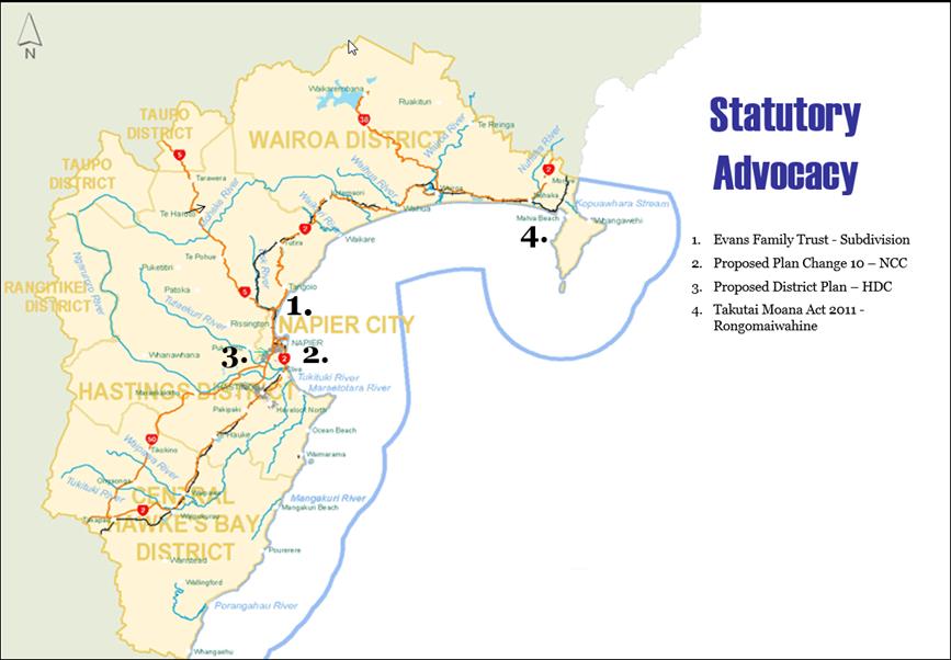
HAWKE’S BAY REGIONAL COUNCIL
Regional
Planning Committee
Wednesday 16 September 2015
SUBJECT: Minor Items Not on the Agenda
Reason for Report
This document has been
prepared to assist Councillors note the Minor Items Not on the Agenda to be
discussed as determined earlier in Agenda Item 6.
|
Item
|
Topic
|
Councillor
/ Staff
|
|
1.
|
|
|
|
2.
|
|
|
|
3.
|
|
|
|
4.
|
|
|
|
5.
|
|
|