Meeting of the Environment and Services Committee
Date: Wednesday 13 August 2014
Time: 9.00am
|
Venue:
|
Council Chamber
Hawke's Bay Regional Council
159 Dalton Street
NAPIER
|
Agenda
Item Subject Page
1. Welcome/Notices/Apologies
2. Conflict
of Interest Declarations
3. Confirmation of
Minutes of the Environment and Services Committee held on 11 June 2014
4. Matters Arising
from Minutes of the Environment and Services Committee held on 11 June 2014
5. Follow-ups from
Previous Committee Meetings 3
6. Call for any Minor
Items Not on the Agenda 7
Decision Items
7. Update on Karamu
Enhancement Work 9
8. Land Management
Operational Plan 2014/15 15
Information or Performance Monitoring
9. Compliance
Reporting Update 37
10. Land Science Soil Quality
Update 39
11. Science Report:
Hawke’s Bay Biodiversity Inventory – Current State of Knowledge 43
12. Statutory Advocacy Update 47
13. Minor Items Not on the Agenda 53
HAWKE’S BAY REGIONAL COUNCIL
Environment
and Services CommitteE
Wednesday 13 August 2014
SUBJECT: Follow-ups from Previous Committee
Meetings
Reason for Report
1. Attachment 1 lists items
raised at previous meetings that require follow-ups. All items indicate who is
responsible for each, when it is expected to be completed and a brief status
comment. Once the items have been completed and reported to the Committee they
will be removed from the list.
Decision
Making Process
2. Council is required to make a decision in
accordance with Part 6 Sub-Part 1, of the Local Government Act 2002 (the Act).
Staff have assessed the requirements contained within this section of the Act
in relation to this item and have concluded that as this report is for
information only and no decision is required in terms of the Local Government
Act’s provisions, the decision making procedures set out in the Act do
not apply.
|
Iain Maxwell
Group
Manager Resource Management
|
Mike Adye
Group
Manager Asset Management
|
|
Liz Lambert
Chief
Executive
|
|
Attachment/s
|
1
|
Follow-ups
from Previous Committee Meetings
|
|
|
|
Follow-ups
from Previous Committee Meetings
|
Attachment 1
|
Follow-ups from Previous Environment & Services
Committee Meetings
11 June 2014
|
|
Follow-up/Request
|
Person Responsible
|
Due Date
|
Status/Comment
|
|
|
Invite Parliamentary Commissioner for the Environment
to Hawke’s Bay
|
CE
|
13/8
|
The Parliamentary Commissioner for the Environment is
delighted to have received an invitation but regretfully is unable to travel
to Hawke’s Bay between now and the end of October, and highly unlikely
to by the end of 2014. HBRC and PCE officials will continue to look for the
earliest possible opportunity for a visit.
|
|
|
|
Consenting conditions relating to
burning of fires during certain times of the year
|
I Maxwell/M Heaney
|
13/8
|
A copy of ‘Outdoor burning Guide’
containing the required information to be provided to Councillors at next
meeting
|
|
|
|
|
|
|
|
|
HAWKE’S BAY REGIONAL COUNCIL
Environment
and Services Committee
Wednesday 13 August 2014
SUBJECT: Call for any Minor Items Not on the Agenda
Reason for Report
1. Under standing orders, SO 3.7.6:
“Where an item is not on the agenda
for a meeting,
(a) That item
may be discussed at that meeting if:
(i) that
item is a minor matter relating to the general business of the local authority;
and
(ii) the
presiding member explains at the beginning of the meeting, at a time when it is
open to the public, that the item will be discussed at the meeting; but
(b) No
resolution, decision, or recommendation may be made in respect of that item
except to refer that item to a subsequent meeting of the local authority for
further discussion.”
2. The Chairman will request any items councillors wish to be added for
discussion at today’s meeting and these will be duly noted, if accepted
by the Chairman, for discussion as Agenda Item 13.
|
Recommendation
That the
Environment and Services Committee accepts the following minor items not on
the agenda, for discussion:
|
|
Paul Drury
Group
Manager
Corporate
Services
|
|
HAWKE’S BAY REGIONAL COUNCIL
Environment
and Services Committee
Wednesday 13 August 2014
SUBJECT: Update on Karamu Enhancement Work
Reason for Report
1. Te Karamu
Catchment Review and Options for Enhancement is a significant project adopted
by Council in February 2004. It has been nearly a decade since the decision and
it is appropriate to look back over that time and discuss the achievements to
date.
2. This paper
provides a succinct outline of the project’s objectives and work carried
out since 2007 when physical work on the project began. It also seeks
approval from Council to delegate authority to the Chief Executive for ongoing
negotiation and potential purchase of a parcel of land in the vicinity of the
confluence of the Karamu and Ruapare Streams.
Background
3. The project is
part of the Heretaunga Plains Flood Control and Drainage Scheme, specifically
under Rating Area 6, project 296-Karamu and Tributaries and project 288-HP
Special Projects (Clive River).
4. The original
proposal in 2004 was for total project works costing $14 M made up of $5M
construction costs, $8M enhancement costs and $1M land taking costs.
5. Physical works
initially started in 2007 with an allocation of $100,000 per annum plus an
additional $10,000 for maintenance, increasing by $10,000 each year to cover
the previous year’s enhancement work. The annual amounts have remained
more or less the same for the past eight years and recently an additional
$40,000 per year was allocated specifically for use on marae based enhancement
work in the Karamu catchment. This is to recognize the value Māori place
on restoring the waterways and the willingness of hapu to work with Council on
achieving good outcomes for the health of the river.
6. The project is
part of the Asset Management Team responsibilities managed by the Engineering
Section with site work, implementation and maintenance managed by the Open
Spaces team. The Works Group and Science team are also involved in the project
from time to time.
7. Te Karamu
project is about natural asset management which means that it is an integrated
approach of managing not only the essential functions of drainage and flood
hazard mitigation, but as well the relationship between the land and the water.
The emphasis is on planning and management to take into account the natural
dynamics and diversity of waterways and work with nature to protect and enhance
ecological values.
8. There is no
doubt that some of the development practices that have delivered prosperity to
the wider Heretaunga Plains community have simultaneously compromised the
natural waterway resources. Poor water quality from both urban and rural
sources is an undesirable feature of the current Karamu waterway; disliked by the
public and deeply offensive to Māori, particularly hapu who have lived
beside and been nourished by the waterways for centuries. This project is
taking the first steps to remedy the situation and bring Te Karamu back to
health. Toitū te taiao, toitū te tangata (If the environment is
healthy, then the people will prosper).
9. This project
includes many of Council’s key strategic goals around sustainability,
water, open spaces, partnerships with Māori and operational activities. It
directly relates to good social, cultural and environmental wellbeing and has
been a catalyst in formulating the Council Waterway Management Philosophy.
10. This philosophy, endorsed
by Council in August 2007 is for streams and drains administered as part of a
Council flood control and drainage scheme flowing through public land to be
managed using a multi-value approach, which where appropriate creates improved
ecological, recreational, heritage, cultural, landscape and drainage values
within the waterway network, and that communities take ownership of, and have
pride in, their waterways.
Progress to Date
11. Part of the physical
construction works involves removal of the floodgates at Pakowhai and widening
the channel above the floodgates. A favourable opportunity to purchase land on
the right bank of the Karamu Stream (from PPCS) was carried out early in the
project to enable the widening to take place, sometime in the future. The bulk
of this widening will be carried out (in 2015) through an agreement reached
with HDC as part of the Whakatu Arterial Link Road, using the excavated soil
for the bridge approach filling.
12. Negotiations have been
ongoing over the removal of the floodgates and carrying out work around the
Pakiaka urupa. This is a culturally significant area and past grievances over
the mishandling of sensitive burial areas still linger. Agreement in principle
has now been reached subject to the purchase of the link road surplus land
provision for an alternative urupa. Negotiations with the landowner and HDC are
continuing as is planning for this area. With the goodwill of all involved the
Pakowhai area provides an exciting regional development opportunity (as
indicated in the Te Karamu report) that provides a link with Pakowhai Country
Park together with being able to highlight some of the Māori and early
European history in the area. This location is rich in history with some
wonderful stories associated with the area. Staff will present to Council more
detail on the opportunities and suggestions for the area at the meeting.
13. Staff are keen to progress
these discussions, but require Council agreement to potential unbudgeted
expenditure should ongoing negotiations lead to the opportunity to purchase
land necessary to achieve this outcome. Staff propose that the purchase
be funded from the Heretaunga Flood Control and Drainage Scheme – Rivers,
which holds a credit balance of approximately $400,000 at the close of the
2013/14 financial year. It should be noted however that 30% of all
operational and capital expenditure under this Scheme is sourced from general
funding. It is proposed that the general funded portion of this purchase
amount is funded from the community facilities borrowing provision provided for
in the Annual Plan.
14. Riparian planting has been
a significant part of the work to date and has certainly been a popular
activity with a great number of the public and interested groups including
local hapu. An offshoot of the project has been Operation Patiki run by
Kohupatiki Marae and supported by HBRC. This operation involves survey of the
Patiki (Black Flounder) to look at the decline in numbers and possible causes.
The operation also has a considerable planting and maintenance programme to
look after their section of the Clive River with support when requested from
HBRC. Other marae in the Karamu catchment have similar aims and we are working
alongside them to help achieve common goals.
15. Likewise many of the
neighbouring properties are doing their own planting and assistance is provided
by HBRC as required. The list below includes most of the groups and individuals
HBRC has supported.
Adjacent landowners HBRC has supported include:
· Nick Pattison (LB between Bridges in Havelock North)
· Cliff Poynter (LB between Bridges in Havelock North)
· Tony Neil (Whakatu)
· Alistar Curtis (Napier Rd)
· Gareth Donnelly
· Hamish & Andrea Gibbs (Grassmere Rd)
· Kay Walker (Napier Rd)
· Bruce McMillan (Farmlet Rd)
Marae & Community Groups HBRC has supported include:
· Karamu Enhancement Group (KEG) (Havelock North)
· Clive Community Group (Clive)
· Kohupatiki Marae
· Whakatu (Des Ratima / Aki Paiper)
· Forest & Bird (Whakatu, Ruahapia, Pakipaki)
· Houngarea Marae (Pakipaki)
· Ruahapia Marae (Representing the 4 Marae of Ngati Hawea)
· Mangaroa Marae (Bridge Pa)
· Karongata Marae (Bridge Pa)
· Genesis Shadehouses in schools
· Flaxmere College (practical work streams)
· Various schools
· Hohepa residents
· Mary Doyle life care complex
In terms of schools and education we have
provided planting and education opportunities for 10 plus schools in any given
year on Te Karamu project.
16. Enhancement work to date
is shown in the following table:
|
DATE
|
LOCATION
|
ACTIVITY
|
|
2007: Stage 1
|
Right bank,
upstream of Herehere confluence to Gilpin Rd.
|
Approx. 0.83
km. Wetland creation, extensive planting, weed control.
41,727
plants.
|
|
2008: Stage 2
|
Right Bank
downstream of Crosses Road
|
Approx. 1 km.
Preparation and planting. Modified plant species based on what was learnt
from stage 1.
15,739 plants
Land
ownership / agreements. Maintenance.
|
|
2009: Stage 3
|
Herehere to
Crosses Rd.
|
Approx. 1.9
km. Existing parkland setting, outfall plantings, stream edge planting and
infill planting.
7,000 plants.
Initial
planting at Kohupatiki (3,000 plants).
|
|
2010: Stage 4
|
Anderson Park
to Herehere Stream
|
Approx. 0.75
km. Edge planting and infill.
3,500 plants.
Kohupatiki
1,500 plants
|
|
2011: Stage 5
|
Ruahapia,
opposite marae.
Kohupatiki,
LB Clive
|
Approx 1.2
km. Stormwater outlet wetland created (Ruahapia Drain).
12,000 plants
|
|
2012: Stage 6
|
Ruahapia
|
Ruahapia
Stage 2,
12,457 plants
Whakatu
planting assistance and Awanui at Pakipaki.
|
|
2013: Stage 7
|
Ruahapia to
SH2 Bridge
RB between
Havelock Bridges
|
Ruahapia
Stage 3 from rail bridge upstream 0.8 km.
Whakatu and
Awanui.
14,906 plants
|
|
2014:
|
Infill and replacement
of stages 1 to 7.
Poukawa
Stream, Pakipaki
Karewarewa,
Bridge Pa
|
Time needed
to catch-up on all the previous work. Replace lost plants and more
maintenance. Marae based work continued. Whakatu planting. Work with
neighbouring properties.
Work on
Poukawa Stream at Pakipaki to link with Peka Peka swamp.
Bridge Pa
preparation and planting.
5,699 plants
|
|
|
Total
|
In excess of
114,500 plants have been planted since 2007. Many of the areas planted are
due to be selectively planted with larger tree species in the coming years
now that good ground cover is getting established.
|
17. The next steps in this
project are:
a. Continue
with the annual enhancement works
b. Prepare
plans for Pakowhai area
c. Remove
old floodgates
d. Carry
out channel works and develop Pakowhai area.
18. Te Karamu project resulted
in some significant improvements in the riparian areas where work has been done
to date. There remains a significant amount of work still to be carried out to
complete the report objectives. Progress is dependent on available funds which
generally means about 800 metres per side is currently achievable each year.
For the Karamu Stream and the Awanui there is over 32 km of river in addition
to the major tributaries.
19. Despite the daunting task
still ahead there has been great relationships developed and support for the
project from a wide range of people and organisations keen and willing to help.
Although progress appears slow, there is never-the-less clear evidence of the
success of this project to date.
Decision Making Process
20. Council is required to
make every decision in accordance with Part 6 Sub-Part 1, of the Local
Government Act 2002 (the Act). Staff have assessed the requirements contained
within this section of the Act in relation to this item and have concluded the
following:
20.1. The decision
does not significantly alter the service provision or affect a strategic asset.
20.2. The use of
the special consultative procedure is not prescribed by legislation.
20.3. The decision
does not fall within the definition of Council’s policy on significance.
20.4. The persons
affected by this decision the potential users of the open space area and people
with mana whenua over the land in the vicinity of the confluence of the Karamu
and Raupare Streams.
20.5. This is part
of an initiative for the enhancement of the Karamu Stream and its
environs. It is more specifically an essential part of a project to
remove the old Karamu floodgates which are an impediment to the flood capacity
of the Karamu Stream. Significant discussions and negotiations with
people with mana whenua over this land have been held over the past several
years with many options being explored.
20.6. The decision
is not inconsistent with an existing policy or plan.
20.7. Given the
nature and significance of the issue to be considered and decided, and also the
persons likely to be affected by, or have an interest in the decisions made,
Council can exercise its discretion and make a decision without further
consulting directly with the community or others having an interest in
the decision.
|
Recommendations
That the Environment
and Services Committee receives the report.
The Environment and Services Committee recommends that Council:
1. Agrees
that the decisions to be made are not significant under the criteria
contained in Council’s adopted policy on significance and that Council
can exercise its discretion under Sections 79(1)(a) and 82(3) of the Local
Government Act 2002 and make decisions on this issue without conferring
directly with the community and persons likely to be affected by or to have
an interest in the decision due to the nature and significance of the issue
to be considered and decided.
2. Delegates
authority to the Chief Executive to purchase land in the vicinity of the
confluence of the Karamu and Raupare Streams to enable the facilitation of
the removal of the old Karamu flood gate structure, provide for the possible
expansion of the Pakowhai Regional Park, and potentially to enable an area to
be set aside for an urupa; with 70% of the funding being sourced from the
Heretaunga Plains Flood Control Scheme – Rivers, and 30% from the
community facilities borrowing provision.
|
|
Gary Clode
Manager
Engineering
|
Mike Adye
Group
Manager
Asset
Management
|
Attachment/s
There are no
attachments for this report.
HAWKE’S BAY REGIONAL
COUNCIL
Environment
and Services Committee
Wednesday 13 August 2014
SUBJECT: Land Management Operational Plan
2014/15
Reason for Report
1. The Land Management Team (LMT) has primary responsibility for the
delivery of the sustainable land management function within Council. The land
management operational plan outlines the range of activities that will be
undertaken in the 14/15 financial year to progress Council’s strategic
objective of more viable and resilient farming systems in the region through
sustainable land use. The operational plan is prepared annually and staff
report back on the plan within five months of the end of the financial year.
The Operational Plan appended to this paper for Committee reference is
available to other parties on request.
2. This agenda item seeks Council adoption of this operational plan for
the 2014/15 financial year.
Comment
3. The National Policy Statement for Fresh Water and its associated
catchment based plan changes are bringing about a significant period of change
in the management of land and water. The land management operational plan
reflects the likely direction of these changes in its commentary on team
activities for the 14/15 financial year.
4. The current resourcing and other impacts of plan changes such as Plan Change 6 (PC6) are not yet certain. As
such it is important that the LMTs approach remains flexible as clarity is
built on the most effective approaches and solutions for plan change implementation.
The LMT approach may therefore change from this operational plan as the 2014/15
year progresses.
5. Land Management Operational Plan:
5.1 Key work programmes included in the 2014/15 operational plan are:
5.1.1 Supporting
policy Implementation of PC6 in the Tukituki Catchment.
5.1.2 A more
strategic approach to hill country resource management
5.1.3 The
capacity building, research priorities and strategic relationship management
critical to the effective long term delivery of the LMTs activities.
Decision Making Process
6. Council is required to make a decision in
accordance with the requirements of the Local Government Act 2002 (the
Act). Staff have assessed the requirements contained in Part 6 Sub Part 1
of the Act in relation to this item and have concluded the following:
6.1 The decision
does not significantly alter the service provision or affect a strategic asset.
6.2 The use of the
special consultative procedure is not prescribed by legislation.
6.3 The decision
does not fall within the definition of Council’s policy on significance.
6.4 The persons affected by this
decision are the beneficiaries of Council’s land management programme
which includes the public of Hawke’s Bay.
6.5 Options have
been canvassed through HBRC’s Strategic Plan, consultation on Plan Change
6, the implementation plan considered as part of the Board of Inquiry hearing
into Plan Change 6, and discussions with primary sector stakeholders.
6.6 The decision is
not inconsistent with an existing policy or plan.
6.7 Given the nature
and significance of the issue to be considered and decided, and also the
persons likely to be affected by, or have an interest in the decisions made,
Council can exercise its discretion and make a decision without consulting
directly with the community or others having an interest in the
decision.
|
Recommendations
That the
Environment and Services Committee recommend to Council that it:
1. Agree that the decisions to be made are not significant under the
criteria contained in Council’s adopted policy on significance and that
Council can exercise its discretion under Sections 79(1)(a) and 82(3) of the
Local Government Act 2002 and make decisions on this issue without conferring
directly with the community and persons likely to be affected by or to have
an interest in the decision due to the nature and significance of the issue
to be considered and decided.
2. Adopt the Land Management Operational Plan 2014/15 including any
amendments agreed by the Committee and Council.
|
|
Nathan Heath
Land
Services Advisor
|
Campbell Leckie
Manager
Land Services
|
|
Mike Adye
Group
Manager
Asset
Management
|
|
Attachment/s
|
1
|
Land
Management Operational Plan 2014/15
|
|
|
|
Land
Management Operational Plan 2014/15
|
Attachment 1
|
HAWKE’S BAY REGIONAL COUNCIL
operational plan
Land MANAGEMENT
july 2014 – june 2015

Prepared by: Nathan Heath
Land
Services Advisor
6
August 2014
|
Land
Management Operational Plan 2014/15
|
Attachment 1
|
TABLE OF
CONTENTS
1. INTRODUCTION......................................................................................................... 3
2. LAND MANAGEMENT TEAM
ROLE.......................................................................... 3
3. LAND MANAGEMENT PROGRAMS
......................................................................... 4
3.1
Supporting policy Implementation of Plan Change 6 in the Tukituki Catchment............................................................................................................. 4
3.2 A more
strategic approach to hill country resource
management.......................................................................................................... 5
3.3 Improving environmental performance of
forestry.......................................... 7
3.4 Environmental enhancement and biodiversity
protection.............................. 7
4. 2014-15 LAND MANAGEMENT
ACTIVITY................................................................. 8
4.1 Foresight &
strategy......................................................................................... 8
4.2 Investment....................................................................................................... 10
4.3 Strategic
Alliances........................................................................................... 14
4.4 Fit for purpose
organisation............................................................................. 16
5. PROGRAM ALIGNMENT AND DELIVERABLES
2013-14......................................... 16
6. SUMMARY.................................................................................................................. 17
7. APPENDICES............................................................................................................. 18
1.0 INTRODUCTION
This operational plan describes how the
Land Management Team (LMT) of the Hawke’s Bay Regional Council (HBRC)
will meet its objectives as outlined in the Long Term Plan (LTP). The
operational plan will be presented to Council for approval at the commencement
of each financial year. Performance against the operational plan will be
presented to Council within five months of the close of a financial year. This
operational plan is effective from 1 July 2014 to 30 June 2015. The plan
documents the following:
· The role of the Land Management
Team in the Hawke’s Bay Regional Council.
· The link between LMT activity
for the period 1 July 2014 to 30 June 2015 and the outcomes outlined in the
HBRC Strategic Plan, HB Land & Water Management Strategy and Long Term
Plan.
· The key program areas for the
LMT and its response to address these issues.
· The LMT program activities for
2014-15.
2.0 LAND
MANAGEMENT TEAMS ROLE
The LMT’s areas of focus and
objectives are set by the HBRC Strategic Plan and Land and Water Management
Strategy outcomes and outputs. Actions and performance targets to achieve these
strategic objectives are defined by the LTP via the strategic enablers of
– foresight and strategy, investment, strategic alliances and a fit for
purpose organisation. The operational plan shows how the LMT’s annual
activities will lead to the achievement of long term plan and annual plan
performance targets and contribute towards achieving the outcomes of the
Strategic Plan as shown in Appendix 1.
The LMT plays a key role in implementing
the non-regulatory policies and programs of the HBRC and in facilitating the
wider adoption of sustainable land management throughout the Hawke’s Bay
Region, in accordance with HBRC Resource Management Plans. The
LMT structure is shown in figure 1.
 Figure 1. Land Management team structure
3.0 LAND MANAGEMENT PROGRAM AREAS
The LMT’s program focus
for the following financial year is around the following key themes
· Supporting policy Implementation of Plan
Change 6 (PC6) in the Tukituki Catchment.
· A more strategic approach to hill country
resource management
· Improving environmental performance of forestry
in the region
· Environmental enhancement and biodiversity
protection
3.1 Supporting policy Implementation of
Plan Change 6 in the Tukituki Catchment
Significant work is currently occurring
across HBRC in developing an Implementation Plan for PC6 by 31 December 2014
and in considering the logistical and resource implications of that plan on our
Long Term Planning process. Both of these processes will have a significant
impact on Land Managements future operational activities, as the group will play
a key role in the implementation of PC6.
Land Managements role in the
implementation process was outlined in the Draft Tukituki Catchment
Implementation Plan (TCIP) (Heath 2012) and adopted by Council 27 February
2013. The EPA Boards final decision for PC6 differed to that which the TCIP was
originally written for and while that final decision endorsed significant
components of the TCIP it also brought a number of new and additional demands
on the Land Management team that will need to be considered over the next 6
months. For example clarifying the teams role in the preparation of 1042 Farm
Environmental Management Plans (FEMP’s) now required in PC6. A
brief outline of Land Management’s potential role in PC6 implementation
includes -
· The priority sub-catchment program currently being
piloted in the Papanui catchment, which gives effect to PC6 Objective TT2,
“Where the quality of fresh water has been degraded by human activities
to such an extent that OBJ TT1 is not being achieved, water quality shall not
be allowed to degrade further and it shall be improved progressively over time,
so that OBJ TT1 is achieved by 2030”.
· Utilising our strategic alliances with the primary
sector in the development of programs and process such as the Memorandum of
Understanding for Industry Good Practice – Phosphorus, signed by nearly
all members of the HB Pan Sector Group in October 2012, that help give effect
to PC6 Objective TT4a “To recognise that industry good practice for land
and water management can assist with achieving Objective TT1, TT2 and
TT4”.
· Providing key support to the achievement of Objective
TT1 “To sustainably manage the use and development of land, the discharge
of contaminants including nutrients, and the taking, using damming or diverting
of fresh water in the Tukituki Catchment” through the following key
functions –
o Providing support to communities and individuals in
interpreting, understanding and applying the new rules and regulations within
PC6 cost effectively and technically appropriate on-farm.
o Helping build capacity in the region to deliver the
1042 FEMP’s required by 1 July 2018 through -
§ Supporting the development of FEMP delivery capacity
by liaising closely with potential providers.
§ The development of templates and procedural guidelines
in collaboration with the primary sector and private consultants to ensure the
FEMP are delivered consistently and effectively across the region
§ Providing the delivery of FEMP’s in priority
sub-catchments where the intensity and complexity of FEMP’s needs to be
sufficient to “claw back” degraded water quality.
§ Technical auditing – ensuring that FEMP’s
undertaken by external providers are appropriate and effective in realising the
water quality objectives in PC6.
3.2 A more strategic approach to hill
country resource management
The provincial economies of the East
Coast of the North Island are heavily dependent on the use of their hill
country resource. The hill country represents perhaps our greatest potential
opportunity for economic growth but it is also one of the greatest liabilities
in achieving the sustainable use of natural resources in the region.
Hawke’s Bay has one of
the highest rates of hill country erosion in New Zealand, and New Zealand one
of the highest rates of erosion in the world. This erosion results in the
loss of the productive capacity, carbon, nutrients and potential water storage
of soils. Offsite impacts include sedimentation of waterways, river aggradation
and damage to infrastructure (McKay 2008).
Sedimentation is a major threat
to the region’s water quality, and is a key issue to be considered as
part of our implementation of the National Policy Statement – Freshwater.
Reducing soil erosion and sedimentation is complex because it occurs in
landscapes where geology, climate, and farm incomes combine to create few
viable but costly solutions to the problem, which often exist in competition to
landholder’s short and long term economic and environmental goals for
their properties. It is an issue that requires a new and innovative approach to
how we deal with this challenge.
The current primary mechanism
for addressing this issue is the Regional Landcare Scheme’s (RLS) pole
planting program, subsidisation of the Soil Conservation Nursery and support to
landholders by staff for the planning and implementation of soil conservation
programs and tailored farm plans. These processes have had a significant impact
at reducing soil erosion in hill country throughout Hawke’s Bay (an
estimated 440,000 poplar and willow trees planted on 11,000ha) but this equates
to only around 7% of the 150,000 ha of steep highly erodible farmland in the
region.
A new approach is being
considered as part of the East Coast Hill Country Resilience proposal. The
proposal is effectively looking at forming an adaptive governance group
involving central, regional and local government, primary sector, Iwi, land holders
and community members along the East Coast of the North Island. The group will
consider the long term and holistic social, cultural, economic and
environmental resource management challenges to the resilience of hill country
and collectively develop strategies and programs to meet these challenges. This
approach could significantly improve the efficiency of our catchment planning
process by enabling us to consider how we can collectively give effect to the
NPS in hill country en mass. Significant support to this proposal has
already been given by most of the key stakeholders to the proposal.
The LMT in collaboration with
Land Science have been investigating options for improving the efficiency and
effectiveness of erosion control measures and value of RLS investment in
reducing soil loss on-farm, through investigations into sediment sources, a
review of the effectiveness of historical erosion control plantings and
consideration of the wider ecosystem service benefits soil conservation
plantings bring to the region. This information will be presented to Council in
October. An example of these findings is outlined below.
Dr Dominati (AgResearch) in
collaboration with HBRC looked at quantifying the impact and cost of the loss
of ecosystem services from HB hill country following on from the April 2011
storm event along the southern HB coast, where an estimated 37km2 of
new bare ground was created through erosion. Dr Dominati looked at costs that
were in addition to the estimated $39 million cost to infrastructure, land,
personal and commercial property, by considering the impact of erosion on
ecosystem services like the filtering of nutrients and contaminants, flood
mitigation, carbon sequestration, greenhouse gas regulation and food
production. She estimated that the total value of ecosystem services provided
by uneroded hill country were approximately $5,085 ha/yr for rolling land and
$3,717 ha/yr for steep land, of which only 12-14% of that value was made up
from the value for food production. However once steep land eroded the value of
ecosystem services for that eroded area dropped to $1,299 ha/yr, recovering to
$1,921 ha/yr after 20 years and still only $2,293 ha/yr after 50 years
following on from the erosion event. Conversely Dr Dominati looked at the value
of wide spaced trees planted in steep land, both on their value in preventing
the loss of ecosystem services caused by erosion and also considering other
potential benefits trees in that landscape would bring e.g.). Provision of
shade, native faunal habitat and food sources, alternative fodder for stock and
wood. She estimated that the value of ecosystem services provided by uneroded
steep land increased to $4,165 ha/yr 10 years following on from the
introduction of trees and to $4,545 ha/yr after 20 years when they were
harvested.
The LMT will continue to
explore additional opportunities, initiatives and programs that work closely
with landholders, communities and industry to address these issues. This
includes;
· Participation in the High Performance Manuka Primary
Growth Partnership (PGP). This PGP programme is a $1.8m 5 year research
programme designed to significantly increase the returns and performance of
high UMF Manuka plantations.
· Improving the cost benefit of RLS soil conservation
investment in collaboration with the Land Science team by undertaking work in
characterising the source, mechanisms, timing and impact of sediment loss
within priority catchment areas. The objective being to better target
investment to appropriate erosion control mechanisms to address soil loss when
and where it occurs.
· Continued support of landholder capacity building
through the provision of workshops and field days and support of the Ballance
Farm Environment Awards.
· Synergies and strategic alliances with the primary
sector industries. For example Beef & Lamb NZ by promoting and supporting
the use and adoption of Land & Environment Plans (LEP’s) by hill
country landholders.
3.3 Improving environmental performance
of forestry
HBRC’s current forest asset will be
largely in a maintenance i.e. (not new forest establishment) phase from the
2014-15 financial year with most new planting across the forests completed.
Staff are looking to maximise the investment return from the forest asset and
will consider initiatives to reduce operational costs such as re-tendering the operational
management currently contracted out. In addition staff will actively seek to
integrate the wider social, environmental or recreational opportunities
available within the forest asset. Staff have an active programme of engagement
with the Hawkes Bay forest industry to improve HBRC and industry environmental
performance. This includes:
· Forest Estates - providing for best multiple use
forestry and commercial efficiency in the HBRC forest estate and Tangoio Soil
Conservation Reserve. Apply industry good practise in management plans
and forest activities.
· Forest Industry engagement - support excellence in
land stewardship and a successful HB forest industry. Attend bi-annual HB
Forestry Group meetings. Use aerial and satellite imagery to review
recent forest roading and harvest operations. Make at least six forest visits
to review forest roading and harvest operations.
· Forest Extension - promote forest establishment where
appropriate to improve HBRC values in hill country Hawke’s Bay
· Forest Research - participate in R&D projects to
improve environmental health and commercial prospects for forests, NZ Dryland
Forests Initiative and other industry activities as appropriate.
3.4 Environmental enhancement and
biodiversity protection
RLS investment on private land to assist
landholders protect and enhance areas of significant biodiversity is a priority
of the LMT. Several LMT staff are involved in the development of the HB
Biodiversity Strategy, currently being facilitated by HBRC. This strategy is
due for completion in December 2014. As the Biodiversity Strategy progresses it
is anticipated that the LMT will play a role in “operationalising”
components of the strategy. Critical to this will be ensuring RLS investment is
aligned and prioritised where on-ground investment are of greatest multiple
benefit and also where investment in nutrient mitigation practices or soil conservation
projects in other priority areas like the Tukituki catchment can lead to
additional biodiversity outcomes. Programs or processes currently being
developed or considered by the LMT include –
· A review to consider how we can better brand and
advertise biodiversity project investment on private land, through better
signage, marketing and communications via farm case studies and articles in
publications.
· A large scale project called Cape to City which is
seeking to partner with other funders to complete 20-30km of riparian planting
on the Maraetotara River. This project will also see a number of threatened or
endangered species populations enhanced in partnership with the Cape Sanctuary.
· A programme called Trees at Cost. This is a regional
initiative managed by the land management team to get quality low cost riparian
plants available to ratepayers with a focus on those areas where planting is
taking place to meet the requirements of plan changes. HBRC is working in
partnership with the large scale Taranaki Regional Council riparian programme
to gain the cost savings possible for plants purchased under their programme.
A number of significant community based
initiatives will continue to play an important role in the biodiversity program
including –
· Coastal Dunes restoration projects
· Maraetotara Tree Trust
· Tutira Poutiri project
4.0 2014-15 LAND
MANAGEMENT ACTIVITY
The following section outlines the wider
activities the land management team will be involved in over the following 12
months and how these will contribute to the performance targets derived from
the LTP as shown in appendix 2.
4.1 Foresight
& STRATEGY
The LMT is playing a significant role in
supporting the strategic development of organisational approaches to a number
of key resource management challenges including –
1. The development of an organisational
PC6 implementation plan as mentioned in the previous section by enabling
–
o The development of consistent and consensual
interpretation of rules and regulations through facilitating the development of
procedural guidelines with primary sector stakeholders.
o The consideration of LM program logistics &
resourcing – how we are going to deliver and afford PC6 in an effective
and efficient manner.
o The consideration of best practice approaches –
providing guidance on the most technically appropriate approaches to realising
freshwater objectives via mitigation actions taken on-farm.
o Opportunities for synergies, innovation and
efficiencies to our processes by working proactively both within HBRC and with
our external stakeholders.
2. Playing an active role in the
Taharua/Mohaka and Tutaekuri, Ahuriri, Ngaruroro & Karamu catchment plan
development through -
o Providing nutrient modelling science support and farm
systems interpretation and analysis.
o Facilitating industry participation and input into
plan change and program processes.
o Facilitating and managing catchment stakeholder
processes and participation in the design of local solutions to water quality
problems e.g.) Taharua catchment.
o Providing guidance on the practicalities, implications
and economic impact of permitted activity rules and policies on landholders
within the catchments.
o Producing implementation plans and processes to drive
the implementation of policy, rules and regulation on-ground.
3. Facilitating the development of
sub-catchment community based strategies to deal with significant water quality
challenges in the Taharua and Papanui catchments, with the Porangahau stream
strategy development to begin in September 2014.
4. The development of the East Coast Hill
Country Resilience Proposal mentioned in the previous section.
4.2 Investment
4.2.1 Research
The LMT Research investment is based on
the following key principles –
1. Alignment with Councils strategic
objective of “More viable and resilient farming systems in the region
through sustainable land use”.
2. Leverage – the LMT will look to
invest strategically in research projects that return good value to that
investment in terms of extending reach, reducing costs and adding value.
3. Collaboration and partnership –
with industry sectors will enable the LMT to better target its investment to
deliver on outcomes. Partnerships with industry also increase the likelihood of
applied research being adopted into industry best practice
Table 1, summarises the existing LMT
research program for 2014-15, and includes the deliverables from each of the
research projects during this period.
Table 1. Research Projects 2014-15
|
Title
|
Description
|
Deliverables 2013-14
|
|
Mitigating the Economic Costs to Farmers Following Severe
Rain Storm Events project
|
Evaluating the economic cost of storm damage and benefits
of soil erosion controls on the southern HB coast
|
· Production of farm case studies
· Farm erosion cost calculator
|
|
Dryland forest project
|
Investigation of the use of hardwoods in hill country
farming systems
|
· Research updates
|
|
Willow & Poplar Research Program
|
Support the breeding programme which develops new disease
resistant and site tolerant varieties of P & W
|
· Research updates
|
|
SFF/FAR Tukituki Choices for Arable Farmers
|
Project investigating how the integration of different
cropping and livestock enterprises can raise the profitability and reduce the
environmental footprint of arable farmers in HB
|
· Nutrient budgets for a range of
crops established
· Gross margins prepared for range of
crops
· Scenarios developed for creation of
a tool to enable the assessment of different cropping rotations on profitability
and environmental footprint
|
|
High Performance Manuka Primary Growth Partnership (PGP).
|
A
$1.8m 5 year research programme designed to significantly increase the
returns and performance of high UMF manuka plantations
|
· 10 ha planting of riparian margins
with UMF manuka
· 2 x field days
· Trial updates
|
|
East Coast Dryland Project
|
Investigate and evaluate alternatives to existing pastures,
forages, and farming systems to increase farm resilience to climate
variability
|
· To be developed
· Will include field days and regular
updates
|
|
Trees for Bees
|
Assessing and developing recommendations for planting which
can be incorporated into the on-farm planting which takes place for other
reasons (e.g. erosion control, riparian). Increasing floral biodiversity will
benefit pollinators by improving spread and quality of feed supply.
|
· Extending the list of useful plants
and putting these into a flowering calendar to identify which are suitable to
fill key gaps.
· 2014-15 look specifically at
willows for early season pollen supply. From 2015 consider pollination issues
on Heretaunga plains
|
|
Adoption of Environmental Best Practice on Deer Farms
|
The development and extrapolation of best practice
guidelines for deer farmers
|
· Seminars & field days
· Short video to be produced
|
|
Wairoa Hill Country Project
|
In proposal to be confirmed - Investigate and promote more
profitable and sustainable hill country land use options
|
· Continued funding currently under
review by MPI
|
|
Deferred Grazing Project
|
In proposal to be confirmed – looking at deferred grazing
systems to improve productivity and reduce environmental impacts of soil loss
in dry environments
|
· Project application yet to be
considered
|
|
The LMT is also providing resource support to the following
land science research projects
|
|
S-MAP
|
Project to improve the quality and quantity of soil mapping
for the HB region
|
|
Project 339 202 Riparian investigations
|
To assess the condition and extent of riparian protection.
|
|
Project 339 203 Catchment Issues Investigations
|
To identify areas of concern (hot spots) within major
catchment areas (as described in Land & Water management strategy)
enabling HBRC to act proactively rather that reacting to environmental
issues.
|
|
Project 340 202 Soil Quality Monitoring
|
As part of the SOE monitoring will identify areas and
practices that are being degraded/degrading soil quality
|
|
Project 340 203 Land Use Monitoring
|
Identification of land use change is basic information
needed to inform council regarding policy direction and maintain/enhance
environmental sustainability.
|
|
Project 340 204 Erosion Monitoring
|
Monitoring to assist in identifying (i)
most ‘at risk’ areas (ii) quantify amount of erosion
taking place (iii) effects on water quality (iv) measure the
effectiveness of RLS plantings and other council schemes with regard to
erosion control (v) erosion occurring on the plains
|
|
Project 340 206 Wetland Monitoring
|
Identification, prioritisation and monitoring are all
essential components in the protection of our wetlands as required by the new
freshwater NPS
|
4.2.2 Capacity building
Capacity building plays an important role
in complementing the LMT’s research and RLS grant programs, through
extending research results, providing workshops and field days to landholders
who haven’t received RLS incentives and by maintaining momentum with
important regional issues outside of priority areas.
Capacity building is the process by which
people, organisations and communities further develop their understanding and
skills to successfully manage change. Building capacity focuses on
enhancing existing strengths and abilities, and developing new capabilities1.
1 NSW Natural Resource Management Capacity Building Guide
This year’s capacity building focus
is on supporting the strategies and programs being developed within the
priority sub-catchment by ensuring that voluntary actions taken by landholders
are cost effective, appropriate and enhances their ability to reduce their
impact on water quality. The LMT will achieve this by engaging in the following
processes where relevant:
1. Raising awareness of the water quality
issues and impact of land use practices on water quality within each priority
sub-catchment.
2. Providing field days and workshops
using local demonstration sites to provide land users with the necessary skills
to undertake their own on farm mitigation.
3. Developing the necessary tools and
knowledge resources for land users to refer to in interpreting the Plan Change
6 rules and regulations to their own properties.
4. Facilitating community engagement
meetings and sub-catchment governance groups.
Table 2 outlines the wider capacity
building program for 2014-15. Note that capacity building associated with
research projects is included in the research table.
Table 2. Capacity building program
2014-15.
|
Title
|
2013-14 Activity
|
|
Ballance Farm Environment awards
|
· Awards dinner
· Regional winner field day
· Participation in judging process
· Farmer feedback reports
|
|
Hill Country Resilience workshop
|
· Consider the long term strategic
resource management issues for East Coast Hill Country
|
|
Tukituki Plan Change 6 awareness raising meetings
|
· Supporting HBRC meetings for
landholders to understand implications of plan change
|
|
Papanui & Porangahau stream sub-catchment capacity
building programs to support PC6 implementation
|
· Awareness raising
· Community engagement around
strategy development and water quality issues
· Targeted workshops to address
dealing with specific land use issues e.g.) forage cropping, intensive
cropping on peat soils
· Specific skill development
|
|
Whakaki & Whangawehi sub-catchment capacity building
programs
|
· Awareness raising
· Targeted workshops to address
dealing with specific land use issues
· Specific skill development
|
|
Trees for bees project
|
· Co-ordinating local project group.
|
|
LandWISE Conference
|
· Annual conference
|
|
LandWISE activities
|
· HBRC representation on board
|
|
Farm Forestry Awards
|
· Regular field days and activities
|
|
McRae Farm Trust Field Day
|
· Regular field days
|
4.2.3 RLS incentives and grants
The investment focus for 2014-15 financial
year is on supporting the implementation of the TCIP, with particular emphasis
on the priority sub-catchments, while continuing to support wider program
objectives elsewhere in the region.
Table 3 outlines the LMT’s RLS
targets for the next financial year in comparison to the targets and their
achievement for the 2013-14 financial year.
Table 3. Priorities for on-ground
investment 2014-15
|
|
Target
2012-13
|
Achieved
2012-13
|
Target
2013-14
|
Achieved
2013-14
|
Target
2014-15
|
|
Wetland restoration and protection
|
5 projects
|
8 projects
|
5 projects
|
10 projects
|
5 projects
|
|
Riparian or stream retirement
|
15 project
|
29 projects
|
7 projects
|
16 projects
|
7 projects
|
|
Soil conservation
|
28,000 poles
140 properties
|
37,700 poles
277 properties
|
20,000 poles
100 properties
|
31,000 Poles
135 properties
|
20,000 poles
100 properties
|
|
Preservation of native bush
|
100 ha
|
96 ha
|
100 ha
|
33 ha
|
100 ha
|
|
Coastal (cliffs, dunes, estuaries)
|
0
|
0
|
2
|
2
|
1
|
|
Research projects initiated
|
2
|
2
|
2
|
4
|
1
|
|
Capacity building activities
|
7
|
23
|
20
|
15
|
20
|
|
Participants attending events
|
250
|
590
|
500
|
900+
|
500
|
|
Catchment management community engagement meetings
|
9 events
|
15 events
|
15 events
|
17 events
|
20 events
|
|
Trees at Cost riparian programme
|
-
|
-
|
10000 native trees sold
|
10000 native trees sold
|
60,000 native trees sold
|
· Fewer riparian projects for the next financial year as
the riparian planting program is developed and the funding for fencing is
stopped in the Tukituki catchment in recognition of the stock exclusion rule,
it is anticipated that this target will be significantly higher for the 2015-16
period..
· Greater emphasis on wetland projects with emphasis on
projects achieving both nutrient mitigation and biodiversity outcomes.
· Same investment and targets for indigenous vegetation,
noting that RLS funding for the QE2 partnership is a key activity to achieve
this target.
· A significant reduction in soil conservation poles
planted this financial year due to reduced availability of poles from the
nursery for the 2014-15 period.
· More emphasis on capacity building & community
engagement this year to compliment LMT’s other programs and priorities.
4.3 Strategic
alliances
Strategic alliances are a key function of
the LMT. They are critical to the success of programs and the achievement of
LMT objectives. These relationships benefit all of HBRC and enable the team to
leverage LMT resources with external stakeholders to maximise efficiency,
effectiveness and achievement of program outcomes. The LMT works with a wide
range of industry stakeholders and groups, agricultural intermediaries,
government agencies, community groups and mana whenua to affect the adoption of
sustainable land management practices.
The LMT continues to develop strong
relationships with the region’s land owners and primary sector
industries. The LMT regularly provides support and advice to landholders
through one on one contact on farm, through the team’s involvement in
community meetings and field days and in attending associated primary industry
events and activities.
Understanding the needs and barriers to
change of the region’s land owners is critical to the LMT’s program
success and it is through this interaction with regional stakeholders
collectively and individually where this understanding is developed
Table 4 outlines the formal strategic
alliances the LMT is responsible for over the 2014-15 financial year.
Table 4. Key Strategic Alliances for
2014-15.
|
Group/Project
|
Description
|
Participation
|
|
Pan-sector group
|
The Pan Sector Group was officially formed to
work collaboratively to drive continued investment into research and development
of regional initiatives around best practice and farm profitability. The
initial focus is on realising the potential benefits socially, economically
and environmentally of the RWSS but the group has increasingly played a key
role in helping shape and policies, rules and regulations within the Tukituki
Plan Change 6
|
AgResearch, Plant & Food, Beef & Lamb, Fed Farmers,
DairyNZ, Fonterra, PipfruitNZ, HortNZ, FAR, LandWISE, Massey Uni, Fertiliser
Assoc, HB Fruit Grower, HB Winegrowers, MPI, HBRC, McCains, Heinz Watties,
IrrigationNZ, Silver Fern Farms
|
|
Dairy Liaison group
|
Forum for dairy farmers and HBRC to maintain open
communication and achieve improvements in practices on farm. Also a
cross-council focal point to have a unified approach to the dairy sector
|
Dairy Farmers, HBRC, DairyNZ, Fonterra
|
|
Maraetotara Tree Trust
|
Restoration of the Maraetotara stream
|
Land holders, Maraetotara Tree Trust, HDC, DOC, local
schools
|
|
Nature Central
|
Collaborative program with the intention of coordinating
and delivering greater biodiversity outcomes around areas such as
infrastructure management and use, community engagement, widescale pest
management and landscape restoration
|
HBRC, GW Regional Council, Horizons Regional Council and
DOC
|
|
Waimarama, Mahanga, Porangahau stream, Kairakau, Mangakuri,
Waipatiki, Pourerere coastal dune groups
|
Restoration and protection of coastal dunes in
collaboration with local communities
|
Local Communities
|
|
Tutira Poutiri Project
|
Project aim is to re-introduce species to this area and
improve biodiversity
|
DOC, Poutiri project leader
|
|
Taharua Catchment Group
|
Implementation of programs and development of collective
agreement to the long term management of the Taharua stream
|
Land holders, and wider stakeholders
|
|
Lake Runanga community group
|
Planting and protection of Lake Runanga
|
Local residents
|
|
Hawkes Bay Farm Forestry assn
|
Hawkes Bay Farm foresters. A membership of around 200. Who
meet regularly and hold Field days
|
Land holders, primary sector and agricultural
intermediaries
|
|
Hawke’s Bay Forestry Group
|
This is a forum for discussing local forestry issues and
environmental outcomes and improvements in forest industry.
|
All major forest owners and some minor forest owners and
their representatives in HB
|
4.4 Fit for purpose organisation
The LMT is currently in the initial stages
of developing a strategic plan to ensure the team is best positioned and
equipped to deliver on Councils strategic objectives and in particular support
the implementation of PC6, which we will bring to Council for consideration,
early next year. At the time of preparing this report, 2 full day facilitated
workshops have been carried out to build the framework for the strategy, which
the team will further elaborate on over the next 6 months. Several key issues
to emerge out of the initial workshops that have further reinforced several
priorities the team already has for this year includes –
1. The development of a monitoring,
evaluation, reporting and improvement (MERI) plan. This was a key deliverable
from last year that was not achieved due to LMT role in the wider PC6 and EPA
Hearing process. The team has made some significant gains in this space however
with 2 members of the team attending training in the development of MERI plans
last year and a number of MERI initiatives being implemented as part of the
priority sub-catchment program including, the benchmarking of community
attitudes and practices of landholders in the priority sub-catchments and the
development of a P risk assessment tool.
2. Greater focus on training and skill
development within the LMT – 3 team members have undertaken the Advanced
Nutrient Management (Overseer ®) course at Massey University and a further
2 staff have undertaken the intermediate course over the last financial year. Particular
emphasis of skill development this year will be around catchment group
engagement and facilitation. The team continue to support and attend the
leading conferences and workshops relevant to LMT objectives.
3. A more considered approach to our wider
stakeholder engagement and communication strategy is required to ensure we
maximise our effectiveness in raising awareness and getting key messages across
given the impact of PC6 on. in both
The LMT continues to provide significant
support to a range of groups within Council in addition to those discussed
above including, supporting the land science and consents/compliance groups
through farm systems analysis and nutrient budgeting.
5.0 Program
alignment and deliverables for 2013-14
The LMT have made significant progress to
ensure its programs and processes are aligned with the strategic objectives of
Council. Appendices 1 and 2 show how the LMT uses the strategic enablers of
foresight and planning, investment, strategic alliances and a fit for purpose
organisation in its operational planning to achieve the performance targets and
deliverables within the LTP and annual plan. Annual operational activities and
targets are aligned with the overarching consolidated outcomes from the HBRC
strategic plan and the HB Land & Water Management Strategy as shown in
appendix 3.
6.0 Summary
The LMT has gone through a significant
period of change and will continue to do so over the next financial year. The
team has played a key role in the dominant activities within council. The team
has continued to review and improve on its processes and protocols throughout
the year.
The key programs for the next financial
year will continue to focus on the sustainable use of hill country, the
implementation of the Tukituki Catchment Implementation Plan, improving the
environmental performance of the regions forestry industry and the protection
and enhancement of the regions significant biodiversity.
|
Land
Management Operational Plan 2014/15
|
Attachment 1
|
HBRC Vision
A region with a vibrant community, a prosperous
economy, a clean and healthy environment, now and for future generations
|
|
 Appendix 1. Guiding principles of LMT
Operational Plan
Appendix 1. Guiding principles of LMT
Operational Plan


Appendix 2. 2014-15 deliverables and
proposed activities contributing to those deliverables.
|
Strategic Enabler
|
Key Program Areas
|
Annual 2014-15 Deliverables
|
2014-15 Activities
|
|
|
Foresight
& Strategy
|
Catchment Planning
|
· Minimum 18
weeks of LMT staff time participating in the catchment planning processes.
· Catchment
management community engagement meetings – 15 events
|
· Development
of procedural guidelines for catchment management activities to be compiled
– 30 April 2015
· Continuation
of LMT input into the development of the Mohaka-Taharua Catchment Plan -
ongoing
· Provision of
input into the TANK catchment plan – ongoing
· Continuation
of LMT input into the Ruataniwha Water Storage Scheme development –
Ongoing
· Produce
Catchment plan for Papanui catchment – 31 December 2014
· Lead the
development of community based sub-catchment management plans for the
Porangahau stream and Papanui catchments
· Continuation
of the development of catchment action plans for the Whakaki and Whangawehi
communities - ongoing
|
|
|
|
|
|
|
Plan Change 6 Implementation plan
|
· Organisational
PC6 Implementation plan to be prepared by 31 December 2014
|
· Finalise the
Tukituki Catchment Implementation Plan – 1 December
· Liaise with
external stakeholders to create procedural guidelines for PC6 by farming
sector and external providers of Farm Environmental Management Plans –
Ongoing
|
|
|
Investment
|
Regional Landcare Scheme
|
· RLS review
document produced
· The
operational plan documents RLS contribution to sustainable land management
targets 30 June 2015.
· 60% of RLS
funding is targeted to initiatives in Tukituki Catchment
|
· Wetland
restoration and protection – Target = 5 project
· Riparian or
stream retirement – Target = 7 projects
· Soil conservation
projects – 20,000 poles planted on 100 properties target
Indigenous
bush covenanted – 100 ha target
· Coastal cliff
or dune project = 1 project target
|
|
|
Capacity building
|
· Capacity
building activities – 20
· Participation
in capacity building events – 500 landholders
|
· Ballance Farm
Environmental Awards, field days and judging
· LandWISE
conference and activities
· Farm Forestry
Association field days and awards
· Tree for Bees
field days
· Field days
within sub-catchments to be organised to assist wider community adapt and
adopt good practice to address catchment issues - 5 events by 30 April
2015
· PC6 awareness
raising and interpretation workshops to assist farmers comply with PC6
– 5 events by 30 April 2015.
· Field days
and workshops as part of dunes program – 2 events 30 April 2015.
|
|
|
Research
|
· Initiate at
least one new research or research extension initiative annually.
· Dissemination
of knowledge through field days and farmer seminars
|
· Wairoa Hill
Country, FIT Deferred Grazing projects funding bids currently being
considered
· Development
of catchment strategies will identify key catchment issues to be addressed in
realising freshwater objectives, which will become priorities for research
e.g.) winter forage crop grazing management & / or intensive cropping
best practice on peat soils.
· Research
project deliverables for 2014-15 outlined in Table 1.
|
|
|
Strategic
Alliances
|
Pan-sector Group
|
· Procedural
guidelines for PC6 implementation & industry good practice program
developed by 31 May 2015
|
· Continued
facilitation and management of the pan-sector and dairy liaison group and
process
· Active
program to implement agreed objectives in IGP-P MoU with primary sector
|
|
|
Fit for
purpose
|
Monitoring, evaluation and reporting
|
· Draft Land
Management MER framework produced 30 June 2015
· Land
Management stakeholder engagement and communication strategy produced = 30
June 2015
· Land
Management Strategy produced 1 April 2015.
|
· The MERI plan
will incorporate community, Iwi and plan change indicators to which the
implementation programs will address. These will be identified by the
stakeholders themselves and by the modelling of in-stream water quality
through TRIM2
· Land
Management strategy will be developed through a series of in-house workshops
throughout the year.
|
|
|
|
|
|
|
|
Appendix 3. Alignment of LMT programs and projects to
the HBRC Strategic Outcomes
|
Outcomes
|
Improved
economic return with reduced environmental impact via best practice adoption
|
Diffuse
run-off from farms reduced
|
Sustainable
use of fragile hill country and steeplands
|
Improved
understanding & targeted investment of ecological servicing
|
Improved
community understanding of landscape appropriate best practice
|
Catchments
with existing water quality issues have integrated management plans developed
by the community
|
Water
quality trends in degraded catchments will be improving
|
|
Foresight & Strategy
|
|
· LM support of PC6 implementation
|
· East Coast Hill Country Resilience
Proposal
|
· LMT involvement in the development
of the biodiversity strategy
|
· Development of a industry good
practice program in collaboration with Pan-sector group
|
· Sub-catchment strategies for
Papanui, Porangahau stream & Whakaki
|
· LM support of PC6 implementation
|
|
· Tukituki Plan Change 6 Implementation
Plan
· Mohaka/Taharua Plan Change &
Tutaekuri, Ngaruroro, Ahuriri & Karamu Plan Change
· Whangawehi, Whakaki catchment plans
|
|
Investment
|
· Adoption of Environmental Best
Practice on Deer Farms
· SFF/FAR Tukituki Choices for Arable
Farmers project
|
· RLS investment in riparian and
wetland protection
· Papanui, Porangahau stream &
Whakaki sub-catchment programs and activities
· SFF / FAR Tukituki Choices project
|
· RLS investment in soil conservation
programs
· Dryland forest project
· Dryland Pastures Project
· Wairoa Hill Country Project
· Farm forestry activities and awards
· McRae Trust field day
|
· RLS investment in riparian and
wetland protection
· Trees for Bees project
|
· GRAAS economic impacts of erosion
project
· Awareness raising in relation to
Tukituki Plan Change 6
· Awareness raising and field days in
priority sub-catchments
|
· Papanui, Porangahau stream &
Whakaki sub-catchment programs and activities
|
· Papanui, Porangahau stream &
Whakaki sub-catchment programs and activities
|
|
· Ballance Farm Environmental Awards
· Willow and Poplar nursery
|
|
Strategic alliances
|
· Working with the pan-sector to
collaborate on initiatives and programs
|
· Industry Good Practice procedural
guidelines and collaborative programs developed
|
· East Coast Hill Country Resilience
Proposal
|
· Tutira Poutiri Project
· Nature Central MoU development
· Maraetotara Tree Trust Meetings
· Waimararama, Porangahau,
Mahanga Coastal Dune Groups
|
· Dairy Liaison group
|
· Papanui, Porangahau stream &
Whakaki sub-catchment programs and activities
|
· Papanui, Porangahau stream &
Whakaki sub-catchment programs and activities
|
|
· Pan Sector group
· Collaboration with Ruataniwha Water Storage Scheme team
|
|
Fit for purpose
|
|
· Catchment characterisation of
nutrient issues as part of sub-catchment programs in Papanui & Porangahau
stream
|
· 340 204 Erosion monitoring
|
· 339 202 Riparian investigations
· 340 206 Wetland monitoring
· 340 202 Soil Quality monitoring
|
· S-Map soil mapping project
· 340 203 Land use monitoring
|
· Catchment characterisation of
nutrient issues as part of sub-catchment programs in Papanui & Porangahau
stream
|
· Catchment characterisation of
nutrient issues as part of sub-catchment programs in Papanui & Porangahau
stream
|
|
· Development of a Land Management MERI plan
· Development of Stakeholder Engagement and Communication
strategy
· Development of Land Management Strategy
|
HAWKE’S BAY REGIONAL COUNCIL
Environment
and Services Committee
Wednesday 13 August 2014
SUBJECT: Compliance Reporting Update
Reason for Report
1. This report has been prepared to update the Committee on the
compliance and enforcement activities and outcomes over the past year.
Background
2. The compliance team are responsible for the monitoring of resource
consents, pollution call outs and complaints, the provision of education
relating to matters that may have an adverse affect on the environment and
navigational safety in our harbours, rivers, other waterways and beaches.
3. Legislation has provided a range of tools that the team, from time
to time, are called upon to utilise. These tools include the issue of warnings,
abatement notices, infringement notices, prosecutions and enforcement orders.
General Information
4. In 2013/2014, a total of 812 resource consents
were active, plus an additional 1589 consents that relate to the taking of
water. All 1589 water take consents were monitored. Of the remaining 812, 662
resource consents were monitored. Those 150
unmonitored consents have 99 that are related to domestic wastewater discharges
and we are awaiting service reports from industry to finalise the monitoring.
The remaining number are minor air discharge [odour] consents that are
connected to dairy discharge consents; while the dairy operations are visited
and the effluent discharges monitored, no report is generated for the air
discharge unless non compliance is evident.
5. Te Mata Mushrooms of Havelock North have a
consent to discharge odour and this has been graded as significantly non
compliant for greater than 6 months. Council has been working with the company
on a solution to the problem, with new equipment being purchased from overseas
by the company. This is due to arrive and be installed within the next 2 months
and expected to make the operation compliant with their resource consent.
6. In relation to breaches of water take consent
conditions, 20 infringement notices, and 87 abatement notices were
issued. 11 of these infringement notices were shared by only 3 people and all
related to taking of excess water, over the consented volume. All abatement
notices related to the failing to keep and maintain water use records.
7. In response to pollution complaints, 14
infringement notices, and 10 abatement notices were issued. The infringement notices
related to the discharge of contaminants into the environment; sediment to
water from earthworks [2], burning [1], discharge of grain husk to air [1], oil
from industry to land and the harbour [3], human waste to a drain [1],
objectionable odour [1], herbicide from agricultural spraying [1] and a further
3 for breaching previous abatement notices relating to burning, taking water
and discharge of paint to the inner harbour.
8. In relation to breaches of dairy farm effluent
discharge consent conditions, 3 infringement notices, and 0 abatement
notices were issued. All infringements related to the discharge of dairy
effluent into streams.
9. Navigational safety breaches resulted in 8
infringement notices, and 0 abatement notices being issued. All infringements related
to not wearing life jackets while at sea.
10. In relation to other resource consent breaches, 2
infringement notices, and 0 abatement notices were issued.
11. The Pollution Response team also receive information and
complaints from members of the public, mainly through the dedicated pollution hotline
that is manned 24 hours a day.
12. There was a marked increase in the amount of complaints
received over the same period in 2012/2013. A total of 862 complaints were
received [611 in
2012/2013] 424 relating to air [247] 65 relating to coastal [42], 10 relating to groundwater [11], 116 relating to land [122] 220 relating to surface water [176] and 27 relating to navigational safety [13].
13. There were no prosecutions instigated in the year.
14. There was 1 application for an enforcement order outstanding
from 2012/2013 but that was resolved last year without having to go to mediation
or hearing.
Decision Making
Process
15. Council
is required to make a decision in accordance with Part 6 Sub-Part 1, of the
Local Government Act 2002 (the Act). Staff have assessed the requirements
contained within this section of the Act in relation to this item and have
concluded that, as this report is for information only and no decision is to be
made, the decision making provisions of the Local Government Act 2002 do not
apply.
|
Recommendation
1. That the Environment and Services
Committee receives the “Compliance Reporting Update”
report.
|
|
Wayne Wright
Manager
Resource Use
|
Iain Maxwell
Group
Manager
Resource
Management
|
Attachment/s
There are no
attachments for this report.
HAWKE’S BAY REGIONAL
COUNCIL
Environment
and Services Committee
Wednesday 13 August 2014
SUBJECT: Land Science Soil Quality Update
Reason
for Report
1. This report has been prepared to give the committee an overview of
Hawke’s Bay Regional Council’s Soil Quality Monitoring (SQM)
programme including an example of how it relates to topical issues such as
cadmium accumulation in soils.
Background
2. Section 35(2) (a) of the Resource Management Act 1991, places a
legislative and administrative responsibility on regional councils to monitor
and report on the state of the environment in their regions. State of the
Environment (SoE) monitoring measures and monitors human activities and their
effects on the environment using environmental performance indicators.
3. Over time environmental reporting will:
· raise the level of knowledge about the state of New Zealand’s
environment
· strengthen our ability to report on environmental health and trends
· provide the tools for effective evaluation of policy
· establish the information base for more informed policy and
management decisions (Land Monitoring Forum publication,2009)
4. The Pressure-State-Response (PSR) model has been used as a basis for
many of the councils science programmes including the
SQM programme. It has been applied in many other
countries and is recognized as a useful framework for reporting worldwide.
The PSR model asks
three fundamental questions:
· What are the pressures on the environment? This identifies
environmental issues and
their causes.
· What is the state of the environment? This tells us what to monitor
where, relative to
the issues.
· What is being done about these issues? This identifies policy goals
and management
actions for the issues.
5. Hawke’s Bay Regional Councils (HBRC) SQM programme has been set up specifically to
monitor agricultural land and native bush and it has been developed over the
last 15 years.
6. The first organized efforts to look at soil quality in Hawke’s
Bay began with the “500 Soils Project” co-founded with the
Ministry for the Environment (MfE) during 1999-2000. The MfE ceased
involvement in the project in 2001 with the understanding that regions would
continue monitoring and at a future date the 500 Soils Project sites would be
resampled.
7. HBRC reviewed
the SQM monitoring programme in 2006 (Pearson & Reid, 2006). This
provided a framework to select process sites that represent Hawke’s Bay
based on soil types (and soil orders) and land use. The land uses that
are covered by the SQM programme are;
· Intensive
pasture
· Extensive
pasture
· Orchards
· Vineyards
· Cropping
· Forestry
and
· Native
bush
These land uses are
spread across twenty five of the major soil types found in Hawke’s Bay.
8. The result is that we can monitor the effect of all of our major
land uses on our major soil types. Some land uses won’t be found on some
soils but this methodology allows us to get the best understanding possible of
the effects of different land uses on different soil types for a reasonable
cost.
The SQM programme has
so far covered extensive pasture, intensive pasture, vineyards and cropping
(arable) land (fifty seven sites in total). In 2014/15 we will look at
commercial forestry, native bush and orchards. The following years will see us
return to sites on a rotating basis, which will allow us to build up a database
of soil quality, this will help identify improvements or deterioration in soil
quality (trends) and help inform policy and planning decisions.
9. In 2009 the
Land Monitoring Forum (LMF) produced robust guidelines from which councils can
produce nationally consistent land monitoring procedures and reporting and this
was added to the Pearson & Reid, 2006 methodology mentioned earlier. The
LMF draws its members from regional council staff throughout New Zealand and
all have roles relating to land monitoring.
10. As a minimum councils are
expected to monitor;
· Soil pH;
· Olsen
P (plant available phosphorus);
· Total
carbon and nitrogen;
· Anaerobically
mineralisable nitogen
· Bulk
density;
· Macroporosity;
and
· Aggregate
stability
11. HBRC monitors the above
parameters plus;
Extra Agricultural Indicators
· Potassium
· Calcium
· Magnesium
· Sodium
· CEC
· Total
Base Saturation %
· Organic
Matter %
· C/N
Ratio
Metals
· Total
Recoverable Arsenic
· Total
Recoverable Cadmium
· Total
Recoverable Chromium
· Total
Recoverable Copper
· Total
Recoverable Lead
· Total
Recoverable Mercury
· Total
Recoverable Nickel
· Total
Recoverable Zinc
Individual Tests
· Total
Recoverable Uranium
· Total
Fluoride
Soil Physical tests
· Particle
density (g/cm3)
· Dry
bulk density (g/ cm3)
· Porosity
(%)
· Macro-porosity
(%)
· Field
capacity (%)
· AWC
(%)
Organochlorine
Pesticides
Twenty five organochlorine pesticides
or their breakdown products are measured including DDT and Dieldrin.
12. Hawke’s Bay Regional
Council tests more soil parameters than any other regional council in New
Zealand. This is a reflection of the importance placed on the land/soil
resource of the Hawke’s Bay region by HBRC.
Why do we need to monitor our soil quality?
13. The soil
quality of our region is monitored to detect trends, both positive and
negative, in soil quality. The soil is literally the foundation of every aspect
of human life. It provides many services, not just as a medium in which
to grow crops or pasture, but also as a buffer against nutrients/pollutants
reaching adjacent surface water bodies or shallow groundwater, or providing an
ecological habitat in its own right.
14. Over 30%
of Hawke’s Bay’s gross regional product or GDP can be attributed to
the three basic primary sectors of horticulture, pastoral farming and forestry
(Hughes 2013). This is approximately $1.8 billion per year, a figure that would
be unattainable and unsustainable without careful management of the soil.
15. Soil can
take thousands of years to form but its structure and its chemical composition
can be degraded relatively quickly. By monitoring the quality of our soils
regularly, we can identify early that a particular land use on a particular
soil type may need investigating further.
16. The aim
of the SQM program is not to penalise individual farmers but to look at the
long term trends. This information will help us use our soil in a sustainable
way so that we can benefit from this valuable resource in the medium term and
also to protect it in the long term for future generations.
How do we measure soil quality?
17. The
LMF’s guidelines set out criteria for initiating a site and taking soil
samples. A 50m transect is used and three soil identification pits are dug at
0m, 25m and 50m. These pits are described by a pedologist and the soil type is
confirmed.
18. Once the
soil type is confirmed, soil cores are taken along the length of the transect
and combined to form a composite soil sample. Two composite samples are
produced, one for metals and pesticides and one for general agricultural
testing. For testing of physical soil parameters (e.g. bulk density, aggregate
stability) other samples are taken from each test pit. All samples are then
sent to an accredited laboratory for analysis.
19. None of
this work would be possible without the cooperation of the landowners who are
usually keen to have their soil investigated. The land owner receives a report
on their soil as soon as we get the results back from the laboratory along with
a letter offering advice if required.
SQM Results
20. All of
the soil quality monitoring reports are put onto the HBRC website and so can be
accessed by anyone. Actual site/property information is not mentioned in the
various reports (sites are given a reference number) but a detailed record is
kept by HBRC of all site locations and owner details.
21. The
accompanying presentation to this paper will expand on the findings so far of
the SQM program.
Topical Issue addressed by the SQM program - Cadmium
22. Cadmium
(Cd) is a carcinogen that accumulates in the soil
through the application of phosphate fertilizer. Once in the soil Cd is taken
up by plants and is ingested by animals, where it can accumulate in organ
tissue. If this offal is consumed by humans some of the Cd will be transferred
and can bio-accumulate within human liver and kidney tissue.
23. Recent
results from HBRC’s SQM program have shown that the average Cd
concentration across all measured sites is 0.28 mg/kg. This figure is similar
the findings of the 2006 Soil Cadmium report prepared for HBRC through
Envirolink by Agresearch. Agresearch found that Hawkes Bay soils had an average
Cd concentration of 0.30 mg/kg. Agresearch’s data was based on soil cores
taken to a depth of 75 mm while HBRC’s current SQM program takes cores to
a depth of 100 mm. One hundred milimeteres is now the accepted depth for
testing general soil quality.
24. New
Zealand does not currently have a guideline for maximum concentrations of Cd in
agricultural soil but there is an industry recommended guideline (endorsed by
MfE) of 1.0 mg/kg. This is also the same as the maximum concentration
recommended in the Bio-solid guidelines (MfE, 2003). HBRC’s SQM results
from 57 sites are all below the 1.0 mg/kg guideline.
25. In 2014
the council will produce a State of the Environment (SoE) five yearly report
where all of the data collected relating to soil quality in the Hawke’s
Bay region (and all other SoE programmes) will be collated and discussed in
detail.
Decision Making Process
26. Council
is required to make a decision in accordance with Part 6 Sub-Part 1, of the
Local Government Act 2002 (the Act). Staff have assessed the requirements
contained within this section of the Act in relation to this item and have
concluded that, as this report is for information only and no decision is to be
made, the decision making provisions of the Local Government Act 2002 do not
apply.
|
Recommendation
1. That the Environment and Services Committee receives the “Land Science
Soil Quality Update” report.
|
|
Dr Barry Lynch
Principal
Scientist / Team Leader - Land
|
Dr Stephen Swabey
Manager,
Science
|
|
Iain Maxwell
Group
Manager
Resource
Management
|
|
Attachment/s
There are no
attachments for this report.
HAWKE’S BAY REGIONAL
COUNCIL
Environment
and Services Committee
Wednesday 13 August 2014
SUBJECT: Science Report: Hawke’s
Bay Biodiversity Inventory – Current State of Knowledge
Reason for Report
1. The purpose of this report is to provide an update on the current status
of the Biodiversity Inventory project and findings to date.
Background
2. One of the outcomes of the Hawke’s Bay Land and Water
Management Strategy (LWMS) adopted by the Hawke’s Bay Regional Council
(HBRC) is to improve our understanding of the ecological services provided by
indigenous vegetation and wetlands. The LWMS recognises that the regional
biodiversity provides ecosystem services essential for human well-being.
3. Hawke’s Bay Regional Council and a range of stakeholders[1]
have made a commitment to develop a Hawke’s Bay Biodiversity Strategy by
the end of 2014. Part of the strategy development is the development of a
Biodiversity Inventory (the Inventory).
4. The purpose of the Inventory is to summarise existing information on
biodiversity to provide a more informed understanding of the current state, the
past decline and drivers of decline or enhancement of regional
biodiversity. It will guide the development of the Hawke’s Bay
Biodiversity Strategy and set priorities and actions to achieve the strategy
objectives. The Inventory is a living document, requiring inputs from key
partners undertaking biodiversity initiatives.
5. This report summarises information collected in the Inventory to
date. Knowledge gaps have been identified from which recommendations have
been made to improve the Inventory and our understanding of biodiversity in the
Hawke’s Bay region.
6. Published literature and expert opinions have been used to identify
the presence, distribution and threat status of native species where
information exist, and terrestrial, freshwater and coastal/marine habitats.
Where possible, national classification and spatial information were used to
quantify the current distributions and degree of change over time from
predicted historical state.
Current state of knowledge
7. The key findings on vulnerable species include:
7.1. Nationally, there have been severe reductions in both species population
size and distribution. The tally of extinct species continues to rise.
The regional picture is similar to that of national picture since some
taxonomic groups have a high proportion of vulnerable species to
extinction. Several species have been lost from the region
permanently. The main causes of decline include predation and grazing
from introduced mammals, habitat loss and modification.
7.2. There is scant information on taxonomic groups that consist of
smaller organisms, such as moss, lichens, and insects. This is due to reasons,
such as difficulties in finding or identifying the species, and their lesser
attractiveness, which results in a lack of awareness or interest.
7.3. Other taxonomic groups such as lizards also have knowledge gaps
because sparse populations make it difficult to study them.
7.4. It would be a vast task to fully understand the state of all
species, particularly cryptic species such as lichens and insects, present in
the region. A process to identify species on which the region can focus on its
conservation effort is needed. ‘Indicator species’
could include species that represent a taxonomic group, threatened species, or
habitat types such as terrestrial, freshwater, and coastal/marine, or species
that are susceptible to, and good indicator for, certain threats and pressures.
7.5. The Department of Conservation (DoC) has recently published a list
of indicator species to monitor native species trends across New Zealand.
This framework and the associated species should be considered so that the
regional framework is aligned with DoC’s initiatives.
8. The key findings on habitats include:
8.1. Habitat loss is severe from the foothills of the main ranges down to
the coast where most land is under private ownership.
8.2. Remaining indigenous habitats in such landscapes are generally
fragmented and vulnerable to on-going threats such as land-use activities and
introduced pests. Threatened habitat types include lowland podocarp
forests, lowland streams and rivers, freshwater wetlands, and sand dunes.
8.3. ‘Historically Rare Terrestrial Ecosystems’ (defined as
those being rare before human colonisation of New Zealand and covering less
than 0.5% of NZ total area) are also identified in the region. Examples include
frost flats in Taharua Catchment and coastal rock stacks at Cape
Kidnappers. Due to their restricted distribution, they are also highly
vulnerable to threats such as weed invasion, predation and land-use activities.
8.4. Most threatened habitats occur on private land, and their condition
is largely unknown. An ecological survey to assess the condition of
threatened habitat remnants is needed. Such a survey would provide
baseline data necessary for developing objectives and outcomes under the
Hawke’s Bay Biodiversity Strategy.
8.5. Criteria and process for prioritising enhancement efforts is also
needed. Criteria would have multiple components including ecological
values as provided from an ecological survey, and social values such as
existing community projects and community willingness.
Decision Making
Process
9. Council is
required to make a decision in accordance with Part 6 Sub-Part 1, of the Local
Government Act 2002 (the Act). Staff have assessed the requirements
contained within this section of the Act in relation to this item and have
concluded that, as this report is for information only and no decision is to be
made, the decision making provisions of the Local Government Act 2002 do not
apply.
|
Recommendation
1. That the Environment and Services Committee receives the Science Report ‘Hawke’s
Bay Biodiversity Inventory – Current State of Knowledge’.
|
|
Keiko Hashiba
Resource
Analyst - Land
|
Stephen Swabey
Manager,
Science
|
|
Iain Maxwell
Group
Manager Resource Management
|
|
Attachment/s
|
1
|
Science
Report: Hawke's Bay Biodiversity Inventory - Current State of Knowledge
|
|
Available
Upon Request
|
HAWKE’S BAY REGIONAL
COUNCIL
Environment
and Services Committee
Wednesday 13 August 2014
SUBJECT: Statutory Advocacy Update
Reason for Report
1. This paper reports on proposals forwarded to the Regional Council
and assessed by staff acting under delegated authority as part of the
Council’s Statutory Advocacy project between 5 June and 31 July 2014.
2. The Statutory Advocacy project (Project 192) centres on resource
management-related proposals upon which the Regional Council has an opportunity
to make comments or to lodge a submission. These include, but are not
limited to:
2.1. resource consent applications publicly notified by a territorial
authority
2.2. district plan reviews or district plan changes released by a
territorial authority
2.3. private plan change requests publicly notified by a territorial
authority
2.4. notices of requirements for designations in district plans
2.5. non-statutory strategies, structure plans, registrations, etc
prepared by territorial authorities, government ministries or other agencies
involved in resource management.
3. In all cases, the Regional Council is not the
decision-maker, applicant nor proponent. In the Statutory Advocacy project,
the Regional Council is purely an agency with an opportunity to make comments
or lodge submissions on others’ proposals. The Council’s position
in relation to such proposals is informed by the Council’s own Plans,
Policies and Strategies, plus its land ownership or asset management interests.
4. The summary plus accompanying map outlines those proposals that the
Council’s Statutory Advocacy project is currently actively engaged in.
Decision Making
Process
5. Council is required to make a decision in accordance with Part 6
Sub-Part 1, of the Local Government Act 2002 (the Act). Staff have
assessed the requirements contained within this section of the Act in relation
to this item and have concluded that, as this report is for information only
and no decision is to be made, the decision making provisions of the Local
Government Act 2002 do not apply.
|
Recommendation
1. That the Environment and Services
Committee receives the Statutory Advocacy Update report.
|
|
Helen Codlin
Group
Manager
Strategic
Development
|
|
Attachment/s
|
1
|
Statutory Advocacy Map
|
|
|
|
2
|
Statutory Advocacy Update
|
|
|
|
Statutory
Advocacy Map
|
Attachment 1
|
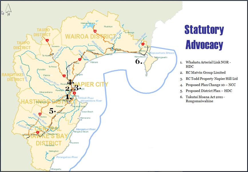
|
Statutory Advocacy Update
|
Attachment 2
|
Statutory Advocacy Update (as at 31 July 2014)
|
Received
|
TLA
|
Map Ref
|
Activity
|
Applicant/
Agency
|
Status
|
Current Situation
|
|
18 July 2014
|
HDC
|
1
|
Notice of
Requirement
A Notice of
Requirement for the Whakatu Arterial Link project to provide a road between
Havelock North, State Highway 2 North, Pakowhai Road, the Expressway and the Port of
Napier.
|
HDC
|
Notified
|
31
July 2014
· Submissions
close Wednesday 20th August 2014.
· Staff are
currently assessing the NOR.
· Details of
the application can be found here Notice of
Requirement
|
|
17 July 2014
|
NCC
|
2
|
Resource
Consent Application
Application
is to redevelop an ex-service station to establish a commercial activity
involving six retail tenancies at 83 Kennedy Road (corner of Kennedy Road and
Georges Drive).
|
Matvin Group
Limited
|
Notified
|
31
July 2014
· Submissions
close Friday 15 August 2014.
· Staff are
currently assessing the application in terms of contaminated soils, the
impacts of additional traffic flows and public transport.
· Details of
the application can be found here application
documents
|
|
11 July 2014
|
NCC
|
3
|
Resource
Consent Application
Proposed
residential development of a portion of the former Napier Hospital, Hospital
Terrace, Napier.
|
Todd Property
Napier Hill Limited
|
Notified
|
31
July 2014
· Submissions
close Friday 8 August 2014.
· Staff have
assessed the application having had particular regard to the intensification
of housing density, contaminated soils and the impacts of additional traffic
flows and are satisfied that no submission is required.
· Details of
the application can be found here application
documents.
|
|
5 December
2013
|
NCC
|
4
|
Plan Change
10 to the Operative City of Napier District Plan.
A community
driven Plan Change to harmonise district wide provisions between the Napier
District Plan with the Hastings District Plan, incorporate the Ahuriri
Subdistrict Plan and update provisions as a result of recent Napier City
Council policy changes and decisions into the Napier District Plan.
|
NCC
|
Notified,
hearing
pending
|
31
July 2014
· Further
submissions closed Friday 9 May 2014. HBRC staff did not consider that
a Further Submission was required as none of the Submissions received by NCC
contradicted HBRC’s original Submission or raised issues of concern to
this Council.
· In total NCC
received 28 Submissions. It is anticipated that NCC will begin hearings
within the next few months.
· Submissions
closed on Friday 14 February 2014. The HBRC submission can be found at HBRC
Submissions
· Previously
informal comments were made by staff on draft content relating to HPUDS and
RPS Change 4.
|
|
8 November
2013
|
HDC
|
5
|
Proposed
Hastings District Plan
Review of the
Hastings District Plan in its entirety. Includes the harmonisation of
district wide provisions between the Napier District Plan with the Hastings
District Plan where relevant.
|
HDC
|
Notified,
hearings in progress
|
31
July 2014
· HDC have
commenced hearings on topic by topic basis. HDC’s hearings
programme
scheduled to run through remainder of 2014.
· Further
submissions closed Friday 9 May 2014. HBRC lodged a Further Submission
on a number of Submissions including on those requesting development in areas
outside of HPUDS.
· In total HDC
received 198 Submissions on their Proposed District Plan. It is
anticipated that HDC will begin hearings within the next few months.
· The HBRC
Submission and Further Submission on the HDC Plan Review can be found here HBRC Submissions http://www.hbrc.govt.nz/HBRC-Documents/HBRC
Document Library/20140214 Submission HDC District Plan.pdf
· Prior to the
notification of the Proposed District Plan, HDC released a Draft District
Plan Review on which the Regional Council provided comments. Various
informal comments were made by staff on draft content, particularly relating
to natural hazards, HPUDS and RPS Change4, riparian management.
|
|
1 August 2013
|
NA
|
6
|
Application
under Coastal and Marine (Takutai Moana) Act 2011
Rongomaiwahine has made an
application for a Protected Customary Rights Order and a Customary Marine
Title Order in the general Mahia Peninsular area under section 100 of the
Marine and Coastal Area (Takutai Moana) Act 2011.
|
Rongomaiwahine
(Pauline Tangiora)
|
Notified
|
31
July 2014
· Council has
opposed the grant of the orders unless the nature and geographical extent of
the orders is specified with sufficient detail to enable the Council to
appropriately understand the effect of the orders sought.
· High Court
has been assessing validity of other parties joining these proceedings. No
additional actions or responses have been required from HBRC since joining
proceedings in late 2013.
|
HAWKE’S BAY REGIONAL COUNCIL
Environment
and Services Committee
Wednesday 13 August 2014
SUBJECT: Minor Items Not on the Agenda
Reason for Report
This document has been
prepared to assist Councillors note the Minor Items Not on the Agenda to be
discussed as determined earlier in Agenda Item 6.
|
Item
|
Topic
|
Councillor
/ Staff
|
|
1.
|
|
|
|
2.
|
|
|
|
3.
|
|
|
|
4.
|
|
|
|
5.
|
|
|