HAWKE’S BAY REGIONAL COUNCIL
Regional
Planning Committee
Wednesday 14 May 2014
SUBJECT: Tukituki Plan Change - Draft Board of Inquiry Decision
Reason for Report
1. The purpose of this
report is to brief the Committee on the Board of Inquiry’s draft decision on
the Tukituki Catchment Proposal and to outline the implications for the community
and for HBRC in terms of implementation.
2. The draft decision was
released on 15 April 2014 and with various appendices comprises three volumes.
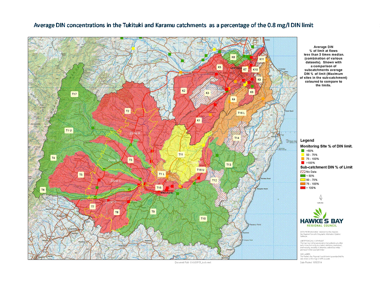
The decision itself is 348 pages. The process provides for the applicant and
submitters to comment on the decision in terms of errors, technical matters or
omissions. The last date for these detailed administrative and technical
comments is16 May 2014.
Background to the Tukituki Water Strategy
3. The Tukituki Catchment
Proposal, which included the Tukituki Catchment Plan Change 6 and the
Ruataniwha Water Storage Scheme resource consent applications, represented
HBRC’s strategic response to water quantity and water quality issues in the
Tukituki River Catchment.
4. Plan change 6 as
originally notified proposed to increase minimum flows, that is, the flow at
which water takes would be restricted or cease, to a level that provided a
better level of protection for aquatic habitat during low flow periods.
5. This would reduce the
security of water supply for farmers and horticulturalists and impact them
economically so HBRC investigated storage options as alternative supply.
6. Any storage
infrastructure needed to be financed through a commercial model which therefore
required development opportunities. Nevertheless, Plan Change 6 needed to stand
alone.
7. Plan Change 6’s
approach to nutrient management focussed on phosphorus mitigation to reduce
periphyton and manage nitrogen such that aquatic species were protected. This
allowed for farmers’ financial resources to be directed to where it would have
the most impact (actual P mitigation) and that the regulatory intervention is
directed to land use intensification over current land use.
8. Requirements for
nutrient budgets, stock exclusion, farm environmental management plans and
phosphorus management plans, bridging and culverting were targeted and staged
over time to take into account financial and capacity issues.
Summary of the Board’s draft decision
9. The Board endorsed the
increases in the minimum flow limits thus accepting the economic impacts on
consent holders. The Board also endorsed the agreed allocation limits for
surface water and groundwater.
10. It signalled that more
water could be made available from groundwater (referred to as Tranche 2) but
not at the expense of consent holders currently subject to the minimum flow
limits. Applicants would need to demonstrate a supplementary flow regime so
that existing consent holders and the river are not further affected.
11. The Board did not accept
HBRC’s nitrogen management approach and significant changes have been made to
policy and rules.
12. It determined that an
average Dissolved Inorganic Nitrogen concentration of 0.8 mg/l was
required to maintain ecological health as assessed by the MCI indicator (Macro-Invertebrate
Community Index). The Board imposed this as a limit over the whole of the
catchment, except for the headwaters, which were already set at 0.15 mg/l
being the equivalent of current water quality. Much of the catchment exceeds
0.8 mg/l concentration and therefore the catchment is automatically in an
‘over-allocated’ state. This is shown in Attachment 2.
13. It grants consent for
the RWSS tied to the 0.8 mg/l DIN limit, which if taken literally
effectively removes the ability of the RWSS to be a viable commercial model.
Therefore it also removes a significant potential source of reliable water
supply to offset increases in minimum flow limits.
14. The Board did not find
the proposed nitrogen cap for the catchment helpful and was concerned about the
significant increase it represented over the estimated current nitrogen load
for the catchment. Instead, it favoured using the Land Use Capability classes
as a proxy for a natural capital approach and set leaching rates for each
class.
15. The Board found that all
farms over 4 ha (except low intensity / lifestyle type blocks under
10 ha) should prepare farm environmental management plans by 2018 and
implement them by 2020.
16. While maintaining the
phosphorus management framework, the cost implications of the decision if
retained, will result in a diversion of resources (both farmer and Council)
away from managing phosphorus to managing nitrogen.
Impacts of Increased Regulation and
Stricter DIN limits
Farm Environmental Management Plans (FEMP)
17. There are 1062 farms in
the catchment over 4 ha in size. It is estimated that preparing a Farm
Environmental Management Plan that includes a Phosphorus Management Plan module
will cost between $3000 and $5,500 per farm. A realistic estimate of the total
cost to farmers for completing FEMPs on all 1062 farms is $4.5 million.
18. The FEMPs need to be
completed prior to 1 June 2018 in order for the farming to remain a permitted
activity. Staff estimate that an additional 12 qualified and experienced FEMP
practitioners need to be sourced immediately, and that workload spread over the
next 4 years.
19. This is unlikely to be
achievable in terms of both capacity and willingness of farmers to incur the
costs sooner than they need to. We estimate that some 600 farms would require
a resource consent for failing to complete an FEMP. Processing costs are shown
in Attachment 1 (scenario 2).
Where catchment exceeds 0.8 mg/l
20. A condition of the
permitted activity rule for use of production land is that after 1 June 2018,
it should not contribute to an exceedence of the nitrate and DIN limits. The
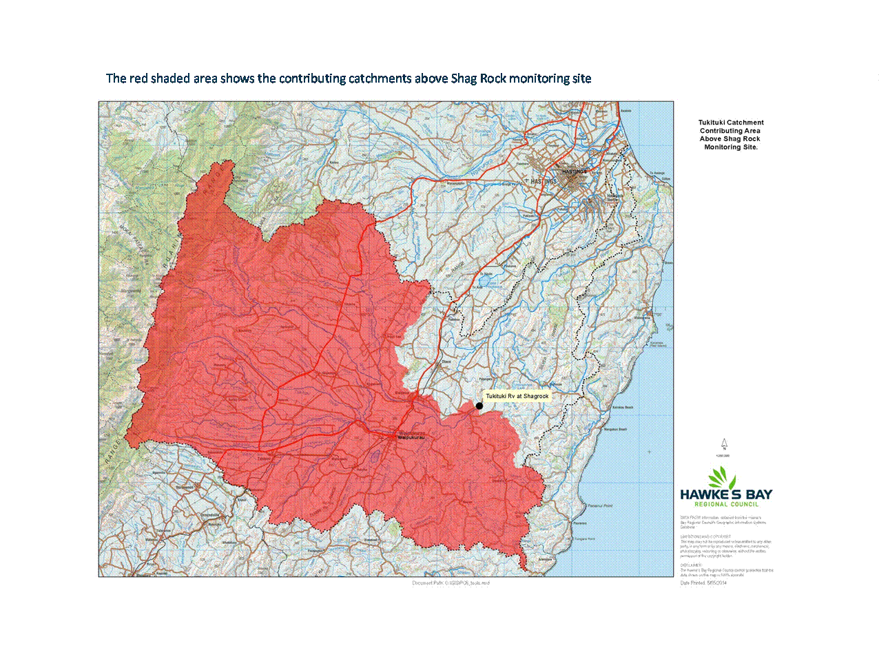
water quality in the Tukituki River at Shag Rock (below the confluence of the
Waipawa River and the Mangatarata Stream) already exceeds the 0.8 mg/l
level by 30%. The red shaded area in Attachment 3 shows the catchment area that
contributes to the water quality at the Shag Rock monitoring site.
21. There are estimated to
be 615 farms greater than 4 ha above that point. Modelling undertaken by
HBRC using TRIM shows that on average those farms will need to reduce their
existing leaching by 40% to meet the 0.8 mg/l limit.
22. Land uses such as
extensive sheep and beef have little capacity to reduce their nitrogen
footprint materially so costly mitigation and significant land use change will
be required in order to meet the 0.8 mg/l.
23. It is almost certain
that all 615 farms above Shag Rock will require land use consents come 1 June
2018. Processing costs are shown in Attachment 1 (scenario 1). These will be
complex applications to process as significant reductions in N losses will need
to be stipulated. It will be very difficult for the consent process to manage
that without guiding N reduction policies in the plan and no such guidance has
been given. The reason for this is perhaps because the Board of Inquiry did
not realise that its draft decision would have this effect.
Other reasons for consents
24. Attachment 1 shows a
number of other reasons why a consent would be required and the associated
costs. Many of these reasons might be addressed through one consent. However an
estimated number of consents in the order of 600-700 is considered to be
conservative.
25. Scenarios 4 and 5 relate
to farms which are unable to meet the LUC leaching rates. Exceeding the LUC
leaching rates by more than 10% is a non-complying activity which effectively
means there are significant thresholds to meet in order for a consent to be
granted. However, irrespective of meeting the LUC limits, if the DIN limit is
exceeded, LUC leaching rates will need to be reduced by around 40-45% on
average.
Economic and Financial Analysis
26. A provisional economic
analysis of the impact of the LUC leaching rates and the 0.8 mg/l DIN
limit has been undertaken by HBRC.
27. Preliminary calculations
have evaluated the top half of the Tukituki catchment area (above the Walker
Road monitoring site). This analysis indicates that the 0.8 mg/l DIN may
reduce current farm EBIT by more than $15 million per annum and require the
conversion of 6000 ha of productive land into forestry. There will be
significant additional capital costs associated with this transition.
28. A preliminary economic analysis
undertaken indicates that under the nutrient regulatory regime envisaged by the
Draft Decision, on farm regulatory costs will increase by more than $17 million
(NPV over the period 2014 – 2050).
29. The on farm EBIT losses associated with
increased minimum flow limits and the new DIN limits could translate into a $50
million ongoing loss in regional GDP (compared to the current situation).
30. The significant increase
in the number of consents required to be processed and monitored represents
significant implementation costs for the Council. Staff have estimated that an
additional 7 consent officers would be required over the 2018-2020 period
reducing to 2 additional consent officers on an ongoing basis. An additional
administration resource would also be required. Staff have estimated that an
additional 3 compliance officers may be required.
31. The Consent project
(Project 402) which covers processing as well as enquiries and advice is funded
through consent processing fees (charged to the applicant) and through general
funding including general rates. Overall the project is assessed as 60% private
good and 40% public good and is funded accordingly.
32. Similarly, the
Compliance project (Project 450) has a 70% private good and 30% public good
split.
33. The general funding
costs have been estimated to be in the order of $500,000 per year for the
2018-2020 to $230,000 ongoing.
34. Once the final decision
has been made, staff will bring a more comprehensive assessment of resource
requirements and delivery strategies as part of the Tukituki Plan Change
Implementation Plan.
Consultation with tangata whenua and
cultural issues
35. The adequacy of consultation
with tangata whenua was traversed at length throughout the hearing process by
Ngati Kahungunu Iwi Incorporated (NKII), the Heretaunga Taiwhenua and various
hapu.
36. With respect to NKII,
the Board reported that it “is satisfied on the evidence that the
consultation with NKII easily met the requirements of clause 3(1)(d) of the
First Schedule. It is also satisfied that HBRC can be treated as having
consulted with NKII by virtue of clause 3B of Schedule 1.”
37. With respect to
Heretaunga, the Board reported that it “is completely satisfied that over a
relatively lengthy period Heretaunga was involved in a consultation process
pursuant to clause 3(1)(d) of the First Schedule. We are also satisfied that
this process involved the tangata whenua of Heretaunga and that it was
appropriate in all the circumstances.”
38. The Board accepted the
new Policy TT16 which was developed between HBRC, NKII and the Heretaunga
parties, and acknowledged that it forms an important component of the cultural
dimension of Plan Change 6. It involves the development of a cultural mauri
monitoring framework for the Tukituki River Catchment but it is expected that
the development of the framework will be such that it will be applicable and
have buy-in across the region.
Decision Making
Process
39. Council is required to
make a decision in accordance with Part 6 Sub-Part 1, of the Local Government
Act 2002 (the Act). Staff have assessed the requirements contained within this
section of the Act in relation to this item and have concluded that, as this
report is for information only and no decision is to be made, the decision
making provisions of the Local Government Act 2002 do not apply.
|
Recommendation
That the
Regional Planning Committee receives the ‘Tukituki Plan Change Draft
Board of Inquiry Decision’ report.
|
|
Helen Codlin
Group
Manager
Strategic
Development
|
Liz Lambert
Chief
Executive
|
Attachment/s
|
1View
|
Reasons Why A
Resource Consent May Be Required
|
|
|
|
2View
|
Average DIN
concentrations in the Tukituki and Karamu catchments as a percentage of the
0.8 mg/l DIN limit
|
|
|
|
3View
|
Contributing
Catchments Above Shag Rock Monitoring Site
|
|
|
HAWKE’S BAY REGIONAL COUNCIL
Regional
Planning Committee
Wednesday 14 May 2014
SUBJECT: Karamu Characterisation Report
Reason for Report
1. This report, which has
been presented to the Environment and Services Committee on 9 April and
the Maori Committee on 29 April, and was compiled by our environmental
scientists to characterise the water quality, quantity and ecology of Karamu
streams including the groundwater aquifers of the Heretaunga Plains.
Karamu Characterisation Report
2. The report is
structured by sub-catchment, together with a synthesis of emerging patterns for
the broader catchment (Section 2), with data reported up to June 2011.
Establishing what we already know about the Karamu Catchment was an important
precursor to the more detailed investigations that are now under way for the
Greater Heretaunga plan change.
3. The Heretaunga Plains
represent one of the most productive horticultural areas in New Zealand. Water
resources in the Karamu Catchment have been developed for a variety of land
uses including orchards, crops, industry and town supply.
4. Groundwater is the
predominant water resource, with fewer resource consents for taking surface
water directly from streams (4,377,028 m³/wk groundwater allocation;
345,945 m³/wk surface water allocation as at May 2011). Water permit
records indicate a large increase in groundwater use through the 1980s.
5. The Heretaunga
groundwater aquifer is recharged, in part, by flow losses from the lower
Ngaruroro River. Springs arise at the transition between the unconfined and
confined aquifers, and these springs feed Karamu tributaries (e.g. Irongate
Stream, Raupare Stream). Some monitoring wells have experienced increased
seasonal variation in water levels. No change was detected in the long-term
winter groundwater level.
6. Water quality of the
Karamu may be categorised as degraded. A high proportion of nutrient results
(nitrogen and phosphorus) exceeded the recommended regional and national
guideline values for lowland rivers and streams.
7. The composition of
stream macroinvertebrate communities also indicates poor water quality. The
Macroinvertebrate Community Index scores for the Karamu catchment were among
the lowest observed in the Hawke’s Bay region. Results from eight sites had
very poor Macroinvertebrate Community Index scores (<60), including the
Awanui, Karewarewa, Poukawa, and Ruahapia. The sites with better MCI values
(closer to model predictions) included headwaters of the Raupare Stream,
Paritua Stream and Havelock North streams (Mangarau, Karituwhenua).
8. Most New Zealand
freshwater fish spend part of their life-cycle at sea. The proximity of the
Karamu sub-catchments to the sea maximises the number of species that should
have migratory access. A project to document potential barriers to fish passage
was initiated in 2008 and this located 31 structures in the Karamu catchment
that have the potential to restrict fish passage.
9. The Stream Ecological
Valuation method uses 31 variables to assess potential stressors of stream
life. Stressors identified by the SEV process at sites with very poor MCI
scores (e.g. Poukawa, Awanui, Karewarewa) included: elevated nutrient
concentrations, straightened channels, limited riparian shade, nuisance plant
proliferation, stock access and low flows. Riparian enhancement was predicted
to offer the greatest ecological benefit.
Decision Making
Process
10. Council is required to
make a decision in accordance with Part 6 Sub-Part 1, of the Local Government
Act 2002 (the Act). Staff have assessed the requirements contained within this
section of the Act in relation to this item and have concluded that, as this
report is for information only and no decision is to be made, the decision
making provisions of the Local Government Act 2002 do not apply.
|
Recommendation
1. That the
Regional Planning Committee receives the “Karamu Characterisation” report.
|
|
Thomas Wilding
Senior
Scientist
|
Stephen Swabey
Manager,
Science
|
|
Iain Maxwell
Group
Manager
Resource
Management
|
|
Attachment/s
There are no
attachments for this report.