Meeting of the Hawke's Bay Regional Council Maori
Committee
Date: Tuesday 25 February 2014
Time: 10.15 am
|
Venue:
|
Council Chamber
Hawke's Bay Regional Council
159 Dalton Street
NAPIER
|
Agenda
Item Subject Page
1. Welcome/Notices/Apologies
2. Conflict of Interest Declarations
3. Short Term Replacements
4. Confirmation of Minutes of the
Maori Committee held on 3 December 2013
5. Matters Arising from Minutes of the Maori Committee held
on 3 December 2013
6. Follow Ups from Previous Maori Committee Meetings
7. Call for any Minor Items Not on the Agenda
Decision Items
8. Submission to the Local Government Commission on the Draft
Proposal for HB Local Government Reorganisation
Information or Performance Monitoring
9. Update on Current Issues by the Interim Chief Executive
10. Greater Heretaunga Ahuriri Plan Change TANK Group Update
11. HB District Health Board "Healthy Homes"
presentation
12. The Establishment of Taiwhenua - verbal report by Dr Roger Maaka
13. Statutory Advocacy Update
14. Minor Items Not on the Agenda
Please Note - Pre Meeting for Māori Members of
the Committee begins at 9 am
HAWKE’S BAY REGIONAL COUNCIL
Maori
Committee
Tuesday 25 February 2014
SUBJECT: Short Term Replacements
REASON FOR REPORT:
1. Council has made
allowance in the terms of reference of the Committee for short term
replacements to be appointed to the Committee where the usual member/s cannot
stand.
|
RECOMMENDATION:
That the
Maori Committee agree:
That ______________ be appointed as member/s
of the Maori Committee of the Hawke’s Bay Regional Council for the meeting of
Tuesday, 25 February 2014 as short term replacements(s) on the Committee for
________________
|
|

Viv Moule
Human
Resources Manager
|

Liz Lambert
Chief
Executive
|
Attachment/s
There are no
attachments for this report.
HAWKE’S BAY REGIONAL COUNCIL
Maori
Committee
Tuesday 25 February 2014
SUBJECT: Follow Ups from Previous Maori
Committee Meetings
Introduction
1. Attachment
1 lists items raised at previous meetings that require actions or
follow-ups. All action items indicate who is responsible for each action, when
it is expected to be completed and a brief status comment. Once the items have
been completed and reported to Council they will be removed from the list.
Decision
Making Process
2. Council is required to make a decision in accordance with
Part 6 Sub-Part 1, of the Local Government Act 2002 (the Act). Staff have
assessed the requirements contained within this section of the Act in relation
to this item and have concluded that as this report is for information only and
no decision is required in terms of the Local Government Act’s provisions, the
decision making procedures set out in the Act do not apply.
|
Recommendation
1. That the Maori Committee receives the report “Follow
ups Items from Previous Maori Committee Meetings”.
|
|

Viv Moule
Human
Resources Manager
|

Liz Lambert
Chief
Executive
|
Attachment/s
|
Follow Up Items
|
Attachment 1
|
Follow Ups from Previous Maori Committee Meetings
3 December 2013 meeting
|
|
Agenda Item
|
Action
|
Person Responsible
|
Due Date
|
Status Comment
|
|
1.
|
Ngati Kahungunu Iwi
Incorporated Marine And Freshwater Fisheries Strategic Plan
|
Strategic Plan to be referred back
to Ngati Kahungunu for further consultation
|
MM/VM
|
Ongoing
|
Verbal update at 25 February Committee
meeting
|
|
2.
|
Update on Current Issues
|
Copy of Amalgamation
report to be circulated to Committee members
Copy of list of members
on TANK Stakeholder Group
|
MD
|
Following meeting
|
Completed and sent out with unconfirmed
mins
|
|
3.
|
Air Quality Monitoring Report
|
Heatsmart Update on DHB
findings
|
Vm/MH
|
23 February
|
Verbal report to be presented to 25
February meeting
|
HAWKE’S BAY REGIONAL COUNCIL
Maori
Committee
Tuesday 25 February 2014
SUBJECT: Call for any Minor Items Not on the Agenda
Reason for Report
1. Under standing orders,
SO 3.7.6:
“Where an item is not on the agenda for a
meeting,
(a) That item may be discussed at
that meeting if:
(i) that
item is a minor matter relating to the general business of the local authority;
and
(ii) the
presiding member explains at the beginning of the meeting, at a time when it is
open to the public, that the item will be discussed at the meeting; but
(b) No
resolution, decision, or recommendation may be made in respect of that item
except to refer that item to a subsequent meeting of the local authority for
further discussion.”
2. The Chairman will
request any items councillors wish to be added for discussion at today’s
meeting and these will be duly noted, if accepted by the Chairman, for
discussion as Agenda Item 16
|
Recommendations
That Maori
Committee accepts the following minor items not on the agenda, for discussion
as item 16.
1.
|
|

Leeanne Hooper
Governance
& Corporate Administration Manager
|

Liz Lambert
Chief
Executive
|
HAWKE’S BAY REGIONAL COUNCIL
Maori
Committee
Tuesday 25 February 2014
SUBJECT: Submission to the Local Government Commission on the Draft
Proposal for HB Local Government Reorganisation
Reason for Report
1. At its meeting on 18
December 2013 Council resolved to lodge a submission to the Local Government Commission
on its Draft Proposal for the reorganisation of local government in Hawke’s
Bay, based upon reinforcing the need for any local government structure within
Hawke’s Bay to have a specific focus on the management of natural resources in
recognition of the region’s strong linkages to its primary production sector.
2. A draft submission has
been considered by the Environment and Services Committee and changes suggested
at that meeting have been incorporated into the attached submission. The draft
submission has also been considered by the Regional Planning Committee and
their feedback will be provided verbal at the meeting. (Attachment 1) The
submission is being presented to Council on 26 February for final sign-off.
Feedback is sought from the Committee to ensure that any relevant points the
Committee wishes the Local Government Commission to address in its final
proposal are included in the submission.
3. Submissions close on 7
March 2014.
Decision Making
Process
4. Council is required to
make a decision in accordance with the requirements of the Local Government Act
2002 (the Act). Staff have assessed the requirements contained in Part 6 Sub
Part 1 of the Act in relation to this item and have concluded the following:
4.1. The decision does not
significantly alter the service provision or affect a strategic asset.
4.2. The use of the special
consultative procedure is not prescribed by legislation.
4.3. The decision does not
fall within the definition of Council’s policy on significance.
4.4. The persons affected by
this decision are all those persons with an interest in the delivery of local
government functions in Hawke’s Bay.
4.5. Options previously
considered by Council at its Corporate and Strategic Committee meeting 11
December 2013, and resolved at the Regional Council meeting 18 December
2013 included not lodging a submission.
4.6. The decision is not
inconsistent with an existing policy or plan.
4.7. Given the nature and
significance of the issue to be considered and decided, and also the persons
likely to be affected by, or have an interest in the decisions made, Council
can exercise its discretion and make a decision without consulting directly
with the community or others having an interest in the decision.
Notwithstanding this, any person may make a submission on the Local Government
Commission’s draft reorganisation proposal.
|
Recommendations
That the
Maori Committee:
1. Considers
the key points to be presented in the submission to the Local Government
Commission and provides feedback to assist in the
finalising of the submission.
The Maori
Committee recommends Council:
2. Agrees
that the decisions to be made are not significant under the criteria
contained in Council’s adopted policy on significance and that Council can
exercise its discretion under Sections 79(1)(a) and 82(3) of the Local
Government Act 2002 and make decisions on this issue without conferring
directly with the community and persons likely to be affected by or to have
an interest in the decision due to the nature and
significance of the issue to be considered and decided.
3. Approves
the submission, including any amendments agreed at the Maori Committee
meeting, for lodging with the Local Government Commission.
|
|

Liz Lambert
Chief
Executive
|
|
Attachment/s
|
1View
|
Updated Draft
Submission
|
|
|
|
Updated Draft Submission
|
Attachment 1
|
Draft
Submission
To: Local
Government Commission
Subject: Draft
Proposal for Local Government Reorganisation in Hawke’s Bay
Overview
The Hawke’s Bay
Regional Council (HBRC) welcomes the opportunity to submit on the Local Government
Commission’s draft proposal for local government reorganisation in Hawke’s Bay.
HBRC requests the
opportunity to be heard in support of its submission by the Commission.
HBRC seeks to
assist the Local Government Commission through its submission by noting a
number of matters which we consider should be given greater consideration by
the Commission in its decision making on whether or not to proceed to a final
proposal and, if so, what that final proposal should look like.
The Hawke’s Bay
Regional Council is the only local authority within the area affected by the
draft proposal that represents all the communities within that area. In our
view this allows the regional council to provide a greater level of
independence in respect of the communities of interest.
HBRC submitted an
Alternative Proposal for local government reorganisation when this was called
for by the Local Government Commission in March 2013. While the structure in
our alternative proposal by HBRC has not been accepted as a reasonably practicable
option our submission expresses concern that the principles outlined in that
alternative proposal, which are a fundamental of good local governance, have
not been addressed in any sense in the draft proposal.
The basic
contention of this submission is to provide solutions for the Commission to
consider in addressing these fundamentals of good local governance.
Rationale
The underlying
premise of HBRC’s submission is that form should follow function when it comes
to determining local government structure. In HBRC’s view the draft proposal
has not given adequate consideration of existing local government functions but
rather focuses on what local government might potentially do in a unitary
authority (noting that this is set out in the draft proposal without supporting
evidence).
A provincial
unitary council on the scale of Hawke’s Bay has not been contemplated before.
The current proposals for Northland are also of a smaller scale. Two thirds of
the new unitary Council’s population would be based in Napier and Hastings. Six
of the nine elected councillors will represent the Hastings and Napier wards.
Their interests and political mandates are likely to be influenced more by
urban than rural concerns, and more by matters of a territorial authority nature
than those of a regional council. With only ten politicians governing the
Hawke’s Bay Council, the distance between them and the community, particularly
in the rural area will increase. The specialist political representation and
knowledge of rural and natural resources is likely to be lost to a significant
degree.
Natural resource
knowledge and management, providing an integrated approach and specialist
expertise to natural resource management is a core function regional councils.
This is particularly essential to Hawke’s Bay given the region’s significant
natural resource base including large areas of land suitable for intensive
agriculture or horticulture and given that the region’s economy is driven by
primary production.
The
region needs to retain a core focus on ensuring the investment funds deliver
intergenerational work in the complex natural resource areas and the investment
capital is used for critical regional scale infrastructure which unlocks
sustainable economic opportunities. A dedicated focus on assisting the primary
sector to build resilience, and if possible to expand, also needs to be
retained in any future structure.
While it
is accepted that any regional council regulatory functions would need to
continue irrespective of structure the arguably more important contribution of
the regional council is in undertaking scientific investigations of natural
resources, particularly freshwater, and in adding value through the use of
investment capital for critical regional scale infrastructure which unlocks
sustainable economic opportunities.
Draft
Proposal
Key elements of the
draft proposal are:
· Amalgamation of current councils into
one unitary authority.
· Inclusion of small area of Rangitikei
district currently within Hawke’s Bay Regional Council into new council
· Exclusion of two areas of Taupo
district currently within Hawke’s Bay Regional Council from new council HOWEVER
the new Hawke’s Bay council would be responsible for regional council functions
in these areas (transferred from Bay of Plenty Regional Council)
· Nine councillors would be elected from
five wards. The Mayor would be elected at large
· The council would have five community
boards with 37 elected members.
· A standing council committee
comprising representatives of local iwi and elected members of council would
hear the views of Māori
· Existing council debt and financial
arrangements would be ring-fenced for at least six years to the communities
which incurred them or benefit from them. Current regional assets would be transferred
to Hawke’s Bay Council.
Commentary
Regional Council functions
The
regional council is particularly focussed on the issues of environmental
management, rural land use and primary production, and how this is linked to
the performance of the regional economy. This is built upon a focus on
freshwater management and soil/land management. The 2011 National Policy
Statement for Freshwater Management (NPS) means that regional councils are and
will be busy with a number of significant issues in its implementation,
including:
· Reviewing key planning documents in order to "give
effect to" the NPS
· Developing freshwater objectives and quality and
quantity limits
· Grappling with issues of "efficient
allocation", "efficient use" and water permit transfer criteria
· Reviewing discharge permit consent conditions
· Increasing the involvement of iwi and hapū and
improving the integrated management of fresh water.
This is leading to
considerable policy and plan development by regional councils over the next few
years on what are very contentious issues. The work required to underpin
the setting of limits is complex, quite sophisticated and is going to take the
best part of a decade to work through.
Of concern to HBRC
in the establishment of a unitary authority is the focus on territorial
authority activities. While this is understandable, and is not a criticism, it
does lead to questions around the ongoing financial sustainability of the
programmes required to be undertaken over long term periods to validate the
policies required to be developed, not just in the area of freshwater
management but in the management of other public resources such as air, land
and the coast.
In recognition of
the responsibilities placed on regional councils to manage the “commons” without
the ability to recover costs directly, regional councils were transferred
ownership of port companies in the 1989 New Zealand-wide local government
reorganisation. The Hawke’s Bay Regional Council relies on the dividend paid to
it annually by the Port of Napier Ltd to allow it to undertake scientific
investigations, environmental monitoring and land management activities that
would otherwise have to be funded directly by the ratepayer. HBRC’s concern is
that the funding of such activities is vulnerable to the more immediate needs
often associated with urban based council activities.
The tone of
regional council decisions is different to that of territorial authorities. Of
necessity regional councils generally takes a long-term strategic look at its decisions
as these involve long-term outcomes and significant, ongoing financial
resourcing. In that regard HBRC believes that the formation of an elected rural
and natural resources special purpose board with advisory and/or decision
making functions should also be completed by the Commission, so that specialist
governance input for regional council functions will be adequately provided to
a future Hawke’s Bay Council.
We request that the
dividend paid by the Port of Napier Ltd be “ring-fenced” for regional council
environmental management functions in the final proposal. It is the Regional
Council’s understanding that such “ring-fencing” can be undertaken in
perpetuity and is not limited by a six-year maximum term.
Hawke’s Bay
Regional Council seeks that any final proposal for local government
re-organisation in Hawke’s Bay that excludes the retention of a stand-alone
regional council includes provision for the ring-fencing of the dividend paid
to the local authority by the Port of Napier Ltd for expenditure on the
following functions:
· Environmental air
quality control
· Natural resource
environmental monitoring
· Biosecurity
· Harbourmaster
functions/navigation and safety
· Land management
· Regional resource
management planning
· Coastal planning
and management
· Freshwater science
investigations, including water allocation and water quality monitoring
· Stormwater and
wastewater regulations
Hawke’s Bay
Regional Council seeks that any final proposal for local government
re-organisation in Hawke’s Bay that excludes the retention of a stand-alone
regional council includes provision for the establishment of an elected Natural
Resources Board to provide specialist governance input for the regional council
functions of the Hawke’s Bay Council.
A stand-alone regional
council
The Draft Proposal
rejects the concept of one Hawke’s Bay District Council and one Hawke’s Bay
Regional Council on the basis that it would be seen as creating confusion in
the public mind as to who had political mandate to speak for Hawke’s Bay. No
other considerations that are required to be assessed by the Local Government
Commission are presented in the draft proposal in relation to this option e.g.
whether or not this option facilitates efficiencies and cost savings;
productivity improvements and simplified planning processes.
Amendments
to the Local Government Act in December 2012 mandate that any proposed
reorganisation must ‘promote good local government’ by facilitating:
· Efficiencies and cost savings;
· Productivity improvements, both within
the affected local authorities and for the businesses and households that
interact with those local authorities; and
· Simplified planning processes within
and across the district or region through, for example, the integration of
statutory plans or a reduction in the number of plans to be prepared or
approved by the local authority.
In addition any
proposed authority must –
· Have the resources necessary to enable
it to carry out effectively its responsibilities, duties and powers;
· Contain within its district or region
1 or more communities of interest, but only if they are distinct communities of
interest;
· Enable catchment-based flooding and
water management issues to be dealt with effectively by the unitary authority.
The legislation
does not specify that the issue of political mandate to speak for an area is a
criterion for the promotion of good local government. The draft proposal fails
to address the matters that the Local Government Act 2002 specifies must be
facilitated by any proposed reorganisation and therefore fails to give the
submitting public of Hawke’s Bay an opportunity to explore the rationale for
the rejection of a stand alone regional council.
Hawke’s Bay Regional
Council seeks that any final proposal for local government re-organisation in
Hawke’s Bay that excludes the retention of a stand-alone regional council
includes a detailed analysis of the rationale for the Local Government
Commission rejecting a stand- alone council in accordance with all the required
provisions of the Local Government Act 2002.
Community Boards
The effectiveness
of the “local voice” in the draft proposal relies to a large extent on the
existence of the community boards. The draft proposal notes that it may be
possible that the passing of local government legislation amendments will allow
for the provision of local boards in Hawke’s Bay.
A unitary authority
with community boards does not guarantee the effective representation of Hawke’s
Bay’s communities or the delivery of local services based on communities’
needs. The existence of community boards is subject to a six-yearly
representation review at which point the Hawke’s Bay Council could form a view
to abolish or reconstitute them. In addition the powers and duties of a
community board are largely determined by the governing body (the Hawke’s Bay
Council). Such a hierarchical model does not guarantee the sustained, strong,
localised governance needed in an area like Hawke’s Bay, nor does it enhance
the relationship of the ratepayer to the authority that sets its rates.
Should the required
legislation be passed to allow for local boards the Hawke’s Bay Regional
Council requests that the Local Government Commission, as provided for in
Clause 21 (1) C) of Schedule 3 of the Local Government Act 2002, identify
another preferred option as the basis of a new draft proposal. We do not
consider that the issuing of a modified draft proposal would be satisfactorily
transparent. The public of Hawke’s Bay need to be able to know what a local
board is and what it can do on their behalf, how it and its activities are
funded, and the extend of its decision making powers.
Hawke’s Bay
Regional Council seeks that a revised draft proposal be issued to enable public
submissions to be lodged in the event that the Local Government Commission
determines that it wishes to see the establishment of local boards for Hawke’s
Bay, should the requisite legislation be passed.
Māori representation
Underpinning
the people, the economy and the environment is the development of an
appropriate co-governance model. A resilient and sustainable planning
framework is coming out of the co-governance Regional Planning Committee of the
Hawke’s Bay Regional Council, which maintains equal numbers of iwi (represented
by mandated Treaty settlement groups) and elected regional representatives at
the table, debating and making recommendations for future natural resource
management. Through reforms to the Resource Management Act the Government is
seeking to ensure that Māori
interests and values are considered earlier in resource management planning
processes with solutions developed up-front.
The draft proposal
provides for the establishment of a standing committee to hear the views of
Māori. The Hawke’s Bay Regional Planning Committee, comprising equal
representation of elected representatives and mandated treaty groups, will be
in place legislatively by the time the Local Government Commission issues its
final proposal. HBRC considers it essential that the final proposal, or a new
draft proposal, includes clarification of the relationship between the Regional
Planning Committee roles and responsibilities and that of the standing
committee.
The Regional Planning Committee model, being
based upon Treaty settlement groups, ensures that all appropriate iwi are
represented at the decision-making table through their mandate. It also meets
their needs as part of their cultural redress sought through Treaty claims on
the management of natural resources.
Hawke’s Bay
Regional Council seeks that any final proposal for local government
re-organisation in Hawke’s Bay that excludes the retention of a stand-alone
regional council includes clarification around the roles and responsibilities
of the Māori Standing Committee and the legislated Regional Planning
Committee. This is important as while the Māori Standing Committee will
act in an advisory role only the Regional Planning Committee has a
co-governance role. The expectations arising these two separate arrangements
need to be made clearer to the public.
Taupo
The draft proposal
creates an unacceptable level of uncertainty around the exclusion of two areas
of Taupo district currently within the Hawke’s Bay Regional council area from
the new unitary authority. These two areas are in the headwaters of the Mohaka
River, Hawke’s Bay’s longest river. There is a small usually resident
population within these two areas (2011 est: 90) and the land is predominantly
high country indigenous bush and scrub, with the balance in forestry and
farming. The total area is around 78,500 ha.
It is clear that in
the draft proposal the Commission considers that community of interest has
primacy over catchment. It proposes that these areas remain with Taupo
district, and be included in the Bay of Plenty Regional Council area, but that
the regional council responsibilities in those two areas then be transferred to
the Hawke’s Bay Council under the final reorganisation scheme. No direction is
given in the draft proposal about how such activities would be funded and by
whom, whose resource management act provisions would apply and how any
differences could be resolved.
We note that:
· The LGC
noted that for the purposes of effective catchment management, two small areas
of Taupō district and one small area of Rangitikei district are presently
included in Hawke’s Bay region. Following discussion with Hawkes Bay Regional
Council (HBRC) officers, the LGC concluded that it would be important for these
areas to remain under the authority of any new Hawke’s Bay unitary authority,
at least for catchment and related purposes (Clause 175).
· The LGC
noted that the two small areas of Taupō district were in Hawke’s Bay
region, in order that the Mohaka River catchments were contained within the
boundaries of one regional council, i.e. HBRC. The LGC considered that it was
important that these catchments were not divided, given the national
significance of the river which has a conservation order on it, and which has
been the subject of a Waitangi Tribunal recommendation relating to interests of
Ngāti Pahauwera (Clause 177).
· On the
other hand, the LGC received correspondence from Taupō District Council
opposing the separation of these two areas from Taupō district, on
community of interest grounds (Clause 178). The LGC agreed there were strong
community of interest arguments for these areas to be kept within the
boundaries of Taupō district and also that this was likely to be supported
by Ngāti Tūwharetoa (Clause 179).
· In order to meet the conflicting
arguments, the LGC concluded that if one unitary authority were to be
established for Hawke’s Bay, the two areas of Taupō district should be
excluded from the new district but that responsibility for the regional council
functions presently being undertaken by HBRC, should continue to be the
responsibility of the new Hawke’s Bay unitary authority. This would involve
including these areas in the Bay of Plenty region and transferring the regional
council statutory obligations for these areas to the new Council under Section
24(1)(e) of the LGA (Clause 180).
Specifically, we are unclear how the transfer of statutory
obligations from BOPRC to the Hawke’s Bay Council would work in practice and
seek clarification on this matter, including but not limited to:
· Funding
- how the delivery of functions and services would be funded, including how
rating would work practically. Our understanding is that rating functions
cannot be transferred to another authority, so BOPRC would of necessity be the
rating authority for these areas.
· Governance
arrangements – how representation of residents and ratepayers for regional
council functions would operate, i.e. which Council(s) residents would vote
for, in terms of regional council functions, and whether this would be the same
Council that is delivering regional council functions and services in their
area.
· Resource
Management Act – how roles and responsibilities under this Act would operate
without creating inconsistencies and uncertainty. For example, if the two areas
in question were to be covered by the Bay of Plenty Regional Policy Statement
(which is currently based on entire catchments) and Bay of Plenty regional
plans, while resource consenting and regulatory roles were transferred to the
Hawke’s Bay Council.
Hawke’s Bay Regional Council seeks that any final proposal for
local government re-organisation in Hawke’s Bay clarifies the transfer of
statutory obligations from the Bay of Plenty Regional Council to the Hawke’s
Bay Council. It is extremely difficult for HBRC to determine a position of
support for this aspect of the proposal until these points of clarification
have been provided.
Further analysis
In our view the
draft proposal issued by the Local Government Commission in November 2013 is
inadequate in terms of detail. Before the Local Government Commission issues a
final proposal, or a new draft proposal, it must do much more analysis of the
current functions and responsibilities of the councils, the number of FTEs
associated with performing those functions and the costs of transition and
integration.
Robust data and
evidence must be provided in support of the preferred option so that the public
can understand what the true costs and benefits of the options are.
Much has been made
of the costs and benefits of the creation of the Auckland super-city, with
almost as many different accounts put forward as there are commentators. It
would be of huge assistance to the people of Hawke’s Bay to have an assessment
of the costs and benefits of the preferred option provided by the Commission to
assist them make up their minds.
Hawke’s Bay
Regional Council requests that if the Commission determines that local boards
are to be included in the local government structure in Hawke’s Bay, and
include these in a re-issued draft proposal, it is critical that the cost and
resources associated with local board plans and agreements and the
administration and support services associated with them are quantified.
Transition arrangements
There is very
little detail about the transition phase in the draft proposal and particularly
about the resourcing requirements that may be required from councils. Given
that HBRC operates in as lean and efficient way as possible this is a potential
concern impacting on council functions during transition and the maintenance of
current levels of service to Hawke’s Bay.
Hawke’s Bay
Regional Council seeks that any final proposal for local government
re-organisation in Hawke’s Bay that excludes the retention of a stand-alone
regional council includes detail on the transition phase in order to understand
what impacts this phase might have.
The draft proposal proposes that the Hawke’s Bay Council’s
administrative headquarters would initially be located in Napier City. However
if the transition board decides there is a more appropriate location it would
make a recommendation to the new council on the future location of the
headquarters. In our view the transition board should not be concerning itself
with a recommendation to the new council on the future location of the
headquarters. The transition period is brief enough as it is and it seems
inefficient and not cost effective to establish the body in one location and
potentially move it quickly to another. The new Council should have a period of
bedding in and aligning a range of existing organisations into one body before
considering the location of its headquarters.
Hawke’s Bay Regional Council seeks that any final proposal for
local government re-organisation in Hawke’s Bay specifies the location of the
council headquarters and service centres for a period of five years and removes
responsibility for making a recommendation on this from the Transition Board.
This time period is in line with the Commission’s proposal that Council
services would continue to be provided for at least five years at service
centres in existing council locations in Wairoa, Napier, Hastings, Waipawa and
Waipukurau. This would allow for a comprehensive review of all physical
locations of Council services at that time.
Conclusion
Hawke’s Bay
Regional Council is of the view that the draft proposal for local government
reorganisation in Hawke’s Bay does not provide sufficient certainty for the
ongoing resourcing and prioritisation of natural resource management functions in
Hawke’s Bay. This is critical for the ongoing economic development prospects of
the region. It would be helpful for the Local Government Commission to give
further consideration to a number of matters raised in our submission and we
are willing to provide assistance in this if asked.
Given the concerns
we have raised we are unable to support the draft proposal for Local Government
Reorganisation in Hawke’s Bay in its present form.
HAWKE’S BAY REGIONAL COUNCIL
Maori
Committee
Tuesday 25 February 2014
SUBJECT: Greater Heretaunga Ahuriri Plan Change TANK Group Update
Reason for Report
1. This paper provides an update on the
TANK collaborative stakeholder group which is deliberating policies for the
Greater Heretaunga and Ahuriri Plan Change. The TANK Group has published a
report summarising its work to date which is attached to this paper.
2. This update is similar
to a report presented to the Regional Planning Committee meeting on 19
February. Due to timing of that meeting and production deadlines for the Maori
Committee meeting agenda, timing did not allow this paper to record the
outcomes of the Regional Planning Committee’s discussion. At the Maori
Committee meeting, staff will present (any) recommendations made by the
Regional Planning Committee on this TANK project update.
Background
The TANK Group
3. The TANK Group was
convened in October 2012 to discuss land and water management options for the
Tutaekuri, Ahuriri, Ngaruroro and Karamu (TANK) catchments (surface and ground
water). Collectively this area is referred to as Greater Heretaunga and
Ahuriri.
4. The TANK Group is
comprised of 30 people from a range of backgrounds. The TANK Group’s brief is
to provide Council (via the Regional Planning Committee) consensus
recommendations regarding objectives, policies, limits and rules for a plan
change to the RRMP for the Greater Heretaunga and Ahuriri catchment area.
5. As well as making
recommendations on values and overall objectives, there are a number of key
regional planning provisions that the TANK Group is tasked with making
recommendations to Council on. These include:
5.1. flow regime, including low flow
restrictions on takes
5.2. water allocation (including for
municipal and domestic supply)
5.3. security of water supply for water
users
5.4. policies, rules on groundwater
/surface water connectivity
5.5. surface water and groundwater quality
limits
5.6. tangata whenua involvement in
freshwater decision making
5.7. use of Mātauranga Māori in
monitoring and reporting
5.8. wahi tapu register
5.9. policies, rules and incentives on:
5.9.1. riparian management and stock exclusion
5.9.2. water storage
5.9.3. water efficiency
5.9.4. water sharing/transfer
5.9.5. nutrient loss/allocation
5.9.6. good irrigation practices
5.9.7. stormwater management
5.9.8. other agricultural practices.
6. The Group was initially
scheduled to hold seven meetings through to July 2013 but due to the Plan
Change timeframe extension (adopted in the 2013/14 Annual Plan process), the
Group’s schedule was also extended. The Group has now held 11 meetings, the
most recent being on 10 December 2013. This makes parts of the Group’s existing
Terms of Reference obsolete meaning that this will be revised and updated.
The TANK Report
7. At the 10 December TANK
Group meeting, the Group approved its first report for public release. The TANK Interim Report summarises the TANK Group’s work
between October 2012 and December 2013 and provides a platform for the group to
proceed with future discussions. The Report was the result of extensive
discussion amongst the group over a series of meetings as well as
communications with the group’s networks over a three month period between
September and December 2013.
8. The
TANK Report is not a Council report; rather it is the TANK Group’s report
presented to Council and to be available to the wider public. It includes a set
of ‘Interim Agreements’ which are “supported in principle” by most (but not
all) parties on the Group, including the Regional Council (the Council being a
stakeholder).
9. The
TANK Report was intended to be publicly released in early January, however in
late December, Ngāti Kahungunu Iwi Incorporated (NKII) expressed
that they had a number of significant concerns and would not be endorsing the
Report. Due to commitments associated with the Tukituki Board of Inquiry
hearing, NKII noted that they would not be able to outline their specific
concerns with the TANK Report until that hearing had concluded.
10. Given that the TANK Group had undertaken
significant effort over three months to get the Report to a form suitable for
public release, a short-term resolution to the matter was to add a ‘Report
Status’ section to record NKII’s concerns. Earlier concerns that had been
raised by Hastings District Council and Matahiwi Marae were relocated to this
new section from footnotes. As noted in
the Report, these concerns will be the subject of discussion when the TANK
Group reconvenes.
TANK Group and Ahuriri
11. At the Council meeting
on 28 November 2013, Council committed to engaging with Mana Ahuriri, the Crown
and other parties in the formation and function of the Ahuriri Estuary
Committee (AEC). An Agreement in Principle was signed that includes addressing
the needs of Mana Ahuriri to have a joint management regime for the Ahuriri
Estuary.
12. Also on 28 November, Tim
Sharp from Council’s Strategic Development Group, met Mana Ahuriri Iwi Inc
Board to discuss the TANK Group and TANK Report. It was noted that any outcomes
of the TANK process will need to be consistent with AEC. To achieve this most
effectively, it may be pertinent that a member of the AEC be nominated to the
TANK Group.
TANK Group next steps
13. The intention is for the Group to
continue to meet through to, and during, the drafting of the Plan Change. There
is still a lot of ground to cover before the Group will be in a position to
make well-informed decisions about the form and contents of the Plan Change.
There is a wide range of science, cultural and economic information necessary
to be provided to the TANK Group to assist their decisions. Much of this work
is still to be done.
14. In the immediate future, a number of
approaches are currently under consideration for the TANK Group to proceed
including:
14.1. exploring the TANK Report ‘matters of
concern’ which have been raised by some parties
14.2. reviewing and summarising
catchment-specific issues identified to date to hone in the areas the TANK
Group needs to focus on
14.3. reviewing the Tukituki Plan Change to
see which approaches and provisions may be transferable into Greater Heretaunga
and Ahuriri
14.4. applying the National Objectives
Framework (NOF) to waterways in the Greater Heretaunga and Ahuriri area to
determine whether preferred waterway ‘states’ (as described in the NOF) can be
agreed by TANK members. However, the NOF is only proposed at this stage and
hence it may be too early for the TANK Group to consider.
15. To progress the discussions efficiently,
it is intended that smaller groups will meet to discuss different topics (e.g.
catchment-specific matters which may not impact on the full Group). The full
Group is likely to meet every three months to review the findings of these
smaller groups.
16. It is recognised that the Tukituki BOI
process has required the significant commitment of resources from many parties,
many of whom are also involved with TANK (as well as other Council projects
including the Taharua/Mohaka Plan Change). To provide a bit of breathing space,
the TANK process has rescheduled its next meeting from early March to
mid-April. This timing means the next meeting will be held after the Tukituki
BOI draft decisions are made.
Tangata whenua
representation on the TANK Group
17. Some of the issues
arising through the BOI hearing on the Tukituki Catchment Plan Change 6
regarding tangata whenua consultation have highlighted the importance of
getting the tangata whenua representation on the TANK Group right.
18. In the formation of the
TANK Group, tangata whenua groups were invited to nominate a member to the TANK
Group to ensure a broad cross-section of interests from a range of hapu,
taiwhenua and iwi was represented. Tangata whenua members on the TANK Group are
currently: Terry Wilson (Mana Ahuriri Iwi Incorporated);
Ngaio Tiuka (Ngāti Kahungunu Iwi Incorporated); Marei Apatu (Te
Taiwhenua ō Heretaunga); Morry Black (Matahiwi Marae); Peter Paku
(Ruahapia Marae); Jenny Mauger (Ngā Kaitiaki ō te Awa a Ngaruroro); Aki
Paipper (Ngāti Hori ki Kohupātiki); and Joella Brown (Te Roopu
Kaitiaki ō to Wai Māori).
Decision Making
Process
19. Council is required to
make a decision in accordance with Part 6 Sub-Part 1, of the Local Government
Act 2002 (the Act). Staff have assessed the requirements contained within this
section of the Act in relation to this item and have concluded that, as this
report is for information only and no decision is to be made, the decision
making provisions of the Local Government Act 2002 do not apply.
|
Recommendation
That the Māori
Committee receives the report titled ‘Greater Heretaunga Ahuriri Plan
Change TANK Group Update.’
|
|

Tim Sharp
Strategic
Policy Advisor
|

Gavin Ide
Manager,
Strategy and Policy
|
|

Helen Codlin
Group
Manager
Strategic
Development
|
|
Attachment/s
Collaborative decision making for
freshwater resources in the
Greater Heretaunga and Ahuriri Region
TANK Group Report 1
Interim Agreements
|
|

|
|
Naku te rourou nau te rourou ka ora
ai te iwi
With
your basket and my basket the people will live
|
HBRC
Plan No.
Status
of this Report
This Interim Report summarises the TANK Collaborative Stakeholder
Group’s work between October 2012 and December 2013 and provides a platform for
the group to proceed with future discussions. It includes a set of ‘Interim
Agreements’ which are “supported in principle” by most parties but not all. It
is anticipated the areas of disagreement will be resolved as the TANK Group
continues its collaborative process in 2014. The following parties have
expressed their positions on this report:
· Due to the local
body election process, the Hastings District Council has expressed the need for
further time to consider this report and intends to provide feedback to the
TANK Group as soon as practicable in 2014. However, no obvious or significant
issues have been identified based on initial consideration.
· Matahiwi Marae has
raised a number of concerns with specific aspects of this report. These
specific concerns are noted in the report by way of footnote.
· Ngāti
Kahungunu Iwi Incorporated do not endorse this report as there are a number of
matters that they are not in agreement with, some of which are significant.
These concerns will be raised in future TANK Group discussions with the aim of
resolving them.
TANK Group comment
As
a group of individuals representing a range of sectors, we appreciate the
opportunity to work together to manage our most precious resource – water. We
come from different backgrounds and represent different interests, but
collectively as the TANK Group we have the same goal:
“To enable present and future generations to gain
the greatest social, economic, recreational and cultural benefits from our
water resources within an environmentally sustainable framework.”
Most
of the things we value have a connection with water: the environment, economy,
our cultural identity and general health and wellbeing. To ensure that these
values continue to be supported we have to work together. The
collaborative process obliges us to listen carefully to one another, to learn
from what we hear, and to find ways of reconciling our interests.
We
recognise that the entire community’s interests are at stake and we owe
thanks to our networks who have entrusted us to provide a sound and strong
voice. We
will continue to seek their feedback to make sure that we are effectively and
appropriately representing their aspirations.
We
realise the importance of our task. The Greater Heretaunga and Ahuriri region
is both the economic hub of Hawke’s Bay and the place where many of us choose
to live. Yet some
of our waterways are in a degraded state and the risk to our futures of water
shortages is very real – as the 2013 drought showed.
Not
only do we need water to live and prosper, but our waterways are essential to
our very existence. The proverb Ko au te awa ko te awa ko au / I am the
river and the river is me resonates with us all. Water is a taonga and
collectively we see ourselves as being entrusted to protect our waterways and
to use water efficiently to ensure that current and future generation’s aspirations
are met.
This
First Report summarises our work to date and includes some
important agreements we have come to. Over the last twelve months we have
learned a great deal about the complexities of water management and we have
enjoyed working together to unravel the complexities. We have embraced this
challenge and we look forward to continuing to working together to ensure our
water and waterways are protected – now and in the future.
Table 1. The TANK Collaborative Stakeholder Group
|
Aki Paipper
|
Ngāti
Hori ki Kohupātiki
|
|
Brett Gilmore
|
Hawke’s
Bay Forestry Group
|
|
Bruce Mackay
|
Heinz-Wattie’s
|
|
David Carlton
|
Department
of Conservation
|
|
Christine Scott
|
HBRC
Councillor
|
|
Dianne Vesty / Leon Stallard
|
Hawke’s
Bay Fruitgrowers’ Association
|
|
Hugh Ritchie
|
Federated
Farmers
|
|
Ivan Knauf
|
Dairy
sector
|
|
Jenny Mauger
|
Ngā
Kaitiaki ō te Awa a Ngaruroro
|
|
Jerf van Beek
|
Twyford
Irrigators Group
|
|
Johan Ehlers
|
Napier
City Council
|
|
John Cheyne
|
Te
Taiao Hawke’s Bay Environment Forum
|
|
Marei Apatu
|
Te
Taiwhenua o Heretaunga
|
|
Mark Clews
|
Hastings
District Council
|
|
Mike Glazebrook
|
Ngaruroro
Water Users Group
|
|
Mike Butcher
|
Pipfruit
New Zealand
|
|
Morry Black
|
Matahiwi
Marae
|
|
Joella Brown
|
Te
Roopu Kaitiaki ō te Wai Māori
|
|
Neil Eagles
|
Royal
Forest and Bird Protection Society (Napier)
|
|
Ngaio Tiuka
|
Ngāti
Kahungunu Iwi Incorporated
|
|
Nicholas Jones
|
Hawke’s
Bay District Health Board
|
|
Peter McIntosh / Tim Hopley
|
Fish
and Game Hawke's Bay
|
|
Peter Paku
|
Mana
Whenua Ruahapia
|
|
Peter Beaven
|
HBRC
Councillor
|
|
Phil Holden
|
Gimblett
Gravel Winegrowers
|
|
Scott Lawson
|
Hawke’s
Bay Vegetable Growers
|
|
Terry Wilson / Wayne Ormsby
|
Mana
Ahuriri Iwi Incorporated
|
|
Tim Sharp
|
Hawke’s
Bay Regional Council
|
|
Tom Belford
|
HBRC
Councillor
|
|
Vaughan Cooper
|
Royal
Forest and Bird Protection Society (Hastings)
|
|
Xan Harding
|
Hawke’s
Bay Winegrowers
|
The TANK Group acknowledges the contributions of Adele Whyte, Dale
Moffatt,
Eileen von Dadelszen, Murray Douglas, Neil Kirton and
Nikola Bass who were previous members of the group.
The Group also acknowledges the support provided by researchers in
the Values, Monitoring and Outcomes Programme: Jim Sinner (Cawthron Institute),
Suzie Greenhalgh (Landcare Research), Natasha Berkett (Cawthron Institute),
Nick Craddock-Henry (Landcare Research) and Richard Storey (National Institute
for Water and Atmospheric Research) and the facilitation of Robyn Wynne-Lewis
(Core Consulting).
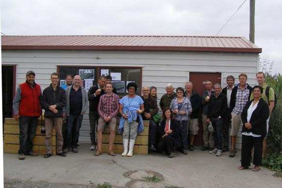
Figure 1: TANK Group field trip, February 2013
Table of Contents
TANK
Group comment v
1. Executive
Summary. 1
TANK Group Interim
Agreements. 3
Regional Plan
Changes. 3
Tangata whenua and
Mana whenua. 3
Values. 4
Minimum flows. 4
Water allocation. 4
Groundwater. 4
Good irrigation
practices. 5
Municipal water use
efficiency – interim agreements. 5
Global consents and
water sharing. 5
Staged reductions. 5
Water storage. 6
Nutrient management. 6
Stock exclusion. 6
Stormwater. 7
Wetland management. 7
Estuarine
management. 7
Tūtaekuri 7
Ahuriri 8
Ngaruroro. 8
Karamū. 8
2. Introduction. 10
3. Context 13
Resource Management
Act. 13
National Policy
Statement on Freshwater Management. 13
National
Environmental Standard for Sources of Human Drinking Water. 14
Hawke's Bay Land
and Water Management Strategy. 14
Regional Resource
Management Plan (including Regional Policy Statement) 14
Regional Plan
Changes – interim agreement. 16
4. The
TANK Collaborative Stakeholder Group. 16
5. Tangata
whenua and Mana whenua. 18
Tangata whenua and
Mana whenua - TANK Group Interim Agreements. 19
6. The
TANK Group decision making process. 21
7. TANK
Group Values, Objectives, Performance Measures and Management Variables. 25
Values. 25
Values – interim
agreements. 27
Objectives. 27
Performance
measures. 27
Management Variables. 29
8. TANK
region-wide topics. 30
8.1. Minimum
flows. 31
Minimum flows –
interim agreements. 32
8.2. Water
allocation. 32
Water allocation –
interim agreements. 33
8.3. Groundwater
investigations. 33
Groundwater –
interim agreements. 36
8.4. Measures
for improving water use efficiency. 36
8.4.1. Municipal
water use efficiency. 36
Municipal water use
efficiency – interim agreements. 37
8.4.2. Good
irrigation practices. 37
Good irrigation
practices – interim agreements. 37
8.4.3. Global
consents and water sharing. 38
Global consents and
water sharing – interim agreements. 39
8.4.4. Staged
reductions. 39
Staged reductions –
interim agreements. 42
8.5. Water
storage. 42
Water storage –
interim agreements. 43
8.6. Nutrient
Management 43
Nutrient management
– interim agreements. 44
8.7. Stock
exclusion. 44
Stock exclusion –
interim agreements. 45
8.8. Stormwater
management 45
Stormwater –
interim agreements. 47
8.9. Wetland
management 47
Wetland management
– interim agreements. 48
8.10. Estuarine
management 49
Estuarine management
– interim agreements. 49
9. Catchment
specific topics. 49
9.1. Tūtaekuri 50
Water quality. 52
Water quantity. 52
Tūtaekuri –
interim agreements. 53
9.2. Ahuriri 53
Water quality. 54
Water quantity. 55
Ahuriri – interim
agreements. 56
9.3. Ngaruroro. 56
Water quality. 58
Water quantity. 59
Ngaruroro – interim
agreements. 60
9.4. Karamū. 60
Water quality. 62
Water quantity. 63
Karamū –
interim agreements. 65
10. APPENDICES. 66
10.1. Management
Variables. 66
10.2. Glossary. 68
10.3. Key
documents and technical reports. 70
Coast and Estuaries. 70
Groundwater. 70
Hydrology. 71
Policy and Planning. 71
Tangata whenua and
Mana whenua. 71
Values. 72
Water Quality and
Ecology. 72
Tables and Figures
Table 1.
The TANK Collaborative Stakeholder Group. iv
Table 2:
Hypothetical example of the decision making process. 22
Table 3:
Hypothetical examples of the consequences of different Policy Options. 23
Table 4:
Values, Objectives and Performance Measures identified by the TANK Group's. 30
Figure
1: TANK Group field trip, February 2013. v
Figure
2: Plan Change Timeline. 2
Figure 3
Greater Heretaunga and Ahuriri Catchments. 12
Figure
4: Mike Glazebrook talking to the TANK Group at Te Tua Station; Field trip,
February 2013. 17
Figure
5: Marae locations. 20
Figure
6: Developing an influence diagram.. 25
Figure 7:
Example of an influence diagram (NB: this is not a complete influence diagram) 26
Figure
8: TANK Group discussions, October 2013. 27
Figure
9: Field trip to the Ngaruroro River, February 2013. 32
Figure
10: Groundwater takes in Greater Heretaunga and Ahuriri 36
Figure
11: Good irrigation practices are a necessity in gravel-dominated soils like
the Gimblett Gravels; Field trip, February 2013. 40
Figure
12: Theoretical staged reduction regime. 43
Figure
13: The TANK Group supports the preservation of Wetlands. 50
Figure
14: Marei Apatu describing mana whenua connections with the Ngaruroro River;
Field trip, February 2013. 60
Figure
15: Aki Paipper discussing improvement measures being undertaken at Kohupātiki;
Field trip, February 2013. 63
Figure
16: Consented water takes in the Karamū catchment 66
Abbreviations used in this report
RMA Resource
Management Act 1991
NPSFM National
Policy Statement for Freshwater Management 2011
LAWF Land
and Water Forum
HBRC Hawke’s
Bay Regional Council
RRMP Regional
Resource Management Plan
RPS Regional
Policy Statement
LAWMS Land
and Water Management Strategy
TANK Tūtaekuri,
Ahuriri, Ngaruroro, and Karamū catchments, or collectively the Greater
Heretaunga and Ahuriri area
TANK Group The
Greater Heretaunga and Ahuriri (TANK) Collaborative Stakeholder Group
1. Executive Summary
Hawke’s
Bay Regional Council (HBRC) is undertaking a change to the Regional Resource
Management Plan (RRMP) with respect to water management for the Tūtaekuri, Ahuriri, Ngaruroro
and Karamū catchments. The Greater Heretaunga and Ahuriri Plan
Change will seek to implement the Hawke’s Bay Land and Water Management
Strategy and the National Policy Statement for Freshwater Management and will
address specific water allocation and water quality issues in the four
catchments, including for wetlands and estuaries.
Council is
working with a collaborative stakeholder group to determine how these water
bodies should be managed. The TANK Group (named after the four catchments)
comprises 30 Hawke’s Bay representatives from agricultural and
horticultural sectors, tangata whenua, environmental and community interest
groups, and government agencies. HBRC has given a good faith commitment
to support any consensus recommendations from the TANK Group and to ensure the
Plan Change is consistent with the Group’s recommendations.
The key
aspects of the Plan Change that the TANK Group is tasked with making
recommendations to Council on are:
· Flow regime,
including low flow restrictions on takes
· Water allocation
(including for municipal and domestic supply)
· Security of water
supply for water users
· Policies, rules on
groundwater /surface water connectivity
· Surface water and
groundwater quality limits
· Tangata whenua involvement
in freshwater decision making
· Use of
Mātauranga Māori in monitoring and reporting
· Wahi tapu register
· Policies, rules and
incentives on:
o riparian management
& stock exclusion
o water storage
o water efficiency
o water
sharing/transfer
o nutrient
loss/allocation
o good irrigation
practices
o stormwater
management
o other agricultural
practices
This report
summarises the
TANK Group’s work
between October 2012 and December 2013 and includes the Group’s provisional
agreements listed below. The timeline for the Plan Change is outlined in Figure
2.
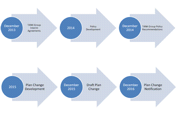
Figure 2: Plan Change Timeline
TANK Group Interim Agreements
The following
Interim Agreements are supported ‘in principle’ by the TANK Group and most of
their wider networks.[1]
The Interim Agreements provide a platform for the TANK Group to proceed with
further discussions and problem solving. For background and context around
these agreements please refer to the detail in the body of the report. Many of
the agreements are related to ‘next steps’ – and will be further developed by
the group through 2014 and beyond as technical information becomes available
and the Plan Change is drafted.
Regional Plan
Changes
1. The TANK
Group will review the Tukituki Plan Change once it is completed and consider whether
to use the same approaches where the same issues arise in the Greater
Heretaunga and Ahuriri Plan Change so that, where appropriate, the RRMP is
consistent across catchments.
Tangata whenua
and Mana whenua
2. The
TANK Group recognises the following:
a. That
the relationship between tangata whenua and freshwater is longstanding and
fundamental to their culture
b. That
water is valued by tangata whenua as a taonga of paramount importance
c. That
kaitiaki have obligations to protect and enhance the mauri of water and the
associated environment
d. That
tangata whenua have an obligation to be involved in freshwater decision-making
e. That
the relationship between tangata whenua and mana whenua and their wāhi
tapu, wāhi taonga and other taonga must be protected.
f. Ngāti Kahungunu whānau, hapū and
iwi have rights and interests in freshwater that extend beyond the “cultural”
space. While this has been discussed, exactly how this might manifest remains
uncertain.[2]
Values
3. The
TANK group will use the values identified in each of the catchments to assess
the consequences of policy options and seek to identify options that provide
for each of these values.
4. The
TANK group will recognise spatial variation of catchments and their values in
the limit-setting process, by setting objectives and limits for sites and
reaches within catchments where appropriate.
Minimum flows
5. Minimum
flow setting needs to take into account the impacts on environmental, cultural,
social and economic values using a variety of methodologies (e.g.
Mātauranga Māori; economic models).
6. The
TANK Group supports the use of RHYHABSIM for minimum flow setting where
appropriate, to assess the implications of different flow regimes on the level
of habitat retention for agreed species.
Water allocation
7. The
TANK Group recognises that the RRMP needs to give effect to the NPSFM by
ensuring that water is not over-allocated.
8. The
TANK Group believes that alternative methods for determining total water
allocation limits should be explored as a possible substitute for a simple sum
of all authorised abstractions.
9. The
TANK Group considers that monthly, rather than weekly, allocation volumes for
water take consents are appropriate (as well as a ‘rate’ of take).
Groundwater
10. The
RRMP needs to be informed by a better understanding of the groundwater
resources so that limits can be set. The TANK Group supports ongoing HBRC
groundwater investigations and considers that these investigations should
include:
a. Water
balance (How much water can sustainably be abstracted?)
b. Aquifer
recharge from surface water
c. Relationship
with surface water (stream connectivity, depletion effects and ecology)
d. Areas
of concern (quantity and quality)
e. Specific
detailed investigations into the effects of individual takes in the unconfined
and semi-confined areas of the Heretaunga aquifer
f. Nutrient
and contaminant pathways
g. The
significance of stygofauna
11. The
TANK Group believes that supplementation of surface water flows from the
confined aquifer should be explored.
Good irrigation
practices
12. The
TANK Group considers that all water consent holders should be required to
provide evidence to HBRC (at a frequency to be determined) that they are
compliant with industry IGP irrigation practices.
Municipal water
use efficiency – interim agreements
13. The
TANK Group considers that municipal water suppliers should have demand
management and conservation strategies.
14.
The TANK Group believes that some restrictions on urban and permitted domestic
water supplies are appropriate in certain circumstances, such as when other
abstractors from the same or connected resources are experiencing significant
water restrictions and/or bans.
Global consents
and water sharing
15. The
TANK Group encourages HBRC to continue to work with water user groups to assist
with setting up global consents.
16. The
TANK Group would like to see a process for instantaneous transfers of water
consents[3]
and will aim to identify the circumstances where this would be appropriate.
Staged reductions
17. The
TANK Group considers that HBRC should investigate the benefits of staged
reductions of water abstraction in the Greater Heretaunga and Ahuriri region.
For staged reductions:
a. A
global consent for a surface water zone would be preferable
b. Incentives
will be needed to participate in a staged reduction policy (e.g. lower minimum
flow restrictions)
c. Telemetry
will be required for all water users participating in a staged reduction
policy.
Water storage
18. The
TANK Group believes farming practices which maximise water retention in the
landscape is likely to reduce irrigation demand and hence reduce the need for
large scale water storage in the Greater Heretaunga and Ahuriri region.
19. To
maintain current levels of food and fibre production, the TANK Group considers
that water storage will be required if allocations are reduced and/or minimum
flows are increased.
20. The
TANK Group encourages HBRC to make allocations at high flows more easily
available on-farm and/or community storage and distribution[4] through the
consenting process.
Nutrient
management
21. The
TANK Group agrees that nutrient management is necessary to help maintain
life-supporting capacity, avoid proliferations of undesirable algal growths,
avoid toxicity to aquatic species and protect drinking water supplies.
22. The
TANK Group believes that all farmers should be required to provide evidence to
HBRC that they are compliant with industry IGP nutrient management practices.
23. The
TANK Group considers that policy and management measures should target
“hot-spot” areas where the values identified by the TANK Group are being
compromised or at risk of being compromised by excessive nutrients. These areas
need to be identified as well as the critical source areas for nutrients.
24. The
TANK Group agrees that farm environmental management plans, which may go beyond
IGP, should be mandatory for all landowners in “hot-spot” areas.
25. The
TANK group recommends that monitoring of ground water nutrients take into
account appropriate temporal lags between nutrient management practice and
measured nutrient concentrations in ground water samples
Stock exclusion
26. The
TANK Group supports exclusion of cattle from waterways in the Greater
Heretaunga and Ahuriri region.
27. In
catchments where stock (other than cattle) in streams is proven to be a
problem, wider stock exclusion should be considered.
Stormwater
28. The
TANK Group recommends the re-establishment of the Regional Stormwater Working
Group (with possible inclusion of some TANK members) to review and where
necessary update the Regional Stormwater Strategy.
29. The
relevant agencies involved in stormwater management should investigate options
including:
a. Controls
on zinc roofing e.g. require all new roofing to be painted
b. Bylaws
on design, operation and management of industrial sites
c. Education
and knowledge transfer
d. New
developments to be required to include sustainability attributes e.g. Low
Impact Urban Design and Development
e. Joining
up networks with historical problems
Wetland
management
30. The
TANK Group recognises the importance of wetlands in the Greater Heretaunga and
Ahuriri region and believes that measures should be undertaken to support the
preservation of remaining wetlands, consistent with other policy documents such
as the Regional Policy Statement and the NPSFM.
31. The
TANK Group considers that wetlands should be identified and categorised to
determine ecological significance and that wetlands deemed ecologically
significant should be given protection that is consistent with the NPSFM.
Estuarine
management
32. The
TANK Group believes that the estuaries in the Greater Heretaunga and Ahuriri
region should be managed so that popular activities including swimming and food
gathering are able to be safely undertaken during normal climatic conditions
(i.e. outside periods of high rainfall when bacteria concentrations are
naturally high). Some areas may require improvements over an extended timeframe
to meet community aspirations.
Tūtaekuri
33. The
TANK Group is concerned about the excessive periphyton growth in the lower
Tūtaekuri and requests that HBRC investigate and report back to the Group
on causes of these growths and possible measures to reduce them.
34. The
TANK group will consider whether to recommend confirming or amending the
existing minimum flow and allocation.
Ahuriri
35. The
TANK Group considers the Ahuriri Estuary to be a site of ecological, cultural
and recreational significance and recommends that all reasonable measures are
undertaken to support these uses and values including restoring suitability for
food gathering. .
36. The
TANK Group is concerned about sediment, nutrient, bacteria and contaminant
inputs to the Ahuriri Estuary and requests that HBRC investigate and report back
to the Group on sources of these and possible measures to reduce them.
37. The
TANK Group is concerned about poor water quality in the urban streams and
requests that HBRC investigate and report back to the Group on causes of the
poor water quality and possible measures to improve it.
Ngaruroro
38. The
TANK Group considers that management of the Ngaruroro catchment may be able to
be based around four zones: upstream of Whanawhana; Whanawhana to Fernhill;
Fernhill to the coast; and the Waitangi estuary.
39. Further
monitoring and investigations are recommended to better identify the sources of
water clarity degradation and nutrients in the Ngaruroro catchment.
40. Improved
understanding of groundwater and surface water linkages and stream depletion effects
is needed before adjustments to the existing flow regime can be agreed.
41. The
main minimum flow on the Ngaruroro River (2400 l/s at Fernhill) should be
reviewed and assessed for how well it is providing for in-stream values
including ecological, recreational and cultural values.
42. Any
changes to minimum flow and groundwater / surface water linkage rules need to
consider impacts, especially security of supply and economic impacts, on water
abstractors including irrigators and processors.
Karamū
43. The
TANK Group is concerned about poor water quality, sediment, excessive
macrophytes and lack of riparian vegetation in the Karamū system and its
effects on cultural, ecological and recreational values including food
gathering. The Group requests that HBRC investigate and report back to the
Group on causes of the poor water quality and possible measures to improve it.
44. Improved
understanding of groundwater and surface water linkages and stream depletion
effects is needed before adjustments to the existing flow regime can be agreed.
45. Any
changes to minimum flow and groundwater / surface water linkage rules need to
consider impacts, especially security of supply and economic impacts, on water
abstractors including irrigators and processors.
2. Introduction
Hawke’s
Bay Regional Council (HBRC) is undertaking a change to the Regional Resource
Management Plan (RRMP) with respect to water management for the Greater Heretaunga and Ahuriri
region in Hawke’s Bay. The area under review is the water catchments
of Tūtaekuri,
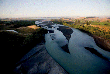
Ahuriri, Ngaruroro and Karamū (Figure 1) and includes the Heretaunga Plains, the major urban centres
of Napier, Hastings and Havelock North and the estuarine and coastal receiving
environments.
The
Greater
Heretaunga and Ahuriri Plan Change will seek to implement the
Hawke’s Bay Land and Water Management Strategy and the National Policy
Statement for Freshwater Management and will address specific water allocation
and water quality issues in the catchment.
The Greater Heretaunga and
Ahuriri region
is large and diverse, and the water related issues complex. Because of this
complexity, the Council has asked a group of Hawke’s Bay residents to make
recommendations on how these water bodies should be managed. The TANK
Collaborative Stakeholder Group (named after the four catchments) comprises 30
Hawke’s Bay representatives from agricultural and horticultural
sectors, tangata whenua, environmental and community interest groups, and
government agencies.
The
TANK Group has held 11 full day meetings plus other small group meetings and
workshops over the past 14 months to discuss the issues and to seek sustainable solutions to
the region’s freshwater challenges. HBRC has given a good faith commitment
to support any consensus recommendations from the TANK Group and to ensure the
Plan Change is consistent with the Group’s recommendations.
This
report summarises the work of the TANK Group to date. The report documents a
number of provisional agreements. These include statements of values,
objectives and some performance measures. The merits of current and alternative
policy options (for influencing outcomes) have also been discussed at length.
Without having comprehensively tested the consequences of adopting various
options against objectives for each catchment, there has been agreement on the
merits of a number of approaches that the group wish to document and use as a
basis for further analysis and consultation. The group has also identified a
number of information gaps that limit our ability to come to an agreement or to
predict the consequences of implementing policy options. Priorities for
research and monitoring are identified. Many of these agreements are related to
‘next steps’ – and will be further developed by the group through 2014 and
beyond as technical information becomes available and the Plan Change is
drafted. The
purpose of this report is to:
· Summarise
land and water issues in the Greater Heretaunga and Ahuriri region
· Inform
interested parties about land and water management in the Greater
Heretaunga and Ahuriri region
· Summarise
the process used by the TANK Group for identifying values and objectives and
evaluating policy options for setting freshwater limits
· Confirm
agreements of the TANK Group to date and clarify areas for further discussion
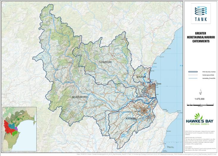 Figure 3: Greater Heretaunga and Ahuriri Catchments
3. Context
Hawke’s
Bay Regional Council is reviewing the current provisions of the Regional
Resource Management Plan (RRMP) for the management of surface water and
groundwater resources in the Greater Heretaunga and Ahuriri region. The Greater
Heretaunga and Ahuriri Plan Change will be required to give effect to, and be
consistent with, the following higher level documents:
- Resource
Management Act
- National
Policy Statement for Freshwater Management
- National
Environmental Standard for Sources of Human Drinking Water
- Hawke’s
Bay Land and Water Management Strategy
- Regional
Policy Statement
- HBRC’s Long Term Plan
In
addition, the Plan Change must take into account iwi planning documents lodged
with HBRC.
Resource Management Act
The
Resource Management Act 1991 (RMA)
is the key legislation governing the management of New Zealand’s freshwater
resources. Under the RMA, regional and unitary councils are responsible for
making decisions on the allocation and use of water within their boundaries and
for managing water quality. Central government can guide and direct regional
councils under the RMA using tools such as national policy statements and national
environmental standards.
National Policy
Statement on Freshwater Management
The
National Policy Statement on Freshwater Management (NPSFM) came into effect on
1 July 2011. The NPSFM requires regional councils to set freshwater
objectives, water allocation limits and water quality targets for every water
body, so that overall quality of freshwater in the region is maintained or
improved. For the most part, it is the Regional Council’s responsibility to
implement the NPSFM and the primary policy instrument for doing this is the
regional plan.
The
NPSFM requires councils to set objectives and apply corresponding limits/levels
to types of water bodies or areas and/or to have catchment and sub-catchment
specific objectives and limits/levels, where the characteristics of catchments
and sub-catchments demand different priorities. These limits may relate to
water quantity allocations, minimum flows, and a variety of water quality
parameters.
Every
regional council must implement the NPSFM as promptly as is feasible so that it
is fully completed no later than 31 December 2030. The Hawke’s Bay
Regional Council has identified a programme of activities for the preparation
of regional plan changes and the associated resource investigations. In
September 2012, the Council adopted its programme of progressive implementation
steps to fully implement the NPSFM by 2030. This includes a number of catchment
based plan changes, one of which is the Greater Heretaunga and Ahuriri Plan
Change. The implementation programme builds on work and projects already
underway before the NPSFM came into effect, as well as incorporating a number
of new workstreams.
National
Environmental Standard for Sources of Human Drinking Water
The
National Environmental Standard for Sources of Human Drinking Water (the NES)
2008 aims to reduce risks to the quality of water bodies from which
drinking-water supplies are taken. The NES requires regional councils to
consider the effects of activities on these water sources in their decision
making. Hence the Greater Heretaunga and Ahuriri Plan Change will need to be
consistent with the NES.
Hawke's Bay Land
and Water Management Strategy
As
well as giving effect to the NPSFM, the Council’s future work programme of plan
changes will seek to implement relevant parts of the 2011 Hawke's Bay Land and
Water Management Strategy (LAWMS). The LAWMS provides a common focus for
the management of land and water in Hawke’s Bay in order to achieve improved
economic and environmental outcomes. The overall vision of the LAWMS is:
In
Hawke’s Bay, land and water are highly valued, used wisely and sustainably
managed
– by all, for all.
A
range of outcomes are anticipated from implementation of the LAWMS. Plans
and policies prepared under the RMA are an important means to implement the
LAWMS, albeit they are not the only tools to be used to implement the strategy.
Regional Resource
Management Plan (including Regional Policy Statement)
The
Regional Resource Management Plan (RRMP) provides a framework within which the
sustainable management of the region’s natural and physical resources can be
undertaken, and sets out a policy framework for managing resource use
activities in an integrated manner across the whole of the Hawke's Bay region.
This
RRMP has legal force under the RMA. That is, the regional rules contained
within it have the force and effect of a regulation under the Act. The Regional
Council must have regard to the provisions of the RRMP when considering
applications for resource consents. In addition, territorial local authorities
within Hawke's Bay must ensure that their district plans are not inconsistent
with the provisions of this RRMP.
The
RRMP currently contains broad freshwater management objectives, water quality
guidelines (both at a regional and catchment specific level for a number of
parameters) and water allocation limits and minimum flows for specific reaches
of river in a number of catchments. However, these need to better align
with the NPSFM and also have appropriate regard to the LAWMS – both of which
have emerged since the RRMP was finalised in 2006.
Over
the past few years, the Council has been advancing a catchment-based approach
to RRMP plan changes to address specific resource management issues in the
region. The NPSFM Implementation Programme continues that approach.
Change 5 to the Regional Policy Statement is the lead initiative of the
Regional Council’s NPSFM Implementation Programme. Change 5 goes some way
to inform the establishment of freshwater objectives by setting out a framework
within which values, objectives and limits can be developed and included in
regional plans.
HBRC
proposes to publicly notify a change to the relevant sections of the RRMP for
the Greater Heretaunga and Ahuriri catchments by December 2016.
The TANK Group
believes
that the catchment-based plan changes being undertaken for the RRMP need to be
consistent wherever possible. Many of the people involved in the plan change
deliberations are the same across the Hawke’s Bay catchments and many of
the same issues are being addressed.
The
first catchment under review is the Tukituki (Plan Change 6) and plan
change deliberations are well advanced. The TANK Group considers that
re-litigation of many of the issues in the Tukituki may not be necessary and
that agreements reached in Plan Change 6 may be able to be used in the Greater
Heretaunga and Ahuriri Plan Change. However, it is also possible
that the Greater
Heretaunga and Ahuriri Plan Change could improve the approaches
taken in Plan Change 6 and the TANK Group wishes to keep these options open.
 Regional Plan Changes – interim agreement
1. The
TANK Group will review the Tukituki Plan Change once it is completed and
consider whether to use the same approaches where the same issues arise in the
Greater Heretaunga and Ahuriri Plan Change so that where appropriate the RRMP
is consistent across catchments.
4. The TANK Collaborative Stakeholder Group
Collaboration
is at the core of this Plan Change process. The aim is to provide the Council
with consensus stakeholder recommendations regarding objectives and policies
for the plan change (and perhaps other related actions). For its part, the
Regional Council has given a good faith commitment to implement consensus
recommendations providing that they are consistent with the higher level
documents noted above. It is hoped that this process will produce policy
recommendations to the HBRC that are broadly supported by the community and
underpinned by science.
Using a
collaborative approach to freshwater planning is a key recommendation of the
Land and Water Forum (2012) which notes that although collaborative planning is
unlikely to be cheaper in the short term, significant benefits are likely. The
process should help to increase the quality of and commitment to freshwater
planning and policy documents, increase the agility of the planning framework,
and streamline consent requirements for proposals that accord with agreed
objectives. The Land and Water Forum believes that if done well –and
effectively “dovetailed” with existing legal processes – a collaborative
approach to freshwater governance has the potential to lead to longer term
solutions that are more resilient and adaptive to change, and avoid more
costly, drawn-out and divisive decision-making processes. In the longer term,
then, a collaborative plan and policy making process may be faster, more
efficient and more equitable than the status quo process.
The
members of the Greater Heretaunga-Ahuriri Collaborative Stakeholder Group (TANK
Group) reflect a broad range of interests in freshwater management in the TANK
catchments, and provide a cross-section of values, understanding and
perspectives. The goal is for the group to be as representative as possible
while accepting that it needs to be kept to a size that can work effectively
together. To extend the collaborative dialogue further, TANK members are
engaging with their organisations and wider social networks to explain what is
happening in the collaborative process and to get feedback from them on the
matters under consideration. Interested members of the public can contact their
representative or any of the Regional Councillors on the TANK Group if they
would like to know more or express a view.
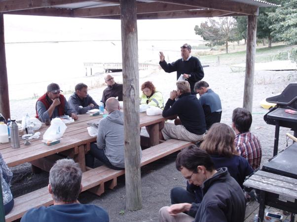
Figure 4: Mike Glazebrook talking to the TANK Group at Te Tua Station;
Field trip, February 2013
TANK
Group members are expected to represent the interests of their organisations
and networks in the search for consensus. Each member has to consider whether
supporting a consensus, even if the recommendations are not everything they or
their organisation would like, is better than the uncertain outcome they would
face if they choose instead to contest the issues through an adversarial
process. Thus, rather than simple advocacy for particular views, TANK Group
members are expected to genuinely explore, consider, and deliberate on
solutions that accommodate the broad range of interests that the Group members
represent, and to refrain from divisive tactics. To this end, the group has a
protocol for collaborative deliberation and an independent facilitator.
In this
process, the TANK Group and Regional Council are being supported by a team from
Landcare Research, the Cawthron Institute and the National Institute for Water
and Atmospheric Research (NIWA), funded through a research grant from central
government. Their objective is to learn how to design and support collaborative
processes that accommodate diverse values and deliver improved outcomes from
freshwater management, so that these lessons can be shared with other communities
and councils around New Zealand.
5. Tangata whenua and Mana whenua
Since
the time of Kupe, tangata whenua have long valued the life-sustaining capacity
afforded from the region’s rich and diverse waterways. The taonga tuku iho
(treasures handed down by our ancestors) of whenua (land), nga wai katoa (all
waters), mahinga kai and all living things, have, from mai rā anō
(time immemorial) influenced the location of whānau, marae, hapū and
iwi, and integral to their identity. For example the names of many marae are
linked to these waterways, Kohupātiki, Ruahāpia,
Waipatu, Waiōhiki and Mangaroa to name a few.
It is
recognised that a small number of individuals do not speak on behalf of all
tangata whenua who have interests in these combined catchments, and also
acknowledged that some marae / hapū are not represented or have been
unable to fully engage in the process thus far. The current participants have
made a conscious attempt to consider and put forward the general interests of
the relevant whānau, hapū and iwi. This has involved a number of hui
amongst tangata whenua to discuss the key issues and ultimately assist in
contributing to the TANK process. It has been expressed that too many
waterways of significance to tangata whenua have been included in this process,
thus limiting the effectiveness of appropriate input and consideration. Also,
localised issues, around specific marae or in relation to particular hapū,
have not been discussed in detail as yet. That will be the focus of ongoing work,
and there is recognition that many more discussions are needed to bring forward
an enduring and robust outcome. When considering options for improved
freshwater management, tangata whenua have looked at how the following key
Māori values can be incorporated into the Plan Change:
- Whakapapa
- Mana
- Wairua
- Mauri
- Taonga
- Kaitiakitanga
These
values are common throughout Ngāti Kahungunu and may differ slightly in
terms of expression from hapū to hapū or from whānau to
whānau; they are by no means an exhaustive list of values. History and
experience has demonstrated that there has been difficulty in their effective
and meaningful application, interpretation and implementation within the
resource management framework in general. From the tangata whenua discussions
it has been recognised a ‘gaps analysis’ is necessary to identify where there
are weaknesses in terms of advocacy to bolster existing plan provisions or to
draft new provisions that would be enduring and able to leverage tangata whenua
aspirational goals around freshwater use, governance, management and
kaitiakitanga. For example, the current definition of Mauri in the RRMP
glossary does not encapsulate the full meaning in accordance with tikanga
Māori. Consequently there is a risk that during plan implementation, some
elements of Mauri are not given appropriate weight in decision-making
processes.
This
collaborative stakeholder process has had a number of benefits; it has
identified the need to promote an understanding of tangata whenua values amongst
other stakeholders, resource users and managers. Despite these values being
expressed for a very long time, how they relate to each other and the holistic
relationship tangata whenua have with the natural environment is not always
well understood. For example, tangata whenua value the entire river, not merely
specially designated areas; ngā wai are seen as inseparable.
Tangata
whenua have also expressed that they have interests over and above the cultural
or environmental considerations which are commonly recognised, i.e. economic
and social considerations. Historically, the waterways provided an asset base
and sustained tangata whenua socially and economically; this relationship has
been adversely affected and there is a desire for it to be resurrected so it
becomes more meaningful and less abstract. Ngāti Kahungunu tangata whenua,
whānau, hapū and iwi maintain that they have never relinquished their
rights and interests to these taonga (waterways).

Tangata
whenua and Mana whenua - TANK Group Interim Agreements
2. The TANK Group recognises the following:
a. That the relationship
between tangata whenua and freshwater is longstanding and fundamental to their
culture
b. That water is valued by
tangata whenua as a taonga of paramount importance
c. That kaitiaki have obligations
to protect and enhance the mauri of water and the associated environment
d. That tangata whenua have an
obligation to be involved in freshwater decision-making
e. That the relationship
between tangata whenua and mana whenua and their wāhi tapu, wāhi
taonga and other taonga must be protected.
f. Ngāti Kahungunu
whānau, hapū and iwi have rights and interests in freshwater that
extend beyond the “cultural” space. While this has been discussed, exactly how
this might manifest remains uncertain.[5]
Figure 5: Marae locations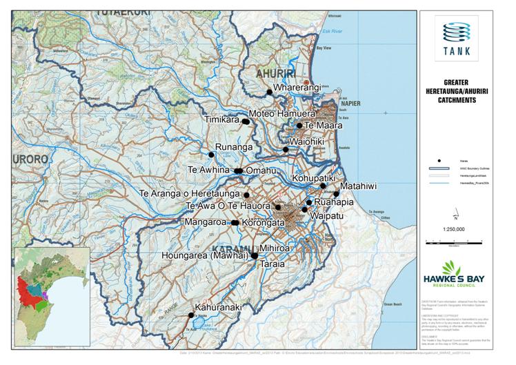
1.
6. The TANK Group decision making process
The
TANK group is identifying and assessing the issues and options for freshwater
management in the Greater Heretaunga and Ahuriri catchments. In many ways, the
group is performing the “section 32 analysis” (consideration of alternatives,
costs and benefits) required under the Resource Management Act.
To
do this, the TANK Group is utilising a Structured Decision Making process. This
consists of group members identifying their “Values” and “Objectives”, as well
as “Performance Measures”, and “Management Variables” (see Table 2 for a
hypothetical example), which are used to identify “Policy Options” and estimate
the “Consequences” of these options (see Table 3 for a hypothetical example).
These terms are briefly defined as:
- Values: Activities,
uses or sources of value (from freshwater systems), “things that matter”.
- Objective: A
desired outcome in a thing that matters (e.g. increase the suitability of water
for swimming, generally or in a particular location).
- Performance
measures:
A specific metric for consistently assessing the consequences of taking an
action or set of actions (i.e. criteria for evaluating options). These may
later be used to measure and report on the actual outcomes achieved once
policies are implemented.
- Management
Variables:
Aspects of freshwater management that can be directly controlled or indirectly
influenced by the Hawke’s Bay Regional Council (e.g. allocation limits) in
order to achieve management objectives.
- Policy Option: An action
or set of actions, using the Management Variables available, that could
be taken to advance the achievement of one or more objectives.
- Consequence: An
expected result of taking an action or set of actions, i.e. of implementing an
option.
Using
this framework, the TANK Group has begun the process of identifying and
assessing options for the four catchments. Some policy options will be generic
across the Greater Heretaunga and Ahuriri area (e.g. a target for security of
supply for water users), whereas others will be specific to a catchment or
reach (e.g. a flow setting or water quality limit based on a particular use or
value). Each option is assessed to estimate its likely consequences in terms of
stakeholder values as represented by the performance measures. The group then
tries to refine the policy options to find ways that better meet the full set
of values, so that everyone has a reason to support it.
Table 2: Hypothetical example of the decision making process
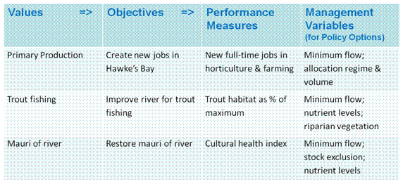
Table 3: Hypothetical examples of the consequences of different
Policy Options
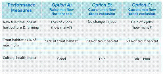
To
support the Structured Decision Making process, the TANK Group has also been
developing models called Bayesian Belief Networks (BBNs). These networks are
used to try and capture our understanding of the cause-effect relationships
between management variables and performance measures, often using
“intermediate variables” for complex, indirect relationships. The BBNs can be
used in a diagrammatic form (called an “influence diagram”) or they can be
developed to show how much one component, or “node”, affects another,
and to reflect uncertainty. This is achieved by attaching probabilities based
on available science (or best judgements where scientific knowledge is not available)
to different possible states of each node, for example the probability of Trout
fishing (the node) being “poor”, “fair”, “good”, or “excellent”. Once the BBNs
are agreed upon they can be used by the Group to estimate the consequences of
alternative policy options. In this way the BBN itself does not make the
decision, but rather supports decision-making, and also helps to show how
decisions were made and what assumptions were made in the process.
The
TANK Group created BBNs (in influence diagram form) in small group sessions
based around tangata whenua, social, ecological, and economic themes (Figure
6). Figure 7 shows the relationships between the fundamental “objectives”,
“sub-objectives”, “performance measures”, and “management variables” (note
Figure 7 is a small, incomplete part of the overall BBN included for indicative
purposes only).. These were then merged with BBNs of the other three themes to
show how all of these matters are connected. The next step is to quantify this
comprehensive BBN for each of the catchments so the group can use it to assess
consequences of policy options. The TANK group is not proposing to use
the BBN to automatically generate optimum or preferred policy choices. Rather
it is hoped that the BBNs will assist in making judgements transparent to all
stakeholders as well as allowing TANK group members to understand the
consequences of different judgements about cause-effect relationships and their
probabilities.
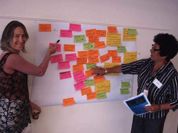
Figure 6: Developing an influence diagram
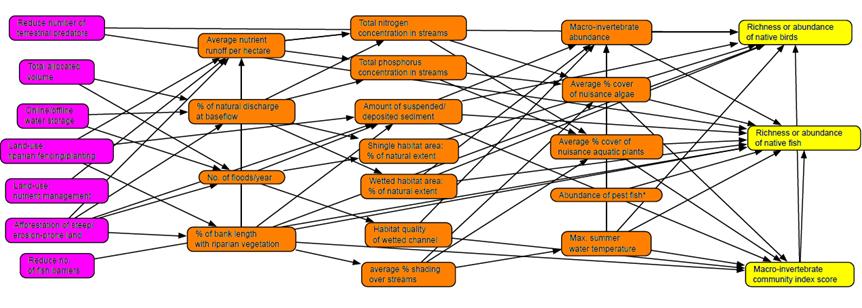
Figure 7: Example of an influence diagram (NB: this is not a
complete influence diagram)
7. TANK Group Values, Objectives, Performance Measures and
Management Variables
This
section outlines the Values, Objectives, Performance Measures and Management
Variables being developed by the TANK Group as part of the Structured Decision
Making process for freshwater limit setting. Some have been discussed in detail
and agreement has been reached by the Group (as noted in the text); others are
still being refined as more information becomes available.
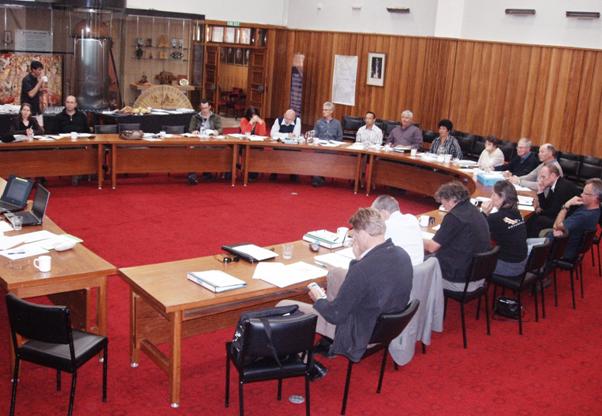
Figure 8: TANK Group discussions, October 2013
Values
Any
freshwater policy setting process needs to take into account multiple community
values and interests. The TANK Group has identified important freshwater values
for the Greater Heretaunga and Ahuriri region, many of which apply throughout
the region. The list of values considered important by TANK stakeholders are
either properties of freshwater or well-beings supported by the use of fresh
water and include (in no particular order):
· Life-Supporting
Capacity
· Human health and
wellbeing
· Food and fibre
production and processing
· Industrial &
commercial use
· Mauri, Wairua and
Taonga
· Kaitiakitanga and
Mana
· Whakapapa and Wahi
tapu
· Habitat /Indigenous
biodiversity
· Food gathering
· Swimming and wading
(Primary Contact recreation)
· Kayaking and
boating (Secondary Contact recreation)
· Trout fishing
· Amenity &
tourism
· Household and urban
water supply (for drinking and other uses)
There
are other values to consider when developing freshwater management policies,
which while not freshwater “values” in the sense of the list above, are
important aspects to take into account. These include:
· Urban development
· Flood protection
· Urban stormwater
management
· Net benefit of
policies
· Costs to ratepayers
The
values associated with water are numerous and seeking win-wins across all
values is challenging – but not impossible. All of the above values are
important and the TANK Group believes that the RRMP can and should aim to
support them. However, the individual catchments have very different
characteristics, and thus the significance of values varies. The TANK Group has
discussed the spatial variation of values and identified where values are
competing, which is where pressure on freshwater is greatest and the management
response is most difficult (see Section 8: Catchment specific topics). The
freshwater limit setting process needs to take account of this variation across
the region.

Values –
interim agreements
3. The
TANK group will use the values identified in each of the catchments to assess
the consequences of policy options and seek to identify options that provide
for each of these values.
4. The
TANK group will recognise spatial variation of catchments and their values in
the limit-setting process, by setting objectives and limits for sites and
reaches within catchments where appropriate.
Objectives
Once
Values were identified, the TANK Group undertook the task of developing
Objectives for supporting them. Objectives can be high level or ‘fundamental
objectives’ and also ‘sub-objectives’ which support fundamental objectives. The
TANK Group has identified Objectives which will underpin its recommendations
for the Plan Change. These are shown in Table 4.
Performance
measures
To
determine whether the Group’s Values and Objectives are likely to be met via
policy options, the impacts are estimated with Performance Measures. The
Performance Measures that the TANK Group is using were initially identified
through the influence diagrams described above, and then further refined by
thinking about how they could be defined and linked to Management Variables
through other parts of the complete “system”, i.e. the relationships between
people and the environment.
The
TANK Group’s Values, Objectives and related Performance Measures are brought
together in Table 4.
Table 4: Values, Objectives and Performance Measures identified
by the TANK Group
|
VALUES
|
OBJECTIVES
|
PERFORMANCE MEASURES
|
|
· Life-Supporting
Capacity
· Mauri
and Taonga
· Habitat
/Indigenous biodiversity
·
|
Safeguard the
life-supporting capacity and enhance the mauri of waterways
|
· Macroinvertebrate
assemblage incl. community index score
· Mauri
· Richness
and abundance of native fish
· Area
of wetlands
· Condition
of wetlands
· Mahinga
kai quality and availability
· Richness
and abundance of native birds
|
|
· Food
gathering
· Household
and urban water supply (for drinking and other uses)Human health and
wellbeing
|
Improve the health
of Hawke’s Bay communities
|
· Reported
cases of water-borne disease/yr
· Potable
water quality in groundwater
· Potable
water quantity (days of restrictions/yr)
· Potable
water quantity (Number of people with vulnerable supplies)
|
|
· Food
and fibre production and processing
· Amenity
& tourism
· Household
and urban water supply (for drinking and other uses)
|
Improve the
Hawke’s Bay economy
|
· Number
of jobs in water-dependent sectors
· Total
profit in water-dependent sectors
·
Certainty of water supply for water-dependent sectors (Number of years with <5
days full water restrictions)
· Net
benefit of policy measures
|
|
· Food
gathering
· Swimming
and wading (Primary Contact recreation)
· Kayaking
and boating (Secondary Contact recreation)
· Trout
fishing
· Amenity
& tourism
|
Improve
recreational freshwater opportunities
|
· Number
of sites*days suitable for swimming
· Water
flows for whitewater boating
· Water
flows for flat-water boating
· Aesthetics
of waters
· Angler
days
· Income
from freshwater related tourism
|
|
· Kaitiakitanga
· Mana
· Mauri
and Taonga
|
Recognise and
provide for tangata whenua values and interests in freshwater and improve
opportunities for Māori to access and use freshwater resources
|
· Tangata
whenua involvement in governance
· Use of
Mātauranga Māori in environmental monitoring and reporting
· Māori
water allocations
|
|
· Whakapapa
and Wahi tapu
|
Increase
identification, recognition and protection of wahi tapu and wahi taonga.
|
· Wahi
tapu register
· Tangata
whenua involvement in governance
|
Management
Variables
The
TANK Group has also identified a long list of Management Variables that could
be incorporated in policy options to help achieve desired objectives. Some of
these are within the control of HBRC while others are steps that landowners,
city and district councils, industry bodies and others could initiate
themselves. Within the things that HBRC can do, some are central to the Plan
Change for the Greater Heretaunga and Ahuriri area – such as minimum flows,
allocation limits, water quality limits and measures to achieve these – while
other Management Variables are things that HBRC could do outside the RRMP, such
as removing barriers to fish passage, increasing its technical assistance to
farmers, assisting with water storage proposals or funding riparian planting[6].
The
Management Variables directly linked to the Plan Change, i.e. those which the
Council is asking the TANK Group to make recommendations on, are as follows:
· Flow
regime
· Water
allocation (including for municipal and domestic supply)
· Security
of water supply setting
· Policies,
rules on groundwater /surface water connectivity
· Surface
water and groundwater quality limits
· 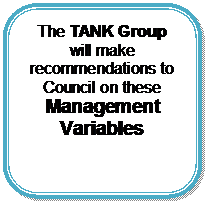 Tangata whenua
involvement in freshwater
Tangata whenua
involvement in freshwater
decision making
· Use
of Mātauranga Māori in monitoring and reporting
· Wahi
tapu register
· Policies,
rules and incentives on:
o riparian
management & stock exclusion
o water
storage
o water
efficiency
o water
sharing/transfer
o nutrient
loss/allocation
o good
irrigation practices
o stormwater
management
o other
agricultural practices
8. TANK region-wide topics
Managing
the four catchments holistically is important due to the interconnected nature
of the rivers, streams and groundwater (the Heretaunga aquifer underlies the
four catchments and the Ngaruroro and Tūtaekuri Rivers contribute to both
surface water and groundwater in the Karamū catchment). Although the
limits will vary by catchment or by management zone within or across
catchments, the approaches taken to set them will be the same.
This
section summarises TANK Group discussions on topics which apply to all four
catchments. Many of the topics concern Management Variables which, when set in
policy, will have an effect on a range of Values and Objectives. The
consequences of these policy settings on the Values and Objectives will be
assessed using the Performance Measures noted above.

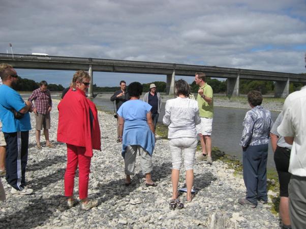
8.1. Minimum flows
Minimum flows are a
Management Variable which will have an effect on a range of Values and
Objectives including those associated with life-supporting capacity, mauri,
habitat, recreation and the economy. As a result there are multiple Performance
Measures which the TANK Group will use to assess the impacts of minimum flows
including richness and abundance of native fish, mahinga kai quality and availability,
potable water quantity, flows for boating and number of jobs in water-dependent
sectors.
The determination
of minimum flows needs to include assessments of impacts on fish habitat and
other ecological, cultural and recreational values, as well as the impacts on
irrigators, processors, and the wider community. Much of this work is still to
be undertaken, so the TANK Group is not currently in a position to make any
definitive recommendations. However, some agreements have been reached.
The pressures associated
with minimum flow setting vary throughout the four catchments:
· In the
Ahuriri there is no surface water abstraction and therefore there are few
problems for setting minimum flow limits
· Methodologies
for setting minimum flows in systems like the Karamū are not well
developed
· The
Tūtaekuri minimum flows provide high levels of ecological habitat
retention and security of supply for irrigators
· In the
Ngaruroro, much is still to be understood about the current minimum flow and
any need for change.
RHYHABSIM (River
Hydraulics and Habitat Simulation model) is a method used by scientists to
estimate the quantity of fish habitat in a river as a function of flow. When
using RHYHABSIM to inform decisions about minimum flows, the key factors are
the species of interest and the level of habitat retention required. The TANK
Group supports the use of RHYHABSIM but considers it important to also
translate the application of minimum flow thresholds into an equivalent
predicted impact on fish abundance. It is also important to know how other
human influences (e.g. nutrients) affect fish populations.
As noted above,
full impact assessments across the four well-beings (using Performance
Measures) need to be undertaken to support minimum flow setting.
 Minimum flows – interim agreements
5. The
minimum flow setting needs to take into account the impacts on environmental,
cultural, social and economic values using other methodologies (e.g.
Mātauranga Māori; economic models).
6. The
TANK Group supports the use of RHYHABSIM for minimum flow setting where
appropriate, to assess the implications of different flow regimes on the level
of habitat retention for a range of species.
8.2. Water allocation
Water allocation is
a Management Variable linked to minimum flow which will have an effect on a
range of Values and Objectives including those associated with human health and
access to public water supplies, kaitiakitanga and mana, and food and fibre
production and processing. As a result there are multiple Performance Measures
which the TANK Group will use for assessing the impacts of water allocation
including potable water quantity, certainty of water supply for water-dependent
sectors, and Māori water allocations.
The rate of take is
the key parameter for managing the allocation of surface water resources
because of the direct effect that taking from rivers has on the flow in the
river. For the allocation of groundwater, it is the annual volume that is a key
management parameter. The rate of take for groundwater is relevant when
assessing interference effects on other groundwater users.
The current RRMP
allocation framework HBRC provides for 95% security of supply to water users.
It provides an allocation limit for a river that is the difference between the
7-day average flow that is exceeded 95% of the time over the summer months and
the minimum flow. On average, this means that water users are likely to be under
restriction no more than 5% of the time, i.e. have 95% security of
supply. Up
until 1999 (proposed RRMP notified) consents were granted on existing use
determined by the crop and area of land to be irrigated. Since the RRMP was
notified, water allocation for irrigation has been largely based on the crop
water requirements for a 1 in 5 year drought event using the Morgan
methodology.
The NPSFM requires
that the Regional Council not over-allocate water. Determining actual
allocation status is difficult without detailed abstraction data. As more water
use is metered and telemetered, Council is able to get a better understanding
of the status of water allocation. By the methodology used in the RRMP,
the Tūtaekuri catchment is under-allocated, the Ngaruroro fully allocated
and the Karamū over-allocated by virtue of many reaches having a zero
allocation limit. However, these are conservative estimates as they assume all
consented water is used concurrently when it is unlikely that all irrigators
will irrigate at full capacity at the same time. Recently collected telemetry
data shows that this is not the case. Some members of the TANK Group believe
actual water use is less than the allocation limit and therefore current takes
are not putting the catchments into an actual over-allocation state. The
suggestion is that a different methodology for determining the allocation limit
may be required.
Consented
water allocations in Hawke’s Bay are given a maximum rate of take
(instantaneous) and a weekly or monthly allocation volume. The maximum rate of
take is supported by the TANK Group but weekly allocations are, in practice
found to be impractical to manage at a user level. As such, monthly allocations
are supported by the TANK Group.

Water
allocation – interim agreements
7. The
TANK Group recognises that the RRMP needs to give effect to the NPSFM by
ensuring that water is not over-allocated.
8. The
TANK Group believes that alternative methods for determining total water
allocation limits should be explored as a possible substitute for a simple sum
of all authorised abstractions.
9. The
TANK Group considers that monthly, rather than weekly, allocation volumes for
water take consents are appropriate (as well as a ‘rate’).
8.3. 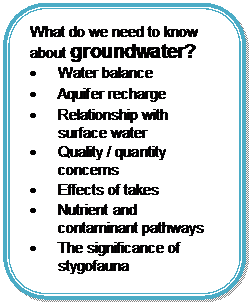 Groundwater investigations
There
are around 2000 groundwater takes in the Greater Heretaunga and Ahuriri region
(Figure 10). Improved understanding of groundwater resources and functions is a
fundamental requirement to inform the setting of many of the Management
Variables identified including flow regime, water allocation and policies, and
rules on groundwater /surface water connectivity.
Figure 10: Groundwater takes in Greater Heretaunga and Ahuriri
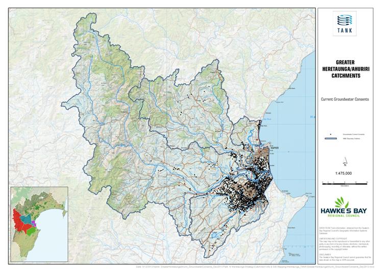
To
give effect to the NPSFM, a sustainable level of groundwater abstraction needs
to be determined and an allocation limit set.
Concerns
raised in TANK Group discussions are that the existing groundwater model does
not predict likely effects of any changes in
groundwater use and is limited in its capacity to inform the setting of an allocation
limit. The connectivity between surface water and groundwater and the effect of
river flow on aquifer recharge has not been well understood in the past but
information collected over recent years is helping with that understanding. It
is anticipated that HBRC will have developed a coupled surface water /
groundwater model for assessing connectivity and stream depletion effects to
inform Plan Change decisions.
To
improve water supply security, the TANK Group wants HBRC to explore whether it
is feasible to supplement surface water flows (where restrictions occur) from
the confined aquifer (where there are no restrictions). This was trialled
to good effect in the Raupare in the summer of 2012/13.
The
TANK Group notes that investigations in New Zealand and Australia suggest that
stygofauna may provide essential ecosystem services that contribute to ground
water dynamics and nutrient attenuation. The group believes more research
should be undertaken to understand the importance of these organisms as well as
factors that might affect their capacity to maintain ground water quality,
groundwater flow and effects on groundwater dependent surface water ecosystems.
The Group notes that Napier City Council and Hastings District Council take
water that is more than a year old to ensure pathogens are not present.
There
are many hundreds of groundwater takes in the Greater Heretaunga and Ahuriri region
whose stream depletion effects need to be determined. The TANK Group
considers that the 400m stream depletion rule in the RRMP is too coarse,
arbitrary, and not effects-based. The approach taken in the Tukituki Plan
Change 6 may be an improvement and the TANK Group will consider supporting that
approach for the Greater Heretaunga and Ahuriri Plan Change.

Groundwater
– interim agreements
10. The
RRMP needs to be informed by a better understanding of the groundwater
resources so that limits can be set. The TANK Group supports ongoing HBRC
groundwater investigations and considers that these investigations should include:
a. Water
balance (How much water can sustainably be abstracted?)
b. Aquifer
recharge from surface water
c. Relationship
with surface water (stream connectivity, depletion effects and ecology)
d. Areas
of concern (quantity and quality)
e. Specific
detailed investigations into the effects of individual takes in the unconfined
and semi-confined areas of the Heretaunga aquifer
f. Nutrient
and contaminant pathways
g. The
significance of stygofauna.
11. The
TANK Group believes that supplementation of surface water flows from the
confined aquifer should be explored.
8.4. Measures for improving water use efficiency
Measures for
improving water use efficiency are Management Variables which will have an
effect on a range of Values and Objectives including those associated with
public and commercial water supplies, kaitiakitanga, habitat and the economy.
Performance Measures which the TANK Group will use for assessing the benefits
of water use efficiency measures will include potable water quantity, richness
and abundance of native fish, certainty of water supply and number of jobs in
water-dependent sectors.
8.4.1. Municipal water use efficiency
It is important
that water efficiency measures are adopted by all sectors and all sections of
the community, as all water use has a depletion effect on the region’s water
resources. While irrigation is the largest water use in the region, municipal
takes are also substantial. Irrigators are exploring options for making water
go further including good irrigation practices, global consents and staged
reductions for water abstraction. The TANK Group believes that suppliers of
municipal water for urban and industrial use should also be exploring water
efficiency measures and that these suppliers should have demand management and
conservation strategies. Strategies could include procedures for low flow
restriction periods and educational initiatives for the community.

Municipal
water use efficiency – interim agreements
12. The
TANK Group considers that municipal water suppliers should have demand
management and conservation strategies.
13. The
TANK Group believes that some restrictions on urban and permitted domestic
water supplies are appropriate in certain circumstances, such as when other
abstractors from the same or connected resources are experiencing significant
water restrictions and/or bans.
8.4.2. Good irrigation practices
Most crops in the
Greater Heretaunga and Ahuriri region are dependent on irrigation water and the
2013 drought saw many growers on the Heretaunga Plains facing water
restrictions and crop loss. Some of the issues associated with water
shortages in the Greater Heretaunga and Ahuriri region could be
mitigated if good irrigation practices were adopted by all
irrigators.
Most
industries have Industry Good Practice (IGP) programmes established which
include irrigation practices. The TANK Group believes that all water
consent holders should be adhering to their own industry IGP programme, and
that evidence of this should be provided to the Regional Council.
 Good irrigation practices – interim agreements
14. The
TANK Group considers that all water consent holders should be required to
provide evidence to HBRC (at a frequency to be determined) that they are
compliant with industry IGP irrigation practices.
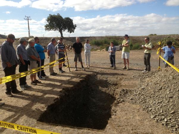
Figure 11: Good irrigation practices are a necessity in
gravel-dominated soils like the Gimblett Gravels; Field trip, February 2013.
8.4.3. Global consents and water sharing
Global consents
involve the combining of a number of consents into a single consent and
allocation of water (rate and volume).
Global consents are
already possible within existing RRMP rules and HBRC is participating with
growers to assist in setting them up, e.g. with Twyford Irrigators Group and
Ngaruroro Water User Group. However, there are difficulties of getting growers
who have adequate supply to join a global consent when they perceive there to
be little individual benefit.
For a global
consent, all takes need to be telemetered and transfer of water can
only be between homogeneous systems and not from groundwater to surface water.

Global
consents and water sharing – interim agreements
15. The
TANK Group encourages HBRC to continue to work with water user groups to assist
with setting up global consents.
16. The
TANK Group would like to see a process for instantaneous transfers of water
consents[7]
and will aim to identify the circumstances where this would be appropriate.
8.4.4. Staged reductions
The current regime
for water restrictions in the RRMP is that when rivers drop to minimum flow
levels, most abstractors are required to cease abstraction. The TANK Group
believes that while this “on-off” policy may be appropriate for some
catchments, in others it may be too blunt and other, more sophisticated
mechanisms should be explored.
Water consent
holders seek flexibility in the exercising of their consents including options
to utilise staged
reductions, i.e. reduce water takes at different stages to help to delay
or prevent rivers from reaching minimum flow restrictions. In dry
years irrigators could work out the most appropriate system of cutbacks for a
river or stream taking into account the water requirements of different crops.
Avoiding bans on
irrigation is only one side of the coin. There are multiple
benefits of staged reductions including to in-stream values because under a
staged reduction regime, river flows stay at higher flows for longer.
The benefit of
staged reductions for irrigators will depend on a number of hydrological
factors. These include the rate of flow recession (how quickly flow drops in a
drought), the rate of take, and the lag between point of take and stream flow.
With a fast rate of flow recession and small net take, staged reductions will
result in only a short extension of irrigation season prior to ban. For a slow
rate of recession and large net take, the stage reduction will result in a
greater extension of irrigation season prior to ban.
Due to the varying
benefits, staged reductions should be assessed on a catchment by catchment
basis once information is gathered on how rivers or aquifers would respond. For
staged reductions to work, all abstractors of water from a zone with a staged
reduction policy will need to be managed under a single global consent and all
takes will need to be telemetered.
Figure 12
represents a theoretical model of how a stage reduction policy might work. The
nature and number of thresholds and the staged reduction values have been
chosen simply to help explain the concept and could be very different in the
final event, should such a policy be pursued.
The green downward
sloping curve represents the river flow reducing over time due to no rainfall.
The minimum flow restriction would begin on the 22nd day of no rain (@ approx
4200 L/s) and all abstraction would cease. Under a staged reduction regime,
irrigators begin to reduce their water abstraction when the river drops to MALF
or 6000 L/s by 30%. This change in river flow is represented by the
multi-coloured staggered line in the graph. As the takes are reduced, the river
level rises and then starts to fall again in the absence of rain. At the next
threshold, 90% of MALF or 5400 L/s, water abstraction is reduced by a further
30% and the river level rises again. Further reductions occur at 80% of MALF.
At 70% of MALF, the minimum flow is reached and no takes are permitted.
In this theoretical
situation, total water restrictions without staged reductions would have
started on the 22nd day without rain. With staged reductions, this has been put
off to the 38th day.
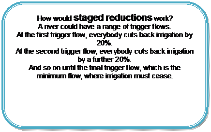
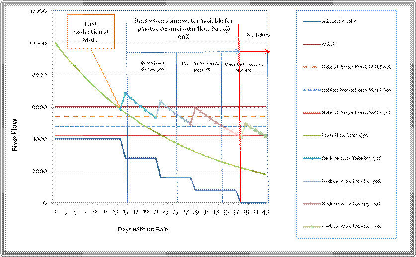
Figure 12: Theoretical staged reduction regime
 Staged reductions – interim agreements
17. The
TANK Group considers that HBRC should investigate the benefits of staged
reductions of water abstraction in the Greater Heretaunga and Ahuriri region.
For staged reductions:
a. A
global consent for a surface water zone would be preferable
b. Incentives
will be needed to participate in a staged reduction policy (e.g. lower minimum
flow restrictions)
c. Telemetry
will be required for all water users participating in a staged reduction
policy.
8.5. Water storage
Water storage is a
Management Variable which will have an effect on a range of Values and
Objectives including those associated with social, economic and recreational
opportunities. Numerous Performance Measures will be used by the TANK Group for
assessing the impacts of water storage including mauri, area of wetlands,
certainty of water supply for water-dependent sectors, and potable water
quantity.
There is general
agreement that Hawke’s Bay receives plenty of rainfall but there is not always
water where and when people need it. Water storage increases the security of
supply for abstractors so that they can continue using water when they would
otherwise be on a ban, and potentially provides for the augmentation of river
flows to retain or improve water quality and ecological values. Water storage
is also recognised as a way in which communities can build resilience around
drivers such as climate change and increase economic prosperity. Iwi would like
to have their own storage for community supply as well as for improving habitat
e.g. for tuna.
Water storage does
not just mean large scale run-of river dams, although this is one approach.
What is meant by water storage includes “water harvesting” and could include
the following (none of which are prohibited in the current RRMP):
· Water
harvested at high flows
· On
farm-storage
· A number
of distributed dams across a catchment that integrate storage needs
· Greater
storage within soil itself such as within the humus layer
· Techniques
that utilise gradient to optimise rainfall retention
The TANK Group
believes that in the Greater Heretaunga and Ahuriri region, large
scale storage is only likely to be needed if existing minimum flow and
allocation regimes change.
 Water storage – interim agreements
18. The
TANK Group believes farming practices which maximise water retention in the
landscape is likely to reduce irrigation demand and hence reduce the need for
large scale water storage in the Greater Heretaunga and Ahuriri region.
19. To
maintain current levels of food and fibre production, the TANK Group considers
that water storage will be required if allocations are reduced and/or minimum
flows are increased.
20. The
TANK Group encourages HBRC to make allocations of high flows more easily
available for on-farm and/or community storage and distribution[8] through the
consenting process.
8.6. Nutrient Management
Nutrient management
is a Management Variable associated with water quality limit setting which can
involve policies, rules and incentives on nutrient loss, riparian management
& stock exclusion. Values and Objectives associated with nutrient
management include safeguarding the life-supporting capacity and mauri of
waterways, improving social freshwater opportunities and the Hawke’s Bay
economy. Performance Measures which will be used by the TANK Group for
assessing the impacts of nutrient management policies include mauri,
macroinvertebrate community index score, mahinga
kai quality and availability, angler days, potable water quality and
total profit in water-dependent sectors.
There are some
water bodies (or parts of) in the Greater Heretaunga and Ahuriri region where
nutrients are elevated and causing increased algal growth, e.g. in the middle
and lower Tūtaekuri. The majority of nutrients are coming from runoff and
leaching from farms and “critical source areas” are being identified. On-farm
nutrient management is necessary to reduce nutrient runoff, maintain
life-supporting capacity, help avoid proliferations of algal growths (and
others such as cyanobacteria) and also to avoid toxicity to aquatic species and
protect drinking water supplies.
Like water use
efficiency, many nutrient issues could be mitigated if good agricultural
practices were adopted by all landowners. The TANK
Group believes that all farmers should be adhering to their own industry IGP
programme, and that evidence of this should be provided to the Regional
Council.
As well as
adherence to IGP, all landowners within prioritised catchments should be
required to develop and implement farm management plans which include nutrient
budgeting. Evidence of compliance with farm management plans should be provided
to the Regional Council and disincentives placed on landowners who fail to
demonstrate adherence to their farm management plans.
Nutrient management
approaches being developed for the Tukituki Plan Change 6 (e.g. stock exclusion
rules and identification of critical source areas for nutrients) may be able to
be adapted for the Greater Heretaunga and Ahuriri region.
(NB. Macrophyte
growth in lower Karamū may be enhanced by nutrients but the issues are
complex and the most appropriate way to suppress growth may be through riparian
shading).

Nutrient
management – interim agreements
21. The
TANK Group agrees that nutrient management is necessary to help maintain
life-supporting capacity, avoid proliferations of undesirable algal growths,
avoid toxicity to aquatic species and protect drinking water supplies.
22. The
TANK Group believes that all farmers should be required to provide evidence to
HBRC that they are compliant with industry IGP nutrient management practices.
23. The
TANK Group considers that policy and management measures should target
“hot-spot” areas where the values identified by the TANK Group are being
compromised or at risk of being compromised by excessive nutrients. These areas
need to be identified as well as the critical source areas for nutrients.
24. The
TANK Group agrees that farm environmental management plans, which may go beyond
IGP, should be mandatory for all landowners in “hot-spot” areas.
25. The
TANK group recommends that monitoring of ground water nutrients take into
account appropriate temporal lags between nutrient management practice and
measured nutrient concentrations in ground water samples.
8.7. Stock exclusion
Stock exclusion is a
Management Variable which will have impacts on ecological, recreational,
cultural and economic Values and Objectives. Performance Measures for assessing
the impacts of stock exclusion policies include
mauri, macroinvertebrate community index score, mahinga
kai quality and availability, angler days, potable water quality, total
profit in water-dependent sectors and net benefit of
policy measures.
The TANK Group
considers that stock exclusion rules should be
consistent across catchments and that many of the Plan Change 6 policies may be
appropriate for the Greater Heretaunga and Ahuriri region Plan
Change. However, the Greater Heretaunga and Ahuriri area is also
very different to the Tukituki – the most obvious being that there is more flat
land – and there may be some variation which better suits the Greater
Heretaunga and Ahuriri catchments.
The main difficulty
around assessing stock exclusion options for managing nutrients in the Greater
Heretaunga and Ahuriri catchments is that nutrient limitation (N or P) in
waterways is still to be determined and problem areas have not been identified.
It is agreed by the
TANK Group that all cattle should be excluded from waterways but the challenge
is around how to manage sheep. In the Greater Heretaunga and Ahuriri region there
are a lot of flatland farmers (e.g. orchards & vineyards) who use livestock
at discrete times of the year such as to control weeds in winter and to help
reduce leaf area in summer. It is estimated that there are 500kms of drains
through orchards & vineyards in the Greater Heretaunga
and Ahuriri region and that fencing them all off may be impractical,
expensive and may not deliver the benefits expected.

Stock
exclusion – interim agreements
26. The
TANK Group supports exclusion of cattle from waterways in the Greater
Heretaunga and Ahuriri region.
27. In
catchments where stock (other than cattle) in streams is proven to be a
problem, the stock exclusion should be considered.
8.8. Stormwater management
Stormwater
management is
a
Management Variable which will impact on a range of Values and Objectives
including life-supporting capacity, mauri, wahi
taonga, human and ecological health and the Hawke’s Bay economy.
Performance Measures which will be used by the TANK Group for assessing the
impacts of stormwater management policies include macroinvertebrate assemblage
incl. community index score, mahinga kai quality and availability,
and net benefit of policy measures.
The TANK
Group has discussed both rural and urban stormwater issues which are
quite different in the Greater Heretaunga and Ahuriri area.
Rural issues are primarily sediment, pathogens and nutrient related while urban
issues include these as well as heavy metals, oils and illegal discharges (e.g.
paint, animal waste). Flat grades of land in urban areas result
in infrequent flushing flows, meaning that contaminants can persist in these
systems.
Catchments with
high levels of urban development, like the Ahuriri and Karamū catchments,
also have high volumes of surface runoff due to large areas of impervious
surfaces. Surface runoff invariably includes high levels of pollutants to
receiving environments with flat grades and infrequent flushing flows, such as
the Ahuriri Estuary and the Karamū Stream network which results in a gradual
decline in the health of these receiving environments.
Fish passage is
restricted throughout much of the stormwater network and the TANK group
believes that there are opportunities to improve these systems for fish
passage.
Many of the issues
associated with the stormwater networks are complex and date back many decades.
Napier City Council, Hastings District Council and HBRC all manage stormwater
and it will require collective action to effectively mitigate the adverse
effects of stormwater discharges in the Greater Heretaunga and Ahuriri catchments.
While the issues are complex, the TANK Group believes there are
potentially some “easier” wins including:
o Controls
on zinc roofing e.g. require all new roofing to be painted
o Bylaws
on design, operation and management of industrial sites
o Education
and knowledge transfer
o New
developments to be required to include sustainability attributes e.g. LIUDD Low
Impact Urban Design and Development
“Harder”
issues identified include:
o The
volume of water getting into the stormwater system
o Rural
stormwater overwhelming the urban system
o Drains
which have a base flow i.e. are not stormwater
o Joining
up disjointed or incomplete older networks exist
o Improving
fish passage
In 2009 a
collaborative stormwater working group, which included representatives from
HBRC, territorial authorities, HBRC’s Māori Committee, Fish and Game and
the Department of Conservation drafted a Regional Stormwater Strategy. The
Strategy identifies key outcomes of less flooding, reduced contamination,
improved environments and resilient communities. The Strategy was released for
public consultation where it received positive support.
The Regional
Stormwater Strategy
has not been adopted by any of the Councils to date as it was recognised that
it needed to be integrated into catchment approaches to water management.
The TANK Group
considers the Regional Stormwater Strategy to be a good starting point for
improved stormwater management.

Stormwater
– interim agreements
28. The
TANK Group recommends the re-establishment of the Regional Stormwater Working
Group (with possible inclusion of some TANK members) to review and where
necessary update the Regional Stormwater Strategy.
29. The relevant agencies involved in stormwater
management should investigate options including:
a. Controls
on zinc roofing e.g. require all new roofing to be painted
b. Bylaws
on design, operation and management of industrial sites
c. Education
and knowledge transfer
d. New
developments to be required to include sustainability attributes e.g. Low
Impact Urban Design and Development
8.9. Wetland management
There are few
remaining wetlands in Hawke’s Bay and the Greater Heretaunga and Ahuriri area
is no different. Remaining wetlands are important for a range of values
including biodiversity, cultural, and recreation values and the ecosystem
services they provide such as absorbing nutrients and trapping sediment.
Regional Councils are required by the RMA to sustainably manage these areas
through rules and policies in Regional Plans. Wetlands in the Greater
Heretaunga and Ahuriri area include Ahuriri Estuary, Waitangi Estuary, Lakes
Poukawa, Rūnanga,
Ōingo and Te Rotokare, Pig Sty Swamp and Pekapeka. Most of these wetlands
are recognised in the RRMP as “priority wetlands” and the Ahuriri Estuary is
recognised in the Regional Coastal Environment Plan as a “Significant
Conservation Area”. The braided river sections of the Ngaruroro and Tūtaekuri
Rivers,
which are classified as wetlands provide important habitat for riverine birds.
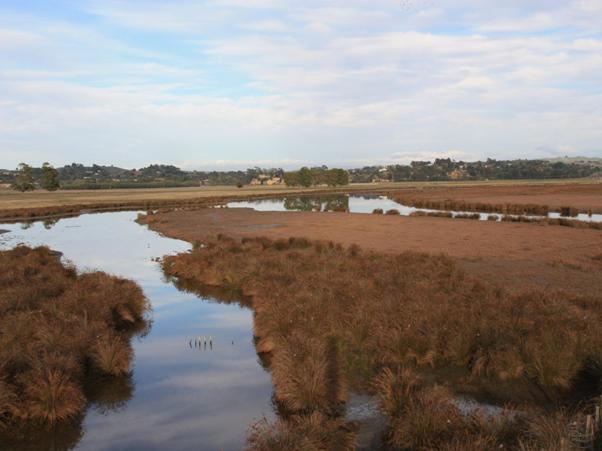
Figure 13: The TANK Group supports the preservation of Wetlands.

Wetland
management – interim agreements
30. The TANK Group recognises the importance of
wetlands in the Greater Heretaunga and Ahuriri region and believes that
measures should be undertaken to support the preservation of remaining
wetlands, consistent with other policy documents such as the Regional Policy
Statement and the NPSFM.
31. The TANK Group considers that wetlands should
be identified and categorised to determine ecological significance and that
wetlands deemed ecologically significant should be given protection that is
consistent with the NPSFM.
8.10. Estuarine management
The estuaries
in the Greater
Heretaunga and Ahuriri region are areas which support significant ecological,
cultural and recreational values. Swimming and food gathering opportunities are
compromised in the estuaries by elevated faecal indicator bacteria
concentrations which may stem from a number of sources including stormwater,
overland flow or accidental sewage discharges. The importance of estuarine
sites in Greater Heretaunga and Ahuriri region for human activities is such
that the TANK Group believes measures should be undertaken to ensure that these
activities can occur during normal conditions (i.e. outside periods of high
rainfall when bacteria concentrations are naturally high).

Estuarine
management – interim agreements
32. The TANK Group believes that the estuaries in
the Greater Heretaunga and Ahuriri region should be managed so that popular
activities including swimming and food gathering are able to be safely undertaken
during normal climatic conditions (i.e. outside periods of high rainfall when
bacteria concentrations are naturally high). Some areas may require
improvements over an extended timeframe to meet community aspirations.
9. Catchment specific topics
The
four individual catchments have very different characteristics, which result in
different pressures and responses. The TANK Group has identified important
values that exist in these catchments and the issues that arise from activities
that put pressure on these values. As noted above, where values are competing
is where pressure on freshwater is greatest and the management response is most
difficult. Values associated with consumptive water use are often in direct
competition with in-stream values. The management response is further
complicated by the fact that, although the values are in competition for
freshwater, they also complement each other. Human health and wellbeing, for
example, is supported by the economic benefits derived from industrial and commercial
activities, and, without life-supporting capacity, water is not suitable for
production and processing.
HBRC
monitors water quality and river flow at a wide range of sites in the Greater
Heretaunga and Ahuriri area and has produced comprehensive reports on the state
and trends of water quality across the region. The most recent reporting phase
was in 2009 as part of the 5-yearly State of Environment (SOE) monitoring. The
next phase is due to be completed in June 2014. While it is likely that there will
be little change in state or trends (because there has been little land use
change in the last five years in the Greater Heretaunga and Ahuriri region) the
TANK Group may not be able to progress discussions on water quality limits
until the 2014 SOE is published. However, some high level agreements have been
reached which are noted in this section.
Access
to water is a critical component in unleashing the productive capacity of the
versatile Heretaunga Plains soils for food and fibre production. The prosperity
of the region’s rural and urban populations is dependent upon the land based
primary industries and some significant processing industries rely on a secure
supply from primary produce and access to reliable and clean process water. In
combination, the wealth created by these productive and processing industries
flows on into most other sectors of the economy. In short, the ability of the
community to enjoy and appreciate the natural and physical attributes of the
region, including water bodies, is dependent upon the ability to work in the
region and freshwater is central to that. It is important therefore that the
right balance between protection and use is found and agreed upon.
9.1. Tūtaekuri
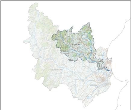 The
Tūtaekuri catchment is 83,105 hectares and includes Puketapu as well as a
number of other small settlements. The Tūtaekuri River forms part of the
boundary between Napier City and Hastings District. Three marae are closely
connected to the Tūtaekuri: Waiōhiki, Timikara and Moteo Hamuera (Timikara
and Moteo Hamuera Marae are in the Ngaruroro catchment but are on the banks of
the Tūtaekuri).
The
Tūtaekuri River begins in native vegetation high in the Kāweka Range
and then passes through commercial pine forest as a clear, fast flowing rocky
river. The river has good quality habitat for most of its length with a regular
occurrence of riffles, pools and bends and a predominantly cobble streambed.
Dry
stock farming dominates the middle catchment although approximately 7000ha of
dairy farming has been established over the last 10-15 years, mostly around Pātoka.
Downstream of the Mangaone River confluence, the Tūtaekuri valley widens
and flattens, and the river takes a more semi-braided morphology. Landuse here
is predominantly vineyards and orchards, with dry stock farming in the
surrounding hills as well as peri-urban/commercial development.
The
Tūtaekuri has been a life source for Ngāti Parau, Ngāti
Hinepare, Ngāti Maahu and Ngāi Tawhao hapū. Valued as a taonga,
the original name of Te Wai o Mahurangi was changed to Tūtaekuri after the
process of preparation of food for travellers from the Wairoa region. The
entrails (tūtae) of animals, which included fresh water mussels, birds,
tuna and dogs (kuri) were cast into the river and carried to the sea. This is
how the river acquired its new name Tūtaekuri (entrails of the dog).
Historically the Tūtaekuri acted as a pathway for travel and trade from
the mountains to the sea. Pā sites along the Awa were fought over many
times, in part due to its prime location and the valuable resources it
provided. Still seen today, Otātara Pā is a sign of how
Tūtaekuri and its people lived side by side. Waiohiki and Moteo are the
predominant Marae along the river today.
The
catchment holds significant ecological value associated with the aquatic and
riparian ecosystems and indigenous fauna and flora. Seven native fish species
with populations which are classified as declining at a national level are
found in the Tūtaekuri and it is an important catchment for lamprey and
koaro.
There
are a number of freshwater wetlands in the catchment which support a wide range
of bird and fish species, the largest being the ecologically significant Lake
Te Rotokare. The lower braided reach of the Tūtaekuri supports a high
population of banded dotterels.
The
catchment supports a significant brown and rainbow trout fishery with good
angling opportunities in the Mangatutu and the Tūtaekuri mainstem. Trout
populations are self sustaining with spawning
occurring in a number of tributaries.
Other
recreational activities in the catchment include tramping, swimming and
kayaking. In the upper reaches, the Donald River is highly valued for
whitewater kayaking while flatwater kayaking occurs in the lower catchment near
Puketapu. Popular swimming locations are found near Puketapu and at Guppy Rd
near Taradale where the recreational grade is recorded as fair due to
occasional bacterial contamination. The lower section of the Tūtaekuri is
fenced to keep cattle out and to support the high recreational value of the
river.
Water quality
HBRC
monitors ecological health and water quality at seven sites in the
Tūtaekuri catchment, of which three are long-term data records covering 20
years of quarterly samples, and four additional sites since 2012. The four
sites on the Tūtaekuri mainstem are Lawrence Hut, upstream of the Mangaone
River confluence at Rissington, Puketapu and Brookfields Bridge. The three
remaining sites are in the two biggest tributaries, the Mangatutu (one) and the
Mangaone (two).
From
2009 SOE reporting, most parameters indicate good water quality in the
Tūtaekuri catchment. The microbiological water quality is generally
excellent. Water clarity outside periods of high river flow is generally
excellent at the top of the catchment although declines in the lower catchment.
The generally low ammonia concentrations are unlikely to cause any acute or
chronic toxic effects on the aquatic biota.
The
key issue for the catchment is the common occurrence of nuisance levels of
periphyton (algae) in the lower Tūtaekuri River during extended periods of
low river flows which occur despite the nutrient concentrations being below
recommended guidelines (RRMP guideline for DRP and ANZECC guidelines for SIN).
The Mangaone and Mangatutu Rivers show an increased concentration of nutrients,
particularly DRP, and are likely to be contributing to the excessive periphyton
growths in the Tūtaekuri mainstem. The lower Tutaekuri also exhibits
reduced MCI scores and HBRC is investigating the likely cause of this decline and
the sources of nutrients.
The
2009 SOE report showed no clear indication towards a single nutrient limiting
periphyton growth in the Tūtaekuri catchment, indicating that the
limitation status can potentially switch often and at different flow conditions
during the course of a year. There is only a weak link between river flows and
a trend towards P- or N-limitation. Therefore a single nutrient management
option was not recommended for managing periphyton growth in the Tūtaekuri
catchment.
It
is anticipated that 2014 SOE reporting will identify the sources of nutrients,
and clarify the nutrient limitation status of the river during periods of
active algal growth.
Water quantity
HBRC
monitors water flow in the Tūtaekuri catchment at three sites: Lawrence
Hut, Brookfields Bridge and the Mangaone River at Rissington. Most surface
water takes are linked to the 2800 l/s minimum flow at Ngaroto Rd. This minimum
flow provides greater than 90% habitat retention for longfin eel, rainbow trout
and torrentfish.
Security
of water supply is excellent with the approximately 100 consent holders in the
catchment never having been subject to low flow restrictions. There may be
scope for granting additional water permits but this will need to take into
account other potential changes to the flow regime (e.g. groundwater / surface
water connectivity).

Tūtaekuri
– interim agreements
33. The TANK Group is concerned about the
excessive periphyton growth in the lower Tūtaekuri and requests that HBRC
investigate and report back to the Group on causes of these growths and
possible measures to reduce them.
34. The TANK group will consider whether to
recommend confirming or amending the existing minimum flow and allocation.
9.2. Ahuriri
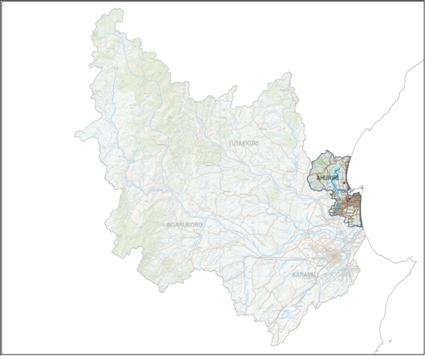 The
Ahuriri catchment is 14,564 hectares and includes Napier and surrounding
suburbs north to Bay View and south to Awatoto. Wharerangi and Te Maara Marae
are in the catchment. The catchment includes a number of urban and peri-urban
streams as well as the Ahuriri Estuary.
The
Ahuriri catchment is 14,564 hectares and includes Napier and surrounding
suburbs north to Bay View and south to Awatoto. Wharerangi and Te Maara Marae
are in the catchment. The catchment includes a number of urban and peri-urban
streams as well as the Ahuriri Estuary.
Because of
the nature of the Ahuriri catchment, the most significant freshwater management
issues are urban-based. The Napier City stormwater network which protects the
urban and industrial areas from flooding generally flows into the Ahuriri
Estuary, a site of ecological, cultural and recreational significance. Despite
extensive modification, reclamation, drainage, and discharges from the
stormwater network, the estuary is recognised as a regionally and nationally
significant area with high wildlife and fisheries values. In the Regional
Coastal Environment Plan, the Ahuriri Estuary is classified a Significant
Conservation Area which affords the estuary particular protection mechanisms.
As one of the
few sheltered, tidal lagoon estuaries within Hawke’s Bay, Pandora Pond provides
for a number of recreational opportunities including swimming, kayaking,
sailing, and waka ama. On an exposed coastline such as Hawke’s Bay, this is an
important area for contact recreation and is one of the highest profile uses of
the estuary, along with bird watching.
The
seven hapū of Mana Ahuriri have a long-standing cultural connection with
Te Whanganui a Ōrōtū (of
which Ahuriri Estuary is a part) where they have resided since well before
European settlement (likely to be as far back as 12th century AD).
Historically this area was a main source of food for the hapū. There are
also a large number of wāhi tapu
in the area. The timing of their negotiations with the Crown to settle their
Treaty claim has the parties signing an Agreement in Principle in December
2013. Key to their reaching a durable settlement will be the recognition of
their mana in Te Whanganui a Orotū, and the estuary. Mana Ahuriri are seeking
to have their kaitiaki status over the estuary effectively recognised, and to
ensure that there is a coordinated and comprehensive approach to the estuary’s
management involving all stakeholders with management responsibilities and
interests in the estuary. The current proposal is that the Greater Heretaunga
and Ahuriri Plan Change would be required to have regard to an Estuary
Management Plan developed with Mana Ahuriri.
Water quality
HBRC monitors
at two long-term sites in the Ahuriri catchment for the SOE programme: the
Taipo Stream at Church Rd and the Awatoto Drain.
A
comprehensive water quality and ecology study was carried out in 2008/09 which
looked at 13 sites in 7 streams. This study found that most parameters
indicate poor water quality in the Ahuriri catchment. The urban streams in this
catchment are significantly more polluted and macroinvertebrate communities in
significantly poorer health than the rural streams. Some of the industrial
streams show regular exceedances of environmental guidelines for zinc. During
summer, water temperatures in the urban streams regularly exceed 25 C which can
potentially lead to fish kills in the streams if occurring for extended
periods.
Most Ahuriri
streams have elevated nutrient and suspended solid concentrations, with
dissolved phosphorus concentrations being particularly high – always well above
ANZECC and RRMP guidelines. Some of the urban streams such as Saltwater Creek,
Purimu Stream and Cross Country Drain have particularly high phosphorus
concentrations while Georges Drive Drain and Saltwater Creek have elevated
ammoniacal nitrogen and suspended solid concentrations. E. coli concentrations
in the Napier catchment streams are highly variable with very high
concentrations reached in some streams.
Extensive
monitoring is undertaken by HBRC in the Ahuriri Estuary as part of its SOE
monitoring. The estuary is currently classified as being in ‘fair’ condition
for contact recreation. However, elevated bacterial concentrations occur at
times, especially after heavy rain, which can increase the risk of illness for
recreational users.
Clarity is
good in Pandora Pond and nuisance algal growths are rare. Concentrations of
contaminants in estuary sediments are mostly at levels below guidelines,
however sites adjacent to stormwater discharges have shown levels that can
exceed environmental guidelines, and where adverse biological effects can be
expected to occur occasionally.
Current
information suggests that shellfish gathered from the estuary may be unsuitable
for human consumption because of elevated faecal indicator bacteria
concentrations which may stem from stormwater, overland flow or accidental
sewage discharges. The inflow of stormwater derived from urban drains and the
proximity of shellfish beds to these inflows indicate that the estuary should
not be regarded as a safe shellfish resource. Faecal source tracking will help
identify the sources of faecal contamination and assist with targeting
appropriate management strategies.
Toxic metal
contamination of shellfish and fish species is currently not at levels expected
to pose immediate health risks although the indirect effects of contaminants on
the abundance and distribution of edible resources is an area identified for
further investigation.
Water quantity
The major
issue from a water quantity perspective in the Ahuriri catchment is the large
volumes of stormwater as noted in section 7.8. There is only a very moderate
amount of freshwater abstraction for irrigation and there are no minimum flow
limits for review. The groundwater allocation limit which will be set for the
Heretaunga aquifer may impact on the few groundwater abstractors in the
catchment. From a freshwater management regime perspective there a no major
issues which require addressing in the Plan Change.

Ahuriri –
interim agreements
35. The TANK Group considers the Ahuriri Estuary
to be a site of ecological, cultural and recreational significance and
recommends that all reasonable measures are undertaken to support these uses
and values including restoring suitability for food gathering.
36. The TANK Group is concerned about sediment, nutrient,
bacteria and contaminant inputs to the Ahuriri Estuary and requests that HBRC
investigate and report back to the Group on sources of these and possible
measures to reduce them.
37. The TANK Group is concerned about poor water
quality in the urban streams and requests that HBRC investigate and report back
to the Group on causes of the poor water quality and possible measures to
improve it.
9.3. Ngaruroro
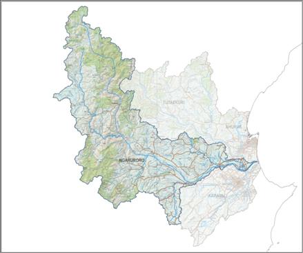 The
Ngaruroro catchment is 201,246 hectares and includes Maraekākaho,
Fernhill, Omāhu and Pākowhai as well other small settlements. There
are five marae in the catchment: Omāhu, Rūnanga, Te Awhina, Timikara
and Moteo (although, as noted in the Tūtaekuri section, Timikara and Moteo
are on the banks of the Tūtaekuri).
The
Ngaruroro catchment is 201,246 hectares and includes Maraekākaho,
Fernhill, Omāhu and Pākowhai as well other small settlements. There
are five marae in the catchment: Omāhu, Rūnanga, Te Awhina, Timikara
and Moteo (although, as noted in the Tūtaekuri section, Timikara and Moteo
are on the banks of the Tūtaekuri).
Beginning
high in the Ruahine Range, the Ngaruroro River is a fast flowing rocky river
through predominantly native vegetation with some pasture down to Whanawhana.
Below Whanawhana down to Maraekakaho, the river is semi-braided, flowing in a
relatively wide and flat channel bordered by steep hill country and high river
terraces. The land use in this part of the catchment is predominantly dry stock
farming with land use changes occurring in the last 15 years. There are two
large intensive dairy operations, one on either side of the Ngaruroro River
downstream of Whanawhana.
Downstream
of Maraekākaho, the river runs through plains and low rolling hill country
and land use becomes more varied including viticulture and cropping. The river
channel is wide and flat, with a low gradient leading to a semi-braided
morphology, constrained on each side by stopbanks. The area is a zone of
groundwater recharge losing approximately 5m3/s, or 20% of its median flow, to
groundwater between Ohiti and Fernhill. The aquifer is of major importance to
the region providing water for multiple uses including irrigation, processing
and industrial use as well as an untreated water supply for Hastings and
Napier. The Ngaruroro River then flows eastwards to an estuary shared with the
Tūtaekuri River. It flows into the Pacific Ocean on the East Coast of
Hawke’s Bay, South of Napier.
Like
the awa, tangata whenua descend from the Ruahine, Kaweka, Kaimanawa ranges. The
connection for tangata whenua with the awa is longstanding, as evidenced by the
marae located beside the awa – Runanga, Te Awhina, Ōmahu,
Kohupātiki. There are two recognised names for the awa. One is Ngaruroro
moko tuararo ki rangatira, given by Ruawharo, one of the tohunga or priests
aboard the Takitimu waka when it arrived in Hawke's Bay hundreds of years ago.
The other is Ngā ngaru ō ngā upokororo meaning “the shoaling
waves of the grayling”, given by the tohunga, Tamatea. Tangata whenua are
acutely aware that this name refers to a fish which is now extinct and, as
tangata kaitiaki, they seek to ensure no further loss of taonga species.
The
Ngaruroro catchment supports a significant brown and rainbow trout fishery. The
angling activity is spread throughout the catchment, with the Ngaruroro
mainstem above the Taruarau confluence and the Taruarau itself the most sought
after fishery. The trout populations in the catchment are self sustaining, with
trout spawning occurring in the mainstem and a number of tributaries.
Recreational
activities occur in many parts the catchment. The Ngaruroro down to Whanawhana
is highly prized for whitewater kayaking particularly around Kuripapango and
flat-water kayaking occurs throughout the river down to the coast. Jet-boating
is popular from Maraekakaho to Whanawhana. Popular swimming locations are found
at Kuripapango, and at Chesterhope and Fernhill Bridges where the recreational
grade is recorded as fair.
The
catchment also holds significant ecological value associated with the aquatic
and riparian ecosystems and indigenous fauna and flora. Significant wetlands
include Lakes Runanga, Ōingo, Hurimoana,
Kautuku and Potaka along with Pig Sty Swamp and Waitangi wetland. These
support a large range of fish and bird species some of which are threatened.
Nineteen native fish species (eight with populations which are classified as
declining at a national level) can be found in the catchment and it is a
stronghold for longfin eel, banded kokupu, lamprey, koaro, dwarf galaxiid and
inanga in the Waitangi Estuary. The upper reaches are a stronghold for whio
(blue duck) and the lower braided reaches support a very high population of
banded dotterels.
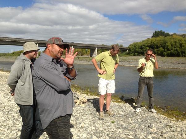
Figure 14: Marei Apatu describing mana whenua connections with
the Ngaruroro River; Field trip, February 2013.
Water quality
HBRC
monitors ecological health, water quality and flow at eleven sites across the
Ngaruroro catchment. Seven of these sites are on the Ngaruroro River main stem,
and two on the Waitio and Tūtaekuri-Waimate tributaries. NIWA also
monitors water quality and flow at two sites.
From
2009 SOE reporting, most parameters indicate very good water quality in the
Ngaruroro catchment – better than national guidelines. Nutrient concentrations
are very low in the Ngaruroro at Whanawhana and in the Taruarau at Taihape
Road, increase travelling downstream, but always remain below guideline levels
in the mainstem. Current ammonia concentrations are unlikely to cause any acute
or chronic toxic effects on the aquatic biota. Some periphyton growth occurs at
low flows, especially in the middle and lower reaches during summer.
There
are “hot spots” of excess nutrients in tributaries of the Ngaruroro: the
Tūtaekuri-Waimate and Waitio tributaries have elevated DIN concentrations
and DRP is usually above guideline limits. Data for other tributaries is being collected
for reporting in June 2014, but there is already an indication that nutrient
concentrations in Maraekakaho are in the range of the Waitio and
Tūtaekuri-Waimate, and the Poporangi has the highest nutrient
concentrations of the assessed tributaries, with DRP being generally well above
guideline limits.
There
is no clear indication of one nutrient limiting periphyton growth in the
Ngaruroro River meaning that controlling the inputs of both nutrients is
important. Improved riparian management on these tributaries may assist.
Water
clarity is excellent in the upper reaches but begins to decline fairly high up
in the catchment suggesting that erosion from pastoral and commercial forestry
land above Whanawhana is a contributing factor. Below Whanawhana the decline in
water clarity is gradual, and the cause cannot be narrowed down to a single
factor.
Because
of the variation between reaches of the catchment, including natural features
and resource pressures, the TANK group consider that water quality in the
Ngaruroro should be addressed by looking at the upper, middle and lower reaches
and Waitangi estuary separately.
Water quantity
HBRC
monitors water flow in the Ngaruroro catchment at three sites on the Ngaruroro
mainstem: Kuripāpango, Whanawhana and Fernhill. Most surface water takes
are linked to the 2400 l/s minimum flow at Fernhill. This minimum flow provides
approximately 85% habitat retention for longfin eel, 60% for rainbow trout and
50% for torrentfish.
There
are approximately 250 water take consents in the Ngaruroro catchment, over two
thirds being from groundwater. Most of these consents expire in 2026. Security
of water supply in the Ngaruroro catchment varies depending on crop, location,
type of water take (surface water, groundwater) and consent details
(allocation, minimum flow restriction).
 Ngaruroro – interim agreements
38. The TANK Group considers that management of
the Ngaruroro catchment may be able to be based around four zones: upstream of
Whanawhana; Whanawhana to Fernhill; Fernhill to the coast; and the Waitangi
estuary.
39. Further monitoring and investigations are
recommended to better identify the sources of water clarity degradation and
nutrients in the Ngaruroro catchment.
40. Improved understanding of groundwater and
surface water linkages and stream depletion effects is needed before
adjustments to the existing flow regime can be agreed.
41. The main minimum flow on the Ngaruroro River
(2400 l/s at Fernhill) should be reviewed and assessed for how well it is
providing for in-stream values including ecological, recreational and cultural
values.
42. Any changes to minimum flow and groundwater /
surface water linkage rules need to consider impacts, especially
security of supply and economic impacts, on water abstractors including
irrigators and processors.
9.4. Karamū
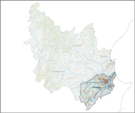 The
Karamū catchment is 51,462 hectares extending south from Awatoto to
Havelock North and west to the Raukawa Range. The
Karamū Stream and its tributaries drain the Poukawa Basin, the
Kohinurakau, Kaokaoroa and Raukawa Ranges and a large part of the Heretaunga
Plains.
The
Karamū catchment is 51,462 hectares extending south from Awatoto to
Havelock North and west to the Raukawa Range. The
Karamū Stream and its tributaries drain the Poukawa Basin, the
Kohinurakau, Kaokaoroa and Raukawa Ranges and a large part of the Heretaunga
Plains.
The
catchment covers the majority of the Heretaunga Plains which has been developed
extensively for agriculture and comprises some of the most productive cropping
areas in New Zealand. The Karamū catchment is the
predominant region in Hawke’s Bay for orcharding, cropping, and viticulture
while the southwestern half of the catchment primarily supports dryland sheep
and beef with the exception of the Poukawa Basin, which is a significant
cropping area.

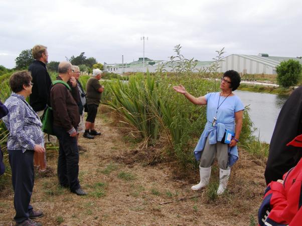
Waterways
in the Karamū catchment have been extensively modified for flood
protection purposes. The current Karamū Stream was once a former course of
the Ngaruroro River, until 1867 when a large flood changed the course of the
river. Flooding of the productive, southern area of the Heretaunga Plains has
been an issue since the time of settlement. In 1969, as part of the Heretaunga
Plains Flood Protection scheme, the Ngaruroro River was diverted to the north,
leaving the Karamū and Raupare streams to feed the lower Karamū Stream
or, as it is also known, the Clive River and Ngaruroro Tawhito (the ‘old’
Ngaruroro).
There
are twelve marae in the Karamū catchment: Kahurānaki, Houngarea
(Mawhai), Mihiroa, Tarāia, Mangaroa, Korongatā, Te Aranga o
Heretaunga, Te Awao te Hauora, Waipatu, Ruahāpia, Matahiwi and
Kohupātiki. Specific concerns of all marae and hapū are being
documented and will be the focus of ongoing work. Ngāti Hori ki
Kohupātiki have well documented concerns as reported in the Ngāti
Hori Freshwater Management Plan. Prior to the 1969 diversion, the Ngaruroro was
very much part of daily life for mana whenua and was a major mahinga kai for
fish, waterfowl and plants. Kohupātiki Marae, one of the Ngāti Hori
marae, is situated on the true left bank of the lower Karamū Stream /
former Ngaruroro and Ngāti Hori ki Kohupātiki’s knowledge of the awa
and the species it supports comes from an unbroken and ongoing relationship
lasting hundreds of years. Today, the area is highly modified and indigenous
biodiversity is scarce. Taonga species such as pātiki and matamata, which
once thrived in the area, have been mostly lost. Ngāti Hori is concerned
about the continued deterioration of the Karamū River and decline in their
customary fisheries, especially the pātiki which are fundamental to the
identity of Kohupātiki as a marae. There are, however, areas of riparian
vegetation in the upper reaches of this sub catchment which provide increased
habitat quality for aquatic communities. Longfin and shortfin eels, as well as
the non migratory Crans bully and upland bully have been collected in fish
surveys.
There
are a number of freshwater wetlands in the catchment which are ecologically
significant, the largest being Lake Poukawa and Pekapeka Swamp. They support a
significant number of bird species, some of which are threatened.
Water quality
HBRC
monitors water quality at eight long-term SOE sites across the Karamū
catchment in the Poukawa, Karewarea, Mangarau (2 sites), Herehere, Ruahapia,
Awanui Streams and the Clive River. An additional short-term concurrent gauging
programme with water quality samples was carried out at 14 sites in 2010.
Lowland
streams with close connection to the sea are an important habitat for many
native fish species, yet poor water quality and loss of habitat can greatly
reduce this value. Water quality and ecology in the Karamū Stream system
is relatively degraded compared to other catchments in the region. Water
quality in the Karamū catchment is generally poor with a high level of
total nitrogen (TN), nitrate-nitrogen (NO3) and particularly high levels of
total phosphorus (TP), and soluble reactive phosphorus (SRP).
Dissolved
oxygen measurements show large variations, with many concentrations being below
recommended guidelines for lowland rivers. Between February and April 2013
extremely low dissolved oxygen levels were recorded – even to complete oxygen
depletion in some streams. Over this period, temperatures stayed fairly low in
some streams, but in others temperatures rose to 26°C. Extreme variability in
temperature and oxygen as well as extremely low oxygen values are a significant
threat to aquatic life. The cause of these extreme conditions has to be
analysed, as several factors like macrophyte proliferation, groundwater influx,
organic load/metabolism, flow conditions or direct sunlight are influencing
temperature and oxygen conditions.
The
Karamū system has a very poor macroinvertebrate community, indicating a
low life supporting capacity but the main drivers for this have yet to be
determined. Stream Ecological Valuation studies carried out in 2010 and 2011
suggested that enhancement of riparian vegetation was a management option that
biotic values would most benefit from.
Some
streams in the Karamū catchment show high levels of E.coli concentrations
which is likely to be contributing to very poor recreational water quality
recorded in the Clive River at the Boat Ramp.
Clarity
is low but the Karamū streams show acceptable compliance with guidelines
and the sites generally comply with guidelines for suspended solid
concentration except in a few reaches.
It
has to be determined what the main drivers are for these conditions, in order
to be able to suggest management options. As the Karamū catchment mainly
consists of lowland type streams, with many of them being groundwater fed,
characteristics are naturally different from most of the Tūtaekuri and
Ngaruroro catchments. For example, macrophyte proliferation, which can cause
oxygen deficiency at night, occurs typically in slow flowing, lowland streams
with infrequent flushing flows like the Karamū and requires different
management than periphyton cover. The control of dissolved nutrient
concentration is not considered to be appropriate for the management of
macrophytes in streams with low levels of physical disturbance whereas
macrophytes are highly dependent on light availability, stream bed substrate
and flow velocity. This could lead to other management options like riparian
management to shade out the plants, which would also help to enhance life
supporting capacity by improving stream habitat.
Water quantity
HBRC
monitors water flow in the Karamū catchment at a range of sites. Like
other catchments, security of water supply varies depending on a range of
factors including location, type of water take (surface water, groundwater) and
consent details (allocation, minimum flow restriction). By far the majority of
the 1200 water takes in the catchment are from groundwater and not subject to
minimum flow restrictions (Figure 16). The green line in the chart is consented
groundwater permits and the red line is surface water.
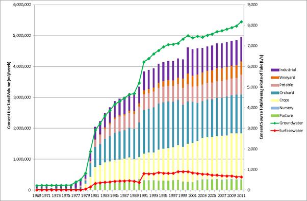
Figure 16: Consented water takes in the Karamū catchment
Improved
understanding of the connection of groundwater with surface flows has seen some
groundwater takes linked to Ngaruroro River minimum flow restrictions where
formerly they were not. This has reduced security of supply for some consent
holders particularly those in the unconfined and semi-confined aquifer zones in
the Twyford region. Other groundwater takes are due to be assessed for surface
water connection over the next two years.
Water
takes linked to minimum flows on some of the smaller tributaries like the
Karewarewa Stream regularly experience water restrictions while larger
tributaries like the Raupare provide a more secure supply.
As
with the other catchments, minimum flow sites and limits in the Karamū
catchment are under review and the connectivity of groundwater with surface
waterways is being investigated. Approximately 200 consents to abstract
groundwater in the unconfined aquifer zone are due to expire in 2019 (the
remainder by 2025) and it is anticipated that the groundwater model being
developed in conjunction with industry and technical experts will help to
inform Plan Change decisions.
 Karamū – interim agreements
43. The TANK Group is concerned about poor water
quality, sediment, excessive macrophytes and lack of riparian vegetation in the
Karamū system and its effects on cultural, ecological and recreational
values including food gathering. The Group requests that HBRC investigate and
report back to the Group on causes of the poor water quality and possible
measures to improved it
44. Improved understanding of groundwater and
surface water linkages and stream depletion effects is needed before
adjustments to the existing flow regime can be agreed.
45. Any changes to minimum flow and groundwater /
surface water linkage rules need to consider impacts, especially
security of supply and economic impacts, on water abstractors including
irrigators and processors.
10. APPENDICES
10.1. Management Variables
The
full list of Management Variables identified by the TANK Group is in the
following table. These have been grouped into three sets: those that will
likely need to be included to meet both HBRC and stakeholder objectives from
the TANK process (green); those that could be done by HBRC if needed to meet
the objectives (orange); and those that other parties could offer as part of a
package to achieve those objectives (blue).
|
Measures
likely to be needed in the TANK process
|
Flow
regime
|
|
Water
allocation (including for municipal and domestic supply)
|
|
Security
of water supply setting
|
|
Policies,
rules on groundwater /surface water connectivity
|
|
Surface
water and groundwater quality limits
|
|
Tangata
whenua involvement in freshwater decision making
|
|
Use
of Matauranga Māori in monitoring and reporting
|
|
Wahi
tapu register
|
|
Policies,
rules and incentives on: riparian management & stock exclusion; water
storage; water efficiency; water sharing/ transfer; nutrient loss/
allocation; good irrigation practices; stormwater management; other
agricultural practices
|
|
Measures
that could be included in the TANK process
|
Rules
to protect wetlands
|
|
Terrestrial
predator control policy
|
|
Incentives/funding
by HBRC
|
|
Education/technical
assistance by HBRC
|
|
Fish
barrier removal
|
|
Rules
on good forestry practices
|
|
Gravel
extraction/raking for flood protection
|
|
Stopbank
management
|
|
HBRC
river access policy (with DoC)
|
|
Weed
management practices
|
|
Hazard
identification and risk management in built environment
|
|
Rules
on discharge of organic/animal waste
|
|
Rules
on toxic discharges
|
|
Rules
on cumulative effects of septic tanks
|
|
HBRC
policies on audited self-management
|
|
Auditing
of farms for compliance/mgmt practice
|
|
Appropriate
land use for type of land
|
|
HBRC
decrease compliance costs
|
|
Help
tangata whenua involved in freshwater governance
|
|
Communicate
opportunities to participate in freshwater governance
|
|
Increase
HBRC knowledge of Mauri of freshwater and coastal resources
|
|
Help
tangata whenua increase capacity to fulfil kaitiaki roles
|
|
HBRC
liaise with mana whenua, e.g. On consent applications
|
|
Things that
other parties could do
|
Industry
initiatives
|
|
Maintain
stormwater retention ponds
|
|
Create
freshwater reserves
|
|
Community
initiatives for education
|
|
Stormwater
rubbish control
|
|
Finance
and promote reticulated community water schemes
|
|
Promote
rainwater collection systems on individual properties
|
|
Territorial
authority initiatives for education
|
|
Install
household water meters
|
|
Territorial
authority policies on water efficiency
|
|
Industry
audited self-management
|
|
Reuse
of grey water
|
10.2. Glossary
Aquifer: An underground
deposit of water-bearing sand, gravel or rock capable of yielding supplies of
water.
Catchment: The total area
draining into a river, reservoir or other body of water.
Community water storage: storage
and distribution networks designed to supply water for more than one person
ranging from small on-farm storage to large scale
community-wide storage.
Ecosystem: A system formed by
all plants, animals, and micro-organisms in a particular area interacting with
the non-living physical environment as a functional unit.
Farm: In this report includes any land based activity for the production
of food and fibre such as forestry, orchards, vineyards, cropping etc.
Farm management plan: A plan to integrate the farm business within the physical
capability of the farms land and water resources. May include separate policies
on the management of irrigation, effluent, fertiliser, riparian and soils.
Industry Good Practice (IGP): a
quality assurance programme that provides a traceable, accountable system from
crop to customer.
Kaitiakitanga: guardianship or
caretaker role (in particular, of natural resources).
Mahinga kai: food gathering
places, cultivated gardens.
Mana: prestige,
authority, status, spiritual power (e.g. of water)
Mana whenua: those who descend
through a hapū or ancestor who hold the tikanga or customary rights over a
specific area.
Mātauranga Māori: Māori
knowledge originating from Māori practices, observations, science,
ancestors, including the Māori worldview.
Mauri: dynamic
inner power and energy from the realm of the creator that emanates outwards
from within provided it is accompanied by rightful action. Mauri comes
from a natural balance, from the spiritual realm before it enters the
natural world and thus only people can harm mauri (e.g. through unsustainable
practices).
MCI –
Macro Invertebrate Community Index: An index of the
proportion of sensitive to tolerant species (in relation to the quality of a
water body), among the community of benthic invertebrates that can be seen with
the naked eye.
Minimum flow: Limits the amount
of abstraction during low river flows. A minimum flow determines when consent
holders have to reduce, and ultimately stop, abstracting.
Nutrient Limitation: The capacity of nitrogen and/or phosphorus to limit plant or
algae growth.
Periphyton: A group of organisms in aquatic environments adapted to living on
inert stable surfaces such as rocks, cobbles and logs. Organisms include fungi,
bacteria, protozoa and algae.
Primary contact recreation: activities
in which the user comes into frequent direct contact with water, such as
swimming and waterskiing.
RHYHABSIM: River HYdraulics
and HABitat SIMulation; a computer model which predicts how instream habitat
availability for selected species varies over a range of flows.
Secondary contact recreation:
activities that generally have less-frequent body contact with the water, such
as boating and fishing
Stock Exclusion: Any
method or activity that prevents farmed animals from having direct access to a
stream or its margins.
Stygofauna: fauna that live in
groundwater systems or aquifers.
Tangata kaitiaki: those
who undertake a guardianship or caretaker role (in particular, of
natural resources).
Tangata
whenua:
in relation to a particular area, means the iwi or hapū that holds manu
whenua over that area.
Taonga:
treasure, anything highly prized.
Tikanga: customary right,
rule, plan, method.
Wāhi tapu: Sacred site, as
defined locally by the hapū who are the tangata kaitiaki for the wāhi
tapu.
Water allocation limits: The
amount of water available to be extracted from a water source for use (e.g. for
public supply, irrigation etc). The total allocation is limited to protect
in-stream values and provide security of supply to water users.
Water Quality: The chemical and physical attributes of water such as turbidity,
phosphorus and nitrogen concentration, temperature, dissolved oxygen and major
ion concentrations.
Water Quality Limit: A limit identified for a particular water quality variable or
attribute to meet a specific management objective.
Wetland: Permanently or
intermittently wet land, shallow water and land-water margins. Wetlands may be
fresh, brackish or saline and are characterised in their natural state by
plants and or animals that are adapted to living in wet conditions. Wetland
functions include nutrient filtering, sediment trapping, preventing flooding,
carbon sequestration, habitats, recreation, education, cultural value.
Whakapapa: genealogy.
10.3. Key documents and technical reports
Coast and Estuaries
Lamason, A. 2006. Waitangi
Estuary Ecological Monitoring. HBRC Internal Report, EMI 0709, Plan No.
3948.
Madarasz, A. 2006. Ahuriri
Estuary: Environmental Assessment and Monitoring. EMI 06/16. HBRC Plan No.
3872.
Madarasz, A. 2006. Nearshore Coastal
Water Quality in Hawke's Bay. EMI 05/16. HBRC Plan No. 3792
Madarasz-Smith, A. 2008. Estuarine
Ecology Programme: Environmental Assessment of Ahuriri and Porangahau Estuaries
2008. Hawke's Bay Regional Council EMT 08/20, HBRC Plan Number 4061.
Madarasz-Smith, A. 2010. Results
of the Recreational Usage Survey 2010. Hawke's Bay Regional Council. EMT
10/22 HBRC Plan Number 4209
Strong, J. 2005. Antifoulant
and Trace Metal Contamination of Sediments from the Napier Inner Harbour. Prepared
for Hawke's Bay Regional Council. EMI 0511. HBRC Plan No. 3687.
Strong, J. 2006. Antifoulant
and Trace Metal Contamination of Sediments from the Napier Inner Harbour -
Stage Two. Prepared for Hawke's Bay Regional Council. EMI 06/13. HBRC Plan
No. 3863
Groundwater
Dodson, M. 2011. Assessment of
Nitrogen and E. Coli Groundwater Quality in the Hawke’s Bay Region, 2008. Hawke’s
Bay Regional Council Environmental Management Group Technical Report. EMT
10/20. HBRC Plan No. 4204.
Harper, S. 2008. Twyford Consent
Area Technical Report – Groundwater Impact Assessment. Hawke's Bay Regional
Council Environmental Management Group Technical Report. EMT 10/02. HBRC Plan
No. 4170.
Harper, S, 2008. Groundwater Quantity - State of the
Environment - 5 yearly Report - 2003 to 2008. Hawke's Bay Regional Council
Environmental Management Group Technical Report. EMT/10/01. HBRC Plan
No. 4167.
Larking, R. & Baalousha, H. 2008. Nitrate in
Groundwater in Hawke's Bay Region. EMI 0727. HBRC Plan No. 3984.
Minni, G., Cameron, S., Meihac, C., & Zemansky, G.
2010. Steady State Groundwater-Stream Interaction Model for Determination of
the Effects Of Groundwater Abstraction On Spring-Fed Stream Flow in the Lake
Poukawa Catchment, Hawke's Bay. GNS Science Report.
Minni, G., Cameron, S., Meihac, C., & Zemansky, G.
2010. Pseudo-transient groundwater- Stream Interaction Model for
Determination of the Effects Of Groundwater Abstraction On Spring-Fed Stream
Flow in the Lake Poukawa Basin, Hawke's Bay. GNS Science Report.
Reid, D., & Scarsbrook, M, 2009. A review of
current groundwater maangement in Hawke's Bay and recommendations for
protection of groundwater ecosystems. Prepared for Hawke's Bay Regional
Council. NIWA Report No. HAM2009-153.
Hydrology
Christie, R. 2010. Maraekakaho
Stream Minimum Flow - Scientific Evidence. Hawke’s Bay Regional Council
Environmental Management Group Technical Report. EMI 10/25, HBRC Plan No.
4224.
Harkness, M. 2010. Ngaruroro
River High Flow Allocation: June to November Period. Prepared for Hawkes
Bay Regional Council, MWH, Wellington.
Harkness, M. 2010. Ngaruroro
River Flow Naturalisation. Prepared for Hawkes Bay Regional Council, MWH,
Wellington.
Johnson, K. 2008. Ngaruroro
River RHYHABSIM modelling updates. EMI 0816, HBRC Plan No. 4051
Johnson, K. 2011. Lower Ngaruroro
River Instream Flow Assessment. Hawke’s Bay Regional Council -
Environmental Management Group Technical Report. EMT 10/38, HBRC Plan No.
4249.
Lew, D.D.F., et al. 1997. Flow
Naturalisation for Six Hawkes Bay Rivers. Prepared for Hawkes Bay Regional
Council. Opus International Consultants Ltd. EMI 9718, HBRC Plan No. 3636
Waldron, R. 2008. Analysis of Karamū
Catchment Flow Regimes and Water Supply Security under a Range of Water
Allocation. EMT 08/04, HBRC Plan No. 4013.
Waldron, R. et al. 2007. Paritua/Karewarewa
Stream - Hydrology. EMI 0730, HBRC Plan No. 3992
Policy and Planning
Hawke’s Bay Regional Council. 2006. Hawke’s Bay
Regional Resource Management Plan. HBRC Plan No 3881. Hawke’s Bay Regional
Council, Napier.
Hawke’s Bay Regional Council. 2011. Hawke’s Bay Land
and Water Management Strategy. HBRC Plan No 4287. Hawke’s Bay Regional
Council, Napier.
MfE, 2006. Your Guide to the
Resource Management Act, 3rd ed. Ministry for the Environment, New Zealand.
MfE, 2008. National Environmental
Standard for Sources of Human Drinking Water. Ministry for the Environment,
New Zealand.
MfE, 2010. National Environmental
Standard on Ecological Flows and Water Levels: Discussion Document.
Ministry for the Environment, New Zealand.
MfE, 2010. National Policy
Statement for Freshwater Management. Ministry for the Environment, New
Zealand.
Tangata whenua and Mana whenua
Ataria, J., Tremblay,
C., Tremblay, L., Kaukau, M., Kemp, R., Mauger, J., Black, M. 2008. He
Moemoea mō Te Whanganui-a-Orotū: A Vision Plan and Health Assessment
for the Napier Estuary. Landcare Research Contract Report (LC0708/061):
Prepared for Ngā Pae o Te Māramatanga. 77 pp.
Durette, M. 2009. An integrative
model for cultural flows: Using values in fisheries to determine water
allocations. Synexe Working Paper 2009/01.
Durette, M., Nesus, C., Nesus, G.,
& Barcham, M. 2009. Māori perspectives on water allocation. Wellington: Ministry for
the Environment.
Kusabs, I. 2008. An assessment of
fisheries values and comments on the impact of river diversion and potential
for future restoration. Report prepared for Ngāti Hori. Rotorua, New
Zealand.
Ngati Hori. 2013. Ngati Hori
Freshwater Resources Management Plan: Operation Patiki.
Whyte, A., Tiuka, N. 2008. Kahungunu
ki uta, Kahungunu ki tai, Marine & Freshwater Fisheries Strategic Plan; Nga
Tini a Tangaroa o Ngati Kahungunu Iwi Inc.
Values
Booth, K., Bellamy, S., England, A., Hales, W., Kelly,
B., Mahoney, M., Reed, C., & Sevicke-Jones, G. 2012. Whitewater Kayaking
in Hawke’s Bay: Application of the River Values Assessment System (RiVAS), Land
Environment and People Research Paper 12. Lincoln University, Canterbury,
New Zealand.
Booth, K., Coubrough, L., & Winlove, T. 2012. Salmonid
angling in Hawke’s Bay: Application of the River Values Assessment System
(RiVAS), Land Environment and People Research Paper 16. Lincoln University,
Canterbury, New Zealand.
Booth, K., Clode, G., Davis, P., Haidekker, S., Reed,
C., Sharp, T., & Winlove, T. 2012. Natural character in Hawke’s Bay:
Application of the River Values Assessment System (RiVAS and RiVAS+), Land
Environment and People Research Paper 15. Lincoln University, Canterbury,
New Zealand.
Booth, K., Madaraz-Smith, A., Mauger, J., Paipper, A.,
Petuha, E., & Sharp. T. 2012. Swimming in Hawke’s Bay: Application of
the River Values Assessment System (RiVAS and RiVAS+), Land Environment
and People Research Paper 17. Lincoln University, Canterbury, New Zealand.
Hughey, K., Booth, K., Deans, N., and Baker, M. 2009.
River values assessment system (RIVAS) – The method. Draft report. Lincoln
University, Canterbury, New Zealand.
Hughey, K., Cheyne, J.,
Dickson, R., Forbes, A., Hashiba, K., Rook, H., Sharp, T., Stephenson, B.,
& Welch, B. 2012.
Birdlife in Hawke’s Bay: Application of the River Values Assessment System
(RiVAS and RiVAS+), Land Environment and People Research Paper 14. Lincoln
University, Canterbury, New Zealand.
Water Quality and Ecology
Alexander, S. 2011. Recreational
Water Quality in Hawke's Bay: Review of the 2010-2011 Recreational Water
Quality Monitoring Programme. Hawke's Bay Regional Council EMT 11/01, HBRC
Plan number 4257
Aussiel, O. 2009. Water Quality
in the Tutaekuri Catchment: State Trends and Contaminant Loads. Prepared
for Hawke’s Bay Regional Council, Aquanet, Palmerston North.
Aussiel, O. 2009. Water Quality
in the Ngaruroro Catchment: State Trends and Contaminant Loads. Prepared
for Hawke’s Bay Regional Council, Aquanet, Palmerston North.
Aussiel, O. 2011. Effects of
Domestic and Industrial Stormwater Discharges in the Hawke's Bay Region: State
of Knowledge Report. Prepared for Hawke’s Bay Regional Council, Aquanet,
Palmerston North.
Cameron, D 2010. Stream
Ecological Valuation: Upper Karamū Waterways. Prepared for Hawke's Bay
Regional Council, MWH Wellington, MWH Z1800405.
Cameron, F. 2008. Wetland
Monitoring Review: A Review of Hawke's Bay Regional Council's Wetland
Monitoring. Hawke's Bay Regional Council EMT 08/09, HBRC Plan Number 4076.
Cameron, F. 2010. A Report on the
Known Barriers to Fish Passage in Hawke's Bay. Hawke's Bay Regional Council
EMT10/04, HBRC Plan Number 4174.
Flavall, S., R. 2000). Fisheries
Resource Inventory Ngaruroro River. Unpublished. Fish &
Game New Zealand, Hawke’s Bay Region Report.
Forbes, A. 2011. Stream
Ecological Valuation: Ruahapia and Raupere Streams. Prepared for Hawke's
Bay Regional Council, MWH, Wellington, MWH Z1800401.
Haidekker, S. 2009. Kopuawhara
and Opoutama Catchments: Surface Water Quality and Ecology State of the
Environment Report 2009. Hawke's Bay Regional Council EMT 10/09, HBRC Plan
Number 4184.
Lee, A. 1994. Heretaunga
Ecological District: Survey Report of the Protected Natural Areas Programme.
Napier, Department of Conservation: 140
Miskelly, C., Dowding, J., Elliott,
G., Hitchmough, R., Powlesland, R., Robertson, H., Sagar, P., Scofield, R.,
Taylor, G., 2008. Conservatiuon Status of New Zealand Birds. Notornis 55:
117-135.
O’Donnell, C. 2004. River Bird
Communities. Freshwaters of New Zealand. New Zealand Limnological Society
and New Zealand Hydrological Society. 1; 18.1-18.19.
Parrish, G. R. 1988. Wildlife
and Wildlife Habitat of Hawke’s Bay Rivers. Science and Research Series
No. 2. Department of Conservation, Wellington.
Roper, M. 2004. Fisheries
Resource Inventory Tutaekuri River. Unpublished. Fish & Game New
Zealand, Hawke’s Bay Region Report.
Rutherford, K. 2009. Catchment
Sensitivity, Nutrient Limits, Nutrient Spiralling and Forecasting Future
Landuse Impacts in Hawke's Bay. NIWA Report No HAM2009-001
Stansfield, B. 2010. Stream
Ecological Valuations: Selected Sites within the Napier and Heretaunga
Catchments. Hawke's Bay Regional Council EMT 10/19, HBRC Plan Number 4201.
Stansfield, B. 2009. Clive and
Urban Stream Catchments: Surface Water Quality and Ecology State of the
Environment Report 2009. Hawke's Bay Regional Council EMT 09/26, HBRC Plan
Number 4154.
Stansfield, B. 2009. Urban
Streams of the Napier Catchment. Hawke's Bay Regional Council EMT 10/16,
HBRC Plan Number 4198.
Stevenson, B., 2010 Baseline
Study and Assessment of Effects on Braided Riverbed Bird Communities (Ngaruroro
River) Unpublished report for HBRC
Stevenson, B., 2011 Baseline
Study and Assessment of Effects on Braided Riverbed Bird Communities (Tutaekuri
River) Unpublished report for HBRC
HAWKE’S BAY REGIONAL COUNCIL
Maori
Committee
Tuesday 25 February 2014
SUBJECT: Statutory Advocacy Update
Reason for Report
1. This paper reports on
proposals forwarded to the Regional Council and assessed by staff acting under
delegated authority as part of the Council’s Statutory Advocacy project between
20 November 2013 to 4 February 2014.
2. The Statutory Advocacy
project (‘Project 192’) centres on resource management-related proposals upon
which the Regional Council has an opportunity to make comments or to lodge a
submission. These include, but are not limited to:
2.1. resource consent
applications publicly notified by a territorial authority
2.2. district plan reviews
or district plan changes released by a territorial authority
2.3. private plan change
requests publicly notified by a territorial authority
2.4. notices of
requirements for designations in district plans
2.5. non-statutory
strategies, structure plans, registrations, etc prepared by territorial
authorities, government ministries or other agencies involved in resource
management.
3. In all cases, the
Regional Council is not the decision-maker, applicant nor
proponent. In the Statutory Advocacy project, the Regional Council is purely
an agency with an opportunity to make comments or lodge submissions on others’
proposals. The Council’s position in relation to such proposals is informed by
the Council’s own Plans, Policies and Strategies, plus its land ownership or
asset management interests.
4. The summary plus
accompanying map outlines those proposals that the Council’s Statutory Advocacy
project is currently actively engaged in.
Decision Making
Process
5. Council is required to
make a decision in accordance with Part 6 Sub-Part 1, of the Local Government
Act 2002 (the Act). Staff have assessed the requirements contained within this
section of the Act in relation to this item and have concluded that, as this
report is for information only and no decision is to be made, the decision
making provisions of the Local Government Act 2002 do not apply.
|
Recommendation
1. That the Maori receives the Statutory Advocacy Update report.
|
|

Esther-Amy Bate
Planner
|

Helen Codlin
Group
Manager
Strategic
Development
|
Attachment/s
|
1View
|
Statutory Advocacy Update
|
|
|
|
2View
|
Statutory Advocacy Map
|
|
|
|
Statutory Advocacy Update
|
Attachment 1
|
Statutory
Advocacy Update (as at 4 February 2014)
|
Received
|
TLA
|
Map Ref
|
Activity
|
Applicant/
Agency
|
Status
|
Current Situation
|
|
21 January
2014
|
NA
|
1
|
Application
under Coastal and Marine (Takutai Moana) Act 2011
Nga whanau o Moeangiangi Pt 42N has
made an application for a Protected Customary Rights Order and a Customary
Marine Title Order for an area lying between Waipatiki and Mohaka. This
application is made under section 100 of the Marine and Coastal Area (Takutai
Moana) Act 2011.
|
Nga whanau o
Moeangiangi
Pt 42N
(Wayne T Taylor)
|
Notified
|
4
February 2014
· Public notice
has been given by the High Court that an application has been made. Staff
are currently reviewing the application to determine if it is necessary for
HBRC to join the High Court proceedings.
· Deadline for
joining High Court proceedings is 17 February 2014.
|
|
5 December
2013
|
NCC
|
2
|
Plan Change
10 to the Operative City of Napier District Plan.
A community
driven Plan Change to harmonise district wide provisions between the Napier
District Plan with the Hastings District Plan, incorporate the Ahuriri
Subdistrict Plan and update provisions as a result of recent Napier City
Council policy changes and decisions into the Napier District Plan.
|
NCC
|
Notified
|
4
February 2014
· NCC has
notified Plan Change 10. Staff are currently working through the document to
identify areas that may require a submission from Regional Council.
· Submissions
close on Friday 14 February 2014.
· Previously
informal comments were made by staff on draft content relating to HPUDS and
RPS Change 4.
|
|
8 November
2013
|
HDC
|
3
|
Proposed
Hastings District Plan
Review of the
Hastings District Plan in its entirety. Includes the harmonisation of
district wide provisions between the Napier District Plan with the Hastings
District Plan where relevant..
|
HDC
|
Notified
|
4
February 2014
· HDC has
notified the Proposed Hastings District Plan. Staff are currently working
through the document to identify areas that may require a submission from
Regional Council.
· Submissions
close on Friday 14 February 2014.
· Previously
HDC released a Draft District Plan Review on which the Regional Council
provided comments. Various informal comments were made by staff on draft
content, particularly relating to natural hazards, HPUDS and RPS Change4,
riparian management.
|
|
1 August 2013
|
NA
|
4
|
Application under
Coastal and Marine (Takutai Moana) Act 2011
Rongomaiwahine has made an
application for a Protected Customary Rights Order and a Customary Marine
Title Order in the general Mahia Peninsular area under section 100 of the
Marine and Coastal Area (Takutai Moana) Act 2011.
|
Rongomaiwahine
(Pauline Tangiora)
|
Notified
|
8
November 2013.
· Council has
opposed the grant of the orders unless the nature and geographical extent of
the orders is specified with sufficient detail to enable the Council to
appropriately understand the effect of the orders sought.
|
|
Statutory Advocacy Map
|
Attachment 2
|
HAWKE’S BAY REGIONAL COUNCIL
Maori
Committee
Tuesday 25 February 2014
SUBJECT: Minor Items Not on the Agenda
Reason for Report
This document has been
prepared to assist Committee members note the Minor Items Not on the Agenda to
be discussed as determined earlier in Agenda Item 6.
|
Item
|
Topic
|
Councillor/Committee
member / Staff
|
|
1.
|
|
|
|
2.
|
|
|
|
3.
|
|
|
|
4.
|
|
|
|
5.
|
|
|