Meeting of the Environment and Services Committee
Date: Wednesday 14 August 2013
Time: 9.30 am
|
Venue:
|
Council Chamber
Hawke's Bay Regional Council
159 Dalton Street
NAPIER
|
Agenda
Item Subject Page
1. Welcome/Notices/Apologies
2. Conflict of Interest Declarations
3. Confirmation of Minutes of the
Environment and Services Committee held on 12 June 2013
4. Matters Arising from Minutes of the Environment and
Services Committee held on 12 June 2013
5. Action Items from Meetings
6. Call for General Business
Decision Items
7. Notice of Motion: Cr M Douglas
Information or Performance Monitoring
8. Open Spaces Projects and Funding
9. Verbal Update on Oil & Gas Exploration Discussions
Throughtout Hawke's Bay
11am
Peter Winder presentation:
Potential Costs and
Savings of Local Government Reform in Hawke’s Bay Report
10. Verbal Update on the Tukituki Water Permit Renewal Process
11. Verbal Update Coastal Water - Science Team
12. Statutory Advocacy Update
13. General Business
HAWKE’S BAY REGIONAL COUNCIL
Environment
and Services Committee
Wednesday 14 August 2013
SUBJECT: Action Items from Meetings
Introduction
1. Attachment
1 lists items raised at previous meetings that require actions or
follow-ups. All action items indicate who is responsible for each action, when
it is expected to be completed and a brief status comment. Once the items have
been completed and reported to Council they will be removed from the list.
Decision
Making Process
2. Council is required to make a decision in accordance with
Part 6 Sub-Part 1, of the Local Government Act 2002 (the Act). Staff have
assessed the requirements contained within this section of the Act in relation
to this item and have concluded that as this report is for information only and
no decision is required in terms of the Local Government Act’s provisions, the
decision making procedures set out in the Act do not apply.
|
Recommendation
1. That the Environment and Services Committee
receives the report “Action Items from Previous Meetings”.
|
|

Mike Adye
Group
Manager
Asset
Management
|

Iain Maxwell
Group
Manager
Resource
Management
|
Attachment/s
|
1View
|
Action Items
Spreadsheet
|
|
|
|
Action Items Spreadsheet
|
Attachment 1
|
Actions from Previous
Environment & Services Committee Meetings
12 June 2013
|
Agenda Item
|
Action
|
Person Responsible
|
Due Date
|
Status/Comment
|
|
14 Statutory Advocacy
|
That the HPUDS Implementation
Working Group provides an update to the E&S Committee in light of the
draft changes to the Hastings District Plan and the City of Napier District
Plan.
|
HC/GI
|
Aug
|
HPUDS Implementation WGs next
scheduled meeting is in early September (postponed from 29 July 2013).
|
|
|
|
|
|
|
|
|
|
|
|
|
|
|
|
|
|
|
HAWKE’S BAY REGIONAL COUNCIL
Environment
and Services Committee
Wednesday 14 August 2013
SUBJECT: Notice of Motion: Cr M Douglas
Reason for Report
1. The purpose of this report is to provide
elected members with the formal Notice of Motion received pursuant to Council’s
Standing Orders, Clause 3.10, to be considered at the 14 August 2013
Environment and Services Committee meeting.
2. The Notice of Motion is attached for the
Committees consideration, provided it is moved and seconded.
Notices of Motion
3. The
procedure for a Notice of Motion is dealt with in Council’s Standing Orders.
The relevant portions of the Standing Orders relating to this Notice of Motion
are:
3.10 NOTICES OF MOTION
3.10.1 Notices of motion to be in writing
Notices of motion must be
in writing signed by the mover, stating the meeting at which it is proposed
that the notice of motion be considered, and must be delivered to the Chief
Executive at least 5 clear working days before such meeting.
3.10.2 Refusal of notice of motion
The Chairperson may direct the Chief Executive to
refuse to accept any notice of motion which:
(a) Is disrespectful or which
contains offensive language or statements made with malice; or
(b) Is not related to
the role or functions of the local authority; or
(c) Contains an
ambiguity or a statement of fact or opinion which cannot properly form part of
an effective resolution, and where the mover has declined to comply with such
requirements as the chief executive may make; or
(d) Is concerned with
matters which are already the subject of reports or recommendations from a
committee to the meeting concerned.
Reasons for refusing a notice of motion should be
provided to the proposer.
3.10.3 Mover of notice of motion
Notices of motion may not proceed in the absence of
the mover, unless moved by another member authorised in writing by the mover to
do so.
3.10.4 Alteration of notice of motion
A notice of motion may be altered only by the mover
with the consent of the meeting.
3.10.5 When notices of motion lapse
Notices of motion not moved on being called for by the
chairperson, shall lapse.
|
Recommendations
If the
Notice of Motion is moved and seconded, then:
The
Environment and Services Committee:
1. Receives the Notice of Motion.
Mover/Seconder
CARRIED or LOST
If the
Notice of Motion is received, then:
The
Environment and Services Committee recommends that Council:
2. Agrees
that the decisions to be made are not significant under the criteria
contained in Council’s adopted policy on significance and that Council can
exercise its discretion under Sections 79(1)(a) and 82(3) of the Local
Government Act 2002 and make decisions on this issue without conferring
directly with the community and persons likely to be affected by or to have
an interest in the decision due to the nature and
significance of the issue to be considered and decided.
3. to be
determined at the Committee meeting.
|
|

Liz Lambert
Interim
Chief Executive
|
|
Attachment/s
|
1View
|
Notice of
Motion from Councillor Murray Douglas
|
|
|
|
Notice of Motion from Councillor
Murray Douglas
|
Attachment 1
|
NOTICE OF MOTION for the Council
meeting July 31 2013.
1. THAT given
the general guidance of this council to remove stock from riparian strips and
conscious that Tukituki River Catchment Plan Change 6 will require and enforce
stock exclusion under certain circumstances covered by Plan Change 6, this
Council shall forthwith cease all council initiated action for stock to be
grazed in council owned riparian strips immediately or where no contract
exists, progressively where termination notice shall be given.
2. THAT staff
report to the next council meeting listing any grazing contracts remaining, the
date of issue of such a contract and the date of termination.
Murray Douglas
Councillor
EXPLANATION.
Water quality – as
much as the significant emphasis in this council on water quantity- is a major
policy issue of this council. Stock in and near waterways contribute to water
quality degradation and also minimise the nutrient screening benefits of
vegetation. Notwithstanding this obvious advantage it is incumbent of the
council to show leadership guidance to the framing industry by removing stock
from these riparian margins which generally have already been fenced and
council is deliberately permitting stock inside the fence with resultant water
quality risks.
I have discussed
this with a number of staff and councillors over some time in regard to the
stock in the Karamu Stream that graze intermittently throughout the year and
even now in mid-winter with obvious pugging and water quality issues. I have
been given no convincing explanation why council permits this practice and no
convincing explanation as to how council can suggest and guide good land use
rules for stock exclusion and then deliberately allow it on land it controls.
I am
conscious that in Rule TT1 of Plan Change 6, there is provision for grazing
within the permanently fenced riparian margin for ‘grazing…for weed control
purposes’ providing that this grazing does not exceed 7 days and only once
between the period 1 November to 30 April. I remain unconvinced about this
option as well but if in the debate a reasonable explanation can be provided
why council should allow a variation I may be amend the Notice.
HAWKE’S BAY REGIONAL COUNCIL
Environment
and Services Committee
Wednesday 14 August 2013
SUBJECT: Open Spaces Projects and Funding
Reason for Report
1. Council requested a
report on open spaces, including:
1.1. How much money is
available
1.2. The costs of ongoing
maintenance and enhancement of existing assets/areas
1.3. Options to consider
for further/future investment
1.4. An assessment of
options against the Assessment Criteria to provide priorities for funding from
the remainder of the budget.
2. This paper provides
Council with an update on these Regional open space issues.
Background
3. In recent years open
space investments have been funded through the Regional Community Fund. The
background and current situation with this fund is included in this report.
4. Open space areas of
activity addressed in this report include:
4.1. Regional parks and
reserves network
4.2. Pathways.
Regional
Community Fund
5. On 6 March 2008 Council
resolved to establish a $7.5m borrowing facility for the purposes of funding
projects identified in Council’s Open Space programme and also to fund capital
projects of regional significance under the Community Facilities Fund criteria.
6. A number of additional
projects have been approved by Council on 25 November 2009 and 21 September 2011
and 23 November 2011 for funding under this facility. Of those approved a
number have now been completed.
7. Funding for all
projects was approved at Council meetings.
8. The status of the
borrowing facility is set out in the following table.
|
Details
|
$
|
$
|
|
Total Approved Facility
|
|
7,500,000
|
|
Loans already drawn down
|
|
|
|
Open Spaces
|
|
|
|
Weka Camp
|
30,000
|
|
|
Te Mata Trust Board feasibility study contribution
|
25,000
|
|
|
Te Mata Trust Board design contribution
|
50,000
|
|
|
Tukituki River nutrient wetland development
|
226,000
|
|
|
Clifton Beach rubble removal
|
49,000
|
|
|
Waimarama Domain contribution
|
300,000
|
|
|
Tutira Study
|
15,000
|
|
|
Pathways – Water and Landscapes ride
|
1,500,000
|
|
|
Winery Ride
|
590,260
|
|
|
|
|
(2,785,260)
|
|
Community facilities
|
|
|
|
Waipawa Town Hall upgrade
|
500,000
|
|
|
Hawke’s Bay Museum – 1st instalment
|
450,000
|
|
|
Hawke’s Bay Museum – 2nd instalment
|
750,000
|
|
|
|
|
(1,700,000)
|
|
Further Commitments made
|
|
|
|
Open Spaces
|
|
|
|
CHB Cycleways
|
100,000
|
|
|
Open spaces review and policy development
|
15,000
|
|
|
|
|
(115,000)
|
|
Community facilities
|
|
|
|
Wairoa Community Centre upgrade
|
500,000
|
|
|
Te Mata Park visitor centre
|
500,000
|
|
|
Regional Sports Park
|
1,100,000
|
|
|
|
|
(2,100,000)
|
|
|
|
|
|
Total remaining funds
|
|
$799,740
|
Regional
Open Spaces
9. Council owned or
administered open space areas include:
9.1. Pekapeka wetland
9.2. Pakowhai Country Park
9.3. Tutira Country Park
9.4. Cycleways/pathways
and horse riding trails constructed on HBRC owned or administered land
associated with flood protection schemes.
10. Other river berm land
associated with flood protection schemes with assets on this land include:
10.1. Waitangi wetland
10.2. Muddy Creek wetland
10.3. Lower Tukituki wetland
10.4. Old Tutaekuri River
bed enhancement
10.5. Harakeke waterway
10.6. Te Karamu enhancement
10.7. Wetlands on the Upper Tukituki
River
10.8. Motorbike recreational
area at Chesterhope
10.9. Model flyers club
runway and facilities at Awatoto
10.10. Public vehicular access
points at 22 locations on the Heretaunga and Ruataniwha plains.
11. All of these areas with
the exception of Tutira Country Park are on land which HBRC owns or administers
as they are on Reserve land mainly set aside for Soil Conservation and River
Control purposes under the Soil Conservation and Rivers Control Act 1941.
Tutira Country Park was purchased by HBRC in the mid 1990’s from the Guthrie
Smith Trust and is now designated as Reserve Land held for Soil Conservation
and River Control purposes.
12. Historically HBRC and
its predecessor organisation the HB Catchment Board has worked with a number of
community groups to enhance these areas for public recreation and enjoyment and
environmental enhancement. In recent years there has been increased focus on
these areas with considerable investment made in their enhancement.
HBRC Open
Space Policy
13. At its meeting in August
2008, Council adopted its current Open Spaces policy, which is attached to this
paper for Councillor information. Attachment 1.
Open Space
Network Plan Development
14. Following a decision of
Council at its December 2012 meeting, staff are well advanced in the
development of an Open Space Network Plan for HBRC open spaces.
15. Currently Hawke’s Bay
doesn’t have a formally established and branded network of Regional Parks with
each of the open space areas considered a separate entity. The purpose of the
Open Space Network Plan is to align the vision and management of these spaces
using a Regional Park Network approach. The goal is to provide for more
strategic development and management of HBRC open space areas and assets that
balances environmental protection or enhancement with recreation and community
use.
16. With that in mind, the
following vision has been proposed for the Regional Parks Network.
16.1. “To create a network
of Regional Parks that are accessible, healthy, well cared for and
characteristically Hawke’s Bay; providing space for people to appreciate and
enjoy the outdoors, nature and life.”
17. Staff expect to complete
the development of a draft of this plan later this calendar year and present it
to Council for consideration.
Current
Maintenance Budgets
18. Maintenance budgets for
the various open space areas are included in HBRC annual plans. It is proposed
that these budgets be reviewed when management plans for the individual open
space areas are developed. Current budgets, while adequate for basic
maintenance of the open space areas and facilities, are insufficient for
ongoing development of the areas or renewal of assets.
19. HBRC development of the
pathway network on its land, environmental enhancement of waterways within the
Heretaunga Plains Scheme area and Pekapeka wetland project, has resulted in an
increase in public interest in this area of HBRC work. This has been
demonstrated through the recent HBRC awareness and satisfaction survey, the
results of which were presented to Council at the 31 July meeting.
20. A uniform and consistent
standard of maintenance across all open space assets has not been adopted.
Staff propose that options for levels of service and associated budgets for
each of the open space facilities is set out for Council consideration as
individual management plans are developed. Arrangements can then be
formalised to ensure all park assets and infrastructure are maintained in a
serviceable state and to a standard that is consistent with park values as
identified in the individual park plans and within the proposed Regional Parks
Network Plan.
21. Staff have yet to
complete an exercise of estimating open the value of assets established within
the open space areas and facilities, however preliminary estimates are set out
in the commentary below. Once asset values are known, staff will propose a
depreciation regime for these assets.
22. Future budget
requirements include but are not limited to:
22.1. Maintenance of
signage, car parks, boardwalks, walkways, bridges, roads, tracks, benches,
picnic tables, fences, re-vegetation and amenity plantings, commercial
plantings, and sites of cultural and historical significance.
22.2. Control plant and
animal pests to levels that are consistent with objectives and policies
identified within individual park plans and within the proposed Regional Parks
Network Plan, as well as to ensure that HBRC is a good neighbour to surrounding
land
22.3. Depreciation of Parks
assets to fund asset replacement where required
22.4. Agreed improvement
programmes/works
22.5. Community liaison,
public education, and responding to public enquiry.
Possible
Development
23. Future development plans
for the open space facilities are being considered. Possible development
options will be considered as part of Individual Park Plans as they are
developed. Any possible developments will be designed to compliment and or
enhance park values.
Proposed
Future Directions
24. Individual Park plans
have yet to be developed. Council will be involved in the development of these
plans and will adopt the final plans. The plans will be reviewed and developed
over the next few years.
25. Preliminary staff ideas
for each of these areas are, however, set out below:
Pekapeka Wetland
Park Values
26. A key regional site for
championing environmental awareness and providing educational opportunities.
27. Ecologically significant
– a regionally important wildlife habitat.
28. Culturally significant
with waahi tapu status. Passive recreation site with controlled access.
Vision
29. Continue to restore
ecological function within the wetland through ongoing plant and animal pest
control.
30. Create a northern
walkway and connection with HB trails.
31. Focus on cultural
aspects of the wetland through protecting and restoring pa sites within and
neighbouring the wetland.
32. Continue to realise the
wetlands educational and champion qualities.
Estimated budget requirements if this
were to be achieved
32.1. Maintenance: Increase current budget by 30k per annum (includes 25% ranger
position) (Currently assets are depreciated at $8,000 per year. This is funded
through the project. Staff will review asset replacement values and
depreciation over the coming months).
32.2. Development: Poukawa Stream (Pekapeka to Stock Rd) tree Clearance and re-vegetation
– 100k
Northern walkway
construction and arrival area enhancements - 300k
Pa restoration – 200k
(includes land purchase)
Western wetland
restoration - 50k
Blue Gums revegetation –
50k
Toilet – 15k
Waitangi Wetlands (Including
Tukituki Estuary)
Park Values
33. Ecologically
significant, particularly the coastal zone (boulder bank) from the Tukituki
Estuary to the Ngaruroro estuary and the Muddy Creek wetlands.
34. An important coastal
recreation site for surfcasting, whitebaiting and fish netting, rowing,
canoeing, jet skiing, wind surfing, horse trekking. Part of the regional
cycleway.
35. Some historical
significance.
36. Highly accessible.
Vision
37. Enhance the quality of
the saltwater wetlands and coastal zone through protection of the boulder bank
via plantings and more rigorous vehicle controls. Enhanced predator control
program.
38. Eliminate vehicle
activity within the park (except cycling). Increase active activity (walking)
within the park through enhancing access points and carparks.
39. Integrate the historical
and cultural components of the park more holistically. Educate the public on
the ecological significance of this site.
Estimated budget requirements if this
were to be achieved
39.1. Maintenance: increase budget by 30k per annum (includes ranger / caretaker
position 25%)
39.2. Development: Replace park signage (urgent) – 60k
Repair and Enhance visitor access points
and carparks - 300k
Re vegetation of boulder bank –
100k
Pakowhai Country Park
Park Values
40. Active recreation site.
Dog Walking.
41. High amenity plantings
including native, exotic arboretum and pine plantation.
42. Highly accessible.
Centrally located between city centres and cycleway network.
43. Some historic and
cultural significance (i.e. Old Ngaruroro River channel).
Vision
44. Establish facilities to
better cater for dogs, including balancing dog user needs with those of other
users such as children and school groups.
45. Expand the park to
connect with the Te Karamu enhancement project.
46. Manage potential for
increased public use of the Park and balance that against user enjoyment.
Estimated budget requirements if this
were to be achieved
46.1. Maintenance: Increase budget by 15k per annum (includes ranger/caretaker position
25%)
46.2. Development: Replace park signage –
25k, Park expansion - 150k
Redesign bridge approaches - 50k, Metal main access track and complete lime
path – 25k, Toilet – 15k
Tutira Country Park
Park Values
47. Hawke’s Bays second
largest lake that provides opportunities for camping, fishing, walking and
education.
48. Culturally significant
with areas of Waahi Tapu status.
49. An important soil and
ecological conservation area, including a wildlife refuge.
50. Long term issues with
water quality.
Vision
51. Showcase appropriate
land use and water management through well managed forestry and farming
operations, soil conservation plantings, riparian management and alternative
land uses.
52. Enhance recreational and
educational opportunities, particularly camping, walking, fishing and outdoor
education through joint management with key partners (DOC, MTi, Guthrie Smith
Trust).
53. Increase profile of the
cultural significance of the Lake where appropriate through interpretive
signage and well considered development and protection.
54. Enhance the amenity of
the Lake and Park through riparian restoration around the lake and effective
plant pest control on the park.
54.1. Maintain and enhance park
tracking infrastructure.
Estimated budget requirements if this
were to be achieved
54.2. Maintenance: This will be reviewed as part of the review of the Park Management
Plan to be completed during the 2013/14 year.
54.3. Development: Largely signage and tracking 100k.
55. The Park includes
approx. 130ha of commercial pines that are due to be harvested within the next
8 to 10 years. The harvesting of these pines will need to be carefully managed
to minimise increased sediment flowing into the Lake. In addition there will
need to be a well planned replanting programme for the planted areas. The
necessary plans will be completed before the commencement of harvesting and
with costs expected to be met from the harvest proceeds.
56. Approximately 140ha of
high Unique Manuka Factor (UMF) Manuka has been planted on the steeped land
within the park. This land was identified in the original management plan as
being allowed to revegetate with native species. The planting of high UMF
Manuka will enable HBRC to receive an income from this land from the proceeds
of high UMF Manuka honey while the land is largely retired and allow
revegetation of the area with other native species over the next decades.
Hawke’s Bay Trails
57. Hawke’s Bay Trails offer
some 200km of largely flat and easy, off-road riding/ walking surfaces for recreational
and commuter use, with a total cross agency value of $23,000,000. Of this HBRC
is responsible for the maintenance of approx. 92km of lime sand surfaced
pathways with an asset value of approx. $1,600,000.
58. To meet HBRC’s ongoing
maintenance obligation a budget of $140,000 per annum has been included in HBRC
LTP budgets for the next 10 years. This budget is just adequate to undertake
physical maintenance of the pathways. No provision is currently provided for
major flood damage repair costs, depreciation, or for meeting the cost of
overall coordination and promotion of the network to maximise the benefit to
Hawke’s Bay.
59. Staff have made a
preliminary estimate of long term budget requirements for depreciation and
disaster reserve and believe that it would be prudent to set aside approx.
$100k per annum to meet these costs. This should be considered during the
development of the 2015/25 draft LTP.
60. Currently, Hawke’s Bay
Trails are defined by three themed rides:
60.1. Water Ride
60.2. Landscapes Ride
60.3. Wineries Ride.
61. These rides utilise the
assets of HBRC and its key partners to form the trails. The Trail assets are
generally maintained by their relevant owner.
62. The principal issues now
facing Hawke’s Bay Trails are:
62.1. Maintaining current
levels of service going forward including funding
62.2. Reviewing maintenance
methods and techniques to accommodate any changes
62.3. Budgeting for replacement
costs
62.4. Marketing and promotions
including funding
62.5. Potential impacts of
changes in local governance.
Governance
63. Hawke’s Bay Trails
Steering Group (HBTSG) was formed in December 2012 to provide effective
governance to the marketing and operational management of Hawke’s Bay Trails.
HBTSG is also an operational requirement of the New Zealand Cycle Trail
Establishment Advisory Board (NZCT) Inc. provides for the governance and
management of the New Zealand Cycle Trail, to which Hawke’s Bay Trails is a
‘Great Ride’ member.
Levels of Service
64. The key goal for Hawke’s
Bay Trails is to:
64.1. Maintain the integrity of
the trail network by reducing the frequency of damage and defects to the
pathway surface and associated assets through an effective maintenance and
inspection programme.
65. A further goal for the
Trails is to:
65.1. Increase patronage of the
trail network - by effective marketing and communication (covered in the
marketing plan).
66. The Trails goals are
supported by the following objectives:
66.1. Repairs of anything
presenting a danger to the public within 1 working day of notification.
66.2. Repairs to serious
defects in the surface of the pavement which may pose a risk to pathway users
within 1 working day of notification.
66.3. Repair of minor damage,
vandalism or defects within 1 week of notification.
66.4. Repair of major flood,
vandalism, defects or other damage within 2 weeks of notification.
66.5. Adherence to Trail
maintenance programme including flexibility to alter regime as required to
achieve levels of service.
Growth Management
67. Essential to the success
of the Hawke’s Bay Trails is the management of growth. This growth can be
separated in to two components, user growth and network growth.
User Growth
68. We expect the popularity
of the Trails to grow over time due to natural and to targeted “marketed”
growth. As the number of users increase, pinch points or stresses may occur in
the network and associated infrastructure and businesses which may eventually
lead to reduced levels of service and overall enjoyment of the Trails
experience.
69. A component of the
Marketing Plan is the management of the levels of service of the business
providers, including capacity issues, although ultimately this is down to the
individual businesses. As has happened with current network expansion, it is
expected that new business opportunities will arise to take advantage of user
growth and network density, thus alleviating some of the issues that may occur
with growth.
70. Track counters have been
installed to record hourly user totals. The counters use a single beam infra-red
system to count the number of objects (walkers, cyclists) breaking the beam.
This data will assist with user growth management and growth predictions.
Network Growth
71. Network expansion is
likely to come from two sources:
71.1. Direct requests from
people, organisations or agencies, where contribution funding could assist HBRC
to realise network growth; and
71.2. The need to increase
Trails capacity to meet current or future demand.
71.3. For example – the Hawke’s
Bay Trails Steering Group and HDC have indicated provisional support for
network expansion of the Water Ride between Fernhill and Chesterhope Bridges
(Ngaruroro River stop banks), with a related paper road connection from
Chesterhope to Taradale. This growth would complement HDC’s proposed
Chesterhope Bridge cycle clip-on and HBRC’s own projected expansion of Pakowhai
Regional Park, and is anecdotally supported by cycle tour operators and
commuter networks. Further to this, the Puketapu Loop, Clive to Clifton
and Marine Parade to Bay View sections of trail are extremely popular, with
HBRC’s need to consider capacity management as Hawkes’ Bay Trails grows in
reputation.
Conclusion
72. This paper has provided
a summary of the Regional Open Spaces programme and an update of funding. Council
approved a loan facility of $7,500,000 in 2008 and approximately 10% of this
remains available for allocation.
73. The focus of the paper
is on the Council owned or administered open space areas. For all the key
areas the values, vision, estimated budgets, maintenance and suggested
developments are presented in the paper.
74. However more detailed
information, and opportunities for input, will be available through the
proposed Regional Parks Network Plan. Detailed development proposals will be
considered as part of individual Park Plans.
Decision Making
Process
75. Council is required to
make a decision in accordance with Part 6 Sub-Part 1, of the Local Government
Act 2002 (the Act). Staff have assessed the requirements contained within this
section of the Act in relation to this item and have concluded that, as this
report is for information only and no decision is to be made, the decision
making provisions of the Local Government Act 2002 do not apply.
|
Recommendations
That the Environment and Services Committee:
1. Receives
the “Open Spaces Projects and Funding” report.
2. Notes that
approximately $800k remains within the $7.5m borrowing facility Council
established in its 2009/19 LTP for community infrastructure and open spaces.
3. Notes that
staff expect to present a Parks Network Plan for Council consideration later
in 2013.
4. Notes that
HBRC has significant financial commitment to maintain existing open space
facilities and as yet the full extent of this commitment is not included in
Council’s annual budgets.
|
|

Mike Adye
Group
Manager Asset Management
|

Liz Lambert
Interim
Chief Executive
|
Attachment/s
|
1View
|
Open Spaces
Investment Policy
|
|
|
|
Open Spaces Investment Policy
|
Attachment 1
|
Open Space
Investment
Policy
(Adopted
by HBRC 27 August 2008)
|
Open Spaces Investment Policy
|
Attachment 1
|
Contents
1. Background.. 2
2. Policy Outline.. 2
3. Evaluation Process.. 3
4. Open Space Investment Policies.. 5
5. Category 1 Priorities for Open Space.. 5
6. Category 2 Priorities for Open Space.. 7
7. Supporting Attributes for Categories 1 & 2.. 9
1. Background
In 2007 the Hawke’s Bay Regional Council commissioned
a review of the provision of public open space in the Hawke’s Bay. The
resulting report (Hawke’s Bay Rural Open Space Study: Resource Assessment[1])
concluded that while the region has a number of public open spaces where the
community can go to recreate, there are some gaps or limitations, particularly
in the near-urban area and in respect of coastal access.
In consideration of the findings of this report, and
having regard to the responsibilities and functions of the Council under Part 2
of the Local Government Act 2002 and Part 4 of the Resource Management Act
1991, the Council has determined that there is sound justification for the
Council to be further involved in the provision of public open space to meet
this and other demands. Council recognises that such spaces can be
multi-purpose and can achieve a number of environmental, social and cultural
outcomes.
It is, however, also understood that involvement in
the provision of open space requires a clear identification and prioritisation
of public open space requirements and for a policy to be developed to guide the
Council in making these assessments – either in the active acquisition of areas
of open space, or as opportunities come to hand.
The following policy document has been prepared on
this basis.
2. Policy Outline
The aim of this policy is to identify the types of
open space that are currently most needed in the region of Hawke’s Bay and
provide a system of evaluation of potential sites that Council may in future
consider purchasing or otherwise securing for public benefit.
The policy has two levels. The first of these
describes open space that will be actively sought by the Council. That
is, where the Council will take the initiative of actively investigating,
funding and purchasing (or otherwise securing public access to) open space of
the relevant description. This is referred to as ‘Category 1’ open space.
The second level is open space that will be passively
sought by the Council. These are areas of open space that may be purchased or
otherwise secured by the Council as opportunity arises and where a good deal
may be on offer at the time. This are referred to as ‘Category 2’ open space
and recognises that while there may be an active programme of procurement
(seeking Category 1 open space) there also needs to be an ability to respond to
unexpected situations and opportunities as they arise.
Category 1 priority open space is:
· Coastal space (with primary focus on
strip access)
· Near Urban
· Ecological
· Aligned with HBRC’s Strategic Goals
Category 2 priority open space includes:
· Outstanding natural features (ONF’s)
· Lakes or other inland open waters
· River access
3. Evaluation Process
A three stage process has been developed to ensure
efficiency and satisfaction of Hawkes Bay Regional Council objectives.
|
|
Stage
|
Actioned by
|
Process
|
|
1
|
Policy categories
|
HBRC staff/ industry expert
|
Factual tests
|
|
2
|
Subjective evaluation
|
HBRC staff/ industry expert
|
Weighted assessment matrix
|
|
3
|
Approval
|
Strategic Committee/Council
|
Submit results of stage 1 and
2 evaluation
|
The first stage of evaluation for all candidate sites
is to determine whether the proposed site fits the description of either
Category 1 or Category 2 open space. Those categories are defined in Sections
5 and 6 of this policy and summarised in Table 1. In order to be considered
further a site must fit one or other of these categories.
Having passed this test the next stage of assessment
is to determine the degree of compliance and the extent to which the
candidate site has other supporting attributes that would count in its favour.
A list of 15 subjective attribute criteria are considered to be the essential
determinates of a good investment opportunity. Each of the 15 criteria will be
evaluated and a weighted assessment determined for each criteria. For this
purpose a point-scoring system has been devised. The scoring system is as set
out in Table 2. The total combined score (the sum of the scoring for all
supporting attributes) is intended to provide a means of comparison between
possible alternative sites. The supporting attributes are described in more
detail in section 7. Set out below are the 15 criteria each having a score
range of 1 – 5 (1= low, 5= high) and each criteria will be given a
predetermined weighting which reflects the relative importance of each criteria
with respect to the type of investment being sought by Council.
Key Attributes
1. Coastal access (proximity to a road-end)
2. Proximity to centres of population
3. Ecological value
4. Linkage to
existing public open space
5. Water quality improvements
6. Recreational value
7. Cultural and Historical value
8. Camping
potential adjacent to water bodies
9. Partnership benefits (with TLA’s, DOC
& community groups)
10. Environmental education opportunity
11. At risk environments (including ecological
risk, flood risk)
12. Iconic
value
Financial Attributes
13. Development costs
14. Maintenance costs
15. Other financial returns
16. Resale potential
|
Score
|
Result
|
|
< 60%
|
Decline
|
|
60% to 65%
|
Further Analysis
|
|
> 65%
|
Proceed
|
If the proposed investment has a score below 60%, once
the projects contribution score is divided by the possible maximum score, the
project will be discounted from further consideration. If the score is between
60 and 65% further specific analysis will be carried out on the project to
determine whether any specific attributes scores can be reconsidered or if
consideration of the financial commitment may improve the project scoring.
Scores over 65% will proceed to the next stage of a more detailed investment
analysis.
4. Open Space Investment
Policies
Policy OS1: Council will provide financial resources and/or
other assistance to actively identify and secure, for public access, use and
enjoyment, such areas as described in this policy document as Category 1
Priorities for Open Space. Candidate sites must comply with one or more of
the Category 1 criteria.
Policy OS2: Council will consider providing financial and/or
other assistance for securing, for public access, use and enjoyment, such areas
as described in this policy document as Category 2 Priorities for Open Space.
Opportunities will be taken as they arise. Candidate sites must fully comply
with one or more of the Category 2 criteria.
Policy OS3: All candidate sites shall be evaluated for
compliance with relevant Category 1 or Category 2 criteria and evaluated
against all of the criteria for Other Supporting Attributes.
5. Category 1 Priorities
for Open Space
The following are Category 1 Priorities for
Open Space:
5.1 Coastal open space –
with focus on:
(a) Securing permanent legal foot
access along the coastal margin where access is currently barred or impeded by
natural obstacles and effectively requires all-tide passage over private land.
The Council’s primary focus is on providing
strip-access. Larger park concepts are not a priority except where supported
by other open space attributes described in this policy.
(b) Clarifying and asserting existing public
access rights where these are currently unclear or in dispute. Legitimate
public access to certain parts of the coast is currently prevented by some
landowners claiming no right of access, and actively preventing access, despite
cadastral evidence of the existence of paper roads or public reserves. Council
will seek a negotiated solution in the first instance and focus on
non-motorised access only.
(c) Safeguarding or re-locating existing coastal
access where coastal erosion, landslides etc. are threatening to make access no
longer viable.
5.2 Near Urban – with focus on:
(a) Providing a near urban country park
with multiple use opportunities. Park will be of a rural nature providing a
minimum number of formal facilities.
(b) Containing a broad
number of environmental aspects, such as water, wetlands, flora and fauna,
wildlife habitat etc.
(c) A location that
encourages maximum use and access by the urban population.
5.3 Ecological –
with focus on:
(a) Land or property that has
significant existing ecological values.
(b) Existing ecological
values will be protected or enhanced by intervention.
5.4 Alignment with
HBRC Strategic Goals – with focus on:
(a) Encompassing the open space and at least 2 other
Council strategic goals.
(b) Provides for the concept of sustainability.
6. Category 2
Priorities for Open Space
The following are Category 2 Priorities for
Open Space:
6.1 Outstanding
Natural Features – where purchase would:
Permanently protect an officially recognised
Outstanding Natural Feature (ONF) in circumstances where existing
private ownership does not already provide adequate long term protection.
6.2 Lake or other inland open
waters – that is:
(a) Within close proximity of a significant population
base.
(b) Suitable for recreational
activities such as water skiing, rowing and other such activities as are
currently restricted to the lower Clive River and Wairoa River, as an example.
(c) Providing habitat for native
wetland plants, birds, fish and insects.
This may be in the form of an artificially created
open water body.
6.3 River access
River access, throughout the Region, is already
generally good. Providing for more public access to rivers is not a priority
but opportunities for securing additional marginal strips and access may be
taken up as part of existing council projects such as flood control and
drainage schemes (as part of the Wairoa, Central and Southern Schemes).
7. Supporting
Attributes for Categories 1 and 2
The following are other supporting attributes for
Category 1 and Category 2 Open Space. All candidate sites must be evaluated
against these supporting attributes in addition to relevant Category 1 /
Category 2 criteria. A positive match with any of these attributes will be
considered to add weight to the case for commitment to a candidate site.
The following are divided in to ‘Key Attributes’ and
‘Financial Attributes’
7.1 Key Attributes
The ideal site will:
(1) Have proximity to
a road-end (for coastal land)
In the coastal area the places where additional public
access will be most valuable is where the public can get to from an existing
road end. Opportunities to create a loop-circuit are also important. As a
guide:
· First priority is for sections of
coastline within 2 km of a road-end, especially where the route allows two
road-ends to be linked, or where a loop-circuit is created.
· Second priority is coastline within 4 km
of a road-end (especially between road-ends or on a return-loop).
· Third priority is coastline greater than
4 km from a road-end.
(2) Have proximity to
a centre of population – with preference for:
As first priority: Areas that can be visited in the course of a 1 – 3
hour total excursion time (including return car travel and on-site activity).
These excursion times should be measured from regional centres and weighted on
a population basis. This weighting favours proximity to Napier-Hastings
(122,000 popn), secondly CHB (13,000 popn) and thirdly Wairoa (9,000 popn).
As second priority: Areas that can be visited in the course of a 3 – 5
hour total excursion time. Same population-based weightings apply.
(3) Contain sites of
ecological significance – specifically:
Regionally significant habitat for vulnerable or
endangered species of native plants, animals, fish or insects, (as supported by
Recommended Area for Protection (RAP) status and/or classification in the IUCN
Redbook Listing of Endangered Species) in situations where the on-going viability
and/or recovery of the habitat or target species will be better served by
public ownership than through continued private ownership of the site.
(4) Provide linkage to other existing open space – whereby either:
(a) Takes maximum
advantage of and uses Council owned land or assets, including appropriate areas
within existing schemes, or
(b) Linkage will be
created and new opportunities for public use and enjoyment that would not
otherwise be possible if the sites were unconnected; or
(c) Linkage will
support other attributes described in this policy.
(5) Have potential for water
quality improvements – whereby:
Planting or natural regeneration will measurably
improve the quality of local surface water by reducing silt run-off or
intercepting excess nutrients in groundwater.
(6) Provide opportunity for a
mix of recreational activities – with preference for:
(a) Opportunity for specific ‘niche’ recreational
activities that are currently under-represented in the region and/or
significantly constrained by access to suitable sites on public land (e.g.
hang-gliding, caving, horse-riding)
(b) Opportunity for the site to be used for a broad,
mixed range of activities that will neither conflict with each other nor
conflict with other attributes (such as ecological attributes) of the site.
(7) Contain sites of
cultural or historical significance – either:
(a) A Category I or Category II listed historic
site from the register of the NZ Historic Places Trust.
(b) A significant historic or cultural site publicly
listed on a district, city or regional council database.
(c) A landmark of recorded and proven
significance in local Maori mythology.
(8) Have camping potential adjacent to water bodies
Each potential site for camping must
be considered on its merits and in consultation with DOC and TLA’s. Key issues
to cover and determine include (1) flood risks, (2) long term operation and
maintenance costs, (3) likely impacts on the viability of existing commercial
camp grounds in the area, and (4) the type of user-charge, ownership and
management structure that would best fit local circumstances (i.e. whether
free, fee-paying, seasonality adjusted, council-owned/run, privately-owned/run,
or council and private partnership). But as a guide:
First priority is for road-access camping sites available over the
summer.
Second priority is for road-accessed camping sites available all
year.
(d) Third priority is for foot-access
camping sites (at least 2 km from a road end) that provide a place of overnight
refuge for longer journeys adjacent to water bodies.
(9) Provide
partnership benefits – whereby:
Partnership intervention will
(1)compliment work and/or policy objectives relating to open space
opportunities of local territorial authorities, the Department of Conservation
or other community groups (2) expand the range of benefits beyond purely
Regional Council interests (3)not compromise or replace any legal requirements
or obligations of TLA’s, Government departments or other agencies.
(10) Provide opportunity for
environmental education – whereby:
The educational component will be consistent with
Regional Council functions, policies and targeted educational programmes.
(11) At risk environments
(Ecological, flood) – whereby:
Ownership or intervention will ensure the long term
protection or enhancement of at risk environments in the Hawkes Bay.
(12) Iconic value – whereby:
Each site or opportunity being considered will be weighted
for any iconic value, uniqueness or any extra factor or feature that can be
identified as being of local, regional or national significance by reference to
relevant Outstanding Landscape reports held by Council or Territorial
Authorities.
Financial Attributes
The ideal site will consider:
(13) Development costs
Development costs, including significant capital
investments are considered and weighted on a case by case basis.
(14) Maintenance costs
Maintenance needs and costs are to be calculated ahead
of any purchase and will be based on the intended use of the site.
(15) Other financial
returns
Other
financial returns may be possible, for example, through leases concessions or
carbon credits. Financial returns are to be calculated as exclusive of future
value for re-sale except where re-sale of part or all of the land-holding will
not compromise the primary public good objectives of the initial purchase.
(16) Resale potential
– whereby:
In the event of a future change of circumstances the
site can be readily disposed of (in whole or in part) at any time in the future
if necessary.
|
Open Spaces Investment Policy
|
Attachment 1
|
Table 1: Minimum Qualifying Criteria for
Regional Council Involvement
OPEN SPACE PROJECT:
PROPERTY COMMENT:
|
Open Space to be actively
sought (“Category 1”)
|
|
|
Coastal Access
|
Qualifies? Yes / No
|
|
Minimum requirements for Council involvement
|
· Coastal strip is currently impractical to
access without crossing private land; OR
· Public access is disputed and needs to be
clarified; OR
· Existing public access is under threat
(e.g. from erosion)
|
|
|
|
Near Urban
|
Qualifies? Yes / No
|
|
Minimum requirements for Council involvement
|
· Is of country park concept with a minimum
number of formal facilities; OR
· Contains a number of environmental
aspects, e.g. water, flora & fauna, wildlife; OR
· Be located to encourage significant use
by urban population
|
|
|
|
Ecological
|
Qualifies? Yes / No
|
|
Minimum requirements for Council involvement
|
· Has significant existing ecological
values; OR
· Existing ecological values will be
protected or enhanced by intervention
|
|
|
|
Aligned with HBRC Strategic Goals
|
Qualifies? Yes / No
|
|
Minimum requirements for Council involvement
|
· Encompasses the open space and at least 2
other Council strategic goals,
· Provides for the concept of
sustainability
|
|
|
Open Space to be passively
sought (“Category 2”)
|
|
|
Outstanding Natural Feature
|
Qualifies? Yes / No
|
|
Minimum requirements for Council involvement
|
· At risk in long term if remaining in
private ownership; AND
· Available at no more than normal market
cost
|
|
|
|
Lake or inland open water
|
Qualifies? Yes / No
|
|
Minimum requirements for Council involvement
|
· Within close proximity of a significant
population base; AND
· Suitable for water skiing & rowing;
AND
· Available at no more than normal market
cost
|
|
|
|
River access
|
Qualifies? Yes / No
|
|
Minimum requirements for Council involvement
|
· Available at significantly below normal
market cost
|
|
Table 2: Attributes
|
|
Key Attributes
|
Score Range
|
Score
|
Weighting
|
Max. Weighting
|
Contribution
|
Maximum
|
|
1
|
Coastal Access
|
1 - 5
|
|
|
10
|
|
|
|
2
|
Proximity to Centres of Population
|
1 - 5
|
|
|
10
|
|
|
|
3
|
Ecological value
|
1 - 5
|
|
|
10
|
|
|
|
4
|
Linkages
|
1 - 5
|
|
|
10
|
|
|
|
5
|
Water quality improvements
|
1 - 5
|
|
|
5
|
|
|
|
6
|
Recreational Opportunity
|
1 - 5
|
|
|
5
|
|
|
|
7
|
Cultural and Historical value
|
1 - 5
|
|
|
5
|
|
|
|
8
|
Camping Potential
|
1 - 5
|
|
|
5
|
|
|
|
9
|
Partnership benefits
|
1 - 5
|
|
|
5
|
|
|
|
10
|
Environmental education
|
1 - 5
|
|
|
5
|
|
|
|
11
|
At Risk Environments
|
1 - 5
|
|
|
5
|
|
|
|
12
|
Iconic value
|
1 - 5
|
|
|
5
|
|
|
|
|
Financial Attributes
|
Score Range
|
Score
|
Weighting
|
Max. Weighting
|
Contribution
|
Maximum
|
|
13
|
Development Costs
|
1 - 5
|
|
|
5
|
|
|
|
14
|
Maintenance costs
|
1 - 5
|
|
|
5
|
|
|
|
15
|
Other financial returns
(e.g. leases, concessions, carbon credits)
|
1 - 5
|
|
|
5
|
|
|
|
16
|
Resale potential
|
1 - 5
|
|
|
5
|
|
|
|
|
Total
Score
|
|
|
|
5
|
|
|
Overall
Score = Total contribution score
Total
maximum score x 100%
|
Decline
|
< 60%
|
|
Further Analysis
|
60 to 65%
|
|
Proceed
|
> 65%
|
HAWKE’S BAY REGIONAL COUNCIL
Environment
and Services Committee
Wednesday 14 August 2013
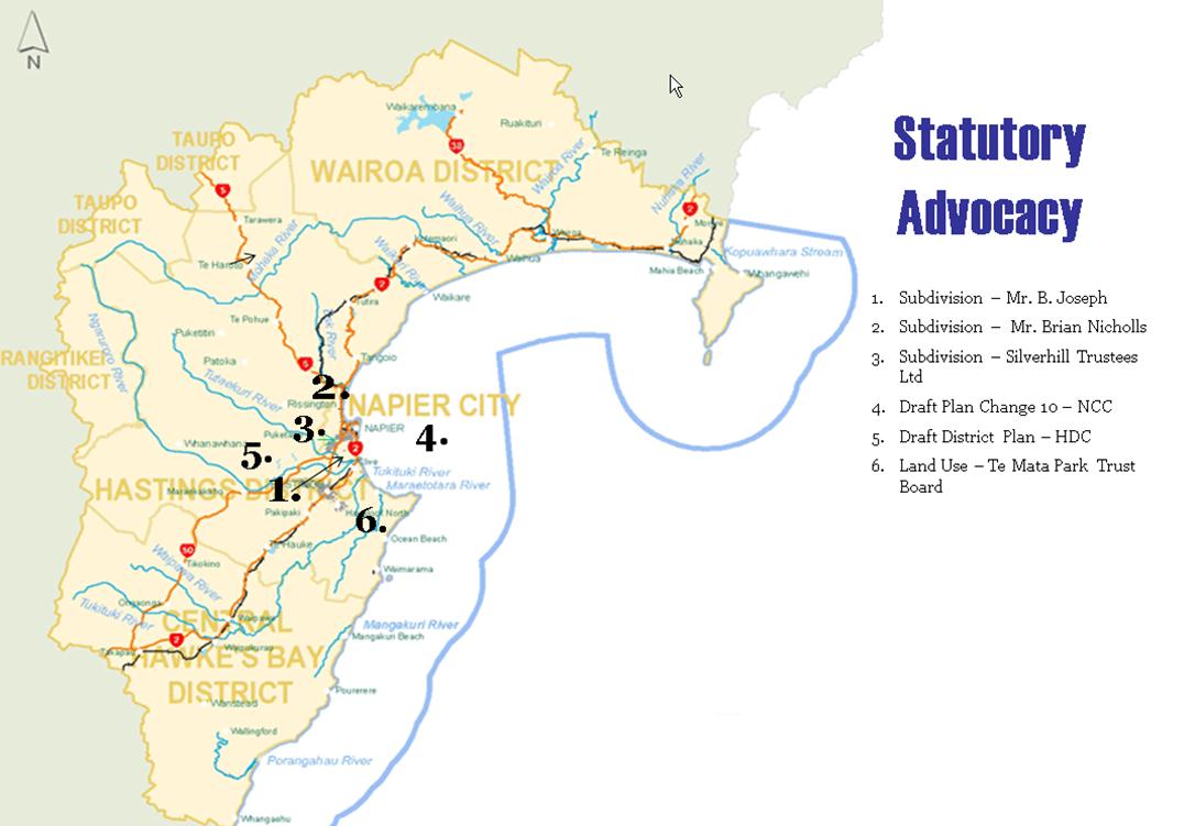
SUBJECT: Statutory Advocacy Update
Reason for Report
1. This paper reports on
proposals forwarded to the Regional Council and assessed by staff acting under
delegated authority as part of the Council’s Statutory Advocacy project between
25 June to 8 August 2013.
2. The Statutory Advocacy
project (‘Project 192’) centres on resource management-related proposals upon
which the Regional Council has an opportunity to make comments or to lodge a
submission. These include, but are not limited to:
2.1. resource consent
applications publicly notified by a territorial authority
2.2. district plan reviews
or district plan changes released by a territorial authority
2.3. private plan change
requests publicly notified by a territorial authority
2.4. notices of
requirements for designations in district plans
2.5. non-statutory
strategies, structure plans, registrations, etc prepared by territorial authorities,
government ministries or other agencies involved in resource management.
3. In all cases, the
Regional Council is not the decision-maker, applicant nor
proponent. In the Statutory Advocacy project, the Regional Council is purely
an agency with an opportunity to make comments or lodge submissions on others’
proposals. The Council’s position in relation to such proposals is informed by
the Council’s own Plans, Policies and Strategies, plus its land ownership or
asset management interests.
4. The summary plus
accompanying map outlines those proposals that the Council’s Statutory Advocacy
project is currently actively engaged in.
Decision Making
Process
5. Council is required to
make a decision in accordance with Part 6 Sub-Part 1, of the Local Government
Act 2002 (the Act). Staff have assessed the requirements contained within this
section of the Act in relation to this item and have concluded that, as this
report is for information only and no decision is to be made, the decision
making provisions of the Local Government Act 2002 do not apply.
|
Recommendation
1. That the Environment and Services Committee receives the Statutory
Advocacy Update report.
|
|

Esther-Amy Bate
Planner
|

Helen Codlin
Group
Manager Strategic Development
|
Attachment/s
|
1View
|
Statutory Advocacy Map
|
|
|
|
2View
|
Statutory Advocacy Update
|
|
|
|
Statutory Advocacy Map
|
Attachment 1
|
|
Statutory Advocacy Update
|
Attachment 2
|
Statutory
Advocacy Update (as at 8 August 2013)
|
Received
|
TLA
|
Map Ref
|
Activity
|
Applicant/
Agency
|
Status
|
Current Situation
|
|
26 April 2013
|
HDC
|
6
|
Resource
Consent – Land Use
To establish
a Visitor Centre and viewing platform comprising of a cafe, theatre, retail,
and education area within a site identified as an Outstanding Natural
Feature.
|
Te Mata Park
Trust Board
Consultant –
Consult Plus Ltd
|
Notified by
HDC Discretionary
|
31
May 2013
· Submission
period closed 24 May 2013
· Council has
provided some funding for the project.
· No submission
lodged.
|
|
10 April 2013
|
HDC
|
5
|
Release of
Draft District Plan
Review of the
Hastings District Plan in its entirety. Includes the harmonisation of district
wide provisions between the Napier District Plan with the Hastings District
Plan where relevant.
|
HDC
|
Draft
(non-notified)
|
31
May 2013
· As a Draft
the document has no legal status yet under the Resource Management Act. The
Draft is precursor to a Proposed District Plan HDC intend publicly notifying
in September 2013.
· Various
informal comments made by staff on draft content, particularly relating to
natural hazards, HPUDS and RPS Change4, riparian management.
· Deadline for
comments is 31 May 2013.
|
|
5 April
2013
|
NCC
|
4
|
Draft Plan
Change 10
A community
driven Plan Change to harmonise district wide provisions between the Napier
District Plan with the Hastings District Plan, incorporate the Ahuriri
Subdistrict Plan and update provisions as a result of recent Napier City
Council policy changes and decisions into the Napier District Plan.
|
NCC
|
Draft
(non-notified)
|
31
May 2013
· As a Draft
the document has no legal status yet under the Resource Management Act. The
Draft is precursor to a Proposed District Plan HDC intend publicly notifying
in September 2013.
· Informal
comments made by staff on draft content relating to HPUDS and RPS Change4.
· Deadline for
comments is 31 May 2013.
|
|
14 February
2013
|
NCC
|
3
|
Resource
Consent – Subdivision
The
application seeks to subdivide and develop an existing site to create a mix
of 17 residential lots and 2 lots to be vested as roads on Oak Road, Poraiti,
Napier.
|
Silverhill
Trustees Ltd
Consultant –
Consult Plus Ltd
|
Notified by
NCC Restricted Discretionary
|
31
May 2013
· Awaiting
further stormwater management details.
· Submission
period closed 15 March 2013.
· Submission
lodged by Council opposing the application due to concerns regarding the site
coverage and stormwater solutions proposed by the applicant.
|
|
24 May 2010
|
NCC
|
2
|
Resource
Consent - Subdivision
The
application seeks to subdivide an area of land currently zoned as Main Rural
on 66 Franklin Road, Bay View into 6 lots and undertake earthworks.
|
Brian
Nicholls
|
Notified by
NCC Restricted Discretionary
(hearing
pending)
|
31
May 2013
· Permitted
Activity status letter issued by Council for discharge of on-site
wastewater.
· Pending
hearing by NCC.
· Previously
HBRC lodged a submission opposing proposal unless all 6 lots were fully
serviced. HBRC staff have had discussions since lodging submission with NCC
and applicant. Discussions focused on stormwater and wastewater design
options for the proposed subdivision.
|
|
23 August
2010
|
NCC
|
1
|
Resource
Consent – Subdivision
The
application seeks to subdivide 58 McElwee Street, Jervoistown Certificate of
Tile HBM2/1351 into two separate lots.
|
Mr B. Joseph
Consultant –
Consult Plus
Ltd
|
Notified by
NCC Restricted Discretionary
(subject to
appeal)
|
31
March 2013
· No further
update. Application on hold pending hearing by NCC re Plan Change 7.
· Previously
HBRC lodged submission opposing proposal. NCC declined consent and applicant
appealed NCC’s decision. HBRC joined appeal proceedings as an interested
party. HBRC’s interests primarily relate to stormwater management and
disposal.
|
HAWKE’S BAY REGIONAL COUNCIL
Environment
and Services Committee
Wednesday 14 August 2013
SUBJECT: General Business
Reason for Report
This report has been prepared to assist
Councillors note the General Business to be discussed as determined earlier in Agenda Item 7.
|
Item
|
Topic
|
Councillor / Staff
|
|
1.
|
|
|
|
2.
|
|
|
|
3.
|
|
|
|
4.
|
|
|
|
5.
|
|
|