Meeting of the Environmental Management Committee
Date: Wednesday 12 October 2011
Time: 9.00am
|
Venue:
|
Council Chamber
Hawke’s Bay Regional Council
159 Dalton Street
NAPIER
|
Agenda
Item Subject Page
1. Welcome/Notices/Apologies
2. Conflict of Interest Declarations
3. Confirmation of Minutes of the
Environmental Management Committee held on 10 August 2011
4. Matters Arising from Minutes of the Environmental
Management Committee held on 10 August 2011
5. Call for General Business Items
6. Action Items From Environmental Management Committee
Meetings
Decision Items
7. Hawke's Bay Land and Water Strategy
8. Update on Taharua Strategy Feedback and Project Review
9. Regional Policy Statement "Built Environment"
Plan Change Update
10. Air Quality Plan Change
11. Plan Change Process for Heretaunga Zone - Integrated
Catchment Management
Information or Performance Monitoring
12. Water Quality Trends in Hawke's Bay 1998-2011
13. Statutory Advocacy Matters
14. General Business
HAWKE’S BAY REGIONAL COUNCIL
Environmental
Management Committee
Wednesday 12 October 2011
SUBJECT: Action Items From Environmental
Management Committee Meetings
INTRODUCTION:
1. On the
list attached are items raised at Council meetings that require actions
or follow-ups. All action items indicate who is responsible for each action,
when it is expected to be completed and a brief status comment for each action.
Once the items have been completed and reported to Council they will be removed
from the list.
DECISION
MAKING PROCESS:
Council is required to make a decision in
accordance with Part 6 Sub-Part 1, of the Local Government Act 2002 (the Act).
Staff have assessed the requirements contained within this section of the Act
in relation to this item and have concluded that as this report is for
information only and no decision is required in terms of the Local Government
Act’s provisions, the decision making procedures set out in the Act do not
apply.
|
RECOMMENDATION:
1. That the Environmental Management Committee
receives the report “Action Items from Previous Meetings”.
|
|

Helen Codlin
Group
Manager
Strategic
Development
|

Graham Sevicke-Jones
acting
group manager
resource
development
|
Attachment/s
|
1View
|
Action Items
from Environmental Management Committee
|
|
|
|
Action Items from Environmental
Management Committee
|
Attachment 1
|
Actions from Environmental Management Meetings
The following is a list of items
raised at Environmental Committee meetings that require actions or follow-ups.
All action items indicate who is responsible for each action, when it is
expected to be completed and a brief status comment for each action. Once the
items have been completed and reported back to the Committee they will be
removed from the list.
10 August 2011
|
Agenda Item
|
Action
|
Person Responsible
|
Due Date
|
Status Comment
|
|
8
|
Draft Growth and
Infrastructure RPS Change
|
HC
|
Oct
|
An update on this plan
change is on the agenda, proposing adoption of plan change for notification
at an EMC meeting to follow the AMB meeting in November
|
|
8
|
Draft Wastewater Plan Change
This item
was left to lie on the table. Councillors wanted more detailed information
about what the options and the costs of those options might be before giving
any indication of the direction they want staff to pursue.
|
HC
|
|
No further work has
taken place with respect to the draft change for strategic management of
onsite wastewater. Will review policy team workloads following notification
of RPS Growth and Infrastructure plan change and receipt of submissions.
Report of April EMC
|
|
13
|
Dairy Inspections –
National Audit
Media release to be
prepared to report Council’s 100% audit compliance
|
DL/GSJ/BL
|
Immed
|
Completed and released
on 15 August 2011
|
15 June 2011
|
Agenda Item
|
Action
|
Person Responsible
|
Due Date
|
Status Comment
|
|
14
|
General Business
Membership of the
Ruataniwha Stakeholder group
There is an apparent
gap in the Tukituki representation on the group, particularly irrigators from
the lower catchment (mid and lower reaches of the river).
|
Graeme Hansen
|
|
This issue is now on
the Ruataniwha project stakeholder agenda and will be addressed through this
process. Shortlisted names are being considered.
|
HAWKE’S BAY REGIONAL COUNCIL
Environmental
Management Committee
Wednesday 12 October 2011
SUBJECT: Hawke's Bay Land and Water Strategy
Reason for Report
1. The purpose of this
report is to present the Hawke’s Bay Land and Water Strategy to the Committee
for its consideration and comment.
2. The Strategy document
evolved following feedback from the External Reference Group on a first draft.
Because the Reference Group are only meeting on the day before the Committee
meeting to review the final document, it has not yet been distributed publicly.
3. Copies will be
available for interested members of the public at the meeting and a media
briefing will also be held during the morning tea break following the
Committee’s consideration of the item.
Strategic Context
4. The Hawke’s Bay Land
and Water Strategy is a document which outlines the strategic direction for the
management of land and water in the region. It is a non-statutory document
which means that it is not required to be prepared by law. However, it enables
the region’s strategic approach to land and water management to be documented
in a way that is not regimented by statutory process.
5. It sets out a range of
actions that are necessary to implement it and while many of the actions fall
under HBRC’s legal responsibilities, there are many other actions which fit
under the mandate of other industry and statutory sector organisations
6. Many of the
actions will need to be implemented through the planning provisions under the
Resource Management Act. This document gives the community an early indication
of how the land and water management framework might change.
Strategy
Development Process
7. The Regional Water
Symposium held in November 2010 began a process of community engagement on
water issues in Hawke’s Bay. The symposium primarily dealt with current and
emerging water quantity issues: allocation (and over-allocation); demand and
supply (mismatches); and competing values – particularly environmental and
economic. Future scenarios for water management and participants’ visions for
Hawke’s Bay were discussed. Land use and water quality was a concern on many
participants’ minds. A Symposium Report
documents the outcomes of the two days.
8. At the symposium,
nominations were sought for an external reference group to work with Council on
the development of policy and directions for a regional water strategy. 92
nominations were received and from this 21 people were selected. The selection
process aimed to ensure fair representation from industry, tangata whenua,
environmental advocacy groups and statutory authorities. On 25 February 2011,
Council agreed on the Terms of Reference for the group.
9. The Hawke’s Bay
Regional Water Strategy External Reference Group held its first meeting on
February 28th and has had five further meetings. The initial intention was to
develop a high level strategy to tackle matters related water quantity in order
to deal with water management issues in manageable chunks. Water quantity was
the focus of the first four meetings.
10. However, land use and
water quality remained a concern and was the topic of discussions during each
of the meetings. In April, the National Policy Statement for Freshwater
Management was released by Government which included a requirement for Regional
Councils to establish water quality targets and limits.
11. By the end of the fourth
meeting, the group was ready to consider a draft strategy document and given
the group’s concern that water quality and land use needed to be addressed,
staff indicated that the draft strategy would cover land use, water quality and
water quantity.
External Reference Group Review
12. The Reference Group has
acted as a sounding board for policy direction and impacts of the policy
changes suggested in the Strategy. They have also advised on the actions needed
to implement the strategy. The reference group is a key building block in
obtaining cross-sector agreement on future water management direction in the
wider Hawke’s Bay community.
13. The Reference Group will
be meeting again on Tuesday 11 October to review this final strategy document.
Comments from that meeting will be given verbally to the Committee at its
meeting the following date.
14. In addition, all members
of the Reference Group have been invited to attend the Committee meeting and
make any further comments that they may like. It will also give an opportunity
for the Committee to ask any questions of the Group.
15. Staff are confident that
we will be in a position that the reference group will collectively endorse the
strategy and will assist Council in taking it to their respective sectors for
discussion.
Contents of the Land and Water Strategy
16. The contents of the Land
and Water Strategy include:
o Introduction, Purpose, Strategy
Development Process
o Drivers of change
o Essential elements of managing land
and water use
o Values, Guiding Principles and
Evaluation Criteria
o Implementing the Strategy – Roles
o Vision
o Six themes relating to:
§ Planning and Governance
§ Sustainable Land Use
§ Sustainable Water Use
§ Information and Communication
§ Priority actions
§ Strategy Outcome and Performance
Monitoring
o Summary of Catchment Values (in
Appendix 2)
17. The objectives for each
theme are:
|
Theme
|
Objective
|
Summary
of approach
|
|
Planning
and Governance
|
Government
Agencies, land owners, tangata whenua and stakeholders work together towards
a unified goal of sustainable land and water management
|
The
development, implementation (with partners) monitoring and review of this
strategy, partnering with tangata whenua, prioritisation of catchments, self
empowering catchment groups, alignment of investments, transparent and equity
in costs of water management, and appropriate transitional provisions.
|
|
Sustainable
Land Use
|
The
future viability and resilience of the wider Hawke’s Bay landscape is
enhanced through improved management and land use practices
|
Focus
on increasing the forest cover on erosion prone hill country, and improving
site specific farming systems to avoid and reduce environmental effects of
intensive farming. Encouraging riparian planting and fencing where
appropriate and recognising the services provided by wetlands.
|
|
Sustainable
Water Use
|
Long
term prosperity of the region is provided through sustainable and efficient
water use while maintaining and/or improving the overall quality of the
freshwater ecosystems for agreed management objectives
|
Identifies
the need for forward thinking and long term decision making then focuses on
water allocation framework, water use, potential water demand and water
quality. The water allocation framework includes recognising interconnected
water bodies, high flow harvesting, promoting flexible allocation regimes,
recognising efficient water use, promoting shared consents and audited self
management for increased efficiency gains and recognising large scale
community storage infrastructure as a critical element of sustainable
solutions in constrained environments.
For
water use the approach focuses on efficient irrigation systems, conservation
and demand strategies for urban and industrial use, measuring water use in a
public transparent way and recognising efficient users.
Water
quality focuses on setting water quality for agreed management objectives,
and targeting action where water quality is poor. Land management and
riparian initiatives are repeated here from the Sustainable Use of Land
section. In addition, exclusion of stock from water ways is actively sought.
|
|
Information
and Communication
|
Relevant
and timely resource information is collected and communicated in a
transparent manner to all interested parties
|
Science
and monitoring data of resource data is available in the public domain and
research is available to land managers
Action
plans to increase community awareness of the value and importance of water
|
|
Priority
actions
|
Actions
are prioritised to areas where sustainable land management, security of water
supply and water quality issues and pressures are most significant or
potential economic gains can be enabled
|
Key
issues are identified on a catchment basis, along with current work
programmes
|
|
Strategy
outcome and performance monitoring
|
Implementation
of the Strategy is monitored and reported on a regular basis.
|
A
number of indicators have been identified in the following outcome areas –
land management practices, water use, water quality and ecological health,
planning instruments and economic development. The implementation structure
of an HBRC team / technical advisory group and the continuation of an
external reference group is proposed to develop action plans, prepare
monitoring reports and review the strategy.
|
Committee’s Review
18. Three Councillors (Crs
Wilson, Scott and Remmerswaal) are members of the Reference Group and have a good
understanding of how this strategy has been developed.
19. The strategy complements
the Council’s Strategic Plan so it does not present new directions for the
Council.
20. Councillors are
encouraged to provide staff with early feedback on the strategy prior to the
Reference Group meeting so that these can be discussed by the Reference Group
as part of their review.
21. In addition, if there
are any significant amendments that the Committee would like to suggest, it
would be worthwhile that these are discussed with the members of the Reference
Group who are at the meeting to get their feedback on them.
Next Steps
22. It is proposed that the
Hawke’s Bay Land and Water Strategy, with any amendments following discussions,
is presented to the Council at the 26 October meeting for adoption.
23. It is proposed that the
Land and Water Strategy will be printed and available in early November.
24. Community engagement
will take the form of a 2nd Symposium (one day) to be hosted by HBRC
on Wednesday 30th November 2011 at the War Memorial Centre. This
will be almost a year to the day from the 1st two day symposium.
25. While specific
invitations will be sent to the invitees and participants of the first
symposium, this event will be open to the public. However, to manage costs, it
will be limited to 150 people.
26. Given the collaborative
process that has been used to develop this Strategy and the level of consensus
achieved between the stakeholders, the Strategy as adopted will be in its final
form. However, the actions are high level and there is still further work
required to identify appropriate mechanisms in many areas and discussion and
feedback from the stakeholders and community in these areas will ongoing.
Financial and Resource Implications
27. The development of the
Land and Water Strategy falls under Project 192 Strategy and Implementation.
Budget is available for the design and printing of the Strategy (quoted $18,900
- $20,500 excl GST) and holding the 2nd Symposium (approx
$10,000.00) based on 150 participants.
Decision Making Process
28. Council is required to
make a decision in accordance with the requirements of the Local Government Act
2002 (the Act). Staff have assessed the requirements contained in Part 6 Sub
Part 1 of the Act in relation to this item and have concluded the following:
28.1. The decision does not
significantly alter the service provision or affect a strategic asset.
28.2. The use of the special
consultative procedure is not prescribed by legislation. The Reference Group
represented a wide range of sectors and interests and have been involved in the
development of this Strategy.
28.3. The decision does not
fall within the definition of Council’s policy on significance.
28.4. The persons affected
by this decision include all the regional community as they all rely on the
region’s land and water for their general wellbeing. However, the primary
sector community and irrigation water users are particularly affected by the
strategic direction outlined in the strategy, hence the use of the Reference
Group as assist in its development.
28.5. Options that have been
considered include not preparing a Strategy. However, there are many benefits
in preparing a land and water strategy. In particular, it provides an
opportunity for early input into policy approaches that are likely to be
reflected in statutory regional planning documents.
28.6. The decision is not
inconsistent with an existing policy or plan.
28.7. Given the nature and
significance of the issue to be considered and decided, and also the persons
likely to be affected by, or have an interest in the decisions made, Council
can exercise its discretion and make a decision without consulting directly
with the community or others having an interest in the decision.
|
RECOMMENDATIONS
The Environmental
Management Committee recommends that Council:
1. Agrees that the decisions to be made are not significant under the
criteria contained in Council’s adopted policy on significance and that
Council can exercise its discretion under Sections 79(1)(a) and 82(3) of the
Local Government Act 2002 and make decisions on this issue without conferring
directly with the community and persons likely to be affected by or to have
an interest in the decision due to the nature and
significance of the issue to be considered and decided.
2. Adopts the
Hawke’s Bay Land and Water Strategy, subject to any amendments.
3. Endorses the
2nd Regional Land and Water Symposium event to be held on
Wednesday 30 November 2011 as the key engagement event.
4. Conveys its
appreciation to the members of the External Reference Group for the time and energy they have committed to the development of the Strategy over the last 12 months.
|
|
Tim Sharp
Strategic
Policy Advisor
|
Helen Codlin
Group
Manager
Strategic
Development
|
Attachment/s
|
1
|
Draft-Embargoed
Land & Water Strategy
FOR COMMITTEE INFORMATION ONLY
|
|
Under
Separate Cover
|
HAWKE’S BAY REGIONAL COUNCIL
Environmental
Management Committee
Wednesday 12 October 2011
SUBJECT: Update on Taharua Strategy Feedback and Project Review
Reason For Report
1. This paper provides a
progress update on the preparation of a non-statutory Strategy and subsequent
plan change to the Regional Resource Management Plan (RRMP) to restore and
maintain the health of the upper Mohaka River and its Taharua headwater
tributary.
2. Specifically, the
report discusses:
2.1. Public comments on
the ‘Taharua and Upper Mohaka Draft Strategy’
2.2. A Preliminary Review
of the Council’s process
2.3. A way forward.
Public Feedback On The Taharua And Upper Mohaka
Draft Strategy
3. On Council’s April
instruction, widespread stakeholder and general public consultation was carried
out on the Taharua and Upper Mohaka Draft Strategy over the period 20 July to
22 August. The Draft Strategy encapsulates Council’s proposed approach to
future management and builds on discussions with the Taharua Stakeholder Group
(TSG). The consultation was designed to provide a good indication of community
reaction (in and beyond Hawke’s Bay) prior to detailed policy development. The
Draft Strategy is available on www.hbrc.govt.nz (search “Taharua”).
4. Staff have collated and
summarised the feedback received on the Draft Strategy. A fuller draft report
summarising the consultation and public comments has been pre-circulated to
Councillors and members of the Council’s Maori Committee. The report will soon
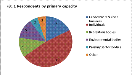
be published on the Council’s website.
5. Forty written responses
were received from a range of respondents (Figure 1).
6. The range and frequency
of issues raised is indicated in Figure 2 below.
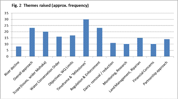
7. An overview of comments
received on each of these issues is provided below.
7.1. River decline. River users with first-hand experience of the water quality
decline express frustration that anecdotal evidence appears to have been given
little weight in Council’s decision-making to date.
7.2. Overall approach. Concerns are raised that the proposed “balanced approach” for
healthy rivers and future viability of Taharua farms could compromise
the primary objective of restoring and maintaining the integrity of the
outstanding upper Mohaka river system for environmental, social, cultural and
wider economic benefits. Council’s approach to limits and timeframes should
embody the “precautionary principle”, given the value of rivers and scientific
uncertainty.
7.3. Scope of
provisions. The Strategy should take a more
holistic approach to:
7.3.1. Issues. Fish and Game, the Wellington Hawke’s Bay Conservation Board (DOC Board) and others consider the Draft Strategy overly focuses on nitrogen (the existing
contaminant of concern) instead of the range of factors that can impact river
and riparian ecosystem health and biodiversity. This relates particularly to
management objectives and water quality limits.
7.3.2. Geographical
extent. There is concern the Draft Strategy does
not adequately address land use and intensification risks in the neighbouring
Ripia and Waipunga sub-catchments and therefore cannot protect the outstanding
characteristics and features of the Water Conservation Order (WCO).
7.4. Water Conservation
Order. The ambiguity of the WCO raises concern that
Council is failing its statutory obligations (legal advice has clarified these
complex legal obligations). Regardless of legal intricacies, the public clearly
attach very high value to protection of the outstanding Mohaka River system and
view the WCO as a clear expression of its value.
7.5. Management
Objectives and Water Quality Limits. An ecosystem
health and biodiversity approach should be made explicit in clearer, more
certain objectives. Proposed limits receive less public attention than
timeframes, but this may reflect their technicality. The proposed limits are
critiqued by a Fish and Game commissioned report, which questions their current
“fitness for purpose”.
7.6. Timeframe and progress
“milestones”. The 10 year timeframe for landowner
action to meet 15 year water quality targets is widely opposed as too long
(note: economic assessment of the likely difficulty of meeting targets was not
available to inform discussion). More frequent landowner progress “milestones”
should be considered to prevent slippage.
7.7. Regulation and
enforcement. Use of regulation to manage Taharua
and other sensitive catchments is strongly supported. Opinion is divided on the
form this should take. Many support a strong and prescriptive regulatory
approach, focussed inputs (e.g. cow numbers, fertiliser), but others advocate a
more flexible, “outputs” approach. Regulation must be backed by effective
compliance monitoring and enforcement, which is considered too weak to date.
7.8. Dairy restriction
or removal. Many respondents consider dairy an
inappropriate Taharua land use due to the catchment’s physical characteristics.
Suggested responses range from limiting future dairying to complete removal
over time.
7.9. Monitoring and
research. Effective monitoring programmes must be
developed upfront to inform progress and timely review (ecosystem health/water
quality, farm systems adaptation, dairy compliance, plan effectiveness).
7.10. Land and riparian
management. Land management should address a range
of catchment issues, not just nitrogen. This should include phosphorus
management, soil health and retention, biodiversity and riparian/wetland
enhancement.
7.11. Financial concerns. Many support a strong “polluter pays” approach, with the onus on
dairy farms to pay for river clean-up. Others suggest financial assistance may
be appropriate and necessary, given the potential scale of the task and
Council’s role in the catchment’s development history.
7.12. Partnership
approach. Council’s partnership with the TSG is widely, if not unanimously, supported providing there is sufficient evidence of progress
in restoring river health and adequate opportunity for public and other
stakeholder input.
8. In summary, the public
consultation highlights important issues for the Council to consider in
finalising its Taharua and Upper Mohaka Strategy and developing the statutory
plan change. Three key questions are discussed below:
8.1. Should plan change
provisions be extended to the Ripia and Waipunga catchments?
Extension of plan
change provisions to the neighbouring Ripia catchment has merit. The
outstanding trout fishery cannot be adequately restored and maintained without
this. Developing a Ripia framework may not be too complicated as: proposed
limits would be met (current water quality is good); key landowners (not all)
are on the TSG; and possible regulation of land use change/intensification
could be limited to permitted activity, subject to conditions, or controlled
activity status.
Addressing the
Waipunga catchment, which impacts mid-Mohaka water quality[1], is problematic.
Issues and values in the middle reach are currently not well understood and
differ from the upper Mohaka. Sediment/clarity issues are likely linked with natural
vegetation and forestry. An increasing nitrogen trend may be linked with dairy
in Bay of Plenty region. A full “Taharua-style” stakeholder process may be
required to establish water quality targets and an inter-regional management
framework.
8.2. What is an
effective suite of management objectives and water quality limits?
Improved objectives
will be developed with key stakeholders (e.g. Fish and Game, DOC) and the TSG that reflect Council’s intended “ecosystem approach.” Suites of water quality limits
will be investigated, with appropriate independent review (note: establishing
phosphorus limits may be problematic). Staff agree that nitrogen management
alone (albeit the key elevated nutrient) will not ensure future health of the
rivers. There is merit in developing a strategy and plan change which ensures
effective phosphorus, soil, riparian and wetland management.
8.3. What is an
appropriate timeframe for action?
Any decision on the
timeframe needs to be informed by assessment of on-farm costs of meeting
targets and wider cost-benefits. On-farm assessment to date indicates a shorter
timeframe may be achievable, but considerable uncertainties have arisen (15.1
below). A shorter timeframe may require
financial assistance or see a shift back to a typical adversarial plan change
process with parties being more entrenched in their respective interests and
positions. Furthermore, eroding existing use rights could be deemed
unreasonable under s.85 of the Resource Management Act (RMA).
9. Staff will need to
systematically work through these complex issues with key parties and the TSG and report back to Council. This essential work has implications for the plan change
timeframe, particularly if the scope of the plan change is to be significantly
extended.
Review Of Policy
Development Process To Date
10. In light of issues
raised by the public and with plan change notification targeted for end 2011,
staff commissioned Rob van Voorthuysen to undertake a preliminary review of
Council’s progress toward systematic policy development. Rob van Voorthuysen
is very experienced in this area of land use planning having acted as Hearings
Commissioner for the Horizons’ One Plan and provided expert planning evidence
on Environment Waikato’s Variation 5 (Lake Taupo). He is currently providing
similar advice to ECan’s Commissioners on managing diffuse nutrient
discharges. Rob van Voorthuysen’s report is included as Attachment 1.
11. Issues highlighted by
the public consultation are confirmed by the van Voorthuysen review. The review
also confirms that Council still needs to undertake a significant body of work
if a systematic policy development process is to be followed. This is
particularly the case for policy development Step 3: identifying the full range
of potential solutions; codifying the preferred solution within a draft plan
change; and justifying it in an accompanying RMA s.32 report.
12. Progress with some
critical “Step 3” work streams identified by the review are examined below.
13. Determining the
required reduction in catchment nitrogen load. NIWA’s
Mohaka nitrogen model is critical, but substantial delivery delays and checking
of model inputs, assumptions and limitations have delayed policy discussions.
This time-consuming model building work has been necessary as model outputs
will inform the plan change and must withstand scrutiny in the Environment
Court. Staff are now confident that the model provides a satisfactory starting
point (to be refined over time) and the final report is available. The van
Voorthuysen report’s recommended steps in section 5(f) can now be carried out
as priority work to inform TSG discussion. If required, the model can inform
policy development in other upper Mohaka sub-catchments.
14. Allocation of
nitrogen discharge allowances. This is an essential
component of the plan change, but discussions with landowners have been delayed
by the NIWA model (above). Meaningful discussion also requires
understanding of the financial implications of the task for individual
landowners. This major area of uncertainty is discussed below, but could hold
up policy development for considerable time.
15. Economic analysis of
benefits and costs of restoring river health. The
van Voorthuysen report confirms that this work is essential to justify a
preferred plan change approach. Inadequate analysis risks Environment Court
challenge and potential plan modification, deletion or replacement,
particularly if any controls render existing uses of land incapable of
reasonable use (RMA s85). Staff are progressing the two components required for
robust economic analysis:
15.1. Understanding
on-farm costs. Staff are working with consultants,
landowners and DairyNZ to evaluate options to reduce nitrogen leaching on two
of the three dairy farms (meaningful assessment of the farm in receivership is
not possible). The consultants are examining additional options and a report is
likely in November. Reducing nitrogen leaching could theoretically take two
paths, but each appear to have some obstacles:
· Approach
1: Reduce intensity of farm system: modelling
indicates that by reducing stocking rates, fertiliser inputs and production,
farmers may be able to significantly reduce nitrogen leaching while maintaining
profitability. However, key uncertainties need addressing: the viability of
pasture under low/zero fertiliser regimes (the physical characteristics of the
catchment may result in system crash); confidence in Overseer leaching
estimates; and lending institutions’ acceptance of this approach (see below).
· Approach
2: Investing in farm infrastructure: use of
stand-off pads and herd homes to reduce leaching is being modelled. Investment
of this magnitude would mean productivity and profitability would need to
increase, therefore more stock. Again, initial discussions suggest banks may
not support such additional investment under their current lending regimes.
15.1.2. Bank
lending policy. Two rural banking managers (one
involved with the farms) have indicated bank lending policies may restrict
farmers from reducing nitrogen losses by either of the above approaches. This
has potentially far reaching implications. It is intended that the Chief
Executive will initiate high-level dialogue with the banks. Local bank
representatives will also need to be invited to be part of Taharua farm system
discussions.
15.1.3. Viability
of alternative land uses. Consultants have been
engaged to examine forestry as an alternative land use within the Taharua
catchment. This will inform future catchment management options. The relative
merits of forestry and extensive pasture (beef/deer) needs to be investigated
as Westervelt (Poronui), are seeking flexibility to replace existing, unviable
eucalypt forest. This complicates landowner negotiations and could
substantially increase the reduction task for dairy farmers. If alternative
forestry is attractive, this may assist negotiations.
15.1.4. Clean-up
Fund. It is possible that landowners could be
assisted in making necessary changes by the Government’s recently announced
‘Fresh Start for Fresh Water Clean-up Fund.’ Staff will apply to the Ministry
for the Environment by the 31 October deadline for a share of the currently
unallocated national “pot” of $9 million over 2 years. MfE officials advise
that successful regional councils will be notified late January/early February
2012.
15.2. Understanding wider
benefits/costs. If improving water quality results
in a significant cost for the landowners, then Council needs to understand the
cost-benefit relationship on a wider catchment and regional level. That is,
what are the benefits (tangible and intangible) to other landowners, businesses
and the community, and do they outweigh the costs? This is important
Environment Court evidence, but is a complex and potentially costly task. Initial
discussion with specialised resource economists suggests between 3-6 months and
$30-60k+, may be required, although a “bare minimum” approach may be possible.
16. Development of plan
objectives, policies, rules and other methods. The
van Voorthuysen report advises that for a systematic policy development
process, Council must address issues highlighted in Step 1 (management
objectives) and Step 2 (problem definition) before Step 3 (policy selection)
and this needs to be further progressed before staff can meaningfully start
developing the policy framework.
17. In the meantime staff
have been examining plan change options, the format it might take within the
RRMP, including possible wording of objectives and policies consistent with the
Draft Strategy.
Taking Stock And Way
Forward
18. Until recently, staff
had an optimistic view that with the benefits of a relatively small catchment
area and a small number of stakeholders, collaboration would see progress made
quicker than a traditional, typically adversarial approach to changing regional
plans. But the van Voorthuysen report clearly confirms the complexities of
dealing with catchment-based responses to diffuse nutrient leaching and
resultant water quality problems.
19. Despite Taharua’s size,
technical complexities are similar to those encountered with the Taupo, Rotorua
Lakes and Horizons-Manawatu (OnePlan) regimes. In important respects, the
challenge is even greater and precedent setting insofar as:
19.1. it could be the first
regulatory regime in the country requiring existing farmers to reduce nutrient
loadings to meet water quality targets (ie: not just a ‘cap’ on nutrients);
19.2. there is currently no
multi-million dollar government-approved fund allocated to facilitating
nutrient reductions (unlike that available for Lake Taupo and Rotorua lakes);
and
19.3. Council is looking for
upfront agreement to such a framework, through the TSG partnership, to minimise
potentially substantial Environment Court delays and enable real ongoing
catchment improvements.
20. The van Voorthuysen
report comments that a more feasible timeframe for notification of a plan
change than the current deadline of end-2011 could be mid-2012, if sufficient
Council resources are available to undertake the remaining work identified in
that report. However, given the complexity of the issues and possible policy
responses, together with Council’s commitment to a collaborative process with
the TSG, staff are reluctant to commit to a new date without a comprehensive
review.
21. Staff consider there to
be no obvious ‘shortcuts’ to the policy development process. Basically, all
work underway is critical to informing finalising the Strategy and preparing a
plan change for the Taharua and upper Mohaka Rivers.
22. Given the complexity of
the resource management issue to be resolved and the significant implications
of the options available, staff propose seeking more comprehensive advice on
policy development steps, assessment of resource requirements (both within
existing budgets and if any new resources would be necessary), assessment of
realistic timeframes for notification and legal advice on implications of RMA
s.85 (compensation). The advice would build upon the preliminary van
Voorthuysen report, together with this report, particularly in terms of
assessing resource requirements and resultant timeframes.
23. Staff also propose
regular progress reporting during the remaining phases of finalising the
‘Taharua and Upper Mohaka Strategy’ and preparation of a change to the Regional
Resource Management Plan for this catchment. Staff propose presenting progress
report summaries to future meetings of the Environmental Management Committee
(and then the Regional Planning Committee once operational). On this basis,
the next progress summary is proposed to be presented to the Committee’s
meeting in February 2012.
Decision
Making Process
24. Council is required to
make a decision in accordance with the requirements of the Local Government Act
2002 (the Act). Staff have assessed the requirements contained in Part 6 Sub
Part 1 of the Act in relation to this item and have concluded the following:
24.1 The decision does not
significantly alter the service provision or affect a strategic asset.
24.2 Consultation
requirements are set out in the Resource Management Act and are being followed
for the process.
24.3 The decision does not
fall within the definition of Council’s policy on significance.
24.4 The persons affected by
this decision are the Hawke's Bay regional community.
24.5 Options that have been considered
in relation to the public comment on Taharua and Upper Mohaka Strategy relate
to: (a) refining management objectives and water quality limits; (b) extension
of geographical scope to Ripia and Waipunga sub-catchments; and (c) the
timeframe for action to meet water quality limits and progress milestones.
24.6 Options that have been
considered in relation to the Taharua plan change relate to: (a) timing of
notification by the end of 2011; and deferral of notification pending fuller
assessment of issue complexities, resourcing requirements; realistic timeframes
for notification and availability of crucial information to inform
collaborative policy development with the TSG.
24.7 The decision is not
inconsistent with an existing policy or plan.
24.8 Given the nature and
significance of the issue to be considered and decided, and also the persons
likely to be affected by, or have an interest in the decisions made, Council
can exercise its discretion and make a decision without consulting directly
with the community or others having an interest in the decision.
|
RECOMMENDATIONS
The
Environmental Management Committee recommends that Council:
1. Agrees
that the decisions to be made are not significant under the criteria
contained in Council’s adopted policy on significance and that Council can
exercise its discretion under Sections 79(1)(a) and 82(3) of the Local
Government Act 2002 and make decisions on this issue without conferring
directly with the community and persons likely to be affected by or to have an
interest in the decision due to the nature and
significance of the issue to be considered and decided.
2. Notes
public feedback received on the ‘Taharua and Upper Mohaka Draft Strategy’.
3. Receives
the van Voorthuysen report (Attachment 1) and notes its conclusion that
notification of a Taharua-upper Mohaka plan change by end 2011 is
unrealistic.
4. Notes the
complexity of the planning environment with respect to managing land uses for
water quality enhancement purposes.
5. Agrees that
staff continue to compile the information required in order to prepare a
robust statutory plan change and associated section 32 evaluation.
6. Agrees
that for future Environmental Management Committee meetings, staff present
updates outlining progress on significant work streams and that at the
February 2012 meeting a comprehensive programme for completion of a robust
statutory plan change is prepared for the Committee’s consideration.
|
|

Chris Reed
Senior
Planner
|

Brendan Powell
Land
Management Officer Intensive Land Use
|
|
Helen Codlin
Group
Manager
Strategic
Development
|

Mike Adye
Group
Manager
Asset
Management
|
Attachment/s
|
1View
|
Taharua Upper
Mohaka Policy Development Process
|
|
|
|
Taharua upper Mohaka policy
Development Process
|
Attachment 1
|


HAWKE’S BAY REGIONAL COUNCIL
Environmental
Management Committee
Wednesday 12 October 2011
SUBJECT: Regional Policy Statement "Built
Environment" Plan Change Update
Reason For Report
1. This report provides an
update on preparation of the ‘Built Environment’ Change to the Regional Policy
Statement (RPS). Staff had previously indicated that a final draft plan change
could be presented to this Committee meeting, but staff now consider it
premature to do so until additional work is undertaken.
Update
2. This report follows on
from a report presented to the Environmental Management Committee in August
2011. The Committee had endorsed a draft proposal changing the RPS to address
management of the built environment.
3. Since the August
meeting, several actions have occurred, most notably:
3.1. Staff revised the Draft
Change to accommodate matters arising at the Committee meeting;
3.2. Draft Change was
circulated to a range of key stakeholders inviting their feedback (originally
by 30 September which was a tight timeframe), now extended to 20 October;
3.3. Draft Change and
explanatory material posted on Council website;
3.4. Advisory notice given to
submitters on HPUDS referring to material on website;
3.5. Draft Change presented
to HPUDS Implementation Committee meeting on 13 September;
3.6. Drafting underway to prepare
a s32 Evaluation summary report on the RPS Change; and
3.7. Legal review of Draft
Change commissioned and underway.
4. An initial deadline of
30 September for stakeholder and public feedback was tight and has since been
extended to 20 October. This consequently meant feedback would not ‘fit’
timing to finalise a Draft Change and present a ‘Final Draft Change’ to the
Committee’s 12 October 2011 meeting. However follow-up actions as a result of
the HPUDS Implementation Committee also meant a need to extend the timeframes
for notification.
Hastings District Council’s intensification assessment
5. Hastings District
Council expect that its urban intensification assessment[2] will be completed
shortly. This will complement the assessment and identification of future
greenfield growth areas nominated in HPUDS and embedded in the Draft RPS
Change.
HPUDS Implementation Committee (IC)
6. The Draft RPS Change
was presented to the HPUDS IC on 13 September. The matter urban limits being
defined in the RPS was discussed at length. The HPUDS IC requested that the
HPUDS TAG[3] (technical advisory group) to look at how urban limits could be
mapped/represented in a way that provided clear direction in the face of
private plan change requests and resource consent applications etc, while also
providing flexibility in relation to district plan changes. Regional Council
staff have requested specific legal advice on the implications associated with
mapping and/or defining urban limits in the RPS. Advice has also been sought now
on any legal implications for territorial authorities and district plans if the
RPS were to map greenfield growth areas using one of several styles (ie: with
same approximation as mapped in HPUDS; with indicative location ‘X’ markers
only; or a hybrid style).
7. Given the importance of
getting this right in the RPS, the HPUDS TAG have taken a ‘make haste slowly’
approach. Regional Council staff support this approach and now propose to
bring the plan change back to the Council for consideration and adoption in
November.
Steps to Notification
8. The steps to be taken
before content of a draft RPS Change can be finalised and adopted include:
8.1. incorporation of
comments and recommendations arising from the legal review by Simpson Grierson;
8.2. incorporation of
feedback from key stakeholders and wider public;
8.3. clarification of how the
RPS Change can define future greenfield growth areas and urban limits for the
Heretaunga Plains sub-region;
8.4. completion of project by
Hastings District Council on intensification to complement RPS Change’s
provisions that relate to urban intensification, greenfield growth in limited
circumstances, limited rural lifestyle developments, and provision of
appropriate infrastructural services; and
8.5. finalising s32 evaluation
summary report, particularly accommodating any revisions arising from feedback
and legal review.
9. Staff anticipate that a
final draft change and supporting section 32 report for the Committee’s
consideration (incorporating public feedback and legal reviews) will be
finalised in time to present to the last scheduled committee meeting day of
2011 – the Asset Management and Biosecurity Committee meeting on 16 November.
This timing would mean the Council could choose to adopt the Change and notify
it prior to Christmas.
Decision Making Process
10. Council is required to
make a decision in accordance with the requirements of the Local Government Act
2002 (the Act). Staff have assessed the requirements contained in Part 6 Sub
Part 1 of the Act in relation to this item and have concluded the following:
10.1. The decision does not
significantly alter the service provision or affect a strategic asset.
10.2. Consultation
requirements for plan changes are set out in the Resource Management Act and
those are being followed for this Draft RPS Change.
10.3. The decision does not
fall within the definition of Council’s policy on significance.
10.4. The persons affected by
this decision are the Hawke's Bay regional community.
10.5. Options that have been
considered include to postpone consideration of documents to Change the RPS for
managing the built environment; or to adopt the documents in their current
state before feedback and legal reviews are complete.
10.6. The decision is not
inconsistent with an existing policy or plan.
10.7. Given the nature and
significance of the issue to be considered and decided, and also the persons
likely to be affected by, or have an interest in the decisions made, Council
can exercise its discretion and make a decision without consulting directly
with the community or others having an interest in the decision.
|
Recommendations
The
Environmental Management Committee recommends that Council:
1. Agrees that the decisions to be made
are not significant under the criteria contained in Council’s adopted policy
on significance and that Council can exercise its discretion under Sections
79(1)(a) and 82(3) of the Local Government Act 2002 and make decisions on
this issue without conferring directly with the community and persons likely
to be affected by or to have an interest in the decision due to the nature and significance of the issue to be considered
and decided.
2. Agrees to defer the adoption of a ‘Built Environment’ Change
to the RPS until a meeting of the Environmental Management Committee to be
scheduled following the Asset Management and Biosecurity Committee meeting on
16 November 2011.
|
|

Gavin Ide
Team Leader Policy
|
Helen Codlin
Group
Manager
Strategic
Development
|
Attachment/s
There are no
attachments for this report.
HAWKE’S BAY REGIONAL COUNCIL
Environmental
Management Committee
Wednesday 12 October 2011
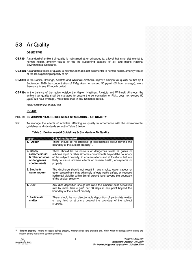
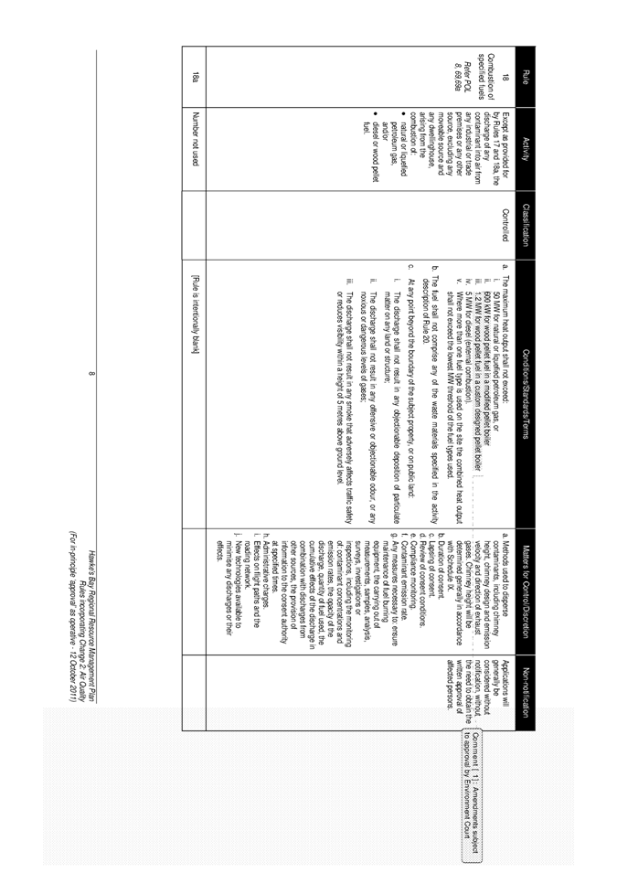
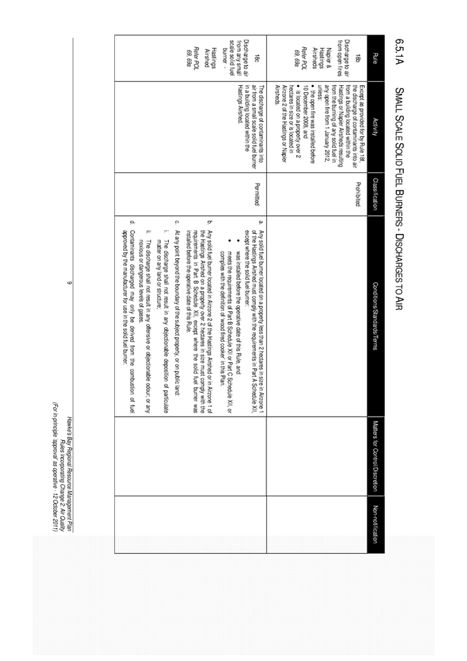
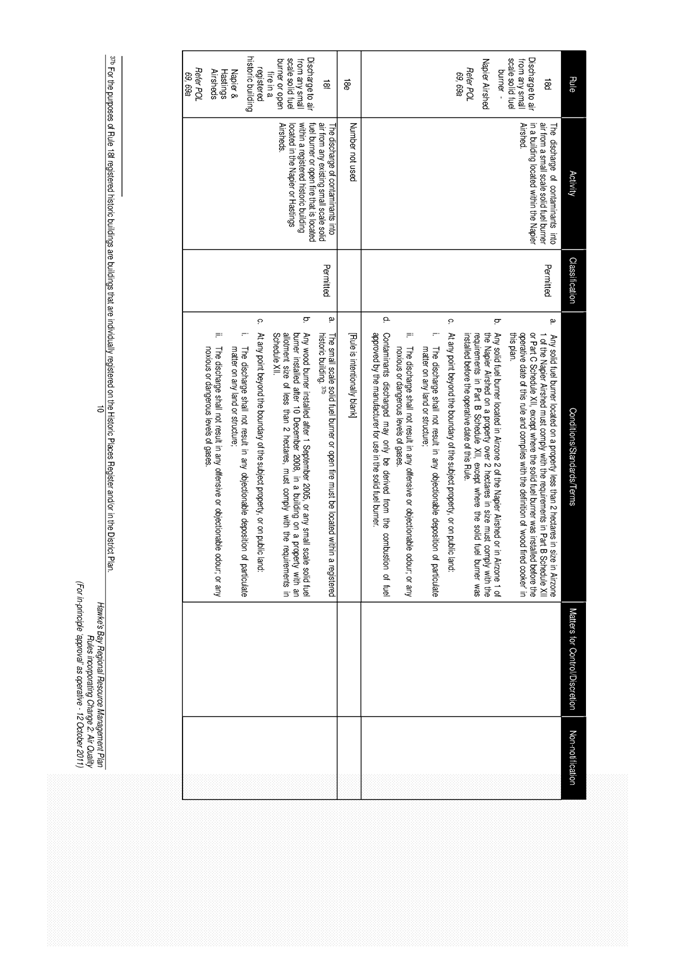
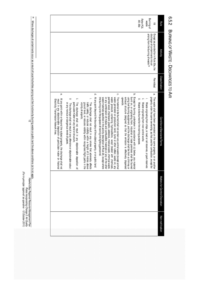
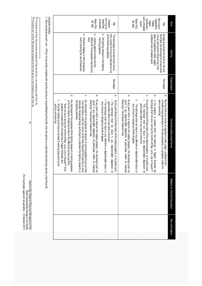
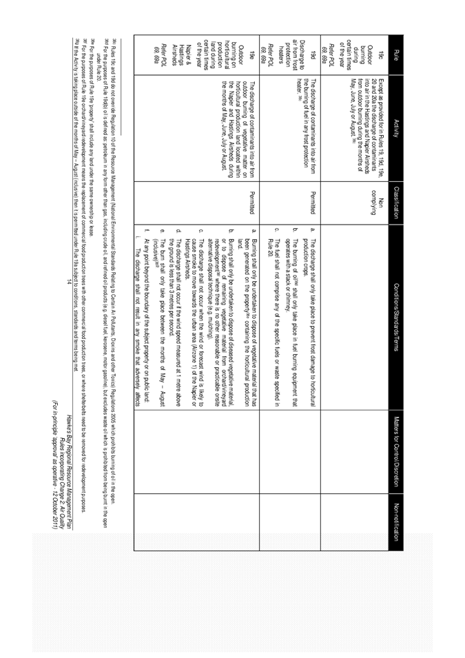
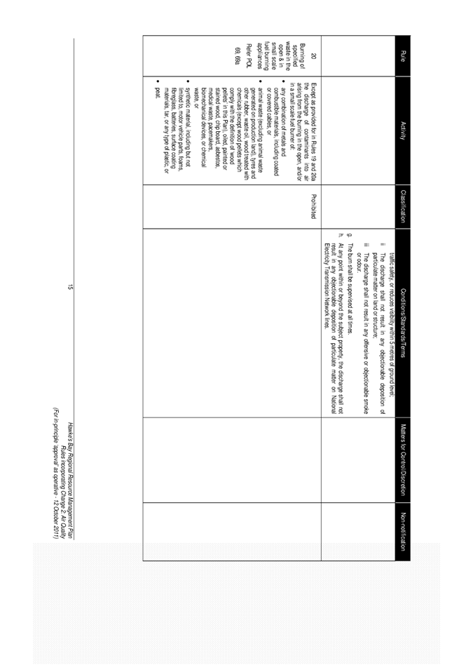
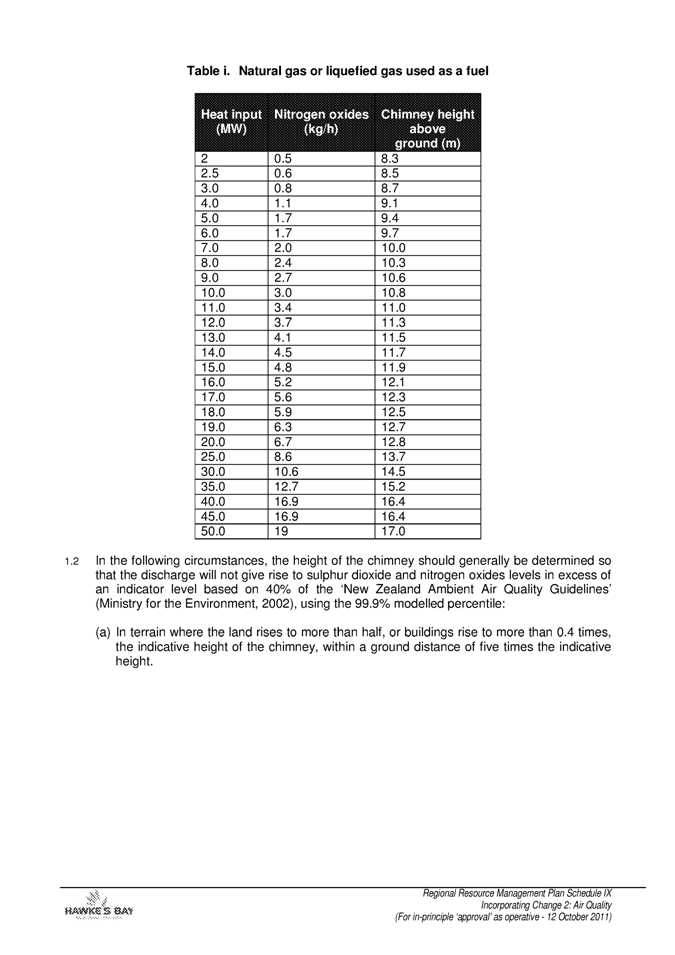
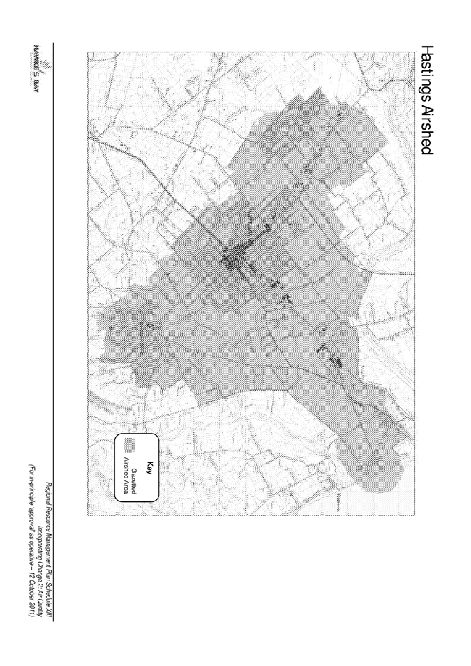
SUBJECT: Air Quality Plan Change
Reason For Report
1. Appeals against
Council’s decisions on Change 2 to the Regional Resource Management Plan have
virtually all been settled without the need for an Environment Court hearing.
This report seeks Council’s in-principle agreement that Change 2 should be
declared operative from 1 January 2012, providing appeals are settled within
the next few weeks.
2. Once operative, Change
2 will give impetus to Council’s efforts to improve air quality in the Napier
and Hastings Airsheds. Results of monitoring PM10 concentrations
during the past winter show some positive aspects compared to previous years
but a downward trend in concentrations needs to be firmly established to meet
the National Environmental Standards (NES) in 2016 in Napier and 2020 in
Hastings.
Background
3. Change 2 and Variation
2 were proposed so that measures could be introduced to help residents of
Hawke’s Bay enjoy good air quality throughout the year. Monitoring shows that
on occasions during winter air quality in the Napier and Hastings Airsheds
reach levels that breach the NES and the primary cause is the burning of wood
for domestic heating.
4. Three appeals were
lodged against Council’s decisions on Change 2 and Variation 2. The appeal by
Horticulture NZ was settled earlier this year. Napier City Council withdrew
its appeal in August 2011 resulting in no amendments to Change 2 or Variation
2.
5. At the time of writing,
an agreement signed by Solid Energy NZ Limited and all relevant parties was
about to be presented to the Court. The Environment Court will process that
agreement before issuing its approval (known as a ‘Consent Order’) to settle
the appeal by Solid Energy NZ Limited.
6. Appeals on Variation 2
to the proposed Regional Coastal Environment Plan have also been similarly
settled. However, the same steps do not apply to Variation 2 because Variation
2 amends a proposed plan that itself is not yet operative.
7. Assuming the Court does
approve the signed Solid Energy appeal agreement, all matters in appeals will
be settled in a matter of weeks. This means all provisions in Change 2 will be
'beyond challenge' and then deemed operative. The last remaining procedural
step requires Council to “approve” Change 2 and declare the Change “operative”
from a specific date.
8. A copy of Change 2 is
attached. The attachment highlights the last few provisions pending settlement
of the appeal by Solid Energy NZ Limited.
Making The Plan
Operative
9. A Council resolution is
required to make Change 2 operative. For Change 2 to become operative, the
Council must first formally ‘approve’ the change and then decide on a date from
when the Change is operative. The Council must then give public notice of the
date from which Change 2 will become operative.
10. This decision is merely
a procedural step. It is not an opportunity to re debate the content of Change
2. If Council is inclined to now modify some or all of the content of Change
2, then that must follow due process as a separate plan change – not an add on
at this step in the process.
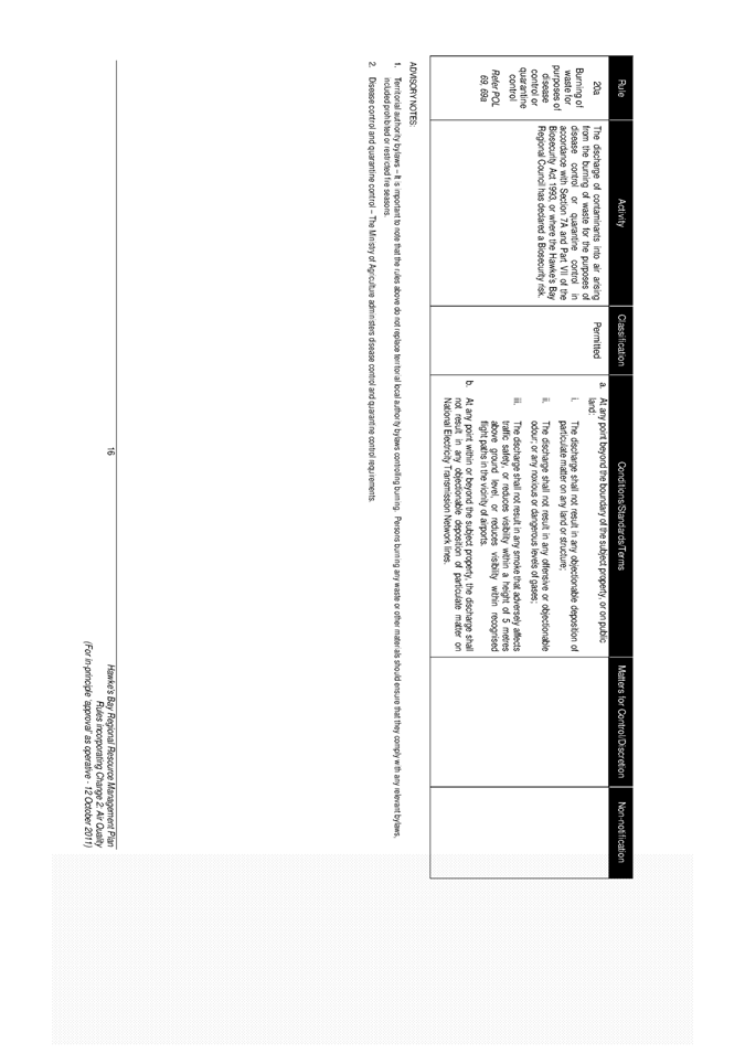
Rule 18h - Time Of
Sale Rule
11. Some parts of Change 2
are already ‘beyond challenge’ such as Rule 18h (commonly referred to as the
‘time of sale rule’). However, the wording of Rule 18h means that it will not
come into force until the Council declares Change 2 operative and specifies a
date from which provisions in Change 2 become operative.
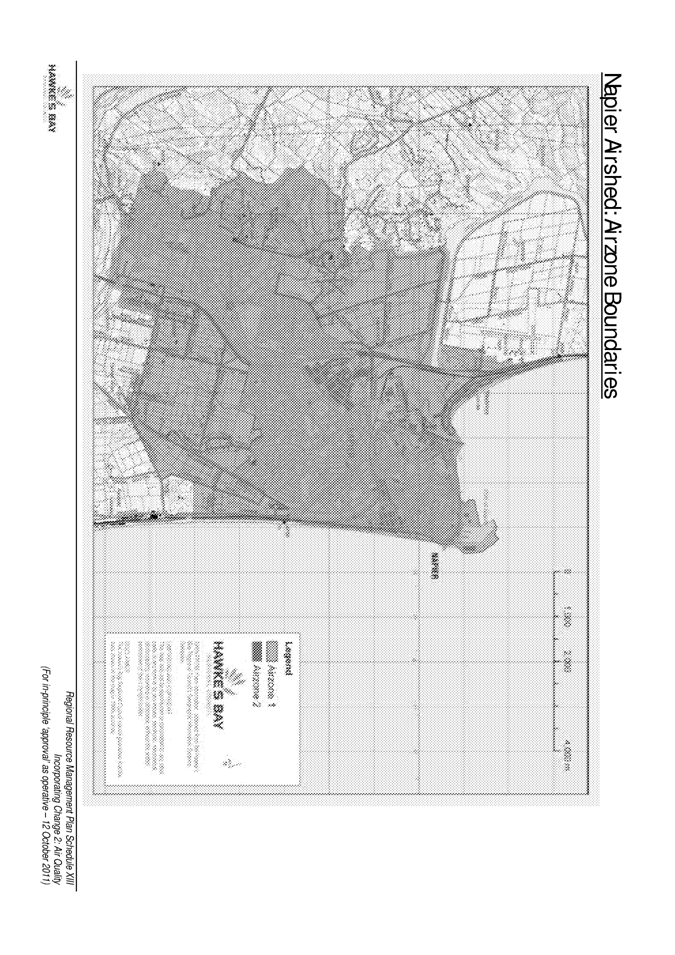
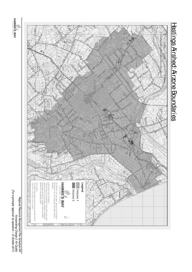
12. Rule 18h applies to
properties only within the Napier Airshed or Hastings Airshed. Rule 18h
prohibits the use of any non-compliant burner on a property after that property
has been transferred (sold), effectively meaning new occupants can only use
alternative cleaner home heating options.
13. Rule 18h comes into
force after the rule is made operative. In order for this to happen, the
Council needs to resolve that Change 2 is to be made ‘operative’ and must give
notice of a date when the Change becomes operative.
Setting An Operative
Date
14. Staff recommend that
Council agree in-principle that the operative date for Change 2 (so Rule
18h consequently comes into force) be set at 1 January 2012, given uncertainty
over exactly how long it may take the Court to approve the signed Solid Energy
appeal agreement. Agreeing an in-principle date will provide a lead in time of
nearly three months (October – December) before Rule 18h potentially comes into
force.
15. Setting the operative
date at 1 January 2012 will mean that Rule 18h, the open fire phase-out date;
and the operative date for Change 2 will all occur on the same day.
16. Staff propose that this
in-principle date of 1 January 2012 will be confirmed at a scheduled Council
meeting in November or December once the Court approves the Solid Energy appeal
agreement. Equally, the date can be revisited in the unlikely event that the
Court does not accept the signed agreement.
17. A communications
strategy has recently been prepared for the purposes of communicating the
implications and timing of Rule 18h ahead of the prohibition coming into force.
The communications strategy features details of Rule 18h being sent out with
rates notices (but not any details of precisely when the rule comes into
force); a story published in the Council’s newsletter; and a media release
informing media readers/listeners of the burner phase-out rules no longer being
subject to appeals. The communications strategy also identifies staff having
targeted discussions with branch representatives of real estate agents, Hawke's
Bay valuers and conveyancing lawyers after Council adopts in-principle a
specific operative date.
Trends In Pm10 Concentrations
18. The Council has two
sites that are dedicated to permanent and continuous monitoring of PM10
concentrations, one at St John’s College in the Hastings Airshed and the other
at Marewa Park in the Napier Airshed. Both have been operating since 2006 and
both have recorded 24 hour averaged PM10 concentrations in excess of
the NES (50µgm-3) every year during winter months. Repeated failure
to meet the NES reinforces the need for Change 2 (and Variation 2) to work
alongside the financial assistance offered by Council for conversions to clean
heating.
19. Figure 1 shows the
number of times the NES has been exceeded in Hastings each winter since 2006.
In 2011 there were 12 such occasions. This equals the previous lowest total
recorded in 2009 despite there being a greater prevalence of cool, calm
conditions (or ‘characteristic days’) which are conducive to high PM10
concentrations. The maximum and average concentrations across the winter were
below those recorded in the previous five years.
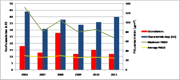
Figure 1: Hastings Airshed PM10 trends
20. In Figure 2, PM10
concentrations in Napier exceeded the NES on four occasions this year (see
graph below), which is one more than occurred in the previous two years however
cool, calm days were more common. The maximum concentration was the second
lowest since 2006 and the winter average concentration fell below all other
years.
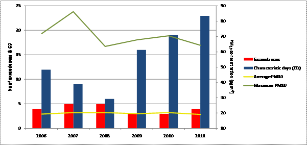
Figure 2: Napier Airshed PM10 trends
21. Normalised PM10
concentrations, adjusted to account for varying meteorological conditions, are
trending downward in Hastings while Napier’s results this year were very
similar to last year.
22. PM10
monitoring this year shows some encouraging signs that Council’s initiatives to
date to improve air quality may be having some effect, particularly in
Hastings, but significant decreases in ambient concentrations of PM10
are needed to meet the NES. Any downward trend in concentrations should gain
more traction once rules in Change 2 become operative.
Summary
23. Agreement in-principle
is sought to adopt Change 2 and the date at which the Change will become
operative so that an appropriate lead-in time can be given to residents and
property advisors regarding the ‘time of sale’ rule (Rule 18h). Once the last
appeal has been settled, the Change and the operative date will be submitted
directly to a Council meeting for adoption.
Decision Making
Process
24. Council is required to
make a decision in accordance with the requirements of the Local Government Act
2002 (the Act). Staff have assessed the requirements contained in Part 6 Sub
Part 1 of the Act in relation to this item and have concluded the following:
24.1. The decision does
not significantly alter the service provision or affect a strategic asset.
24.2. Consultation
requirements for plan changes are set out in the Resource Management Act and
have been followed for Change 2.
24.3. The decision does
not fall within the definition of Council’s policy on significance.
24.4. The persons
affected by this decision are the Hawke's Bay regional community.
24.5. Options that have
been considered include to approve Change 2; not approve Change 2; and to
approve in-principle pending confirmation of signed appeal agreements from the
Environment Court; and selection of various possible operative dates.
24.6. The decision is not
inconsistent with an existing policy or plan.
24.7. Given the nature
and significance of the issue to be considered and decided, and also the
persons likely to be affected by, or have an interest in the decisions made,
Council can exercise its discretion and make a decision without consulting
directly with the community or others having an interest in the decision.
|
Recommendations
The
Environmental Management Committee recommends that Council:
1. Agrees that the decisions to be made are not significant under the
criteria contained in Council’s adopted policy on significance and that
Council can exercise its discretion under Sections 79(1)(a) and 82(3) of the
Local Government Act 2002 and make decisions on this issue without conferring
directly with the community and persons likely to be affected by or to have
an interest in the decision due to the nature and
significance of the issue to be considered and decided.
2. Subject to
the Environment Court issuing a Consent Order settling the appeal by Solid
Energy NZ Limited:
2.1. Agree
in-principle to approve Change 2 (Air Quality) to the Regional Resource
Management Plan in accordance with Clause 17 Schedule 1 of RMA; and
2.2. Agree
in-principle that Change 2 become operative from 1 January 2012.
3. Receives
the information about PM10 concentration trends within the Napier
and Hastings Airsheds.
|
|

Belinda Riley
Senior
Planner
|

Kathleen Kozyniak
Senior
Scientist Climate & Air
|
|
Graham Sevicke-Jones
ACTING
GROUP MANAGER
RESOURCE
MANAGEMENT
|
Helen Codlin
Group
Manager
Strategic
Development
|
Attachment/s
|
1View
|
Change 2 for
In-Principle Approval as Operative
|
|
|
|
Change 2 for in-principle approval as
operative
|
Attachment 1
|


HAWKE’S BAY REGIONAL COUNCIL
Environmental
Management Committee
Wednesday 12 October 2011
SUBJECT: Plan Change Process for Heretaunga
Zone - Integrated Catchment Management
Reason For Report
1. The purpose of this
report is to bring to the Committee’s early attention the proposal to address
the scheduled review of the minimum flow and allocation limits of the Karamu
Stream as part of an integrated catchment approach for the wider Heretaunga
Zone.
2. This report gives an
overview of the issues only. As part of an integrated catchment management
approach, a more detailed project programme needs to be developed.
3. This report also
provides useful background to the Council’s Long Term Plan workshop on Thursday
13th October 2011.
The Heretaunga Zone
4. Figure 1 defines the
Heretaunga Zone used for the section 36 charges and it generally includes the
catchment and areas that, from a surface water and groundwater management
perspective, need to be managed in a holistic and integrated way.
5. It includes the
Heretaunga Plains aquifer system which extends from the southern edges of
Napier to Te Awanga and inland to the hills. This is a large highly productive
complex aquifer system with confined, unconfined and artesian
conditions.
6. The map includes the
Ahuriri Estuary and Poraiti Hills aquifer and further analysis is required to
determine whether that area should be included from an integrated water management
perspective.
7. There are a number of
rivers that flow over the plains and may loose water to the aquifer system or
may gain water from the aquifer via springs. Some of these rivers have their
headwaters in the ranges (Tutaekuri and Ngaruroro), some from the surrounding
lowland hills (Tutaekuri-Waimate and the Karamu/Clive).
8. The name Heretaunga
also reflects the association that tangata whenua with the name of Heretaunga
when it referred to a much larger area than it does now
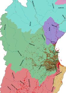 Figure
1: Heretaunga Zone in green
Figure
1: Heretaunga Zone in green
Resource Consents and Expiry Dates
9. There are a total of
3679 current consents in the Heretaunga zone representing approximately half of
the region consented activity. Of these, 2561 (approx. 70%) relate to taking,
use damming and diverting of surface water and groundwater.
10. Of the 2561, the bulk of
the Ngaruroro River and Maraekakaho takes expire in 2015 along with the Twyford
groundwater takes that are considered to be stream depleters, with the vast
majority of the groundwater takes from the unconfined part of the Heretaunga
Plains expiring in 2019. The majority of the surface and groundwater takes in
the Tutaekuri River catchment expire in 2018.
11. Only some 30 consents
expire in 2013. These are in the Karamu river catchment (excluding the Poukawa
catchment) and have been the driver for the scheduled Karamu Plan change.
These consents were granted with a five year term to allow for further
scientific investigations to be undertaken in regard to reviewing the minimum
flow and allocatable volumes.
12. Since then, the Twyford
consent renewal process has further highlighted the interconnectedness of the
surface water and groundwater systems. How this interconnectedness is managed
across the Heretaunga Plains aquifer system and the surface waterbodies that
are linked with it (ie the Upper Karamu (Paritua, Karewarewa, Irongate),
Ngaruroro, Tutaekuri-Waimate and Tutaekuri Rivers) will be a key element to
address and requires an integrated approach.
Water Use Information
13. The Twyford consent
process also highlighted the lack of real time data about how much water is
used and needed particularly by irrigators across the Heretaunga Plains.
Better knowledge is required in order to better inform scientific
investigations, policy development and the
implications of policy decisions.
Storage Prefeasibility
Study
14. Council has undertaken a
prefeasibility study for storage in the Ngaruroro and Karamu catchments. As
yet it is unclear how storage or water augmentation may fit into the overall
water management for the Heretaunga zone, but further exploration is required
in this area.
Groundwater Science
15. A robust groundwater
model will be critical tool in understanding how the resources work together
and for developing appropriate policy. Staff have reviewed the current steady
state and transient model and have identified some issues with it which means
that in its current form, it is not a reliable tool for policy setting (or
water management) and would not withstand scrutiny in the Environment Court.
16. Based on the development
of the Ruataniwha model, it could take some 3 years to bring the groundwater
model to the point where it would withstand Environment Court challenge. An
interim option, which would require correction of recharge data and boundary
conditions, would mean that a better output could be produced in terms of water
budget and groundwater levels but this would not assist with understanding the
groundwater and surface water interaction and the values that may be affected by
water level changes.
17. More detail on the work
programme for the groundwater model will form part of the Long Term Plan
process.
Surface Water Hydrology
18. Currently, there is no
accepted scientific methodology for assessing in-stream flow requirements of
aquatic species in lowland springfed streams
such as the Karamu Stream. Work is being done as part of a national project
and the Karamu Stream is part of that project. It is also being looked at as
part of the Twyford appeal process.
19. In addition, as part of
a regional quality assurance programme for HBRC’s flow monitoring sites, audits
are required for key Heretaunga flow sites. These cost in the order of $32,000
per site.
Planning Issues
20. At this point, there is
a lack of scientifically based data on which to base a review of the minimum
flow and allocation limits with any certainty that it would improve the
environmental or value outcome.
21. There is a risk that
proceeding with a plan change which sets a revised allocation limit and minimum
flow might impact on or undermine future integrated water management regimes.
22. The workload associated
with plan change processes for science staff should not be under-estimated.
Now that work has started on the technical elements of policy development for
the Tukituki River catchment plan change, it is clear that there is significant
follow-up reporting required of science staff, particularly if they will be
presenting evidence at hearings. Given the similar nature of the plan change,
it is the same staff that would be required to produce supporting scientific
documentation for a Karamu plan change.
23. The implication of not
proceeding with a plan change in time for 2013 renewals is that the consents
will need to be renewed based on current plan provisions. In order to avoid a
repeat of the last process which involved notification and hearings, we will
need to work with consent holders and key stakeholders to agree on a
streamlined approach to reconsenting those consents without undue costs.
Submitters to the Karamu Consents
24. Te Taiwhenua O
Heretaunga was the only submitter to the consent applications which resulted in
short term consents being granted. Staff have spoken with the Taiwhenua (Marei
Apatu) about the planning issues associated with notifying a plan change in
time for these consent renewals. Staff have also spoken with the Department of
Conservation and Fish and Game NZ.
25. These stakeholders are
accepting of the issues and the tight timeframes associated with a plan change
for the Karamu Catchment. They also recognise the work Council is doing
through the Land and Water Strategy to set out the strategic direction for
managing land and water use. There is a willingness to work through a process
for streamlining the consent renewal process.
Integrated Catchment Management for the Heretaunga Zone
26. A scoping exercise needs
to be undertaken for the development of an Integrated Catchment Management
programme of the Heretaunga Zone. This workshop would involve Council staff
and councillors and external stakeholders. It would usefully be facilitated by
someone with experience in Integrated Catchment Management. This would assist
in our understanding of the scope of such a project, the timeframe, who needs
to be involved and in what role and so on.
Financial and Resource
Implications
27. Further detail of the
financial and resource implications associated with Integrated Catchment
management for the Heretaunga Zone will be provided as part of the Long Term
Plan process.
Decision Making Process
28. Council is required to
make a decision in accordance with the requirements of the Local Government Act
2002 (the Act). Staff have assessed the requirements contained in Part 6 Sub
Part 1 of the Act in relation to this item and have concluded the following:
28.1. The decision does not
significantly alter the service provision or affect a strategic asset.
28.2. The use of the special
consultative procedure is not prescribed by legislation.
28.3. The decision does not
fall within the definition of Council’s policy on significance.
28.4. The persons affected by
this decision are the Heretaunga zone communities, specifically land managers
and water users.
28.5. Options that have been
considered include proceeding with the Karamu stream plan change separately, or
considering the Karamu plan change as part of an integrated catchment
management approach.
28.6. The decision is not
inconsistent with an existing policy or plan.
28.7. Given the nature and
significance of the issue to be considered and decided, and also the persons
likely to be affected by, or have an interest in the decisions made, Council
can exercise its discretion and make a decision without consulting directly
with the community or others having an interest in the decision.
|
Recommendations
The
Environmental Management Committee recommends that Council:
1. Agrees that the decisions to be made are not significant under the
criteria contained in Council’s adopted policy on significance and that
Council can exercise its discretion under Sections 79(1)(a) and 82(3) of the
Local Government Act 2002 and make decisions on this issue without conferring
directly with the community and persons likely to be affected by or to have
an interest in the decision due to the nature and
significance of the issue to be considered and decided.
2. Agrees that
a plan change to review the allocation limits and minimum flows for the
Karamu Stream be delayed to enable an integrated catchment approach to the
Heretaunga Zone.
3. Instructs
staff to work with stakeholders and consent holders of consents which expire
on 2013 to find a mutually acceptable arrangement that would enable the
consents to be processed on a non-notified basis.
4. Instructs staff to hold a scoping workshop for Integrated
Management of the Heretaunga Zone.
|
|
Helen Codlin
Group
Manager Strategic Development
|
|
Attachment/s
There are no
attachments for this report.
HAWKE’S BAY REGIONAL COUNCIL
Environmental
Management Committee
Wednesday 12 October 2011
SUBJECT: Water Quality Trends in Hawke's Bay 1998-2011
Reason For Report
1. The purpose of this
report is:
1.1. To inform
Council on the current state and trends of key surface water quality parameters
using the examples of nitrate-nitrogen (NO3) and soluble reactive
phosphorus (SRP).
1.2. To highlight
some weaknesses in the existing water quality monitoring programme that limit
Council’s ability to deliver on their strategic goals.
1.3. To highlight the
importance of the State of the Environment (SoE) programme in supporting
Council’s Regional Goals and Strategic Direction.
Background
2. The current Hawke's Bay
Regional Council's SoE river monitoring programme consists of 72 sites
monitored routinely throughout the region. The standard sampling regime is
quarterly water quality measurements. Analysis and reporting of the results
follows a 5 yearly cycle. The next detailed regional SoE review of surface
water quality is due in 2014.
3. The programme reflects
recommendations from the 2006 SoE review and NIWA commissioned frequency
analysis.
4. An interim, region wide
analysis of state and trends was undertaken to inform Council to support
strategic development and to assist in providing information to operational
activities e.g. land services for prioritisation and effectiveness of
programmes. Preliminary results will be part of the presentation.
Methods
Trend and State Analysis
5. Key water
quality variables were analysed for state and trends based on the following:
5.1. Summaries of state, based on percentage of compliance with Regional
Resource Management Plan (RRMP) and Australian and New Zealand Guidelines for
Fresh and Marine Water Quality (2000) (ANZECC) guideline levels, were assessed
for the period September 2008 to September 2011 (last 3 years approximating
current state).
5.2. Trends were analysed for SoE sites (54 in total, including 6 sites
sampled by NIWA) containing data spanning the period 1998-2010. At least ten
years of data is generally required for a robust trend analysis in light of the
historic and current quarterly sampling frequency (discussed in more detail
shortly).
Data Display
6. Sites were
classified into “increasing”, “decreasing” and “stable trend” classes, when
significant trends were determined. Symbols where assigned for each trend class
(displayed as: arrow up, arrow down and square respectively). Remaining sites
were defined with “no significant trend” and displayed as a circle.
7. Water
quality ‘state’ classes were defined using the percentage of compliance (as
described under 5.1) in line with the following: >80% compliance, 80-50%
compliance, <50% compliance (displayed in green, amber and red
respectively).
8. Classes described in 6
and 7 were merged and displayed in ArcGIS for each variable. One coloured
symbol being displayed for each site (e.g. green arrow up, upward trend, but
>80% compliance with guidelines). Maps were generated for each variable and
selected examples will be shown as part of the presentation.
Results
In the Case
of NO3 and SRP
9. In the case
of NO3 and SRP, the trend analysis resulted in “no significant
trend” for a large number of the SoE sites. This reflects an indeterminate
result with no capacity to conclude an increasing, decreasing or stable trend
over the time period analysed.
10. Nine sites
showed a significant increasing trend for NO3 and four sites a
significant decreasing trend; seven sites showed a significant increasing trend
for SRP and seven sites a significant decreasing trend. No sites returned a
significant stable trend.
11. Four NO3-sites
and five SRP-sites that returned significant trends were sampled by NIWA at a
higher (monthly) frequency returning roughly 4 times more data points than HBRC
sampled sites. HBRC sites at which trends could be determined were generally
sites where data was also collected monthly (e.g Taharua).
12. The lack of
statistically significant trends (increasing, decreasing or stable) is largely
an artefact of the frequency of sampling. Increasing sampling frequency from
quarterly to monthly for key SoE sites would greatly improve Council’s capacity
to report on trends, and in turn plan effectiveness.
13. The current
standard SoE surface water sampling routine, based on quarterly sampling, does
not provide sufficient data for sound statistical analysis over the five yearly
reporting cycle. Monthly sampling is more likely to provide for robust data
aligned with the regional reporting period and enable consistency with national
monitoring.
14. Increased
sampling frequency and subsequently robust trends and state analysis would
provide for:
14.1. The opportunity
to report “changing state and trend”, based on a fixed (defined) time period to
inform Council and the public of the most recent state and trends of their
water resources.
14.2. Iterative decision-making: Evaluating results of actions (e.g. land management) and adjusting actions on the basis of state and trend analysis. This could be
coupled with historic and current landuse information to ensure legacy effects
were appropriately characterised.
14.3. Improved capacity to
assess trends over the SoE reporting period (5 years).
14.4. Stronger statistical
conclusions.
14.5. Sound data for
decision making process (strategic development, operational activities and
statutory processes).
14.6. Straightforward
cause-effect evaluation (e.g land management).
Strategic Context
15. The Council has
confirmed its proposed strategic directions with soon to be released Strategic
Plan. Land and Water Quality are focus areas under the strategic goals of
Resilient Ecosystems.
16. The Strategic Plan’s
proposed outcome is a proactive integrated management of Land and Water through
‘Better understand(ing) trends and risks for each catchment’. ‘Keeping
communities well informed’ is one of the proposed approaches in the focus area
of people and communities.
17. Proposed Science
Programme Objectives to support these strategic goals include:
17.1 To support sound
strategic decisions in identifying areas for enhancement and improvement of
water quality.
17.2 To provide catchment
based robust information to support management and policy
decisions, promoting integrated management.
17.3 To identify potential
for efficient land management actions and report on effects of land use
changes.
17.4 To identify potential WQ
changes due to climate change and to assess likely effects of climate change on
aquatic ecosystems.
17.5 To provide support to
effectively deliver on Council’s statutory responsibilities, projects and
services as approved by Council through its Long Term Plan (LTP).
17.6 To implement routine
reporting on “Water Quality - State and Trends” in the Hawke’s Bay region.
17.7 To
introduce targeted reporting on plan effectiveness to communities and focus
groups with sound data to enhance community support.
17.8 To inform and guide the
setting of priorities in relation to the activity of a local authority and
other organisations.
17.9 To increase and improve
stakeholder engagement through better reporting and defined outcomes.
Decision Making Process
18. Council is required to
make a decision in accordance with Part 6 Sub-Part 1, of the Local Government
Act 2002 (the Act). Staff have assessed the requirements contained within this
section of the Act in relation to this item and have concluded that, as this
report is for information only and no decision is to be made, the decision
making provisions of the Local Government Act 2002 do not apply.
|
Recommendations
1. That the Environmental Management Committee receives the report.
2. Agrees to
support an increase of sampling frequency of the current SoE sites for the ongoing management and investment into the Hawke’s Bay
region’s water quality and that financial implications be brought to the
2012-2022 LTP process for consideration.
|
|
Nina von Westernhagen
Environmental
Scientist Freshwater Quality and Ecology
|
Adam Uytendaal
Principal
Scientist, Water Quality & Ecology
|
|
Graham Sevicke-Jones
acting
group manager
resource
management
|
|
Attachment/s
There are no
attachments for this report.
HAWKE’S BAY REGIONAL COUNCIL
Environmental
Management Committee
Wednesday 12 October 2011
SUBJECT: Statutory Advocacy Matters
Reason For Report
1. This paper reports on
proposals considered under Council’s statutory advocacy project and the
Resource Management Act 1991 for the period 10 August to 12 October 2011.
Background
2. The proposals on which
Council has an opportunity to make comments or lodge a submission include, but
are limited to:
2.1 Notified Resource
Consent Applications
2.2 Plan Changes
2.3 Private Plan Change
Requests
2.4 Notice of Requirement
2.5 Non-statutory Strategies
and Structure Plans.
3. The summary attached
includes an actual list and description of the proposals, whether submissions
were lodged in support or opposition, and the reasons for lodging a
submission. A location map is also attached.
DECISION MAKING
PROCESS
Council is required to
make a decision in accordance with Part 6 Sub-Part 1, of the Local Government
Act 2002 (the Act). Staff have assessed the requirements contained within this
section of the Act in relation to this item and have concluded that, as this
report is for information only and no decision is to be made, the decision
making provisions of the Local Government Act 2002 do not apply.
|
Recommendation
1. That the
Committee receives the Statutory Advocacy Update report.
|
|

Esther-Amy Bate
Planner
|
Gavin Ide
Team Leader Policy
|
|
Helen Codlin
Group
Manager
Strategic
Development
|
|
Attachment/s
|
1View
|
Statutory
Advocacy Update
|
|
|
|
2View
|
20111012
Statutory Advocacy Map
|
|
|
|
Statutory Advocacy Update
|
Attachment 1
|
Statutory
Advocacy Update
|
Received
|
TLA
|
Map Ref
|
Activity
|
Applicant/
Agency
|
Status
|
Current Situation
|
|
12 Aug 2011
|
NCC
|
5
|
DRAFT Plan
Change 7 - Jervoistown Zone
Draft
proposal for rezoning an area to be known as the ‘Jervoistown Zone’ within
Napier City. Area to be rezoned is currently zoned as ‘Rural Settlement’ and
‘Main Rural’ in Napier District Plan. Draft Change also proposes various new
rules and policies that would be applicable within the new Jervoistown Zone
(including prohibiting subdivision of lots less than 2,500m2).
|
NCC
|
DRAFT Plan
Change released by NapierCC
|
19 September 2011
· Council
provided comments on Draft Change 7. Comments noted:
1. Conditional
support for draft Change;
2. Need for
careful management of further development in Jervoistown and surrounds that
could upset proper implementation of settlement pattern as adopted in 2010
Heretaunga Plains Urban Development Strategy.
3. Council’s
role as drainage asset manager of the Jervois Drain and present limited
capacity of Jervois Drain to accommodate additional runoff from further
development.
4. Any further
limited development must still comply with regional rules for wastewater
treatment and disposal. Incidents of cross-contamination of wastewater and
stormwater within existing settlement was also noted.
5. Merit in
investigating a wider range of options for provision of wastewater services –
more than just the one option referred to in Draft Change documents. Offer
made for HBRC and NCC to have further discussions on this wider options,
particularly if more cost-effective than reticulated disposal via NCC wastewater system at Awatoto.
|
|
5 November
2010
|
NCC
|
4
|
Notice of
Requirement – Te Awa Structure Plan
Notice of
requirement for designation to allow for the construction of public works in
the Te Awa Structure Plan area by Napier City Council.
|
NCC
|
Notified by NCC
|
1 October 2011
· No further
progress to report.
6 December 2010
· The Council’s
Engineering Team has provided comment. The Engineering Team believes that
the proposed second pump station is unnecessary due to sufficient
infrastructure already available in that there is scope to utilise
infrastructure previously built for the Cross Country drain.
· Council
submitted in general support but provide further comments as stated below.
|
|
5 November
2010
|
NCC
|
4
|
Plan Change 6
– Te Awa Structure Plan
The purpose
of the plan change is to rezone the area from Main Rural to Main Residential
and incorporate the outcomes sought in the Te Awa Structure Plan into the
District Plan.
|
NCC
|
Notified by NCC
|
1 October 2011
· No further
progress to report.
20 June 2011
· Council has
received a Summary of Submissions from NCC. No action is required at this
time.
6 December 2010
· The
Engineering Team has provided comments. The proposed stormwater solution
does not consider the principles of Low Impact Urban Design.
· Council will
submit in support of the application in principle but suggest some design
principles that NCC could take into account when further developing the
proposal. In particular the Council has recommended:
1. That decision
making criteria and/or guidance be added that supports and encourages the
principles of Low Impact Urban Design, and
2. That NCC develop a landscape plan that includes aspects to enhance the ecology, culture, recreation.
Health and safety along Willowbank Avenue and the Serpentine Drain drainage
corridor.
|
|
9 September
2010
|
NCC
|
3
|
Resource
Consent - Subdivision
The applicant
seeks to undertake a 2 Lot subdivision to create one (1) 0.178 hectare
residential Lot (being proposed Lot 1) and a balance Lot which will be 3.31
hectares (being proposed Lot 2). The address for the subdivision is 45
Rogers Road, Bay View, legal description Lot 4 DP 7344.
|
Cindy
McKinnie
Consultant –
Consult Plus
|
Notified
Restricted Discretionary
|
3 October 2011
· Appellant
withdraws appeal. No further action/input required.
24 May 2011
· Environment
Court-assisted mediation held amongst parties. Appellant to do further
homework and reconvene mediation in late 2011.
21 February 2011
· Council
joined appeal proceedings as interested party.
31 January 2011
· Received
notice of an appeal by applicant against NCC decision seeking that the NCC decision to decline the application be overturned.
7 December 2010
· Application
Hearing held on 24th November, Application declined by NCC.
8 October 2010
· HBRC lodged
submission opposing application. Consent should be declined unless the
proposed 2 residential lots are fully serviced or sufficient information is
provided to show that adverse effects of on-site wastewater discharges
(particularly in combination with the proposed soak-pit means of stormwater
disposal), will be adequately avoided, remedied or mitigated.
· Submission
stated installation of a reticulated sewage system for the Bay View community
to be a sustainable long-term solution for the treatment and disposal of
wastewater.
· Submission
also seeks clarification of floor level for flooding risk also requested.
|
|
23 August
2010
|
NCC
|
2
|
Resource
Consent – Subdivision
The
application seeks to subdivide 58 McElwee Street, Jervoistown Certificate of
Tile HBM2/1351 into two separate lots.
|
Mr B. Joseph
Consultant –
Consult Plus
|
Notified
Restricted Discretionary
|
1 October 2011
· No further
progress to report.
24 May 2011
· Mediation
with the applicant and NCC to be held.
· Council staff
will maintain the position that:
o No further
discharge of stormwater will be accepted into the Jervois Drain, and
o The option of
discharging stormwater via the Claudatos scheme is only viable if a number of
conditions are met.
o Appellant to
do further ‘homework’ and hold discussions with NapierCC.
27 January 2011
· Council
joined appeal as an interested party, particularly interested in issues
relating to the effects of increased site coverage and stormwater collection,
treatment and disposal.
17 November 2010
· Application
was declined at NCC Hearing held 17 November 2010. NCC decision subsequently
appealed by applicant.
20 September 2010
· HBRC lodged
submission opposing application.
· Reasons
include:
o No provision
for stormwater disposal and will likely result in adverse conditions in terms
of flood levels and duration of flooding at a local level and the wider
Jervoistown community.
o Proposal to
increase maximum site coverage from 10% to 25%. Concern that this will also
increase adverse conditions in terms of flood levels and duration of
flooding.
· A 2009 report
prepared by this Council (Jervoistown Drainage Analysis, Hawke’s Bay
Regional Council, April 2009) outlines the drainage issues and provides the
conclusion that incremental development at Jervoistown will continue to
result in reduced drainage standard for the existing houses. A copy of this
report was provided to Napier CC shortly after its publication.
|
|
24 May 2010
|
NCC
|
1
|
Resource
Consent - Subdivision
The
application seeks to subdivide an area of land currently zoned as main rural
on 66 Franklin Road, Bay View into 6 lots and undertake earthworks.
|
Gerald Howe
Consultant –
Alan Petersen
|
Notified
Restricted Discretionary
|
1 October 2011
· No further
progress to report.
26 July 2011
· NCC Planning
staff have informed HBRC that they are waiting on further information from
the applicant.
2 August 2010
· Policy staff
have met with the applicant’s consultant. Options and scenarios for wastewater
consenting and servicing are under consideration.
14 July 2010
· Council
submitted in opposition to the application seeking that the application be
declined unless all of the 6 Lots were fully serviced.
12 June 2010
· Comment has
been sought from the Regulation and Engineering teams. The stormwater
solutions for the site are acceptable due to the free draining nature of the
soils. The same soil types present an issue with on-site wastewater disposal
and insufficient treatment. Coupled with the proximity of the subdivision to
the coastal marine environmental it is likely that the Council will submit
against the application. Submissions close 24 June 2010.
|
|
20111012 Statutory Advocacy Map
|
Attachment 2
|
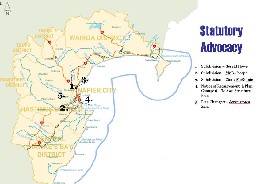
HAWKE’S BAY REGIONAL COUNCIL
Environmental
Management Committee
Wednesday 12 October 2011
SUBJECT: General Business
Reason
for Report
This
document has been prepared to assist Councillors note the General Business to
be discussed as determined earlier in Agenda Item 6.
|
Item
|
Topic
|
Councillor
/ Staff
|
|
1.
|
|
|
|
2.
|
|
|
|
3.
|
|
|
|
4.
|
|
|
|
5.
|
|
|
|
6.
|
|
|
|
7.
|
|
|
|
8.
|
|
|
|
9.
|
|
|
|
10.
|
|
|
NOTE: Hastings
District Council have nearly completed Stage 1 of their Medium Density
Development Strategy (which addresses Action 9 section 5.16 of HPUDS) “to
undertake further work on the intensification targets in order to ‘ground
truth’ capacity of existing urban areas to accommodate the levels envisaged.
This may involve some refinement of the settlement pattern and needs to occur
before specific lines on a map are included in the Regional Policy Statement.”