Meeting of the Environmental Management Committee
Date: Wednesday 10 August 2011
Time: 9.00am
|
Venue:
|
Council Chamber
Hawke's Bay Regional Council
159 Dalton Street
NAPIER
|
Agenda
Item Subject Page
1. Welcome/Notices/Apologies
2. Conflict of Interest Declarations
3. Confirmation of Minutes of the
Environmental Management Committee held on 15 June 2011
4. Matters Arising from Minutes of the Environmental
Management Committee held on 15 June 2011
5. Action Items from Environmental Management Committee
Meetings
6. Call for General Business Items
Decision Items
7. Draft Regional Stormwater Strategy
8. Draft Growth and Infrastructure RPS Change
9. Resource Management Plan Amendment Delegations
10. Special Consultative Process - Navigation Safety Bylaw
Review
11. Special Consultative Process - Dangerous Dams Policy Review
12. Strategic Approach to Wetland Management
Information or Performance Monitoring
13. Dairy Inspection - National Audit
14. Compliance and Enforcement Update
15. Updated Climate Change Predictions for Hawke's Bay
16. Erosion Monitoring
17. Water Meter Regulations Amendment
18. Ruataniwha Groundwater Model Scenarios
19. Regional Resource Management Plan - Plan Effectiveness
Report - Water Quality and Ecology
20. Statutory Advocacy Matters
21. General Business
HAWKE’S BAY REGIONAL COUNCIL
Environmental
Management Committee
Wednesday 10 August 2011
SUBJECT: Action Items from Environmental
Management Committee Meetings
REASON FOR REPORT
1. Items raised at
previous Environmental Management Committee meetings that require actions or
follow-ups are listed on Attachment 1. Each item indicates who is responsible
for follow-up action, when it is expected to be completed and a brief status
comment. Once the items have been completed and/or reported back to the
Committee they will be removed from the list.
DECISION
MAKING PROCESS
2. Council is required to make a decision in accordance with
Part 6 Sub-Part 1, of the Local Government Act 2002 (the Act). Staff have
assessed the requirements contained within this section of the Act in relation
to this item and have concluded that as this report is for information only and
no decision is required in terms of the Local Government Act’s provisions, the
decision making procedures set out in the Act do not apply.
|
RECOMMENDATION
1. That the
Environmental Management Committee receives the report “Action Items from
Environmental Management Committee Meetings”.
|
|

Darryl Lew
Group
Manager Resource Management
|
|
Attachment/s
|
1View
|
Actions from
Previous Environmental Management Committee meetings
|
|
|
|
Actions from Previous Environmental
Management Committee meetings
|
Attachment 1
|
Actions from Environmental Management Meetings
The following is a list of items
raised at Environmental Committee meetings that require actions or follow-ups.
All action items indicate who is responsible for each action, when it is
expected to be completed and a brief status comment for each action. Once the
items have been completed and reported back to the Committee they will be
removed from the list.
15 June 2011
|
Agenda Item
|
Action
|
Person Responsible
|
Due Date
|
Status Comment
|
|
7
|
Proposed Onsite
Wastewater Plan Change
Policy to be developed,
for dealing with consent renewals that fall within the ‘transition’ period
Communication Strategy
to be documented
|
Darryl Lew
|
|
Communication Strategy
developed and emailed to all Councillors on 23 June 2011.
|
|
12
|
Update on Unwanted
Agrichemical Collection Programme
A media
release to be prepared.
|
Darryl Lew
|
|
Media release sent out
Monday 27 June.
|
|
14
|
General Business
Makara Flood Protection
Scheme
An issue of
the scheme being in need of maintenance was raised from within the community.
|
Mike Adye
|
|
Staff have met with the
Makara Scheme liaison committee. Urgent repair work has been completed.
|
|
14
|
General Business
Cartage of silt around
Gibraltar Road
The costs
of carting the silt to the disposal site was raised as an issue from within
the community.
|
Mike Adye
|
|
Staff have worked with
CHBDC staff to resolve silt disposal issues.
|
|
14
|
General Business
Membership of the
Ruataniwha Stakeholder group
There is an apparent
gap in the Tukituki representation on the group, particularly irrigators from
the lower catchment (mid and lower reaches of the river).
|
Andrew Newman
|
|
Ongoing – verbal Update
at meeting
|
13 April 2011
|
Agenda Item
|
Action
|
Person Responsible
|
Due Date
|
Status Comment
|
|
13
|
General Business
Environmental
Awards
Councillors
would appreciate receiving a full report on the recent Ballance and Chamber
of Commerce Awards, including the judging criteria and benefits to Council
from providing support for this event
|
Liz Lambert
|
July2011
|
Memo will be tabled at
this meeting for Councillors information
|
|
|
|
|
|
|
HAWKE’S BAY REGIONAL COUNCIL
Environmental
Management Committee
Wednesday 10 August 2011
SUBJECT: Draft Regional Stormwater Strategy
REASON FOR REPORT
1. This paper presents the
Committee with a draft version of the Regional Stormwater Strategy and seeks
Council’s endorsement of the draft Strategy. If the Council endorses the
Strategy, then it is recommended that the Strategy be opened for public
feedback in parallel to a similar public feedback period associated with draft
changes to the Regional Policy Statement for growth, infrastructure and
unsewered settlements.
BACKGROUND
2. A plan change dealing with stormwater
has been ‘on the books’ since 2004 when the Council decided to withdraw new
stormwater provisions from the then proposed Regional Resource Management Plan
(RRMP). In mid 2009, the Council endorsed establishment of a collaborative
stormwater working group to work through a number of ‘sticky’ unresolved issues
before commencing the RMA’s formal plan change submission process.
Regional Stormwater Working Group (‘the Group’)
3. The stormwater working group met for the
first time in August 2009. The Group consisted of representatives from each
territorial local authority, Fish and Game Hawke's Bay, Department of
Conservation and a cultural representative nominated by the Maori Committee
Chairman. The Group’s purpose was to develop an agreed approach to stormwater
management and produce a Regional Stormwater Strategy. The
current draft Regional Stormwater Strategy is set out in Attachment 1.
4. The Group met initially to definitively
identify regional stormwater issues. The Group agreed that stormwater
discharges do impact receiving environments in terms of water quantity and
water quality and general ecosystem functioning. Section 2 in
the draft Strategy lists additional issues agreed by the Group.
5. To date, collaborative
work of the Group has resulted in the production of a vision, objectives and
overall guiding principles. For the objectives to be achieved, a number of
complementary actions need to be implemented by various organisations. There
is in-principle agreement within the Group on the objectives, key principles
and implementation methods. More recently, some members of the Group expressed
concern that the draft Strategy had not sufficient input from iwi interests.
Iwi Engagement
6. To address the concern
about input of iwi interests in the draft Strategy, Council staff provided a
report to the February 2011 Maori Committee meeting. The report updated
progress of the Strategy and sought the Maori Committee’s views on how to best
engage iwi interests in further preparation of the draft Strategy.
Subsequently, Council staff undertook a series of meetings with regional
taiwhenua representatives to better inform development of the Strategy and to
seek support for the Strategy’s vision and objectives.
7. Overall, most taiwhenua
representatives were supportive of the intent of the Strategy and actively engaged
in the development process. The draft Strategy has been modified where
appropriate to accommodate feedback from taiwhenua representatives.
PURPOSE OF THE REGIONAL STORMWATER STRATEGY
8. The purpose of the
Strategy is to provide a common high-level outline upon which organisations
agree and jointly implement for future management of stormwater in the region.
Objectives that the Group generally has agreed to in-principle are:
8.1. To review the baseline information and
status of stormwater systems and receiving environments;
8.2. To develop a common understanding of
the outcomes to be achieved as a result of improved stormwater management;
8.3. To identify the range of strategies
that could be used to manage stormwater to achieve outcomes;
8.4. To consider the impacts of regional
growth and development in relation to stormwater management particularly in
relation to the Heretaunga Plains Urban Development Strategy.
9. Where relevant,
elements of the draft Strategy are consistent with principles in the recently
adopted Heretaunga Plains Urban Development Strategy. It is also consistent
with the decision on the Hastings District Council’s stormwater discharge
consents. The draft Strategy would also complement the current draft growth
management and infrastructure-related plan changes to the Regional Policy
Statement (see separate reports in 10 August 2011 Environmental Management
Committee agenda).
10. The Strategy itself does
not prescribe rules or a regulatory framework, but does provide an agreed principled
basis upon which a regulatory framework can be developed. Similarly, the
Strategy does not prescribe how stormwater will be managed in location-specific
situations. By reaching preliminary agreement between the parties before a
regulatory framework is developed, it is intended that policy and rules for the
RRMP and RCEP can be crafted in a way to avoid philosophical stand-offs and
minimise points of difference during the RMA plan change process.
11. Some of the
‘sticky’ unresolved issues present in 2009 do remain in dispute. For some
issues, particularly details on degree of regulation and legal interepretation,
the high-level nature of the Strategy was never going to provide the answers,
but the collaborative process of Strategy development has assisted improve
understanding and awareness of the bigger common picture. For example, the
Strategy does not provide a definition of ‘point of discharge’ as that is
something suitably provided in the RRMP and RCEP or if necessary, by legal
opinion on a case by case basis. Another example is the Strategy’s promotion
of an integrated catchment approach to stormwater management. This approach
may involve asset and catchment ‘management plans’, but timing and scope of
such plans remains to be agreed.
NEXT STEPS
12. The Council has
previously agreed that public notification of stormwater-related plan change
provisions be staggered, with the Regional Policy Statement (growth and
infrastructure) provisions to be notified in October 2011 and the regional plan
provisions notified following analysis of submissions received on the RPS
change.
13. If the Council agrees to
endorse the draft Strategy, then the following are proposed as ‘next steps’:
|
Indicative
timeframe
|
|
August -
September
|
The draft Strategy is published
and made available for informal public comment (ie: web-based targeted
consultation with key stakeholders and interested parties) to coincide with
the release of the draft growth and infrastructure RPS change.
|
|
September -
October
|
Policies and rules be drafted
in form of a draft plan change to RRMP and RCEP, based on the principles of
the Strategy.
|
|
October
|
Growth and
infrastructure RPS changes publically notified. Public notification of
stormwater-related regional plan provisions to be staggered as per April 2011
resolution (notification of a stormwater plan change to occur in early 2012).
|
|
October -
November
|
The Stormwater Working Group
to reconvene to consider:
1. the draft policies and rules
for stormwater;
2. any further modifications to
the Strategy arising from public feedback.
3. settlement of any unresolved
issues on the Strategy.
|
DECISION
MAKING PROCESS
14. Council is required to
make a decision in accordance with Part 6 Sub-Part 1 of the Local Government
Act 2002 (the Act). Staff have assessed the requirements contained within this
section of the Act in relation to this item and have concluded the following:
14.1. Sections 97 of the Act do
not apply as these relate to decisions that significantly alter the service
provision or affect a strategic asset.
14.2. Sections 83 and 84
covering special consultative procedure do not apply.
14.3. The decision does not
fall within the definition of the Council’s policy on significance.
14.4. The persons affected by
this decision are all those persons with an interest in the management of
stormwater in the Hawke's Bay region, but nevertheless, they will have
opportunities to make comments and submissions if/when the draft Strategy and
subsequent proposed plan changes are publicly released.
14.5. The options considered in
relation to advancing the draft Changes were (1) to seek Council endorsement of
the draft Strategy before further community engagement; (2) proceed with wider
community engagement without initial Council endorsement of the draft Strategy;
(3) proceed with final drafting of the Strategy without any wider community
engagement; (4) adopt the Strategy as something akin to a ‘memorandum of
understanding’ and suggest members of Regional Stormwater Working Group also do
likewise.
14.6. Section 80 of the Act
covering decisions that are inconsistent with an existing policy or plan does
not apply.
14.7. Council can exercise its
discretion under Sections 79(1)(a) and 82(3) of the Local Government Act 2002
and make decisions on this issue without conferring directly with the community
and persons likely to be affected by or to have an interest in the decision
because the Resource Management Act allows people to have an opportunity to
submit on a future proposed plan change following a decision by Council to
publicly notify it.
|
RECOMMENDATIONS
The
Environmental Management Committee recommends that Council:
1. Agrees that the decisions to be made
are not significant under the criteria contained in Council’s adopted policy
on significance and that Council can exercise its discretion under Sections
79(1)(a) and 82(3) of the Local Government Act 2002 and make decisions on
this issue without conferring directly with the community and persons likely
to be affected by or to have an interest in the decision due to the nature and significance of the issue to be considered
and decided.
2. Endorse the draft ‘Regional Stormwater Strategy’ (set
out in attachment 1) with or without amendments.
3. Instruct staff to undertake further community engagement on
the draft Regional Stormwater Strategy in conjunction with engagement
associated with draft Growth and Infrastructure changes to the Regional
Policy Statement. Engagement should include the following initiatives:
3.1. opportunity
for general public input for three week period in August/September;
3.2. media
release and promotion of draft Regional Stormwater Strategy on
Council’s website; and
3.3. targeted
promotion of draft Regional Stormwater Strategy with key stakeholders
(for example: NZTA, DHB Public Health Unit).
|
|

Esther-Amy Bate
Planner
|

Gavin Ide
Team Leader Policy
|
|

Helen Codlin
Group
Manager
Strategic
Development
|
|
Attachment/s
|
1View
2
|
Draft
Regional Stormwater Strategy
Implementation
Matrix
|
|
|
|
Draft Regional Stormwater Strategy
|
Attachment 1
|
Draft Regional
Stormwater Strategy
April 2011
1. Introduction
& Scope
Introduction
The Stormwater
Working Group was established with the following overall project goal:
To Reach Agreement
on How Stormwater Should Be Managed in the Hawke’s Bay Region.
|
|
Its
objectives:
· To review the baseline information and
status of stormwater systems and receiving environments.
· To develop a common understanding of
the outcomes to be achieved as a result of improved stormwater management
· To identify the range of strategies
that could be used to manage stormwater to achieve agreed outcomes.
· To consider the impacts of regional
growth and development in relation to stormwater management particularly in
relation to the Heretaunga Plains Urban Development Strategy.
· To recommend an agreed regional
stormwater strategy and present it to a joint workshop of Councils.
Scope
of Regional SW Strategy
The Regional
Stormwater Strategy is a strategic document for the management of stormwater
within the Hawke’s Bay Region. The strategy provides a non-statutory framework
from which to address a range of water quantity and quality, and environmental
issues in a coordinated, integrated and prioritised manner.
Purpose
of Regional SW Strategy
1. Coordinate the operations of the Local and Regional Authorities
to achieve an integrated approach to the management of stormwater quantity and
quality.
2. Communicate a regional approach to key stakeholders to facilitate
improved management of stormwater quantity and quality throughout the Region.
2. Issues
Stormwater
discharges impact the receiving environment in two main ways. Firstly they
increase the volume and rate of water movement causing scouring of the channel
and flooding. Secondly having been mobilised by stormwater runoff,
contaminants accumulate within the receiving environment. The result therefore
is a gradual decline in the health of the receiving environment. Consequential
adverse effects of this decline are social, cultural, economic and
environmental.
The following
table highlights a number of stormwater issues that this strategy seeks to
address.
|
Issue
|
Explanation
|
|
People
|
Public health and wellbeing
|
|
|
Food source and cultural harvesting
(watercress, koura and mahinga kai)
|
|
|
Recreation
|
|
|
Mauri
|
|
|
Potential for re-use for drinking,
industrial, commercial, irrigation and amenity enhancement
|
|
Loss of
Habitat & Biodiversity
|
Reduced riparian vegetation
(sedimentation, temperature)
|
|
|
Loss of vegetation in catchment
affects hydrology (sedimentation, quantity)
|
|
|
Stream Connectivity (ecology, migration,
increased impermeable surfaces)
|
|
|
Altered salinity regimes in marine
environments
|
|
Contamination
of Stormwater
|
Discharge from onsite wastewater
disposal systems
|
|
|
Discharges from industrial,
commercial and domestic activities
|
|
|
Zoning of development
|
|
|
Agriculture & horticultural
runoff (fertiliser, pesticides and insecticides)
|
|
|
Runoff from industrial and
commercial sites
|
|
|
Sedimentation
|
|
|
Impervious surfaces (car parks,
roads and other paved surfaces)
|
|
Flooding
|
Risk to human health and property
|
|
|
Risk to human life and other life.
|
|
|
Costs of clean up and repair to
public and private sector
|
|
Erosion and
land instability
|
High sediment release potential
|
|
|
Increased stormwater flow
|
|
|
Stream bank erosion
|
|
|
Risk to established development
|
|
Stormwater Management
|
Must expand to address quantity and
quality issues
|
|
|
Address source controls (Low Impact
Design)
|
3.
Less
Flooding
Reduced
Contamination
Improved
Environments
Resilient
Communities
|
|
Vision
In 50 years time:
1. Drought and
rain events have increased in severity and frequency. The communities of
Hawke’s Bay are resilient against flooding and drought. Stormwater is
recognised as a valuable resource.
2. Communities in
Hawke’s Bay have access to numerous resilient and healthy surface water
ecosystems. Riparian planting shades abundant in-stream life. Waterways and
their margins are valued by the community for recreation and leisure.
3. The community
values local government as a partner and leader in sustainable, practical and
cost effective stormwater management. Regional policy and regulation is highly
integrated and responsive to social, cultural, economic and environmental
needs.
4. Objectives
|
1. Systems:
|
Agree that stormwater will be
managed taking into account the needs of people and communities, natural and
physical resources, amenity values, social and cultural values and asset
management.
|
|
2. People:
|
To ensure that the adverse
effects of stormwater on social, cultural, environmental and economic
wellbeing are avoided, remedied or mitigated.
|
|
3. Environment:
|
To ensure that the integrity,
functioning, resilience and intrinsic value of freshwater and marine
ecosystems is not compromised by the adverse effects of stormwater.
|
|
4. Asset
Management:
|
Provide for the integrated and
comprehensive management of stormwater through appropriately maintained
assets.
|
5. Goal
for Stormwater Management
|
|
Stormwater
in the Hawke’s Bay region is managed using comprehensive, catchment based,
Stormwater Management Plans that optimise the protection of people, property,
culture, and ecosystems while efficiently supporting economic activity.
|
|
6. Key
Principles
A. Social
Wellbeing
1. Recognise
that the community has a right to safe enjoyment of contact recreational
activities and harvesting of food in freshwater and marine environments.
2. Recognise the
intrinsic value of natural environments on social wellbeing.
B. Cultural
Wellbeing
1. Establish and
maintain partnerships with iwi as kaitiaki of the region’s land and water
resources.
2. Acknowledge
the relationship Maori has with water and water bodies and the potential impact
on mauri from stormwater discharges.
C. Environmental
Wellbeing
1. The retention
and restoration of open watercourses should be considered in preference to
piping.
2. Consider
stormwater management as part of total land and water resource management.
3. Stormwater
discharges shall not compromise the potability of ground water.
4. The adverse
effects of stormwater on land resources and property, such as flooding or
erosion or land slippage are minimised.
5. Recognise the
benefits of Low Impact Design stormwater solutions.
6. Recognise
that some receiving environments are more sensitive to stormwater discharges
than others.
7. Recognise
that ecosystems have natural function and intrinsic value.
D. Economic
Wellbeing
1. Develop
integrated Stormwater Management Plans for stormwater management which includes
enhancement of the built environment.
2. Consider
stormwater as a resource and seek constructive, practical opportunities for
reuse.
3. Recognise
that ecosystem function contributes to economic wellbeing (e.g. water
regulation, erosion control, nutrient cycling etc).
4. Recognise and
plan for stormwater issues in the land use planning process.
5. Ensure
solutions are practical, adaptive and provide value for the rate payers’ money
and if possible provide multi value solutions
6. Plan for the
impacts of Climate Change on stormwater management.
7. Maximise
inter-council co-operation.
References
Auckland
Regional Council. (July 1998) Auckland Region Urban Stormwater Management
Project Strategy Statement. Auckland, NZ: ARC.
Auckland
Regional Council. (May 1995) The Environmental Impacts of Urban Stormwater
Runoff. ARC
Technical Publication No. 53. Auckland, NZ:ARC.
Auckland Regional Council. (May 2004) An Action
Plan to Deliver Improved Stormwater
Outcomes: Final Report. Auckland, NZ: ARC.
Chandra,
V. for City Design. (March 2005) Stormwater Contaminant Effects: Review of
available information and its relevance to Hawke’s
Bay. Napier, NZ: HBRC.
Hawke’s Bay Regional Council (June 2004) Te Karamu
Catchment Review and Options for
Enhancement. Napier,
NZ: Asset Management/Engineering Section Environmental Management Group, HBRC.
Hawke’s
Bay Regional Council (2006) Hawke’s Bay Regional Resource Management
Plan (including
the Regional Policy Statement).
Napier, New Zealand: HBRC.
Hawke’s Bay Regional Council (March 2006) Update on
Stormwater Policy Review to
the HBRC Environmental Management
Committee. Napier, NZ: Policy, HBRC.
Hawke’s Bay Regional Council (May 2007) Recreational
Water Quality in Hawke’s Bay:
Review of the 2006-2007 Recreational
Water Quality Monitoring Programme. Napier,
NZ:
Environmental Management Group Technical
Report ISSN 1174 3077, EMT 07/03 HBRC Plan
No. 3937: HBRC
Hawke’s Bay Regional Council (June 2007) Stormwater
Discharge Draft Provisions
Workshop Napier, NZ: Policy, HBRC
Hawke’s Bay Regional Council (October 2007) Background/
Progress Report Napier,
NZ: Policy, HBRC.
New
Zealand Legislation. (2007) Resource Management (National Environmental
Standards
for Sources of Human Drinking Water) Regulations 2007. Wellington, NZ: New Zealand Government.
Resource
Management Act 1991 (2005)
Wellington, New Zealand: Brookers Ltd.
White,
S. E. for Bioresearchers Ltd (July 2004) Ahuriri Estuary Environmental
Evaluation
for Hawke’s Bay Regional Council. Napier, NZ: EMI 0422 HBRC Plan No. 3503.
|
Draft
Regional Stormwater Strategy
|
Attachment 2
|
Implementation Matrix
|
|
|
Key Outcomes
|
Organisation
|
Mechanisms
|
|
Methods
|
|
Actions
|
Less Flooding
|
Reduced Contamination
|
Improved Environment
|
Resilient Communities
|
Local Authority
|
Regional Council
|
Other
|
Regional Resource Management Plan
|
District Plan
|
Bylaws
|
Regional Stormwater Strategy
|
Community Education Strategies
|
Your Choice Stormwater Education
|
Treaty Settlements
|
Hapu Management Plan
|
Maori Committee
|
Hawke’s Bay Waterways Design Guidelines
|
Asset Management Plans
|
Stormwater Management Plans
|
Catchment Modelling
|
Design Codes
|
State of the Environment
|
Research & Investigation
|
|
Education
|
E1
|
Co-ordinate
the development of targeted rural and urban education packages
|
|

|
|
|
|
|
|
|
|
|
|
|
|
|
|
|
|
|
|
|
|
|
|
|
E2
|
Promote
Low Impact Design stormwater solutions
|
|
|
|
|
|
|
|
|
|
|
|
|
|
|
|
|
|
|
|
|
|
|
|
|
E3
|
Highlight
stormwater issues & promote better community understanding of issues
& solutions.
|
|
|
|
|
|
|
|
|
|
|
|
|
|
|
|
|
|
|
|
|
|
|
|
|
E4
|
Encourage
partnerships with communities in managing waterways.
|
|
|
|
|
|
|
|
|
|
|
|
|
|
|
|
|
|
|
|
|
|
|
|
|
Partnerships
|
P1
|
Establish
and maintain partnerships with tangata whenua as kaitiaki of the region’s
land and water resources.
|
|
|
|
|
|
|
|
|
|
|
|
|
|
|
|
|
|
|
|
|
|
|
|
|
P2
|
Ensure
continued involvement off all stakeholders to achieve a multi-disciplinary,
co-ordinated approach to address all aspects of stormwater management
|
|
|
|
|
|
|
|
|
|
|
|
|
|
|
|
|
|
|
|
|
|
|
|
|
P3
|
Engage
with industry & commercial parties to develop appropriate industry
standards which include environmental management practices at source.
|
|
|
|
|
|
|
|
|
|
|
|
|
|
|
|
|
|
|
|
|
|
|
|
|
Policy &
Regulation
|
R1
|
Develop
an integrated catchment approach to stormwater management that encourages
sustainable rural landuse practices.
|
|
|
|
|
|
|
|
|
|
|
|
|
|
|
|
|
|
|
|
|
|
|
|
|
R2
|
Consider Low Impact Design mechanisms first when assessing the
best practicable option in stormwater management.
|
|
|
|
|
|
|
|
|
|
|
|
|
|
|
|
|
|
|
|
|
|
|
|
|
R3
|
Recognise
that some receiving environments are more sensitive to the effects of stormwater
than others.
|
|
|
|
|
|
|
|
|
|
|
|
|
|
|
|
|
|
|
|
|
|
|
|
|
R4
|
Reduce
the effects of point & non-point source contamination.
|
|
|
|
|
|
|
|
|
|
|
|
|
|
|
|
|
|
|
|
|
|
|
|
|
R5
|
Avoid
connections to and discharging into municipal systems unless criteria is met.
|
|
|
|
|
|
|
|
|
|
|
|
|
|
|
|
|
|
|
|
|
|
|
|
|
R6
|
Use statutory documents to require the implementation of the
principles of the Hawke’s Bay Regional Council Waterways Guidelines.
|
|
|
|
|
|
|
|
|
|
|
|
|
|
|
|
|
|
|
|
|
|
|
|
|
R7
|
Encourage the rehabilitation of existing urban catchment and avoid
further degradation.
|
|
|
|
|
|
|
|
|
|
|
|
|
|
|
|
|
|
|
|
|
|
|
|
|
R8
|
Develop an enforcement programme to discourage potential
polluters
|
|
|
|
|
|
|
|
|
|
|
|
|
|
|
|
|
|
|
|
|
|
|
|
|
Investigation
|
I1
|
Keep
up to date with current knowledge and research and where necessary consider
joint initiatives.
|
|
|
|
|
|
|
|
|
|
|
|
|
|
|
|
|
|
|
|
|
|
|
|
|
I2
|
Improve
monitoring of stormwater quality to better characterise contaminant loads and
build up more robust baseline data to inform policy and regulation.
|
|
|
|
|
|
|
|
|
|
|
|
|
|
|
|
|
|
|
|
|
|
|
|
|
|
|
|
|
|
|
|
|
|
|
|
|
|
|
|
|
|
|
|
|
|
|
|
|
|
|
|
HAWKE’S BAY REGIONAL COUNCIL
Environmental
Management Committee
Wednesday 10 August 2011
SUBJECT: Draft Growth and Infrastructure RPS
Change
REASON FOR REPORT
1. This report presents
the Committee with draft versions of two plan changes to the Regional Policy
Statement (RPS).
2. The first draft Change
relates to the ‘built environment’ and contains provisions for sustainable
urban growth and integrated use and development of infrastructure. Preparation
of this Change was a specific action required for implementation of the
Heretaunga Plains Urban Development Strategy (HPUDS). The draft Change also
includes a limited number of provisions that are relevant to those parts of the
region outside the Heretaunga Plains ‘sub-region.’
3. The second and more
succinct draft Change includes provisions improving management of cumulative
effects of wastewater systems in existing unsewered communities. A key feature
of this draft Change is the proposed ‘targeted rate or similar’ method for fund
associated audit monitoring and any further investigative work into wastewater
management risks and options for existing unsewered communities.
4. Staff recommend that
both draft Changes be endorsed by Council and released for informal public
comment (in a similar fashion to release of the draft onsite wastewater change
earlier this year). Any public feedback would then be incorporated into
further revisions to the draft Changes in time for possible public notification
as proposed plan changes in October 2011.
Background
5. The draft ‘Growth
Change’ is one of over 60 actions for implementation of the Heretaunga Plains
Urban Development Strategy (HPUDS). Changing the RPS is likely to be the most
significant implementation action for which the Regional Council is the lead
agency and timing was specified as being 2011. In full, the action stated in
HPUDS was:
“prepare a change to the RPS which will
provide specific guidance on where growth will occur and include the concept of
urban limits. The change will determine the overall extent of HPUDS through
setting urban limits and working towards specific rather than indicative lines
on the map:
- greenfield growth areas;
- rural residential – a list of criteria for assessing
the location and form will be included;
- intensification areas;
- coastal settlements – taking into account coastal
hazards and areas of significant natural coastal character;
- other matters as agreed;
- identification of the significant issues for the
Heretaunga Plains such as large footprint retail/commercial/ industrial land
outside of the growth areas and the expansion of existing settlements;
- the RPS change is to assist in discouraging any
proposed plan changes and resource consent applications for retail/industrial
land that is outside of the agreed Heretaunga Plains settlement pattern.”
6. Opus International
Consultants Limited were engaged to draft a plan change to the RPS to
incorporate relevant elements of HPUDS. The Growth Change was drafted to also
include region-wide provisions, so in addition to meeting with relevant staff
representatives from Napier City and Hastings District councils, discussions
have also occurred with relevant staff of Wairoa and Central Hawke’s Bay
district councils. Feedback from those meetings have been incorporated and
these have also been reviewed by the HPUDS Core Technical Advisory Committee.
7. For several years now,
the Council has been investigating ways for regional planning documents to
better address the cumulative adverse effects of wastewater discharges. These
cumulative adverse effects or potential effects are typically associated with
existing unsewered coastal and inland settlements.
Draft Growth Plan Change
8. The draft Growth Change
is set out in Attachment 1. Inclusion of extended explanations are deliberate
for this draft document, but these explanations are likely to be removed from a
publicly notified Proposed Change and instead featured in an accompanying ‘s32
evaluation summary report.’
9. For now, the draft
Growth Change is effectively a ‘bundle’ of amendments covering a variety of
themes. The predominant themes include:
9.1. embedding principles and
direction of HPUDS into the RPS (these include greater clarity and direction
regarding urban limits; protection of versatile soils; integration of
development and infrastructure; papakainga housing, compact city philosophy and
urban form, etc);
9.2. integrated
decision-making, particularly in relation to structure plans for further
subdivision, use and development and provision of adequate infrastructure;
9.3. integration of urban
stormwater management and discharges;
9.4. integration of
non-reticulated wastewater treatment and disposal;
9.5. clarity of references
and concept of ‘versatile land’ as highlighted through preparation of HPUDS;
9.6. a range of generic principles
(applicable region-wide, and not only Heretaunga Plains specific), to guide
good integrated and sustainable development; and
9.7. giving effect to
national policy statements where relevant.
10. The draft Growth Change
does not map ‘urban limits.’ Representatives of Napier City and Hastings
District councils favoured this approach where the RPS would not map limits,
while still enabling district plans to map such urban limits and adapt those
limits over time to accommodate findings of future HPUDS implementation
monitoring. The provisions for urban limits are not proposed to apply in
Wairoa and Central Hawke's Bay districts.
11. Being a change to the
RPS, territorial authorities will have to give effect to the amended RPS
through their respective district plans. They will also have to have regard to
the amended RPS when considering resource consent applications and the like.
Draft Wastewater Plan Change
12. The draft Wastewater
Change is set out in Attachment 2. This is not as comprehensively developed,
nor lengthy, as the draft Growth Change but nevertheless, both draft changes
complement the other. This draft Change is quite distinct from Change 3 and
Variation 3 which were the recently notified proposing amendments to rules for
onsite wastewater discharges.
13. The draft provisions
build on the concept of the accreditation scheme and audit monitoring that is
being established for current consent and compliance monitoring activities.
The result of the monitoring will be used to determine whether further
investigation is required. The proposed methods indicate that if a community
is identified as needing further investigation, that this will be indicated
through the Annual Plan consultation process.
14. The key provision that
staff are seeking early feedback on is the proposed funding mechanism to fund
the monitoring and investigations. A targeted rate would apply to both existing
systems currently authorised by a permitted activity rule and those requiring
consent. This puts both existing and new discharges on the same footing in
terms of audit monitoring and the costs associated with it, therefore
addressing cost inequity issues.
15. No detailed work has
been undertaken as yet regarding the specifics of such a rate, such as should
the rates be pooled as a region-wide scheme for use in targeted investigations,
how many ratepayers might be affected and how much the rate might be. Neither
has any work yet been undertaken on how much the implementation of such a
policy may cost.
16. Alternative policy
approaches to addressing the inequity include requiring all discharges in
unsewered communities to require a resource consent or keeping the status quo.
Costs and benefits of these options also need to be considered alongside the
draft policy.
17. This draft Wastewater
Change has to date only been circulated internally amongst consents and
compliance teams. Staff plan to discuss these draft policy provisions with
city and district council staff and the wastewater industry sector. However,
as funding is a key element of this policy approach, staff considered it
prudent to seek Council comment early.
18. The Wastewater Change is
also drafted as a change to the RPS so TLAs will be obliged to consider its
relevance in their decision-making.
Community engagement the Growth and Infrastructure Plan
Change
19. Previous briefing papers
on plan change work programmes have indicated October 2011 as a timeframe for
coordinated notification of a Growth and wastewater plan changes. Staff
consider this timeframe is still achievable.
20. As noted above, the
draft Changes incorporate feedback from each of the territorial authorities.
The Hawke's Bay Triennial Agreement specifies protocols for preparation and
review of the RPS. Because the draft Changes largely embeds principles arising
from earlier joint-council work (ie: HPUDS), the protocols are relatively
easily fulfilled.
21. The preparation of HPUDS
itself involved several opportunities for public input into the way future
growth in the Heretaunga Plains sub-region might be managed. The draft Changes
are not revisiting HPUDS’s principles and actions – merely implementing
relevant elements of the strategy. Consequently, any further community
engagement on the draft Changes can be relatively focussed.
22. Staff recommend that the
Council endorse the draft Changes so that further community engagement can take
place.
Next steps
23. If the Council agrees to
endorse the draft Changes (with or without amendments), the staff will
undertake a wider community engagement. That wider engagement process is
envisaged to be in a manner similar to the recently notified onsite wastewater
plan change. Community engagement would involve inviting public comments over
a three week period in August/September. During this time, staff would also
target additional key stakeholders (for example: NZTA, HB Primary Producers
Roundtable, Chamber of Commerce and others who made submissions on the HPUDS).
The HPUDS ‘Reference Group’ could also be re-assembled as a forum for seeking
feedback. General public comment will be invited through a media release and
promotion on Council’s website.
24. Staff would compile and
summarise comments received and any recommended revisions to be made to the
draft Changes. Those comments will be used to improve the draft Changes in
preparation for presentation to Council on 26th October (standing
committee meeting on 12th October) for possible adoption as proposed
Changes.
25. In addition to broad and
targeted community engagement, staff propose the draft Changes being reviewed
subject to a legal review and independent planner before being finalised.
Other matters to consider
26. Reporting to one of
Council’s committees prior to the Council meeting in October is currently
uncertain while terms of reference for committees are being reviewed and also
awaiting constitution of the Regional Planning Committee (RPC). Given the
relatively advanced form of the draft Changes, it may be appropriate that the
final draft Changes be reported directly to Council rather than via the RPC -
even if the RPC is constituted before October. Staff seek advice on this
matter.
DECISION MAKING PROCESS
27. Council is required to
make a decision in accordance with Part 6 Sub-Part 1 of the Local Government
Act 2002 (the Act). Staff have assessed the requirements contained within this
section of the Act in relation to this item and have concluded the following:
27.1. Sections 97 of the Act do
not apply as these relate to decisions that significantly alter the service
provision or affect a strategic asset.
27.2. Sections 83 and 84
covering special consultative procedure do not apply.
27.3. The decision does not
fall within the definition of the Council’s policy on significance.
27.4. The persons affected by
this decision are all those persons with an interest in the region’s built
environments and infrastructure, but nevertheless, they will have opportunities
to make comments and submissions when the draft and subsequent proposed plan
changes are publicly released.
27.5. The options considered in
relation to advancing the draft Changes were (1) to seek Council endorsement of
the draft Changes before further community engagement; (2) proceed with wider
community engagement without initial Council endorsement of the draft
provisions; and (3) proceed with final drafting of the Changes without any
wider community engagement on the plan changes.
27.6. Section 80 of the Act
covering decisions that are inconsistent with an existing policy or plan does
not apply.
27.7. Council can exercise its
discretion under Sections 79(1)(a) and 82(3) of the Local Government Act 2002
and make decisions on this issue without conferring directly with the community
and persons likely to be affected by or to have an interest in the decision
because the Resource Management Act allows people to have an opportunity to
submit on a future proposed plan change following a decision by Council to
publicly notify it.
|
RECOMMENDATIONS
That the
Committee recommends Council:
1. Agrees that the decisions to be made
are not significant under the criteria contained in Council’s adopted policy
on significance and that Council can exercise its discretion under Sections
79(1)(a) and 82(3) of the Local Government Act 2002 and make decisions on
this issue without conferring directly with the community and persons likely
to be affected by or to have an interest in the decision because the Resource Management Act
allows people to have an opportunity to submit on a future proposed plan
change following a decision by Council to publicly notify it.
2. Endorse the draft plan change for ‘urban growth and
strategic integration of infrastructure’ (set out in attachment 1) with
or without amendments.
3. Instruct staff to undertake further community engagement on
the draft plan change for ‘urban growth and strategic integration of
infrastructure’ with that engagement including the following initiatives:
3.1. opportunity
for general public input for three week period in August/September;
3.2. media
release and promotion of draft Changes on Council’s website;
3.3. targeted
promotion of draft Changes with key stakeholders (for example: NZTA, Chamber
of Commerce, DHB Public Health Unit, and reassembly of the HPUDS ‘reference
group’); and
3.4. targeted
promotion of draft Changes to persons who made submissions on HPUDS.
4. Support in principle the draft plan change for ‘Existing
unsewered settlements’ (set out in attachment 2) with or without
amendments, subject to a full analysis of implementation costs and funding
mechanisms.
|
|
Gavin Ide
Team Leader Policy
|

Helen Codlin
Group
Manager
Strategic
Development
|
Attachment/s
|
1View
|
Built
Environment - Final draft
|
|
|
|
Built Environment - Final draft
|
Attachment 1
|

Managing the Built
Environment
Urban Development and the Strategic Integration of
Infrastructure
ISSUES
ISS
UD1 The adverse effects of sporadic and unplanned urban development
(particularly in the Heretaunga Plains sub-region), on:
a) the
natural environment (land and water);
b) the
efficient operation, maintenance and upgrading of physical infrastructure or
services (particularly strategic infrastructure); and
c) the economic,
cultural and social wellbeing of the Region’s people and communities.
Explanation
Unplanned
urban form and ad hoc management of urban growth can have adverse effects on
people and communities, and on the natural environment (soils and water).
Effective management of growth in the region is necessary to ensure development
occurs in a planned, sustainable manner and in a way that also does not
compromise the planned provision, operation, maintenance and upgrading of regionally
significant infrastructure. This aligns with the statutory functions of the
Regional Council in giving effect to the Act as contained in section 30 of the
Resource Management Act 1991 – in particular:
“(c) the
control of the use of land for the purpose of—
(i) soil
conservation:
(ii) the
maintenance and enhancement of the quality of water in water bodies and coastal
water:
(iii) the
maintenance of the quantity of water in water bodies and coastal water:
(iiia) the
maintenance and enhancement of ecosystems in water bodies and coastal water:
(iv) the
avoidance or mitigation of natural hazards:
(f) the
control of discharges of contaminants into or onto land, air, or water and
discharges of water into water:
(gb) the
strategic integration of infrastructure with land use through objectives,
policies, and methods;”
Managing
urban growth and development is a regionally significant issue because what
occurs in one area will invariably have an effect on other places. This is
particularly so for the urban centres of Napier and Hastings, and surrounding
coastal and rural settlements in and around the Heretaunga Plains. Up to 8,000
households are projected to be required between 2012 and 2045 in the Heretaunga
Plains area. Growth in the other parts of the Region is not projected to be
significant over that period.
Managed
growth intervention recognises the actual or potential effects urban growth can
have on people and communities, and the important role that efficient
infrastructure (e.g. road, rail, ports, airports, electricity networks,
telecommunications, drainage, dams, water and wastewater networks) plays in
supporting settlement growth and prosperity. The protection of the region’s
strategic infrastructure is essential for growth. A lack of integration between
land use and infrastructure can result in poor infrastructure investment
decisions, public funding pressures and inefficient land use patterns.
In
the past, Hastings and Napier have planned for growth independently. However,
in recognising the interrelationship of these key urban centres, and the
pressures on shared resources and infrastructure, Hawke’s Bay Regional Council,
Hastings District Council and Napier City Council embarked on a collaborative
approach to urban growth and development out to 2045, culminating in the
development of the Heretaunga Plains Urban Development Strategy (HPUDS)[1].
The
purpose of the Heretaunga Plains Urban Development Strategy is to assist, in a
collaborative manner, the local authorities to plan and manage growth on the
Heretaunga Plains and some additional coastal communities beyond the immediate
Heretaunga Plains. The Strategy takes a long-term approach to addressing the
key issues facing the Heretaunga Plains in a more integrated way, and focuses
on a preferred settlement pattern that will lead to more compact development
through gradual restriction on urban boundaries to allow for proper planning
and design work.
The
Regional Policy Statement seeks to give effect to the general tenets of HPUDS
at the regional level, where the outcomes of the HPUDS process align with the
statutory functions of the Regional Council.
Much
of the urban growth policy in the Regional Policy Statement is therefore
directed at a sub-regional level to the Heretaunga Plains and surrounding coastal
and rural settlements. The Wairoa and Central Hawke’s Bay Districts, and
Hastings District hinterland, have different pressures, which warrant less
regional policy direction in terms of urban growth management at this time.
This may change over time, requiring further regional policy intervention at a
later date.
For
the purposes of the Regional Policy Statement, the Heretaunga Plains sub-region
is geographically defined in Appendix Xa, matching the geographical extent
adopted for HPUDS and the Heretaunga Plains Transportation Strategy.
ISS UD2 The
adverse effects from urban development encroaching on versatile land
(particularly in the Heretaunga Plains sub-region where the land supports
regionally and nationally significant intensive economic activity), and
ultimately the adverse effects of this on the economic wellbeing of the
Region’s people and communities both now and for future generations.
Explanation
The Heretaunga Plains sub-region
contains areas with a high proportion of very high value versatile land. There
are competing demands for this valuable finite resource. The diversity and
intensity of horticultural and viticultural production on the Heretaunga
Plains, for instance, creates a high demand for land which is in short supply,
whilst the same land is highly desirable for urban and rural lifestyle
development.
The versatile land of the Heretaunga
Plains is a regionally, if not nationally, significant resource for primary
production and ultimately underpins the economy of the Region. Therefore,
pressure from urban development encroaching on this resource is a regionally
significant issue.
Urban expansion on to agricultural
land continues unless controlled, because the financial incentives are strong.
The increased market value of land developed for urban use is considerable and
beyond agricultural returns to sustain. Once developed, the economic value of
urban and industrial infrastructure normally means this land is permanently
removed from primary production. In short, within agriculture, land use
conflicts occur around short-term economic incentives and the future
sustainability of the soils. Subdivision for urban development removes land
from agricultural production but also impacts on the productivity of other
land, in particular through reverse sensitivity.
The concentration of highly versatile
soils in conjunction with significant concentration of the Region’s population
on the Heretaunga Plains, reinforces the focus of urban growth policy in the
Regional Policy Statement on the Heretaunga Plains sub-region at this time.
OBJECTIVES
OBJ
UD1 URBAN FORM (REGION)
Establish compact,
well-designed, and strongly connected urban form throughout the Region, that:
a) achieves
quality built environments that:
- provide
a range of housing choices and affordability,
- have
a sense of character and identity,
- retain
heritage values and values important to tangata whenua, and
- that
are healthy, environmentally sustainable, functionally efficient, and
economically and socially resilient;
b) minimises
reverse sensitivity effects at the urban/rural interface;
c) minimises
reverse sensitivity effects on existing strategic and other physical
infrastructure;
d) avoids
unnecessary encroachment of urban activities on the versatile land of the
Heretaunga Plains;
and
e) avoids or
mitigates increasing the frequency or severity of risk to people and property
from natural hazards.
Principal
Reasons and Explanation
A
sprawling uncontrolled pattern of development does not promote sustainable
forms of development and promotes less efficient use of existing
infrastructure. High levels of amenity, quality living environments, and
retention of significant features and values are harder to achieve when
development is not well designed and connected. Sprawling development also
leads to unsustainable encroachment onto versatile land which underpins much of
the Region’s economy. Transitioning to a more compact, well-designed and
strongly connected urban form better supports the economic, social and cultural
wellbeing of the Region’s people and communities.
[Refer also:
· OBJ7 and OBJ8 (Chapter 3.2 – Coastal Resources) re:
coastal values important to tangata whenua, and development in coastal hazard
areas
· OBJ16 and OBJ18 (Chapter 3.5 – Conflicting Land Uses)
re: nuisance effects from location of conflicting land uses
· OBJ31 (Chapter 3.12 – Natural Hazards) re: natural
hazards
· OBJ36 and OBJ37 (Chapter 3.14 – Matters of Significance
to Iwi/Hapu) re: values important to tangata whenua]
OBJ
UD2 INTENSIFICATION (HERETAUNGA PLAINS SUB-REGION)
Provide
for residential growth in the Heretaunga Plains sub-region through higher
density development.
Principal
Reasons and Explanation
New
development accommodates growth and provides the opportunity to enhance the
quality of the environment. More intensive forms of development promote
efficient use of existing infrastructure, minimise energy use (as development
spreads, the demand for transport and energy use increases), and reduce the
need to encroach onto the versatile land of the Heretaunga Plains.
OBJ
UD3 PROVISION FOR BUSINESS LAND (HERETAUNGA PLAINS SUB-REGION)
Identify
and provide for the land requirements for the growth of business activities in
the Heretaunga Plains sub-region in a manner that supports the settlement
pattern promoted in OBJ UD1.
Principal
Reasons and Explanation
The
provision of adequate land for future business activities is important for long
term economic growth and the provision of both employment and services to the
sub-region’s existing and future communities.
OBJ
UD4 PLANNED PROVISION FOR URBAN DEVELOPMENT (HERETAUNGA PLAINS
SUB-REGION)
Enable
urban development in the Heretaunga Plains sub-region, in an integrated,
planned and staged manner, which allows for the adequate and timely supply of
land and associated infrastructure.
Principal
Reasons and Explanation
Successful
long term growth management is dependent on integrating long term land use, the
infrastructure necessary to support this and the ability to fund and supply the
infrastructure in a timely and equitable manner.
OBJ
UD5 INTEGRATION OF LAND USE WITH SIGNIFICANT INFRASTRUCTURE (REGION)
Ensure
through long-term planning for land use change throughout the Region, that the
rate and location of development is integrated with the provision of strategic
and other infrastructure, the provision of services, and associated funding
mechanisms.
Principal
Reasons and Explanation
Strategic
infrastructure in the wider region is essential to the well-being, health and
safety of people and communities. Consideration needs to be given to sequencing
and costs of infrastructure development in decision making. These can have
significant effects on efficiency and the economic well-being of communities.
Recognition of the importance of strategic infrastructure will lead to greater
weight being given to its requirements and the desirability to reduce
incompatibility and conflicts.
OBJ
UD6 INTEGRATION OF TRANSPORT INFRASTRUCTURE WITH DEVELOPMENT
(REGION)
Ensure that the
planning and provision of transport infrastructure is integrated with
development and settlement patterns and facilitates the movement of goods and
provision of services throughout the Region, while:
a) limiting
network congestion;
b) reducing
dependency on private motor vehicles;
c) reducing
emission of contaminants to air and energy use; and
d) promoting the
use of active transport modes.
Principal
Reasons and Explanation
Development
that is not well integrated with transport infrastructure can result in
increased car dependency, higher energy use, greater traffic volumes, and
inefficient freight movement. Land use patterns that are integrated with
transport infrastructure minimise energy use through network optimisation, and
enables greater recognition of the importance of strategic transport networks
in supporting the economic and social wellbeing, and health and safety, of
people and communities.
[Refer also OBJ32 and OBJ33 (Chapter 3.13 –
Maintenance and Enhancement of Physical Infrastructure) re: recognising and
providing for operation, maintenance and development of physical
infrastructure, and specific locational requirements]
POLICIES
CONTAINMENT
OF URBAN ACTIVITIES (HERETAUNGA PLAINS SUB-REGION)
POL UD1 URBAN
CONTAINMENT
In providing for
urban activities in the Heretaunga Plains sub-region, territorial authorities
must place priority on:
a) the
retention of the versatile land of the Heretaunga Plains for existing and
foreseeable future primary production, and
b) ensuring
efficient utilisation of existing infrastructure investment.
Principal
Reasons and Explanation
Efficient
utilisation of existing infrastructure investment and the retention of the
versatile land of the Heretaunga Plains for existing and foreseeable future
primary production must underpin all decisions surrounding provision for urban
activity in the Heretaunga Plains sub-region in order to achieve the desired
settlement pattern outlined in HPUDS.
POL
UD2 ESTABLISHING URBAN LIMITS
Within
the Heretaunga Plains sub-region, district plans shall identify urban limits
for those urban areas and settlements within which urban activities can occur,
sufficient to cater for anticipated population and household growth to 2045.
In determining
future Greenfield Growth Areas for inclusion within these limits, the following
general criteria shall apply:
a) Must
form an extension contiguous with existing urban areas and settlements.
b) Land
represents soils of lesser versatility, or productive capacity has been
compromised by:
c) Size
and shape of land parcels that mitigates against productive use
d) Surrounding
land uses and reverse sensitivity
e) Lack
of water/poor drainage.
f) Clear
natural boundaries exist, or logical urban edge greenbelts could be created.
g) Supports
compact urban form.
h) Can
be serviced at reasonable cost.
i) Can
be integrated with existing development.
j) Can
be integrated with the provision of strategic and other infrastructure
(particularly strategic transport networks – towards limiting network
congestion, reducing dependency on private motor vehicles and promoting the use
of active transport modes).
k) Promotes,
and does not compromise, social infrastructure including community, education
and recreation facilities and public open space.
l) Further
locational constraints that must be mitigated before a growth area can be
considered for inclusion within the urban limits, are where:
i. there
is projected sea level rise as a result of climatic changes
ii. there
is active coastal erosion and inundation
iii. stormwater
infrastructure is unable to mitigate identified flooding risk
iv. flood
control and drainage schemes are at or over capacity
v. there
are active earthquake faults
vi. there
is high liquefaction potential
vii. there
are sensitive waterbodies nearby, susceptible to potential contamination from
on-site wastewater systems or stormwater discharges
viii. there
is currently no wastewater reticulation and the land is poor draining
ix. there are
identified water short areas affecting the provision of adequate water supply.
Areas where future
greenfield growth has been identified as appropriate and providing choice in
location, subject to further assessment, are:
Table
1: Future Greenfield Growth Areas
|
Location
|
Number
of Households (Expected Yield)
2015
to 2045
|
|
Napier
City:
|
|
Bay
View
|
80
|
|
Te
Awa/The Loop
|
600
|
|
Taradale
Hills
|
350
|
|
Park
Island/Parklands
|
345
|
|
Total
(Napier City)
|
1375
|
|
Hastings
District:
|
|
Omahu/Bridge
Pa (Marae-based)
|
48
|
|
Haumoana/Te
Awanga
|
130
|
|
Maraekakaho
Rural Settlement
|
50
|
|
Waimarama
|
20
|
|
Lyndhurst
|
185
|
|
Lyndhurst
Rd Extension
|
230
|
|
Kaiapo
Rd
|
350
|
|
Irongate
Rd/York
|
270
|
|
Murdoch
Rd/Copeland
|
230
|
|
Middle
Rd/Iona/Hills
|
140
|
|
Havelock
Nth Hills (Lower Extension)
|
100
|
|
Arataki
Extension
|
220
|
|
Total
(Hastings District)
|
1973
|
[the indicative
location of the areas identified above are shown in Appendix Xb]
Areas where future
greenfield growth has been determined as inappropriate, are:
a) Waipatiki
Beach (for scale and natural character reasons)
b) Tangoio
(for natural character reasons)
c) Whirinaki
(no capacity for further expansion)
d) Puketapu
(for natural character reasons and servicing issues)
e) Clive
(due to stormwater servicing issues)
f) Clifton
(for natural character reasons and coastal hazard issues)
g) Ocean
Beach (as an outstanding natural coastal environment) – apart from the
potential for appropriate growth of the existing Waipuka bach settlement on
Maori land inland of areas at risk of coastal hazards
h) Natural
detention areas (50 year flood ponding areas) (such as Paki Paki, North
Twyford, and parts of the Lagoon and Landcorp farms in Napier)
Principal
Reasons and Explanation
Demographic changes to the population within the
Heretaunga Plains sub-region will ultimately influence demand for land. Setting
urban limits is critical to transitioning to a more compact urban settlement
pattern in the Heretaunga Plains sub-region. Projected demographic changes for
the sub-region over the 35 year period to 2045 (sourced from Statistics New
Zealand) anticipate moderate population growth, an
older population, and declining household occupancy rates leading to an
increase in household numbers of 8,014 to 58,925 (a 15.7% increase).
In transitioning to a more compact settlement
pattern, the Heretaunga Plains Urban Development Strategy adopted a gradual
move towards a greater proportion of new households being supplied through
higher density development over time (refer Table 2, POL UD5). However, these
changes were still assessed as resulting in ‘on the ground’ requirements for
urban development beyond current supply for this purpose. Of the total 8,014
new households projected over the period, some 3,358 are proposed to be
supplied through greenfield development. Urban limits therefore need to
encompass sufficient additional land area to accommodate this level of
greenfield development. Table 1 above outlines the anticipated additional
households to meet that requirement in the locations that have been assessed as
appropriate (as established during development of the Heretaunga Plains Urban
Development Strategy).
Any new greenfield growth areas within the urban
limits must promote the overall transition to compact settlement philosophy
adopted in the Regional Policy Statement; be economically, socially and
environmentally sustainable; and provide for locational choice. The areas
determined as inappropriate for further greenfield development at this time
(for various reasons), have also been identified (also established during
development of the Heretaunga Plains Urban Development Strategy).
POL UD3 CONTAINING
URBAN ACTIVITIES WITHIN URBAN LIMITS
Except
as provided for in POL UD4 (provision for Papakainga), district plans shall
include policies and methods to avoid urban activities beyond urban limits
established in accordance with POL UD2 within the Heretaunga Plains sub-region.
Principal
Reasons and Explanation
In
containing urban development, it is essential that urban activities are avoided
beyond the urban limits established in response to POL UD2.
POL UD4 PROVISION
FOR PAPAKAINGA and MARAE-BASED DEVELOPMENT
District plans shall
enable papakainga and marae-based development outside existing urban areas and
any urban limits, provided development:
a) meets
general criteria (e) to (i) in POL UD1 and
b) is not in
one of the areas listed in POL UD1 as inappropriate (unless further assessment
confirms otherwise).
Principal
Reasons and Explanation
Housing and associated activities around rural
marae have been in existence for many years. Provision is made for
accommodating growth through papakainga and marae-based development on
ancestral land, which may fall outside urban limits. The continuation and
expansion of papakainga and other marae based activities, subject to relevant
statutory processes, gives effect to the requirements of sections 6(e), 7(a)
and 8 of the Act and also recognises the statutory provisions in the Te Ture
Whenua Maori Act 1993. This policy provides tangata whenua with the potential
to meet their housing and economic development needs.
ENCOURAGING
INTENSIFICATION (HERETAUNGA PLAINS SUB-REGION)
POL UD5 INTENSIFICATION
IN EXISTING URBAN AREAS
In the
Heretaunga Plains sub-region, district plans shall include objectives, policies
and methods promoting intensification of redevelopment within existing urban
areas.
Principal
Reasons and Explanation
An increasing proportion of the residential growth
of the Heretaunga Plains sub-region is expected to take place through
intensification, by redevelopment within existing urban areas, in the move
towards more compact urban form for the Heretaunga Plains sub-region. Between
2015 and 2045, the proportion of growth accommodated through intensification is
intended to increase from approximately 45% to 60% (refer Table 2 below).
Table 2:
Proportion of Additional Households by Type of Development for the Heretaunga
Plains Sub-Region 2015-2045
|
Type
of Development
|
Proportion
of Additional Households [No.]
|
|
2015-2025
|
2025-2035
|
2035-2045
|
2015-2045
|
|
Intensification
|
45%
[1,872]
|
55%
[1,502]
|
60%
[674]
|
51%
[4,048]
|
|
Greenfields
|
45%
[1,872]
|
40%
[1,092]
|
35%
[394]
|
42%
[3,358]
|
|
Rural
Residential
|
10%
[416]
|
5%
[136]
|
5%
[56]
|
7%
[608]
|
|
Total
|
100%
[4,160]
|
100%
[2,730]
|
100%
[1,124]
|
100%
[8,014]
|
POL UD6 DENSITY
OF URBAN DEVELOPMENT AREAS
In the Heretaunga
Plains sub-region, residential subdivision and development shall generally
achieve the following minimum net densities, averaged over the whole of a
Greenfield Growth Area or intensification development area:
a) 15
dwellings per hectare in Greenfield Growth Areas;
b) 20 dwellings
per hectare for intensification development areas.
Principal
Reasons and Explanation
The setting of desirable net densities reflects
the promotion of more intensive developments, in transitioning to more compact
urban form for the Heretaunga Plains sub-region. It is accepted that
achievement of the above desirable net densities may be constrained by various
limiting factors, such as orientation, topography and geology, which may lead
to areas achieving lower or higher density yields. However, it is expected that
developments will set out to achieve these minimum net densities where
possible, and that they will be achieved overall.
PROVISION FOR
BUSINESS (COMMERCIAL/INDUSTRIAL) LAND (HERETAUNGA PLAINS SUB-REGION)
POL UD7 BUSINESS
LAND CONTAINMENT
In the Heretaunga
Plains sub-region, district plans shall provide for business activities to
2045, in a manner which:
a) Reinforces
the role of Napier and Hastings cities as the commercial and business core of
the Heretaunga Plains, whilst supporting adequate capacity in defined rural
towns and settlements for a range of day-to-day services and activities;
b) Promotes
the utilisation and redevelopment of existing commercial land;
c) Promotes
the utilisation and redevelopment of existing industrial land, and provides
sufficient additional greenfields industrial land on an uptake basis;
d) Utilises
existing infrastructure availability, capacity and quality;
e) Avoids
unnecessary encroachment onto the versatile land of the Heretaunga Plains;
f) Protects
existing and future communities from reverse sensitivity issues; and
g) Ensures close
proximity to labour supply, major transport hubs and multi-modal transport
networks.
Principal
Reasons and Explanation
In achieving a more compact urban settlement
pattern, the emphasis should be on utilising and redeveloping existing
commercial and industrial land to accommodate business growth, in the first
instance. This will ensure efficient utilisation of existing and planned
infrastructure, minimisation of reverse sensitivity issues, and efficiencies in
utilising the presence of existing labour supply. Across the Heretaunga Plains
sub-region there is potential to provide for most anticipated new commercial
activity within existing zoned commercial land through redevelopment and uptake
of existing commercially-zoned land to 2045. However, there is some expectation
that additional industrial land may be required at some point during that
period, depending on uptake.
Any provision for new business land should be
focussed around existing infrastructure to minimise public costs and in
particular to achieve integration with transport networks. Phasing or
sequencing of business land for development is not necessary provided that a
ready supply is available, as it is expected that the market will dictate its
rate of development.
INTEGRATING LAND USE
PATTERNS WITH SIGNIFICANT INFRASTRUCTURE (HERETAUNGA PLAINS SUB-REGION)
POL UD8 SEQUENCING
In the
Heretaunga Plains sub-region, district plans shall provide for the strategic
integration of infrastructure and development through the staged release of new
Greenfield Growth Areas.
The sequencing of
development for Greenfield Growth Areas shall be based on the following
criteria:
a) Availability
and costs of infrastructure services (water, wastewater, stormwater and
transport);
b) The
operational capacity of strategic infrastructure (particularly strategic
transport networks);
c) The
accessibility and capacity of social infrastructure including community,
education and recreation facilities and public open space;
d) The
sustainable management of natural and physical resources;
e) Balanced
supply and locational choice across the sub-region; and
f) Employment
opportunities.
Principal
Reasons and Explanation
The market has not always delivered infrastructure
or a development pattern in a way that is efficient and cost-effective for the
community. Addressing the timing and sequencing of development is designed to
ensure, within broad limits, that development proceeds in a way that gives
infrastructure service providers time to match demand, and the ability to fund
that service delivery, and also to ensure sufficient locational choice. The
overall purpose is to provide a broad framework that signals to the market the
importance of integrating public and private development decisions.
POL UD9 STRUCTURE
PLANS
In the
Heretaunga Plains sub-region, development of urban activities within Greenfield
Growth Areas shall occur in accordance with a comprehensive Structure Plan.
Structure Plans shall be prepared when it is proposed to amend the district
plan, and shall be included in the district plan to provide for urban
activities.
Structure Plans
shall:
a) Be
prepared as a single plan for the whole of a Greenfield Growth Area;
b) Be
prepared in accordance with the matters set out in POL11 (urban design
matters);
c) Show
indicative land uses, including:
i. principal
roads and connections with the surrounding road network and relevant
infrastructure and services;
ii. land
required for stormwater treatment, retention and drainage paths;
iii. any
land to be set aside for business activities, recreation, community facilities,
environmental or landscape protection or enhancement, or set aside from
development for any other reason; and
iv. pedestrian
walkways, cycleways, and potential public passenger transport routes both
within and adjoining the area to be developed;
d) Identify
significant natural, cultural and historic or heritage features.
In developing Structure
Plans, supporting documentation should address:
a) The
infrastructure required, and when it will be required to service the
development area;
b) How
development may present opportunities for improvements to existing
infrastructure provision;
c) How
effective provision is made for a range of transport options and integration
between transport modes;
d) How
strategic infrastructure is provided for;
e) How
effective management of stormwater and wastewater discharges is to be achieved;
f) How
significant natural, cultural and historic or heritage features and values are
to be protected and/or enhanced;
g) Any other
aspects relevant to an understanding of the development and its proposed
zoning.
Principal
Reasons and Explanation
Structure
Plans provide a mechanism for integrating urban development with
infrastructure, making the best use of existing infrastructure, and identifying
and providing for the additional infrastructure required to meet the needs of
incoming residents and businesses. They also provide the mechanism for
integrating new development with existing urban areas, ensuring urban growth is
accommodated in a sustainable way, and that all constraints are investigated
and addressed or protected at the time of initial zoning for urban purposes.
REZONINGS and OTHER
PROPOSALS FOR URBAN DEVELOPMENT (REGION)
POL UD10 REZONING
FOR URBAN DEVELOPMENT
Any
rezoning for the development of urban activities within the Region should be
accompanied by a Structure Plan for inclusion in the District Plan, in accordance
with the matters in POL UD9.
POL UD11 MATTERS
TO HAVE REGARD TO
In preparing or
assessing any rezoning, Structure Plans, or other provisions for the urban
development of land, territorial authorities shall have regard to:
a) The
principles of the New Zealand Urban Design Protocol (Ministry for the
Environment, 2005);
b) Good,
safe connectivity within the area, and to surrounding areas, by a variety of
transport modes, including motor vehicles, cycling, pedestrian and public
transport, and provision for easy and safe transfer between modes of transport;
c) Location
within walkable distance to community, social and commercial facilities;
d) Provision
for a range of areas of residential densities and lot sizes, with higher
residential densities located within walking distance of commercial centres;
e) Provision
for the maintenance and enhancement of water in waterbodies, including
appropriate stormwater management facilities to avoid downstream flooding and
to maintain or enhance water quality;
f) Provision
for sufficient and integrated open spaces and parks to enable people to meet
their recreation needs, with higher levels of public open space for areas of
higher residential densities;
g) Protection
and enhancement of significant natural, ecological, landscape, cultural and
historic heritage features;
h) Provision
for a high standard of visual interest and amenity;
i) Provision
for people’s health and well-being through good building design, including
energy efficiency and the provision of natural light;
j) Provision
for low impact stormwater treatment and disposal;
k) Effective
and efficient use of existing and new infrastructure networks, including
opportunities to leverage improvements to existing infrastructure off the back
of proposed development;
l) Location
and operational constraints of existing and planned strategic infrastructure;
and
m) Appropriate
relationships in terms of scale and style with the surrounding neighbourhood.
Principal
Reasons and Explanation
These
matters provide general guidance to territorial authorities and developers
involved in the preparation and assessment of urban developments, recognising
that good urban design will increase the efficiency and effectiveness of urban
areas – both in terms of quality of life, and the efficient and effective
provision of infrastructure and community services. These matters are
considered especially important in achieving quality urban environments given
the policy direction towards more intensive development.
POL
UD12 SERVICING OF DEVELOPMENTS
Territorial
authorities shall ensure development is appropriately and efficiently served
for the collection, treatment, disposal or re-use of sewage and stormwater, and
the provision of potable water by:
a) Avoiding
development which will not be serviced in a timely manner to avoid or mitigate
adverse effects on the environment and human health; and
b) Requiring
these services to be designed, built, managed or upgraded to maximise their
ongoing effectiveness.
Principal
Reasons and Explanation
Appropriate
provision for sewerage, stormwater and potable water infrastructure is
essential to people’s wellbeing, health and safety and to environmental health,
as well as ensuring adverse effects on the receiving environment are avoided or
mitigated. Developments must manage the disposal and treatment of sewage and
stormwater recognising the receiving environment (its receiving capacity, and
limitations in terms of environmental quality). Servicing should be considered
early in the development process. This will ensure that appropriate decisions
are made as to how servicing is to be achieved, whether the proposed
development is appropriate, and what site limitations may exist. This also
enables consideration of water conservation and water efficiency methods.
[Refer also POL18(d) (Chapter 3.8 –
Groundwater Quality) re: connections to reticulated systems]
DISCOURAGING RURAL
RESIDENTIAL and LIFESTYLE DEVELOPMENT (HERETAUNGA PLAINS SUB-REGION)
POL
UD13 RURAL RESIDENTIAL and LIFESTYLE DEVELOPMENT
District
plans shall include policies and methods discouraging or avoiding further
rezoning for rural residential purposes or lifestyle development outside
existing rural residential zones in the Heretaunga Plains sub-region.
Principal
Reasons and Explanation
Similarly to urban development, rural residential
or lifestyle development can also act to remove valuable land from agricultural
production and can also impact on the productivity of other land, in particular
through reverse sensitivity. Provision for rural residential and lifestyle
development should be carefully managed to minimise fragmentation of the
versatile land of the Heretaunga Plains. There is currently an excess supply of
rural residential zoned areas, considered sufficient to cater for projected
demand for rural residential lots through to 2045, and further rezoning for
this purpose is considered unnecessary for the foreseeable future.
METHODS
Many
of the policies in this chapter will be given effect to by Territorial
Authorities through inclusion of appropriate provisions in district plans and
in decisions on resource consents and designations. The policies in this
chapter will also be given effect to through methods in the Regional Resource
Management Plan and Regional Coastal Environment Plan.
The
following are additional Non-Regulatory Methods applying to the Regional
Council:
MET UD1 Advocacy
Hawke’s Bay Regional
Council will:
a) Promote
alignment of relevant regional and district plan provisions applying to land
use management on the versatile land of the Heretaunga Plains.
b) Encourage
the replacement of onsite wastewater disposal systems where there are multiple
systems in close proximity, with reticulated wastewater systems.
c) Promote
awareness of the effects of stormwater discharges on water quality.
d) Promote
low impact urban design and development (LIUDD).
e) Encourage
the adoption of land based mitigation of stormwater, including the use of
wetlands.
f) Advocate
a whole-of-catchment approach to the management of water.
g) Promote
development setbacks and buffer zones to protect natural character, natural
physical processes, amenity and natural hazard mitigation.
h) Promote
awareness of natural hazard risk, particularly risks associated with coastal
erosion and inundation.
MET UD2 Monitoring
and Review
Hawke’s
Bay Regional Council, in conjunction with the territorial authorities in the
Heretaunga Plains sub-region, will update the Heretaunga Plains Urban
Development Strategy on a regular basis through regular review of the
information used, particularly in the forecasting of growth, funding of
infrastructure and assumptions. As a minimum, monitoring of the demographic
projections upon which HPUDS is based and projected actual uptake rates will be
undertaken following each census. These reviews will feed back into monitoring
the effectiveness of the Regional Policy Statement.
MET UD3 Cross
Boundary Liaison/Collaboration
Hawke’s Bay Regional
Council will:
a) Liaise
and collaborate on cross boundary infrastructure issues.
b) Promote
a collaborative approach to the sustainable management of versatile land.
c) Promote a
collaborative approach to the management of the coastal environment.
MET UD4 Transportation
Strategies
Hawke’s
Bay Regional Council will ensure urban growth management feeds into and informs
transportation strategies and funding – such as the Heretaunga Plains
Transportation Study, regional transport strategies, and corridor studies.
MET UD5 Provision
of Information and Services
Hawke’s Bay Regional
Council will continue to monitor, research and map natural hazards, and review
hazard and risk information, and provide information and guidance to
territorial authorities on natural hazards and natural hazard risk.
[Refer also:
- POL5 and POL6
Non-Regulatory Methods (Chapter 3.5) re: land use conflicts
- POL55 Non-Regulatory Methods (Chapter 3.12)
re: natural hazards
- Methods in Chapter 4 – sections 4.3 (Liaison
with Territorial Authorities, 4.5 (Works and Services), 4.6 (Research and
Investigation) and 4.7 (Monitoring)
- POL56 Non-Regulatory Methods (Chapter 3.13) re: TA
liaison and provision of information in relation to regional infrastructure]
ANTICIPATED
ENVIRONMENTAL RESULTS
AER UD1
Availability
of sufficient land to accommodate population and household growth, as and where
required, while retaining versatile land for existing and foreseeable future
primary production.
AER UD2
Balanced
supply of affordable residential housing and locational choice in the
Heretaunga Plains sub-region.
AER UD3
More
compact, well-designed and strongly connected urban areas.
AER UD4
Napier
and Hastings retained as the primary urban centres for the Heretaunga Plains
sub-region.
AER UD5
Encroachment
of urban activities (residential, commercial, industrial) onto the versatile
land of the Heretaunga Plains is confined to defined greenfield growth areas
within specified urban limits.
AER UD6
The
retention, as far as is reasonably practicable, of the versatile land of the
Heretaunga Plains for existing and foreseeable future primary production.
AER UD7
Efficient
utilisation of existing infrastructure investment.
AER UD8
Increased
use of active transport modes (public transport, cycling, walking), reduced
dependency on the private motor vehicle and reduced energy use.
AER UD9
Planned
provision for, and protection of, infrastructure to support existing
development and anticipated urban growth in defined growth areas.
AER UD10
No
reduction in groundwater and surface water quality and habitat health as a
result of urban growth.
AER UD11
Urban
growth is avoided in areas identified as being at unacceptable risk from
natural hazard (flooding, coastal inundation, coastal erosion, liquefaction,
land instability).

Wastewater Systems in Unsewered Settlements
ISSUES
1. The potential
public health and environmental risks from non-reticulated wastewater systems
in unsewered settlements in Hawke's Bay.
Principal
Reasons and Explanation
[yet to be drafted]
OBJECTIVE
OBJ
WW1 PUBLIC HEALTH and THE ENVIRONMENT
Adverse
effects on public health and on the quality of water in rivers, lakes,
wetlands, coastal waters and groundwater bodies arising from the collection,
treatment and disposal of wastewater in existing unsewered settlements, are
avoided, remedied or mitigated.
Principal
Reasons and Explanation
[yet to be drafted]
[Refer also:
· OBJ UD4 and OBJ UD5 re: integration of land use with
significant infrastructure]
POLICIES
POL WW1 MANAGING
CUMULATIVE EFFECTS
Cumulative effects
of discharges into or onto land from non-reticulated wastewater systems in
unsewered settlements will be managed by:
a) Assessing
wastewater servicing requirements in any rezoning proposals, structure plans
and growth management strategies;
b) Implementing
accreditation schemes for on-site wastewater system manufacturers, designers,
installers and maintenance service providers;
c) Audit
monitoring (operation and maintenance) for wastewater systems on residential
properties within unsewered settlements, authorised by both resource consents
and permitted activity rules;
d) Standard
compliance monitoring requirements for wastewater systems on non-residential
properties, authorised by resource consents.
Principal
Reasons and Explanation
[yet to be drafted]
POL WW2 FURTHER
INVESTIGATIONS
Audit
monitoring will be
used to determine whether further investigation is required of the wastewater
systems and the potential public health and environmental effects that might be
arising from the discharges. Other factors that will be considered in this
determination include:
a) suspected
wastewater contamination issues
b) size
of the settlement
c) housing
density
d) development
pressure
e) physical
constraints to on-site wastewater servicing (eg: soil condition/type, seasonal
water table levels)
Principal
Reasons and Explanation
[yet to be drafted]
[Refer also:
· POL UD8, POL UD9, POL UD10, POL UD11 and POL UD12 re:
servicing urban development and integrating land use patterns with significant
infrastructure]
METHODS
MET
WW1 Regional Plan
In
relation to land use activities having actual or potential adverse effects on
the environment arising from the collection, treatment
and disposal of wastewater, include objectives, policies and methods (including
rules allowing, restricting or prohibiting discharges of wastewater) in
regional plans.
MET
WW2 Audit Schedule
Develop a
schedule of unsewered settlements to be audited.
MET
WW3 Funding Mechanisms
Implement
a regional targeted rate scheme or similar to fund the audit monitoring and the
further investigation work.
MET
WW4 Annual Plan
Use
the special consultative procedure of the Annual Plan to consult on the need to
do further investigation work in a particular unsewered settlement.
MET
WW5 Research and Investigations
Undertake
research and investigations using one or more of the following methods:
a) use
of a model to establish potential risks to the environment and public health.
b) undertaking
community consultation including with landowners, to determine the values of an
area (e.g. recreational, cultural and environmental) and the preferred approach
to address any problems in relation to these.
c) carrying out
quadruple bottom line assessment to compare and rank wastewater servicing and
treatment options such as onsite, private or public decentralised or
centralised systems based on social, cultural, economic and environmental
criteria.
MET
WW6 Financial Incentives
Use
financial incentives to encourage reticulation of existing unsewered
settlements.
MET
WW7 Advocacy
Where
new development is proposed within or adjacent to existing unsewered
settlements, advocate for decisions on rezoning, subdivision and land
development proposals which fully integrate wastewater solutions for
development in both the existing settlement and new proposal.
[Refer also:
· Methods in Chapter 4 – sections 4.3 (Liaison with
Territorial Authorities), 4.4 (Economic Instruments), 4.5 (Works and Services),
4.6 (Research and Investigation) and 4.7 (Monitoring)]
ANTICIPATED
ENVIRONMENTAL RESULTS
AER WW1
Improved
integrated management of non-reticulated wastewater systems in unsewered
settlements in Hawke’s Bay.
AER WW2
Reduction
in public health and environmental risks from non-reticulated wastewater
systems in unsewered settlements in Hawke's Bay.
Add the following terms:
In this Plan, the following
terms have the meaning as described. Terms shown with an asterisk (*) have the
meaning provided in the Interpretation section (s 2) of the Resource Management
Act 1991.
· Heretaunga Plains
sub-region
means the part of the Hawke's
Bay region identified in Appendix Xa.
· Net Density
The number of lots or household
units per hectare (whichever is the greater).
The area
(ha) includes land for:
- Residential
purposes, including all open space and on-site parking associated with
residential development;
- Local
roads and roading corridors, including pedestrian and cycle ways, but excluding
State Highways and regional arterial roads;
- Local
(neighbourhood) reserves.
The area
(ha) excludes land that is:
- Stormwater
retention and treatment areas;
- Geotechnically
constrained (such as land subject to subsidence or inundation);
- Set
aside to protect significant ecological, cultural, heritage or landscape
values;
- Set
aside for esplanade reserves or access strips that form part of a larger
regional or sub-regional reserve network;
- For local
community services and retail activities, or for schools, hospitals or other
district, regional or sub-regional facilities.
· Social Infrastructure
Assets that accommodate social
services such as health (hospitals), education (schools and universities),
state housing, justice (police stations, courts and prisons), places of
assembly and community recreation (for example, halls, sport stadiums and
parks).
· Strategic
Infrastructure
Those necessary facilities,
services and installations which are of greater than local significance, and
can include infrastructure that is nationally significant. The following are
examples of strategic infrastructure:
- Strategic
transport networks
- Hawke’s
Bay Regional Airport
- Port
of Napier
- Omarunui
Regional Landfill
- Strategic
telecommunications and radiocommunications facilities
- The
Electricity Transmission Network and electricity distribution networks
- Renewable
electricity generation activities
- Pipelines
and gas facilities used for the transmission and distribution of natural and
manufactured gas
- Public
or community sewage treatment plants and associated reticulation and disposal
systems;
- Public
water supply intakes, treatment plants and distribution systems
- Public
or community rural water storage infrastructure, including distribution systems
- Public
or community drainage systems, including stormwater systems
- Flood
protection schemes
- Other strategic network
utilities.
· Strategic Transport
Networks
Transport networks and
operations of national or regional significance. These include the strategic
road network including State Highway and major arterial roads (as defined in
district plans and the Regional Land Transport Strategy) and the rail network,
along with the region’s core public passenger transport operations and
significant regional transport hubs such as the Hawke’s Bay Regional Airport
and the Port of Napier.
· Structure Plan
A plan that guides the
development (or redevelopment) of an area by showing proposed future
development and land-use patterns, areas of open space, the layout and nature
of infrastructure (including transportation links), and other key features for
managing the effects of development.
· Urban Activities
- Residential
activities at a density of more than one dwelling per 2500m2 of site
area;
- Commercial
and industrial business, retailing and other commercial activities;
- Use
of social infrastructure;
- Papakainga
or other marae-based housing;
- Any other
land use within the urban limits.
· Urban Limits
The outer extent of the areas
within which urban activities are located or which are committed for future
urban expansion.
· Versatile Land of
the Heretaunga Plains
Contiguous, flat to undulating
terrain within the Heretaunga Plains sub-region that acts collectively to
support regionally (and nationally) significant intensive primary production
and associated secondary services on the Heretaunga Plains, based around:
- an
exceptionally high proportion of versatile Class 1-3 soils (comprising almost
90%);
- Class
7 soils that are internationally recognised as having very high value for
viticultural production (comprising almost 7%);
- its
close proximity to a cluster of national and international processing
industries and associated qualified labour force; and
- its close
proximity to the Port of Napier and other strategic transport networks
providing efficient transport of produce.
HAWKE’S BAY REGIONAL COUNCIL
Environmental
Management Committee
Wednesday 10 August 2011
SUBJECT: Resource Management Plan Amendment
Delegations
REASON FOR REPORT
1. This report identifies
two specific procedural matters associated with amending resource management
planning documents which would benefit from Council delegating authority to
senior staff.
2. The report recommends
that Council delegate authority to the Group Manager Strategic Development for
completing these two specific procedural matters. The procedural matters
relate to making timely amendments to the regional policy statement and regional
plans as a consequence of national policy statements (NPSs) and national
environmental standards (NESs).
EXPLANATION
3. In September 2008, the
Council passed a resolution delegating authority to a Group Manager for over 25
individual responsibilities and tasks associated with preparation and review of
the regional policy statement and regional plans under Schedule 1 of the
Resource Management Act (RMA). Those delegations have enabled the
simplification and streamlining of processes associated with notification of
Council-adopted proposed plan changes etc. The Council retains authority for
the more fundamental actions such as:
3.1. adopting plans and plan changes for
public notification;
3.2. withdrawing all or parts of a proposed
plan;
3.3. making decisions on submissions; etc.
4. With the recent
emergence of many NESs and NPSs, staff have identified two key procedural
requirements that could be streamlined if authority was explicitly delegated to
staff. Current delegations (approved in 2008) are ambiguously worded so would
at least benefit from clearer explicit reference. The two procedural
requirements relate to NPS and NESs.
5. If the Council chooses
to retain authority to amend plans in response to a s55 direction or to remove
duplication/conflict with a NES, then the timing of those amendments are
unlikely to be efficient, effective and co-ordinated because briefing papers
would need to be prepared and presented to a relevant Committee, then
subsequently endorsed by Council. All of that would be to deliver amendments
that national documents deem must be made in any event, and made without
further public input via the typical
submission>hearing>decisions>appeal process.
National Policy Statements
6. Ministers are
responsible for the preparation of NPSs. In preparing any NPSs, a Minister has
the power to direct (ie: instruct) councils to make amendments to RPSs and/or
plans. The directions may specify that Councils can amend plans without using
the usual submission, hearing and decision-making process in Schedule 1 RMA.
Policies A4 and B7 of the NPS for Freshwater Management 2011 are examples of
such directions.
7. Consequently, staff
recommend that the Group Manager Strategic Development be delegated authority
for amending resource management planning documents (RPSs, proposed RPSs,
regional plans, proposed plans, plan changes, variations) to give effect to a
direction made by a Minister (under s55 RMA).
National Environmental Standards
8. NESs are effectively a
national rule in that they may allow, restrict or prohibit certain activities.
From time to time, existing rules in plans may duplicate or (more likely)
conflict with, a NES. S44A of RMA empowers councils to amend plans so
duplication and conflict with NES is removed without using the Schedule 1
process. If plans are not amended in a timely manner, then duplicated or
conflicting provisions are likely to cause confusion and uncertainty for Plan
users.
9. Consequently, staff
recommend that the Group Manager Strategic Development be delegated authority
for amending resource management planning documents to remove duplication
and/or remove conflict with a NES (s43B and s44A, RMA).
Options
10. If the Council chooses
to retain authority to amend plans in response to a s55 direction or to remove duplication/conflict
with a NES, then the timing of those amendments are unlikely to be efficient,
effective and co-ordinated because briefing papers would need to be prepared
and presented to a relevant Committee, then subsequently endorsed by Council.
All of that would be to deliver amendments that national documents deem must be
made in any event, and made without further public input via the typical
submission>hearing>decisions>appeal process.
DECISION MAKING PROCESS
11. Council is required to
make a decision in accordance with Part 6 Sub-Part 1, of the Local Government
Act 2002 (the Act). Staff have assessed the requirements contained within this
section of the Act in relation to this item and have concluded the following:
11.1. Sections 97 of the Act do
not apply as these relate to decisions that significantly alter the service
provision or affect a strategic asset.
11.2. Sections 83 and 84
covering special consultative procedure do not apply.
11.3. The decision does not
fall within the definition of the Council’s policy on significance.
11.4. The persons affected by
this decision are all persons with an interest in the region’s management of
natural and physical resources under the RMA.
11.5. The options considered
are that Council retains authority for amending the regional policy statement
and regional plans or that the authority be delegating to senior Council staff.
11.6. Section 80 of the Act
covering decisions that are inconsistent with an existing policy or plan does
not apply.
11.7. Council can exercise its
discretion under Section 79(1)(a) and 82(3) of the Act and make a decision on
this issue without conferring directly with the community or others having
given due consideration to the nature and significance of the issue to be
considered and decided, and also the persons likely to be affected by or have
an interest in the decisions to be made.
|
RECOMMENDATIONS
That the
Committee recommend Council:
1. Agrees that the decisions to be made
are not significant under the criteria contained in Council’s adopted policy
on significance and that Council can exercise its discretion under Sections
79(1)(a) and 82(3) of the Local Government Act 2002 and make decisions on
this issue without conferring directly with the community and persons likely
to be affected by or to have an interest in the decision due to the nature and significance of the issue to be considered
and decided.
2. Delegates authority to the Group Manager Strategic
Development (or nominated delegate, Team Leader Policy) the following responsibilities:
2.1. Section
55 RMA: to identify and make necessary amendments to resource management
planning documents to give effect to a Direction in a national policy
statement.
2.2. Sections
43B and 44A RMA: to identify and make necessary amendments to resource
management planning documents to remove duplication of, and remove conflict
with, a national environmental standard.
|
|
Gavin Ide
Team Leader Policy
|
Helen Codlin
Group
Manager
Strategic
Development
|
Attachment/s
There are no
attachments for this report.
HAWKE’S BAY REGIONAL COUNCIL
Environmental
Management Committee
Wednesday 10 August 2011
SUBJECT: Special Consultative Process -
Navigation Safety Bylaw Review
REASON FOR REPORT
1. To seek approval to release the
Statement of Proposal for the Proposed Navigation Safety Bylaws and the Summary
of Information for public consultation in accordance with the Local Government
Act 2002
2. The Local Government Act specifies that
the bylaw review must be conducted in accordance with the special consultative
procedure in section 83 of the Local Government Act 2002.
Background
3. At its 15 June 2011
meeting, the Environmental Management Committee resolved to review the
Navigation Safety Bylaws a year earlier than required by the Local Government
Act 2002. This was because of concerns identified by the public and Council
staff.
4. Section 684B of the
Local Government Act 2002 enables regional councils to create Navigation Safety
Bylaws.
5. The key changes in the proposed bylaws
are:
5.1. Clause 2.1-Personal Flotation Devices
5.2. Clause 2.6 – Vessels to
be adequately moored
5.3. Clause 2.12 – Visibility
of kayaks and paddle craft
5.4. Clause 2.13 –
Identification of vessels
5.5. Clause 3.2 – Speed of
vessels
5.6. Clause 3.14 – Moving
prohibited zone
5.7. Clause 4.6 – Loading or
discharge of cargo
5.8. Schedule S1.4 – Napier
Pilotage Area
5.9. Schedule S1.6 – Sandy
Bay – Hardinge Road
5.10. Schedule S1.7 –
Breakwater Harbour
5.11. Schedule S2.4 –
Porangahau River
5.12. Schedule S2.5 – Te Paerahi
Beach
5.13. Schedule 3 – Oil
Transfers
Communication
6. Informal consultation
has been undertaken with comments invited from the following groups; Honorary
Boating Advisors, Napier Sailing Club, Hawkes Sports Fishing Club, rowing
clubs, waterskiing clubs, jet ski clubs and DOC.
7. Meetings have been held
with local Councils, stakeholders and the general public invited to attend at
Wairoa, Clive and Napier.
8. After informal
consultation, staff have amended some wording/maps where appropriate or to clarify
the outcome of a clause.
9. To date it has not been
possible to arrange a meeting at Porangahau, however staff have undertaken to
ensure that at formal public meeting will be held during the Special
Consultative Process at Porangahau.
10. The required special
consultative procedure on the review of the Proposed Navigation Safety Bylaws
Review will be run in conjunction with consultation on the Dangerous Dams
Policy.
11. A public notice will be
published on 1 September 2011.
12. The Statement of Proposal
and the Summary of Information (Attachment 1) will be included on the
Council website.
13. The submission period
will run concurrently with the Dangerous Dams Policy review between 1 September
2011 and 15 October 2011.
14. The full Statement of
Proposal will be sent to fishing companies, relevant sport/marine clubs, the
Port Of Napier, and Coastguard.
National Consistency
15. In order to improve
national consistency within regional government policy, the Proposed Navigation
Safety Bylaws have been compared to other Councils bylaws and the Maritime New
Zealand best practice template.
DECISION MAKING PROCESS
16. The recommendations in
this paper cover the proposal to carry out a special consultative process for
the Navigation Safety Bylaws. This special consultative process is in
accordance with the provisions of the Local Government Act 2002.
|
RECOMMENDATIONS
The
Environmental Management Committee recommends that Council approve:
1. The content of the Summary of
Statement of Proposal and the Statement of Proposal for the Proposed Navigation Safety Bylaws.
2. The proposed consultation process and timeline as outlined
in paragraphs 9-13 above.
|
|
Phil Norman
Harbourmaster
|

Bryce Lawrence
Manager
Compliance & Harbours
|
|
Darryl Lew
Group
Manager
Resource
Management
|
|
Attachment/s
|
1
|
Draft
Navigational By Laws
|
|
Under
Separate Cover
|
HAWKE’S BAY REGIONAL COUNCIL
Environmental
Management Committee
Wednesday 10 August 2011
SUBJECT: Special Consultative Process -
Dangerous Dams Policy Review
REASON FOR REPORT
1. To seek approval to
release the Proposed Dangerous Dams Policy and the Summary of Information for
public consultation in accordance with the Building Act 2004.
2. The Building Act 2004
(the Act) specifies that the policy must be adopted in accordance with the
special consultative procedure in section 83 of the Local Government Act 2002.
Background
3. The Act gave Regional
Authorities (Regional Councils and Unitary Authorities) responsibilities
pertaining to large dams[2].
As well as requiring building consents, codes of compliance etc, the Act
introduced a dam safety regime that applies to existing dams and new dams, once
commissioned.
4. One of the provisions
of the dam safety scheme required Regional Authorities to develop a Dangerous
Dam policy and review the policy at intervals of not more than five years.
Hawke’s Bay Regional Council adopted it’s first dangerous dam policy in October
2006. It is therefore time to review the policy.
5. Amendments to the Act
in 2008 introduced two additional categories of dam; earthquake-prone and
flood-prone. Section 161 of the Act also requires Hawke’s Bay Regional Council
to develop a policy on these categories of dam in conjunction with the
dangerous dam policy.
o The Act requires
the policies to state:
o The approach the
regional authority will take in performing its functions
o The regional
authority’s priorities in performing those functions, and
o How the policy
will apply to heritage dams.
o The Proposed
Dangerous Dams Policy 2011 (Statement of Proposal) is attached as Attachment
1.
6. When the initial
dangerous dams policy was developed in 2006, the requirements of the Act were
relatively new and regulations prescribing the standards and criteria for the
dam safety scheme were still being formulated. The 2006 policy was drafted in
a broad manner to take account of the standards and criteria that would
eventually be set in regulation.
7. The 2011 proposed
policy has the same intent as the 2006 policy in that it aims to minimise
potential risk to people and property and it provides information on how dams
will be assessed and what action will be taken.
Definitions
8. The Act defines a dam
as dangerous if it is a high or medium potential impact dam (as defined by
regulations); and
8.1. is likely
to fail –
8.2. in the
ordinary course of events; or
8.3. in a
moderate earthquake (as defined by regulations); or
8.4. in a
moderate flood (as defined by regulations).
9. An earthquake-prone dam
and a flood prone dam are also high or medium potential impact dams (as defined
by regulations); and
9.1. is likely
to fail –
9.2. in an
earthquake threshold event (as defined by regulations); or
9.3. in a flood
threshold event (as defined by regulations);.
10. Regulations defining a
high and medium potential impact dams have been developed. However, there are
still no regulations prescribing the standards and criteria for moderate
earthquake, moderate flood, an earthquake threshold event or a flood threshold
event.
11. In July 2012, regulations
come into force requiring large dam owners to undertake an assessment of the
potential impact of their dam. If the dam is a medium or high potential impact
dam the dam owner must develop a dam safety assurance programme and send
Hawke’s Bay Regional Council an annual dam compliance certificate.
Proposed Policy
Approach
12. The proposed policy
takes a more proactive approach to identifying dangerous, earthquake-prone or
flood-prone dams than the 2006 policy. In identifying dams of concern, the
policy proposes to investigate dams:
12.1. That have not complied
with the requirement to supply a complying annual compliance certificate, or
12.2. Where complaints have
been received, or
12.3. Where through other
related work (such as undertaking compliance work), Hawke’s Bay Regional
Council becomes concerned about a dam.
13. Where a dam has been
identified as potentially dangerous, earthquake-prone or flood-prone, further
investigations will be undertaken by Hawke’s Bay Regional Council in
conjunction with the dam owner to establish whether the dam meets the
dangerous, earthquake-prone or flood-prone criteria.
14. If a dam is deemed to be
dangerous, earthquake-prone or flood-prone Hawke’s Bay Regional Council (with
the dam owner) will take action to reduce or remove the danger. The range of
actions proposed varies depending on the risk and potential impact should the
dam fail.
15. At each stage of the
process, the proposed policy allows dam owners to dispute Hawke’s Bay Regional
Council’s assessment of the dam and provide information to Hawke’s Bay Regional
Council that may influence the assessment.
16. Hawke’s Bay Regional
Council also has the ability to recover costs for inspection work under the
policy.
Communication
17. The required special
consultative procedure on the review of the Dangerous Dams Policy will be run
in conjunction with consultation on the Proposed Navigation Safety Bylaws
Review.
18. A public notice will be
published on 1 September 2011.
19. The Statement of
Proposal and the Summary of Information (Attachment 2) will be included
on the Council website.
20. The submission period
will run concurrently with the Proposed Navigation Safety Bylaws review between
1 September 2011 and 15 October 2011.
21. The full Statement of
Proposal will be sent to all large dam owners in the Hawke’s Bay region, all
national dam owners who have expressed interest in Councils previous policy,
the regions territorial local authorities, as well as interest groups such as
Irrigation New Zealand, Federated Farmers, Historic Places Trust, and the New
Zealand Society on Large Dams.
National
Consistency
22. In order to improve
national consistency within regional government policy, regional authorities
have worked collaboratively while developing dam policy. This Proposed
Dangerous Dams Policy is a duplication of the final policy recently released by
Greater Wellington and is also being used as a basis for other regional
council’s policies.
23. It is important to
acknowledge the work produced by Paula Hammond of Greater Wellington Regional
Council and the reduced cost to this Council by being allowed to use Greater
Wellingtons final policy.
24. By using Greater
Wellington’s final policy, it is expected that the majority of national
interested parties will support this Councils proposed policy. This assumption
is based on those national interested parties’ views having been reflected in
the Greater Wellington policy.
DECISION MAKING PROCESS
25. The recommendations in
this paper cover the proposal to carry out a special consultative process for
the Proposed Dangerous Dams Policy. This special consultative process is in
accordance with the provisions of the Local Government Act 2002.
|
RECOMMENDATIONS
The
Environmental Management Committee recommends that Council approve:
1. The content of the Summary of
Statement of Proposal and the Statement of Proposal for the Proposed Dangerous Dams Policy.
2. The proposed consultation process and timeline as outlined
in paragraphs 17-21 above.
|
|
Ian Lilburn
Environmental
Officer, Pollution Response
|
Bryce Lawrence
Manager
Compliance & Harbours
|
|
Darryl Lew
Group
Manager
Resource
Management
|
|
Attachment/s
|
1. Proposed
Dangerous Dams Policy 2011
|
Under
Separate Cover
|
|
2. Summary
of Information for Dangerous Dams
|
Under Separate
Cover
|
HAWKE’S BAY REGIONAL COUNCIL
Environmental
Management Committee
Wednesday 10 August 2011
SUBJECT: Strategic Approach to Wetland
Management
REASON FOR REPORT
1. This agenda item will
inform Council on the value of wetlands as they relate to Council’s strategic
goals and provide an update on how Council is currently fulfilling obligations
in respect to these goals. The report further discusses limitations in our
current approach to wetland management and provides rationale for the creation
of a regional wetland inventory.
Background
2. The
vast majority of New Zealand’s wetlands have been
drained or irretrievably modified for coastal land reclamation, farmland, flood
control, and the creation of hydro-electricity reservoirs. This occurred mostly
between 1920 and 1980 but still continues to a limited degree in some areas
(MfE, 1997).
Wetland Values
3. Wetlands perform vital
ecosystem services such as improving water quality and mitigating against land
use change (demonstrated high capacity for stripping nutrients), reducing flood
risks (by buffering the intensity of runoff), retaining water in the landscape
(thereby improving resilience to drought) and acting as carbon sinks. Wetlands
have high biodiversity values by supporting a greater diversity of native
birds, fish, invertebrates and plants than most other habitats. Wetlands are
also of cultural and spiritual significance to Maori and can have very high
educational & recreational values.
Policy
4. Wetlands are a
‘waterbody’ under the RMA. That means the same decision-making powers and
responsibilities applicable to rivers, lakes, streams and aquifers also apply
to wetlands. The RMA does not automatically protect wetlands nor require their
preservation. Nevertheless, councils must consider the values of wetlands and
effects of activities on wetlands when preparing plans and making decisions on
resource consent applications. Those considerations have been significantly
strengthened by the 2011 National Policy Statement on Freshwater Management
with the objective that:
4.1. The overall quality of
fresh water within a region is maintained or improved while:
4.2. protecting the quality
of outstanding freshwater bodies and
4.3. protecting the
significant values of wetlands.”
5. A proposed National
Policy Statement on Indigenous Biodiversity, while yet to be finalised, also
provides a strengthened focus and direction on the indigenous biodiversity
values of wetlands.
6. Amongst many objectives
and policies in the Regional Policy Statement, Objective 15 is “the
preservation and enhancement of remaining areas of significant indigenous
vegetation, significant habitats of indigenous fauna and ecologically
significant wetlands.” (The RPS states non-regulatory methods will be the
primary means for achieving preservation and enhancement of ecologically
significant wetlands and the relevant overall anticipated environmental result
being:
6.1. “no further loss of
ecologically significant wetlands where the indicator is the extent of wetlands
in the region using the Council’s GIS data sources”.
7. The Department of
Conservation prepared a report (Adams, 1995), which selected the ten “best”
wetlands in Hawke’s Bay that would benefit from restoration and enhancement
work. Council established policy for each of these wetlands in the mid 1990’s
with the aim of preventing further degradation and enhancing biodiversity
values in line with Objective 15 of the RPS. This has been achieved through
taking direct ownership and / or management responsibility of wetlands or
through advocacy - educating and encouraging existing owners to enhance their
wetlands. However, the RRMP’s ‘priority’ wetlands represent only a very small
percentage of wetland ecosystems that currently exist across Hawke’s Bay.
SUMMARY OF COUNCIL’S WETLAND ACTIVITIES
Engineering
8. Council has been
conducting ecological restoration and enhancement works along the regions’
waterways, including enhancement or creation of riparian wetlands. Major
projects along Te Karamu Stream, Plantation Drain, Taipo Stream, the Ngaruroro
River and the Tutaekuri River all include a wetlands component. In many cases,
Council is creating wetlands, either as habitat or to serve as filtration
devices for the waterway. The Ngaruroro Ecological Management and Enhancement Plan
(EMEP) and the upcoming Tutaekuri (EMEP) make specific recommendations towards
preservation or creation of existing and potential wetlands along these rivers.
Biosecurity
9. Biosecurity are
actively providing advice and support to community groups for pest control on a
number of the regions wetlands with a particular emphasis on Opoutama and
Whakaki.
Operations
10. Of the ten priority
wetlands, Council now have full management responsibility for Pekapeka Swamp
and the Waitangi wetland complex. Council also manages the Tukituki Estuary for
ecological enhancement. These three wetlands, totalling 398ha, are referred to
as the “Council owned wetlands”. Their protection and enhancement has been
guided through a series of five year management plans drafted in consultation
with the local community. The first plan was implemented in 1998 for the
Pekapeka Swamp. Management outcomes for these wetlands have evolved over time
and now include enhancing their open space and champion values as well as
ecological enhancement.
Land Management
11. Land
Management retains an advocacy and advisory role in promoting the preservation
and enhancement of wetlands across the wider region. These programmes help to
fulfil Council’s obligations to wetland environments under the RMA and resulted
from a realisation that significant gains could be
made working with farmers to protect wetlands on their properties.
12. The current RLS policy
can provide a grant for on farm wetland projects where these provide wide
benefit for water quality, ecosystem and biodiversity enhancement. The
programme has been very popular and has been fully subscribed in some years.
13. To date the RLS has
funded 138 ‘on farm wetland’ projects on no fewer than 110 properties. $496,748
of grant has been allocated. When combined with landowner contributions, the
total value of these projects exceeds $1.3 million.
14. In 2005 a separate grant
category for ‘significant wetlands’ was introduced through the RLS. Since
2005, 33 significant wetland projects, on 22 properties have been funded to the
value of $230,812..
15. Landowners applying for
a ‘significant wetland’ grant are required to have a management plan and
covenant for the wetland concerned. The eligibility of a project for
significant wetland funding is to a degree open to interpretation. The need for
a more prescriptive and informed assessment has been identified.
RESOURCE SCIENCE
16. The Resource Science
section has undertaken monitoring to assess the effectiveness of the management
actions on the wetlands identified in the RRMP (2006). This is the only wetland
monitoring that the Regional Council has undertaken. Information from these
surveys is used to report on the state of the regions wetlands to fulfil
Council’s State of Environment reporting obligations.
17. A review of the current
wetland monitoring and enhancement programme was carried out in 2009 with the
aim of:
17.1. Assessing how well the
current programme addresses our objectives and policies in the RRMP & RCEP;
17.2. Looking at how well our
programme fits with national protocols; and
17.3. Addressing how the
current programme can be developed to provide a more comprehensive and
representative monitoring programme that will report on the state of Hawke’s
Bay wetlands.
18. From the findings of the
review, the current monitoring strategy does not allow council to effectively
report on the true state of the regions wetlands. This is due to the fact that
only the priority wetlands, representing only a small percentage of Hawke’s Bay
wetlands are monitored and the full spectrum of wetlands (extent and type)
within the region are not considered or documented.
FUTURE STRATEGIC DIRECTION
19. To adequately identify
the region’s wetland assets and allow wetland’s specific values to be
determined, and support prioritisation of Council investment through the RLS as
well as being able to effectively monitor the state of the regions wetlands,
development of a comprehensive inventory of Hawke’s Bay wetlands is
recommended.
20. The inventory would
consist of a GIS database that utilises new techniques and approaches to
mapping wetlands via aerial mapping. This would provide Council with detailed
information to classify wetlands. This would then be used as a basis to assess
the wetland for its ecological, cultural, social and economic values thus
enabling a more strategic approach to how we manage our wetland assets outside
of the ten priority wetlands already recognised in the RPS. The GIS wetland inventory database would provide the tool required under Objective 15 of the RPS – to
identify “the extent of wetlands in the region using the Council’s GIS data sources”.
21. Using the overall
strategic goals of a vibrant community, a prosperous region and a clean and
healthy environment, the wetland inventory will assist with these
objectives under the following goals:
|
Strategic Goal
|
Objective
|
|
Water Futures
|
Investigating mechanisms for valuing water bodies.
|
|
Land Use Change
|
Informing mitigation of land use changes in the region
Develop financial competencies to improve land management advice
Investigate options for integrating carbon sequestration with other
land uses
|
|
Climate Change
|
Identify potential opportunities arising from climate change
|
|
Open Space
|
Fulfil open space needs in partnership with the Department of Conservation,
Territorial authorities and private landowners where appropriate
|
|
Partnerships
with Maori
|
Acknowledge and explore issues impacting on the economic,
environmental, social and cultural well being of Maori in Hawke’s Bay.
|
22. A complete inventory of the
region’s wetlands would assist ongoing Council programmes by:
22.1. Assisting the Land
Management section in terms of targeting and managing applications through the
RLS.
22.2. Providing a regionally
representative sample of wetlands where long term monitoring can be set up
enabling detection of regional trends and robust State of Environment
reporting;
22.3. Providing an information
resource of consent applications decisions;
22.4. Informing any future plan
policy on areas for protection.
DECISION MAKING PROCESS
23. Council is required to
make a decision in accordance with Part 6 Sub-Part 1, of the Local Government
Act 2002 (the Act). Staff have assessed the requirements contained within this
section of the Act in relation to this item and have concluded the following:
23.1. Sections 97 and 98 of the
Act do not apply as these relate to decisions that significantly alter the
service provision or affect a strategic asset.
23.2. Sections 83 and 84
covering special consultative procedure do not apply.
23.3. The decision does not
fall within the definition of the Council’s policy on significance.
23.4. Section 80 of the Act
covering decisions that are inconsistent with an existing policy or plan does
not apply.
23.5. Council can exercise its
discretion under Section 79(1)(a) and 82(3) of the Act and make a decision on
this issue without conferring directly with the community or others having
given due consideration to the nature and significance of the issue to be
considered and decided, and also the persons likely to be effected by or have
an interest in the decisions to be made.
|
RECOMMENDATIONS
That the
Environmental Management Committee:
1. Agree that the
decisions to be made are not significant under the criteria contained in
Council’s adopted policy on significance and that Council can exercise its
discretion under Sections 79(1)(a) and 82(3) of the Local Government Act 2002
and make decisions on this issue without conferring directly with the
community and persons likely to be affected by or to have an interest in the
decision due to the nature and significance of the
issue to be considered and decided.
2. Instruct staff to
prepare a single ‘whole of Council’ strategic plan for the ongoing
investigation, management and investment into the Hawke’s Bay region’s
wetlands together with estimated costs for consideration in the 2012-2022
LTP process
|
|

Fiona Cameron
Data Analyst
|
Steve Cave
Environmental
Manager Operations
|
|
Warwick Hesketh
Land
Management Advisor
|

Gavin Ide
Team Leader Policy
|
|
Adam Uytendaal
Principal
Scientist, Water Quality & Ecology
|

Graham Sevicke-Jones
Manager
Enviromental Science
|
|

Campbell Leckie
Biosecurity
Manager
|
Darryl Lew
Group
Manager
Resource
Management
|
|

Mike Adye
Group
Manager
Asset
Management
|
|
Attachment/s
There are no
attachments for this report.
HAWKE’S BAY REGIONAL COUNCIL
Environmental
Management Committee
Wednesday 10 August 2011
SUBJECT: Dairy Inspection - National Audit
REASON FOR REPORT
1. To brief Council on the
National Dairy Effluent Compliance Grading Audit.
Background
2. In 2006, it was noted
that reported compliance levels across the country with regional authority
dairy effluent rules varied considerably.
3. It was identified that
Councils were using inconsistent compliance categories, leading to the same on
farm effluent issue being classified (graded) differently across the country.
For example, irrigating effluent onto saturated soil that resulted in ponding
may be considered as non-compliance by one Council, but considered to be
significant non-compliance by another Council.
4. This made comparing
compliance statistics for the dairy industry across New Zealand problematic,
and that reported compliance rates therefore did not truly reflect the level of
compliance on the ground. Fonterra and Federated Farmers were also asking for
consistency.
5. In 2007 a project team
from regional authorities across the country was convened to develop a set of
nationally consistent criteria and compliance categories for dairy effluent
compliance reporting. The national criteria and compliance categories were
implemented in 2007/08.
6. An audit process has
been developed to provide feedback to regional authorities and the industry on
councils’ compliance with the national compliance grading criteria. This
involves a number of randomly selected dairy discharge compliance files being
taken to Wellington for peer review.
7. The audit was done in
July 2011, with Hawke’s Bay Regional Council’s compliance assessments being
100% consistent with the criteria.
8. This is the third year
Hawke’s Bay Regional Council has had full compliance with the national grading
criteria.
DECISION MAKING
PROCESS
9. Council is required to
make a decision in accordance with Part 6 Sub-Part 1, of the Local Government
Act 2002 (the Act). Staff have assessed the requirements contained within this
section of the Act in relation to this item and have concluded that, as this
report is for information only and no decision is to be made, the decision
making provisions of the Local Government Act 2002 do not apply.
|
RECOMMENDATION
1. That the
Environmental Management Committee receives the report.
|
|

Keith Peacock
Team Leader Compliance
|
Bryce Lawrence
Manager
Compliance & Harbours
|
|
Darryl Lew
Group
Manager
Resource
Management
|
|
Attachment/s
There are no
attachments for this report.
HAWKE’S BAY REGIONAL COUNCIL
Environmental
Management Committee
Wednesday 10 August 2011
SUBJECT: Compliance and Enforcement Update
REASON FOR REPORT
1. This
report has been prepared to update the Committee on the compliance and
enforcement activities and outcomes over the past year.
Background
2. The
compliance team are responsible for the monitoring of resource consents,
pollution call outs and complaints, and education of rate payers on matters
relating to matters that may have an adverse affect on the environment.
There are some
enforcement tools provided by legislation, that the compliance team are, from
time to time, called upon to utilise. These tools include - warning, abatement
notice, infringement notice, prosecution, and enforcement order.
General
Information
3. In
2010/2011, 404 new resource consents were issued that required monitoring by
the compliance team. Of those 404 resource consents, 402 of those were actively
monitored by the team with 26 resource consents not complying with their
conditions. Overall, the compliance team are actively monitoring 1911 resource
consents.
4. In
2010/2011 there were a total of 480 breaches of resource consents detected
through monitoring visits. The bulk of those were of a minor nature and dealt
with by way of warning and assistance to become compliant with the respective
resource consent.
5. 13
such breaches were addressed by way of abatement notice and assistance to
become compliant.
6. 19
such breaches were addressed with the serving of infringement notices. The
decision to serve infringement notices were made through the established
enforcement decision group process where matters are taken into account such as,
seriousness of the offending, and any previous offending, before a decision is
made. There were no prosecutions arising out of the resource consent monitoring
process.
7. The
pollution response team also receive information and complaints from members of
the public, mainly through the dedicated pollution hotline that is manned 24
hours a day.
8. 522
such complaints were received in 2010/2011. Of the 522 complaints, 280 were
deemed to be breaches of the Regional Resource Management plan Rules and the
Resource Management Act. 246 of the breaches were dealt with by way of
education and warning.
9. 1
complaint resulted in an enforcement order being applied for and granted by the
Environment Court.
10. 13
complaints resulted in abatement notices being served and assistance provided
to become compliant. 16 complaints resulted in infringement notices being
issued to the offending parties.
11. There
was 1 complaint that resulted in a prosecution being made. The prosecution was
unsuccessful and the charge dismissed in the Environment Court. Complaints that
resulted in enforcement action were made through the established enforcement
decision group process where matters are taken into account such as,
seriousness of the offending, and any previous offending, before a decision is
made.
DECISION MAKING
PROCESS
12. Council
is required to make a decision in accordance with Part 6 Sub-Part 1, of the
Local Government Act 2002 (the Act). Staff have assessed the requirements
contained within this section of the Act in relation to this item and have
concluded that, as this report is for information only and no decision is to be
made, the decision making provisions of the Local Government Act 2002 do not
apply.
|
RECOMMENDATION
13. That the Environmental Management
Committee receives the report.
|
|
Bryce Lawrence
Manager
Compliance & Harbours
|
Darryl Lew
Group
Manager
Resource
Management
|
Attachment/s
There are no
attachments for this report.
HAWKE’S BAY REGIONAL COUNCIL
Environmental
Management Committee
Wednesday 10 August 2011
SUBJECT: Updated Climate Change Predictions
for Hawke's Bay
REASON FOR REPORT
1. This paper provides an
update to the Committee on the current climate change predictions for the
Hawke’s Bay Region.
Background
2. Under Section 7(a) of
the Resource Management Act 1991, the Council is required to have “particular
regard to the effects of climate change” in relation to its functions and
powers under the Act. This requirement is also noted in the recently released
National Policy Statement (NPS) for Freshwater Management 2011. When making or
changing plans to give effect to the water quality and quantity objectives
contained in the NPS, regional council’s are directed to have regard to the
“reasonably foreseeable impacts of climate change”.
3. The Intergovernmental
Panel on Climate Change (IPCC) is the international scientific body established
in 1988 by the United Nations Environment Programme and the World
Meteorological Organisation for the assessment of climate change. The IPCC reviews, assesses and reports on the most recent information relating to climate change that
is produced worldwide. Since the first report in 1990, assessments have been
completed every 5-6 years, the latest being the 4th report in 2007.
4. In May 2007 a paper was
presented to the Committee outlining scenarios for climate change in Hawke’s
Bay. These included more frequent and more severe droughts, storm events of
increasing intensity, sea level rise of 700mm by 2050 and increases in average
air temperature in the range of 0.5-3.8°C. The 4th
report of the IPCC was being released at the time and since then NIWA has done
further work downscaling the predictions to New Zealand and provided more
details about how climate change could manifest at a regional level.
5. The
following is a brief summary of NIWA’s findings with regard to changes in
temperature, rainfall, storminess and sea level rise, based on the scenarios
produced in 4th report of the IPCC. Some of the possible impacts on
local government functions, as identified by the Ministry for the Environment,
are also provided in Attachment 1.
Temperature
6. NIWA estimates there
has been a nationwide increase in temperature of 1.1°C between
the years 1900 and 2009 (NIWA, 2010). This rate of warming could accelerate in
the coming years depending on the emissions scenario chosen. For Hawke’s Bay,
the range of temperature increase is predicted to be 0.2-2.3°C
from 1990 to 2040 and 0.6-5.4°C by 2090, with the average increase across all scenarios and all
climate models being 0.9°C and 2.1°C respectively. There are slight seasonal differences, with the
greatest warming expected to occur in summer and autumn and the least in spring
(Ministry for the Environment (MfE), 2008).
7. Night-time minimum
temperatures are likely to increase faster than daytime maximums meaning fewer
frosts and a decrease in the diurnal range of temperature. A study by NIWA on
frost trends over the period 1972-2008 indicates that on an annual basis the
risk of frosts in Hawke’s Bay has decreased slightly. There is a weak signal
towards increasing risk during the growing season (October to April) due to a
tendency for the frost season to start later and extend longer (MAF, 2009).
Rainfall
8. Annual rainfall is
forecast to decrease 3% in Hawke’s Bay (Napier) by 2040 and 4% by 2090 but with
ranges of ±14% and -20% to 11%
respectively depending on the emissions pathway selected. Summer and autumn
months could observe an increase in rainfall but this would be outweighed by
more significant drying during winter and spring. These seasonal changes are
linked to a predicted increase in westerly winds during winter and spring and a
weakening westerly flow in summer and autumn (MfE, May 2008).
9. The drought risk for
Hawke’s Bay remains unchanged from a 2005 NIWA report (Mullan et al, 2005)
which predicted more frequent droughts for Hawke’s Bay. In that report a 1 in
20 year event would become a 1 in 10 year event by 2080 (in Napier) under
low-medium scenarios, increasing in frequency to a 1 in 2.5 year event under
medium-high scenarios. Drought periods would stretch into spring and autumn on
a more regular basis. A more recent assessment of drought risk is expected to
be published soon along with an analysis of extreme winds.
10. Extreme rainfall is expected
to increase approximately 8% with every 1°C increase
in temperature and while this rate of increase is likely to vary across the
country, further research is needed to quantify the regional differences (MfE,
May 2010). Applying the 8% figure to Hawke’s Bay would roughly equate to
extreme rainfall depths increasing 8% by 2040 and 16% by 2090 based on the
average of all scenarios and models.
Storminess
11. Ex-tropical cyclones,
such as Cyclone Bola, have the potential to bring significant rain to Hawke’s
Bay and it is uncertain how climate change might affect their frequency. A
number of climate models bias towards El Niño-type conditions in the tropical Pacific and this would suggest a
tendency for the storms to track away from New Zealand (MfE, May 2008).
Regardless, the systems that do reach our shores are expected to become more
intense in future, resulting in stronger winds and heavier rainfall. The same
applies to storms originating from the mid-latitudes (MfE, May 2010).
Sea-level rise
12. Relative sea level has
risen around New Zealand by an average of 0.16m over the last 100 years.
Following from the 4th report of the IPCC, a base value sea-level
rise of 0.5m by 2090 (from 1990) is projected for New Zealand but possible
variations from this at a regional level are not well defined. The Ministry for
the Environment recommend considering a 0.8m rise when undertaking risk
assessments. There is a large degree of uncertainty regarding sea level rise
however and more recently the Arctic Monitoring and Assessment Project (AMAP)
have found the rate of change in sea ice has been greater than predicted and as
a result a rise of 0.9 to 1.6m by 2100 could be possible.
13. Larger storm surges
arising from more intense storms are likely to be of more concern than mean sea
level rise in terms of coastal erosion and flooding however further research is
needed to quantify possible storm-tide levels (MfE, July 2008).
Potential Impacts of climate change
14. The potential impacts of
these changes in climate on the Council’s functions are many and varied. The
Ministry for the Environment have summarised some of the possible outcomes that
should be considered by local government in general and these can be found in
Tables 1 and 2 in Attachment 1.
DECISION MAKING PROCESS
15. Council is required to
make a decision in accordance with Part 6 Sub-Part 1, of the Local Government
Act 2002 (the Act). Staff have assessed the requirements contained within this
section of the Act in relation to this item and have concluded that, as this
report is for information only and no decision is to be made, the decision
making provisions of the Local Government Act 2002 do not apply.
|
RECOMMENDATION
1. That the
Environmental Management Committee receives the report.
|
|

Kathleen Kozyniak
Scientist,
Climate & Air
|

Graham Sevicke-Jones
Manager
Enviromental Science
|
|
Darryl Lew
Group
Manager
Resource
Management
|
|
Attachment/s
|
1View
|
Climate
change effects
|
|
|
|
Climate change effects
|
Attachment 1
|
Table 1: Local government functions and possible
climate change outcomes (MfE, 2008)
|
Function
|
Affected
assets or activities
|
Key climate
influences
|
Possible
effects
|
Section in
Table 2 giving type/explanation of effects
|
|
Water
supply and irrigation
|
Infrastructure
|
Reduced
rainfall, extreme rainfall events, and increased temperature
|
Reduced
security of supply (depending on water source)
Contamination
of water supply
|
See
Rivers, Groundwater, Water quality, Water availability, Coastal areas. (Note
that there are also rainfall effects in areas dependent on rain water.)
|
|
Wastewater
|
Infrastructure
|
Increased
rainfall
|
More
intense rainfall (extreme events) will cause more inflow and infiltration
into the wastewater network. Wet weather overflow events will increase in
frequency and volume
Longer
dry spells will increase the likelihood of blockages and related dry weather
overflows
|
See
Drainage
|
|
Stormwater
|
Reticulation
Stopbanks
|
Increased
rainfall
Sea-level
rise
|
Increased
frequency and/or volume of system flooding
Increased
peak flows in streams and related erosion
Groundwater
level changes
Saltwater
intrusion in coastal zones
Changing
flood plains and greater likelihood of damage to properties and
infrastructure
|
See
Rivers, Drainage, Coastal areas
|
|
Roading
|
Road
network and associated infrastructure (power, telecommunications, drainage)
|
Extreme
rainfall events, extreme winds, high temperatures
|
Disruption
due to flooding, landslides, fallen trees and lines
Direct
effects of wind exposure on heavy vehicles
Melting
of tar
|
See
Drainage, Natural hazards
|
|
Planning/
policy development
|
Management
of development in the private sector
Expansion
of urban areas
Infrastructure
and communications planning
|
All
|
Inappropriate
location of urban expansion areas
Inadequate
or inappropriate infrastructure, costly retrofitting of systems
|
See
particularly Rivers, Groundwater, Drainage, Coastal areas, Natural hazards
|
|
Land
management
|
Rural
land management
|
Changes
in rainfall, wind, and temperature
|
Enhanced
erosion
Changes
in type/distribution of pest species
Increased
fire risk
Reduction
in water availability for irrigation
Changes
in appropriate land use
Changes
in evapo-transpiration
|
See
Water availability, Erosion, Biodiversity, Biosecurity, Natural hazards
|
|
Water
management
|
Management
of watercourses/lakes/ wetlands
|
Changes
in rainfall and temperature
|
More
variation in water volumes possible
Reduced
water quality
Sedimentation
and weed growth
Changes
in type/distribution of pest species
|
See
Rivers, Lakes, Wetlands, Water quality, Drainage, Erosion, Biosecurity
|
|
Coastal
management
|
Infrastructure
Management
of coastal development
|
Temperature
changes leading to sea-level changes
Extreme
storm events
|
Coastal
erosion and flooding
Disruption
in roading, communications
Loss
of private property and community assets
Effects
on water quality
|
See
Coastal areas, Natural hazards
|
|
Civil
defence and emergency management
|
Emergency
planning and response, and recovery operations
|
Extreme
events
|
Greater
risks to public safety, and resources needed to manage flood, rural fire,
landslip and storm events
|
See
Natural hazards
|
|
Biosecurity
|
Pest
management
|
Temperature
and rainfall changes
|
Changes
in range of pest species
|
See
Biosecurity, Biodiversity
|
|
Open
space and community facilities management
|
Planning
and management of parks, playing fields and urban open spaces
|
Temperature
and rainfall changes
Extreme
wind and rainfall events
|
Changes/reduction
in water availability
Changes
in biodiversity
Changes
in type/distribution of pest species
Groundwater
changes
Saltwater
intrusion in coastal zones
Need
for more shelter in urban spaces
|
See
Groundwater, Drainage, Water availability, Biodiversity, Coastal areas
|
|
Transport
|
Management
of public transport
Provision
of footpaths, cycleways, etc.
|
Changes
in temperatures, wind and rainfall
|
Changed
maintenance needs for public transport (road, rail) infrastructure
Disruption
due to extreme events
|
See
Drainage, Natural hazards
|
|
Waste
management
|
Transfer
stations and landfills
|
Changes
in rainfall and temperature
|
Increased
surface flooding risk
Biosecurity
changes
Changes
in ground water level and leaching
|
See
Biosecurity, Natural hazards
|
|
Energy
|
Transmission
lines
|
Extreme
wind, high temperatures
|
Outages
from damaged lines
|
See
Natural hazards
|
Table 2: Sensitivity of natural resources to present
climate and climate change (MfE, 2008)
|
Natural
resource
|
Key
climate influence
|
Impacts
of climate change
|
Present
sensitivity to climate
|
|
Rivers
|
Rainfall
|
River
flows likely to, on average, increase in the west and decrease in the east of
New Zealand
More
intense precipitation events would increase flooding (by 2070 this could be
from no change, up to a fourfold increase in the frequency of heavy rainfall
events)
Less
water for irrigation in northern and eastern areas
Increased
problems with water quality
|
Strong
seasonal, interannual and interdecadal fluctuations
|
|
Lakes
|
Temperature
and rainfall
|
Lake
levels likely to increase, on average, in western and central parts of New
Zealand, and possibly to decrease in some eastern areas
Higher
temperatures and changes in rainfall, particularly in areas such as the
Rotorua Lakes, could result in a range of effects, including:
· an increased
degree of eutrophication and greater frequency of algal blooms
· altering of
lake margin habitats, including wetlands, with either increased or decreased
rainfall
· negative
impacts on aquatic macrophytes, particularly native species, if lake levels
fall
· a decrease in
the range of trout with increased water temperatures
· increased
ranges of pest species (eg, carp), placing even more pressure on aquatic
ecosystems
|
Seasonal
and interannual fluctuations
|
|
Wetlands
|
Temperature,
rainfall, sea-level rise
|
Coastal
and inland wetlands would be adversely affected by temperature increases,
rainfall increases or decreases and sea-level rise
|
Many
already under threat
|
|
Groundwater
|
Rainfall
|
Little
change to groundwater recharge is expected in eastern New Zealand, but
increased demand for water is likely
Some
localised aquifers in northern and eastern regions could experience reduced
recharge. For example, small coastal aquifers in Northland would be under
threat from reduced rainfall
|
Seasonal
fluctuations; but at present, generally stable over the longer term
|
|
Water
quality
|
Temperature
and rainfall
|
Reduced
rainfall and increased temperatures could have significant impacts on the
quality of surface water resources in northern and eastern New Zealand
Lower
stream flows or lake levels would increase nutrient loading and lead to
increased eutrophication
|
Most
sensitive during summer months and in drier years
|
|
Drainage
|
Rainfall
|
Increased
frequency of intense rainfall events could occur throughout New Zealand,
which would lead to increased surface flooding and stormwater flows, and
increased frequency of groundwater level changes
|
Natural
year-to-year variation in the location and size of heavy rainfall events
|
|
Water
availability
|
Rainfall
|
Decreases
in rainfall, which are most likely in the north and east of New Zealand,
coupled with increased demand, would lead to decreased security of water
supply
|
Dry
summers, or extended droughts
|
|
Erosion
|
Rainfall
and wind
|
Increased
rainfall in the west, and more intense rainfall events throughout New
Zealand, could lead to increased soil erosion, including landslides
|
Intense
rainfall events can arise with subtropical lows, and localised low pressure
cells
|
|
Biodiversity
|
Temperature,
rainfall, wind
|
Increased
temperature, reduced rainfall and more frequent drying westerly winds
(possible in the east) would lead to changes in distribution and composition
of native forest ecosystems throughout New Zealand
Most
vulnerable will be fragmented native forests in the north and east of New
Zealand
An
increased biosecurity risk, with invasive temperate and subtropical species,
would also have negative impacts on native flora and fauna
|
Drought
can have a severe impact, eg, some native vegetation was adversely affected
in Hawke’s Bay with the 1997/98 El Niño drought
|
|
Biosecurity
|
Temperature
and rainfall
|
Even
small increases in temperature will significantly increase the incidence of
pest outbreaks in New Zealand, particularly in the North Island and the north
of the South Island
Both
existing and potential new plant and animal pests could become established
more widely, even with a slight increase in temperature
|
Pest
outbreaks can be triggered by specific weather events, or from steadily
changing conditions, eg, spread of Tasmanian grass grub in Hawke’s Bay was
triggered by the warmer, drier conditions in the late 1980s and early 1990s
|
|
Coastal
areas
|
Sea-level
rise, storm frequency and intensity, wave climate, sediment supply
|
Effects
of sea-level rise and other changes will vary regionally and locally
Coastal
erosion is likely to be accelerated where it is already occurring and erosion
may become a problem over time in coastal areas that are presently either
stable or are advancing
|
Short-
and medium-term fluctuations in sea levels (ie, up to about 30 years)
are dominated by ENSO and IPO variations
|
|
Air
|
Temperature,
rainfall, wind
|
Increased
temperatures in Auckland might increase photochemical smog
Fewer
cold nights may reduce particulate smog problems in winter in affected towns
and cities
|
|
|
Natural
hazards
|
Temperature,
rainfall, wind
|
The
general indications are that New Zealand could experience more climatic
extremes in the future. These could include:
· more intense
rainfall events, and associated flooding, in most parts of the country
· more frequent and/or
intense droughts in the east
· more damaging
windstorms
· more heat
waves
· increased fire
risk in drier eastern areas
|
There
have been more frequent and intense El Niño events in recent decades,
possibly associated with the IPO. The worldwide cost of extreme weather
damage has increased owing to a mixture of climatic, economic and social
factors
|
HAWKE’S BAY REGIONAL COUNCIL
Environmental
Management Committee
Wednesday 10 August 2011
SUBJECT: Erosion Monitoring
REASON FOR REPORT
1. This paper provides a
summary of the ongoing work being carried out by HBRC’s Science section with
regard to the monitoring of erosion in the Hawke’s Bay region. This report will
also specifically address how the extent and effect of the heavy rains in April
are being mapped and the information that will be obtained.
Background
2. Hawke’s Bay region is
prone to soil erosion due to its geology, topography, soil types, climate and
land use practises.
3. Regional erosion
mapping is important in providing a benchmark that can be used as a comparison
against future erosion episodes caused either by a single major storm event or
the continuous erosion that takes place over time. Erosion mapping can also be
used to identify the effectiveness of Council’s erosion reduction programmes
such as pole planting and riparian protection. Currently the cost of these
erosion events to the region is difficult to quantify. This information will
enable more complete estimates of the total cost to the region in both economic
and environmental terms.
4. The Council has recognised the importance of this mapping and
allocated funding within the current LTCCP to determine methodologies and
enable mapping to occur.
The April Storm Event
5. Following heavy rains
over the period 25-28 April 2011, significant land slippage occurred primarily
along the coastal areas of the region. As a consequence, the Science Section
undertook to quantify how much slippage had occurred not just on a regional
scale but also on a farm by farm basis.
6. Erosion monitoring
after such a major event, where it is known that extensive land slippage has
taken place, is extremely important to farmers e.g. farmers need to know the
amount of pasture they have lost in order that they can determine how much
grass seed to buy and also how much live stock their land can now sustain in
order to make appropriate management decisions. The mapping imagery can also
assist Council in comparing areas that have been planted with poles, to reduce
erosion, with adjacent unprotected areas. Accordingly the effectiveness of this
work can be determined and approaches and methods scrutinised for future
planning and operation.
Monitoring Procedure
7. For this exercise the
HBRC Science section has partnered with GNS and Landcare Research
who both have an interest in hill country erosion and were particularly
interested in the after effects of the Easter storm event on the Hawke’s Bay
region. By collaborating with these two Crown Research Institutes (CRI’s) HBRC
was able to significantly reduce the costs of obtaining and processing the
required satellite imagery; for example the World View 2 imagery alone would
normally have cost approximately $45,000 but as a consequence of our
collaboration (particularly with GNS) HBRC’s contribution is only $1,500 with
full user rights.
8. As mentioned above,
satellite imagery was used to assess the loss of land to slippage. Two
satellites were used in the investigation, Rapid Eye and World View 2. The
entire regional coastline was imaged to a distance of 20 km inland at a
resolution of 5 m, an area approaching 6000 km2. A smaller,
particularly badly hit area of approximately 700 km2 between Cape
Kidnappers and Blackhead Point was imaged at a resolution of 0.5 m.
9. The satellite imagery
is multispectral (which allows for a better view of erosion features) and
following processing can be compared to HBRC’s current satellite imagery
(Kiwimage). This comparison will enable us to identify increases in areas of
bare land following the Easter storm event. This can be presented as
percentage loss of land on a farm by farm basis.
10. The ‘raw’ satellite
imagery will be processed by GNS. This involves refining the image by removing
any unwanted artefacts such as clouds or shadows that may be confused with bare
areas of land. There is also statistical modelling involved that estimates the
land lost which in turn is backed up by ground-truthing. It is hoped the
finalised satellite imagery will be processed and available by late early
September 2011.
Future Steps
11. This phase of the
monitoring has allowed us to investigate the coastal areas of the region. The
next step is to look closer at the Ruataniwha and Heretaunga plains areas of
the region and see how erosion is affecting our most intensively farmed land
areas.
12. Erosion monitoring of
the plains will need a different approach to hill country monitoring due to the
different type of erosion prevalent on the plains (mainly wind erosion on the
plains as opposed to mainly land slips/gully erosion on hill country), we are currently
working through this issue in partnership with the CRI’s.
DECISION MAKING
PROCESS
13. Council is required to
make a decision in accordance with Part 6 Sub-Part 1, of the Local Government
Act 2002 (the Act). Staff have assessed the requirements contained within this
section of the Act in relation to this item and have concluded that, as this
report is for information only and no decision is to be made, the decision
making provisions of the Local Government Act 2002 do not apply.
|
RECOMMENDATION
1. That the
Environmental Management Committee receives the report.
|
|

Barry Lynch
Scientist,
Land
|
Graham Sevicke-Jones
Manager
Enviromental Science
|
|
Darryl Lew
Group
Manager
Resource
Management
|
|
Attachment/s
There are no
attachments for this report.
HAWKE’S BAY REGIONAL COUNCIL
Environmental
Management Committee
Wednesday 10 August 2011
SUBJECT: Water Meter Regulations Amendment
REASON FOR REPORT
1. To provide an update on
a recent decision from the Minister for the Environment regarding
interpretation of the lead-in provisions for existing consents when applying
the Resource Management (Measurement and Reporting of Water Takes) Regulations
2010 to renewal consents.
2. To outline the
implications for water permits in the region.
Background
3. On 10 November 2010 the
Resource Management (Measurement and Reporting of Water Takes) Regulations (The
Regulations) came into effect.
4. These set out
requirements for water permits to measure and report on their water use. All
consents issued after the commencement date were required to comply with the
regulations immediately.
5. However, the
transitional provisions of the regulations stated “these regulations do not
apply immediately to a water permit held at the commencement of the regulations”.
For consents held at the commencement a lead-in period applied before
compliance was required.
6. The lead in periods are
as follows:
6.1. By 10 November 2012
for takes >20 L/s;
6.2. By 10 November 2014
for takes between 10 – 20 L/s and
6.3. By 10 November 2016
for takes between 5 – 10 L/s),
7. The Government has just
released a notice to formalise a decision around interpretation of the
Regulations for replacement / renewal consents. This was formalised by the
issue of a notice in the New Zealand Gazette on 23 June 2011 (attached).
8. The original
interpretation of the Regulations by regional council staff across New Zealand
was that the lead-in periods would not apply where a new consent was issued
after 10 November 2010 as a replacement for an expired permit, and that the
Regulations would apply immediately (albeit with some leniency around
installation dates to allow for suppliers to catch up with a surge in demand).
9. However, the notice
clarifies the transitional provisions for renewed consents and confirms that
the transitional provisions apply to the following:
9.1. Any person who is
or was the holder of a water permit which:
9.2. Commenced before
the Regulations commenced [10 November 2010]; and
9.3. Is or was granted
a new water permit for the same activity after the Regulations commenced but
prior to the relevant date for compliance in Regulation 13 [lead-in period
dates]
10. The notice has no effect
on compliance deadlines for consent holders who do not fit this description, or
on the obligations to comply with the conditions of any consent.
Implications for
Hawke’s Bay
11. Overall this
modification has very limited implications for water consents in Hawke’s Bay.
12. The modification has
implications for any replacement consents granted since the commencement of the
Regulations where meters were not required as consent conditions, and
for any existing consents that are due to expire between now and 2016.
13. Since 10 November 2010 a
number of replacement consents have been issued (in particular in the Twyford
area). However, these all have required water measurement as consent conditions
in accordance with the Regional Resource Management Plan provisions, as well as
the Regulations.
14. Where there are consent
conditions more stringent than the Regulations (for example water meters
required immediately) the most stringent requirement prevails over the
Regulations. As such, the requirement for recently renewed consents to install
meters as per consent conditions still stands, and is consistent with the
existing Regional Resource Management Plan.
15. Between now and 2016
there are 283 water take consents for 5 L/s or more that are due to expire. Of
these, the majority already have a requirement for a water meter as consent
conditions. For the remaining 47 consents it will need to be decided upon
renewal whether metering is required sooner than the Regulations provides for
or whether the default position of the Regulations applies (and therefore a
lead-in period allowed). This decision will need to be made based upon the
relevant plan provisions and the effects of the activities that are being
managed.
DECISION MAKING
PROCESS
16. Council is required to
make a decision in accordance with Part 6 Sub-Part 1, of the Local Government
Act 2002 (the Act). Staff have assessed the requirements contained within this
section of the Act in relation to this item and have concluded that, as this
report is for information only and no decision is to be made, the decision
making provisions of the Local Government Act 2002 do not apply.
|
RECOMMENDATION
1. That the Environmental Management Committee receives the report.
|
|

Emma O'Neill
Senior
Consents Officer
|
Darryl Lew
Group
Manager
Resource
Management
|
Attachment/s
|
1View
|
Department of
Internal Affairs Notice
|
|
|
|
Department of Internal Affairs Notice
|
Attachment 1
|
|
Notice Number:
|
4136
|
|
Year:
|
2011
|
|
Publication Date:
|
23 June 2011
|
|
Page Number:
|
2098
|
|
Title:
|
Resource Management (Measurement and Reporting of Water Takes)
Notice 2011
|
|
Notice Text:
|
Resource Management
(Measurement and Reporting of Water Takes) Notice 2011
Pursuant to section 360(2) of the Resource Management Act 1991, the Minister
for the Environment makes the following notice.
N o t i c e
1. Title-This notice is the Resource Management (Measurement and Reporting of
Water Takes) Notice 2011.
2. Commencement-This notice comes into force
on 24 June 2011.
3. Interpretation-In this notice, date for compliance means the date from
which the Regulations apply to a permit under Regulation 13.
4. Scope-This notice provides for the application of the Resource Management
(Measurement and Reporting of Water Takes) Regulations 2010 (the
"Regulations") to any person who:
(a) is or was the holder of a water permit which:
(i) commenced before the Regulations commenced; and
(ii) is or was due to expire before the relevant
date for compliance in Regulation 13 (whether or not expiry occurred before
the Regulations commenced); and
(b) is or was granted a new water permit for the same activity after the
Regulations commenced but prior to the relevant date for compliance in
Regulation 13.
5. Revised application for certain permit holders-Despite Regulation 13, the
Regulations apply to water permits held by the class of persons described in
clause 3:
(a) if the new water permit allows water to be taken at
a rate of 20 litres/second or more, on and from
10 November 2012 or the date the new water permit commences (whichever is the
later date);
(b) if the new water permit allows water to be taken at
a rate of 10 litres/second or more, but less than
20 litres/second, on and from 10 November 2014
or the date the new water permit commences (whichever is the later date);
(c) if the new water permit allows water to be taken at
a rate of 5 litres/second or more, but less than
10 litres/second, on and from 10 November 2016
or the date the new water permit commences (whichever is the later date).
Dated at Wellington this 23rd day of June 2011.
HON DR NICK SMITH, Minister for the Environment.
|
SOURCE:
http://www.dia.govt.nz/MSOS118/On-Line/NZGazette.nsf/6cee7698a9bbc7cfcc256d510059ed0b/ea24b318424b771bcc2578b8005ae351!OpenDocument&Highlight=0,water,takes
HAWKE’S BAY REGIONAL COUNCIL
Environmental
Management Committee
Wednesday 10 August 2011
SUBJECT: Ruataniwha Groundwater Model Scenarios
REASON FOR REPORT
1. This paper provides a
summary of the development and results of the Ruataniwha groundwater predictive
modelling (scenarios modelling).
Background
2. The Ruataniwha Basin is
one of the main sources of water supply in Hawke’s Bay. Rivers and aquifers are
highly inter-connected and thus, groundwater abstraction may significantly
affect the surface water flow.
3. It is important to
understand the relationship between groundwater and surface water and to
predict the impact of water resources development on river flows and aquifer
storage.
4. Four future scenarios
for water resources management in the Ruataniwha Basin over the coming five
years have been developed and simulated using the newly developed numerical
model.
5. It must be emphasized
that the four scenarios are hypothetical only and do not represent possible or
recommended management options for the Basin.
6. The first scenario
assumes a gradual increase of the actual abstracted water to reach consented
volume by 2015. The current actual abstraction is estimated at 31% of the
consented volume.
7. According to the
proposed National Environmental Standards, the groundwater abstraction should
not exceed 35% of annual average recharge. The long-term average recharge is
estimated at 255 million m3 (MCM) per year. Therefore, the second
scenario assumes gradual increase of groundwater abstraction from the current
10% of recharge to 35% of recharge in 2015.
8. The third scenario
assumes gradual intensification of land-use from the current 7,000 ha to 13,000
ha over the coming five years.
9. The fourth scenario
assumes no change in the current abstraction and examines when the system will
stabilise i.e. reach a new steady state.
SCENARIO 1: Gradual
increase in abstraction up to 100% of consented volume in 2015
10. According to scenario 1,
the total loss in storage for the period from 2010 to 2015 is 17 MCM. This amount is added to the loss we already have for the period from 1990 to 2010, which is
66 MCM. This makes the total loss of storage 83 MCM.
11. The decline in rivers
gain rate as a result of groundwater abstraction in scenario 1 is approximately
190L/s. This rate adds to the rate of decline at the end of 2010, which was 650
L/s. The overall decline in river gain is 840 L/s. On the other hand, the
stream losses to the aquifer have slightly increased
12. The groundwater
abstraction based on scenario 1 also shows affects on the springs flow. The
decline in springs flow is approximately 46 L/s. This decline in springs flow adds
to the 50 L/s, which has already occurred in the period 1990-2010. Thus, the
total spring losses are 96 L/s.
SCENARIO 2: Gradual
increase in abstraction up to 35% of recharge (Draft National Environmental
Standard) in 2015
13. The loss of storage for
the period from 2011 to 2015 is 53 MCM. This loss adds to the storage loss at
the end of 2010, which was estimated at 66 MCM. Thus, the total storage loss
from 1990 to 2015, based on scenario 2, is 119 MCM.
14. The decline in rivers
gain rate as a result of groundwater abstraction is approximately 690L/s. This
rate adds to the rate of decline at the end of 2010, which was 650 L/s. Thus,
the overall decline in river gain from 1990 to 2015 is 1340 L/s. This is high,
compared to the previous scenario. The stream losses to the aquifer have
slightly increased.
15. The impact of
groundwater abstraction on springs flow, based on scenario 2, is significant.
The decline in springs flow is approximately 115 L/s. This decline in springs
flow adds to the 50 L/s, which has already occurred in the period 1990-2010,
making a total loss of 165 L/s.
SCENARIO 3: Gradual
increase in abstraction to irrigate 13,000 ha in 2015
16. The loss of storage for
the period from 2011 to 2015 is 24 MCM. This loss adds to the storage loss at
the end of 2010, which was estimated at 66 MCM. Thus, the total storage loss
from 1990 to 2015, based on scenario 3, is 90 MCM.
17. The decline in rivers
gain rate as a result of groundwater abstraction is approximately 209 L/s. This
rate adds to the rate of decline at the end of 2010, which was 600 L/s. Thus,
the overall decline in river gain from 1990 to 2015 is 859 L/s. This decline in
rivers flow is slightly higher than scenario 1. The stream losses to the
aquifer have slightly increased.
18. The decline in springs
flow is approximately 58 L/s, based on scenario 3. This decline in springs flow
adds to the 50 L/s, which is resulted from the period 1990-2010, making a total
loss of 108 L/s.
SCENARIO 4: No change
in current use to see when the new “steady state” will be reached.
19. Scenario 4 shows that
the loss of storage has been almost constant starting from 2011)until the end
of simulation, in 2017. The loss of storage when the system stabilizes is 62 MCM. The later loss is composed of two components; the 66 MCM at the end of 2010 (resulting from
the transient model) and 4 MCM increase in the storage over the period from
2010 to 2017. This increase in storage (or recovery) is a result of not
increasing groundwater abstraction over time.
20. It was found that the
rate of river gain and loss is almost stable, especially in the last few years
of simulation, based on scenario 4. The average loss in stream gain rate at the
end of 2017 is approximately 450 L/s. This total reduction of stream gain from
aquifer is composed of two components: the total loss of 650 L/s at the end of
2010, and a recovery of 200 L/s by the end of 2017. The stream losses to the
aquifer are almost constant.
21. Based on scenario 4, the
spring flow has recovered (increased) by 30 L/s. Thus, the total spring flow
loss at the end of scenario 4 simulation (year 2017) is 20 L/s. This decline in
springs flow is the 50 L/s, which resulted from the period 1990-2010, and 30
L/s recovery.
SCENARIO RESULTS
|
Component
|
Models
|
|
Transient(1)
|
Scenario 1
|
Scenario 2
|
Scenario 3
|
Scenario 4
|
|
Time
|
1990-2010
|
2011-2015
|
2011-2015
|
2011-2015
|
2011-2017
|
|
Cumulative groundwater abstraction(2)
|
215
|
202
|
344
|
219
|
184
|
|
Average annual recharge
|
255
|
255
|
255
|
255
|
255
|
|
Cumulative Storage loss(2)
|
66
|
17
|
53
|
24
|
-4(3)
|
|
Average rate of reduction in stream gain
|
650 L/s
|
190 L/s
|
690 L/s
|
209 L/s
|
-200 L/s(3)
|
|
Average rate of reduction in spring flow
|
50 L/s
|
46 L/s
|
115 L/s
|
58 L/s
|
-30 L/s(3)
|
(1) This is based on the results of the transient model and
presented here for comparison only.
(2) This is a cumulative over the indicated period.
(3) Negative values mean the system gains instead of losing.
All values are
in million m3 per year, unless if it is mentioned otherwise.
CONCLUSION
22. Scenarios 1 and 3 were
found to have less impact on the respective weather resources than scenario 2,
with 17 and 24 MCM loss in storage for scenario 1 and 3; respectively. Scenario
2 results in a loss of storage of 53 MCM.
23. Scenarios
1 and 3 results in a reduction in stream flow of 190 and 209 L/s, respectively,
while scenario 2 results in 690 L/s. Similarly, scenarios 1 and 3 results in
decline of stream flow equals 46 L/s and 58 L/s; respectively.
24. Results
of scenario 4 shows the system will stabilize in 2017, with a small recovery of
storage and rivers gain, given all components of flow are constant. Scenario 4
results in a storage recovery of 4 MCM, rivers flow recovery of 200 L/s and
springs flow recovery of 30 L/s.
25. The
results of this study inform the policy and decision makers on the likely
impact of each different scenario on the environment and to decide which
management scenario is appropriate.
DECISION MAKING
PROCESS
26. Council is required to
make a decision in accordance with Part 6 Sub-Part 1, of the Local Government
Act 2002 (the Act). Staff have assessed the requirements contained within this
section of the Act in relation to this item and have concluded that, as this
report is for information only and no decision is to be made, the decision
making provisions of the Local Government Act 2002 do not apply.
|
RECOMMENDATION
1. That the Environmental Management
Committee receives the report titled “Ruataniwha Basin Groundwater/ Surface water predictive Modelling”.
|
|

Husam Baalousha
Senior
Groundwater Scientist
|
Graham Sevicke-Jones
Manager
Enviromental Science
|
|
Darryl Lew
Group
Manager
Resource
Management
|
|
Attachment/s
There are no
attachments for this report.
HAWKE’S BAY REGIONAL COUNCIL
Environmental
Management Committee
Wednesday 10 August 2011
SUBJECT: Regional Resource Management Plan -
Plan Effectiveness Report - Water Quality and Ecology
REASON FOR REPORT
1. The purpose of this
report is to report the Plan Effectiveness Report for Water Quality and Ecology
to the Committee, and to indicate what staff are proposing to bring back the
Committee or Council for consideration in response to the findings of the Plan
Effectiveness report.
Background
2. It is a requirement of
the Resource Management Act to prepare a Plan Effectiveness Report every five
years. At its meeting in September 2010, the Committee agreed that the Plan
Effectiveness Report be prepared with a focus on ‘water quality and ecology
rather than the Plan in its entirety. This is because the Council’s work
programme was already geared to address a number of gaps and issues where
existing Regional Resource Management Plan (RRMP) provisions were considered
ineffective.
Preparation of the
Plan Effectiveness Report
3. Murray Buchanan
(Buchanan Environmental Services Limited) was engaged to prepare the Plan
Effectiveness Report (provided in Attachment 1). Murray Buchanan is very
familiar with the RRMP and the monitoring programmes of the Council.
4. Sections 3, 4 and 5 of
the report set out the methodology used to undertake this assessment. It is
noted that the monitoring information used was primarily the State of the
Environment Reports up to 2008. Data collected since 2008 was not readily
available form however recent trend analysis work has been undertaken.
Unfortunately, due to staff on sick leave, an example of this trend analysis
could not be provided in the agenda item. A short presentation will be given
at the Committee meeting to demonstrate this recent work.
5. With respect to water
quality and ecology data, a number of issues were identified which made it
difficult to isolate the extent and cause of the state of water quality (though
at times comments on catchment conditions were included to provide an
indication of what the cause might be). The issues included:
5.1. Water Quality and
Ecology Indicators changed or sometimes not measured during the period,
5.2. Information not
readily comparable against information in earlier State of the Environment
reports.
5.3. Analysis of temporal
trends patchy due to the lack of data
5.4. Monitoring sites may
not appear to represent the entire range of water and ecological environments.
6. It is noted that these
problems are not unique to Hawke’s Bay. A number of factors are taken into
account when developing monitoring strategies for different purposes and often
the level of funding available can determine the extent of monitoring.
7. It is also noted that
the Tukituki Report was the most comprehensive and useful because it was based
on monthly monitoring which improved the accuracy of the data.
Key Findings
The report identified the following key findings:
7.1. Water quality and
ecology in Hawke’s Bay is at least equal to that found nationally, and in many
instances it is better, with the clear majority of the sites showing full
compliance with national guidelines and or the RRMP guidelines. The report
notes however that this could be a relative ranking and may not represent a
true measure of the condition of the Hawke’s Bay environment.
7.2. The condition of some
sites displayed temporal variability with many having more than one indicator
with a low ranking. This is somewhat in conflict with the first finding but is
explained by the fact that these measures are not relative; they reflect
factual measure against what ‘natural’ conditions should be.
7.3. The limited temporal
trend analysis suggests that there are only one or two areas that are showing
significant adverse changes in more than one indicator and that in the majority
of the region, the state of the environment is steady and remains acceptable
and is not showing any significant decline over time.
7.4. When considering
anecdotal information as well, the plan appears to effectively manage on-going
existing land use ( eg dryland farming, forestry) as the state of the
environment is comparatively good and not declining over time.
7.5. It does not appear
that the plan is as effective as managing the environment where there is a
change in land use, particularly more intensive land uses. Objectives and
implementation targets such as keeping stock out of water and managing
non-point source discharges through non-regulatory means may be too narrow in
focus.
7.6. The control of point
source discharges is effective insofar as a resource consent is required and
subject to review, stricter conditions and best management practice.
In summary, the RRMP
did not specifically set out to address the issue of changing land uses and the
actual or potential impacts of more intensive land uses and the policy and
implementation provisions are considered to have fallen short in dealing with
the impacts of intensive land uses on water quality and ecology.
RRMP Review with
respect to Water Quality and Ecology
8. The National Policy
Statement for Freshwater Management requires regional councils to establish
freshwater objectives and set freshwater quality limits in regional plans to
the extent needed to achieved the objectives of the National Policy Statement.
9. This is already
underway as part of the Taharua Strategy and consequent Plan change, It will
also be part of the Plan Change for the Tukituki River catchment Plan Change.
10. Staff will be developing
a progressive (staged and Prioritised) approach to implementation of the
National Policy Statement and this will be the primary vehicle for addressing
the current shortfalls in the RRMP.
Discussion
11. The issues highlighted
in the Plan Effectiveness Report regarding the adequacy of the water quality
data are noted. It is also noted that the State of the Environment Monitoring
strategies have not been specifically aligned to be able to report on plan
effectiveness.
12. In the future, and
certainty for the Tukituki and Taharua plan changes, a specific plan
effectiveness monitoring programme will be prepared and considered as part of
the adoption of the plan changes for notification. Such monitoring programmes
would include measuring the standard indicators as well as other parameters to
provide context for the results.
13. The implementation of
the National Policy Statement is also likely to have implications on the
monitoring strategies. A separate report is being prepared on this for
consideration as part of the Long Term Plan.
DECISION MAKING
PROCESS
14. Council is required to
make a decision in accordance with Part 6 Sub-Part 1, of the Local Government
Act 2002 (the Act). Staff have assessed the requirements contained within this
section of the Act in relation to this item and have concluded that, as this
report is for information only and no decision is to be made, the decision
making provisions of the Local Government Act 2002 do not apply.
|
RECOMMENDATION
That the Environmental Management
Committee
1. Receives the report titled Regional Resource Management Plan
– Plan Effectiveness for Water Quality and Ecology.
2. Notes the proposed review of the Monitoring Strategies for
State of the Environment and Plan Effectiveness monitoring that will be
brought to the Council as part of the Long Term Plan development process.
|
|
Graham Sevicke-Jones
Manager
Enviromental Science
|
Helen Codlin
Group
Manager
Strategic
Development
|
|
Darryl Lew
Group
Manager
Resource
Management
|
|
Attachment/s
1. RRMP Plan
Effectiveness Report for Water Quality and Ecology (Under Separate Cover)
HAWKE’S BAY REGIONAL COUNCIL
Environmental
Management Committee
Wednesday 10 August 2011
SUBJECT: Statutory Advocacy Matters
REASON FOR REPORT
1. This paper reports on
proposals considered under Council’s statutory advocacy project and the
Resource Management Act 1991 for the period 15 June to 10 August 2011.
Background
2. The proposals on which
Council has an opportunity to make comments or lodge a submission include, but
are limited to:
2.1 Notified Resource
Consent Applications
2.2 Plan Changes
2.3 Private Plan Change
Requests
2.4 Notice of Requirement
2.5 Non-statutory Strategies
and Structure Plans.
3. The summary attached
includes an actual list and description of the proposals, whether submissions
were lodged in support or opposition, and the reasons for lodging a
submission. A location map is also attached.
DECISION MAKING
PROCESS
Council is required to
make a decision in accordance with Part 6 Sub-Part 1, of the Local Government
Act 2002 (the Act). Staff have assessed the requirements contained within this
section of the Act in relation to this item and have concluded that, as this
report is for information only and no decision is to be made, the decision
making provisions of the Local Government Act 2002 do not apply.
|
RECOMMENDATION
1. That the
Committee receives the Statutory Advocacy Update report.
|
|
Esther-Amy Bate
Planner
|
Gavin Ide
Team Leader Policy
|
|
Helen Codlin
Group
Manager
Strategic
Development
|
|
Attachment/s
|
Council Update
|
Attachment 1
|
Statutory
Advocacy Update
|
Received
|
TLA
|
Map Ref
|
Activity
|
Applicant/
Agency
|
Status
|
Current Situation
|
|
4 July 2011
|
NCC
|
7
|
Notice of
Requirement
The
requirement is for a designation in respect of airspace protection in the
vicinity of Hawke’s Bay Airport. The Notice of Requirement proposed to
designate airspace in the vicinity of the Airport to ensure the safe
operation of aircraft.
|
Hawke’s Bay
Airport Limited
|
Notified
|
5 July 2011
· The
designation replaces existing ‘flight path height control‘ provisions in the
District Plan.
· It will
restrict the height of structures in the designated airspace and require
approval from Hawke’s Bay Airport should any structure penetrate this airspace.
· The
designation relates to the extension of the main airport runway and is
intended to provide certainty as to height limits for all properties within
Napier City.
· No impact on
Regional Council’s resource management or asset management interests so no
submission made.
|
|
29
June 2011
|
HDC
|
6
|
Plan
Change 54 – Havelock North Village Centre
The
proposed Plan Change will establish a new Havelock North Village Centre Zone
that has four distinct precincts – Retail, Employment, Mixed Use and
Industrial.
|
HDC
|
Notified
|
1 July 2011
· The
policy team has undertaken an assessment of the policies and rules contained
in the Plan Change and found them to be consistent with the RRMP and HPUDS.
· There
is no reverse sensitivity, passenger transport or other issues that would be
of interest to this council.
· No
submission made.
|
|
6 May 2011
|
WDC
|
5
|
Resource
Consent – Subdivision
The applicant
seeks to subdivide Town Section 32 Mahia Township into two (2) Lots. The
subject site sits immediately below Mokotahi on Newcastle Street, Mahia
Beach.
|
Dardie Ormond
Consultant –
Dagg & Thorn
|
Non-notified
|
24 May 2011
· WDC has asked
for comments from HBRC on the geo-technical report supplied by the applicant,
the location of the proposed building in Coastal Hazard Zone 3 and if the
Council perceived any issues with the proposed wastewater solution.
· The
Engineering team reviewed the geo-technical report and found that the Report
appeared to be satisfactory though highlighted the fact that this Councils
engineers are not experts in this field.
· There are no
rules in the RCEP that restrict construction of dwellings in CHZ3, such
controls and regulation is exercised under the Building Act and Building
Code.
· Wastewater is
able to be serviced from both proposed Lots. A reticulated sewerage scheme
is to be provided to the Township in the near future. The Council commented
that conditions should be included in the Consent to require connection to
the scheme once it becomes available.
|
|
5 November
2010
|
NCC
|
4
|
Notice of
Requirement – Te Awa Structure Plan
Notice of
requirement for designation to allow for the construction of public works in
the Te Awa Structure Plan area by Napier City Council.
|
NCC
|
Notified by
NCC
|
6 December 2010
· The Council’s
Engineering Team has provided comment. The Engineering Team believes that
the proposed second pump station is unnecessary due to sufficient
infrastructure already available in that there is scope to utilise
infrastructure previously built for the Cross Country drain.
· A submission
was made in general support for the designation subject to further assessment
of stormwater pumping stations options. Council recommended that the
construction of a further pumping station be delayed while alternatives could
be considered
|
|
5 November
2010
|
NCC
|
4
|
Plan Change 6
– Te Awa Structure Plan
The purpose
of the plan change is to rezone the area from Main Rural to Main Residential
and incorporate the outcomes sought in the Te Awa Structure Plan into the
District Plan.
|
NCC
|
Notified by
NCC
|
20 June 2011
· Council has
received a Summary of Submissions from NCC. It is not considered necessary
to make a further submission
6 December 2010
· The
Engineering Team has provided comments. The proposed stormwater solution
does not consider the principles of Low Impact Urban Design.
· Council made
submission supporting in-principle the application and also suggested some
design principles that NCC could take into account when further developing
the proposal. In particular the Council has recommended:
1. That decision
making criteria and/or guidance be added that supports and encourages the
principles of Low Impact Urban Design, and
2. That NCC
develop a landscape plan that includes aspects to enhance the ecology,
culture, recreation, health and safety along Willowbank Avenue and the
Serpentine Drain drainage corridor.
|
|
9 September
2010
|
NCC
|
3
|
Resource
Consent - Subdivision
The applicant
seeks to undertake a 2 Lot subdivision to create one (1) 0.178 hectare
residential Lot (being proposed Lot 1) and a balance Lot which will be 3.31
hectares (being proposed Lot 2). The address for the subdivision is 45
Rogers Road, Bay View, legal description Lot 4 DP 7344.
|
Cindy
McKinnie
Consultant –
Consult Plus
|
Notified
Restricted Discretionary
|
24 May 2011
· Mediation
between the applicant and NCC was held. Applicant will apply for certificate
of compliance from HBRC for wastewater disposal.
21 February 2011
· Council
joined as Party to Proceedings with the Environment Court opposing the
applicant’s appeal that the NCC decision be overturned.
31 January 2011
· Received
notice of an appeal by applicant against NCC decision seeking that the NCC
decision to decline the application be overturned.
7 December 2010
· Application
Hearing held on 24th November, Application declined by NCC.
8 October 2010
· HBRC lodged
submission opposing application. Consent should be declined unless the
proposed 2 residential lots are fully serviced or sufficient information is
provided to show that adverse effects of on-site wastewater discharges
(particularly in combination with the proposed soak-pit means of stormwater
disposal), will be adequately avoided, remedied or mitigated.
· Submission
stated installation of a reticulated sewage system for the Bay View community
to be a sustainable long-term solution for the treatment and disposal of
wastewater.
· Submission
also seeks clarification of floor level for flooding risk also requested.
|
|
23 August
2010
|
NCC
|
2
|
Resource
Consent – Subdivision
The
application seeks to subdivide 58 McElwee Street, Jervoistown Certificate of
Tile HBM2/1351 into two separate lots.
|
Mr B. Joseph
Consultant –
Consult Plus
|
Notified
Restricted Discretionary
|
1 August 2011
· Further
mediation is scheduled on 4 August 2011. Councils position remains
unchanged.
24 May 2011
· Mediation
with the applicant and NCC to be held today.
· Council staff
will maintain the position that:
o No further
discharge of stormwater will be accepted into the Jervois Drain, and
o The option of
discharging stormwater via the Claudatos scheme is only viable if a number of
conditions are met.
27 January 2011
· Council has
become a party to the appeal lodged by the applicant under Section 274 of the
Resource Management Act 1991. The Council is interested in all of the
proceedings but in particular is interested in issues relating to the effects
of increased site coverage and stormwater collection, treatment and disposal.
16 December 2010
· Council has
received a Notice of Appeal from the applicant on the NCC decision.
17 November 2010
· Application
was declined at Hearing held 17 November 2010 as it was decided that the
creation of two 2000m2 lots was contrary to the intent of the
Napier District Plan.
20 September 2010
· HBRC lodged
submission opposing application.
· Reasons for
submission include:
o No provision
for stormwater disposal and will likely result in adverse conditions in terms
of flood levels and duration of flooding at a local level and the wider
Jervoistown community.
o Proposal to
increase maximum site coverage from 10% to 25%. Concern that this will also
increase adverse conditions in terms of flood levels and duration of
flooding.
· A 2009 report
prepared by this Council (Jervoistown Drainage Analysis, Hawke’s Bay
Regional Council, April 2009) outlines the drainage issues and provides the
conclusion that incremental development at Jervoistown will continue to
result in reduced drainage standard for the existing houses. A copy of this
report was provided to Napier CC shortly after its publication.
|
|
24 May 2010
|
NCC
|
1
|
Resource
Consent - Subdivision
The
application seeks to subdivide an area of land currently zoned as main rural
on 66 Franklin Road, Bay View into 6 lots and undertake earthworks.
|
Gerald Howe
Consultant –
Alan Petersen
|
Notified
Restricted Discretionary
|
26 July 2011
· NCC Planning
staff have informed HBRC that they are waiting on further information from
the applicant.
2 August 2010
· Policy staff
have met with the applicant’s consultant. Options and scenarios for
wastewater consenting and servicing are under consideration.
14 July 2010
· Council
submitted in opposition to the application seeking that the application be
declined unless all of the 6 Lots were fully serviced.
|
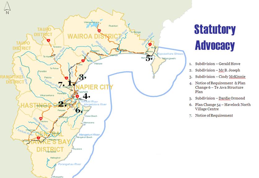
HAWKE’S BAY REGIONAL COUNCIL
Environmental
Management Committee
Wednesday 10 August 2011
SUBJECT: General Business
INTRODUCTION:
This
document has been prepared to assist Councillors note the General Business to
be discussed as determined earlier in Agenda Item 6.
|
Item
|
Topic
|
Councillor
/ Staff
|
|
1.
|
|
|
|
2.
|
|
|
|
3.
|
|
|
|
4.
|
|
|
|
5.
|
|
|
|
6.
|
|
|
|
7.
|
|
|
|
8.
|
|
|
|
9.
|
|
|
|
10.
|
|
|