Meeting of the Hawke's Bay Regional Council Maori
Committee
Date: Tuesday 23 November 2010
Time: 10.15am
|
Venue:
|
Council Chamber
159 Dalton Street
Napier
|
Agenda
Item Subject Page
1. Welcome/Notices/Apologies
2. Conflict of Interest Declarations
3. Short Term Replacement on Committee
Decision Items
4. Action
Items
5. Appointment
of Tangata Whenua Representatives to the Maori Committee
6. Election
of Chairman of the Maori Committee
7. Membership
of Council Committees by Tangata Whenua Nominated Members of the Maori
Committee
Information or Performance Monitoring
8. Verbal
Report on Progress of Cultural Impact Assessment Report 10.30am
9. Update on
Current Issues by Chief Executive
10. Ruataniwha
Groundwater Allocation - Implications for the Consents Process
11. Gravel
Resource Review
12. Ngaruroro
River Flood Protection Scheme Ecological Management and Enhancement Plan
13. Submission
on Marine and Coastal Area (Takutai Moana) Bill
14. Draft
Regional Stormwater Strategy
15. Statutory
Advocacy Update
16. General
Business
HAWKE’S
BAY REGIONAL COUNCIL
Maori
Committee
Tuesday 23 November 2010
SUBJECT: Short Term Replacement on Committee
INTRODUCTION:
Council has
made allowance in the terms of reference of the Committee for short term
replacements to be appointed to the Committee where the usual member/s cannot
stand.
|
RECOMMENDATION:
That ………. be appointed as member/s of the Maori
Committee of the Hawke’s Bay Regional Council for the meeting of Tuesday, 23
November 2010 as short term replacements(s) on the Committee for………………….
|
|

Viv Moule
Human
Resources Manager
|

Andrew Newman
Chief
Executive
|
HAWKE’S BAY REGIONAL COUNCIL
Maori
Committee
Tuesday 23 November 2010
SUBJECT: Action Items
REASON FOR REPORT:
There are no action items to be
considered at this meeting.
|

Viv Moule
Human
Resources Manager
|
|
Attachment/s
There are no
attachments for this report.
HAWKE’S BAY REGIONAL COUNCIL
Maori
Committee
Tuesday 23 November 2010
SUBJECT: Appointment of Tangata Whenua
Representatives to the Maori Committee
REASON FOR REPORT:
1. At the first ordinary meeting of the
Regional Council held on 3 November 2010 the Māori Committee was
re-established as a Committee of Council. The Terms of Reference, Chairman,
membership and frequency of meetings are to be as follows:
2. Terms of Reference:
2.1 To make
recommendations to the Council on matters of relevance affecting the tangata
whenua of the Region, and to help fulfil the Maori consultative requirements
of the Council particularly with regard to the principles of the Treaty of
Waitangi and the Local Government Act 2002.
2.2 To
prepare, within the first six months of the Committee’s establishment, a work
plan for the Committee which will set out in general terms what the Committee
aims to achieve over its three year term.
Members:
· Three elected members
of the Council.
· The Chairman of the Council ex officio.
· Twelve
representatives nominated by the Tangata Whenua who are to be appointed at the
first meeting of the Committee by the three elected members of the Council and
with Tangata Whenua Members of the Maori Committee able to propose to
the Committee short term replacements to attend in their place if they are
unable to attend any meeting with one representative nominated from each of the
following groups:
Kaumatua (Wairoa)
Kahungunu Executive (Wairoa)
Wairoa Taiwhenua (Wairoa)
Kaumatua (Hastings)
Heretaunga Executive (Hastings)
Heretaunga Taiwhenua (Hastings)
Tamatea Executive (Central Hawke’s Bay)
Kaumatua (Central Hawke’s Bay)
Tamatea Taiwhenua (Central Hawke’s Bay)
Kaumatua (Napier)
Te Whanganui a Orotu Taiwhenua (Napier)
Ahuriri Executive (Napier)
· Chairman: A Tangata Whenua member of the Committee as elected by the
Committee.
· Meeting Frequency: Bi-monthly but with the Chairman of the Committee authorised to
arrange additional meetings should the need arise with the fourth Tuesday in
the month being the normal meeting day.
· Staff Executive: Chief Executive
Background
3. At the inaugural meeting Council adopted
the Terms of Reference above and appointed Councillors Liz Remmerswaal, Tim
Gilbertson and Ewan McGregor to the Māori Committee.
4. It is now necessary to formally appoint
the 12 representatives, nominated by the Tangata Whenua, to the Committee.
5. The Committee can also nominate
short-term replacement members who attend committee meetings when any of the
relevant representatives are unavailable.
6. Councillor Ewan McGregor will act as
Chairman of the Committee until Agenda Item 5.
7. The nominations received from Tangata
Whenua are:
Wairoa: Pat Hohipa (Kaumatua),
Fred McRoberts, Adrian Manuel and Miriama Hammond (short term replacement).
Ahuriri: Heitia Hiha (Kaumatua),
Arapera Riki and Jan Aspinall.
Heretaunga: Haami Hilton
(Kaumatua), Peter Paku, and Marei Apatu.
Tamatea: Mike Mohi (Kaumatua),
Morry Black, Liz Graham.
|
RECOMMENDATIONS:
That the
Maori Committee recommends to Council that:
1. Pat Hohipa, Fred McRoberts, and Adrian Manuel representing the
Wairoa area; Heitia Hiha, Arapera Riki, Jan Aspinall representing the Ahuriri
area; Haami Hilton, Peter Paku and Marei Apatu, representing the Heretaunga
area; Mike Mohi, Liz Graham and Morry Black representing the Tamatea area, be
appointed as members of the Māori Committee of the Hawke's Bay Regional
Council.
2. Miriama
Hammond (Wairoa) be nominated as short term replacement member of the
Committee.
(Note: Only
Councillors McGregor, Remmerswaal and Gilbertson are able to vote on this
item.)
|
|
Viv Moule
Human
Resources Manager
|
Andrew Newman
Chief
Executive
|
Attachment/s
There are no
attachments for this report.
HAWKE’S BAY REGIONAL COUNCIL
Maori
Committee
Tuesday 23 November 2010
SUBJECT: Election of Chairman of the Maori
Committee
REASON FOR REPORT:
1. The Chairman of the Maori Committee is
elected by the full Maori Committee and endorsed by the Hawke’s Bay Regional
Council.
2. At a Maori Committee workshop held on 21
September 2010 Mr Mike Mohi was proposed as Chairman of the Maori Committee for
a further three year term. This paper is to now formalise the appointment of
the Chairman for the new term of the Maori Committee.
|
RECOMMENDATIONS:
1. That the Maori
Committee elect Mr Mike Mohi as Chairman of the Maori Committee for a three
year term.
That the Maori Committee recommend to Council that:
1. Following the
confirmation from the Maori Committee, Council confirm Mr Mike Mohi’s
appointment as Chairman of the Maori Committee.
|
|
Viv Moule
Human
Resources Manager
|
Andrew Newman
Chief
Executive
|
Attachment/s
There are no
attachments for this report.
HAWKE’S BAY REGIONAL COUNCIL
Maori
Committee
Tuesday 23 November 2010
SUBJECT: Membership of Council Committees by
Tangata Whenua Nominated Members of the Maori Committee
REASON FOR REPORT:
1. With the
re-establishment of the Māori Committee, the Committee needs to nominate
representatives to sit on various other Committees.
2. These Committees and
Working Parties are: Environmental Management (2), Asset Management &
Biosecurity (2), Hearings , Strategic Planning and Finance Committee (2).
3. Statute does not allow
for the provision of a voting appointment to the Regional Council; however a
representative – usually the Chairman of the Māori Committee- is able to
attend meetings with full speaking rights.
4. The appointee(s) to the
Hearings Committee will be decided at a future time after Council reviews the
membership and Terms of Reference for that Committee. Any Maori member
nominated for Hearing Committee work must undertake accreditation training to
be able to fulfil their role.
5. It should be noted that
Council intends to review the Committee make up before the end of the year so
these appointments should be viewed as an interim measure at this stage.
|
RECOMMENDATIONS:
That the
Maori Committee :
1. Recommend to the Environmental
Management Committee that ……………………..and………………………………. be appointed members of
that Committee.
2. Recommend to the Asset Management and
Biosecurity Committee that …………………………………and……………………………… be appointed members
of that Committee.
3. Recommend to the Strategic Planning and
Finance Committee that the Chairman of the Maori Committee and
………………………………..be appointed members of that Committee.
|
|
Viv Moule
Human
Resources Manager
|
Andrew Newman
Chief
Executive
|
Attachment/s
There are no
attachments for this report.
HAWKE’S BAY REGIONAL COUNCIL
Environmental
Management Committee
Tuesday 23 November 2010
SUBJECT: Ruataniwha Groundwater Allocation -
Implications for the Consents Process
REASON FOR REPORT
1. Council’s Ruataniwha
Basin Transient Model was recently completed and reported to the Environmental
Management Committee meeting on 8 September 2010. The model confirms Council’s
earlier conceptual understanding of the hydrogeology of the Ruataniwha basin
and the actual effects of groundwater abstraction upon overlying surface
water. The purpose of this paper is to present the Committee with information
derived from initial modelling, and inform the Committee that the existing
resource consent application management approach should be continued.
Background
2. In 2007, two papers
were presented to the Council which summarised the then current state of
knowledge of the interactions between groundwater in the Ruataniwha basin with
surface water flowing across the basin area (the Tukituki and Waipawa rivers
and their tributaries).
3. The 2007 papers noted
that:
3.1 Abstraction of
groundwater from the Ruataniwha basin resulted in a 13% reduction in summer
flows in each of the Tukituki and Waipawa rivers based on the ‘Gyopari’
groundwater flow model. Also the combined reduction in flow in these rivers
was estimated at 900 L/s.
3.2 Increased abstraction
of groundwater would result in an increased reduction in stream flows.
3.3 Staff recommended
that applications for consent to take groundwater from the Ruataniwha basin be
publicly notified, with a likelihood of the staff recommendation being to
decline the application.
3.4 Council endorsed the
resource consent application management approach proposed.
4. Groundwater and surface
water in the Ruataniwha basin area are inextricably linked, and therefore
groundwater allocation cannot be considered in isolation of surface water
allocation limits. In a planning context, Council is guided by the Regional
Resource Management Plan (RRMP) water allocation policies and objectives
relating to both groundwater and surface water resources.
5. The RRMP does not
quantify groundwater allocation limits for the Ruataniwha basin. However, the
RRMP does contain some relevant objectives and policies including:
5.1 Objective 23 - the
avoidance of any significant adverse effects of water takes on the long-term
quantity of groundwater in aquifers and on surface waters
5.2 Objective 44 - the
maintenance of a sustainable groundwater resource
5.3 Policy 77 - (a) to
manage groundwater takes so that the abstraction does not exceed the rate of
recharge, and (d) to manage takes of groundwater to ensure that abstraction
does not have an adverse effect on rivers, lakes springs and wetlands.
6. The RRMP also provides
allocation limits for specified Stream Management Zones (SMZ) (Policy 74, Table
9), including those within the Tukituki River and its tributaries. These
stream management zones are fully allocated.
7. Since 2007, no new
consents have been issued to authorise the taking of additional water from the
basin. The management approach established by the 2007 Council papers has been
adhered to.
8. There are currently 80
consents authorising the abstraction of approximately 450,000 m3
per week of groundwater from the basin. A significant group of current
consents will expire in 2015 (36), at which time the cumulative effects of
these takes can be considered.
9. Existing groundwater
consents authorise the irrigation of approximately 7,000 hectares of land,
predominantly for pasture and cropping.
Scientific Context and Update
10. In 2003 Council
commissioned Phreatos Consultants to upgrade an earlier attempt at modelling
the Ruataniwha basin in order to better represent the surface and groundwater
interaction in the basin and to enable more robust predictions to be made. This
work produced a new model (the Gyopari Model) in 2004 which was constructed in
Modflow software and consisted of two layers to better represent the
hydrogeology of the basin.
11. The results of the
Gyopari Model concluded that existing groundwater takes were connected to and
depleting surface water. The results of the model indicated a flow reduction in
the order of 500 L/s from the Tukituki River, and 400 L/s from the Waipawa
River (total 900 L/s) and a loss of groundwater storage.
12. The Gyopari Model tried
to overcome the limitations of the previous model by calibrating the water
balance. Some changes to the input parameters were made but the model was still
limited in its consideration of surface water/groundwater interactions, as the
river data that was used was empirical and not based on actual field data. In
summary, the two previous groundwater flow models were unreliable because of a
lack of data to calibrate the model and inadequate water balance analysis to
quantify basin recharge.
13. In 2007 Council
commenced development of further modelling to address the deficiencies of the
previous models and establish a more scientifically defensible position to
support the Council’s development of water management policies for the basin.
14. A water balance model
for Ruataniwha was completed in 2008 (Baalousha 2008) and used groundwater
abstraction data (based on compliance monitoring) and crop water requirement.
This model quantified groundwater abstraction as having
increased from 3 million cubic metres in 1990 to approximately 24 million cubic
metres in 2009 (Figure 1). This model was used as a
basis for development of a steady-state groundwater flow model.
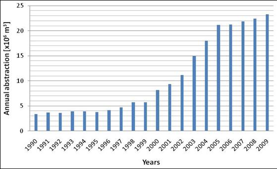
Figure 1: Annual Groundwater Abstraction Trends in
Ruataniwha Basin
15. A steady-state
groundwater flow model was completed in 2009 (Baalousha 2009) and was used as
the basis for the transient groundwater flow model. The model was peer reviewed
by independent experts. The next stage was the development of the transient
model, which has recently been completed and peer reviewed.
16. The new transient model
confirms that there is a strong interconnection between the groundwater and the
surface water in the basin. Model results also showed that the actual
groundwater abstraction across the basin over the last 20 years has caused a
decline in aquifer storage of approximately 66 million m3. This will
result in a continued decline of aquifer water levels and more importantly
stream and river flows within the basin until a new dynamic aquifer equilibrium
is reached depending on the uptake and use of existing allocated volumes and
any further allocation decisions. This will not only impact existing surface
water consent holders, but also the ecological, cultural and other values
associated with the rivers and streams in the basin and downstream beyond the
basin.
17. The transient model has
also confirmed that there has been a significant decline in spring flow and
that the cumulative effect of current actual groundwater abstraction has
resulted in a decline rate of 600 L/s from surface waters in the basin
area. This decline is less than that predicted in the 2004 Gyopari Model (900
L/s). However the new model provides a greater degree of confidence considering
it is significantly more sophisticated and supported by more robust data
compared to the earlier Gyopari model, which relied on some conservative
assumptions in the absence of data.
18. The transient model will
be used to model different scenarios of groundwater use in the basin, to enable
an assessment of the cumulative impacts of water use. These
scenarios include full uptake of existing consented allocation, intensification
of land use to 14,000 hectares, and scenarios that reflect the Proposed
National Environmental Standard on Ecological Flows and Water Levels (March
2008) (35% of rainfall recharge). This information
will then be used to support water allocation policy development for the basin.
19. A groundwater age
isotope and tracing study has recently been completed for the basin which
supports model calibration and conceptual understanding of complex and
interconnected groundwater system.
Allocation and Demand
20. Demand for groundwater
in this area continues. Three further applications have been lodged and are
currently being processed following the approach established by the 2007 paper.
These applications seek a total of 120 L/s and 62,556 m3/week.
21. The modelling work
undertaken using the Transient Model confirms, and more accurately quantifies
the earlier understanding of the link between groundwater and surface water in
the Ruataniwha basin area.
22. Given the evidence
provided by the Transient Model which indicates declining spring and stream
flows as a result of current groundwater abstraction in the basin, staff will
continue to recommend that the previously established allocation management
approach be followed. Applications for consent to abstract groundwater from
the basin will generally be publicly notified, and the staff recommendation is
likely to be to decline such applications. This approach will continue to be
followed as an interim measure until a plan change process has been completed,
at which time it is envisioned that a revised plan will offer an allocation
framework for the Ruataniwha basin aquifer and its associated surface waters.
23. Applications can still
be made and staff are required to process any such applications as a moratorium
is not legally available under the RMA. However an assessment of environmental
effects (AEE) would be required to investigate the contribution of the proposed
take on cumulative adverse effects, and ways to mitigate these effects. This
assessment would be required in addition to an assessment of the localised effects
of a proposed take, such as well interference and direct stream depletion
through hydraulic connection with nearby surface waters.
24. Applicants who wish to
abstract groundwater are advised to consider alterative options, including
sharing of existing consented allocations, transferring permits between parties
and increasing irrigation efficiency and water storage. A degree of sharing
and transferring of consented allocations is already occurring in this area.
Staff will also advise applicants that the Central Hawke’s Bay Water Storage
Project may provide access to water for some parties in the intermediate to
long term.
25. Communication of
Council’s current position on groundwater allocation within the Ruataniwha
basin will occur with key stakeholders in the Ruataniwha community via
workshops and meetings with water user groups and other interested parties.
Officers are also currently working on a communication strategy using
traditional media such as newspaper articles, radio messaging and brochures,
but also using industry group publications, internet forums, and rural interest
group media to deliver some of the key messaging outlined in this paper.
|
RECOMMENDATION
1. That the Committee receives the
report titled ‘Ruataniwha Groundwater Allocation – Implications for the
Consents Process’.
|
|

Paul Barrett
Consents
Officer
|

Dave Moule
Manager
Consents
|
|

Husam Baalousha
Senior
Groundwater Scientist
|

Dougall Gordon
Principal
Groundwater Scientist
|
|

Graham Sevicke-Jones
Manager
Enviromental Science
|

Darryl Lew
Group
Manager
Resource
Management
|
Attachment/s
There are no
attachments for this report.
HAWKE’S BAY REGIONAL COUNCIL
Maori
Committee
Tuesday 23 November 2010
SUBJECT: Gravel Resource Review
REASON FOR REPORT:
1. This report is to
update the Asset Management Biosecurity Committee on progress with the Review
of Riverbed Gravel Management. This is part of the Gravel Management Project
(Project 369).
Background
2. The Hawke’s
Bay river borne gravel resource is increasingly under pressure particularly in
the proximity of the Heretaunga Plains. Gravel extraction forms an integral
part of ongoing flood protection to both Heretaunga and Ruataniwha Plains, with
gravel being extracted such that the flood capacity of the schemes is
maintained, and the potential for the rivers to undermine edge protection is
minimised. The majority of the easily accessible rivers are now effectively
managed through this process, but gravel stocks are limited in these areas
meaning there is pressure on gravel extractors to win their resource greater
distances from their markets putting pressure on their competitiveness.
3. In addition
there is increasing concern being expressed by the public that river gravel
extraction is aggravating coastal erosion, particularly in Haumoana and Te
Awanga.
4. The Asset
Management section believes it is imperative for Council to have an effective
framework for the ongoing management of the gravel resource within the region,
supported by robust science and processes.
5. A scoping
report to identify the issues associated with the current management of the
region’s river bed gravel resource has therefore been commissioned which once
implemented will:
5.1 Improve
Council’s understanding of riverbed gravel movement and the impact of gravel
extraction on flood protection works and coastal processes.
5.2 Enable
Council to review its management regime for assessing the gravel resource and
for managing its extraction.
5.3 Inform
co-management discussions with regard to the gravel resource and its management
with Treaty Claimant Groups.
6. Tonkin and
Taylor was commissioned to assist in the review and provide a scoping report
together with a prioritized programme of work that could be accommodated in a 6
year time span. A draft scoping report has now been completed and will be
outlined by staff.
7. In order to
carry out the review and obtain a wide view of community concerns and ideas on
the gravel resource a number of meetings were arranged to discuss the issues. A
separate meeting was held with the key people in the gravel supply industry to
hear their views as they have a different perspective on the resource than
other interested parties. A meeting was held with DOC, Fish & Game and the
TLA’s. A hui was widely advertised and held at Kohupatiki Marae to inform and
discuss with hapu associated with the rivers the issues relating to gravel
management. In addition a number of specialists working in the fields of
coastal and river gravel processes were interviewed for their expert knowledge.
8. HBRC has a
number of responsibilities that have a direct bearing on the management of
gravel resources in the region:
8.1 It has the
jurisdiction to manage and authorise activities in riverbeds
8.2 It has the
jurisdiction to manage and authorise activities in the coastal area
8.3 It has
responsibility for flood control and protection of assets.
9. There is an
ongoing demand for gravel and aggregate for a range of activities in the
roading and construction industry. There is a need to balance the allocation of
gravel between supply demand and the need to maintain the flood capacity of
flood protection schemes. This balance should also take account of the
environmental effects of gravel extraction, Māori views and the river
ecology.
10. Extensive
flood protection schemes have been established throughout the Heretaunga Plains
and the Ruataniwha Plains, managed by HBRC. These schemes are designed and
constructed to a standard (1% Annual Exceedance Probability, AEP) and this standard must be maintained through maintenance of the channel carrying capacity
and design riverbed levels.
11. The main
population areas and therefore gravel demand are on the Heretaunga Plains.
However the gravel resources are spread between the Northern area (125,000m3
per annum), Heretaunga (440,000 m3) and Ruataniwha (370,000 m3).
There is a tension between the gravel supply and the gravel demand areas due to
the extra transport costs. This has implications for HBRC’s management of the
flood protection schemes as too high a cost to extract the gravel may result in
gravel extractors preferring to establish land based sources. HBRC currently
has little ability to manage these land based areas.
12. There is
uncertainty over the potential effects of riverbed gravel extraction, specifically
in relation to the following aspects:
12.1 Long-term
riverbed morphology
12.2 Long-term
riverbed gravel supply
12.3 Sediment
supply to the coast and the effect on coastal stability
12.4 Riverbed
ecology and biodiversity
12.5 Sites and
issues of significance to tangata whenua
13. The review
was tasked with addressing these affects and determining what further work, if
any is needed to provide HBRC and other interested parties with the information
necessary to manage the gravel resource as well as confirming or otherwise
whether the current management regime and processes are appropriate for long
term sustainability.
14. The review
highlighted 13 separate but related issues that require further investigation.
A staff presentation will highlight and explain some of these. The order
presented in the table below begins with the highest priority first and some of
the later issues are dependent on the earlier studies. Rough order costs to
carry out the work have been assigned to each issue. In addition there are
annual costs associated with Tangata Whenua involvement and a steering group.
|
|
Issue
|
Total Indicative cost
|
Stage
|
|
1
|
Hydrological
Review
|
$40,000
|
Stage 1
|
|
2
|
Gravel Supply
& Transport
|
$110,000
|
|
3
|
Gravel Resource
Inventory
|
$60,000
|
|
4
|
Implications for
Flood Protection
|
$40,000
|
|
5
|
Gravel Demand
& Forecast
|
$30,000
|
|
6
|
Gravel
Monitoring & Resource Availability
|
$40,000
|
|
7
|
In-stream
Ecological Effects
|
$75,000
|
Stage 2
|
|
8
|
Riverbed Birds
& Flora
|
$45,000
|
|
9
|
Tangata Whenua
Values
|
$20,000
|
|
10
|
Effectiveness of
Beach-raking
|
$40,000
|
Stage 2
|
|
|
Issue
|
Total Indicative cost
|
Stage
|
|
11
|
RMA Issues
|
$30,000
|
Stage 3 (RMA issues sooner)
|
|
12
|
Allocation &
Financial Mechanisms
|
$30,000
|
|
13
|
Riverbed Gravel
Management Plan
|
$75,000
|
Final Stage
|
|
|
Total
|
$635,000
|
|
|
|
Tangata Whenua
consultation
|
$10,000/year
|
|
|
|
Steering Group
|
$10,000/year
|
|
|
|
|
|
|
15. The terms of reference for the review were to consider the costs
spread over a number of years at about $100,000 per year. This of course is
subject to a suitable source of funding and could be expanded or reduced to
suit. At present 6 years is the time period considered.
16. Staff believe that there are three possible options for funding the
work
16.1 Council to meet the costs of the work, possibly through the flood
control and drainage schemes.
16.2 Increase Resource Management charges currently levied on a per cubic
metre rate on all river bed gravel extracted. With the current level of
extraction averaging approximately 600,000 cubic metres per annum this would
require an increase of the levy currently charged from $0.60/m3 to
approximately $0.80/m3.
16.3 A combination of the above.
17. Staff propose to discuss these options with gravel extractors over
the next several months so that a firm funding proposal is able to be included
in Council’s draft 2011/12 Annual Plan for formal comment. Subject to Council
agreement to include this work in the final 2011/12 Annual Plan, staff expect
to commence the project work in the 2011/12 financial year.
|
RECOMMENDATION:
1. That the Maori
Committee confirms their support for the River Bed
Gravel Review project.
|
|

Mike Adye
Group
Manager Asset Management
|

Gary Clode
Manager
Engineering
|
Attachment/s
There are no
attachments for this report.
HAWKE’S BAY REGIONAL COUNCIL
Maori
Committee
Tuesday 23 November 2010
SUBJECT: Ngaruroro River Flood Protection
Scheme Ecological Management and Enhancement Plan
REASON FOR REPORT:
1. This report is to
update the Asset Management Biosecurity Committee on progress with the river management
review entitled “Ngaruroro River Flood Protection and Drainage Scheme:
Ecological Management and Enhancement Plan”. (Referred to as EMEP). This is
part of the Annual Plan work for Project 287, HPFCS Flood and River Control.
Background
2. River corridors within
Council’s major flood protection schemes are highly modified from their
original meandering pathways across their flood plains. Today’s society has
adapted to harnessing the productive capacity of the flood plains soils, and
relies heavily on a minimal risk of disruption from flooding or the rivers
changing course.
3. Consequently the focus
of the management of the Flood Protection Schemes over the past 100 years has
been the protection of the plains land from frequent flooding. In today’s
environment it is appropriate that as river managers, a wider view is taken,
including opportunities that the river systems, and associated berm land
provide for increased biodiversity, environmental enhancement and public
enjoyment, while maintaining the integrity of the flood protection assets.
4. Accordingly the Asset
Management section is reviewing the way in which Council manages the river
corridor and riparian margins of the major river systems in the Hawke’s Bay
region.
5. The review includes
Maori tikanga and kaitiaki with respect to river management across the wider
region. Intricately linked with Maori tikanga is the ecology of the river
(terrestrial and aquatic). The effects of current river management on the
ecology of the rivers are not well understood and this review examines ways in
which the ecology can be maintained and enhanced.
6. To address some of the
issues concerning Maori, ecological issues and general day to day management of
the schemes, Council in December 1999 adopted the “Environmental Code of
Practice for River Control and Drainage Works” (The Code of Practice). This
Code of Practice was developed in consultation with Iwi, Department of
Conservation, Fish and Game NZ, staff of HBRC and other interested parties.
This Code of Practice was updated in 2003 and is due for update again. The
updated version will incorporate findings of the Ecological Management and
Enhancement Plan (EMEP).
7. The activities
described in the Code of Practice relate solely to river control (and drainage
works). The code does not refer to any of the wider environmental activities
that the Regional Council carry out that can have an impact within the
catchments of the region. One of the key differences of this river management
review and resulting EMEP is that the extent of the review extends beyond the
scheme boundary to the base of the ranges. This is because what is happening
further up the catchment has an effect in the lower reaches.
8. Within the actual
scheme area, management on a day to day basis is carried out in accordance with
the Code of Practice. Specifically the Code deals with environmental outcomes,
public access, river works that are covered by the permitted activity rule
within the Regional Resource Management Plan, and standard operating procedures.
The EMEP provides greater detail on environmental outcomes and opportunity for
Maori tikanga. Specifically, the EMEP provides guidance on how river works
should be carried out to sustainably manage the ecology.
9. Consultants MWH Ltd were engaged to assist with the river management review and other specialist advice was
sought throughout the review process. The review is in two parts.
9.1 Chapters 1 to 3 focus on
the physical activities and associated ecological effects of the Ngaruroro
River Flood Control Scheme. Where conflict between the Scheme and notable
ecological values may occur, a range of specific management controls are
recommended. This is detailed in chapter 3 and covers the vision, goals, issues
and objectives. The methods to achieve the objectives are explained.
9.2 Chapter 4 sets out a
strategy and prioritised plan for the enhancement of existing ecological
values and for the creation of new ecological sites. (Note that the enhancement
plan section of the review was not able to be completed for this Council
Meeting, but is due mid December 2010).
10. The enhancement
section of the EMEP has a particular focus on providing habitat for threatened
species and promoting a functional value of the Scheme as a wildlife corridor,
facilitating movement of plants and animals between the more intact upper
reaches, downstream to the coast and urban areas on the Heretaunga Plains.
11. This EMEP plays an
important part of increasing biodiversity in the region. The NZ Government has
implemented the NZ Biodiversity Strategy (NZBS), of which “Goal Three”
seeks to “halt the decline in New Zealand’s indigenous biodiversity”.
The EMEP is a key method for HBRC to use in addressing the intent of Goal Three
of the NZ Biodiversity Strategy for the scheme area.
12. The EMEP includes the
findings of literature review, field survey of flora, sampling and studies of
river birds, terrestrial invertebrates, freshwater fish and lizard communities.
13. Maori cultural values of
the river were assessed by way of oral history with hapu representatives
associated with the river.
14. Recreational use (type,
location and intensity) was investigated through site visits, knowledge of the
river and available public information.
15. Staff will outline
significant findings of the review and plan in a presentation.
16. Scheme funding
implications:
16.1 The EMEP is a guidance
document on how to carry out river works for sustainable management of the
ecology and thereby provide a sound basis for Maori cultural values to thrive,
alongside the recreational values associated with the river. The management
vision and goals are reflected in the management plan. The proposed management
regime is about doing things differently, with specific targets or goals to
achieve. In many instances there are no significant cost implications in
carrying them out.
16.2 The most significant area
where there are additional cost implications is in management of the braided
gravel riverbed upstream of the scheme boundary and management of native vegetation.
|
RECOMMENDATION:
1. That the Maori Committee accepts the
findings review and endorses the Ngaruroro Ecological and Enhancement Plan
(EMEP) for use in future river management.
|
|
Mike Adye
Group
Manager Asset Management
|
|
Attachment/s
There are no
attachments for this report.
HAWKE’S BAY REGIONAL COUNCIL
Maori
Committee
Tuesday 23 November 2010
SUBJECT: Submission on Marine and Coastal Area (Takutai Moana) Bill
REASON FOR REPORT:
1. The Government has
released the Marine and Coastal Area (Takutai Moana) Bill and invited
submissions. The Bill follows an independent review of the Foreshore and
Seabed Act 2004 (‘FSA’) which was part of the National Party and Maori Party
coalition government agreement.
2. A similar paper and
draft submission was considered at the Environmental Management Committee
meeting on 10 November 2010. The Environmental Management Committee agreed to
seek additional input on the draft submission from the Maori Committee. This
paper presents an overview of the Bill’s key features as described in the media
release by Minister Christopher Finlayson.
Background
3. In 2009, an independent
Ministerial review panel concluded that:
3.1 the FSA was
discriminatory and unfair; and
3.2 failed to balance the
interests of all New Zealanders in the foreshore and seabed.
4. Now, the Bill:
4.1 Repeals the Foreshore
and Seabed Act 2004.
4.2 Applies to the area
formerly known as the foreshore and seabed, which will be known in future as
the ‘marine and coastal area.’ This extends from mean high water springs to the
12 nautical mile limit (approx 22km offshore).
4.3 Creates a common space
in the marine and coastal area (the ‘common marine and coastal area’) which
allows the interests and rights of all New Zealanders in the marine and coastal
area to be recognised in law.
4.4 Proposes common marine
and coastal area as incapable of being owned (as opposed to FSA which vested
ownership in Crown).
4.5 Guarantees free public
access in the common marine and coastal area.
4.6 Does not affect private
titles in the marine and coastal area.
4.7 Guarantees and, in some
cases, extends existing rights for navigation, ports, fishing and aquaculture.
4.8 Provides for the
customary interests and rights of Maori in the common marine and coastal area
to be recognised in three ways:
4.8.1 Customary marine
title - the right to go to the High Court (or
negotiate an out-of-court settlement with the Crown) to seek customary marine
title for areas with which groups such as iwi and hapu have a longstanding and exclusive
history of use and occupation. Customary marine title will:
· be
subject to the right of public access and cannot be sold;
· give
rights to permit activities requiring a resource consent (known as a ‘RMA
permission right’), some conservation activities, protection of wahi tapu,
ownership of taonga tuturu found in that space, and ownership of non-Crown
minerals (i.e. not petroleum, gold, silver, and uranium).
· give
title holder the right to create a planning document setting out objectives and
policies for the area. Councils must recognise and provide for the planning
document in their regional plans and regional policy statements.
4.8.2 Protected customary
right - groups such as iwi and hapu will also be
able to gain recognition and protection for longstanding customary rights that
continue to be exercised.
4.8.3 Mana tuku iho – iwi and hapu groups will also be recognised through a status known
as mana tuku iho, which formalises existing best practice in coastal
management. This will allow them to take part in conservation processes in the
common marine and coastal area (e.g. establishment of marine reserves and
conservation areas, and the management of stranded marine mammals).
4.9 retains current
ownership of roads and structures in common marine and coastal area. Abandoned
structures shall pass to the Crown.
4.10 preserves any leases,
permits, resources consents, licences etc granted before Bill becomes an Act.
4.11 does not affect the
regulation of activities within the common marine and coastal area under other
legislation. In particular, there is no change to the granting of resource
consents, except that an ‘RMA permission right’ may apply to an area within a
customary marine title area.
4.12 ‘RMA permission rights’
do not apply to existing structures or infrastructure that is nationally
or regionally significant. This exception may also apply to new
structures or infrastructure deemed nationally or regionally significant by the
Minister of Land Information.
5. The Bill has been
referred to the Maori Affairs Select Committee. Closing date for submissions
was 19 November 2010.
Council Submission
6. There are strong
similarities between the Bill’s proposals and the regime that applies under the
existing FSA. There are some obvious differences, the most notable being no
ownership of the marine and coastal area as opposed to the Crown ownership of
the foreshore and seabed.
7. Senior council staff
have reviewed the Bill’s explanatory papers and participated in technical
workshops with government officials and facilitated by Local Government New
Zealand (LGNZ). The Bill itself is an extremely complicated piece of
legislation.
8. LGNZ has led the way
for assessing implications of the Bill for local government, particularly
regional authorities. LGNZ have lodged a detailed submission on the Bill.
9. Given the complexity of
the Bill itself and LGNZ’s very detailed submission, staff recommended that
Council still make a submission on the Bill. At the time of writing this
paper, a draft submission was to be considered at an Extraordinary Council
meeting on 18 November. A copy of that draft submission is set out in
Attachment 1. The draft submission does not tackle the detail (but LGNZ’s
submission does). The draft submission focuses on presenting a ‘Hawke's Bay
flavour’ of the Bill’s implications.
Submission Lodgement
10. The deadline for
submissions on the Bill was Friday 19 November. The diagram below illustrates
how the Maori Committee’s input could feature after this deadline.
Figure
1: Maori Committee input into Council submission after deadline
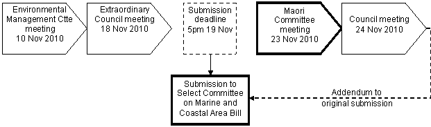
11. A request has already
been made to the Maori Affairs Select Committee clerk for permission to lodge
an addendum (if necessary) to submission lodged before the 19 November
deadline.
|
RECOMMENDATIONS:
That the
Maori Committee :
1. Considers the draft submission on the Marine and Coastal
Area (Takutai Moana) Bill set out in Attachment 1; and
2. Recommends to Council any amendments that should be made as
an addendum to the Council’s submission originally lodged before the 19
November submission deadline.
|
|

Gavin Ide
Team Leader Policy
|

Liz Lambert
Group
Manager External Relations
|
Attachment/s
|
1View
|
20101118 HBRC
Draft Submission on the Marine and Coastal Area (Takutai Moana) Bill
|
|
|
|
20101118 HBRC Draft Submission on the
Marine and Coastal Area (Takutai Moana) Bill
|
Attachment 1
|
|
November 2010
|
Our Ref :4/42/1
|
Clerk
of the Committee
Maori
Affairs Select Committee
Parliament
Buildings
WELLINGTON
via online submission at www.parliament .govt.nz
Marine and Coastal Area (Takutai Moana)
Bill
SUBMITTER: HAWKE’S BAY REGIONAL COUNCIL
1. Introduction
1.1. The
following submission by the Hawke’s Bay Regional Council has been prepared in
response to the Marine and Coastal Area (Takutai Moana) Bill. Councillors
formally considered the submission at a special meeting held on 18 November 2010
and agreed to seek further input from its advisory Maori Committee. We
respectfully request permission to submit an addendum to this submission
following the inaugural meeting of the Maori Committee (on 23 November) and
subsequent Council meeting on 24 November.
1.2. The
Hawke’s Bay Regional Council is a member of Local Government New Zealand and
supports the submission lodged by Local Government New Zealand. We acknowledge
LGNZ’s submission is thorough and addresses many details in virtually a clause
by clause analysis. Our submission does not intend repeating that detail.
1.3. This
submission should be read as an endorsement and extension of LGNZ’s detailed
submission. The Council’s submission sets out more general comments providing
a local ‘flavour’ to the Bill’s implications for Hawke's Bay.
2. general statement
2.1. The
Council supports the intent of the Bill in seeking to ensure public access to
the coastal marine area and the preservation of navigation rights for all. We
also support the Bill’s proposal providing clarity and certainty around
preservation of existing reclamations, permits, consents etc, and the
associated ownership of structures and infrastructure.
2.2. The
Council also offers qualified support to the provisions of the Bill which seek
to provide recognition for customary rights of Maori in the use of coastal
resources.
2.3. However,
we do not support the establishment of those rights for Maori to undertake
activities outside of the environmental management frameworks established under
the RMA.
3. Council
and IWi/Hapu Relationships
3.1. The
Council works collaboratively with a wide range of interest groups, stakeholder
and kaitiaki for the maintenance and enhancement of coastal resources. The
Council actively engages with iwi/hapu in undertaking its extensive range of
activities and projects.
3.2. There
are nine Treaty Claimant Groups with interests in Hawke's Bay. The Council is
currently in discussions with each of those groups about the form and function
of a ‘joint plan committee.’ This committee would oversee the review and
development of the regional policy statement and regional plans for Hawke’s Bay
including any plans for the coastal marine area.
3.3. The
co-governance of natural resources as proposed in Hawke’s Bay has the potential
to circumvent the need for the recognition and provision for a plethora of
planning documents that could apply along the Hawke’s Bay coastline.
4. Protected
Customary rights
4.1. The
Council does not support the Bill’s proposal for ‘protected customary rights.’
The Council supports acknowledgement of long-standing customary use of
resources along parts of the region’s coast, but we do not support the proposal
for such rights to be virtually immune from the current RMA framework.
4.2. The
Council has prepared a second generation regional coastal plan (combined with
regional plan provisions for the wider coastal environment). That ‘Regional
Coastal Environment Plan’ (RCEP) has been through an open consultative process
with the Maori Committee, coastal hapu representatives, and the wider Hawke's
Bay community to determine an appropriate regime for the management of the
region’s natural and physical coastal resources. The RCEP manages the effects
of activities in accordance with the principles of the RMA and in doing so,
gives effect to the 1994 NZ Coastal Policy Statement.[1] The Council
does not support the Bill’s proposal for protected customary rights to be
allowed irrespective of degree of their environmental impact.
4.3. While
the Bill does provide for monitoring and intervention by the Minister in
protected customary rights if there are significant adverse effects, the
Council considers those provisions to be inappropriately reactive rather than
proactive sound resource management practice. The environment could suffer
irreversible damage prior to necessary conditions being put in place under the
Bill’s proposals.
4.4. The
Council also opposes the Bill’s proposal for ‘protected customary rights’ in
relation to abilities for protected customary rights:
a) to
potentially be undertaken in a contemporary setting (ie: not restricted to
historic and traditional methods, but potentially undertaken using 21st century
techniques and technologies); and
b) to be
undertaken for commercial purposes; and
c) to be
transferred to third parties.
4.5. Full
exercise of the above rights could have perverse and undesirable outcomes for
the location, scale and type of activities undertaken in Hawke's Bay’s coastal
area. For the avoidance of doubt, the Council is not opposed to Maori
undertaking customary activities for commercial purposes, but transferral of
rights to third parties is alarming.
4.6. The
Council considers that the same resource management regime should apply to all
activities regardless of what proprietary rights exist to establish the
activity.
4.7. In
Hawke's Bay, the Council is not aware of any evidence to suggest any customary
activities have faced undue problems or interference arising from the RMA and
regional coastal plans since 1991.
5. Planning documents
5.1. The Council
does not support the Bill’s proposal for incorporation of ‘planning documents,’
prepared by customary marine title holders, into regional planning documents.
By virtue of the requirement to “recognise and provide for” such planning
documents, the Bill elevates these planning documents to the same status as
matters of national importance (under s6, RMA). This may occur without the
open consultative engagement expected of councils when preparing regional
policy statements, regional plans or district plans. Planning documents can
cover a wide array of matters, but of most concern to us is the manner in which
they can be prepared (ie: without any public or council input) followed by the
consequential inclusion of the document into the RPS and/or regional plans.
5.2. It is the
Council’s opinion that the Bill’s proposals regarding preparation of planning
documents and their subsequent incorporation into regional planning documents
shows little consideration for integrated resource management and existing
statutory processes under the RMA. This results in the Bill elevating planning
documents to an unjust and untenable status all without consultation or
reference to existing statutory frameworks.
5.3. We suggest
that planning documents prepared by customary marine title holders should be
accommodated within the existing RMA framework and not elevated to a matter of
national importance without a fuller open consultative process for their
preparation.
6. Infrastructure
6.1. The Bill
will have implications for the Council’s asset management role and
infrastructure, particularly flood control works in river mouths and estuarine
locations of the coastal marine area. While the Bill provides for existing
‘nationally or regionally significant’ infrastructure (ie: within the meaning
of ‘accommodated activity’ in Clause 8(2)), we consider the Bill misses an
opportunity to properly provide for new nationally or regionally significant
infrastructure.
6.2. By way of
example, Council sometimes erects hard defences along margins of river channels
to prevent damage to stop banks. A type of reinforced concrete armouring has
been constructed at Haumoana on Tukituki River to protect stop banks and
prevent major flood risk to the community. Tukituki River design capacity at
4800cumecs. Severe and extensive flooding would occur if the stop banks
failed. This armouring sits within bed of river and is within the Marine and
Coastal Area. Regardless of ownership, RMA permissions could restrict or
prohibit further flood protection works, despite their significance to the
regional and national productivity.
6.3. We
recommend that the meaning of ‘accommodated activities’ be amended to include
all ‘nationally or regionally significant’ infrastructure – regardless of
whether it is existing, upgraded or new.
6.4. The Council
is now a 100% shareholder in Port of Napier Limited – the port company for Port
of Napier. It is imperative long-term investment decisions made by the Port
company reflect infrastructural nature of assets being developed. Port of
Napier is totally dependent on reclaimed land for current and future land
requirements. We accept that the Bill attempts to consolidate existing
property rights approval procedures for reclamations (as distinct from resource
consenting processes). Economic development of Hawke’s Bay and other regions
like it could be severely curtailed if ports cannot secure title and tenure for
future reclamations and wharf developments.
6.5. Compared to
the Foreshore and Seabed Act’s provisions for reclamations, we support the
Bill’s proposals for developers of reclaimed land to have ‘first option’ on
applying for property rights. Without this improved certainty of occupancy and
ownership, ports may not reclaim foreshore and seabed.
7. Ministerial Discretion and Regional Council Functions under RMA
7.1. The Council
is concerned with the extent of proposed Ministerial RMA discretions under the
Bill. These discretions are not required to draw on any policy contained
within any regional planning documents prepared under the RMA. This is not
acceptable given the complex processes and commitment of resources to develop
plans in the first place. The discretions must to take into account policy and
regulatory frameworks already developed under the RMA (eg: NZCPS, RPS, RCP,
etc). These planning documents have all involved extensive public consultation
often in combination with detailed scientific research and information.
7.2. We
reiterate that many of the Ministerial discretionary RMA powers are reactive to
environmental impact rather than proactive sound resource management practice.
7.3. Council
notes that the Bill (in Schedule 3) proposes replacing s30(1)(d)(ii) of the
RMA. The effect of the substitution as proposed would be significant on the
respective roles and responsibility of regional councils and the Minister of
Conservation. However, government officials have recently indicated that the
replacement clause contains a drafting error (the word “not” unintentionally
appears). We assume officials will bring this error to the Select Committee’s
attention for it to be remedied.
7.4. We would
support the error being corrected. In effect, the correction would revert
roles and responsibility for controlling occupation of the common marine and
coastal area to regional councils. Similarly, the correction would maintain
the status quo with regional councils having responsibility for control of
extraction of sand, gravel, shell, etc in the common marine and coastal area.
8. Hearing of submission
8.1. Council
wishes to appear at the Select Committee meeting on this Bill to be heard on
this submission.
Yours
faithfully
Fenton Wilson
CHAIRMAN
Address for service: Hawke's Bay Regional
Council
Private Bag 6006
NAPIER 4142
Attn: Gavin Ide
p: (06) 833-8077
f: (06) 835-3601
e: gavin@hbrc.govt.nz
HAWKE’S BAY REGIONAL COUNCIL
Maori
Committee
Tuesday 23 November 2010
SUBJECT: Draft Regional Stormwater Strategy
REASON FOR REPORT:
1. Council’s work plan identifies the need
to review stormwater discharge management under the Resource Management Act
1991 (RMA). This paper outlines the contents of a Draft Regional Stormwater
Strategy based upon the meetings of the Regional Stormwater Working Group.
Background
2. At its meeting on 22 July 2009 Council
decided not to proceed with the notification of the provisions of Regional
Resource Management Plan (RRMP) Change 3 and Proposed Regional Coastal
Environment Plan (PRCEP) Variation 3. At that time Council endorsed the
establishment of a Regional Council/Territorial Local Authority Collaborative
Stormwater Working Group of staff, for the purpose of developing an agreed
approach to stormwater management in the Region. As the Territorial Local Authorities
are the managers of stormwater planning and infrastructure it was considered
important to gain agreement on the common principles of stormwater management
before notification.
3. The membership of the Working Group
included staff representatives from each of the TLAs and HBRC, as well as a
cultural representative nominated by the Chair of this Council’s Maori
Committee. Other stakeholders invited to participate were Fish and Game New
Zealand and the Department of Conservation.
4. The Working Group has met three times
since its establishment and has now reached a stage where a Draft Regional
Stormwater Strategy (Attachment 1) is ready for further input from the Maori
Committee. The draft Strategy before the Committee has not yet been finalised
by the Working Group. The Working Group will ultimately report to a joint
workshop of Councils when the draft Strategy is finalised.
5. The Strategy will provide a
non-statutory framework from which to address a range of water quality and
quantity and environmental issues in a coordinated, integrated and prioritised
manner.
Issues and Objectives
6. The Strategy identifies stormwater
discharges as having a number of adverse effects on receiving environments.
The effects of stormwater discharges can be classified broadly as quality
and/or quantity issues. The overall vision of the Strategy is to relieve
pressure on receiving environments by reducing flooding and contamination,
improving environments, and building resilient communities.
7. The four objectives included in the
Strategy broadly cover Systems, People, the Environment and Asset Management.
The overall goal is that stormwater in the Hawke’s Bay will be managed by
comprehensive, catchment based Stormwater Management Plans that optimise the
protection of people, property and culture, and sustain ecosystems while
efficiently supporting economic activity.
Key Principles
8. The Key Principles of the strategy are
related directly into the Four Wellbeings, being are Social, Cultural,
Environmental and Economic Wellbeing. The main Cultural Wellbeings are to
establish and maintain partnership with Iwi as Kaitiaki of the Region’s land
and water; to acknowledge the relationship Maori have with water and water
bodies; and to recognise the potential impacts on mauri from stormwater
discharges.
Other Documents
9. It is noted that the Heretaunga Plains
Urban Development Strategy (HPUDS) contains guidance on stormwater management
and the draft Strategy is not inconsistent with the HPUDS. In addition,
decisions have been made on the Hastings District Council’s stormwater
discharge consents for the Hastings Urban Area. A comparison of the Strategy
against the decision also confirms that there is consistency.
DECISION MAKING
PROCESS:
10. Council is required to
make a decision in accordance with Part 6 Sub-Part 1, of the Local Government
Act 2002 (the Act). Staff have assessed the requirements contained within this
section of the Act in relation to this item and have concluded that, as this
report is for information only and no decision is to be made, the decision
making provisions of the Local Government Act 2002 do not apply.
|
RECOMMENDATION
1. That the Committee receives the report
Draft Regional Stormwater Strategy and provides comment to staff on the Draft
Strategy.
|
|

Esther-Amy Bate
Planner
|

Helen Codlin
Group
Manager Strategic Development
|
Attachment/s
|
1View
|
Draft
Regional Stormwater Strategy
|
|
|
|
Draft Regional Stormwater Strategy
|
Attachment 1
|
Draft Regional
Stormwater Strategy
26 October 2010
Introduction & Scope
Introduction
The Stormwater Working Group was
established with the following overall project goal:
To Reach Agreement
on How Stormwater Should Be Managed in the Hawke’s Bay Region.
|
|
Its objectives:
· To review the baseline information and
status of stormwater systems and receiving environments.
· To develop a common understanding of the
outcomes to be achieved as a result of improved stormwater management
· To identify the range of strategies that
could be used to manage stormwater to achieve agreed outcomes.
· To consider the impacts of regional
growth and development in relation to stormwater management particularly in
relation to the Heretaunga Plains Urban Development Strategy.
· To recommend an agreed
regional stormwater strategy and present it to a joint workshop of Councils.
Scope of Regional SW
Strategy
The Regional Stormwater Strategy
is a strategic document for the management of stormwater within the Hawke’s Bay
Region. The strategy provides a non-statutory framework from which to address
a range of water quantity and quality, and environmental issues in a
coordinated, integrated and prioritised manner.
Purpose of Regional SW
Strategy
1. Coordinate the operations of the Local and Regional Authorities
to achieve an integrated approach to the management of stormwater quantity and
quality.
2. Communicate a regional approach to key stakeholders to facilitate
improved management of stormwater quantity and quality throughout the Region.
Issues
Stormwater discharges impact the
receiving environment in two main ways. Firstly they increase the volume and
rate of water movement causing scouring of the channel and flooding. Secondly
having been mobilised by stormwater runoff, contaminates accumulate within the
receiving environment. The result therefore is a gradual decline in the health
of the receiving environment. Consequential adverse effects of this decline
are social, cultural, economic and environmental.
The following table highlights a
number of generic stormwater issues that this strategy seeks to address.
|
Issue
|
Explanation
|
|
People
|
Public health and wellbeing
|
|
|
Food source and cultural harvesting
(watercress, koura and kai moana)
|
|
|
Recreation
|
|
|
Mauri
|
|
|
Potential for re-use for drinking,
industrial, commercial, irrigation and amenity enhancement
|
|
Loss of
Habitat
|
Reduced riparian vegetation
(sedimentation, temperature)
|
|
|
Loss of vegetation in catchment
affects hydrology (sedimentation, quantity)
|
|
|
Stream Connectivity (ecology,
migration, increased impermeable surfaces)
|
|
|
Altered salinity regimes in marine
environments
|
|
Contamination
of Stormwater
|
Discharge from onsite wastewater
disposal systems
|
|
|
Discharges from industrial,
commercial and domestic activities
|
|
|
Zoning of development
|
|
|
Agriculture & Horticultural
runoff (fertiliser, pesticides and insecticides)
|
|
|
Runoff from industrial and
commercial sites
|
|
|
Sedimentation
|
|
|
Impervious surfaces (car parks,
roads and other paved surfaces)
|
|
Flooding
|
Risk to human health and property
|
|
|
Risk to human life and other life.
|
|
|
Costs of clean up and repair to
public and private sector
|
|
Erosion and
land instability
|
High sediment release potential
|
|
|
Increased stormwater flow
|
|
|
Stream bank erosion
|
|
|
Risk to established development
|
|
Stormwater
Management
|
Must expand to address quantity and
quality issues
|
|
|
Address source controls (LID)
|
Less
Flooding
Reduced
Contamination
Improved
Environments
Resilient
Communities
|
|
Vision
In 50 years
time:
· Drought and rain events have increased
in severity and frequency. Hawke’s Bays communities are resilient against
flooding and drought. Stormwater is recognised as a valuable resource.
· Communities in Hawke’s Bay have access
to numerous resilient and healthy surface water ecosystems. Riparian planting
shades abundant in-stream life. Waterways and their margins are valued by the
community for recreation and leisure.
· The community values local government as
a partner and leader in sustainable, practical and cost effective stormwater
management. Regional policy and regulation is highly integrated and responsive
to social, cultural, economic and environmental needs.
Objectives
|
Systems:
|
Agree that stormwater will be managed taking into account
the needs of people and communities, natural and physical resources, amenity
values, social and cultural values and asset management.
|
|
People:
|
To ensure
that the adverse effects of stormwater on social, cultural, environmental and
economic wellbeing is avoided, remedied or mitigated.
|
|
Environment:
|
To ensure that the integrity,
functioning, resilience and intrinsic value of freshwater and marine
ecosystems is not compromised by the adverse effects of stormwater.
|
|
Asset
Management:
|
Provide for the integrated and comprehensive management of
stormwater through appropriately maintained assets.
|
Goal for Stormwater
Management
|
|
Stormwater
in the Hawke’s Bay region is managed by comprehensive, catchment based,
Stormwater Management Plans that optimise the protection of people, property
and culture, sustain ecosystems while efficiently supporting economic
activity.
|
|
Key Principles
Social Wellbeing
· Recognise that the
community has a right to safe enjoyment of contact recreational activities and
harvesting of food in freshwater and marine environments.
· Recognise the intrinsic
value of natural environments on social wellbeing.
Cultural Wellbeing
· Establish and maintain
partnerships with iwi as Kaitiaki of the regions land and water resources.
· Acknowledge the
relationship Maori has with water and water bodies and the potential impact on
mauri from stormwater discharges.
Environmental Wellbeing
· The retention and
restoration of open watercourses should be considered in preference to piping.
· Consider stormwater
management as part of total land and water resource management.
· Stormwater discharge
shall not compromise the potability of ground water.
· The adverse effects of
stormwater on land resources and property, such as flooding or erosion or land
slippage are minimised.
· Recognise the benefits
of Low Impact Design stormwater solutions.
· Recognise that some
receiving environments are more sensitive to stormwater discharges than others.
· Recognise that
ecosystems have natural function and intrinsic value.
Economic Wellbeing
· Develop integrated
Stormwater Management Plans for stormwater management which includes
enhancement of the built environment.
· Consider stormwater as a
resource and seek constructive, practical opportunities for reuse.
· Recognise that ecosystem
function contributes to economic wellbeing (e.g. water regulation, erosion
control, nutrient cycling etc).
· Recognise and plan for
stormwater issues in the land use planning process.
· Ensure solutions are
practical, adaptive and provide value for the rate payer’s money and if
possible provide multi value solutions
· Plan for the impacts of Climate Change on stormwater management.
· Maximise inter-council
co-operation.
References
Auckland Regional Council.
(July 1998) Auckland Region Urban Stormwater Management
Project
Strategy Statement. Auckland, NZ:
ARC.
Auckland Regional Council.
(May 1995) The Environmental Impacts of Urban Stormwater
Runoff. ARC Technical Publication No. 53. Auckland, NZ:ARC.
Auckland
Regional Council. (May 2004) An Action Plan to Deliver Improved Stormwater
Outcomes:
Final Report. Auckland, NZ: ARC.
Chandra, V. for City Design.
(March 2005) Stormwater Contaminant Effects: Review of
available
information and its relevance to Hawke’s Bay. Napier, NZ: HBRC.
Hawke’s
Bay Regional Council (June 2004) Te Karamu Catchment Review and Options for
Enhancement. Napier,
NZ: Asset Management/Engineering Section Environmental Management Group, HBRC.
Hawke’s Bay Regional Council
(2006) Hawke’s Bay Regional Resource Management
Plan
(including the Regional Policy
Statement). Napier, New Zealand:
HBRC.
Hawke’s
Bay Regional Council (March 2006) Update on Stormwater Policy Review to
the HBRC Environmental Management Committee. Napier, NZ: Policy, HBRC.
Hawke’s
Bay Regional Council (May 2007) Recreational Water Quality in Hawke’s Bay:
Review of the 2006-2007 Recreational Water Quality
Monitoring Programme. Napier, NZ:
Environmental Management Group Technical Report ISSN 1174 3077, EMT 07/03 HBRC Plan No. 3937: HBRC
Hawke’s
Bay Regional Council (June 2007) Stormwater Discharge Draft Provisions
Workshop
Napier, NZ: Policy, HBRC
Hawke’s
Bay Regional Council (October 2007) Background/ Progress Report Napier,
NZ: Policy, HBRC.
New Zealand Legislation.
(2007) Resource Management (National Environmental
Standards
for Sources of Human Drinking Water) Regulations 2007. Wellington, NZ: New Zealand Government.
Resource Management Act
1991 (2005) Wellington, New Zealand:
Brookers Ltd.
White, S. E. for
Bioresearchers Ltd (July 2004) Ahuriri Estuary Environmental Evaluation
for
Hawke’s Bay Regional Council. Napier,
NZ: EMI 0422 HBRC Plan No. 3503.
HAWKE’S BAY REGIONAL COUNCIL
Maori
Committee
Tuesday 23 November 2010
SUBJECT: Statutory Advocacy Update
REASON FOR REPORT:
1. This paper reports on
proposals considered under Council’s statutory advocacy project and the
Resource Management Act 1991. The period of activity for this report is
between 24 August 2010 and 16 November 2010.
Background
2. The proposals on which
Council has an opportunity to make comments or lodge a submission include, but
are not limited to:
2.1 Notified Resource
Consent Applications
2.2 Plan Changes
2.3 Private Plan Change
Requests
2.4 Notices of Requirement
2.5 Non-statutory Strategies
and Structure Plans.
3. The summary attached
includes an actual list and description of the proposals, whether submissions
were lodged in support or opposition, and the reasons for lodging a submission.
A location map is also attached.
DECISION MAKING
PROCESS:
4. Council is required
to make a decision in accordance with Part 6 Sub-Part 1, of the Local
Government Act 2002 (the Act). Staff have assessed the requirements contained
within this section of the Act in relation to this item and have concluded
that, as this report is for information only and no decision is to be made, the
decision making provisions of the Local Government Act 2002 do not apply.
|
RECOMMENDATIONS:
1. That the Maori
Committee receives the Statutory Advocacy Update
Report.
|
|

Gavin Ide
Team Leader Policy
|
Helen Codlin
Group
Manager Strategic Development
|
Attachment/s
|
1
|
Statutory
Advocacy Update
|
|
|
|
2
|
Map
|
|
|
|
Statutory Advocacy Update
|
Attachment 1
|
Statutory
Advocacy Update
|
Received
|
TLA
|
Map Ref
|
Activity
|
Applicant/
Agency
|
Status
|
Current Situation
|
|
7 October
2010
|
HDC
|
1
|
Notice of
Requirement
The applicant
seeks to designate land at 139 Arataki Road for Education purposes. The
designation will provide land to construct a Primary School and early
childcare facility. The site is currently owned by the Arataki Campground.
|
Ministry of
Education
Consultant –
OPUS
International Consultants
|
Notified by
HDC
|
15 October 2010
·
Proposal
has been assessed. No issues warrant lodging a submission.
·
Detailed
site development plans for site layout and configuration yet to be prepared
by MOE. Detailed plans to follow if designation approved.
|
|
20 September
2010
|
NCC
|
2
|
Resource
Consent – Subdivision
The applicant
proposes to subdivide an area of land currently part of the Snapper Holiday
Park for a 2 lot residential subdivision. The address of the property is 10
Gill Road and the legal description is Lot 2 DP 28507.
|
J.A. &
J.S. Coyle
Consultant –
Wallis Consultants
|
Notified
Restricted Discretionary
|
15 October 2010
·
Proposal
has been assessed. No issues warrant lodging a submission.
·
Resource
consent for the discharge of wastewater from proposed lots previously
granted.
|
|
17 September
2010
|
NZTA
|
3
|
State Highway
2 & State Highway 5 Intersection
The purpose
of the project is to improve the safety and efficiency of this section of
State Highway network.
|
NZTA
Consultant - MWH
|
Pre-application
|
15 October 2010
·
Comments
received from Operations Group. No preliminary issues of concern from
Engineering and Operations sections.
·
Council
has no land within the proposed area. Access for maintenance is through
Wairoa Road (SH2).
|
|
17 September
2010
|
NCC
|
4
|
Resource
Consent – Land Use
The applicant
proposes to establish a Napier Plunket Centre to be located within Lot 6 DP
10462 Recreation Reserve (1983/4071) which forms Onekawa Park in Napier.
|
Royal NZ
Plunket Society
Consultant –
Eos Design
|
Notified
Discretionary
|
15 October 2010
·
Proposal
has been assessed. No issues warrant lodging a submission.
·
HAIL
database records site as location of a historical landfill and that there
maybe contamination issues.
·
In
lieu of submission, letter sent to NapierCC and applicant advising HAIL
classification. NapierCC already has this information. Letter suggested
further investigation be undertaken to confirm landfill situation.
|
|
17 September
2010
|
CHBDC
|
5
|
Resource
Consent – Subdivision
The
applicant’s agent sought information relating to the wastewater requirements
for Lot 2 DP 430476 Pt Lot A DEEDS 16 DCDB Document ID: CT M2/629 or 793 SH2
Otane should an application for subdivision be sought.
|
Consultant -
Dagg &
Thorn Surveyors
|
Pre-Application
|
20 September 2010
·
Land
elevation contour information was provided to the consultant by the
Engineering section. Policy provided regulatory advice on the RRMP.
·
Applicant
yet to lodge formal application.
|
|
9 September
2010
|
NCC
|
6
|
Resource
Consent - Subdivision
The applicant
seeks to undertake a 2 Lot subdivision to create one (1) 0.178 hectare
residential Lot (being proposed Lot 1) and a balance Lot which will be 3.31
hectares (being proposed Lot 2). The address for the subdivision is 45
Rogers Road, Bay View, legal description Lot 4 DP 7344.
|
Cindy
McKinnie
Consultant –
Consult Plus
|
Notified
Restricted Discretionary
|
8 October 2010
·
HBRC
lodged submission opposing application. Consent should be declined unless
the proposed 2 residential lots are fully serviced or sufficient information
is provided to show that adverse effects of on-site wastewater discharges
(particularly in combination with the proposed soak-pit means of stormwater
disposal), will be adequately avoided, remedied or mitigated.
·
Submission
stated installation of a reticulated sewage system for the Bay View community
to be a sustainable long-term solution for the treatment and disposal of
wastewater.
·
Submission
also seeks clarification of floor level for flooding risk also requested.
|
|
23 August
2010
|
NCC
|
7
|
Resource
Consent – Subdivision
The
application seeks to subdivide 58 McElwee Street, Jervoistown Certificate of
Tile HBM2/1351 into two separate lots.
|
Mr B. Joseph
Consultant –
Consult Plus
|
Notified
Restricted Discretionary
|
20 September 2010
·
HBRC
lodged submission opposing application.
·
Reasons
include:
o
no
provision for stormwater disposal and will likely result in adverse
conditions in terms of flood levels and duration of flooding at a local level
and the wider Jervoistown community.
o
proposal
to increase maximum site coverage from 10% to 25%. Concern that this will
also increase adverse conditions in terms of flood levels and duration of
flooding.
·
A
2009 report prepared by this Council (Jervoistown Drainage Analysis,
Hawke’s Bay Regional Council, April 2009) outlines the drainage issues and
provides the conclusion that incremental development at Jervoistown will
continue to result in reduced drainage standard for the existing houses. A
copy of this report was provided to NapierCC shortly after its publication.
|
|
12 July 2010
|
NCC
|
8
|
Resource
Consent – Land use
The
application seeks to locate two existing facilities to one building located
at 82 Taradale Road, Napier, where an extensive refurbishment and
revitalisation project is proposed.
|
Department of
Corrections
Consultants –
MWH
|
Limited
Notification Discretionary
|
15 October 2010
·
Applicant
further reviewing options prior to hearing.
13 July 2010
·
HBRC
lodged submission in opposing application. Decision requested that
application be declined unless the bus stop which the applicant proposes to
remove is replaced with a new in-set bus stop on Taradale Road, midway
between Carnegie Road and Austin Street.
|
|
24 May 2010
|
NCC
|
9
|
Resource
Consent - Subdivision
The
application seeks to subdivide an area of land currently zoned as main rural
on Franklin Road, Bay View into 6 lots and undertake earthworks.
|
Gerald Howe
Consultant –
Alan Petersen
|
Notified
Restricted Discretionary
|
15 October 2010
·
No
recent activity.
2 August 2010
·
Policy
staff have met with the applicant’s consultant. Options and scenarios for
wastewater consenting and servicing are under consideration.
14 July 2010
·
Council
submitted in opposition to the application seeking that the application be
declined unless all of the 6 Lots were fully serviced.
12 June 2010
·
Comment
has been sought from the Regulation and Engineering teams. The stormwater
solutions for the site are acceptable due to the free draining nature of the
soils. The same soil types present an issue with on-site wastewater disposal
and insufficient treatment. Coupled with the proximity of the subdivision to
the coastal marine environmental it is likely that the Council will submit
against the application. Submissions closed 24 June 2010.
|
|
12 February
2010
|
HDC
|
10
|
Plan Change
50 – Irongate Industrial Zone and Associated Notice of Requirement
The change
seeks to rezone approximately 78.4 ha of Plains Zone land to Deferred
Industrial 2 Zone (Irongate) in and around the Irongate Road and Maraekakaho
Road junction. New standards are introduced which facilitate development of
dry industries in the Irongate Industrial Area, and a structure plan to stage
development.
The Notice of
Requirement includes an infrastructure corridor, road widening, stormwater
attenuation and roundabout to support and enable the Proposed Plan Change.
|
HDC
|
Notified by
HDC
|
16 September 2010
·
HDC
issued decisions on submissions. None of those decisions warrant appeal by
HBRC.
28 July 2010
·
Notice
of hearing received. Hearing to be held 10 August. Officer’s report
supports HBRC submission no further action required at this time.
26 March 2010
·
Summary
of submissions received. No action required.
12 March 2010
·
Submission
lodged supporting application in entirety.
16 February 2010
·
Comment
has been requested from Council’s Engineering team regarding the stormwater
solutions; and from Environmental Regulation regarding Resource Consents
required to undertake the designation.
|
|
18 January
2010
|
CHBDC
|
11
|
Plan Change 1
– Fault lines
This change
identifies more accurately the fault lines that Waipukurau, Waipawa and Otane
and introduces new rules which reflect the expected level of risk associated
with earthquakes.
|
CHBDC
|
Notified by
CHBDC
|
15 October 2010
·
Awaiting
CHBDC to confirm hearing arrangements.
15 March 2010
·
Further
submissions invited. HBRC further submission unnecessary.
16 February 2010
·
Submission
lodged in support of the Plan Change.
4 February 2010
·
This
Plan Change is a result of work undertaken by Geological Nuclear Science
(GNS) to locate and define fault lines in Central Hawke’s Bay at the
instigation of HBRC and CHBDC.
·
The
Study “Earthquake Fault Trace Survey: Central Hawke’s Bay District” (GNS
Science Consultancy Report 2006/98) has been received and accepted buy
Council Staff.
·
As
HBRC instigated the work it is likely that a submission will be lodged in
favour of the Plan Change.
|
|
26 June 09
|
HDC
|
n/a
|
Plan Change
49 – Rural Zone Subdivision
The plan
change seeks to amend the rules regarding the creation of lifestyle sites to
ensure that the issues associated with applications for multiple lifestyle
sites being created at once can be managed more effectively.
|
HDC
|
Notified by
HDC
|
27 August 2010
·
Hastings
DC issued decisions on submissions. No decisions warrant appeal by HBRC.
3 February 2010
·
Further
submissions closed 29/010/10.
·
Council
spoke with HDC staff no need for further submission as original submission
supports PC in its entirety.
7 August 2009
·
Council
has submitted in support of PC49 as it considers that the PC will contribute
to the sustainable management of the rural zone by restricting the current
rate of rural subdivision for residential purposes.
17 July 2009
·
PC
49 under evaluation.
|
|
20 January
2009
|
HDC
|
12
|
Proposed
Private Plan Change
The plan
change will seek to rezone land at Elwood Road, Tomoana from Plains to
Industrial. The subject land comprises 16.4286 hectares and is legally
described as Lot 3 DP 27427 and Lot 1 DP 27890. The site directly adjoins
land zoned Industrial 2 known as the Tomoana Industrial Area.
|
Elwood Road
Holdings
Consultant - MWH
|
Pre-Application
|
3 June 2010
·
Council
receives the applicant’s stormwater and water proposal for its comments. A
meeting between Council and the applicant is scheduled for in late June.
23 March 2009
·
Council
provided comments to MWH on stormwater and the historical Tomoana Freezing
Works offal disposal sites (pye holes).
20 January 2009
·
MWH request
Councils comments on the proposed Plan Change
|
|
14 March 2008
|
NCC
|
13
|
Plan Change 2
– Business Park Zone
The plan
change proposes to rezone 30 hectares located immediately north of Prebensen
Drive and west of the Hawke’s Bay Expressway Legal Description (Lot 114 DP
377350) and backing onto the Southern Marsh, part of the Ahuriri Estuary.
|
NCC
|
Notified by NCC
|
31 May 2010
·
Council’s
Engineering Team assessed stormwater management plan and found contaminant
solution acceptable. Council’s concerns would be satisfied by management
plan’s proposals.
·
NapierCC
to confirm hearing arrangements.
30 April 2010
·
Council
received stormwater management plan for the business park.
23 April 2010
·
Letter
received confirming Council’s submission and inviting further submissions.
No further submission is lodged.
14 March 2008
·
The
Council opposes the Plan Change due to concerns related to the discharge of
contaminants from stormwater into the Ahuriri Estuary.
|
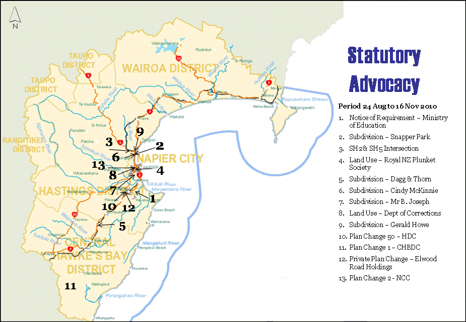
HAWKE’S BAY REGIONAL COUNCIL
Maori
Committee
Tuesday 23 November 2010
SUBJECT: General Business
INTRODUCTION:
This
document has been prepared to assist Councillors note the General Business to
be discussed as determined.
|
Item
|
Topic
|
Councillor
/ Staff
|
|
1.
|
|
|
|
2.
|
|
|
|
3.
|
|
|
|
4.
|
|
|
|
5.
|
|
|
|
6.
|
|
|
|
7.
|
|
|
|
8.
|
|
|
|
9.
|
|
|
|
10.
|
|
|
|
11.
|
|
|
|
12.
|
|
|
|
13.
|
|
|
|
14.
|
|
|
|
15.
|
|
|
|
16.
|
|
|